

Evaluating the Relation of Cave Passage Formation to Stress-Field: Spatio-Temporal Correlation of Speleogenesis with Active Tectonics in Asprorema Cave (Mt. Pinovo, Greece)

 ,
,  , ,
, ,  and
and 
Abstract
1. Introduction
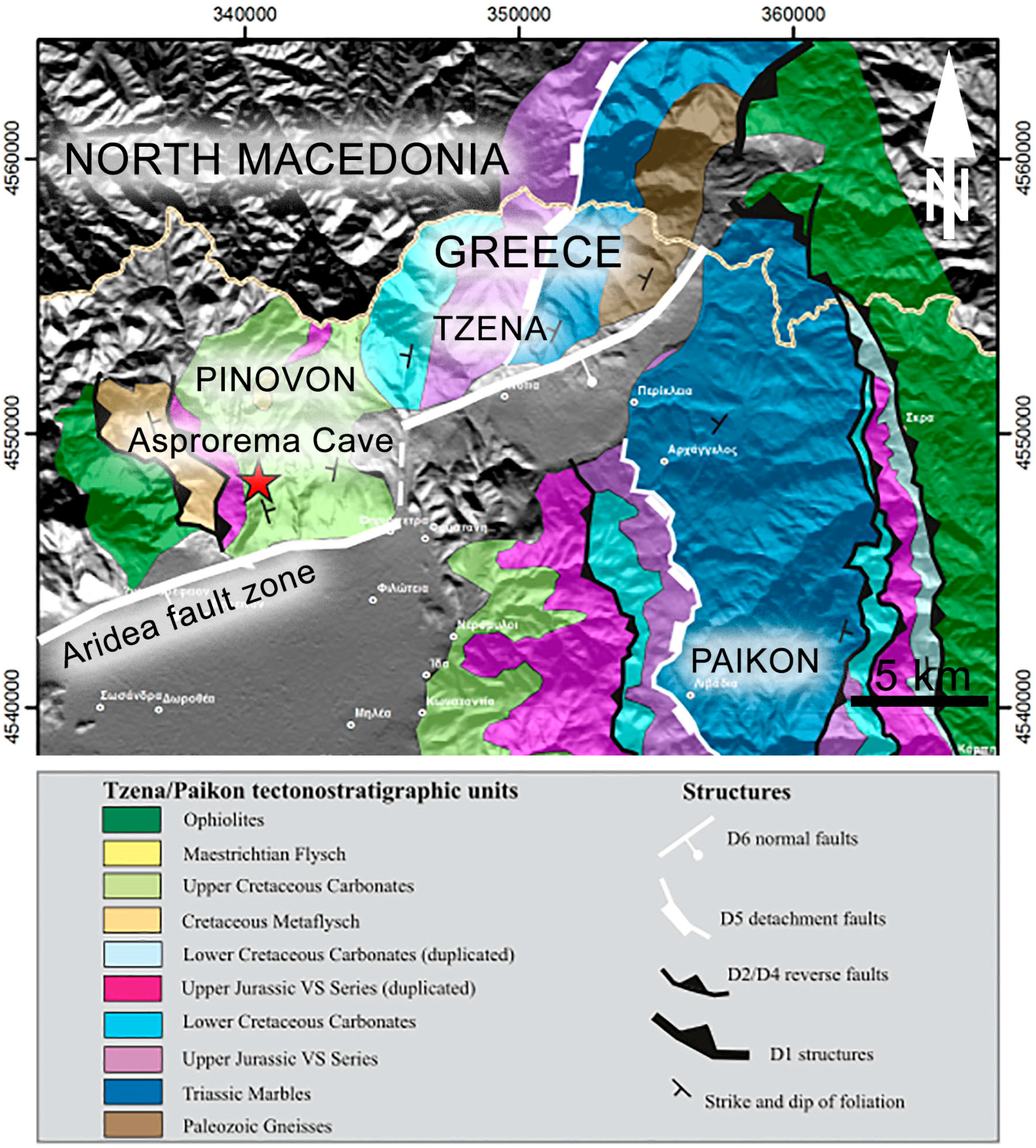
2. Geological Setting—Deformation History
3. Methods
4. Results
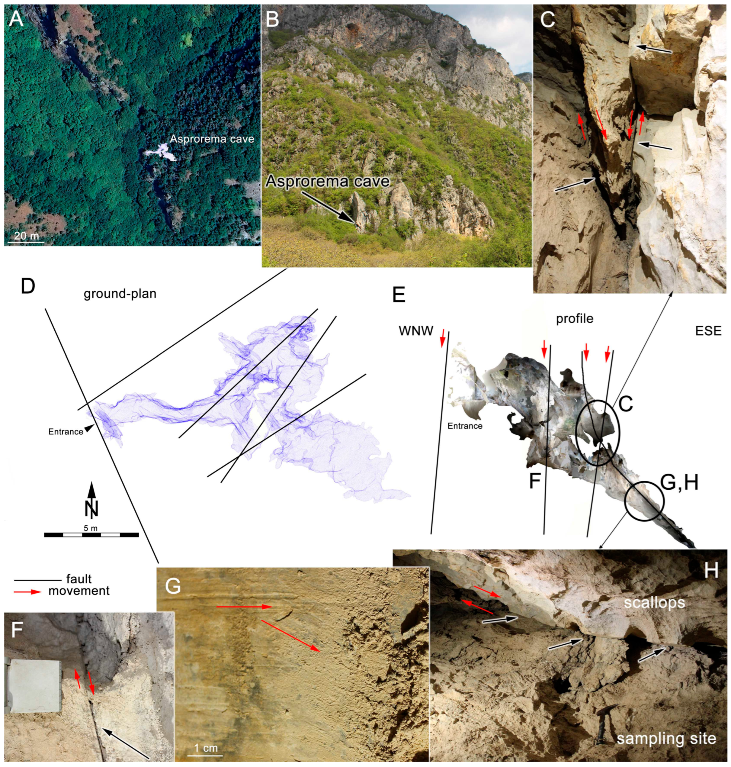
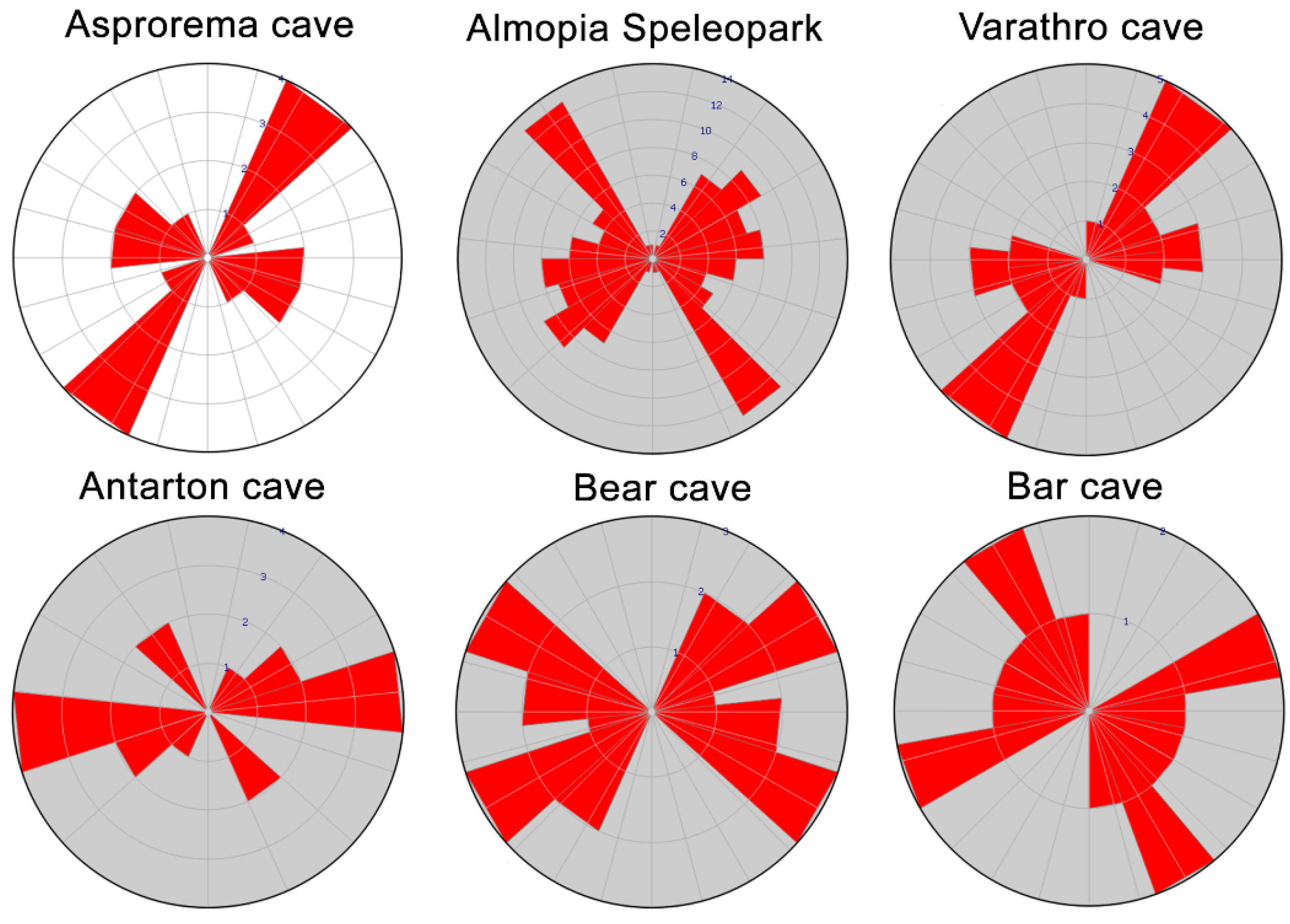
4.1. Cave Geomorphology
4.2. Mineralogy
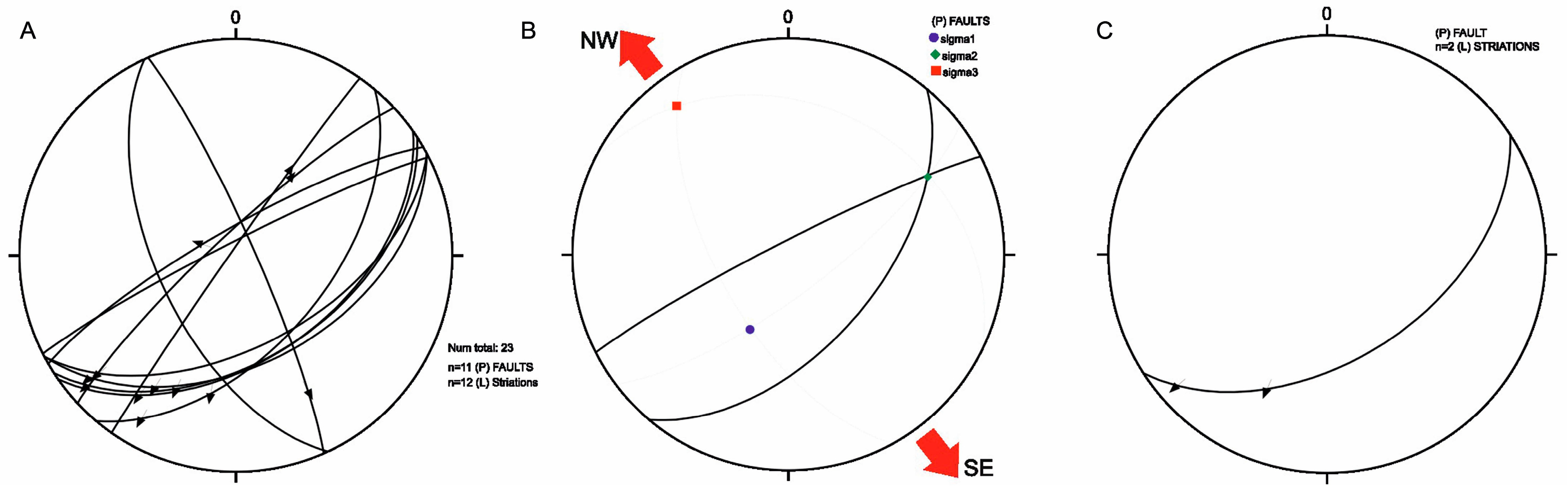
4.3. Cave Tectonics
5. Discussion
6. Conclusions
Author Contributions
Funding
Data Availability Statement
Acknowledgments
Conflicts of Interest
References
- White, W.B. Cave sediments and paleoclimate. J. Cave Karst Stud. 2007, 69, 76–93. [Google Scholar]
- Frumkin, A.; Fischhendler, I. Morphometry and distribution of isolated caves as a guide for phreatic and confined paleohydrological conditions. Geomorphology 2005, 67, 457–471. [Google Scholar] [CrossRef]
- Baroň, I.; Plan, L.; Sokol, L.; Grasemann, B.; Melichar, R.; Mitrovic, I.; Stemberk, J. Present-day kinematic behaviour of active faults in the Eastern Alps. Tectonophysics 2019, 752, 1–23. [Google Scholar] [CrossRef]
- Becker:, A.; Davenport, C.A.; Eichenberger, U.; Gilli, E.; Jeannin, P.Y.; Lacave, C. Speleoseismology: A critical perspective. J. Seismol. 2006, 10, 371–388. [Google Scholar] [CrossRef]
- Becker, A.; Häuselmann, P.; Eikenberg, J.; Gilli, E. Active tectonics and earthquake destructions in caves of northern and central Switzerland. Int. J. Speleol. 2012, 41, 5. [Google Scholar] [CrossRef]
- Briestenský, M.; Košťák, B.; Stemberk, J.; Petro, L.; Vozar, J.; Fojtikova, L. Active tectonic fault microdisplacement analyses: A comparison of results from surface and underground monitoring in western Slovakia. Acta Geodyn. Geomater. 2010, 7, 387–397. [Google Scholar]
- Briestenský, M.; Stemberk, J.; Michalik, J.; Bella, P.; Rowberry, M. The use of a karstic cave system in a study of active tectonics: Fault movements recorded at driny cave, male Karpaty mts (Slovakia). J. Cave Karst Stud. 2011, 73, 114–123. [Google Scholar] [CrossRef]
- Littva, J.; Hok, J.; Bella, P. Cavitonics: Using caves in active tectonic studies (Western Carpathians, case study). J. Struct. Geol. 2015, 80, 47–56. [Google Scholar] [CrossRef]
- Grasemann, B.; Plan, L.; Baroň, I.; Scholz, D. Co-seismic deformation of the 2017 Mw 6.6 Bodrum–Kos earthquake in speleothems of Korakia Cave (Pserimos, Dodecanese, Greece). Geomorphology 2022, 402, 108137. [Google Scholar] [CrossRef]
- Postpischl, D.; Agostini, S.; Forti, P.; Quinif, Y. Palaeoseismicity from karst sediments: The »Grotta del Cervo« cave case study (central Italy). In Investigation of Historical Earthquakes in Europe; Stucchi, M., Postpischl, D., Slejko, D., Eds.; Tectonophysics: Amsterdam, The Netherlands, 1991; Volume 193, pp. 33–44. [Google Scholar]
- Šebela, S. Broken speleothems as indicators of tectonic movements. Acta Carsologica 2008, 37, 51–62. [Google Scholar] [CrossRef]
- Szczygieł, J. Quaternary faulting in the Tatra Mountains, evidence from cave morphology and fault-slip analysis. Geol. Carpathica 2015, 66, 245–254. [Google Scholar] [CrossRef]
- Forti, P.; Postpischl, D. Seismotectonic and paleoseismic analyses using karst sediments. Mar. Geol. 1984, 55, 145–161. [Google Scholar] [CrossRef]
- Delaby, S. Palaeoseismic investigations in Belgian caves. Geol. En Mijnb. 2001, 80, 323–332. [Google Scholar] [CrossRef]
- Gilli, É. Review on the use of natural cave speleothems as palaeoseismic or neotectonics indicators. Comptes Rendus Geosci. 2005, 337, 1208–1215. [Google Scholar] [CrossRef]
- Kagan, E.J.; Agnon, A.; Bar-Matthews, M.; Ayalon, A. Dating large infrequent earthquakes by damaged cave deposits. Geology 2005, 33, 261–264. [Google Scholar] [CrossRef]
- Shanov, S.; Kostov, K. Dynamic Tectonics and Karst; Springer: Berlin/Heidelberg, Germany, 2014. [Google Scholar]
- Mavrides, A.; Matarangas, D.; Karfakis, J. Geological Map of Greece, 1:50000, Skra Sheet; Institute of Geology and Mineral Exploration: Athens, Greece, 1982. [Google Scholar]
- Galeos, A.; Karfakis, J.; Photiades, A. Geological Map of Greece, 1:50000, Promahi Sheet; Institute of Geology and Mineral Exploration: Athens, Greece, 2003. [Google Scholar]
- Katrivanos, E.; Kilias, A.; Mountrakis, D. Deformation history and correlation of Paikon and Tzena Terranes (Axios zone, Central Macedonia, Greece). Bull. Geol. Soc. Greece 2016, 50, 34–45. [Google Scholar] [CrossRef]
- Katrivanos, E. Structure, Kinematics and Tectonics of Paikon and Tzena Mountains (Central Macedonia, Greece). Ph.D. Thesis, Aristotle University, Department of Geology, Thessaloniki, Greece, 2017; p. 244. [Google Scholar]
- Mercier, J. Etude geologique des zones Internes des Hellenides en Macedoine centralle. Contribution a l’ etude du metamorphisme et de l’ evolution magmatique des zones internes des Hellenides. Ann. Geol. Pays Hell. 1968, 20, 1–739. [Google Scholar]
- Godfriaux, I.; Ricou, L.E. Le Paicon, une fenetre tectonique dans les Hellenides Internes (Macedoine, Grece). C. R. Acad. Sci. Paris 1991, 313, 1479–1484. [Google Scholar]
- Ricou, L.E.; Godfriaux, I. Une coupe a travers les ophiolites et gneiss allocthones entre le massif Pelagonien et la fenetre du Paikon (Grece du Nord). C. R. Acad. Sci. Paris 1991, 313, 1595–1601. [Google Scholar]
- Ricou, L.E.; Godfriaux, I. Mise au point sur la fenetre multiple du Paicon et la structure du Vardar en Grece. C. R. Acad. Sci. Paris 1995, 321, 601–608. [Google Scholar]
- Bonneau, M.; Godfriaux, I.; Moulas, Y.; Fourcade, E.; Masse, J. Stratigraphie et structure de la bordure orientale de la double fenetre du Paikon (Macedoine, Grece). Bull. Geol. Soc. Greece 1994, 30, 105–114. [Google Scholar]
- Brown, S.; Robertson, A. New structural evidence from the Mesozoic-early Tertiary Paicon unit, Northern Greece. Bull. Geol. Soc. Greece 1994, 30, 159–170. [Google Scholar]
- Brown, S.; Robertson, A. Sedimentary geology as a key to understanding the tectonic evolution of the Mesozoic—Early Tertiary Paikon Massif, Vardar suture zone, N. Greece. Sediment. Geol. 2003, 160, 179–212. [Google Scholar] [CrossRef]
- Ferriere, J.; Bonneau, M.; Caridroit, M.; Bellier, J.P.; Gorican, S.; Kollmann, H. Les nappes tertiaires du Paikon (zone de Vardar, Macédoine, Grèce): Arguments stratigraphique pour une nouvelle interprétation structurale. Comptes Rendus L’académie Sci.-Ser. IIA-Earth Planet. Sci. 2001, 332, 695–702. [Google Scholar]
- Mercier, J.; Vergely, P. The Paikon Massif revisited comments on the Late Cretaceous—Paleogene geodynamics of the Axios-Vardar zone. How many Jurassic ophiolitic basins? (Hellenides, Macedonia, Greece). Bull. Geol. Soc. Greece 2001, 34, 2099–2112. [Google Scholar] [CrossRef]
- Papanikolaou, D. Tectonostratigraphic models of the Alpine terranes and subduction history of the Hellenides. Tectonophysics 2013, 595–596, 1–24. [Google Scholar] [CrossRef]
- Katrivanos, E.; Kilias, A. and Mountrakis, D. Kinematics of deformation and structural evolution of the Paikon Massif (Central Macedonia, Greece): A Pelagonian tectonic window? N. Jb. Geol. Palaeont. Abh. 2013, 269, 149–171. [Google Scholar] [CrossRef]
- Pavlides, S.; Mountrakis, D.; Kilias, A.; Tranos, M. The role of strikeslip movements in the extensional area of the northern Aegean (Greece). Ann. Tecton. 1990, 4, 196–211. [Google Scholar]
- Katrivanos, E.; Mountrakis, D.; Kilias, A.; Pavlides, S. Preliminary results of the geological structure and kinematics of deformation in Tzena Mt. (Paikon Subzone, Central Macedonia, Greece). Bull. Geol. Soc. Greece 2001, 34, 137–147. (In Greek) [Google Scholar] [CrossRef]
- Häuselmann, P. UIS mapping grades. Int. J. Speleol. 2011, 40, 15. [Google Scholar]
- Dasher, G.R. On Station: A Complete Handbook for Surveying and Mapping Caves; National Speleological Society: Huntsville, AL, USA, 1994. [Google Scholar]
- Trimmis, K.P. Paperless mapping and cave archaeology: A review on the application of DistoX survey method in archaeological cave sites. J. Archaeol. Sci. Rep. 2018, 18, 399–407. [Google Scholar] [CrossRef]
- Lauritzen, S.-E.; Lundberg, J. Solutional and erosional morphology of caves. In Speleogenesis. Evolution of Karst Aquifers; Klimchouk, A., Ford, D.C., Palmer, A.N., Dreybrodt, W., Eds.; National Speleological Society: Huntsville, AL, USA, 2000; pp. 408–426. [Google Scholar]
- Gunn, J. Encyclopedia of Caves and Karst Science; Routledge: London, UK, 2004. [Google Scholar]
- White, W.B.; Culver, D.C. Encyclopedia of Caves; Elsevier: Amsterdam, The Netherlands, 2005. [Google Scholar]
- Ford, D.; Williams, P.D. Karst Hydrogeology and Geomorphology; John Wiley and Sons Inc.: New York, NY, USA, 2007. [Google Scholar]
- Curl, R. Scallops and Flutes. Trans. Cave Res. Group Great Br. 1966, 7, 121–160. [Google Scholar]
- Curl, R.L. Deducing Flow Velocity in Cave Conduits from Scallops. Natl. Speleol. Soc. Bull. 1974, 36, 22. [Google Scholar]
- Lauritzen, S.E. Scallop Dominant Discharge. In Proceedings of the 10th International Congress of Speleology, Budapest, Hungary, 13–20 August 1989; pp. 123–124. [Google Scholar]
- Murphy, P.J. Scallops. In Encyclopedia of Caves; White, W.B., Culver, D.C., Eds.; Elsevier: Amsterdam, The Netherlands, 2012; pp. 679–983. [Google Scholar]
- Hammer, Ř.; Harper, D.A.T.; Ryan, P.D. PAST: Paleontological Statistics Software Package for Education and Data Analysis. Palaeontoogia 2001, 4, 9. [Google Scholar]
- Woodward, E.; Sasowsky, I.D. A spreadsheet program (ScallopEx) to calculate paleovelocities from cave wall scallops. Acta Carsologica 2009, 38, 303–305. [Google Scholar] [CrossRef]
- Palmer, A. Hydrogeologic control of cave patterns. In Speleogenesis. Evolution of Karst Aquifers; Klimchouk, A., Ford, D.C., Palmer, A.N., Dreybrodt, W., Eds.; National Speleological Society: Huntsville, AL, USA, 2000; pp. 77–90. [Google Scholar]
- Lazaridis, G. Speleological research in the Loutra Arideas area (Macedonia, Greece). Neue Forschun-Gen Zum Höhlenbären Eur. 2005, 45, 57–64. [Google Scholar]
- Lazaridis, G. Almopia Speleopark (Pella, Mac-edonia, Greece): Morphology-Speleogenesis of the caves. Sci. Ann. Sch. Geol. Aristotle Univ. Thessalon. 2006, 98, 33–40. [Google Scholar]
- Lazaridis, G.; Melfos, V. Morphological features and formation conditions of The Almopia Speleopark caves (Loutra Almopias, N. Greece). Acta Carsologica 2021, 50, 37–48. [Google Scholar] [CrossRef]

Disclaimer/Publisher’s Note: The statements, opinions and data contained in all publications are solely those of the individual author(s) and contributor(s) and not of MDPI and/or the editor(s). MDPI and/or the editor(s) disclaim responsibility for any injury to people or property resulting from any ideas, methods, instructions or products referred to in the content. |
© 2024 by the authors. Licensee MDPI, Basel, Switzerland. This article is an open access article distributed under the terms and conditions of the Creative Commons Attribution (CC BY) license (https://creativecommons.org/licenses/by/4.0/).
Share and Cite
Lazaridis, G.; Katrivanos, E.; Dora, D.; Papadopoulou, L.; Lazos, I.; Chatzipetros, A. Evaluating the Relation of Cave Passage Formation to Stress-Field: Spatio-Temporal Correlation of Speleogenesis with Active Tectonics in Asprorema Cave (Mt. Pinovo, Greece). Geosciences 2024, 14, 126. https://doi.org/10.3390/geosciences14050126
Lazaridis G, Katrivanos E, Dora D, Papadopoulou L, Lazos I, Chatzipetros A. Evaluating the Relation of Cave Passage Formation to Stress-Field: Spatio-Temporal Correlation of Speleogenesis with Active Tectonics in Asprorema Cave (Mt. Pinovo, Greece). Geosciences. 2024; 14(5):126. https://doi.org/10.3390/geosciences14050126
Chicago/Turabian StyleLazaridis, Georgios, Emmanouil Katrivanos, Despoina Dora, Lambrini Papadopoulou, Ilias Lazos, and Alexandros Chatzipetros. 2024. "Evaluating the Relation of Cave Passage Formation to Stress-Field: Spatio-Temporal Correlation of Speleogenesis with Active Tectonics in Asprorema Cave (Mt. Pinovo, Greece)" Geosciences 14, no. 5: 126. https://doi.org/10.3390/geosciences14050126
APA StyleLazaridis, G., Katrivanos, E., Dora, D., Papadopoulou, L., Lazos, I., & Chatzipetros, A. (2024). Evaluating the Relation of Cave Passage Formation to Stress-Field: Spatio-Temporal Correlation of Speleogenesis with Active Tectonics in Asprorema Cave (Mt. Pinovo, Greece). Geosciences, 14(5), 126. https://doi.org/10.3390/geosciences14050126