

Spatial and Temporal Patterns of Land Subsidence and Sinkhole Occurrence in the Konya Endorheic Basin, Turkey

 ,
,  ,
,  , , and
Abstract
:1. Introduction
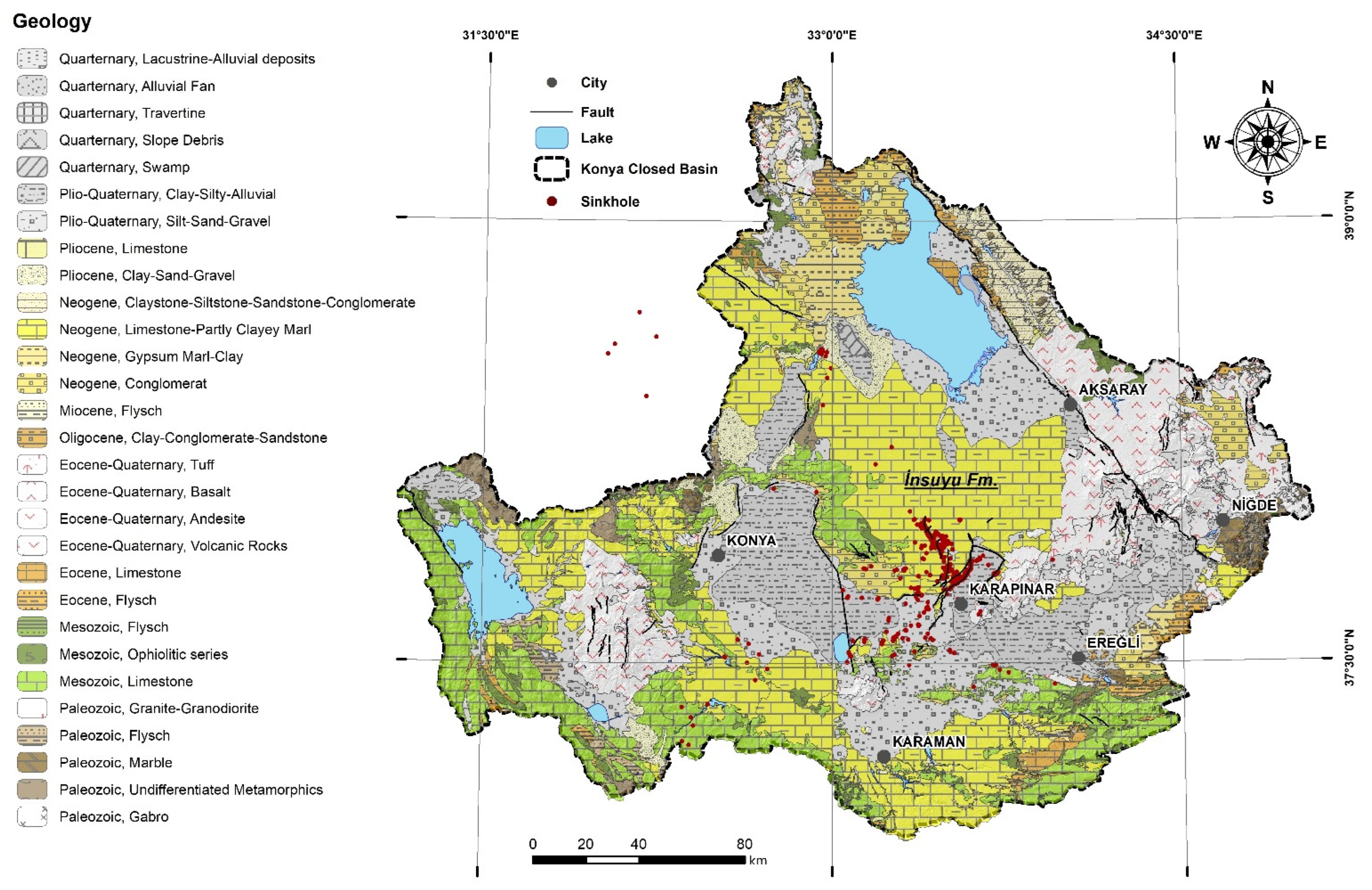
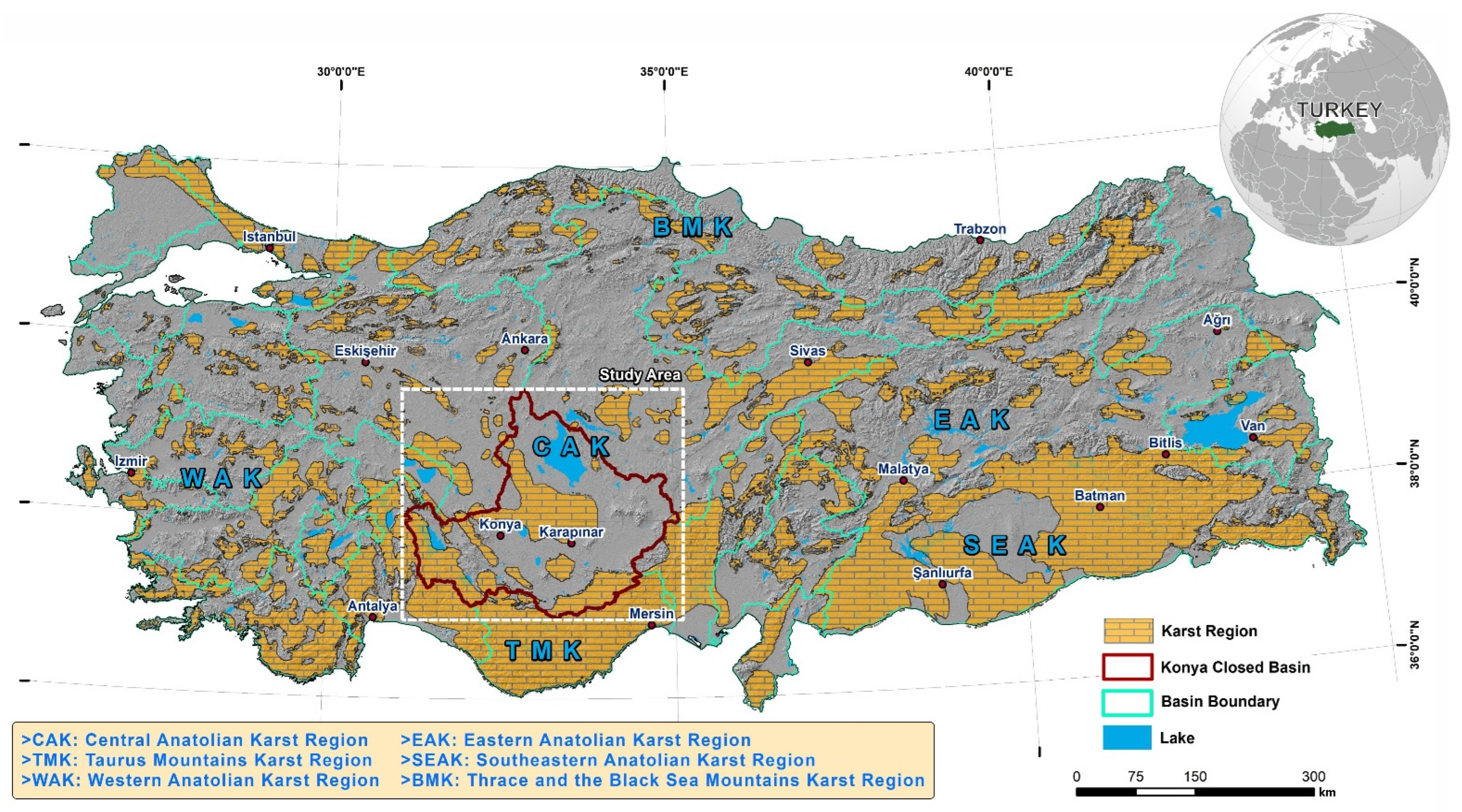
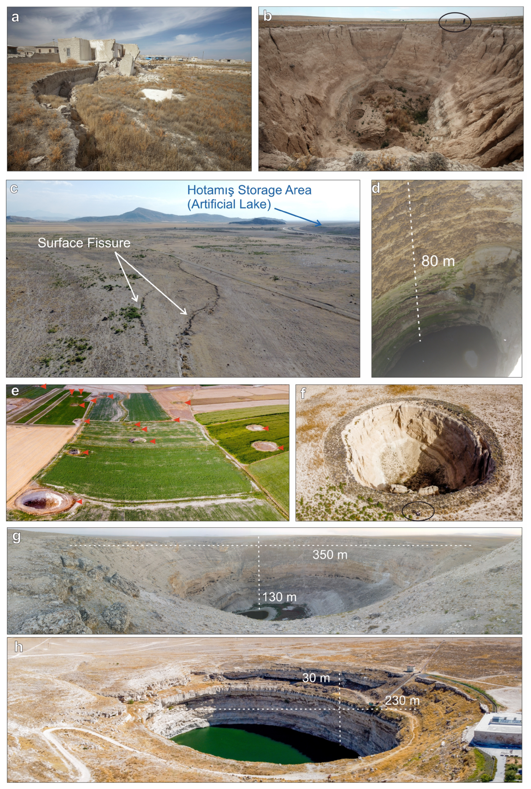
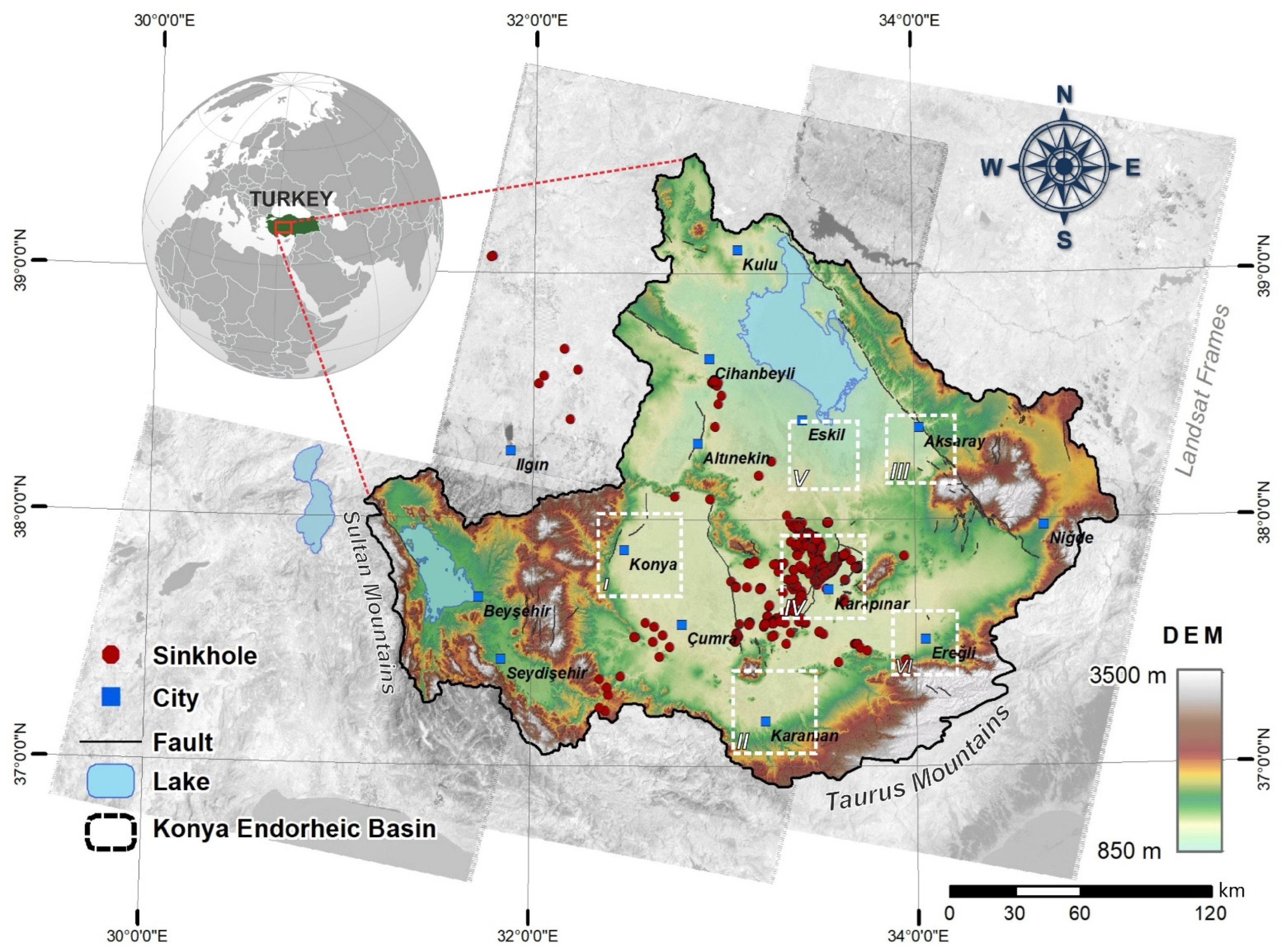
2. Study Area and Hydrogeology
3. Data and Methodology
InSAR Processing
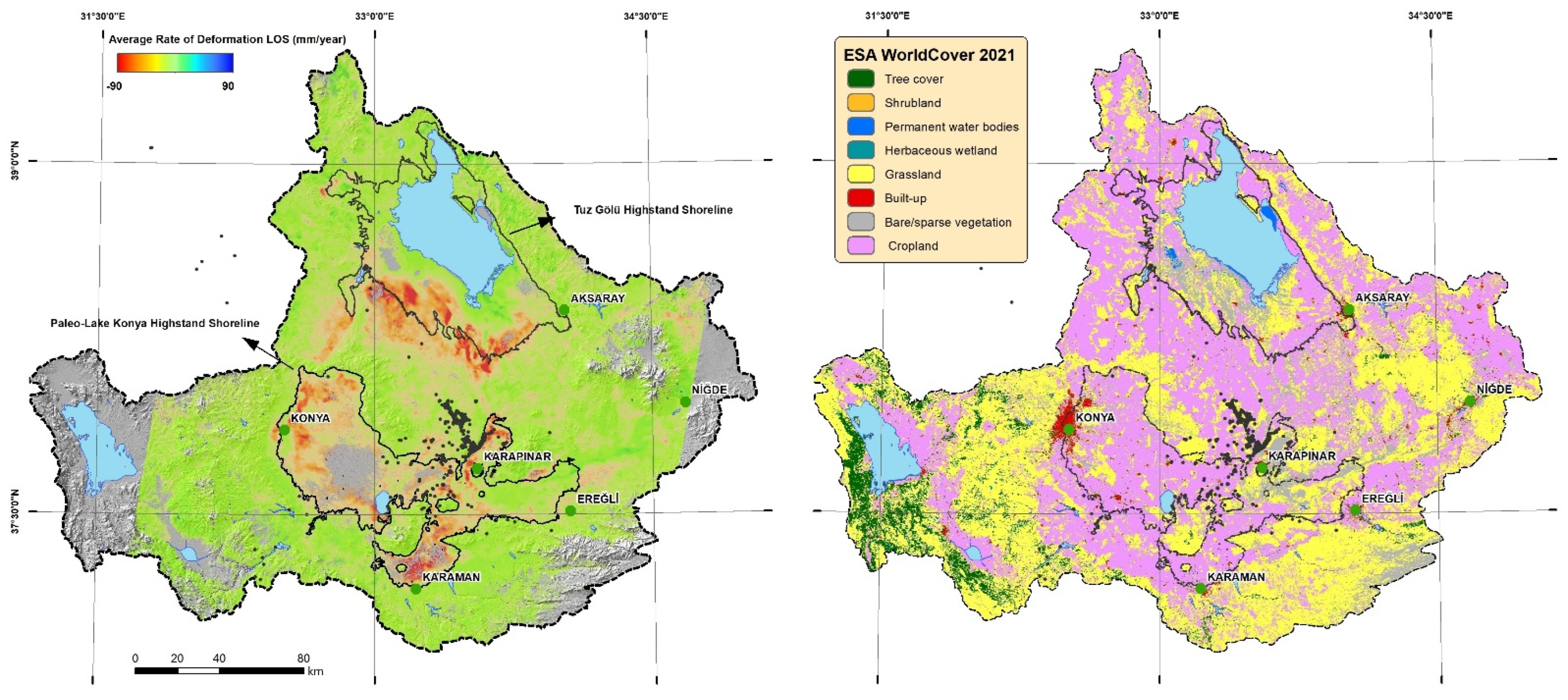
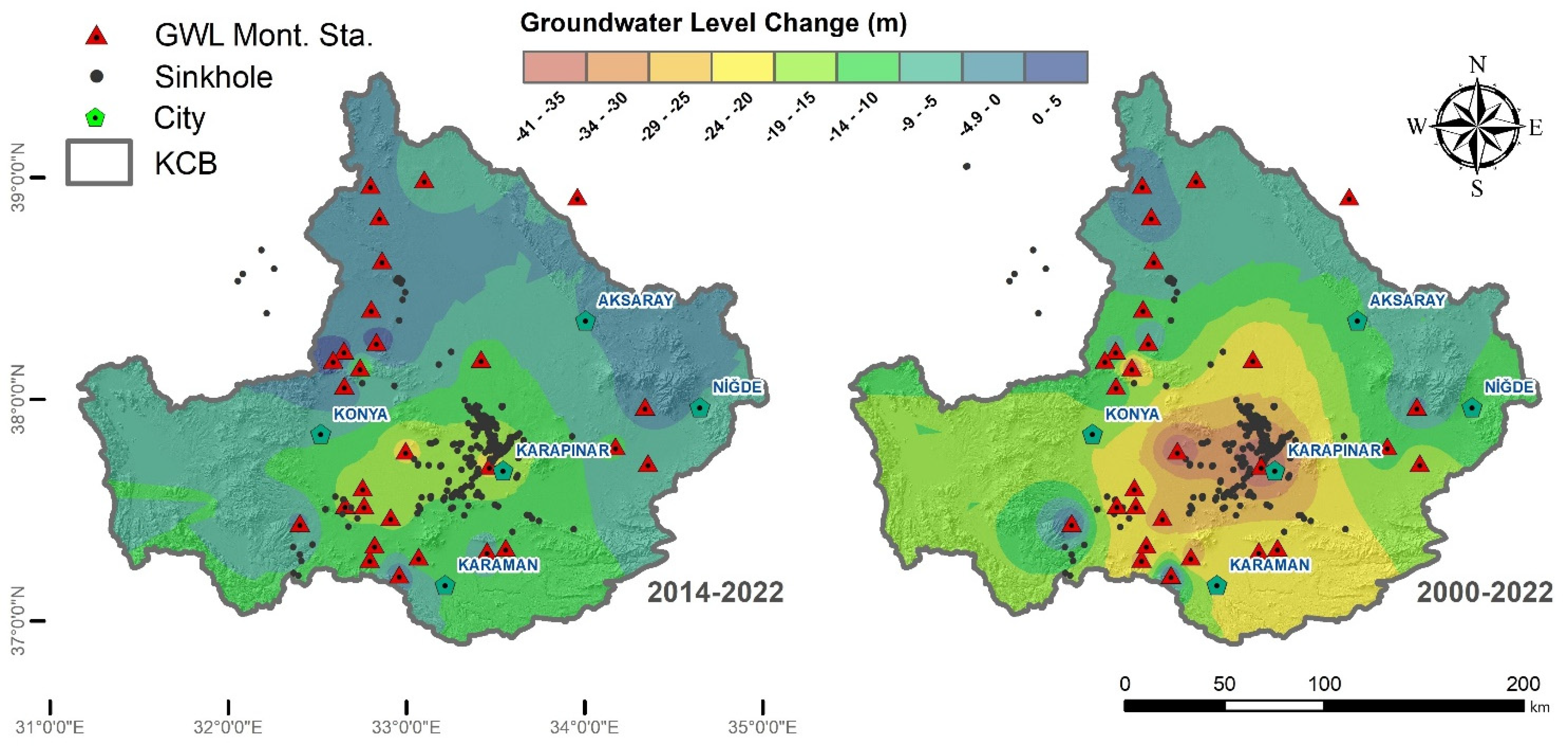
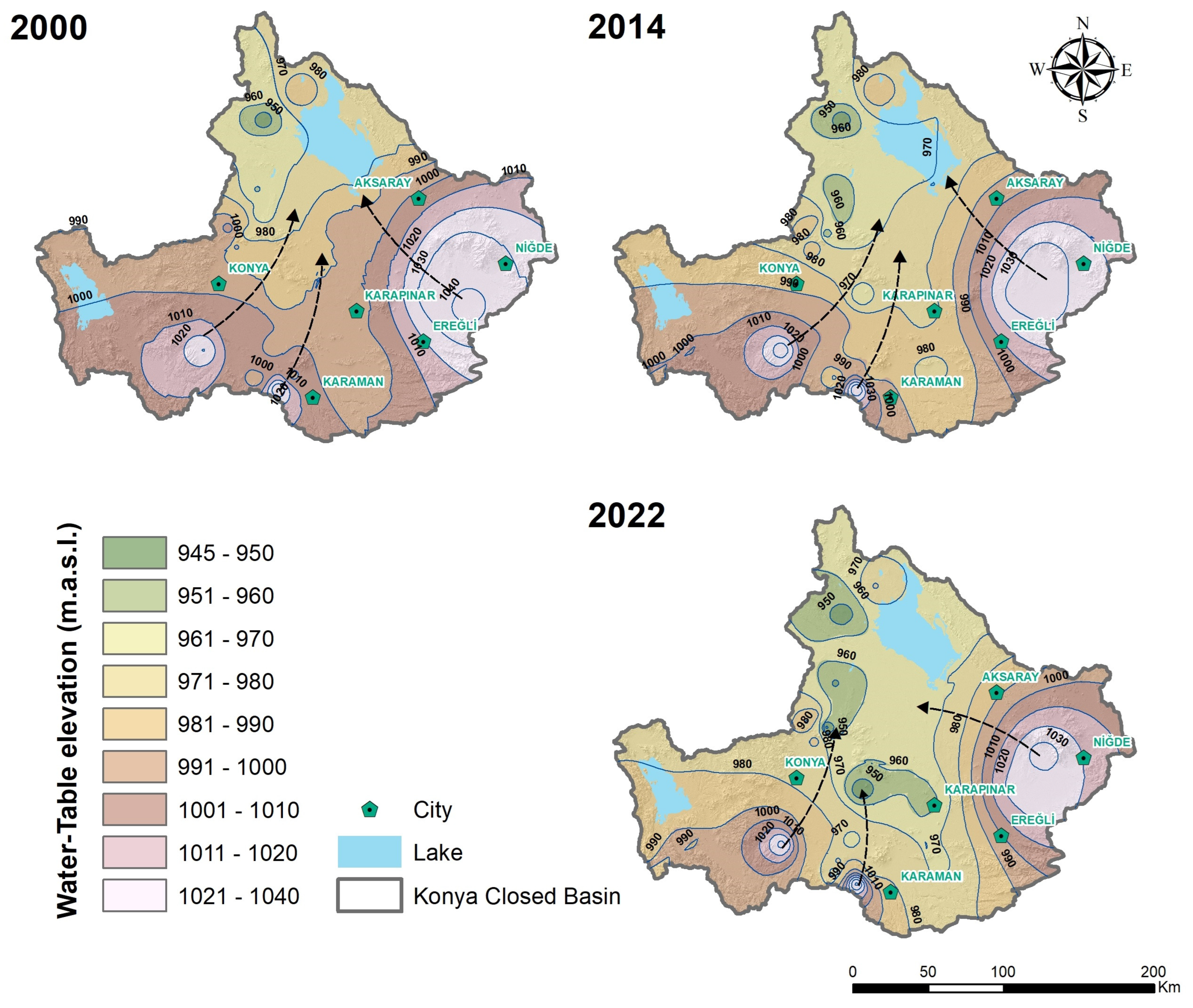
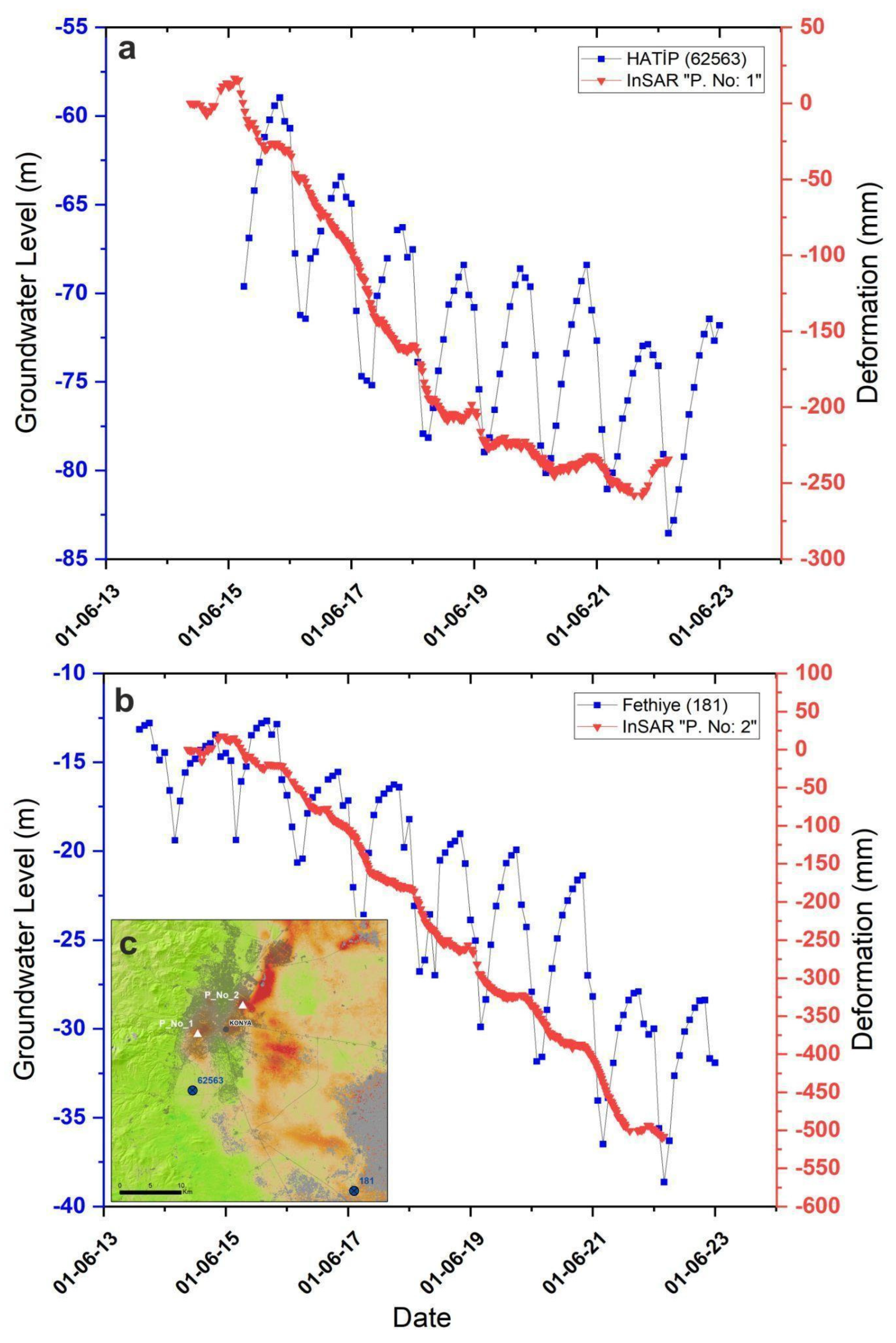
4. Results
5. Discussion
6. Conclusions
Author Contributions
Funding
Data Availability Statement
Acknowledgments
Conflicts of Interest
References
- Ford, D.; Williams, P. Karst Hydrogeology and Geomorphology; Wiley: Chichester, UK, 2007; ISBN 9780470849965. [Google Scholar]
- De Waele, J.; Gutiérrez, F. Karst Hydrogeology, Geomorphology and Caves; Wiley: Hoboken, NJ, USA, 2022; ISBN 9781119605348. [Google Scholar]
- Nazik, L.; Poyraz, M.; Karabıyıkoğlu, M. Landscapes and Landforms of Turkey. In World Geomorphological Landscapes—Karst Landscapes and Landforms in Turkey; Kuzucuoğlu, C., Çiner, A., Kazancı, N., Eds.; World Geomorphological Landscapes; Springer Nature: Cham, Switzerland, 2019; ISBN 978-3-030-03513-6. [Google Scholar]
- Şengör, A.M.C.; Görür, N.; Şaroğlu, F. Strike-Slip Faulting and Related Basin Formation in Zones of Tectonic Escape: Turkey as a Case Study; SEPM Society for Sedimentary Geology: Claremore, OK, USA, 1985. [Google Scholar]
- Gürbüz, A.; Kazancí, N. Genetic Framework of Neogene-Quaternary Basin Closure Process in Central Turkey. Lithosphere 2015, 7, 421–426. [Google Scholar] [CrossRef]
- Melnick, D.; Yıldırım, C.; Hillemann, C.; Garcin, Y.; Çiner, A.; Pérez-Gussinyé, M.; Strecker, M.R. Slip along the Sultanhanı Fault in Central Anatolia from Deformed Pleistocene Shorelines of Palaeo-Lake Konya and Implications for Seismic Hazards in Low-Strain Regions. Geophys. J. Int. 2017, 209, 1431–1454. [Google Scholar] [CrossRef]
- Nagehan Ucan, H.; Dursun, S. Environmental Problems of Tuz Lake (Konya-Turkey). J. Int. Environ. Appl. Sci. 2009, 4, 231–233. [Google Scholar]
- Aydin, F.; Erlat, E.; Türkeş, M. Impact of Climate Variability on the Surface of Lake Tuz (Turkey), 1985–2016. Reg. Environ. Chang. 2020, 20, 68. [Google Scholar] [CrossRef]
- Nazik, L.; Tuncer, K. Regional Features of Turkish Karst Morphology. Turk. J. Speleol. Karst Cave Res. 2010, 1, 7–19. [Google Scholar]
- Tudryn, A.; Motavalli-Anbaran, S.H.; Tucholka, P.; Gibert-Brunet, E.; Lankarani, M.; Ahmady-Birgani, H.; Kong, T.; Noret, A.; Miska, S.; Massault, M.; et al. Late Quaternary Environmental Changes of Lake Urmia Basin (NW Iran) Inferred from Sedimentological and Magnetic Records. Quat. Int. 2021, 589, 83–94. [Google Scholar] [CrossRef]
- Vey, S.; Al-Halbouni, D.; Haghshenas, M.; Alshawaf, F.; Vüllers, J.; Güntner, A.; Dick, G.; Ramatschi, M.; Teatini, P.; Wickert, J.; et al. Delayed Subsidence of the Dead Sea Shore Due to Hydro-Meteorological Changes. Sci. Rep. 2021, 11, 13518. [Google Scholar] [CrossRef] [PubMed]
- Hansen, K. NASA Disappearing Lake Tuz. Available online: https://earthobservatory.nasa.gov/images/149211/disappearing-lake-tuz (accessed on 1 December 2023).
- Kilic, O.; Kilic, A.M. Salt Crust Mineralogy and Geochemical Evolution of the Salt Lake (Tuz Gölü), Turkey. Sci. Res. Essays 2010, 5, 1317–1324. [Google Scholar]
- Demir, V. Trend Analysis of Lakes and Sinkholes in the Konya Closed Basin, in Turkey. Nat. Hazards 2022, 112, 2873–2912. [Google Scholar] [CrossRef]
- Orhan, O.; Yakar, M.; Ekercin, S. An Application on Sinkhole Susceptibility Mapping by Integrating Remote Sensing and Geographic Information Systems. Arab. J. Geosci. 2020, 13, 886. [Google Scholar] [CrossRef]
- Al-Halbouni, D.; Holohan, E.P.; Saberi, L.; Alrshdan, H.; Sawarieh, A.; Closson, D.; Walter, T.R.; Dahm, T. Sinkholes, Subsidence and Subrosion on the Eastern Shore of the Dead Sea as Revealed by a Close-Range Photogrammetric Survey. Geomorphology 2017, 285, 305–324. [Google Scholar] [CrossRef]
- Nikraftar, Z.; Parizi, E.; Hosseini, S.M.; Ataie-Ashtiani, B. Lake Urmia Restoration Success Story: A Natural Trend or a Planned Remedy? J. Great Lakes Res. 2021, 47, 955–969. [Google Scholar] [CrossRef]
- Scheidt, J.; Lerche, I.; Paleologos, E.K. Environmental and Economic Risks from Sinkholes in West-Central Florida. Environ. Geosci. 2005, 12, 207–217. [Google Scholar] [CrossRef]
- Festa, V.; Fiore, A.; Parise, M.; Siniscalchi, A. Sinkhole Evolution in the Apulian Karst of Southern Italy: A Case Study, with Some Considerations on Sinkhole Hazards. J. Cave Karst Stud. 2012, 74, 137–147. [Google Scholar] [CrossRef]
- Jiang, H.; Balz, T.; Li, J.; Mishra, V. Preliminary Investigation of Sudden Ground Subsidence and Building Tilt in Balitai Town, Tianjin City, on 31 May 2023. Remote Sens. 2023, 15, 4891. [Google Scholar] [CrossRef]
- Kim, J.-W.; Lu, Z.; Degrandpre, K. Ongoing Deformation of Sinkholes in Wink, Texas, Observed by Time-Series Sentinel-1A SAR Interferometry (Preliminary Results). Remote Sens. 2016, 8, 313. [Google Scholar] [CrossRef]
- Gao, Y.; Alexander, E.C. Sinkhole Hazard Assessment in Minnesota Using a Decision Tree Model. Environ. Geol. 2008, 54, 945–956. [Google Scholar] [CrossRef]
- Goodbar, A.; Powers, D.; Goodbar, J.; Holt, R. Karst and Sinkholes at Nash Draw, Southeastern New Mexico (USA). In Proceedings of the 16th Multidisciplinary Conference on Sinkholes and the Engineering and Environmental Impacts of Karst, San Juan, Puerto Rico, 20–24 April 2020; National Cave and Karst Research Institute: Carlsbad, NM, USA, 2020. [Google Scholar]
- Kaufmann, O.; Quinif, Y. Geohazard Map of Cover-Collapse Sinkholes in the “Tournaisis” Area, Southern Belgium. Eng. Geol. 2002, 65, 117–124. [Google Scholar] [CrossRef]
- Margiotta, S.; Marini, G.; Fay, S.; D’Onghia, F.M.; Liso, I.S.; Parise, M.; Pinna, M. Hydro-Stratigraphic Conditions and Human Activity Leading to Development of a Sinkhole Cluster in a Mediterranean Water Ecosystem. Hydrology 2021, 8, 111. [Google Scholar] [CrossRef]
- Guarino, P.M.; Nisio, S. Anthropogenic Sinkholes in the Territory of the City of Naples (Southern Italy). Phys. Chem. Earth 2012, 49, 92–102. [Google Scholar] [CrossRef]
- Galve, J.P.; Gutiérrez, F.; Lucha, P.; Bonachea, J.; Remondo, J.; Cendrero, A.; Gutiérrez, M.; Gimeno, M.J.; Pardo, G.; Sánchez, J.A. Sinkholes in the Salt-Bearing Evaporite Karst of the Ebro River Valley Upstream of Zaragoza City (NE Spain). Geomorphological Mapping and Analysis as a Basis for Risk Management. Geomorphology 2009, 108, 145–158. [Google Scholar] [CrossRef]
- Nof, R.N.; Abelson, M.; Raz, E.; Magen, Y.; Atzori, S.; Salvi, S.; Baer, G. SAR Interferometry for Sinkhole Early Warning and Susceptibility Assessment along the Dead Sea, Israel. Remote Sens. 2019, 11, 89. [Google Scholar] [CrossRef]
- Al-Halbouni, D.; AlRabayah, O.; Nakath, D.; Rüpke, L. A Vision on a UNESCO Global Geopark at the Southeastern Dead Sea in Jordan—How Natural Hazards May Offer Geotourism Opportunities. Land 2022, 11, 553. [Google Scholar] [CrossRef]
- Taheri, K.; Gutiérrez, F.; Mohseni, H.; Raeisi, E.; Taheri, M. Sinkhole Susceptibility Mapping Using the Analytical Hierarchy Process (AHP) and Magnitude–Frequency Relationships: A Case Study in Hamadan Province, Iran. Geomorphology 2015, 234, 64–79. [Google Scholar] [CrossRef]
- Gökkaya, E.; Gutiérrez, F. Poljes in the Sivas Gypsum Karst, Turkey. Geomorphology 2022, 417, 108451. [Google Scholar] [CrossRef]
- Ozdemir, A. Sinkhole Susceptibility Mapping Using Logistic Regression in Karapınar (Konya, Turkey). Bull. Eng. Geol. Environ. 2016, 75, 681–707. [Google Scholar] [CrossRef]
- Orhan, O.; Oliver-Cabrera, T.; Wdowinski, S.; Yalvac, S.; Yakar, M. Land Subsidence and Its Relations with Sinkhole Activity in Karapınar Region, Turkey: A Multi-Sensor InSAR Time Series Study. Sensors 2021, 21, 774. [Google Scholar] [CrossRef]
- Gutiérrez, F. Sinkhole Hazards. In Oxford Research Encyclopedia of Natural Hazard Science; Oxford University Press: Oxford, UK, 2016. [Google Scholar]
- Kashima, K. Environmental and Climatic Changes during the Last 20,000 Years at Lake Tuz, Central Turkey. CATENA 2002, 48, 3–20. [Google Scholar] [CrossRef]
- Roberts, N. Age, Palaeoenvironments, and Climatic Significance of Late Pleistocene Konya Lake, Turkey. Quat. Res. 1983, 19, 154–171. [Google Scholar] [CrossRef]
- Kuzucuoglu, C.; Parish, R.; Karabiyikoglu, M. The Dune Systems of the Konya Plain (Turkey): Their Relation to Environmental Changes in Central Anatolia during the Late Pleistocene and Holocene. Geomorphology 1998, 23, 257–271. [Google Scholar] [CrossRef]
- Dursun, A.E. Risk Analysis of Natural Sinkholes Hazards in Karapınar Basin (Konya, Turkey). Arab. J. Geosci. 2022, 15, 279. [Google Scholar] [CrossRef]
- Ozdemir, A. Investigation of Sinkholes Spatial Distribution Using the Weights of Evidence Method and GIS in the Vicinity of Karapinar (Konya, Turkey). Geomorphology 2015, 245, 40–50. [Google Scholar] [CrossRef]
- Günay, G.; Çörekçioǧlu, I.; Övül, G. Geologic and Hydrogeologic Factors Affecting Sinkhole (Obruk) Development in Central Turkey. Carbonates Evaporites 2011, 26, 3–9. [Google Scholar] [CrossRef]
- Doǧan, U.; Yilmaz, M. Natural and Induced Sinkholes of the Obruk Plateau and Karapidotlessnar-Hotamiş Plain, Turkey. J. Asian Earth Sci. 2011, 40, 496–508. [Google Scholar] [CrossRef]
- Waltham, T. Large Collapse Sinkholes, Old and New, in the Obruk Plateau, Turkey. Cave Karst Sci. 2015, 42, 125–130. [Google Scholar]
- Watson, R.A.; Holohan, E.P.; Al-Halbouni, D.; Saberi, L.; Sawarieh, A.; Closson, D.; Alrshdan, H.; Abou Karaki, N.; Siebert, C.; Walter, T.R.; et al. Sinkholes and Uvalas in Evaporite Karst: Spatio-Temporal Development with Links to Base-Level Fall on the Eastern Shore of the Dead Sea. Solid Earth 2019, 10, 1451–1468. [Google Scholar] [CrossRef]
- Sevil, J.; Gutiérrez, F. Morphometry and Evolution of Sinkholes on the Western Shore of the Dead Sea. Implications for Susceptibility Assessment. Geomorphology 2023, 434, 108732. [Google Scholar] [CrossRef]
- Wadas, S.H.; Buness, H.; Rochlitz, R.; Skiba, P.; Günther, T.; Grinat, M.; Tanner, D.C.; Polom, U.; Gabriel, G.; Krawczyk, C.M. Geophysical Analysis of an Area Affected by Subsurface Dissolution—Case Study of an Inland Salt Marsh in Northern Thuringia, Germany. Solid Earth 2022, 13, 1673–1696. [Google Scholar] [CrossRef]
- Pasvanoǧlu, S.; Güner, A.; Gültekin, F. Environmental Problems at the Nevşehir (Kozakli) Geothermal Field, Central Turkey. Environ. Earth Sci. 2012, 66, 549–560. [Google Scholar] [CrossRef]
- Hermosilla, R.G. The Guatemala City Sinkhole Collapses. Carbonates Evaporites 2012, 27, 103–107. [Google Scholar] [CrossRef]
- Sandhu, D.; Singh, A.; Duranceau, S.J.; Nam, B.H.; Mayo, T.; Wang, D. Fate and Transport of Radioactive Gypsum Stack Water Entering the Floridan Aquifer Due to a Sinkhole Collapse. Sci. Rep. 2018, 8, 11439. [Google Scholar] [CrossRef] [PubMed]
- Günay, G.; Çörekçioğlu, I. Konya-Karapinar Sinkholes (Obruks) of Turkey. In Caves and Karst of Turkey—Volume 2: Geology, Hydrogeology and Karst; Günay, G., Törk, K., Güner, İ.N., Gilli, E., Eds.; Springer International Publishing: Cham, Switzerland, 2022; pp. 27–39. ISBN 978-3-030-95361-4. [Google Scholar]
- Bayari, C.S.; Pekkan, E.; Ozyurt, N.N. Obruks, as Giant Collapse Dolines Caused by Hypogenic Karstification in Central Anatolia, Turkey: Analysis of Likely Formation Processes. Hydrogeol. J. 2009, 17, 327–345. [Google Scholar] [CrossRef]
- Orhan, O. Monitoring of Land Subsidence Due to Excessive Groundwater Extraction Using Small Baseline Subset Technique in Konya, Turkey. Environ. Monit. Assess. 2021, 193, 174. [Google Scholar] [CrossRef] [PubMed]
- Kaya, B.; Aladağ, C. Precipitation, Temperature and Vegetation Relations in the Conditions of Konya. J. Selçuk Univ. Soc. Sci. Inst. 2009, 22, 265–278. [Google Scholar]
- Sarış, F.; Gedik, F. Meteorological Drought Analysis in Konya Closed Basin. J. Geogr. 2021, 42, 295–308. [Google Scholar] [CrossRef]
- Demir, V.; Keskin, A.Ü. Height Modeling with Artificial Neural Networks (Samsun-Mert River Basin). Gazi J. Eng. Sci. 2020, 6, 54–61. [Google Scholar] [CrossRef]
- Demir, V.; Keskin, A.Ü. Water Level Change of Lakes and Sinkholes in Central Turkey under Anthropogenic Effects. Theor. Appl. Climatol. 2020, 142, 929–943. [Google Scholar] [CrossRef]
- Okay, A.I.; Tüysüz, O. Tethyan Sutures of Northern Turkey. Geol. Soc. Lond. Spec. Publ. 1999, 156, 475–515. [Google Scholar] [CrossRef]
- Ulu, Ü. Geological Maps of Turkey Karaman-M30 Sheet. In General Directorate of Mineral Research and Exploration; General Directorate of Mineral Research and Exploration: Ankara, Turkey, 2009. (In Turkish) [Google Scholar]
- Ulu, Ü. Geological Maps of Turkey Karaman-M31 Sheet. In General Directorate of Mineral Research and Exploration; General Directorate of Mineral Research and Exploration: Ankara, Turkey, 2009. (In Turkish) [Google Scholar]
- Törk, K.; Erduran, B.; Yılmaz, N.P.; Sülükçü, S.; Güner, İ.N.; Ateş, Ş.; Mutlu, G.; Keleş, S.; Çınar, A.; Demirbaş, Ş.; et al. Identification and Hazard Assessment of Karst Depression Areas in the Konya Basin; Report No. 11250; MTA General Directorate, Geological Surveys Department: Ankara, Turkey, 2013.
- Canik, B.; Arıgün, Z. Formation of Sinkholes around Karapınar-Kızören (Konya) and the Effect of Karapınar Volcanism on This Event. In Proceedings of the Karapınar Syposium, Karapınar, Turkey, 2001. [Google Scholar]
- Erol, O. Main Lines of Fourth Age (Quaternary) Geology and Geomorphology; Faculty of Languages, History and Geography Publications: Ankara, Turkey, 1979. [Google Scholar]
- Erol, O. The Relationships between the Phases of the Development of the Konya-Karapinar Obruks and the Pleistocene Tuz Golu and Konya Pluvial Lakes. In Proceedings of the Karst Water Resources Proceedings of the Ankara-Antalya Symposium, Ankara, Turkey, 7–19 July 1985; pp. 207–213. [Google Scholar]
- Karabiyikoǧlu, M.; Kuzucuoǧlu, C.; Fontugne, M.; Kaiser, B.; Mouralis, D. Facies and Depositional Sequences of the Late Pleistocene Göçü Shoreline System, Konya Basin, Central Anatolia: Implications for Reconstructing Lake-Level Changes. Quat. Sci. Rev. 1999, 18, 593–609. [Google Scholar] [CrossRef]
- Yıldırım, C. Relative Tectonic Activity Assessment of the Tuz Gölü Fault Zone; Central Anatolia, Turkey. Tectonophysics 2014, 630, 183–192. [Google Scholar] [CrossRef]
- Esat, K.; Seyitoğlu, G.; Kaypak, B.; Koca-Çıvgın, B.; Özdemirli, E.T. What Do We Learn from the Recent Seismic Events about the Nature of Tuzgölü Fault Zone? Seismotectonics of the Tuzgölü Fault Zone under the Light of 2005–2007 Bala (M = 5.3; 5.4), 2020.07.12 (M = 3.5) Şereflikoçhisar and 2020.09.20 (M = 5.3) Obruk Earthquakes; Researchgate Technical Report; Researchgate: Berlin, Germany, 2020. [Google Scholar]
- Koçyiğit, A. The Denizli Graben-Horst System and the Eastern Limit of Western Anatolian Continental Extension: Basin Fill, Structure, Deformational Mode, Throw Amount and Episodic Evolutionary History, SW Turkey. Geodin. Acta 2005, 18, 167–208. [Google Scholar] [CrossRef]
- Aksoy, R. Extensional Neotectonic Regime in West-Southwest Konya, Central Anatolia, Turkey. Int. Geol. Rev. 2019, 61, 1803–1821. [Google Scholar] [CrossRef]
- Emre, Ö.; Duman, T.Y.; Özalp, S. 1:250,000 Scale Active Fault Map Series of Turkey, Karaman (NJ 36-11); Quadrangle: Ankara, Turkey, 2011. [Google Scholar]
- Arık, F.; Bilgilioğlu, S.S.; İban, M.C.; Delikan, A.; Göçmez, G.; Döğen, A.; Kansun, G.; Gezgin, C.; Bilgilioğlu, H.; Dülger, A. Sinkhole Technical Guide; Tosun, Y., Çoruk, F., Arslan, Ş., Akkaya, Y., Gökkaya, E., Gökkaya, E., Eds.; Paradigm Academy Publications: London, UK, 2023; ISBN 978-625-6822-12-2. [Google Scholar]
- Akbaş, B.; Akdeniz, N.; Aksay, A.; Altun, İ.E.; Balcı, V.; Bilginer, E.; Bilgiç, T.; Duru, M.; Ercan, T.; Gedik, İ.; et al. 1:1.250.000 Scaled Geological Map of Turkey; General Directorate of Mineral Research and Exploration Publication: Ankara, Turkey, 2011.
- Günay, G.; Güner, N.; Törk, K. Turkish Karst Aquifers. Environ. Earth Sci. 2015, 74, 217–226. [Google Scholar] [CrossRef]
- Zanaga, D.; Van De Kerchove, R.; Daems, D.; De Keersmaecker, W.; Brockmann, C.; Kirches, G.; Wevers, J.; Cartus, O.; Santoro, M.; Fritz, S.; et al. ESA WorldCover 10 m 2021 V200; Zenodo: Honolulu, HI, USA, 2021. [Google Scholar]
- Tapur, T. The Effects of the Old Konya Lake on the First Settlements. Black Sea Stud. 2009, 6, 99–115. [Google Scholar]
- Lazecký, M.; Spaans, K.; González, P.J.; Maghsoudi, Y.; Morishita, Y.; Albino, F.; Elliott, J.; Greenall, N.; Hatton, E.; Hooper, A.; et al. LiCSAR: An Automatic InSAR Tool for Measuring and Monitoring Tectonic and Volcanic Activity. Remote Sens. 2020, 12, 2430. [Google Scholar] [CrossRef]
- Morishita, Y.; Lazecky, M.; Wright, T.; Weiss, J.; Elliott, J.; Hooper, A. LiCSBAS: An Open-Source InSAR Time Series Analysis Package Integrated with the LiCSAR Automated Sentinel-1 InSAR Processor. Remote Sens. 2020, 12, 424. [Google Scholar] [CrossRef]
- Yu, C.; Li, Z.; Penna, N.T.; Crippa, P. Generic Atmospheric Correction Model for Interferometric Synthetic Aperture Radar Observations. J. Geophys. Res. Solid Earth 2018, 123, 9202–9222. [Google Scholar] [CrossRef]
- Şireci, N.; Aslan, G.; Çakır, Z. Long-Term Spatiotemporal Evolution of Land Subsidence in Konya Metropolitan Area (Turkey) Based on Multisensor SAR Data. Turk. J. Earth Sci. 2021, 30, 681–697. [Google Scholar] [CrossRef]
- Gezgin, C. The Influence of Groundwater Levels on Land Subsidence in Karaman (Turkey) Using the PS-InSAR Technique. Adv. Sp. Res. 2022, 70, 3568–3581. [Google Scholar] [CrossRef]
- Caló, F.; Notti, D.; Galve, J.P.; Abdikan, S.; Görüm, T.; Pepe, A.; Şanli, F.B. DInSAR-Based Detection of Land Subsidence and Correlation with Groundwater Depletion in Konya Plain, Turkey. Remote Sens. 2017, 9, 83. [Google Scholar] [CrossRef]
- Jones, C.E.; Blom, R.G. Bayou Corne, Louisiana, Sinkhole: Precursory Deformation Measured by Radar Interferometry. Geology 2014, 42, 111–114. [Google Scholar] [CrossRef]
- John Upton Massive Louisiana Sinkhole Just Keeps on Growing. Available online: https://grist.org/climate-energy/massive-louisiana-sinkhole-caused-by-oil-industry-just-keeps-on-growing/ (accessed on 7 December 2023).
- Vassileva, M.; Al-Halbouni, D.; Motagh, M.; Walter, T.R.; Dahm, T.; Wetzel, H.-U. A Decade-Long Silent Ground Subsidence Hazard Culminating in a Metropolitan Disaster in Maceió, Brazil. Sci. Rep. 2021, 11, 7704. [Google Scholar] [CrossRef] [PubMed]
- Jousset, P.; Rohmer, J. Evidence for Remotely Triggered Microearthquakes during Salt Cavern Collapse. Geophys. J. Int. 2012, 191, 207–223. [Google Scholar] [CrossRef]
- Holzer, T.L. Ground Failure Induced by Ground-Water Withdrawal from Unconsolidated Sediment. Rev. Eng. Geol. 1984, 6, 67–105. [Google Scholar]
- Garg, S.; Motagh, M.; Indu, J.; Karanam, V. Tracking Hidden Crisis in India’s Capital from Space: Implications of Unsustainable Groundwater Use. Sci. Rep. 2022, 12, 651. [Google Scholar] [CrossRef]
- Arık, F.; Dülger, A. Sinkhole Basic Guide; Paradigm Academy Publications: Çanakkale, Turkey, 2023. [Google Scholar]
- Schumann, H.H.; Cripe, L.S. Land Subsidence and Earth Fissures Caused by Groundwater Depletion in Southern Arizona, U.S.A. In Proceedings of the 3rd Internation Symposium on Land Subsidence, Venice, Italy, 19–25 March 1984; Johnson, A.I., Carbognin, L., Ubertini, L., Eds.; International Association of Hydrological Sciences Publisher: Wallingford, UK, 1986; Volume 151, pp. 841–851. [Google Scholar]
- Tihansky, A.B. Sinkholes, West-Central Florida. US Geol. Surv. Circ. 1999, 1182, 121–140. [Google Scholar]
Disclaimer/Publisher’s Note: The statements, opinions and data contained in all publications are solely those of the individual author(s) and contributor(s) and not of MDPI and/or the editor(s). MDPI and/or the editor(s) disclaim responsibility for any injury to people or property resulting from any ideas, methods, instructions or products referred to in the content. |
© 2023 by the authors. Licensee MDPI, Basel, Switzerland. This article is an open access article distributed under the terms and conditions of the Creative Commons Attribution (CC BY) license (https://creativecommons.org/licenses/by/4.0/).
Share and Cite
Orhan, O.; Haghshenas Haghighi, M.; Demir, V.; Gökkaya, E.; Gutiérrez, F.; Al-Halbouni, D. Spatial and Temporal Patterns of Land Subsidence and Sinkhole Occurrence in the Konya Endorheic Basin, Turkey. Geosciences 2024, 14, 5. https://doi.org/10.3390/geosciences14010005
Orhan O, Haghshenas Haghighi M, Demir V, Gökkaya E, Gutiérrez F, Al-Halbouni D. Spatial and Temporal Patterns of Land Subsidence and Sinkhole Occurrence in the Konya Endorheic Basin, Turkey. Geosciences. 2024; 14(1):5. https://doi.org/10.3390/geosciences14010005
Chicago/Turabian StyleOrhan, Osman, Mahmud Haghshenas Haghighi, Vahdettin Demir, Ergin Gökkaya, Francisco Gutiérrez, and Djamil Al-Halbouni. 2024. "Spatial and Temporal Patterns of Land Subsidence and Sinkhole Occurrence in the Konya Endorheic Basin, Turkey" Geosciences 14, no. 1: 5. https://doi.org/10.3390/geosciences14010005
APA StyleOrhan, O., Haghshenas Haghighi, M., Demir, V., Gökkaya, E., Gutiérrez, F., & Al-Halbouni, D. (2024). Spatial and Temporal Patterns of Land Subsidence and Sinkhole Occurrence in the Konya Endorheic Basin, Turkey. Geosciences, 14(1), 5. https://doi.org/10.3390/geosciences14010005