

Augmented Reality in Seismic Risk Management: A Contribution to the Reduction of Non-Structural Damage


Abstract
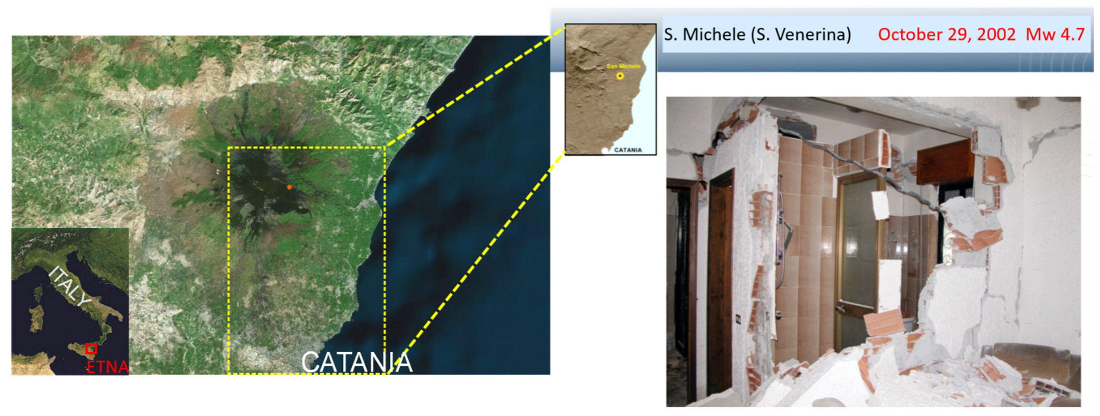
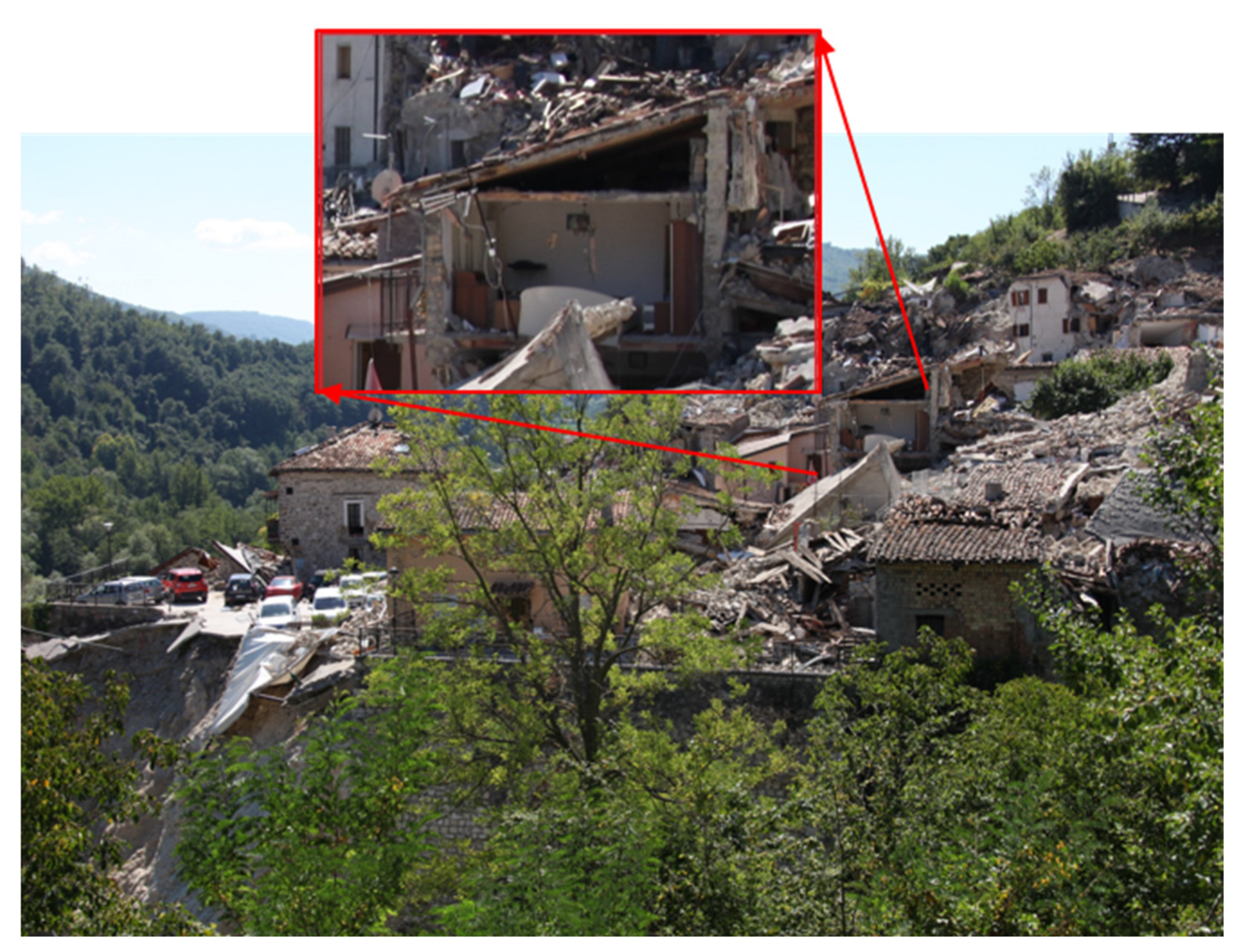
:1. Introduction
2. The Challenge: Increase Resiliency
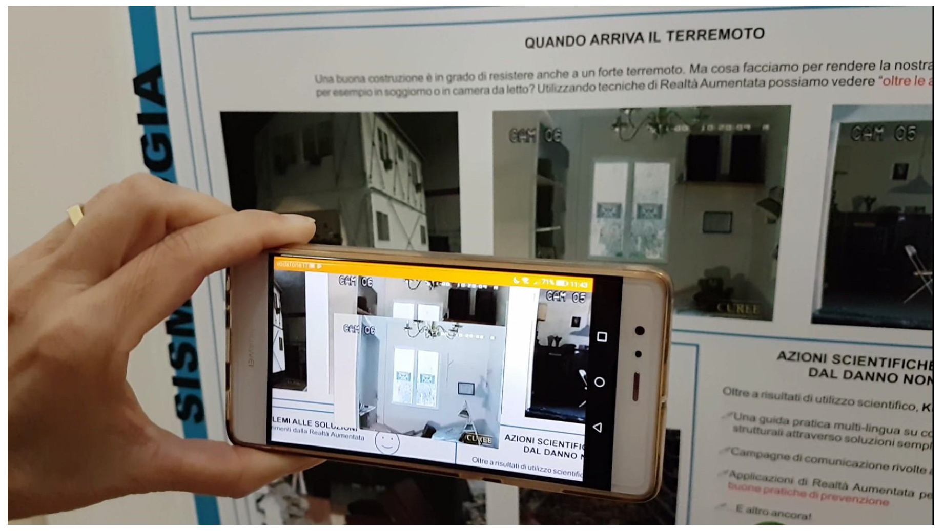
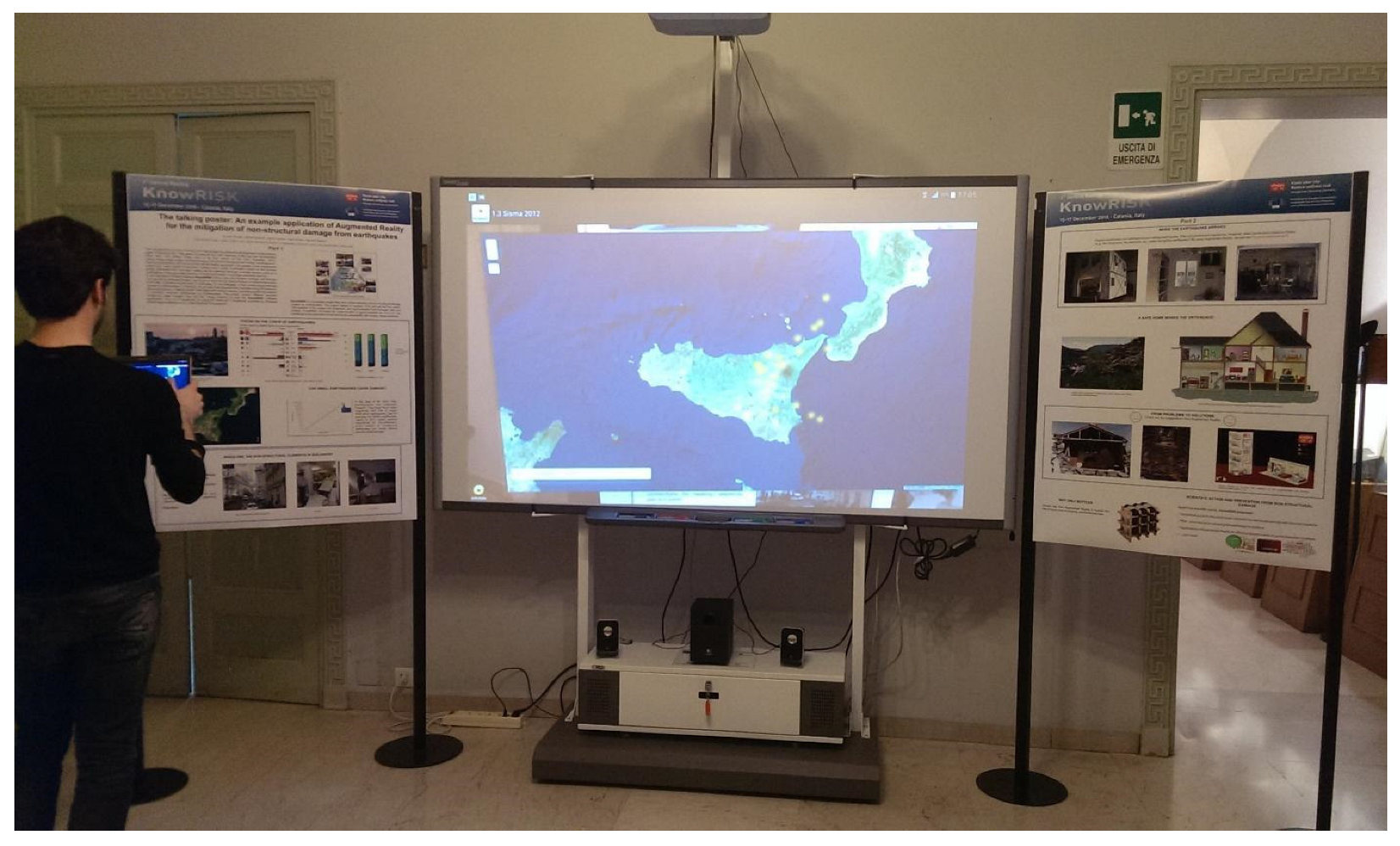
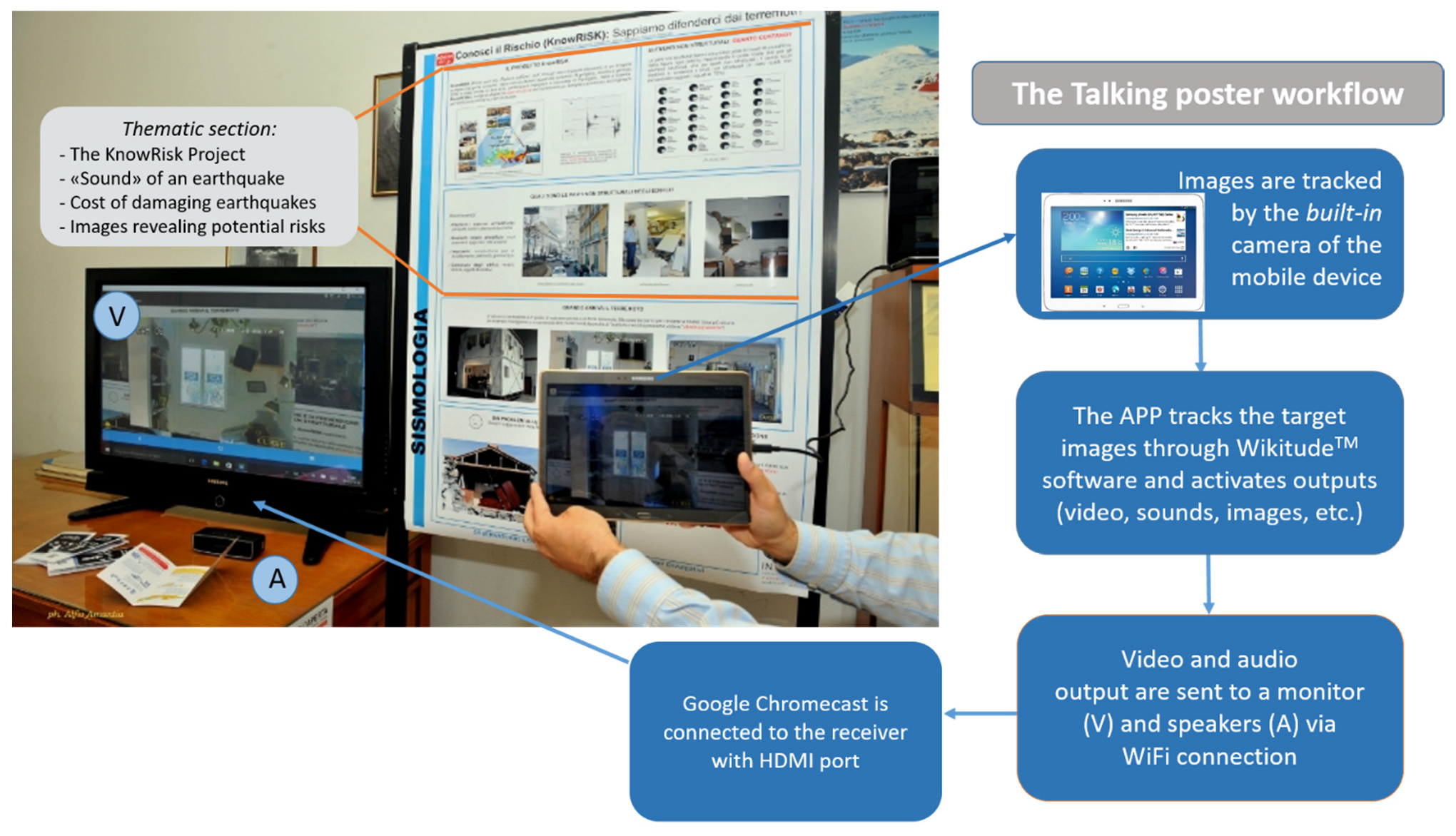
3. The Talking Poster
4. Communication and Related Perceptions of Seismic Hazard and Risk
5. Method: How AR Works in Our Apps
- A mobile device (smartphone, tablet) with a camera: the front-end device and run by the presenter of the exhibition or end users;
- An object identification system (for target identification): in the talking poster, images were typically tracked as main targets; they provided details, videos, and sounds;
- A display (a digital interactive whiteboard, DIW, or large monitor for groups of people): to let the audience be an active part of the presentation, the monitor or DIW showed in real time what the smartphone or tablet was capturing and revealing by adding the scene with AR media outputs;
- A Chromecast (optional, an access point, TP-Link™ router wireless, for Android Wi-Fi streaming): the Google Chromecast with its software enabled the connection between devices and duplicated the information streamed by the smartphone;
- A sound system: speakers completed the hardware in order to share the sounds with the whole audience.
6. Discussion
7. Conclusions
Supplementary Materials
Author Contributions
Funding
Data Availability Statement
Acknowledgments
Conflicts of Interest
References
- Xie, Y.; Ebad Sichani, M.; Padgett, J.E.; Desroches, R. The promise of implementing machine learning in earthquake engineering: A state-of-the-art review. Earthq. Spectra 2020, 36, 1769–1801. [Google Scholar] [CrossRef]
- Lovreglio, R.; Gonzalez, V.; Feng, Z.; Amor, R.; Spearpoint, M.; Thomas, J.; Trotter, M.; Sacks, R. Prototyping virtual reality serious games for building earthquake preparedness: The Auckland City Hospital case study. Adv. Eng. Inform. 2018, 38, 670–682. [Google Scholar] [CrossRef]
- Bernardini, G.; Lovreglio, R.; Quagliarini, E. Proposing behavior-oriented strategies for earthquake emergency evacuation: A behavioral data analysis from New Zealand, Italy and Japan. Saf. Sci. 2019, 116, 295–309. [Google Scholar] [CrossRef]
- Feng, Z.; González, V.A.; Trotter, M.; Spearpoint, M.; Thomas, J.; Ellis, D.; Lovreglio, R. How people make decisions during earthquakes and post-earthquake evacuation: Using Verbal Protocol Analysis in Immersive Virtual Reality. Saf. Sci. 2020, 129, 104837. [Google Scholar] [CrossRef]
- Ruggieri, S.; Cardellicchio, A.; Leggieri, V.; Uva, G. Machine-learning based vulnerability analysis of existing buildings. Autom. Constr. 2021, 132, 103936. [Google Scholar] [CrossRef]
- Zambrano, A.; Perez, I.; Palau, C.; Esteve, M. Technologies of Internet of Things applied to an Earthquake Early Warning System. Future Gener. Comput. Syst. 2017, 75, 206–215. [Google Scholar] [CrossRef]
- Wu, H.-K.; Lee, S.W.-Y.; Chang, H.-Y.; Liang, J.-C. Current status, opportunities and challenges of augmented reality in education. Comput. Educ. 2013, 62, 41–49. [Google Scholar] [CrossRef]
- Yanni, C. Creating Effective Onboarding Experiences with AR. 2018. Available online: https://www.blippar.com/blog/2018/12/07/creating-effective-onboarding-experiences-with-ar (accessed on 7 November 2018).
- Mindshare, Layered—The Future of Augmented Reality. 2018. Available online: https://www.mindshareworld.com/sites/default/files/MS-Layered-Report.pdf (accessed on 27 August 2019).
- Caudell, T.P.; Mizell, D.W. Augmented Reality: An Application of Heads-Up Display Technology to Manual Manufacturing Processes. In Proceedings of the Twenty-Fifth Hawaii International Conference on System Sciences, Kauai, HI, USA, 7–10 January 1992. [Google Scholar] [CrossRef]
- Azuma, R.T. A Survey of Augmented Reality. In Presence: Teleoperators and Virtual Environments; MIT Press: Cambridge, MA, USA, 1997; Volume 6, pp. 355–385. [Google Scholar]
- Swensen, H. Potential of Augmented Reality in sciences education—A literature review. In Proceedings of the ICERI2016 9th Annual International Conference of Education, Research and Innovation, Seville, Spain, 14–16 November 2016; ISBN 978-84-617-5895-1. [Google Scholar] [CrossRef]
- Çöltekin, A.; Lochhead, I.; Madden, M.; Christophe, S.; Devaux, A.; Pettit, C.; Lock, O.; Shukla, S.; Herman, L.; Stachoň, Z.; et al. Extended Reality in Spatial Sciences: A Review of Research Challenges and Future Directions. ISPRS Int. J. Geo-Inf. 2020, 9, 439. [Google Scholar] [CrossRef]
- CRED. Natural Disasters 2019. 2020. Available online: https://emdat.be/sites/default/files/adsr_2019.pdf (accessed on 24 January 2022).
- Azzaro, R.; D’Amico, S.; Tuvè, T.; Cascone, M. Etnean Earthquakes, Seismic Risk from Non-Structural Elements 2016; KnowRISK Project: Catania, Italy, 2016; 35p, (In English and Italian). [Google Scholar]
- FEMA. Reducing the Risks of Nonstructural Earthquake Damage—A Practical Guide; FEMA: Washington, DC, USA, 2011. Available online: https://www.fema.gov/media-library/assets/documents/21405 (accessed on 9 September 2016).
- Ferreira, M.A.; Meroni, F.; Azzaro, R.; Musacchio, G.; Rupakhety, R.; Bessason, B.; Thorvaldsdottir, S.; Lopes, M.; Oliveira, C.S.; Solarino, S. What scientific information on the seismic risk to non-structural elements do people need to know? Part 1: Compiling an inventory on damage to non-structural elements. Ann. Geophys. 2021, 64, SE321. [Google Scholar]
- Solarino, S.; Ferreira, M.A.; Musacchio, G.; Rupakhety, R.; O’Neill, H.; Falsaperla, S.; Marta, V.; Lopes, M.; Oliveira, C.S. What scientific information on non-structural elements seismic risk people need to know? Part 2: Tools for risk communication. Ann. Geophys. 2020, 64, SE322. [Google Scholar] [CrossRef]
- Ferreira, M.A.; Solarino, S.; Musacchio, G.; Mota de Sá, F.; Oliveira, C.S.; Lopes, M.; O’Neill, H.; Orlando, L.; Faggioli, M.M. KnowRISK Tools for Preparedness and Community Resilience: Practical Guide, Short Guide for Students, Portfolio and Video. In Proceedings of the 16th European Conference on Earthquake Engineering, Thessaloniki, Greece, 18–21 June 2018. [Google Scholar]
- Falsaperla, S.; Musacchio, G.; Ferreira, M.A.; Lopes, M.; Oliveira, C.S. Dissemination: Steps towards an Effective Action of Seismic Risk Reduction for Non-Structural Damage. Ann. Geophys. 2021, 63, SE328. [Google Scholar] [CrossRef]
- Peddie, J. Augmented Reality—Where We Will All Live; Springer International Publishing: Berlin/Heidelberg, Germany, 2017; p. 323. [Google Scholar] [CrossRef]
- Reitano, D.; Falsaperla, S.; Musacchio, G.; Merenda, R. Awareness on Seismic Risk: How can Augmented Reality help? In Proceedings of the International Conference on Earthquake Engineering and Structural Dynamic, Frankfurt, Germany, 8–10 February 2017; Geotechnical, Geological and Earthquake Engineering; Rupakhety, R., Olafsson, S., Bessason, B., Eds.; Springer: Cham, Switzerland, 2019; Volume 47. [Google Scholar] [CrossRef]
- EFEHR. The European Facility for Earthquake Hazard & Risk 2014. Available online: www.efehr.org (accessed on 24 January 2022).
- Crescimbene, M.; Pino, N.A.; Musacchio, G. Risk Perception and Knowledge: The Construction of the Italian Questionnaire to Assess the Effectiveness of the KnowRISK Project Actions. In Proceedings of the International Conference on Earthquake Engineering and Structural Dynamic, Frankfurt, Germany, 8–10 February 2017; Geotechnical, Geological and Earthquake Engineering; Rupakhety, R., Olafsson, S., Bessason, B., Eds.; Springer: Cham, Switzerland, 2019; Volume 47. [Google Scholar] [CrossRef]
- Musacchio, G.; Falsaperla, S.; Solarino, S.; Piangiamore, G.L.; Crescimbene, M.; Pino, N.A.; Eva, E.; Reitano, D.; Manzoli, F.; Fabbri, M.; et al. KnowRISK on Seismic Risk Communication: The Set-Up of a Participatory Strategy-Italy Case Study. In Proceedings of the International Conference on Earthquake Engineering and Structural Dynamic, Frankfurt, Germany, 8–10 February 2017; Geotechnical, Geological and Earthquake Engineering; Springer: Cham, Switzerland, 2019; Volume 47. [Google Scholar] [CrossRef]
- Platt, S.; Musacchio, G.; Crescimbene, M.; Pino, N.A.; Silva, D.S.; Ferreira, M.A.; Oliveira, C.S.; Lopes, M.; Rupakhety, R. Development of a Common (European) Tool to Assess Earthquake Risk Communication. In Proceedings of the International Conference on Earthquake Engineering and Structural Dynamic, Frankfurt, Germany, 8–10 February 2017; Geotechnical, Geological and Earthquake Engineering; Springer: Cham, Switzerland, 2019; Volume 47. [Google Scholar] [CrossRef]
- NSET. Risk Perception Survey in Bhimeshwor Municipality. In Proceedings of the 16WCEE Conference, Santiago, Chile, 9–13 January 2017; National Society for Earthquake Technology-Nepal (NSET): Lalitpur, Nepal, 2017. [Google Scholar]
- Musacchio, G.; Eva, E.; Crescimbene, M.; Pino, N.A.; Cugliari, L. A protocol to communicate seismic risk in schools: Design, test and assessment in Italy. Ann. Geophys. 2021, 63, SE325. [Google Scholar] [CrossRef]
- Silva, S.D.; Vicente, M.; Pereira, A.; Bernardo, R.; Candeias, P.; Ferreira, A.M.; Lopes, M.; Oliveira, C.S.; Henriques, P. Shaping Favorable Beliefs Towards Seismic Protection Through Risk Communication: A Pilot-Experience in Two Lisbon Schools (Portugal). In Proceedings of the International Conference on Earthquake Engineering and Structural Dynamic, Frankfurt, Germany, 8–10 February 2017; Geotechnical, Geological and Earthquake Engineering; Rupakhety, R., Olafsson, S., Bessason, B., Eds.; Springer: Cham, Switzerland, 2019; Volume 47. [Google Scholar] [CrossRef]
- Bessason, B.; Bjarnasson, J. Seismic vulnerability of low-rise residential buildings based on damage data from three earthquakes (Mw 6.5, 6.5, 6.3). Eng. Struct. 2016, 111, 64–79. [Google Scholar] [CrossRef]
- Settimana del Pianeta Terra, S. Dentro il terremoto: Percorso “animato” in realtà aumentata per la conoscenza e la riduzione dei danni non strutturali. INGV: Catania, Italy. 2017. Available online: http://www.settimanaterra.org/geoeventi-2017 (accessed on 20 October 2017).
- Falsaperla, S.; Reitano, D.; Musacchio, G.; Merenda, R. Can Building Seismic Resiliency Benefit from Emergent Technologies? Case Studies from the Projects KnowRISK and 3DTeLC. In Proceedings of the AGU Fall Meeting, San Francisco, CA, USA, 9–13 December 2019. Available online: https://agu.confex.com/agu/fm19/meetingapp.cgi/Paper/489406; http://hdl.handle.net/2122/12996 (accessed on 17 January 2020).
- Zuccarello, F.; Bilotta, G.; Cappello, A.; Ganci, G. Effusion Rates on Mt. Etna and Their Influence on Lava Flow Hazard Assessment. Remote Sens. 2022, 14, 1366. [Google Scholar] [CrossRef]
- Azzaro, R.; D’Amico, S.; Langer, H.; Meroni, F.; Squarcina, T.; Tusa, G.; Tuvè, T.; Rupakhety, R. From Seismic Input to Damage Scenario: An Example for the Pilot Area of Mt. Etna Volcano (Italy) in the KnowRISK Project. In Proceedings of the International Conference on Earthquake Engineering and Structural Dynamic, Frankfurt, Germany, 8–10 February 2017; Geotechnical, Geological and Earthquake Engineering; Rupakhety, R., Olafsson, S., Bessason, B., Eds.; Springer: Cham, Switzerland, 2019; Volume 47. [Google Scholar] [CrossRef]
- Barberi, G.; Di Grazia, G.; Ferrari, F.; Giampiccolo, E.; Maiolino, V.; Mostaccio, A.; Musumeci, C.; Scaltrito, A.; Sciotto, M.; Tusa, G.; et al. Mt. Etna Revised Seismic Catalog from 2020 (EtnaRSC2020) (Version 1) [Data Set]; Istituto Nazionale di Geofisica e Vulcanologia (INGV): Catania, Italy, 2020. [CrossRef]
- Bernhardsdottir, A.E.; Musacchio, G.; Ferreira, M.A.; Falsaperla, S. Informal education for disaster risk reduction. Bull. Earthq. Eng. 2016, 14, 2105–2116. [Google Scholar] [CrossRef]
- Devès, M.H.; Le Texier, M.; Pécout, H.; Grasland, C. Seismic risk: The biases of earthquake media coverage. Geosci. Commun. 2019, 2, 125–141. [Google Scholar] [CrossRef] [Green Version]
- AugmentedReality.org. Smart Glasses Market Report 2015. Available online: https://www.augmentedreality.org/smart-glasses-report (accessed on 23 September 2021).


Publisher’s Note: MDPI stays neutral with regard to jurisdictional claims in published maps and institutional affiliations. |
© 2022 by the authors. Licensee MDPI, Basel, Switzerland. This article is an open access article distributed under the terms and conditions of the Creative Commons Attribution (CC BY) license (https://creativecommons.org/licenses/by/4.0/).
Share and Cite
Falsaperla, S.; Reitano, D.; Musacchio, G. Augmented Reality in Seismic Risk Management: A Contribution to the Reduction of Non-Structural Damage. Geosciences 2022, 12, 332. https://doi.org/10.3390/geosciences12090332
Falsaperla S, Reitano D, Musacchio G. Augmented Reality in Seismic Risk Management: A Contribution to the Reduction of Non-Structural Damage. Geosciences. 2022; 12(9):332. https://doi.org/10.3390/geosciences12090332
Chicago/Turabian StyleFalsaperla, Susanna, Danilo Reitano, and Gemma Musacchio. 2022. "Augmented Reality in Seismic Risk Management: A Contribution to the Reduction of Non-Structural Damage" Geosciences 12, no. 9: 332. https://doi.org/10.3390/geosciences12090332
APA StyleFalsaperla, S., Reitano, D., & Musacchio, G. (2022). Augmented Reality in Seismic Risk Management: A Contribution to the Reduction of Non-Structural Damage. Geosciences, 12(9), 332. https://doi.org/10.3390/geosciences12090332