Geomorphological and Morphometric Analyses of the Catanzaro Trough (Central Calabrian Arc, Southern Italy): Seismotectonic Implications
Abstract
:1. Introduction
2. Geological Setting
2.1. Geodynamic Framework
2.2. Geological, Geomorphological, and Structural Features of the Catanzaro Trough
3. Methods and Analysis
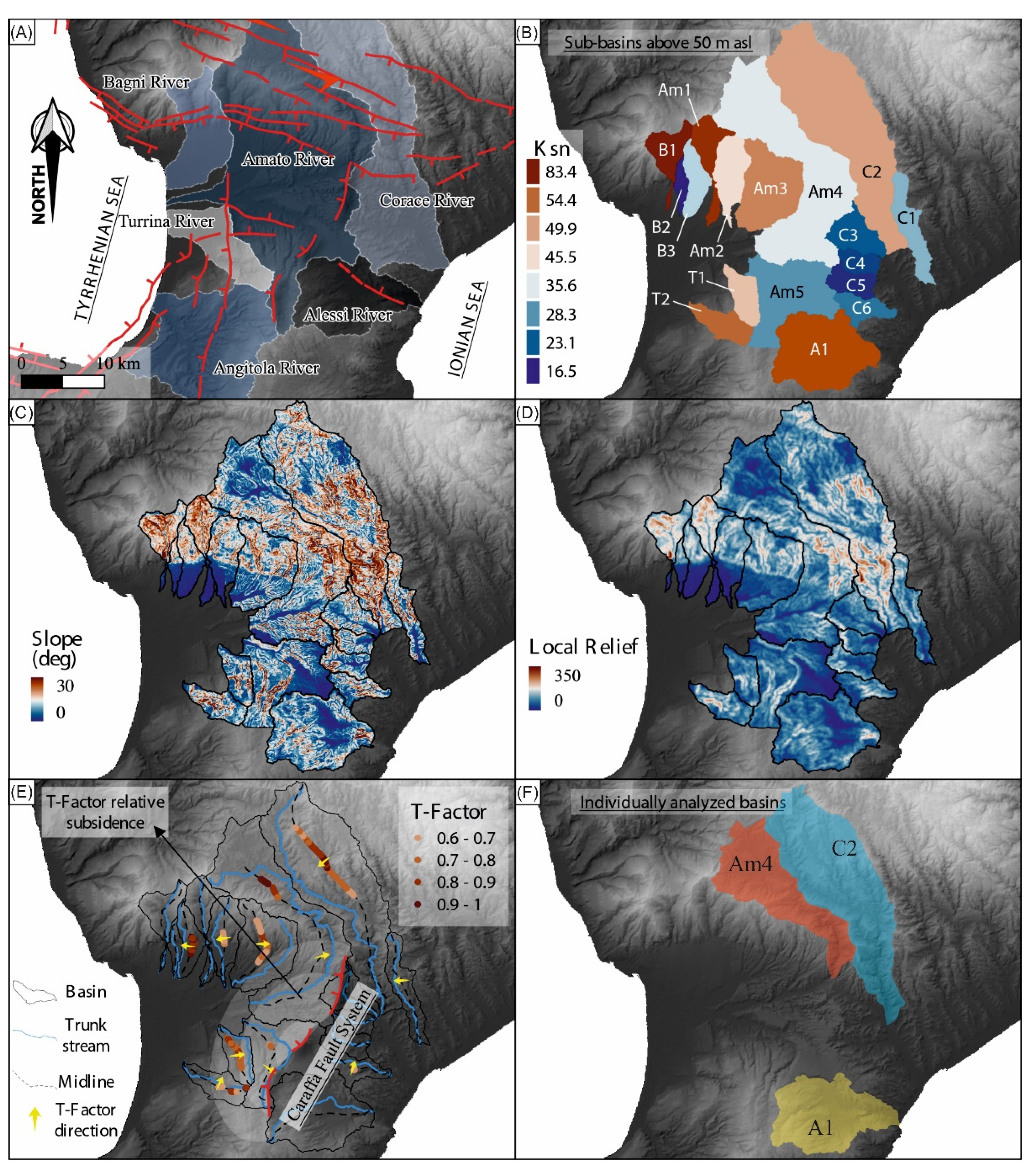
4. Geomorphological and Morphometric Evidence of Fault Activity
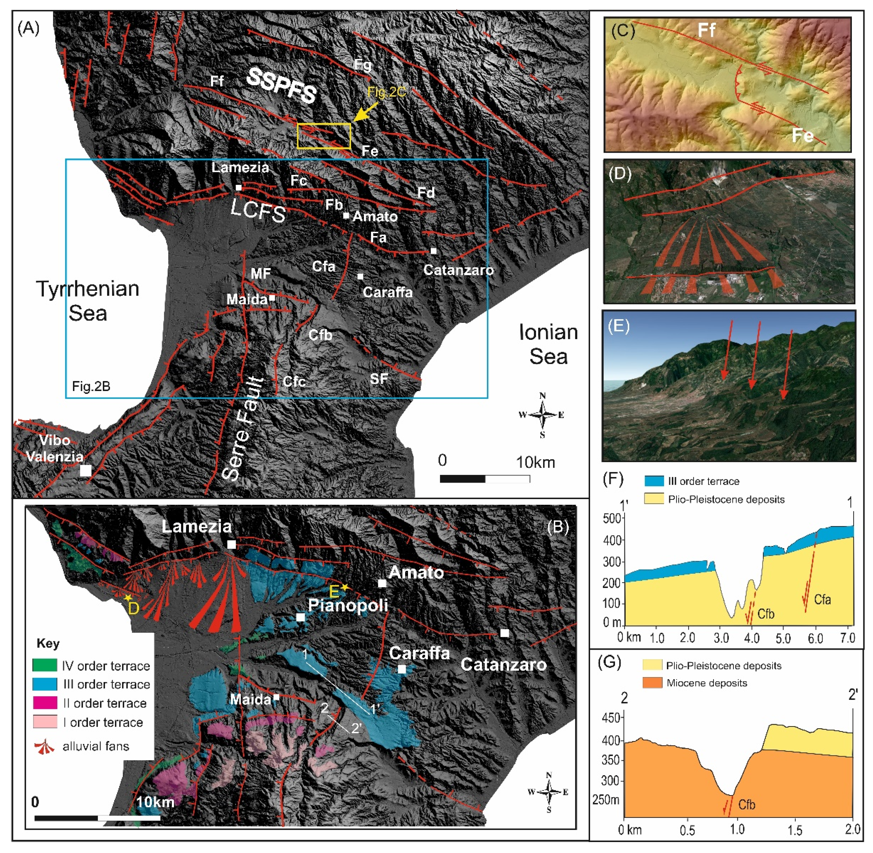
4.1. Structural Pattern
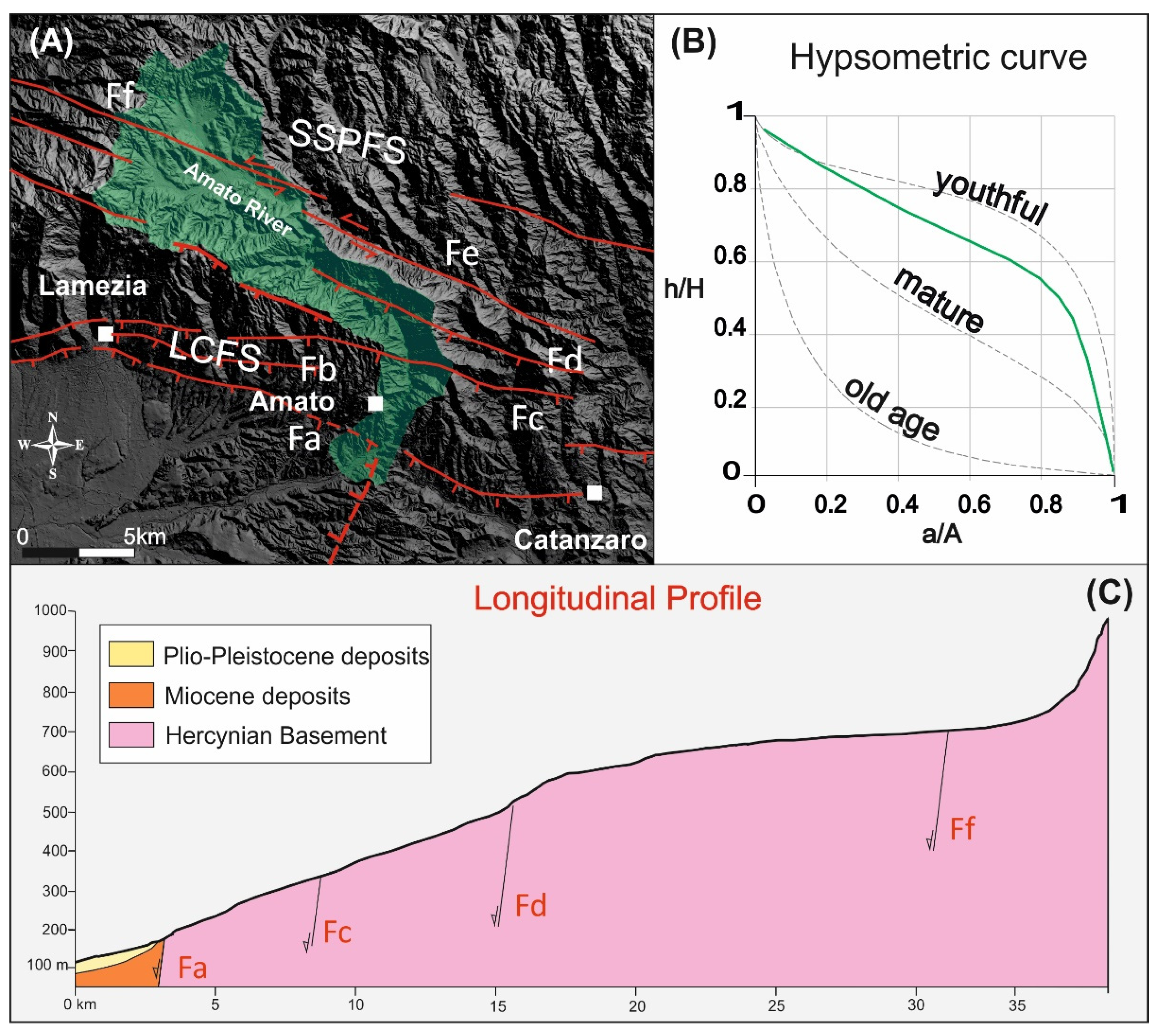
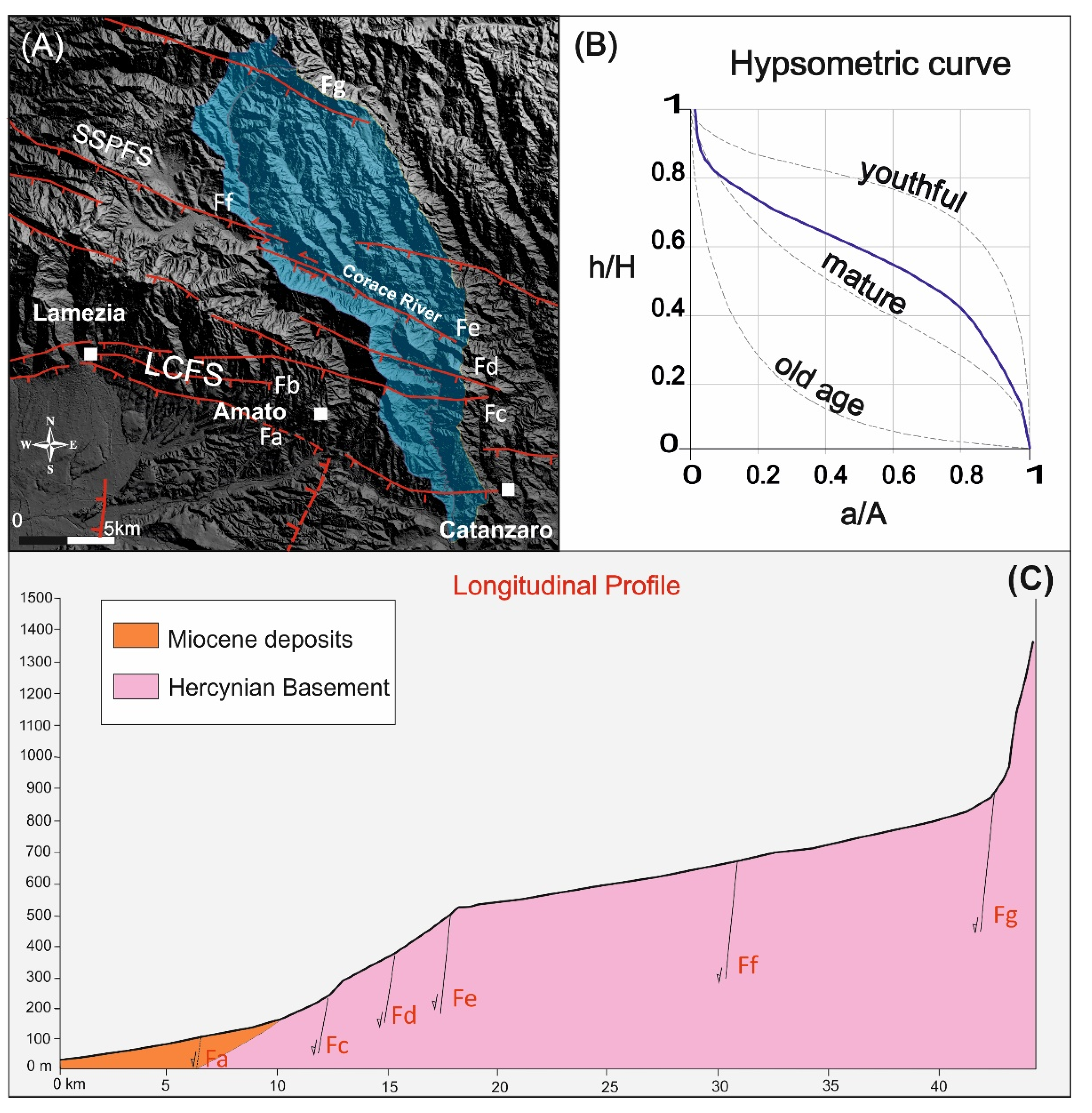
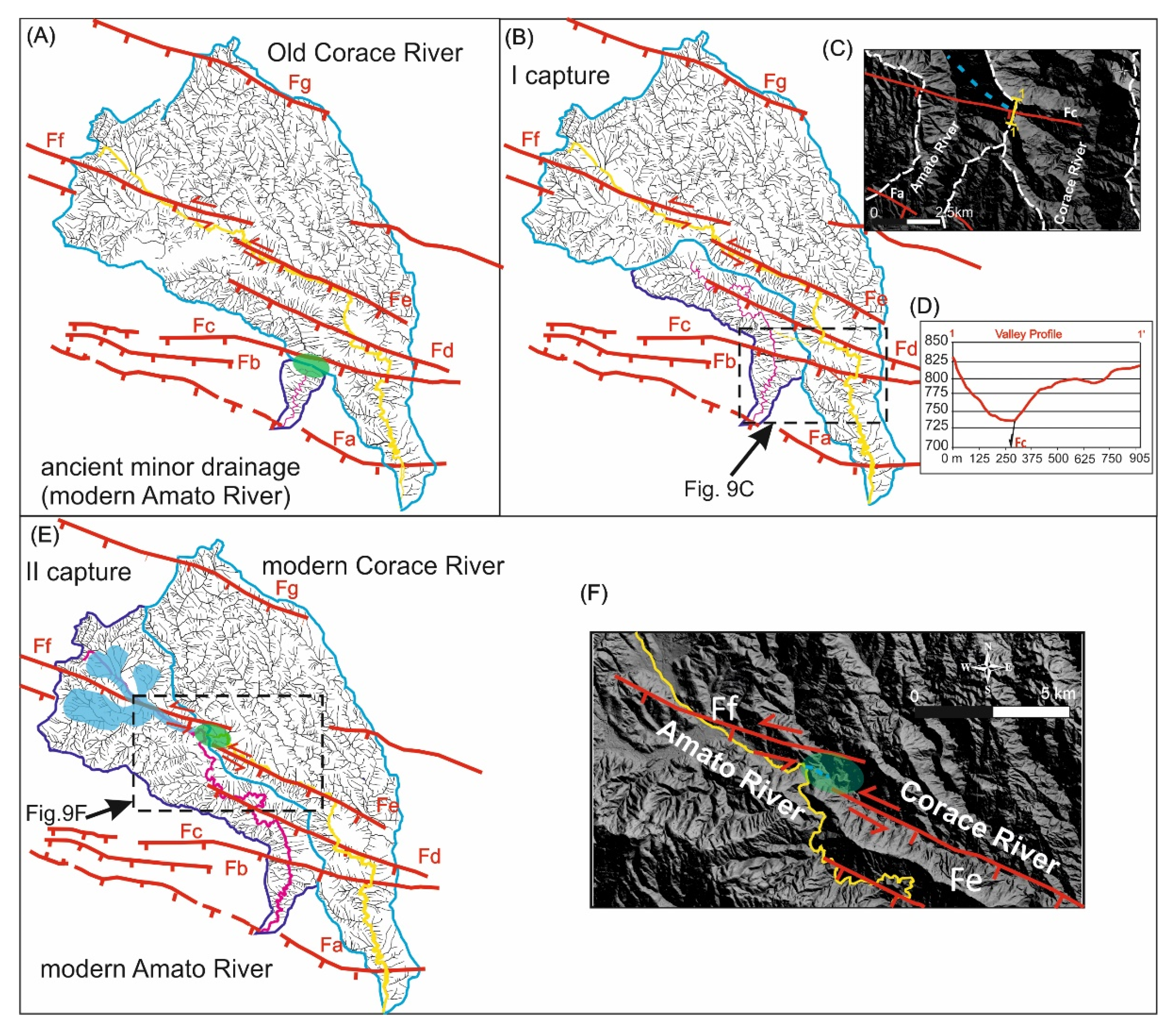
4.2. The South Sila Piccola and Lamezia–Catanzaro Fault Systems
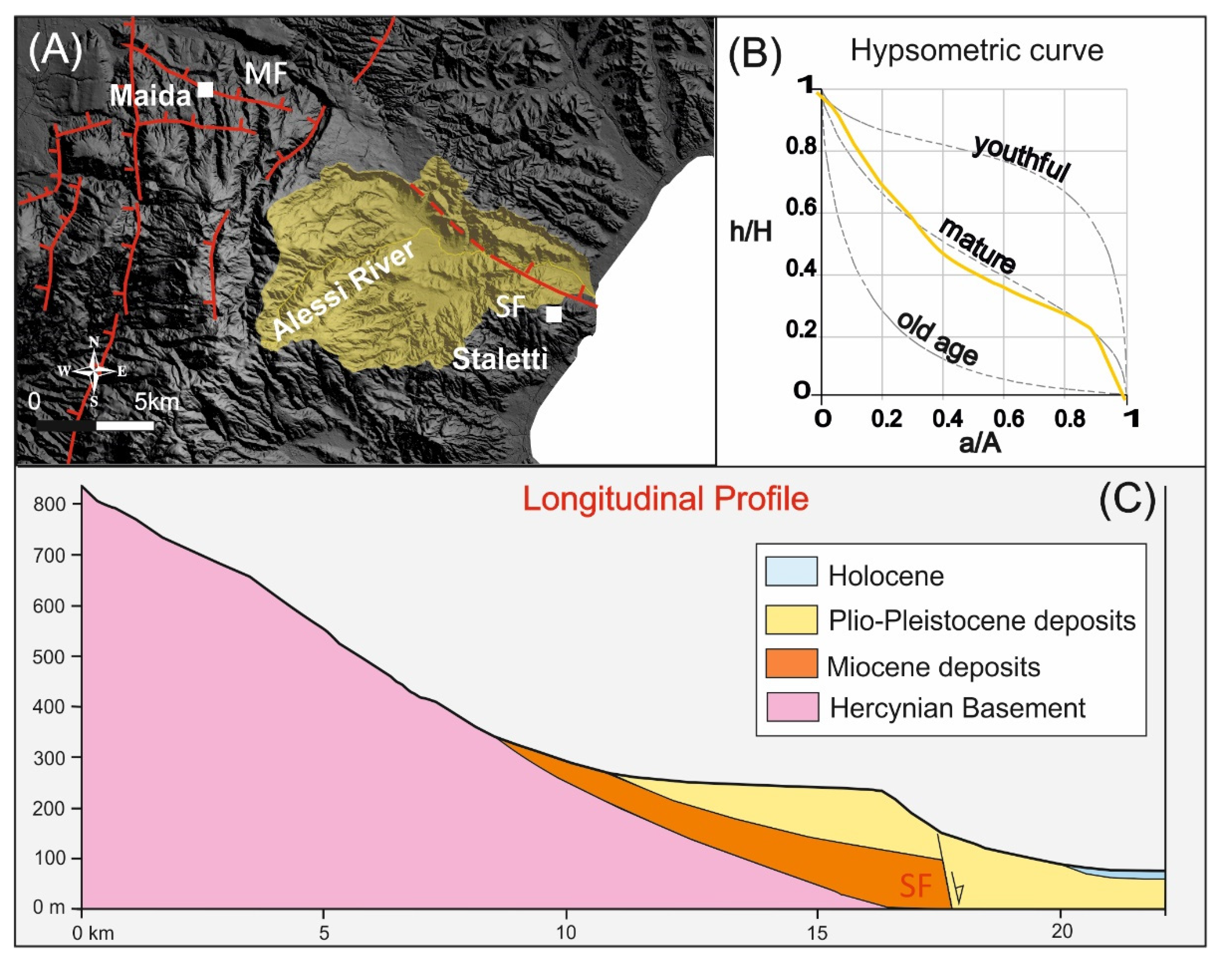
4.3. The Maida and Stalettì Faults
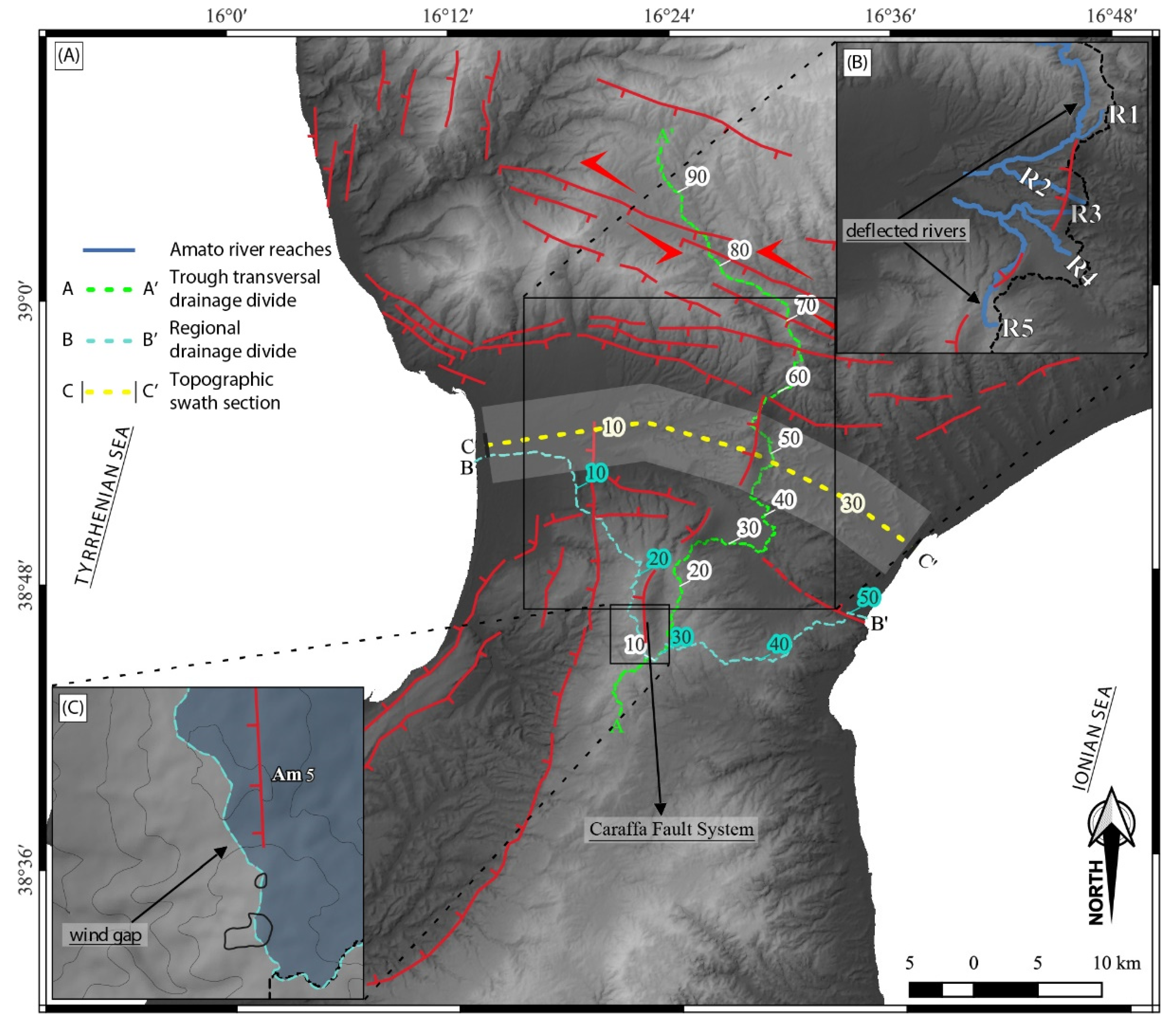
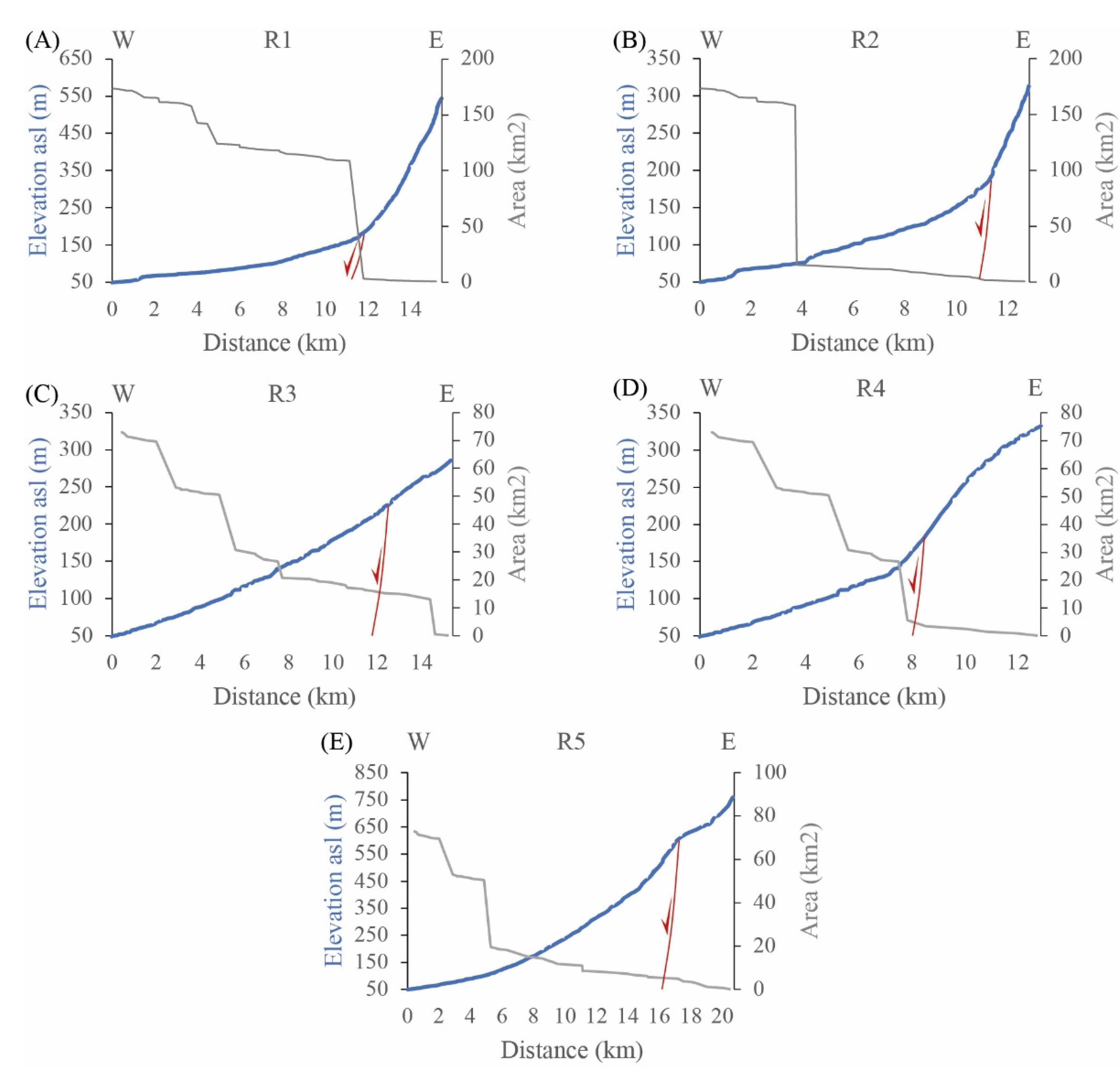
4.4. The Caraffa Fault System
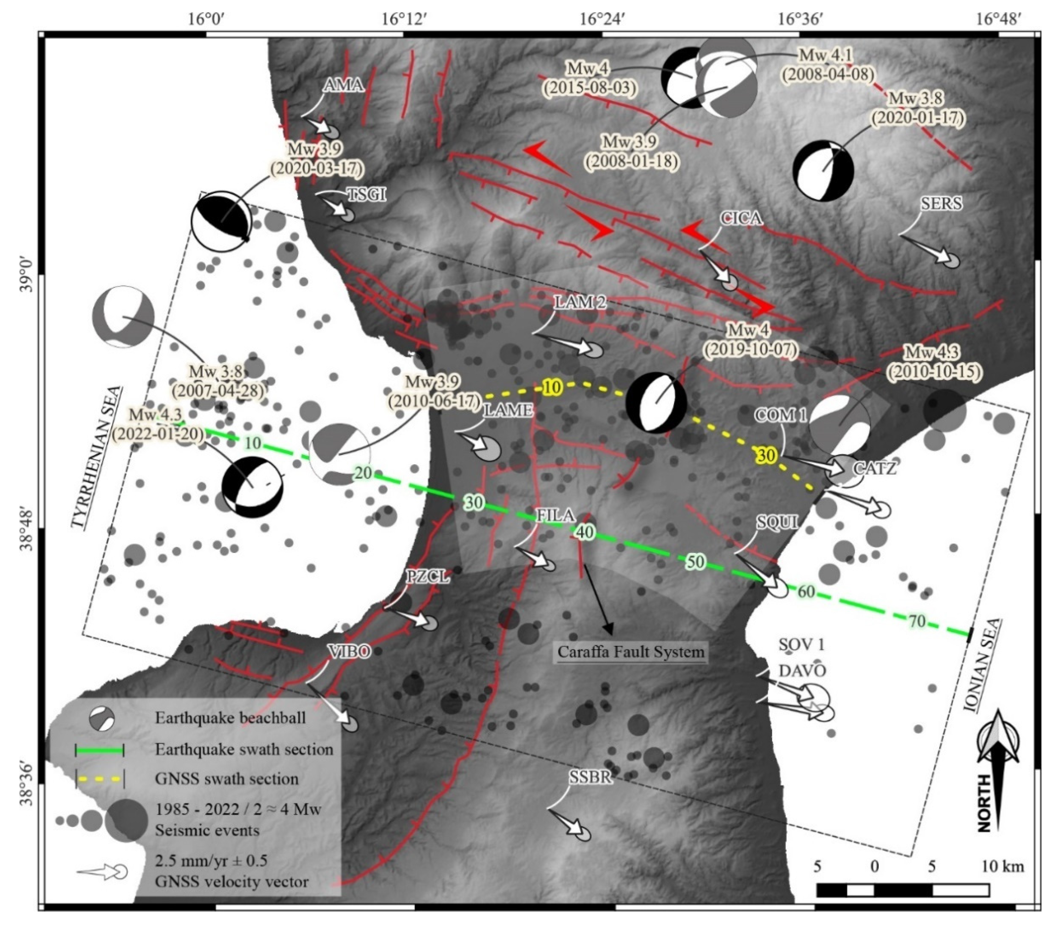
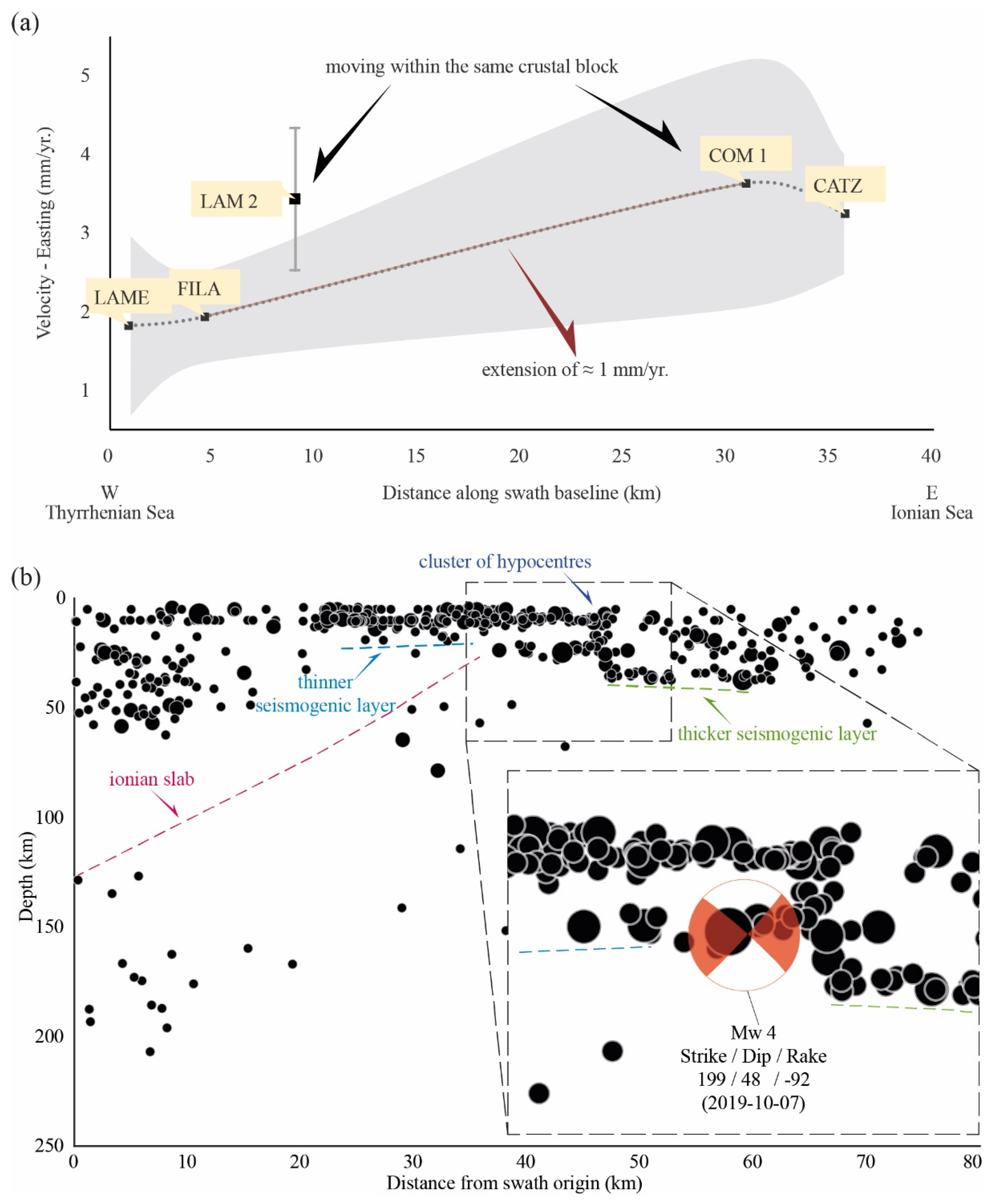
5. Seismotectonic Implications
6. Conclusions
Author Contributions
Funding
Data Availability Statement
Acknowledgments
Conflicts of Interest
References
- Ghisetti, F.; Vezzani, L. Different styles of deformation in the Calabrian arc (southern Italy): Implications for a seismotectonic zoning. Tectonophysics 1982, 85, 149–165. [Google Scholar] [CrossRef]
- Monaco, C.; Tortorici, L.; Nicolich, R.; Cernobori, L.; Costa, M. From collisional to rifted basins: An example from the southern Calabrian arc (Italy). Tectonophysics 1996, 266, 233–249. [Google Scholar] [CrossRef]
- Tortorici, L.; Monaco, C.; Tansi, C.; Cocina, O. Recent and active tectonics in the Calabrian arc (Southern Italy). Tectonophysics 1995, 243, 37–55. [Google Scholar] [CrossRef]
- Monaco, C.; Tortorici, L. Active faulting in the Calabrian arc and eastern Sicily. J. Geodyn. 2000, 29, 407–424. [Google Scholar] [CrossRef]
- Tansi, C.; Iovine, G.; Fòlino-Gallo, M. Tettonica attiva e recente, e manifestazioni gravitative profonde, lungo il bordo orientale del graben del Fiume Crati (Calabria settentrionale). Boll. Soc. Geol. Ital. 2005, 124, 563–578. [Google Scholar]
- Tansi, C.; Muto, F.; Critelli, S.; Iovine, G. Neogene-Quaternary strike-slip tectonics in the central Calabria Arc (southern Italy). J. Geodyn. 2007, 43, 397–414. [Google Scholar] [CrossRef]
- Van Dijk, J.P.; Bello, M.; Brancaleoni, G.P.; Cantarella, G.; Costa, V.; Frixa, A.; Golfetto, F.; Merlini, S.; Riva, M.; Torricelli, S.; et al. A regional structural model for the northern sector of the Calabrian Arc (southern Italy). Tectonophysics 2000, 324, 267–320. [Google Scholar] [CrossRef]
- Brutto, F.; Muto, F.; Loreto, M.F.; De Paola, N.; Tripodi, V.; Critelli, S.; Facchin, L. The Neogene-Quaternary geodynamic evolution of the central Calabrian Arc: A case study from the western Catanzaro Trough basin. J. Geodyn. 2016, 102, 95–114. [Google Scholar] [CrossRef]
- Pirrotta, C.; Barberi, G.; Barreca, G.; Brighenti, F.; Carnemolla, F.; De Guidi, G.; Monaco, C.; Pepe, F.; Scarfì, L. Recent Activity and Kinematics of the Bounding Faults of the Catanzaro Trough (Central Calabria, Italy): New Morphotectonic, Geodetic and Seismological Data. Geosciences 2021, 11, 405. [Google Scholar] [CrossRef]
- Punzo, M.; Cianflone, G.; Cavuoto, G.; De Rosa, R.; Dominici, R.; Gallo, P.; Lirer, F.; Pelosi, N.; Di Fiore, V. Active and passive seismic methods to explore areas of active faulting. The case of Lamezia Terme (Calabria, southern Italy). J. Appl. Geophys. 2021, 188, 104316. [Google Scholar] [CrossRef]
- Moretti, A. Il Database delle Faglie Capaci della Calabria: Stato Attuale delle Conoscenze. In Progetto 5.1.2 Inventario delle Faglie Attive e dei Terremoti ad Esse Associabili; Università della Calabria: Rende, Italy, 1999; Available online: https://emidius.mi.ingv.it/GNDT/P512/UR_UNICS.html (accessed on 15 July 2022).
- Gullà, G.; Antronico, L.; Sorriso-Valvo, M.; Tansi, C. Proposta metodologica per la valutazione di indicatori di pericolo e rischio da frana a scala intermedia: L’area della Stretta di Catanzaro (Calabria, Italia). Geol. Romana 2005, 38, 97–112. [Google Scholar]
- Akinci, A.; Vannoli, P.; Falcone, G.; Taroni, M.; Tiberti, M.M.; Murru, M.; Burrato, P.; Mariucci, M.T. When time and faults matter: Towards a time-dependent probabilistic SHA in Calabria, Italy. Bull. Earthq. Eng. 2017, 15, 2497–2524. [Google Scholar] [CrossRef]
- Rovida, A.; Locati, M.; Camassi, R.; Lolli, B.; Gasperini, P.; Antonucci, A. Italian Parametric Earthquake Catalogue (CPTI15), Version 3.0; Istituto Nazionale di Geofisica e Vulcanologia (INGV): Roma, Italy, 2021. [Google Scholar] [CrossRef]
- DISS Working Group. Database of Individual Seismogenic Sources (DISS), Version 3.3.0: A Compilation of Potential Sources for Earthquakes Larger than M 5.5 in Italy and Surrounding Areas; Istituto Nazionale di Geofisica e Vulcanologia (INGV): Roma, Italy, 2021. [Google Scholar]
- Cox, R.T. Analysis of drainage basin symmetry as a rapid technique to identify areas of possible Quaternary tilt-block tectonics: An example from the Mississippi Embayment. Geol. Soc. Am. Bull. 1994, 106, 571–581. [Google Scholar] [CrossRef]
- Burrato, P.; Ciucci, F.; Valensise, G. An inventory of river anomalies in the Po Plain, Northern Italy: Evidence for active blind thrust faulting. Ann. Geophys. 2003, 46, 865–882. [Google Scholar] [CrossRef]
- Hare, P.W.; Gardner, T.W. Geomorphic indicators of vertical neotectonism along converging plate margins, Nicoya Peninsula, Costa Rica. In Tectonic Geomorphology, Proceedings of the 15th Annual Binghamton Geomorphology Symposium, September 1984; Morisawa, M., Pantosti, D., Eds.; Allen & Unwin: Boston, MA, USA, 1985; pp. 123–134. [Google Scholar]
- Valensise, G.; Pantosti, D. The investigation of potential earthquake sources in peninsular Italy: A review. J. Seismol. 2001, 5, 287–306. [Google Scholar] [CrossRef]
- Snyder, N.P.; Whipple, K.X.; Tucker, G.E.; Merritts, D.J. Landscape response to tectonic forcing: Digital elevation model analysis of stream profiles in the Mendocino triple junction region, northern California. Geol. Soc. Am. Bull. 2000, 112, 1250–1263. [Google Scholar] [CrossRef]
- Whipple, K.X. Bedrock rivers and the geomorphology of active orogens. Annu. Rev. Earth Planet. Sci. 2004, 32, 151–185. [Google Scholar] [CrossRef]
- Guarnieri, P.; Pirrotta, C. The response of drainage basins to the late Quaternary tectonics in the Sicilian side of the Messina Strait (NE Sicily). Geomorphology 2008, 95, 260–273. [Google Scholar] [CrossRef]
- Pedrera, A.; Pérez-Peña, J.V.; Galindo-Zaldívar, J.; Azañón, J.M.; Azor, A. Testing the sensitivity of geomorphic indices in areas of low-rate active folding (eastern Betic Cordillera, Spain). Geomorphology 2009, 105, 218–231. [Google Scholar] [CrossRef]
- Figueroa, A.M.; Knott, J.R. Tectonic geomorphology of the southern Sierra Nevada Mountains (California): Evidence for uplift and basin formation. Geomorphology 2010, 123, 34–45. [Google Scholar] [CrossRef]
- Demoulin, A. Basin and river profile morphometry: A new index with a high potential for relative dating of tectonic uplift. Geomorphology 2011, 126, 97–107. [Google Scholar] [CrossRef] [Green Version]
- Camafort, M.; Pérez-Peña, J.V.; Booth-Rea, G.; Melki, F.; Gràcia, E.; Azañón, J.M.; Galve, J.P.; Marzougui, W.; Gaidi, S.; Ranero, C.R. Active tectonics and drainage evolution in the Tunisian Atlas driven by interaction between crustal shortening and mantle dynamics. Geomorphology 2020, 351, 106954. [Google Scholar] [CrossRef]
- Pirrotta, C.; Barbano, M.S. New Macroseismic and Morphotectonic Constraints to Infer a Fault Model for the 9 (Mw6.1) and 11 January (Mw7.3) 1693 Earthquakes (Southeastern Sicily). Front. Earth Sci. 2020, 8, 550851. [Google Scholar] [CrossRef]
- Molin, P.; Pazzaglia, F.J.; Dramis, F. Geomorphic expression of the active tectonics in a rapidly-deforming forearc, Sila Massif, Calabria, Southern Italy. Am. J. Sci. 2004, 304, 559–589. [Google Scholar] [CrossRef]
- Pirrotta, C.; Barbano, M.S.; Monaco, C. Evidence of active tectonics in Southern Calabria (Italy) by geomorphic analysis: The examples of the Catona and Petrace rivers. Ital. J. of Geosci. 2016, 135, 142–156. [Google Scholar] [CrossRef]
- Roda-Boluda, D.C.; Whittaker, A.C. Structural and geomorphological constraints on active normal faulting and landscape evolution in Calabria, Italy. J. Geol. Soc. 2017, 174, 701–720. [Google Scholar] [CrossRef]
- Carminati, E.; Wortel, M.J.R.; Spakman, W.; Sabadini, R. The role of slab detachment processes in the opening of the western–central Mediterranean basins: Some geological and geophysical evidence. Earth Planet. Sci. Lett. 1998, 160, 651–665. [Google Scholar] [CrossRef]
- Faccenna, C. Constraints on mantle circulation around the deforming Calabrian slab. Geophys. Res. Lett. 2005, 32, L06311. [Google Scholar] [CrossRef]
- Carminati, E.; Doglioni, C. Mediterranean tectonics. In Encyclopedia of Geology; Selley, R.C., Robin, L., Cocks, M., Plimer, I.R., Eds.; Elsevier Academic Press: Cambridge, MA, USA, 2005; pp. 135–146. [Google Scholar]
- Guarnieri, P. Plio-Quaternary segmentation of the south Tyrrhenian forearc basin. Int. J. Earth Sci. (Geol. Rundsch.) 2006, 95, 107–118. [Google Scholar] [CrossRef]
- Pepe, F.; Bertotti, G.; Ferranti, L.; Sacchi, M.; Collura, A.M.; Passaro, S.; Sulli, A. Pattern and rate of post-20 ka vertical tectonic motion around the Capo Vaticano Promontory (W Calabria, Italy) based on offshore geomorphological indicators. Quat. Int. 2014, 332, 85–98. [Google Scholar] [CrossRef]
- Tiberti, M.M.; Vannoli, P.; Fracassi, U.; Burrato, P.; Kastelic, V.; Valensise, G. Understanding seismogenic processes in the Southern Calabrian Arc: A geodynamic perspective. Ital. J. Geosci. 2017, 136, 365–388. [Google Scholar] [CrossRef] [Green Version]
- De Ritis, R.; Pepe, F.; Orecchio, B.; Casalbore, D.; Bosman, A.; Chiappini, M.; Chiocci, F.; Corradino, M.; Nicolich, R.; Martorelli, E.; et al. Magmatism along lateral slab-edges: Insights from the Diamante-Enotrio-Ovidio Volcanic-Intrusive Complex (Southern Tyrrhenian Sea). Tectonics 2019, 38, 2581–2605. [Google Scholar] [CrossRef]
- Corradino, M.; Pepe, F.; Bertotti, G.; Picotti, V.; Monaco, C.; Nicolich, R.; et al. 3-D Architecture and Plio-Quaternary Evolution of the Paola Basin: Insights into the Forearc of the Tyrrhenian-Ionian Subduction System. Tectonics 2020, 39, e2019TC005898. [Google Scholar] [CrossRef]
- Corradino, M.; Pepe, F.; Burrato, P.; Kanari, M.; Parrino, N.; Bertotti, G.; Bosman, A.; Casalbore, D.; Ferranti, L.; Martorelli, E. An integrated multiscale method for the characterisation of active faults in offshore areas. The case of Sant’Eufemia Gulf (Offshore Calabria, Italy). Front. Earth Sci. 2021, 9, 670557. [Google Scholar] [CrossRef]
- Wortel, R.; Spakman, W. Subduction and slab detachment in the Mediterranean-Carpathian region. Science 2000, 290, 1910–1917. [Google Scholar] [CrossRef]
- Orecchio, B.; Presti, D.; Totaro, C.; Neri, G. What earthquakes say concerning residual subduction and STEP dynamics in the Calabrian Arc region, south Italy. Geophys. J. Intern. 2014, 199, 1929–1942. [Google Scholar] [CrossRef]
- Maesano, F.E.; Tiberti, M.M.; Basili, R. The Calabrian Arc: Three-dimensional modelling of the subduction interface. Sci. Rep. 2017, 7, 8887. [Google Scholar] [CrossRef]
- Scarfì, L.; Barberi, G.; Barreca, G.; Cannavò, F.; Koulakov, I.; Patanè, D. Slab narrowing in the Central Mediterranean: The Calabro-Ionian subduction zone as imaged by high resolution seismic tomography. Sci. Rep. 2018, 8, 5178. [Google Scholar] [CrossRef]
- Barreca, G.; Scarfì, L.; Gross, F.; Monaco, C.; De Guidi, G. Fault pattern and seismotectonic potential at the south-western edge of the Ionian Subduction system (southern Italy): New field and geophysical constraints. Tectonophysics 2019, 761, 31–45. [Google Scholar] [CrossRef]
- Westaway, R. Quaternary uplift of southern Italy. J. Geophys. Res. 1993, 98, 741–772. [Google Scholar] [CrossRef]
- Doglioni, C.; Innocenti, F.; Mariotti, G. Why Mt. Etna? Terra Nova 2001, 13, 25–31. [Google Scholar] [CrossRef] [Green Version]
- Miyauchi, T.; Dai Pra, G.; Labini, S.S. Geochronology of Pleistocene marine terraces and regional tectonics in the Tyrrhenian coast of south Calabria, Italy. Il Quat. 1994, 7, 17–34. [Google Scholar]
- Monaco, C.; Barreca, G.; Di Stefano, A. Quaternary marine terraces and fault activity in the northern mainland sectors of the Messina Straits (southern Italy). Ital. J. Geosci. 2017, 136, 337–346. [Google Scholar] [CrossRef]
- Amodio Morelli, L.; Bonardi, G.; Colonna, V.; Dietrich, D.; Giunta, G.; Ippolito, F.; Liguori, V.; Lorenzoni, S.; Paglionico, A.; Perrone, V.; et al. L’Arco Calabro-Peloritano nell’orogene Appenninico-Maghrebide. Mem. Della Soc. Geol. Ital. 1976, 17, 1–60. [Google Scholar]
- Zecchin, M.; Praeg, D.; Ceramicola, S.; Muto, F. Onshore to offshore correlation of regional unconformities in the Plio-Pleistocene sedimentary successions of the Calabrian Arc (central Mediterranean). Earth Sci. Rev. 2015, 142, 60–78. [Google Scholar] [CrossRef]
- Ouchi, S. Response of alluvial rivers to slow active tectonic movement. Geol. Soc. Am. Bull. 1985, 96, 504–515. [Google Scholar] [CrossRef]
- Parrino, N.; Pepe, F.; Burrato, P.; Dardanelli, G.; Corradino, M.; Pipitone, C.; Gasparo Morticelli, M.; Sulli, A.; Di Maggio, C. Elusive active faults in a low strain rate region (Sicily, Italy): Hints from a multidisciplinary land-to-sea approach. Tectonophysics 2022, 839, 229520. [Google Scholar] [CrossRef]
- O’Callaghan, J.F.; Mark, D.M. The extraction of drainage networks from digital elevation data. Comput. Vis. Graph. Image Process. 1984, 28, 323–344. [Google Scholar] [CrossRef]
- ISIDe Working Group. Italian Seismological Instrumental and Parametric Database (ISIDe). Istituto Nazionale di Geofisica e Vulcanologia (INGV): Roma, Italy, 2007. [Google Scholar] [CrossRef]
- Horton, R. E. Erosional development of streams and their drainage basins. Hydro-physical approach to quantitative morphology. Geol. Soc. of Am. Bull. 1945, 56, 275–370. [Google Scholar] [CrossRef]
- Strahler, A.N. Hypsometric (area-altitude) analysis of erosional topography. Geol. Soc. Am. Bull. 1952, 63, 1117–1142. [Google Scholar] [CrossRef]
- Avena, G.C.; Giuliano, G.; Lupia Palmieri, E. Sulla valutazione quantitativa della gerarchizzazione ed evoluzione dei reticoli fluviali. Boll. Soc. Geol. Ital. 1967, 86, 781–796. [Google Scholar]
- Pinter, N. Applications of tectonic geomorphology for deciphering active deformation in the Pannonian Basin Hungary. In Proceedings of the Workshop on Applications of GPS in Plate Tectonics in Research on Fossil Energy Resources and in Earthquake Hazard Assessment; Fodor, L., Brezsnyánszky, K., Eds.; Occasional Papers of the Geological Institute of Hungary; Magyar Állami Földtani Intézet: Budapest, Hungary, 2005; Volume 204, pp. 25–51. [Google Scholar]
- Bull, W.B.; McFadden, L. Tectonic geomorphology north and south of the Garlock Fault, California. In Geomorphology in Arid Regions; Doering, D.O., Ed.; State University of New York: Binghamton, NY, USA, 1977; pp. 115–138. [Google Scholar]
- Woolderink, H.A.G.; Cohen, K.M.; Kasse, C.; Kleinhans, M.G.; Van Balen, R.T. Patterns in river channel sinuosity of the Meuse, Roer and Rhine rivers in the Lower Rhine Embayment rift-system, are they tectonically forced? Geomorphology 2021, 375, 107550. [Google Scholar] [CrossRef]
- Kirby, E.; Whipple, K.X. Expression of active tectonics in erosional landscapes. J. Struct. Geol. 2012, 44, 54–75. [Google Scholar] [CrossRef]
- Wobus, C.; Whipple, K.X.; Kirby, E.; Snyder, N.; Johnson, J.; Spyropolou, K.; Crosby, B.; Sheehan, D. Tectonics from topography: Procedurses, promise, and pitfalls. Geol. Soc. Am. Spec. Pap. 2006, 398, 55–74. [Google Scholar] [CrossRef]
- Cassa per il Mezzogiorno. Carta Geologica della Calabria. Tav. Decollatura; Scale 1:25,000; Poligrafica & Cartevalori: Napoli, Italy, 1969. [Google Scholar]
- Wells, D.; Coppersmith, K. New empirical relationships among magnitude, rupture length, rupture width, rupture area, and surface displacement. Bull. Seismol. Soc. Am. 1994, 84, 974–1002. [Google Scholar]
- Boncio, P.; Lavecchia, G.; Pace, B. Defining a model of 3D seismogenic sources for seismic hazard assessment applications: The case of central Apennines (Italy). J. Seismol. 2004, 8, 407–425. [Google Scholar] [CrossRef]
- Jacques, E.; Monaco, C.; Tapponnier, P.; Tortorici, L.; Winter, T. Faulting and earthquake triggering during the 1783 Calabria seismic sequence. Geophys. J. Int. 2001, 147, 499–516. [Google Scholar] [CrossRef] [Green Version]


| Hierarchical Parameters | Description | References |
|---|---|---|
| Strahler order | It indicates the phase of maturity of the hydrographic network. The hierarchical number is the highest order of the stream network. | [55,56] |
| Bifurcation ratio | It describes the degree of branching of the hydrographic network and highlights possible hierarchical anomalies. Rb (u − u + 1) = Nu/Nu + 1 Nu is the number of fluvial segments of a given order; Nu + 1 is the number of fluvial segments of the immediately higher order. | [55,56,57] |
| Direct bifurcation ratio | It describes the degree of branching of the hydrographic network and highlights possible hierarchical anomalies. Rbd = Ndu/Nu + 1 Ndu represents the number of fluvial segments of a given order that flow into higher-order segments; Nu + 1 is the number of segments of the next higher order. | |
| Bifurcation index (R) | It describes the degree of branching of the hydrographic network and highlights possible hierarchical anomalies. R = Rb − Rdb Rb encompasses all the segments of a given order, including the anomalous drainage, while Rbd considers only the non-anomalous segments. For a well-organized basin, (Rb ≈ Rbd) R must approach zero; on the contrary, high R values indicate that the fluvial network does not have an excellent hierarchical organization. | |
| Anomaly parameter | It indicates the fluvial anomalies. An i.e., a river segment of a given order u flowing into a segment of order u + 2. It is calculated for each u order. | [57] |
| Geomorphic Indexes | Description | Reference |
| Asymmetry factor | It allows the evaluation of the asymmetry of the basin. AF = 100 (Ar/At) where Ar is the basin area on the hydrographic right to the main river trunk segment; At is the area of the entire drainage basin. AF value greater than 50 indicates shifting towards the hydrographic left, whereas a value lower than 50 indicates rightward shifting. | [16,18,28,58] |
| Transverse topographic symmetry factor | It allows the evaluation of the asymmetry of the basin. T = Da/Dd where Da is the distance from the main river trunk to the basin midline; Dd is the distance from the basin watershed to the basin midline. Low T values indicate stability (Da approaches zero); on the contrary, T values approaching one indicate basin asymmetry and, thus, tilting. | [16] |
| Basin elongation ratio (Re) | It describes the planimetric shape of the basin and its phase of maturity and stability: a mature basin draining on a stable area has a shape similar to a circle, whereas a basin draining on an area characterized by a rapid uplift shows an elongated narrow shape. Re = (2√A:√Π)/Lb where A is the basin area; Lb is the length of the basin parallel to the main drainage line. | [28,59] |
| Sinuosity index | It indicates the response of a fluvial channel to slope steepening with a meandering sinuosity increase. S = L/Sl_Dist Sl_Dist is the straight-line distance from the catchment start point to the endpoint, and L is the total length of the line segments. The sinuosity of a straight line is 1. If the line is closed (start point equals endpoint), the sinuosity is 0. As the line becomes curvier, the sinuosity increases. | [60] and references therein |
| Hypsometric integral | It quantifies the areal distribution of the relief elevation in the basin, describing the stage of the drainage basin or part of it, if youthful, mature, or old. Hypsometric integral is measured for an interval of elevation. The relative area (a/A ratio, with A total area and the basin area above a given elevation h, and the relative elevation (h/H ratio, with H maximum basin elevation and h topographic elevation), are represented in the Cartesian graph as a curve. | [56] |
| Normalized steepness index (Ksn) |
It represents a measure of the river channel slope nor-malized to the drainage area directly proportional to the uplift rates. S represents the slope, A the drainage area, and the normalized channel concavity, set equal to 0.45, following the Kirby and Whipple (2012) approach. The normalized steepness index (Ksn) allows the comparison of stream profiles characterized by wildly varying drainage areas. Higher values indicate higher uplift rate values. | [20,61,62] |
| Am4 | Number | Rb | Rbd | R = (Rb − Rbd) | An | AF | Re | S |
|---|---|---|---|---|---|---|---|---|
| ord 1 | 742 | 5.7 | 3.7 | 1.9 | 255 | 58.40 | 0.184 | 1.62 |
| ord 2 | 131 | 4.0 | 2.8 | 1.2 | 39 | |||
| ord 3 | 33 | 3.7 | 2.6 | 1.1 | 10 | |||
| ord 4 | 9 | 4.5 | 3.5 | 1.0 | 2 | |||
| ord 5 | 2 | 2.0 | 2.0 | 0.0 | 0 | |||
| ord 6 | 1 | |||||||
| C2 | Number | Rb | Rbd | R = (Rb − Rbd) | An | AF | Re | S |
| ord 1 | 1117 | 5.6 | 3.6 | 2.0 | 395 | 25.82 | 0.171 | 1.58 |
| ord 2 | 199 | 4.6 | 3.0 | 1.6 | 68 | |||
| ord 3 | 43 | 8.6 | 6.8 | 1.8 | 9 | |||
| ord 4 | 5 | 5.0 | 5.0 | 0.0 | 0 | |||
| ord 5 | 1 | |||||||
| A1 | Number | Rb | Rbd | R = (Rb − Rbd) | An | AF | Re | S |
| ord 1 | 609 | 6.6 | 3.9 | 2.7 | 247 | 52.97 | 0.308 | 1.47 |
| ord 2 | 92 | 5.4 | 3.9 | 1.5 | 26 | |||
| ord 3 | 17 | 4.3 | 3.0 | 1.3 | 5 | |||
| ord 4 | 4 | 2.0 | 2.0 | 0.0 | 0 | |||
| ord 5 | 2 | 2.0 | 2.0 | 0.0 | 0 | |||
| ord 6 | 1 |
Publisher’s Note: MDPI stays neutral with regard to jurisdictional claims in published maps and institutional affiliations. |
© 2022 by the authors. Licensee MDPI, Basel, Switzerland. This article is an open access article distributed under the terms and conditions of the Creative Commons Attribution (CC BY) license (https://creativecommons.org/licenses/by/4.0/).
Share and Cite
Pirrotta, C.; Parrino, N.; Pepe, F.; Tansi, C.; Monaco, C. Geomorphological and Morphometric Analyses of the Catanzaro Trough (Central Calabrian Arc, Southern Italy): Seismotectonic Implications. Geosciences 2022, 12, 324. https://doi.org/10.3390/geosciences12090324
Pirrotta C, Parrino N, Pepe F, Tansi C, Monaco C. Geomorphological and Morphometric Analyses of the Catanzaro Trough (Central Calabrian Arc, Southern Italy): Seismotectonic Implications. Geosciences. 2022; 12(9):324. https://doi.org/10.3390/geosciences12090324
Chicago/Turabian StylePirrotta, Claudia, Nicolò Parrino, Fabrizio Pepe, Carlo Tansi, and Carmelo Monaco. 2022. "Geomorphological and Morphometric Analyses of the Catanzaro Trough (Central Calabrian Arc, Southern Italy): Seismotectonic Implications" Geosciences 12, no. 9: 324. https://doi.org/10.3390/geosciences12090324
APA StylePirrotta, C., Parrino, N., Pepe, F., Tansi, C., & Monaco, C. (2022). Geomorphological and Morphometric Analyses of the Catanzaro Trough (Central Calabrian Arc, Southern Italy): Seismotectonic Implications. Geosciences, 12(9), 324. https://doi.org/10.3390/geosciences12090324


