Abstract
Field exposures are often used to provide useful information about sub-surface reservoirs. This paper discusses general lessons learnt about the use of deformed Devonian and Carboniferous meta-sedimentary rocks in the Harz Mountains, Germany, as analogues for a proposed enhanced geothermal reservoir (EGS) at Göttingen. The aims of any analogue study must be clarified, including agreeing with people from other disciplines (especially reservoir modellers) about the information that can and cannot be obtained from surface exposures. Choice of an analogue may not simply involve selection of the nearest exposures of rocks of a similar age and type, but should involve consideration of such factors as the quality and geological setting of the analogue and reservoir, and of any processes that need to be understood. Fieldwork should focus on solving particular problems relating to understanding the EGS, with care being needed to avoid becoming distracted by broader geological issues. It is suggested that appropriate questions should be asked and appropriate analyses used when planning a study of a geothermal reservoir, including studies of exposed analogues.
1. Introduction
Rock exposures are commonly used as analogues to understand and make predictions about sub-surface geology. Exposed analogues have been used for a range of applications, including in the geothermal (e.g., [1]), mining (e.g., [2]), petroleum (e.g., [3]), hydrogeology (e.g., [4]), nuclear waste disposal (e.g., [5]) and carbon sequestration (e.g., [6]) industries. Many of these applications require understanding or prediction of fluid flow in the sub-surface, which may be either through pores or through fractures within the rock.
Use of exposed analogues is relatively simple in cases in which there are not significant differences between rocks at the surface and sub-surface. For example, sedimentological analogues relate to depositional processes. While compaction and diagenesis during burial may produce changes in the fabrics and thicknesses of sedimentary rocks, the arrangement of depositional facies are largely unchanged. This means that sequence stratigraphy (e.g., [7]), building on simple principles such as Steno’s “Law of Superposition” (e.g., [8]) and Walther’s “Law of Facies Adjacency” (e.g., [9]) still apply. Sedimentary analogues are therefore routinely used to understand sub-surface sedimentary and reservoir geology (e.g., [10]). Exposed analogues can be useful to study aspects of structural geology that are not affected by significant changes as the rocks are exhumed. For example, exposed analogues have been used to analyse fault geometries, kinematics and mechanics (e.g., [11]), and to characterise vein networks (e.g., [12]). There are, however, problems in using exposed analogues in situations where there are significant changes to key aspects of the structural geology as the rocks are exhumed (e.g., [13]). This is particularly the case with joints, which are commonly created during exhumation (e.g., [14]). This means that joints seen at the surface do not necessarily occur in the sub-surface.
This paper describes lessons we have learnt, while undertaking an analogue study in the Harz Mountains as part of the EU-Horizon project MEET (Multidisciplinary and multi-context demonstration of Enhanced Geothermal Systems exploration and Exploitation Techniques and potentials). MEET was aimed at developing cost-effective techniques for Enhanced Geothermal Systems (EGS) in a variety of geological settings across Europe. The western Harz Mountains were selected as an analogue for a proposed EGS project at Göttingen (Lower Saxony, Germany), where the reservoir rocks are expected to be folded and thrusted Devonian and Carboniferous metasedimentary rocks. EGS involves stimulation, which is the artificial increase in fluid flow through the reservoir rocks. Our fieldwork therefore focussed on collecting structural data that would help model the effects of hydraulic [15] and thermal stimulation on the Devonian and Carboniferous rocks beneath Göttingen. During the MEET project, we attempted to use analogue exposures of fractures constrain flow models and make predictions about enhanced geothermal systems.
The aim of this paper is to pass on our experiences and the knowledge gained. While scientific papers tend to highlight successes, here we pass on some of the problems we encountered, lessons we learnt and advice on how to avoid such problems.
2. Rationale for Using the Harz Mountains as an Analogue
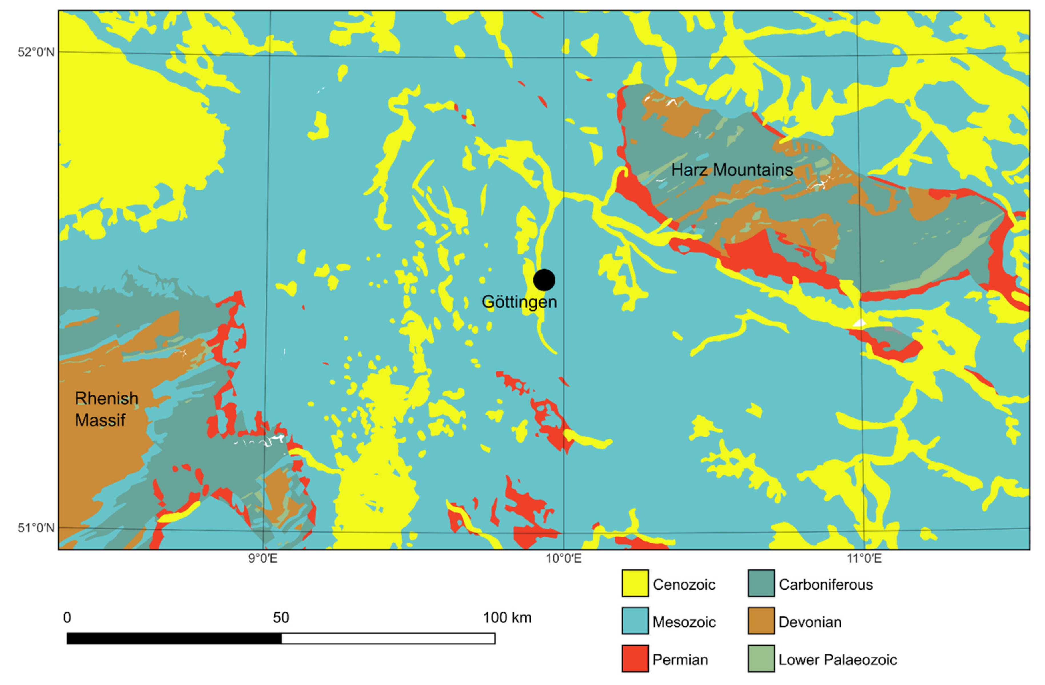
This section explains the rationale behind the use of the Harz Mountains as an analogue for the proposed EGS at Göttingen, gives an introduction to the geology of the region, and compares the analogue with the sub-surface geology we expect at Göttingen. In the absence of well data and with limited seismic data for the sub-Zechstein rocks, the rocks beneath the Permian Zechstein evaporites at Göttingen must be predicted. Devonian quartzitic sandstones and slates, and Carboniferous greywackes and slates (predominantly Culm flysch deposits) are exposed in the western Harz Mountains ~40 km to the NE and in the Rhenish Massif ~70 km to the SW (e.g., [16,17,18]), as shown in Figure 1. We have selected analogue sites in the Oberharz Anticline and the Culm Fold Zone, which belong to the parautochthonous domain of the Harz Mountains (e.g., [19]) because we consider these to be areas to have the best exposures of the sub-Zechstein rocks that are most likely to occur beneath Göttingen [20].

Figure 1.
Geological map showing the location of the Harz Mountains, where the exposed Devonian and Carboniferous rocks are used as an analogue for a proposed EGS at Göttingen. Additionally, shown is the Rhenish Massif, which also shows exposures of Devonian and Carboniferous rocks. Göttingen along strike of the Variscan belt between the Harz Mountains and the Rhenish Massif. The dominant lithologies are as follows. Lower Palaeozoic, Devonian and Carboniferous: metasedimentary sandstones, slates and carbonates. Permian: sandstones, marls and evaporites. Mesozoic: shales, sandstones and limestones. Cenozoic: unconsolidated siliciclastic sediments. Data source: GK1000© BGR, Hannover, 2013. Downloaded on 6 June 2022, from https://gdk.gdi-de.org/geonetwork/srv/api/records/5f77d681-b7e4-4dd0-8f15-7b93744450b0.
The Devonian and Carboniferous rocks of the region are part of the Variscan fold-thrust belt (e.g., [21]). Later deformation events in the region include Late Cretaceous and Cenozoic uplift and exhumation in the Harz Mountains (e.g., [22]) and Cenozoic rifting in the Göttingen area (the Leinetal Graben, e.g., [23]). The fractures visible in the exposures of the Harz Mountains include veins and joints [24,25], with cleavage being well-developed in the slates [26]. Thrusts that appear to have displacements of up to a few metres are exposed [27], but larger thrusts are not well-exposed. The north-eastern boundary the Harz Mountains is marked by the Harznordrand Fault, which was active during the Late Cretaceous and Tertiary (e.g., [28]). NW-SE striking Mesozoic normal and oblique-slip faults occur in the Harz Mountains, some of which contained economic Pb-Zn and Ba-F deposits [29].
Table 1 shows seven key parameters that control deformation of rocks and our predictions for the Variscan rocks that occur beneath Göttingen. Table 1 also includes comments on what can and cannot be learnt from the Harz Mountains. While the exposed analogues give useful information about lithologies, the conditions that existed during the Variscan Orogeny and about Variscan structures, they tend to give less information about subsequent conditions and deformation. For example, it is difficult to determine absolute ages of joints and to determine the tectonic conditions under which they formed. Differences between the rocks exposed in the Harz Mountains and those at a depth of more than 1.5 km beneath Göttingen include:

Table 1.
Key parameters that control rock deformation with predictions for the Variscan rocks beneath Göttingen and comments on what can and cannot be learnt from the exposed analogues in the Harz Mountains. For a list of parameters to be characterised in a geothermal reservoir, see [30].
- The Göttingen area has undergone post-Variscan rifting (the Leinetal Graben) and still has a cover sequence of Permian and Triassic sedimentary rocks about 1.5 km thick. The Harz Mountains, however, have undergone several kilometres of exhumation since the Late Cretaceous and have been fully exhumed (i.e., there is no cover sequence).
- The different overburden and tectonic regimes of the Harz Mountains and the Göttingen area mean that the post-Variscan (and present-day) stress magnitudes and orientations were different, potentially leading to different types and orientations of structures.
- For example, the graben formation at Göttingen is related to a set of N-S trending fault zones that consist of NNE-SSW striking en echelon segments, which may extend into the Variscan rocks. This set of faults is not observed in the Harz Mountains but may be comparable with a set of NW-SE striking Mesozoic normal and oblique-slip faults developed during the uplift of the Harz Mountains.
- Exhumation means that many of the post-Variscan structures observed in the Harz Mountains, especially the joints, may not occur at reservoir depths at Göttingen. We suggest, however, that the joints observed in the Harz Mountains give us strong indications of the patterns of induced fractures that would be created by stimulation of Variscan rocks beneath Göttingen. Both natural jointing and fracture development during artificial stimulation occurs as the rock responds to changes in stresses, fluid pressures and/or temperatures. Such observations as whether or not joints cross bedding planes or follow pre-existing veins therefore give indications about likely fracture behaviour during stimulation. As such, they are useful for predicting patterns of induced fractures and for use in DFN modelling.
- The cover sequence at Göttingen includes the Zechstein salt deposits, which may mean both that the pore fluids in the Variscan rocks may be saline and that those fluids could be overpressured.
3. Lessons Learnt about the Use of Analogues
We experienced the following problems and learnt the following lessons about the use of analogues for fractured geothermal reservoir rocks during the course of the MEET project.
3.1. Aims of Using an Exposed Analogue
A problem we had with the fieldwork in the Harz Mountains arose because it was undertaken for several different reasons. Although at the start of the project the aim was to develop a numerical model for fluid flow through the rocks [31], various other aims were introduced. These included: to create general and conceptional structural models for the Harz Mountains, to determine the histories of deformation and fluid flow, to make predictions about the sub-surface at Göttingen, and to provide data that could be used by colleagues to perform discrete fracture network (DFN) modelling of fluid flow in the sub-surface. While these different aims were not necessarily conflicting, they did lead to some confusion in deciding what types of structures were important to analyse, how best to analyse them, and what data were needed. For example, one of the methods used was to map traces of veins, joints and other fractures exposed on rock surfaces to provide inputs into DFN models. We realised, however, that these maps lacked vital information that would enable realistic DFN models for the sub-surface at Göttingen to be created (Section 3.3), although they did help us interpret the histories of deformation and fluid flow in the Harz Mountains.
A study of an exposed analogue needs to be set up carefully, including definition of the problems being addressed and the aims of the work. These aims then need to be translated into specific objectives, with careful consideration of the priorities of each, determination of the data needed, and establishment of the appropriate methods. It is also important to keep evaluating the work, to determine whether the approach is working, and to make changes as needed. General questions that may typically be asked about a potential exposed analogue include:
- Is the aim to make specific predictions about the rocks and structures in the sub-surface or is it to understand certain processes?
- What lithologies and lithological relationships occur?
- Can rock samples be collected that are suitable for determining geomechanical and petrophysical properties, and for geochemical analyses?
- What structures occur in the exposed analogues?
- What are the spatial and temporal relationships between those structures?
- What frequencies and patterns of open fractures occur in different lithologies, and what controls their development?
- Is there information about active fluid flow in the sub-surface, such as evidence of hydrothermal fluids in spring water?
An important lesson from our fieldwork in the Harz Mountains was not just that we needed to be clear at the start of the work what problems were being addressed, but that we needed to frequently review our progress in solving (and ability to solve) those problems and be prepared to adjust the approaches used.
3.2. Choice of Exposed Analogue
The Harz Mountains were an obvious choice for an analogue study because similar rocks are expected to occur in the sub-surface at Göttingen and are likely to have similar structures and deformation histories (Section 2 and Table 1). Furthermore, geographical proximity meant that long journeys and overnight accommodation were not needed for fieldwork. There are, however, two main problems with the Harz Mountains as an analogue study area. Firstly, the exposure quality is commonly poor, being restricted to steep road-cuts, abandoned quarries and natural exposures that are typically up to a few tens of metres long and a few metres high. Many of the best exposures are cliff faces formed by the dominant set of joints, which are steeply dipping and strike at a high angle to the Variscan folds, thrusts and cleavage. While these exposure surfaces are ideal for analysing the Variscan structures, they are poor for analysing the fracture networks, especially the joint systems, because it is difficult to analyse those structures in three dimensions. Secondly, while the Harz Mountains have undergone several kilometres of exhumation since the Late Cretaceous, the Göttingen area is in a Late Cretaceous and Cenozoic rift and has undergone far less exhumation (Table 1). Both areas, however, underwent post-Variscan, pre-Zechstein exhumation.
Lessons learnt about the choice of field areas from use of the Harz Mountains include the following:
- Göttingen lies between exposures of Devonian and Carboniferous metasedimentary rocks in the Harz Mountains and the Rhenish Massif (e.g., [21]). The field area and the geothermal reservoir rocks are therefore assumed to show similar lithologies (including lithological relationships, bed thicknesses, weathering, etc.), structural geometries, age relationships between those structures, tectonic histories, kinematics, mechanical properties and fluid flow histories. Although no exposed analogue is likely to show fractures (especially joints) that are a perfect match to the sub-surface, the analogue should show enough commonality to the reservoir to enable reasonable comparisons to be made about aspects of the geology.
- Exposure quality is important in controlling the data that can be obtained. The Harz Mountains are only approximately 50 km away from the proposed geothermal reservoir at Göttingen, and we aimed to correlate our results with those of partners in the MEET project who were carrying out fieldwork in the Rhenish Massif. An alternative, however, would have been to study more distance but better-exposed areas to make it easier to investigate fracture systems in three dimensions. For example, the Devonian and Carboniferous rocks in Cornwall, UK, are very well exposed in coastal cliffs and on wave-cut platforms (e.g., [32]). Even though the exposures on the coast of Cornwall are approximately 1000 km west of Göttingen, they may provide additional valuable information about the structures developed in Upper Palaeozoic sedimentary rocks in the Variscan Belt.
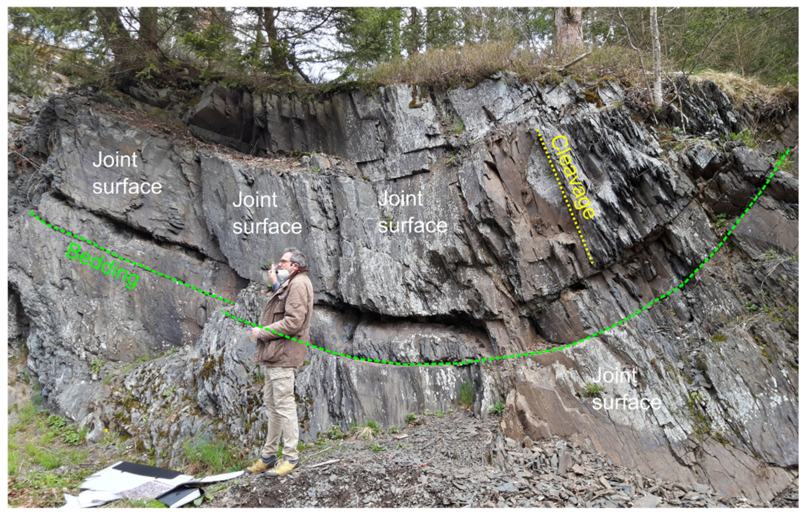
- There may be greater flexibility on the choice of analogue if the aim of the fieldwork is to understand processes rather than to obtain specific data about such information as the lithologies and types of structures that are likely to occur in a geothermal reservoir. For example, one question the fieldwork in the Harz Mountains addressed was whether slates can fracture, which would help us determine their reservoir properties and behaviour during stimulation. Veins and joints in the Upper Palaeozoic slates of the Harz Mountains (Figure 2) show that the slates have been prone to fracturing at different times in their history, so they have potential as reservoir rocks. The same observations could have been made on slates in other regions. Indeed, observations from a range of slates of different compositions, of different ages and subjected to different deformation histories, are likely to have improved knowledge about the reservoir properties of slates, thereby improving predictions for the sub-surface of Göttingen.
 Figure 2. Photograph of a syncline in Upper Palaeozoic slates at Schulenberg im Oberharz, Harz Mountains, Germany. Most of the exposure surface is defined by a set of steeply dipping joints that strike at a high angle to the fold.
3.3. What Exposed Analogues Can and Cannot Tell You
One of the main aims of the fieldwork in the Harz Mountains was to provide data about fracture networks and their relationships to folds to create a conceptual model that could be used in DFN modelling to predict fluid flow rates in the sub-surface at Göttingen. Such modelling requires such data as the in situ stresses as well as the apertures and connectivities of open fractures in the sub-surface (e.g., [33]). This information cannot be provided from rocks exposed at the surface. For example, joints commonly develop during exhumation (e.g., [34]), with the apertures, frequencies, sets and patterns of joints seen at the surface not necessarily being the same as those at reservoir depths. While the joints analysed in the Harz Mountains may give some indications about open fractures in the sub-surface at Göttingen, such as whether open fractures may be expected to occur in slates, they did not provide sufficient information about sub-surface fractures to enable meaningful DFN modelling to be undertaken.
Exposed analogues may provide information about such characteristics of sub-surface geology as lithologies, the geometries and kinematics of certain structures (e.g., folds, faults, veins), the histories of deformation and fluid flow, and aspects of mechanical behaviour (e.g., mechanical stratigraphy). Exposed analogues cannot, however, provide with much certainty information that is important for reservoir modelling, such as the presence and geometries of open fractures, fracture porosity, stresses, temperatures and fluid flow. Some certainty about conditions in the sub-surface will only be obtained when well data become available.
Fieldwork in the Harz Mountains, and our subsequent attempts to use the data to make predictions about the sub-surface geology at Göttingen taught us the importance of understanding what you can and cannot do with field data, and of conveying that information clearly to other people who may rely on those data. Both field geologists and reservoir modellers need to be aware of the limitations of field data, as to be aware of the uncertainty limitations of subsequent models. We found that field data are useful for developing initial models and for testing concepts (e.g., [35]), and we used data and observations from the field to make simple predictions about the effects of hydraulic stimulation in the potential geothermal reservoir rocks at Göttingen [15].
An important consideration in the comparison between an exposed analogue and a reservoir is that they have different histories, especially their burial and exhumation histories. Many of the structures that occur in the surface exposures in the Harz Mountains that are likely to be important in a geothermal reservoir at Göttingen probably post-date the Variscan Orogeny. These include the joints, many of which are likely to have been caused by exhumation (e.g., [36]). Such differences must be considered when comparing an exposed analogue with a reservoir.
3.4. Avoid Distracting Topics
Fieldwork in the Harz Mountains taught us the importance of focussing on the key aims of the study and of being careful to avoid spending too much time on by other interesting topics. Two aims of the project were: (1) discovering the ways and methods to use an exposed analogue for predicting the properties of enhanced geothermal systems, and (2) to use the exposures in the Harz Mountains to help us predict the characteristics and behaviour of the reservoir rocks beneath Göttingen. Fieldwork often leads to new, unexpected discoveries, and these should not be ignored. It is important, however, that such discoveries do not cause too much distraction from the aims of the field study. We were occasionally distracted by discussions about Variscan tectonics, which were not directly related to the aims of the fieldwork but did lead us towards new research projects. While an academic environment provides freedom to follow new ideas and research interests, it is still important to do the work expected by academic partners and by funding bodies. The need to stay focused on solving particular problems is more intense in industry, where managers and clients will expect particular outcomes from a study.
While the Harz Mountains were selected as an analogue because they show similar rocks and structures that are expected to occur beneath Göttingen, and these were compared with exposures in the Rhenish Massif, a more distant analogue site could have been selected, for example if the more distance analogue has better exposure. Key factors to consider in the choice of an analogue site include how well the lithologies and structures match the geothermal reservoir, and the quality of the exposure. As such, the ages of the rocks and of the deformation may be irrelevant.
3.5. Use of the Term “Fracture”
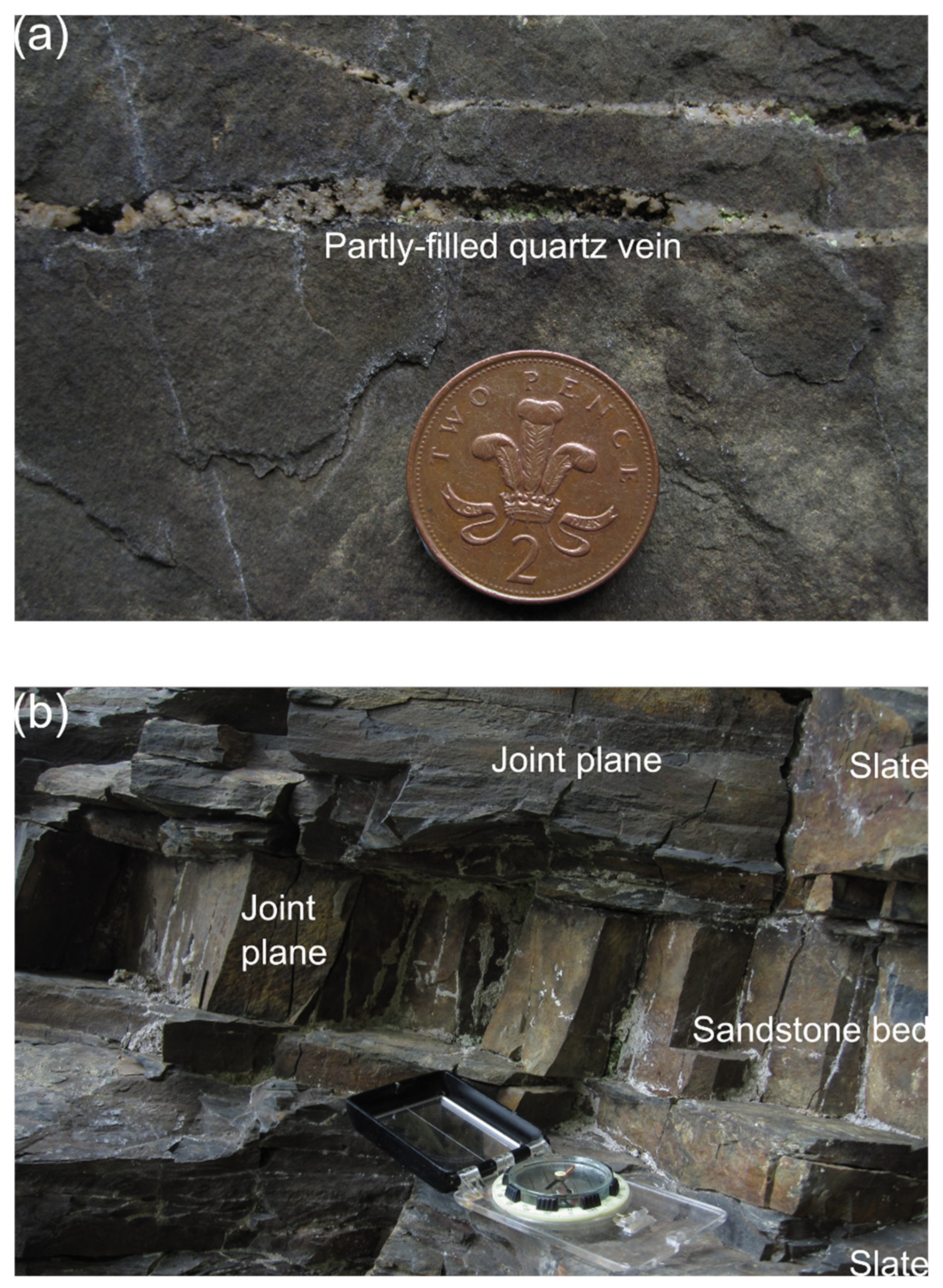
Our work in the Harz Mountains, and the subsequent attempts to use this work to make predictions about the sub-surface at Göttingen, showed the importance of specifying fracture types in the field. Reservoir modellers commonly use the general term “fracture”, and often do not distinguish between faults, veins, joints and other types of fracture. When field geologists also use “fracture”, they cannot properly understand the geometries, age relationships, tectonics, mechanics and fluid flow histories of the rocks and the fractures they contain [37,38]. Different fracture types have different origins, distributions and properties, hence different significance in predicting the engineering behaviour of a reservoir. For example, veins are fractures that are partly or completely sealed by minerals, while joints are not mineralised (Figure 3). Thus, veins will tend to have greater mechanical cohesion and are less likely to be conduits for present-day fluid flow, than joints. Veins also tend to be clustered, such as in fold hinges (e.g., [39]) and around faults (e.g., [40]), whilst joints tend to be more widely distributed in a rock mass (e.g., [41,42]). Such differences have significance for the properties of an EGS and on the ways the reservoir rocks respond to stimulation. Merging these different types of structures together as “fractures” during initial fieldwork in the Harz Mountains meant that important interpretations about the histories and significance of those structures could not be made.

Figure 3.
Photographs of different types of “fractures” in the Harz Mountains. (a) Partly filled quartz vein in a sandstone, which resulted from and gives information about palaeo fluid flow. The vein was either never completely cemented or has been subjected to weathering. The quartz will hinder present-day fluid flow through the vein. (b) Joints in sandstones and slates. Veins are (by definition) not mineralised, so are potential pathways for present-day fluid flow in the sub-surface.
Whilst geologists are generally well-aware of the significance of different types of fracture, engineers are more likely to think of a fracture simply as a surface across which the rock mass may lose cohesion or frictional resistance. To a reservoir engineer, a fracture may assume the role of a large void that facilitates fluid flow. A major problem occurs when these different groups start to communicate referring to everything as a “fracture”, mainly in the interest of finding a common language. In the MEET project, geologists investigating faults, veins, joints and other types of fracture would present their field data as measurements of the geometries and topologies of “fractures”. This can easily result in vein data being used to estimate fluid flow in DFNs (i.e., treated as “open” fractures, modelled by flow between parallel plates; see Section 3.7).
3.6. Palaeo Fluid Flow vs. Present-Day Fluid Flow
The fieldwork in the Harz Mountains taught us the importance of differentiating between studies of palaeo fluids and studies to make predictions about present-day fluid flow. This issue is related to use of the term “fracture” (Section 3.5), because the minerals within veins tend to give information about palaeo fluid flow (e.g., [43]), while knowledge about joints and other open fractures helps in predicting present-day fluid flow (Figure 3). For example, while the maps of fracture traces we created (Section 3.1) turned out to be of little use for DFN modelling, they did provide a basis for understanding the palaeo fluid flow through veins and the potential for present-day fluid flow through joints.
When the aims of the fieldwork are decided, it is important to study the appropriate fractures using appropriate methods. For example, a study of an ancient hydrothermal system should focus on veins and the minerals they contain, while a study to predict present-day fluid flow would tend to focus on joints and other open fractures.
3.7. Understanding the Needs of Other Disciplines
One of the original aims of the fieldwork in the Harz Mountains (and of other analogue areas used in the MEET project) was to obtain field data that could be used to create models to predict fluid flow in the sub-surface. A particular problem, however, was that the field geologists were not able to collect key data that the modellers, who were not geologists, needed to make realistic DFN models (Section 3.3). Such data included information about the apertures and connectivities of open fractures (e.g., joints) in the sub-surface. This led to mutual frustration. It is therefore important that field geologists are clear about what can and cannot be learnt from analogues, including what data can be collected. Another problem was that the field geologists would use terminology that the reservoir modellers did not understand and vice versa. An example of such miscommunication was the use of “fracture” by the reservoir modellers to mean a discontinuity along which fluids can flow in the present-day, while the geologists would use the term for any brittle discontinuity, regardless of the potential for fluid flow (Section 3.5). For example, if a field geologist reports an abundance of veins with apertures of 1–10 mm, this does not justify a modeller using open fractures with apertures of 1–10 mm in a DFN model.
Lessons from our experience of working with reservoir modellers to make predictions about the sub-surface at Göttingen include: (1) it is important to understand the data they need to develop their models; (2) modellers must be informed about what data can and cannot be provided from field data, and this should include information about the uncertainties in the field data; (3) a common understanding of the terms used by both geologists and non-geologists must be established.
4. Integration of Exposed Analogues in the Analysis of Geothermal Reservoirs
This section discusses how exposed analogue studies may be best integrated in the analysis of geothermal reservoirs.
4.1. Improved Understanding of the Contribution of Exposed Analogue Studies
The starting point of any scientific study is generally a question or problem that needs to be solved. The initial aims of the use of exposed analogues in the MEET project are described by [31]. Table 2 shows some of the questions that should be asked when setting up a study, either of a geothermal reservoir or an exposed analogue, along with elements that need to be considered in such studies. It also shows how exposed analogues may help answer those questions. Table 2 aims to show the importance of deciding what problems are to be addressed and determining the appropriate ways to solve those problems. We suggest four steps in determining how best to use an exposed analogue:
Table 2.
Examples of questions that should be asked when planning a study of a geothermal reservoir or of an exposed analogue. Additionally, shown are typical elements that need to be considered and comments about how exposed analogues can be used to study these elements.
- Decide whether the analogue is being used to understand a palaeo-hydrothermal system or to make predictions about present-day conditions in the sub-surface (Section 3.6).
- Determine what aspects of the analogue need to be characterised. Table 1 gives information about key parameters that control rock deformation, about which information is likely to be needed.
- Determine what data are needed and that can be obtained.
- Determine the appropriate analysis type or types. Analysis types commonly used to analyse geothermal reservoirs are shown in Table 2.
4.2. Modelling Techniques
As discussed in Section 3.3, exposed analogues cannot provide some information that reservoir modellers may need to create realistic DFN models. To make predictions about the sub-surface at Göttingen before well data are available, we therefore had to use modelling techniques. We used Mohr diagrams with realistic ranges of input parameters (mostly using data from the exposed analogues in the Harz Mountains) to make predictions about how the Devonian and Carboniferous rocks expected to occur beneath Göttingen will respond to stimulation [15]. Modelling techniques need to be used that are suited to answering the right questions at early stages of geothermal assessment, and that are feasible based on the data available at the pre-drilling stage.
4.3. Ranges and Variabilities of Parameters
The modelling approach we used to predict the response of rocks in the sub-surface at Göttingen used information obtained from the exposed analogues in the Harz Mountains (Section 4.2; [15]). This included information about the ranges and variabilities of such factors as rock mechanical properties and the geometries of structures (e.g., folds, veins and joints). Exposed analogues are therefore useful for providing realistic ranges of input parameters for modelling. In our experience, non-geologists tend to want a single value or answer for any given parameter. Exposed analogues are therefore particularly useful for informing people from other disciplines (such as reservoir modellers and drilling engineers) about such geological variabilities.
4.4. Knowledge Transfer
Another way exposed analogues can be used in the analysis of geothermal reservoirs is in improved communication and knowledge transfer between scientists from different disciplines (e.g., between geologists, reservoir modellers and drilling engineers). Discussions about exposed analogues, especially when undertaken in the field, can help geologists and non-geologists appreciate potential and actual links between surface and sub-surface geology, and between geology and other disciplines. Exposed analogues can be used to help answer a series of key questions, such as:
- What measurements are (and are not) needed for a specific model?
- Can geologists make such measurements?
- How much certainty do we have in those measurements?
- How can measurements be scaled for modelling purposes?
- Does the parameter-space in modelling adequately encompass the geological variability and uncertainty?
Expressing a model purely in terms of black-box equations will not usually help a geologist understand what the model does or how different parameters are used. Similarly, field data fed to modellers needs to be accompanied by information that captures potential factors that are important in its use (e.g., “open” vs. “closed” fractures, scale ranges over which data were collected).
5. Discussion of Other Uses of Analogue Exposures of Fractured Rock
Although we have used exposures in the Harz Mountains as analogues to make predictions about a proposed EGS, our experiences can give useful insights into the use of exposed analogues for other situations in which it may be important to predict fluid flow through fractures in the sub-surface. This includes use of analogues for studies on other types of geothermal systems (e.g., [44]), hydrogeology (e.g., [45]), nuclear waste storage (e.g., [46]), CO2 sequestration (e.g., [47]), mineral extraction (e.g., [48]), and petroleum resources (e.g., [49]). Any study using analogues has to be carefully planned and focussed so that specific questions about the sub-surface can be answered. The fieldwork must be of use to, and understandable by end-users from other disciplines.
As discussed in Section 3.3, it is important to understand what can and cannot be learnt from exposed analogues, and this will change based on the intended use of the analogue. For example, if the fieldwork is to collect information about veins that formed during particular time periods or tectonic events, then this information is likely to be directly applicable to understanding those vein systems that occur in the sub-surface (e.g., [50]). Note that certain minerals can be utilised for chemical stimulation (e.g., [51]). More care is needed, however, if the exposed analogue is used to map joint systems for direct use in DFN models of the sub-surface, especially if those joints formed during exhumation. For example, while the Devonian and Carboniferous rocks beneath Göttingen may have joints related to exhumation during and immediately after the Variscan Orogeny, they are less likely than the Harz Mountains to have joints related to Late Cretaceous and Cenozoic exhumation. Joints exposed at the surface may therefore not equate in a simple way to open fractures in the sub-surface.
6. Conclusions
While exposed analogues can provide critical information that can be used to make predictions about the sub-surface, including the behaviour of enhanced geothermal systems (EGS), care is needed in planning and executing fieldwork. We highlight key learning gained during our use of the Harz Mountains (Germany) as an analogue for an EGS at Göttingen, which will be applicable to studying analogues elsewhere:
- The aims of the analogue study need to be clearly established, with focus being placed on what questions will be addressed by the fieldwork (Table 2).
- A field area needs to be selected that is best suited to solving the problems being addressed. For example, an analogue should not necessarily be selected just because it is the nearest exposure of the rocks that are expected to occur in the EGS. While more distant field areas may show better-quality exposure, they must provide useful insights into the geothermal reservoir.
- It is important to understand, and to be clear with people from other disciplines, what information exposed analogues can and cannot give about the sub-surface. Exposed analogues may not provide the specific data required by, for example, dynamic modelling. Fieldwork can, however, provide critical insights into the likely behaviour of rocks in the sub-surface, such as whether natural or induced fractures will cut across bedding planes.
- Science is generally about solving problems, and exposed analogues for EGS must answer particular questions about the behaviour of reservoir rocks. It is therefore important to avoid letting interesting new topics cause too much distraction from the main aims of the fieldwork.
- It is unhelpful to use the term “fracture” as a field description, and the types of “fractures” must be defined during fieldwork. While veins give useful information about palaeo fluids, they are less likely to contribute to fluid flow in the sub-surface than are such open fractures as joints.
- A key decision about the exposed analogue is whether it is being used to obtain information about a palaeo hydrothermal system or to provide information about present-day fluid flow in the sub-surface.
- Because exposed analogues are often used to provide information to people from other disciplines, it is important to understand what those people need and to gain a common understanding between field geologists and the people who will be using the field data.
We make several suggestions for how studies of exposed analogue studies can be better integrated into the analysis of geothermal reservoirs:
- Improved understanding of the contributions exposed analogues can and cannot make to predicting the behaviour of geothermal reservoirs will help analogue studies be used more effectively.
- Modelling techniques need to be used that are appropriate to the data that are available.
- The fieldwork must establish the ranges and variabilities of parameters that will be used to understand an EGS. This information can then be used to predict the ranges of structures that are likely to be encountered in the sub-surface, and to help explain well data in the reservoir evaluation stage of EGS development.
- Exposed analogues can play a vital role in knowledge transfer between different disciplines, especially between field geologists, modellers and drilling engineers.
While we focus on the use of exposed analogues for EGS, much of this paper is applicable to other situations in which it is important to make predictions about fluid flow in the sub-surface. For example, understanding the behaviour of rocks, the structures within those rocks and their effects on fluid flow is vital to nuclear waste storage, CO2 sequestration, hydrogeology and the petroleum industry. In each of these applications, an appropriate exposed analogue should be studied in suitable ways to answer key questions that will enable predictions to be made about the sub-surface.
Author Contributions
Conceptualization, D.C.P.P., D.J.S. and B.L.; methodology, D.C.P.P., D.J.S. and B.L.; validation, D.C.P.P., D.J.S. and B.L.; resources, B.L.; data curation, B.L.; writing—original draft preparation, D.C.P.P.; writing—review and editing, D.J.S. and B.L.; supervision, B.L.; project administration, B.L.; funding acquisition, B.L. All authors have read and agreed to the published version of the manuscript.
Funding
This work has received funding from the European Union’s Horizon 2020 research and innovation programme (grant agreement No. 792037-MEET Project).
Institutional Review Board Statement
Not applicable.
Informed Consent Statement
Not applicable.
Data Availability Statement
No new data were created or analysed in this study. Data sharing is not applicable to this article.
Acknowledgments
Carl-Heinz Friedel is thanked for his helpful advice and discussions. We thank Paolo Pace and two anonymous reviewers for their helpful comments.
Conflicts of Interest
The authors declare no conflict of interest.
References
- Weydt, L.M.; Bär, K.; Colombero, C.; Comina, C.; Deb, P.; Lepillier, B.; Mandrone, G.; Milsch, H.; Rochelle, C.A.; Vagnon, F.; et al. Outcrop analogue study to determine reservoir properties of the Los Humeros and Acoculco geothermal fields, Mexico. Adv. Geosci. 2018, 45, 281–287. [Google Scholar] [CrossRef]
- Chappell, D.; Craw, D. Geological analogue for circumneutral pH mine tailings: Implications for long-term storage, Macraes Mine, Otago, New Zealand. Appl. Geochem. 2002, 17, 1105–1114. [Google Scholar] [CrossRef]
- Hodgetts, D. Laser scanning and digital outcrop geology in the petroleum industry: A review. Mar. Pet. Geol. 2013, 46, 335–354. [Google Scholar] [CrossRef]
- Klingbeil, R.; Kleineidam, S.; Asprion, U.; Aigner, T.; Teutsch, G. Relating lithofacies to hydrofacies: Outcrop-based hydrogeological characterisation of Quaternary gravel deposits. Sediment. Geol. 1999, 129, 299–310. [Google Scholar] [CrossRef]
- Krauskopf, K.B. Geology of high-level nuclear waste disposal. Annu. Rev. Earth Planet. Sci. 1988, 16, 173–200. [Google Scholar] [CrossRef]
- Bickle, M.; Kampman, N. Lessons in carbon storage from geological analogues. Geology 2013, 41, 525–526. [Google Scholar] [CrossRef]
- Christie-Blick, N.; Driscoll, N.W. Sequence stratigraphy. Annu. Rev. Earth Planet. Sci. 1995, 23, 451–478. [Google Scholar] [CrossRef]
- Guntau, M. Concepts of Natural Law and Time in the History of Geology. Earth Sci. Hist. 1989, 8, 106–110. [Google Scholar]
- Middleton, G.V. Johannes Walther’s Law of the Correlation of Facies. Geol. Soc. Am. Bull. 1973, 84, 979–988. [Google Scholar] [CrossRef]
- Alexander, J. A discussion on the use of analogues for reservoir geology. In Advances in Reservoir Geology; Ashton, M., Ed.; Geological Society of London: London, UK, 1993; Volume 69, pp. 175–194. [Google Scholar]
- Morley, C.K. Developments in the structural geology of rifts over the last decade and their impact on hydrocarbon exploration. In Hydrocarbon Habitat in Rift Basins; Lambiase, J.J., Ed.; Geological Society of London: London, UK, 1995; Volume 80, pp. 1–32. [Google Scholar]
- Gillis, K.; Roberts, M. Cracking at the magma–hydrothermal transition: Evidence from the Troodos Ophiolite, Cyprus. Earth Planet. Sci. Lett. 1999, 169, 227–244. [Google Scholar] [CrossRef]
- Sanderson, D.J. Field-based structural studies as analogues to sub-surface reservoirs. In Value of Outcrop Studies in Reducing Subsurface Uncertainty and Risk in Hydrocarbon Exploration and Production; Bowman, M., Smyth, H.R., Good, T.R., Passey, S.R., Hirst, J.P.P., Jordan, C.J., Eds.; Geological Society of London: London, UK, 2016; Volume 436, pp. 207–217. [Google Scholar]
- Engelder, T.; Gross, M. Pancake joints in Utica gas shale: Mechanisms for lifting overburden during exhumation. J. Struct. Geol. 2018, 117, 241–250. [Google Scholar] [CrossRef]
- Peacock, D.; Sanderson, D.J.; Leiss, B. Use of Mohr Diagrams to Predict Fracturing in a Potential Geothermal Reservoir. Geosciences 2021, 11, 501. [Google Scholar] [CrossRef]
- Fielitz, W. Variscan transpressive inversion in the northwestern central rhenohercynian belt of western Germany. J. Struct. Geol. 1992, 14, 547–563. [Google Scholar] [CrossRef]
- Franke, W. The mid-European segment of the Variscides: Tectonostratigraphic units, terrane boundaries and plate tectonic evolution. In Orogenic Processes: Quantification and Modelling in the Variscan Belt; Franke, W., Haak, V., Oncken, O., Tanner, D., Eds.; Geological Society of London: London, UK, 2000; Volume 179, pp. 35–61. [Google Scholar]
- Franke, W. Rheno-Hercynian belt of central Europe: Review of recent findings and comparisons with south-west England. Geosci. South West Engl. 2007, 11, 263–272. [Google Scholar]
- Friedel, C.-H.; Huckriede, H.; Leiss, B.; Zweig, M. Large-scale Variscan shearing at the southeastern margin of the eastern Rhenohercynian belt: A reinterpretation of chaotic rock fabrics in the Harz Mountains, Germany. Int. J. Earth Sci. 2019, 108, 2295–2323. [Google Scholar] [CrossRef]
- Leiss, B.; Friedel, C.H.; Heinrichs, T.; Tanner, D.C.; Vollbrecht, A.; Wagner, B.; Wemmer, K. Das Rhenohercynikum als geothermischer Erkundungshorizont im Raum Göttingen. In Harzgeologie 2016. 5. Workshop Harzgeologie—Kurzfassungen und Exkursionsführer; Friedel, C.H., Leiss, B., Eds.; Universitätsverlag Göttingen: Göttingen, Germany, 2016; p. 31. [Google Scholar] [CrossRef]
- Brink, H.-J. The Variscan Deformation Front (VDF) in Northwest Germany and Its Relation to a Network of Geological Features Including the Ore-Rich Harz Mountains and the European Alpine Belt. Int. J. Geosci. 2021, 12, 447–486. [Google Scholar] [CrossRef]
- Von Eynatten, H.; Dunkl, I.; Brix, M.; Hoffmann, V.-E.; Raab, M.; Thomson, S.N.; Kohn, B. Late Cretaceous exhumation and uplift of the Harz Mountains, Germany: A multi-method thermochronological approach. Int. J. Earth Sci. 2019, 108, 2097–2111. [Google Scholar] [CrossRef]
- Tanner, D.; Leiss, B.; Vollbrecht, A.; Kallweit, W.; Meier, S.; Oelrich, A.; Reyer, D. The Role of Strike-Slip Tectonics in the Leinetal Graben, Lower Saxony. Geotecton. Res. 2008, 95, 166–168. [Google Scholar] [CrossRef]
- Friedel, C.H.; Hoffmann, C. Stopp 4: Schichtgebundene Deformationsstrukturen in der Kulmgrauwacke des Oberharzes (Bundesstraße 242). In Harzgeologie 2016. 5. Workshop Harzgeologie Kurzfassungen und Exkursionsführer; Friedel, C.H., Leiss, B., Eds.; Universitätsverlag Göttingen: Göttingen, Germany, 2016; pp. 85–90. [Google Scholar]
- Lippold, T. Vein Formation in the Variscan Slates and Greywackes of the Upper Harz Mountains—An Attempt of a Macro- and Microscopic Characterization and Interpretation. Master’s Thesis, Georg-August-Universität Göttingen, Göttingen, Germany, 2020. [Google Scholar]
- Zeuner, M. Conceptual 3D-Structure Model of the Variscan “Culm Fold Zone” in the Vicinity of the Oktertal dam (Harz Mountains, Germany) in Terms of Geothermal Reservoir Development. Master’s Thesis, Georg-August-Universität Göttingen, Göttingen, Germany, 2018. [Google Scholar]
- Wagner, B.; Leiss, B.; Tanner, D.C. Stopp 2: Gefalteter unterkarbonischer Kieselschiefer am Bielstein nördlich Lautenthal (Innerstetal). In Harzgeologie 2016. 5. Workshop Harzgeologie Kurzfassungen und Exkursionsführer; Friedel, C.H., Leiss, B., Eds.; Universitätsverlag Göttingen: Göttingen, Germany, 2016; pp. 69–78. [Google Scholar]
- Franzke, H.J.; Hauschke, N.; Hellmund, M. Spätpleistozäne bis holozäne Tektonik an der Harznordrand-Störung bei Benzingerode (Sachsen-Anhalt). In Harzgeologie 2016. 5. Workshop Harzgeologie Kurzfassungen und Exkursionsführer; Friedel, C.H., Leiss, B., Eds.; Universitätsverlag Göttingen: Göttingen, Germany, 2016; pp. 13–17. [Google Scholar]
- De Graaf, S.; Lüders, V.; Banks, D.A.; Sośnicka, M.; Reijmer, J.J.G.; Kaden, H.; Vonhof, H.B. Fluid evolution and ore deposition in the Harz Mountains revisited: Isotope and crush-leach analyses of fluid inclusions. Miner. Depos. 2020, 55, 47–62. [Google Scholar] [CrossRef]
- Wagner, B.; Günther, S.; Ford, K.; Sosa, G.M.; Leiss, B. The “Hexagon concept”: A fundamental approach for the geoscientific spatial data compilation and analysis at European scale to define the geothermal potential of Variscan and pre-Variscan low- to high-grade metamorphic and intrusive rocks. In Proceedings of the World Geothermal Congress 2021, Reykjavik, Iceland, 24–27 October 2021; pp. 1–10. [Google Scholar]
- Trullenque, G.; Bär, K.; Turan, A.; Schulz, K.; Leiss, B.; Ford, F.; Reinecker, J.; Vanbrabant, Y. Evaluation of Outcrop Analogues of the Four Variscan Reservoir Types, MEET Report, Deliverable D5.4. 2020; 48p. Available online: https://www.meet-h2020.com/project-results/deliverables/ (accessed on 29 June 2022).
- Lloyd, G.E.; Chinnery, N. The Bude Formation, SW England—A three-dimensional, intra-formational Variscan imbricate stack? J. Struct. Geol. 2002, 24, 1259–1280. [Google Scholar] [CrossRef]
- Lei, Q.; Latham, J.P.; Tsang, C.F. The use of discrete fracture networks for modelling coupled geomechanical and hydrological behaviour of fractured rocks. Comput. Geotech. 2017, 85, 151–176. [Google Scholar] [CrossRef]
- Loope, D.B.; Burberry, C.M. Sheeting joints and polygonal patterns in the Navajo Sandstone, southern Utah: Controlled by rock fabric, tectonic joints, buckling, and gullying. Geosphere 2018, 14, 1818–1836. [Google Scholar] [CrossRef]
- Romanov, D.; Leiss, B. Analysis of Enhanced Geothermal System Development Scenarios for District Heating and Cooling of the Göttingen University Campus. Geosciences 2021, 11, 349. [Google Scholar] [CrossRef]
- Nadan, B.J.; Engelder, T. Microcracks in New England granitoids: A record of thermoelastic relaxation during exhumation of intracontinental crust. Geol. Soc. Am. Bull. 2009, 121, 80–99. [Google Scholar] [CrossRef]
- Manda, A.K.; Horsman, E. Fracturesis Jointitis: Causes, symptoms, and treatment in groundwater communities. Groundwater 2015, 53, 836–840. [Google Scholar] [CrossRef]
- Peacock, D.C.P.; Sanderson, D.J. Structural analyses and characterising fracture networks: Seven pillars of wisdom. Earth Sci. Rev. 2018, 184, 13–28. [Google Scholar] [CrossRef]
- Narahara, D.K.; Wiltschko, D.V. Deformation in the hinge region of a chevron fold, Valley and Ridge Province, central Pennsylvania. J. Struct. Geol. 1986, 8, 157–168. [Google Scholar] [CrossRef]
- Kenworthy, S.; Hagemann, S.G. Fault and vein relationships in a reverse fault system at the Centenary orebody (Darlot gold deposit), Western Australia: Implications for gold mineralisation. J. Struct. Geol. 2007, 29, 712–735. [Google Scholar] [CrossRef]
- Gillespie, P.; Walsh, J.; Watterson, J.; Bonson, C.; Manzocchi, T. Scaling relationships of joint and vein arrays from The Burren, Co. Clare, Ireland. J. Struct. Geol. 2001, 23, 183–201. [Google Scholar] [CrossRef]
- Peacock, D.C.P. Differences between veins and joints using the example of the Mesozoic limestones of Somerset. In The Initiation, Propagation, and Arrest of Joints and Other Fractures; Special Publication; Cosgrove, J.W., Engelder, T., Eds.; Geological Society of London: London, UK, 2004; Volume 231, pp. 209–221. [Google Scholar]
- Middleton, D.; Parnell, J.; Carey, P.; Xu, G. Reconstruction of fluid migration history in Northwest Ireland using fluid inclusion studies. J. Geochem. Explor. 2000, 69–70, 673–677. [Google Scholar] [CrossRef]
- Bauer, J.F.; Krumbholz, M.; Meier, S.; Tanner, D.C. Predictability of properties of a fractured geothermal reservoir: The opportunities and limitations of an outcrop analogue study. Geotherm. Energy 2017, 5, 24. [Google Scholar] [CrossRef] [Green Version]
- Al-Ajmi, H.; Hinderer, M.; Keller, M.; Rausch, R.; Blum, P.; Bohnsack, D. The role of outcrop analogue studies for the characterization of aquifer properties. Int. J. Water Resour. Arid. Environ. 2011, 1, 48–54. [Google Scholar]
- Follin, S.; Hartley, L.; Rhén, I.; Jackson, P.; Joyce, S.; Roberts, D.; Swift, B. A methodology to constrain the parameters of a hydrogeological discrete fracture network model for sparsely fractured crystalline rock, exemplified by data from the proposed high-level nuclear waste repository site at Forsmark, Sweden. Hydrogeol. J. 2013, 22, 313–331. [Google Scholar] [CrossRef]
- Ogata, K.; Senger, K.; Braathen, A.; Tveranger, J.; Olaussen, S. The importance of natural fractures in a tight reservoir for potential CO2 storage: Case study of the upper Triassic to middle Jurassic Kapp Toscana Group (Spitsbergen, Arctic Norway). In Advances in the Study of Fractured Reservoirs; Spence, G.H., Redfern, J., Aguilera, R., Bevan, T.G., Cosgrove, J.W., Couples, G.D., Daniel, J.M., Eds.; Geological Society of London: London, UK, 2012; Volume 374, pp. 395–415. [Google Scholar]
- Sanderson, D.J.; Roberts, S.; Gumiel, P.; Greenfield, C. Quantitative Analysis of Tin- and Tungsten-Bearing Sheeted Vein Systems. Econ. Geol. 2008, 103, 1043–1056. [Google Scholar] [CrossRef]
- Iñigo, J.F.; Laubach, S.E.; Hooker, J.N. Fracture abundance and patterns in the Subandean fold and thrust belt, Devonian Huamampampa Formation petroleum reservoirs and outcrops, Argentina and Bolivia. Mar. Pet. Geol. 2012, 35, 201–218. [Google Scholar] [CrossRef]
- Garofalo, P.; Heinrich, C.; Matthäi, S.K. Three-dimensional geometry, ore distribution and time-integrated mass transfer through the quartz-tourmaline-gold vein network of the Sigma deposit (Abitibi belt, Canada). Geofluids 2002, 2, 217–232. [Google Scholar] [CrossRef]
- Na, J.; Xu, T.; Jiang, Z.; Bao, X.; Yongdong, W.; Feng, B. A study on the interaction of mud acid with rock for chemical stimulation in an enhanced geothermal system. Environ. Earth Sci. 2016, 75, 1025. [Google Scholar] [CrossRef]
Publisher’s Note: MDPI stays neutral with regard to jurisdictional claims in published maps and institutional affiliations. |
© 2022 by the authors. Licensee MDPI, Basel, Switzerland. This article is an open access article distributed under the terms and conditions of the Creative Commons Attribution (CC BY) license (https://creativecommons.org/licenses/by/4.0/).