
Topographical Impact on Snow Cover Distribution in the Trans-Himalayan Region of Ladakh, India


Abstract
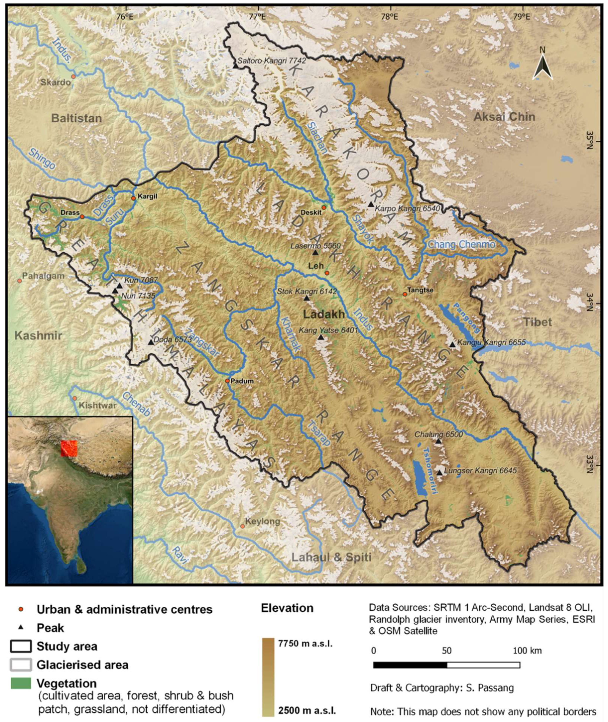
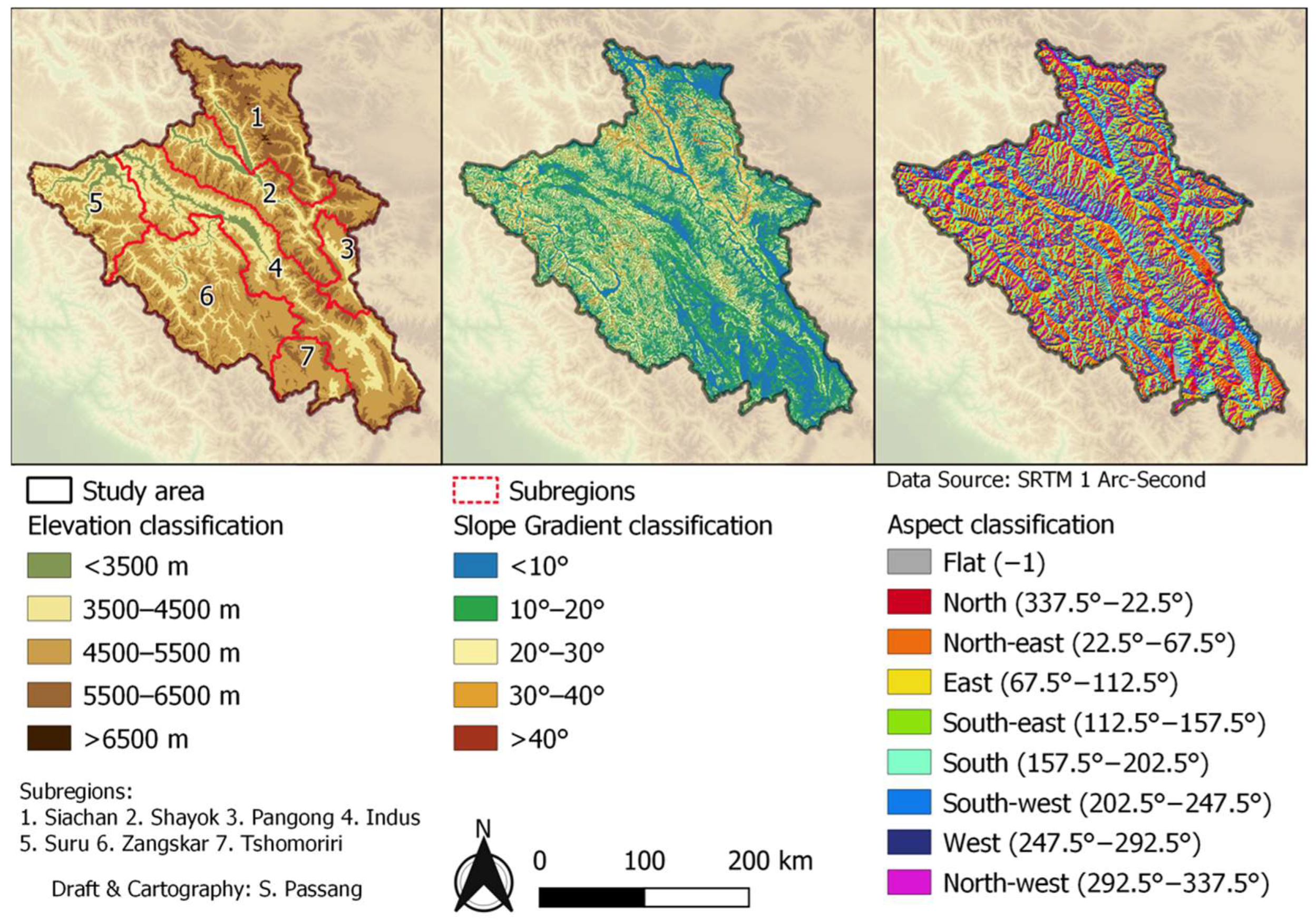
:1. Introduction
2. Materials and Methods
2.1. Materials
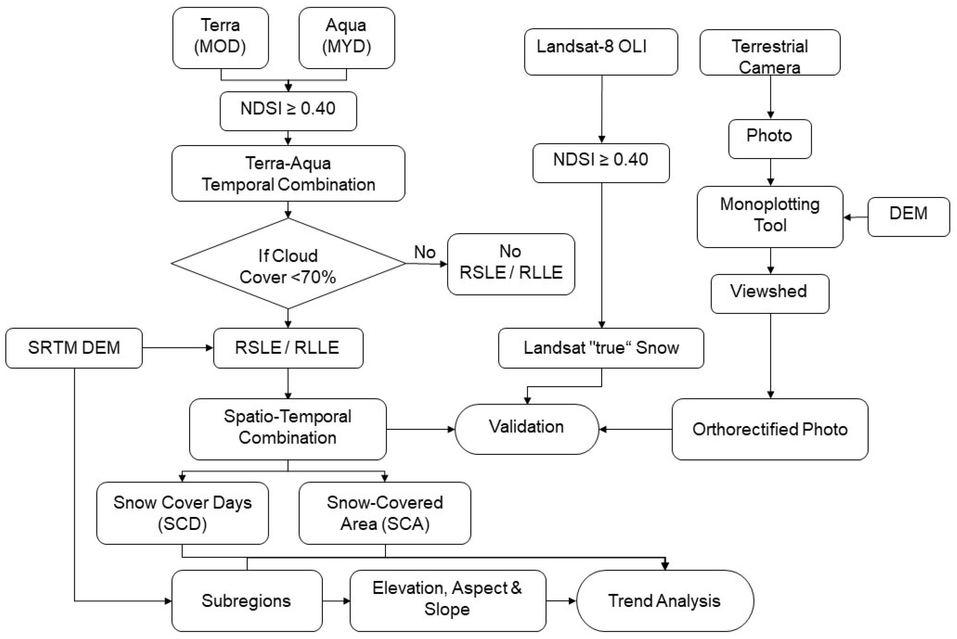
2.2. Methods
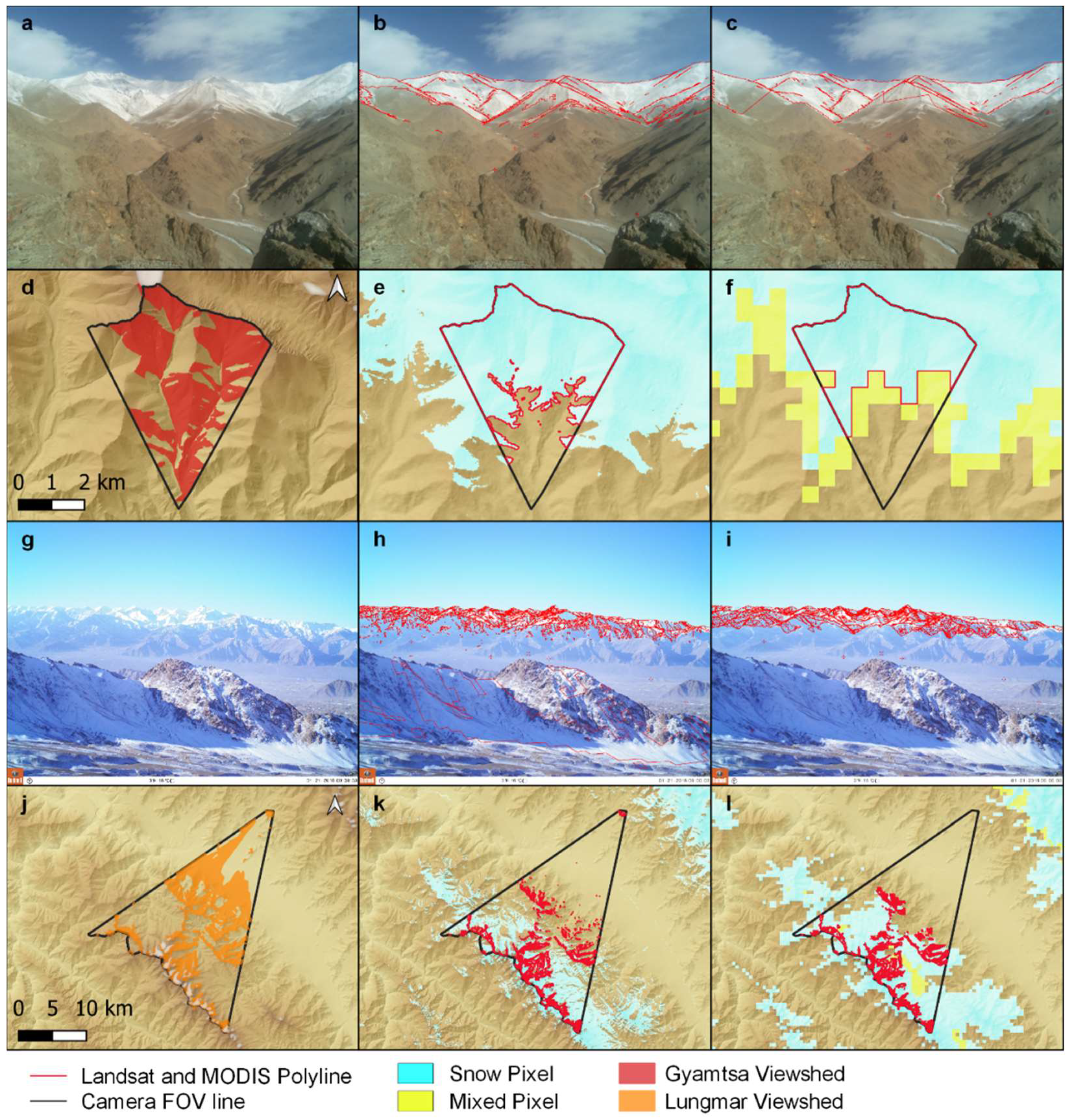
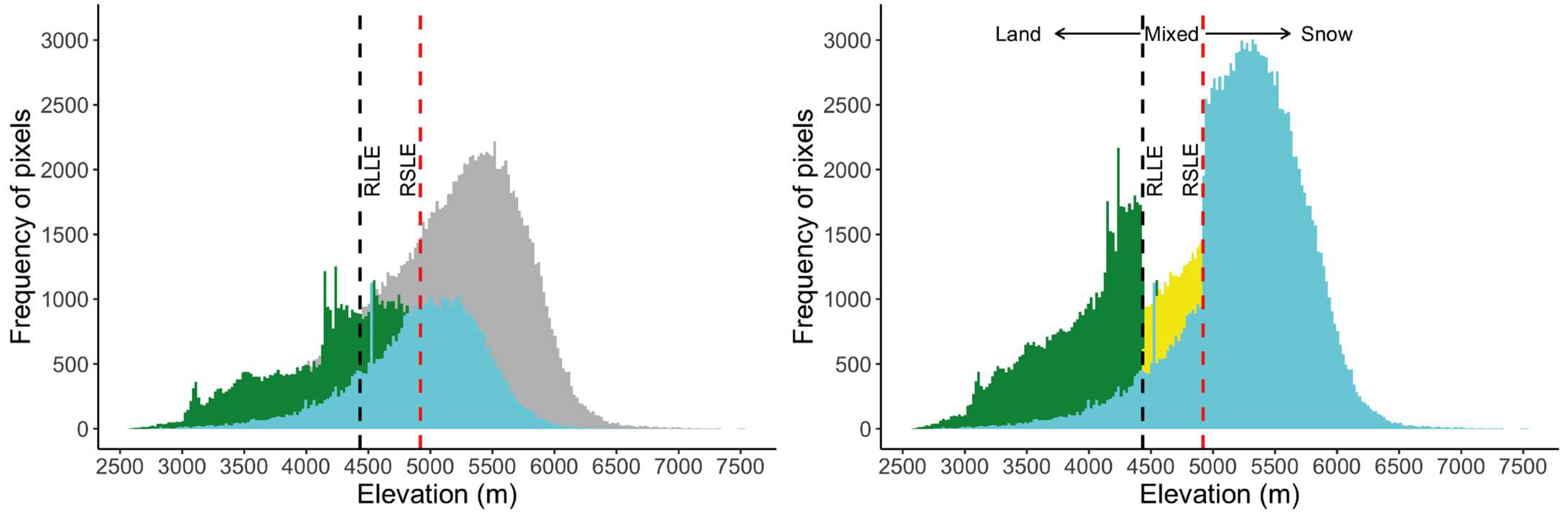
2.2.1. NDSI Threshold Value Calibration
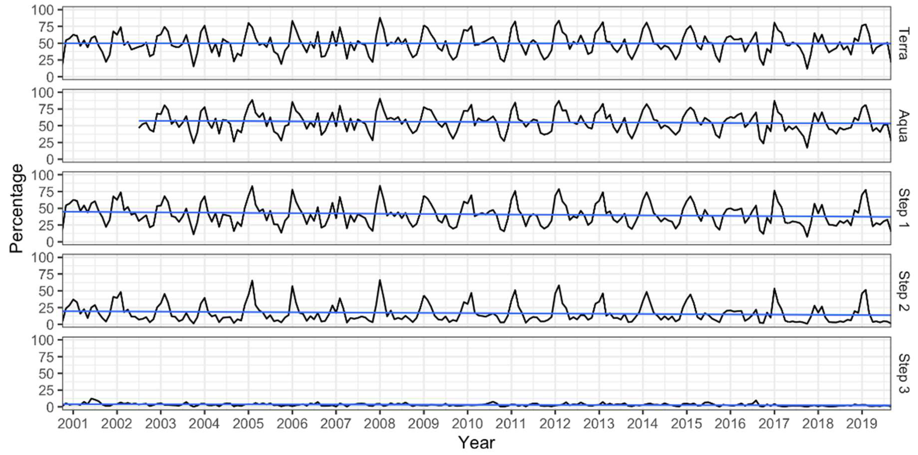
2.2.2. Methods Applied for MODIS Cloud Removal
2.2.3. Snow Trend and Correlation Analysis
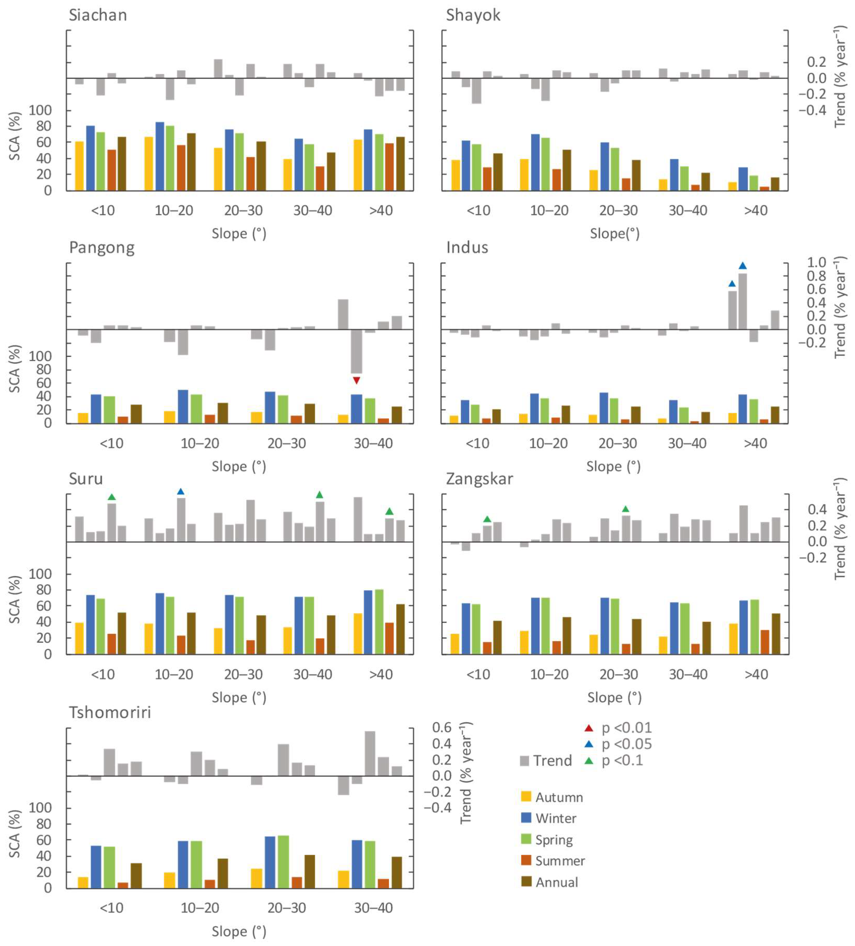
3. Results
4. Discussion
5. Conclusions
Author Contributions
Funding
Institutional Review Board Statement
Informed Consent Statement
Data Availability Statement
Acknowledgments
Conflicts of Interest
Appendix A

| Jan | Feb | Mar | Apr | May | Jun | Jul | Aug | Sep | Oct | Nov | Dec | Aut. | Win. | Spr. | Sum. | Ann. | |
|---|---|---|---|---|---|---|---|---|---|---|---|---|---|---|---|---|---|
| Z-Value | 0.28 | −0.70 | −0.91 | −0.56 | −1.26 | −2.10 | −2.35 | −1.33 | −0.21 | −0.77 | −0.28 | 0.28 | −0.56 | 0.42 | −1.19 | −2.10 | −1.12 |
| p-Value | 0.78 | 0.48 | 0.36 | 0.58 | 0.21 | 0.04 | 0.02 | 0.18 | 0.83 | 0.44 | 0.78 | 0.78 | 0.58 | 0.67 | 0.23 | 0.04 | 0.26 |
| Sen’s S. | 1.56 | −2.59 | −3.35 | −1.10 | −2.16 | −5.20 | −5.56 | −1.29 | −0.73 | −2.67 | −2.39 | 2.08 | −2.08 | 0.56 | −2.97 | −3.53 | −1.75 |
| Lin. S. | −0.85 | −1.42 | −2.38 | −1.24 | −2.55 | −5.13 | −5.29 | −1.40 | −1.32 | −2.8 | −2.32 | 2.95 | −1.92 | 0.23 | −2.06 | −3.94 | −1.98 |
| Mean | 4832 | 4813 | 4958 | 5097 | 5247 | 5390 | 5526 | 5560 | 5478 | 5378 | 5212 | 5011 | 5353 | 4885 | 5100 | 5492 | 5208 |
| SD | 84.7 | 75.3 | 63.7 | 53.1 | 54.1 | 59.1 | 56.3 | 30.3 | 58.3 | 77.4 | 122.2 | 94.4 | 62.3 | 50.4 | 49.3 | 43.9 | 32.5 |
| Trend | ⬆ | ⬇ | ⬇ | ⬇ | ⬇ | ⬇ | ⬇ | ⬇ | ⬇ | ⬇ | ⬇ | ⬆ | ⬇ | ⬆ | ⬇ | ⬇ | ⬇ |
| Jan | Feb | Mar | Apr | May | Jun | Jul | Aug | Sep | Oct | Nov | Dec | Aut. | Win. | Spr. | Sum. | Ann. | |
|---|---|---|---|---|---|---|---|---|---|---|---|---|---|---|---|---|---|
| Indus | |||||||||||||||||
| Z-Value | −1.05 | 1.19 | 0.21 | −0.83 | 0.00 | 1.86 | 1.61 | 0.63 | 0.00 | −0.07 | −0.42 | −0.21 | −0.14 | −0.28 | −1.07 | 0.63 | −0.07 |
| p-Value | 0.29 | 0.23 | 0.83 | 0.41 | 1.00 | 0.06 | 0.11 | 0.53 | 1.00 | 0.94 | 0.67 | 0.83 | 0.89 | 0.78 | 0.28 | 0.53 | 0.94 |
| Sen’s S. | −0.53 | 0.61 | 0.06 | −0.16 | 0.04 | 0.10 | 0.7 | 0.05 | −0.04 | −0.07 | −0.14 | −0.15 | −0.07 | −0.12 | −0.07 | 0.08 | −0.02 |
| Lin. S. | −0.19 | 0.31 | 0.10 | −0.19 | −0.14 | 0.08 | 0.23 | 0.06 | −0.03 | 0.08 | −0.04 | −0.28 | −0.01 | −0.05 | −0.07 | 0.12 | 0.00 |
| Mean | 44.78 | 51.83 | 46.42 | 35.03 | 23.08 | 13.61 | 5.06 | 3.76 | 7.79 | 12.62 | 17.90 | 26.71 | 12.86 | 41.11 | 34.84 | 7.47 | 24.05 |
| SD | 12.51 | 11.87 | 10.72 | 7.66 | 5.49 | 4.62 | 3.26 | 1.43 | 5.38 | 7.73 | 8.83 | 10.83 | 6.16 | 7.51 | 7.04 | 2.61 | 4.31 |
| Trend | ⬇ | ⬆ | ⬆ | ⬇ | ⬆ | ⬆ | ⬆ | ⬆ | ⬇ | ⬇ | ⬇ | ⬇ | ⬇ | ⬇ | ⬇ | ⬆ | ⬇ |
| Pangong | |||||||||||||||||
| Z-Value | −0.35 | 0.70 | 0.28 | −0.84 | −0.28 | −0.50 | 1.82 | 0.53 | 0.53 | −0.21 | −0.42 | −1.05 | −0.42 | −0.91 | −0.26 | 0.28 | 0.00 |
| p-Value | 0.73 | 0.48 | 0.78 | 0.40 | 0.78 | 0.62 | 0.07 | 0.60 | 0.60 | 0.83 | 0.67 | 0.29 | 0.67 | 0.36 | 0.80 | 0.78 | 1.00 |
| Sen’s S. | −0.16 | 0.38 | 0.19 | −0.26 | −0.12 | −0.04 | 0.21 | 0.04 | 0.16 | −0.07 | −0.26 | −0.63 | −0.18 | −0.23 | −0.01 | 0.04 | 0.02 |
| Lin. S. | −0.14 | −0.05 | 0.09 | −0.21 | −0.20 | 0.08 | 0.28 | 0.10 | 0.07 | 0.05 | −0.08 | −0.71 | −0.03 | −0.30 | −0.11 | 0.15 | −0.06 |
| Mean | 49.21 | 57.71 | 53.62 | 42.64 | 30.03 | 18.73 | 8.07 | 6.88 | 10.91 | 16.46 | 21.89 | 32.01 | 16.51 | 46.31 | 42.10 | 11.23 | 29.01 |
| SD | 14.81 | 11.97 | 12.62 | 8.03 | 6.72 | 6.44 | 3.90 | 2.22 | 6.02 | 10.44 | 10.65 | 12.92 | 7.24 | 8.94 | 8.15 | 3.44 | 4.82 |
| Trend | ⬇ | ⬆ | ⬆ | ⬇ | ⬇ | ⬇ | ⬆ | ⬆ | ⬆ | ⬇ | ⬇ | ⬇ | ⬇ | ⬇ | ⬇ | ⬆ | ⬆ |
| Shayok | |||||||||||||||||
| Z-Value | −0.91 | 0.56 | −0.63 | −0.56 | −0.56 | 0.90 | 1.40 | 0.21 | 0.49 | 0.70 | 0.14 | −0.42 | 0.07 | −0.35 | −1.05 | 0.35 | 0.14 |
| p-Value | 0.36 | 0.58 | 0.53 | 0.58 | 0.58 | 0.37 | 0.16 | 0.83 | 0.62 | 0.48 | 0.89 | 0.67 | 0.94 | 0.73 | 0.29 | 0.73 | 0.89 |
| Sen’s S. | −0.33 | 0.17 | −0.21 | −0.25 | −0.19 | 0.07 | 0.27 | 0.01 | 0.11 | 0.45 | 0.18 | −0.32 | 0.06 | −0.10 | −0.16 | 0.09 | 0.04 |
| Lin. S. | 0.03 | 0.04 | −0.20 | −0.24 | −0.22 | 0.04 | 0.42 | 0.09 | 0.02 | 0.34 | 0.08 | −0.29 | 0.13 | −0.08 | −0.22 | 0.18 | 0.01 |
| Mean | 65.32 | 67.70 | 64.63 | 58.53 | 48.38 | 34.56 | 18.16 | 13.46 | 22.10 | 32.42 | 41.42 | 52.44 | 32.12 | 61.82 | 57.18 | 22.06 | 43.26 |
| SD | 8.39 | 7.04 | 5.85 | 5.67 | 5.88 | 7.48 | 6.34 | 2.22 | 6.36 | 9.39 | 10.89 | 12.59 | 6.54 | 5.94 | 4.98 | 4.82 | 4.07 |
| Trend | ⬇ | ⬆ | ⬇ | ⬇ | ⬇ | ⬆ | ⬆ | ⬆ | ⬆ | ⬆ | ⬆ | ⬇ | ⬆ | ⬇ | ⬇ | ⬆ | ⬆ |
| Siachan | |||||||||||||||||
| Z-Value | 0.07 | −0.63 | −0.91 | −0.56 | −0.14 | −0.07 | 1.26 | 0.49 | 0.21 | 0.14 | 0.28 | −0.07 | 0.35 | 0.07 | −1.05 | 0.63 | −0.21 |
| p-Value | 0.94 | 0.53 | 0.36 | 0.58 | 0.89 | 0.94 | 0.21 | 0.62 | 0.83 | 0.89 | 0.78 | 0.94 | 0.73 | 0.94 | 0.29 | 0.53 | 0.83 |
| Sen’s S. | 0.05 | −0.10 | −0.26 | −0.37 | −0.10 | −0.03 | 0.31 | 0.07 | 0.05 | 0.09 | 0.08 | −0.04 | 0.04 | 0.01 | −0.24 | 0.13 | −0.04 |
| Lin. S. | 0.10 | −0.09 | −0.24 | −0.38 | −0.29 | −0.19 | 0.27 | 0.05 | 0.00 | 0.10 | 0.10 | −0.05 | 0.07 | −0.01 | −0.31 | 0.04 | −0.05 |
| Mean | 81.55 | 81.76 | 78.63 | 74.62 | 67.48 | 57.45 | 46.35 | 41.85 | 51.53 | 58.63 | 64.34 | 73.57 | 58.25 | 78.96 | 73.58 | 48.55 | 64.81 |
| SD | 4.91 | 4.43 | 5.23 | 7.10 | 6.89 | 5.80 | 5.17 | 2.33 | 4.91 | 7.26 | 8.00 | 8.29 | 4.59 | 3.98 | 5.53 | 3.81 | 3.20 |
| Trend | ⬆ | ⬇ | ⬇ | ⬇ | ⬇ | ⬇ | ⬆ | ⬆ | ⬆ | ⬆ | ⬆ | ⬇ | ⬆ | ⬆ | ⬇ | ⬆ | ⬇ |
| Suru | |||||||||||||||||
| Z-Value | 0.42 | −0.14 | −0.49 | 0.77 | 0.49 | 1.61 | 2.24 | 2.03 | 0.56 | 0.28 | 0.84 | 0.28 | 0.49 | 0.35 | 0.49 | 1.96 | 1.12 |
| p-Value | 0.67 | 0.89 | 0.62 | 0.44 | 0.62 | 0.11 | 0.03 | 0.04 | 0.58 | 0.78 | 0.40 | 0.78 | 0.62 | 0.73 | 0.62 | 0.05 | 0.26 |
| Sen’s S. | 0.16 | −0.03 | −0.14 | 0.32 | 0.15 | 0.83 | 0.59 | 0.21 | 0.19 | 0.13 | 0.78 | 0.18 | 0.30 | 0.21 | 0.15 | 0.52 | 0.24 |
| Lin. S. | 0.29 | −0.06 | −0.21 | 0.35 | 0.37 | 0.84 | 0.57 | 0.23 | 0.21 | 0.11 | 0.34 | 0.22 | 0.20 | 0.15 | 0.17 | 0.55 | 0.27 |
| Mean | 79.44 | 79.42 | 81.79 | 72.71 | 61.49 | 38.22 | 17.74 | 11.23 | 21.29 | 35.12 | 51.22 | 66.29 | 36.09 | 75.05 | 72.00 | 22.40 | 51.33 |
| SD | 11.48 | 7.74 | 4.95 | 8.24 | 8.03 | 10.07 | 6.90 | 2.91 | 5.82 | 11.10 | 17.20 | 10.40 | 9.14 | 6.59 | 4.72 | 6.37 | 4.11 |
| Trend | ⬆ | ⬇ | ⬇ | ⬆ | ⬆ | ⬆ | ⬆ | ⬆ | ⬆ | ⬆ | ⬆ | ⬆ | ⬆ | ⬆ | ⬆ | ⬆ | ⬆ |
| Tshomoriri | |||||||||||||||||
| Z-Value | −0.35 | 0.14 | 1.05 | 0.00 | 0.35 | 0.84 | 1.89 | 0.56 | 0.63 | −0.42 | −0.49 | −0.63 | −0.14 | −0.07 | 0.56 | 1.19 | 0.35 |
| p-Value | 0.73 | 0.89 | 0.29 | 1.00 | 0.73 | 0.40 | 0.06 | 0.58 | 0.53 | 0.67 | 0.62 | 0.53 | 0.89 | 0.94 | 0.58 | 0.23 | 0.73 |
| Sen’s S. | −0.35 | 0.26 | 0.68 | −0.07 | 0.21 | 0.31 | 0.25 | 0.07 | 0.14 | −0.27 | −0.23 | −0.41 | −0.03 | −0.09 | 0.32 | 0.18 | 0.13 |
| Lin. S. | −0.20 | 0.37 | 0.59 | 0.19 | 0.28 | 0.37 | 0.28 | 0.06 | −0.09 | 0.22 | 0.17 | −0.23 | 0.12 | −0.02 | 0.35 | 0.24 | 0.17 |
| Mean | 61.27 | 75.13 | 73.45 | 61.13 | 34.05 | 14.70 | 6.34 | 6.21 | 12.02 | 17.67 | 21.60 | 33.72 | 17.18 | 56.71 | 56.21 | 9.08 | 34.77 |
| SD | 21.21 | 17.34 | 18.27 | 16.11 | 13.45 | 7.73 | 4.04 | 2.51 | 11.39 | 18.02 | 16.77 | 19.15 | 14.25 | 13.09 | 14.55 | 3.92 | 8.42 |
| Trend | ⬇ | ⬆ | ⬆ | ⬇ | ⬆ | ⬆ | ⬆ | ⬆ | ⬆ | ⬇ | ⬇ | ⬇ | ⬇ | ⬇ | ⬆ | ⬆ | ⬆ |
| Zangskar | |||||||||||||||||
| Z-Value | −0.35 | 0.70 | 0.63 | 0.49 | 0.42 | 1.54 | 2.03 | 1.33 | 0.63 | 0.00 | 0.21 | −0.07 | 0.00 | 0.21 | 0.42 | 1.68 | 0.77 |
| p-Value | 0.73 | 0.48 | 0.53 | 0.62 | 0.67 | 0.12 | 0.04 | 0.18 | 0.53 | 1.00 | 0.83 | 0.94 | 1.00 | 0.83 | 0.67 | 0.09 | 0.44 |
| Sen’s S. | −0.31 | 0.20 | 0.17 | 0.21 | 0.22 | 0.63 | 0.37 | 0.09 | 0.12 | 0.12 | 0.10 | −0.03 | 0.02 | 0.15 | 0.13 | 0.28 | 0.26 |
| Lin. S. | 0.16 | 0.38 | 0.24 | 0.19 | 0.19 | 0.56 | 0.35 | 0.18 | 0.11 | 0.59 | 0.24 | 0.01 | 0.28 | 0.18 | 0.21 | 0.36 | 0.27 |
| Mean | 72.93 | 80.89 | 82.44 | 72.05 | 49.89 | 26.37 | 11.61 | 8.34 | 15.65 | 24.62 | 37.46 | 52.50 | 26.10 | 68.77 | 68.13 | 15.44 | 44.56 |
| SD | 12.25 | 8.87 | 8.61 | 10.57 | 8.65 | 8.81 | 4.58 | 2.58 | 7.20 | 14.77 | 14.97 | 18.66 | 9.72 | 8.53 | 8.53 | 4.93 | 5.90 |
| Trend | ⬇ | ⬆ | ⬆ | ⬆ | ⬆ | ⬆ | ⬆ | ⬆ | ⬆ | ⬆ | ⬆ | ⬇ | ⬆ | ⬆ | ⬆ | ⬆ | ⬆ |
| Elevation Zone | Region | Jan | Feb | Mar | Apr | May | Jun | Jul | Aug | Sep | Oct | Nov | Dec |
|---|---|---|---|---|---|---|---|---|---|---|---|---|---|
| <3500 m | Siachan | ▼ | ▼ | ▲ | ▲ | ▲ | ▲ | ▲ | ▲ | ▲ | ▼ | ▲ | ▲ |
| Shayok | ▲ | ▲ | ▲ | ▲ | ▲ | ▲ | ▲ | ▲* | ▼ | ▲ | ▲ | ▼ | |
| Indus | ▼ | ▲ | ▲ | ▲ | ▲ | ▲ | ▲ | ▲ | ▲ | ▲ | ▲ | ▲ | |
| Suru | ▲ | ▲ | ▲ | ▲ | ▲ | ▲ | ▲ | ▲ | ▲ | ▼ | ▼ | ▼ | |
| Zangskar | ▼ * | ▲ | ▲ | ▲ | ▲ | ▼ | ▼ | ▼ | ▲ | ▼ | ▲ | ▼ | |
| 3500–4500 m | Siachan | ▲ | ▼ | ▲ | ▲ | ▲ | ▲ | ▲ | ▲ | ▲ | ▲ | ▲ | ▲ |
| Shayok | ▲ | ▲ | ▼ | ▲ | ▲ | ▲ | ▲ | ▲ | ▲ | ▲ | ▲ | ▲ | |
| Pangong | ▲ | ▲ | ▲ | ▲ | ▲* | ▲* | ▲ * | ▲ * | ▲ * | ▼ | ▲ | ▲ | |
| Indus | ▼ | ▲ | ▲ | ▲ | ▲ | ▲ | ▲ | ▲ | ▲ | ▲ | ▲ | ▲ | |
| Suru | ▲ | ▲ | ▼ | ▲ | ▲ | ▲ | ▲ | ▲ | ▲ | ▲ | ▲ | ▲ | |
| Zangskar | ▼ | ▲ | ▲ | ▲ | ▲ | ▲ | ▲ | ▲ | ▲ | ▲ | ▲ | ▼ | |
| Tshomoriri | ▲ | ▲ | ▲ | ▲ | ▼ | ▼ | ▲ | ▼ | ▲ | ▼ | ▼ | ▲ | |
| 4500–5500 m | Siachan | ▲ | ▼ | ▲ | ▲ | ▲ | ▲ | ▲ | ▲ | ▲ | ▼ | ▲ | ▼ |
| Shayok | ▼ | ▲ | ▼ * | ▼ | ▼ | ▲ * | ▲ | ▲ | ▲ | ▲ | ▲ | ▼ | |
| Pangong | ▼ | ▲ | ▲ | ▼ * | ▼ | ▲ | ▲ | ▼ | ▲ | ▼ | ▼ | ▼ | |
| Indus | ▼ | ▲ | ▲ | ▼ | ▼ | ▲ | ▲ | ▲ | ▲ | ▲ | ▼ | ▼ | |
| Suru | ▲ | ▼ | ▼ | ▲ | ▲ | ▲ | ▲ | ▲ | ▲ | ▲ | ▲ | ▲ | |
| Zangskar | ▼ | ▲ | ▲ | ▲ | ▲ | ▲ | ▲ | ▲ | ▲ | ▼ | ▲ | ▲ | |
| Tshomoriri | ▼ | ▲ | ▲ | ▲ * | ▲ | ▲ | ▲ | ▲ | ▲ | ▼ | ▼ | ▼ | |
| 5500–6500 m | Siachan | ▲ | ▼ | ▼ | ▼ | ▼ * | ▼ * | ▲ | ▼ | ▼ | ▲ | ▼ | ▼ |
| Shayok | ▼ | ▼ | ▼ * | ▼ * | ▼ | ▼ | ▲ | ▼ | ▼ | ▲ | ▼ | ▼ | |
| Pangong | ▼ | ▼ | ▼ | ▼ | ▼ | ▼ * | ▲ | ▼ * | ▲ | ▼ | ▼ | ▼ | |
| Indus | ▼ | ▲ | ▼ | ▼ | ▼ | ▼ * | ▲ | ▲ | ▼ | ▼ | ▼ | ▼ | |
| Suru | ▲ | ▼ | ▼ | ▼ * | ▼ * | ▼ * | ▲ | ▲ | ▼ | ▲ | ▲ | ▲ | |
| Zangskar | ▼ | ▲ | ▼ | ▼ | ▼ | ▲ | ▲ | ▲ | ▼ | ▲ | ▼ | ▼ | |
| Tshomoriri | ▼ | ▼ | ▼ | ▼ | ▼ | ▲ | ▲ | ▲ | ▲ | ▼ | ▼ | ▼ | |
| >6500 m | Siachan | ▼ | ▼ * | ▼ | − | ▼ * | ▼ * | ▼ * | ▼ | ▼ * | ▼ | ▼ | ▼ |
| Shayok | − | − * | − | − | − | ▼ * | − | ▼ | − | − | − | − | |
| Indus | − | − | − | − | − | ▼ | ▼ | ▼ | − | − | − | − | |
| Suru | ▼ | − * | ▼ | ▼ * | − * | ▼ * | ▼ | ▼ | ▼ | ▼ | ▼ | − | |
| Zangskar | − | − | − | − | − | − | − | − | − | − | − | − | |
| Tshomoriri | − | − | − | − | − | − | ▼ * | ▼ | − | − | − | − |
References
- Armstrong, R.L.; Rittger, K.; Brodzik, M.J.; Racoviteanu, A.; Barrett, A.P.; Khalsa, S.-J.S.; Raup, B.; Hill, A.F.; Khan, A.L.; Wilson, A.M.; et al. Runoff from Glacier Ice and Seasonal Snow in High Asia: Separating Melt Water Sources in River Flow. Reg. Environ. Chang. 2019, 19, 1249–1261. [Google Scholar] [CrossRef] [Green Version]
- Jain, S.K.; Goswami, A.; Saraf, A. Role of Elevation and Aspect in Snow Distribution in Western Himalaya. Water Resour. Manag. 2009, 23, 71–83. [Google Scholar] [CrossRef]
- Misra, A.; Kumar, A.; Bhambri, R.; Haritashya, U.K.; Verma, A.; Dobhal, D.P.; Gupta, A.K.; Gupta, G.; Upadhyay, R. Topographic and Climatic Influence on Seasonal Snow Cover: Implications for the Hydrology of Ungauged Himalayan Basins, India. J. Hydrol. 2020, 585, 124716. [Google Scholar] [CrossRef]
- Mukherji, A.; Molden, D.; Nepal, S.; Rasul, G.; Wagnon, P. Himalayan Waters at the Crossroads: Issues and Challenges. Int. J. Water Resour. Dev. 2015, 31, 151–160. [Google Scholar] [CrossRef] [Green Version]
- Mukherji, A.; Sinisalo, A.; Nüsser, M.; Garrard, R.; Eriksson, M. Contributions of the Cryosphere to Mountain Communities in the Hindu Kush Himalaya: A Review. Reg Env. Chang. 2019, 19, 1311–1326. [Google Scholar] [CrossRef] [Green Version]
- Nüsser, M.; Dame, J.; Parveen, S.; Kraus, B.; Baghel, R.; Schmidt, S. Cryosphere-Fed Irrigation Networks in the Northwestern Himalaya: Precarious Livelihoods and Adaptation Strategies Under the Impact of Climate Change. Mt. Res. Dev. 2019, 39, R1–R11. [Google Scholar] [CrossRef] [Green Version]
- Nüsser, M.; Schmidt, S.; Dame, J. Irrigation and Development in the Upper Indus Basin: Characteristics and Recent Changes of a Socio-Hydrological System in Central Ladakh, India. Mt. Res. Dev. 2012, 32, 51–61. [Google Scholar] [CrossRef]
- Hock, R.; Rasul, G.; Adler, C.; Cáceres, B.; Gruber, S.; Hirabayashi, Y.; Jackson, M.; Kääb, A.; Kang, S.; Kutuzov, S.; et al. High Mountain Areas. In IPCC Special Report on the Ocean and Cryosphere in a Changing Climate; Cambridge University Press: Cambridge, UK, 2019; pp. 131–202. [Google Scholar]
- Barnett, T.P.; Adam, J.C.; Lettenmaier, D.P. Potential Impacts of a Warming Climate on Water Availability in Snow-Dominated Regions. Nature 2005, 438, 303–309. [Google Scholar] [CrossRef]
- Nüsser, M.; Dame, J.; Kraus, B.; Baghel, R.; Schmidt, S. Socio-Hydrology of “Artificial Glaciers” in Ladakh, India: Assessing Adaptive Strategies in a Changing Cryosphere. Reg. Environ. Chang. 2019, 19, 1327–1337. [Google Scholar] [CrossRef] [Green Version]
- Winiger, M.; Gumpert, M.; Yamout, H. Karakorum–Hindukush–Western Himalaya: Assessing High-Altitude Water Resources. Hydrol. Process. 2005, 19, 2329–2338. [Google Scholar] [CrossRef]
- Dharpure, J.K.; Goswami, A.; Patel, A.; Kulkarni, A.V.; Snehmani. Assessment of Snow Cover Variability and Its Sensitivity to Hydrometeorological Factors in the Karakoram and Himalayan Region. Hydrol. Sci. J. 2021, 66, 2198–2215. [Google Scholar] [CrossRef]
- Immerzeel, W.W.; Droogers, P.; de Jong, S.M.; Bierkens, M.F.P. Large-Scale Monitoring of Snow Cover and Runoff Simulation in Himalayan River Basins Using Remote Sensing. Remote Sens. Environ. 2009, 113, 40–49. [Google Scholar] [CrossRef]
- Muhammad, S.; Thapa, A. Daily Terra–Aqua MODIS Cloud-Free Snow and Randolph Glacier Inventory 6.0 Combined Product (M* D10A1GL06) for High-Mountain Asia between 2002 and 2019. Earth Syst. Sci. Data 2021, 13, 767–776. [Google Scholar] [CrossRef]
- Salzmann, N.; Huggel, C.; Rohrer, M.; Stoffel, M. Data and Knowledge Gaps in Glacier, Snow and Related Runoff Research—A Climate Change Adaptation Perspective. J. Hydrol. 2014, 518, 225–234. [Google Scholar] [CrossRef] [Green Version]
- Gusain, H.; Mishra, V.; Bhutiyani, M. Winter Temperature and Snowfall Trends in the Cryospheric Region of North-West Himalaya. Mausam 2014, 65, 425–432. [Google Scholar] [CrossRef]
- Ahmad, I.; Ahmad, Z.; Munir, S.; Shah, S.R.A.; Shabbir, Y. Geo-Spatial Dynamics of Snowcover and Hydro Meteorological Parameters of Astore Basin, UIB, HKH Region, Pakistan. Arab. J. Geosci. 2018, 11, 419. [Google Scholar] [CrossRef]
- Bilal, H.; Chamhuri, S.; Mokhtar, M.B.; Kanniah, K.D. Recent Snow Cover Variation in the Upper Indus Basin of Gilgit Baltistan, Hindukush Karakoram Himalaya. J. Mt. Sci. 2019, 16, 296–308. [Google Scholar] [CrossRef]
- Dai, L.; Che, T.; Ding, Y.; Hao, X. Evaluation of Snow Cover and Snow Depth on the Qinghai-Tibetan Plateau Derived from Passive Microwave Remote Sensing. Cryosphere 2017, 11, 1933–1948. [Google Scholar] [CrossRef] [Green Version]
- Saydi, M.; Ding, J. Impacts of Topographic Factors on Regional Snow Cover Characteristics. Water Sci. Eng. 2020, 13, 171–180. [Google Scholar] [CrossRef]
- Sood, V.; Singh, S.; Taloor, A.K.; Prashar, S.; Kaur, R. Monitoring and Mapping of Snow Cover Variability Using Topographically Derived NDSI Model over North Indian Himalayas during the Period 2008–19. Appl. Comput. Geosci. 2020, 8, 100040. [Google Scholar] [CrossRef]
- Schmidt, S.; Weber, B.; Winiger, M. Analyses of Seasonal Snow Disappearance in an Alpine Valley from Micro- to Meso-Scale (Loetschental, Switzerland). Hydrol. Process. 2009, 23, 1041–1051. [Google Scholar] [CrossRef]
- McKay, G.A.; Gray, D.M. The Distribution of Snowcover. In Handbook of Snow. Principles, Processes, Managment & Use; Gray, D.M., Male, D.H., Eds.; Pergamon Press: Oxford, UK, 1981; pp. 153–190. [Google Scholar]
- Sahu, R.; Gupta, R.D. Snow Cover Area Analysis and Its Relation with Climate Variability in Chandra Basin, Western Himalaya, during 2001–2017 Using MODIS and ERA5 Data. Environ. Monit. Assess. 2020, 192, 489. [Google Scholar] [CrossRef] [PubMed]
- Dahri, Z.H.; Ludwig, F.; Moors, E.; Ahmad, B.; Khan, A.; Kabat, P. An Appraisal of Precipitation Distribution in the High-Altitude Catchments of the Indus Basin. Sci. Total Environ. 2016, 548–549, 289–306. [Google Scholar] [CrossRef] [PubMed] [Green Version]
- Norman, R.; Thoma, H. Rang-Skat. A Ladakhi-English Dictionary; Melong Publications: Leh, India, 2019. [Google Scholar]
- Schmidt, S.; Nüsser, M. Changes of High Altitude Glaciers in the Trans-Himalaya of Ladakh over the Past Five Decades (1969–2016). Geosciences 2017, 7, 27. [Google Scholar] [CrossRef] [Green Version]
- Schmidt, S.; Nüsser, M. Changes of High Altitude Glaciers from 1969 to 2010 in the Trans-Himalayan Kang Yatze Massif, Ladakh, Northwest India. Arct. Antarct. Alp. Res. 2012, 44, 107–121. [Google Scholar] [CrossRef]
- Soheb, M.; Ramanathan, A.; Bhardwaj, A.; Sam, L. Spatiotemporal Quantification of Key Environmental Changes in Stok and Kang Yatze Regions of Ladakh Himalaya, India. Geocarto Int. 2022, 1–22. [Google Scholar] [CrossRef]
- Soheb, M.; Ramanathan, A.; Angchuk, T.; Mandal, A.; Kumar, N.; Lotus, S. Mass-Balance Observation, Reconstruction and Sensitivity of Stok Glacier, Ladakh Region, India, between 1978 and 2019. J. Glaciol. 2020, 66, 627–642. [Google Scholar] [CrossRef]
- Bhambri, R.; Bolch, T.; Kawishwar, P.; Dobhal, D.; Srivastava, D.; Pratap, B. Heterogeneity in Glacier Response in the Upper Shyok Valley, Northeast Karakoram. Cryosphere 2013, 7, 1385–1398. [Google Scholar] [CrossRef] [Green Version]
- Bhutiyani, M. Mass-Balance Studies on Siachen Glacier in the Nubra Valley, Karakoram Himalaya, India. J. Glaciol. 1999, 45, 112–118. [Google Scholar] [CrossRef]
- Kamp, U.; Byrne, M.; Bolch, T. Glacier Fluctuations between 1975 and 2008 in the Greater Himalaya Range of Zanskar, Southern Ladakh. J. Mt. Sci. 2011, 8, 374–389. [Google Scholar] [CrossRef]
- Brombierstäudl, D.; Schmidt, S.; Nüsser, M. Distribution and Relevance of Aufeis (Icing) in the Upper Indus Basin. Sci. Total Environ. 2021, 780, 146604. [Google Scholar] [CrossRef] [PubMed]
- Pfister, O. Birds and Mammals of Ladakh; Oxford University Press: Oxford, UK, 2004. [Google Scholar]
- Riggs, G.A.; Hall, D.K.; Salomonson, V.V. MODIS Snow Products User Guide to Collection 5. Digit. Media 2006, 80, 1–80. [Google Scholar]
- Shean, D. High Mountain Asia 8-Meter DEM Mosaics Derived from Optical Imagery; Version 1; NASA National Snow and Ice Data Center Distributed Active Archive Center: Boulder, CO, USA, 2017. [Google Scholar]
- Riggs, G.A.; Hall, D.K.; Román, M.O. MODIS Snow Products Collection 6 User Guide; National Snow and Ice Data Center: Boulder, CO, USA, 2015; 66p. [Google Scholar]
- Zhang, H.; Zhang, F.; Zhang, G.; Che, T.; Yan, W.; Ye, M.; Ma, N. Ground-Based Evaluation of MODIS Snow Cover Product V6 across China: Implications for the Selection of NDSI Threshold. Sci. Total Environ. 2019, 651, 2712–2726. [Google Scholar] [CrossRef] [PubMed]
- Jain, S.K.; Goswami, A.; Saraf, A.K. Accuracy Assessment of MODIS, NOAA and IRS Data in Snow Cover Mapping under Himalayan Conditions. Int. J. Remote Sens. 2008, 29, 5863–5878. [Google Scholar] [CrossRef]
- Singh, S.K.; Rathore, B.P.; Bahuguna, I.M.; Ajai. Snow Cover Variability in the Himalayan-Tibetan Region: Snow cover in Himalayan-Tibetan region. Int. J. Climatol. 2014, 34, 446–452. [Google Scholar] [CrossRef]
- Kulkarni, A.V.; Rathore, B.P.; Singh, S.K.; Ajai. Distribution of seasonal snow cover in central and western Himalaya. Ann. Glaciol. 2010, 51, 123–128. [Google Scholar] [CrossRef] [Green Version]
- Zhang, Y.; Yan, S.; Lu, Y. Snow Cover Monitoring Using MODIS Data in Liaoning Province, Northeastern China. Remote Sens. 2010, 2, 777–793. [Google Scholar] [CrossRef] [Green Version]
- Hall, D.K.; Riggs, G.A.; Salomonson, V.V.; Barton, J.; Casey, K.; Chien, J.; DiGirolamo, N.; Klein, A.; Powell, H.; Tait, A. Algorithm Theoretical Basis Document (ATBD) for the MODIS Snow and Sea Ice-Mapping Algorithms; NASA GSFC: Greenbelt, MD, USA, 2001; 45p. [Google Scholar]
- Salomonson, V.V.; Appel, I. Estimating Fractional Snow Cover from MODIS Using the Normalized Difference Snow Index. Remote Sens. Environ. 2004, 89, 351–360. [Google Scholar] [CrossRef]
- Tran, H.; Nguyen, P.; Ombadi, M.; Hsu, K.; Sorooshian, S.; Qing, X. A Cloud-Free MODIS Snow Cover Dataset for the Contiguous United States from 2000 to 2017. Sci. Data 2019, 6, 180300. [Google Scholar] [CrossRef]
- Zhang, Y.; Cao, T.; Kan, X.; Wang, J.; Tian, W. Spatial and Temporal Variation Analysis of Snow Cover Using MODIS over Qinghai-Tibetan Plateau during 2003–2014. J. Indian Soc. Remote Sens. 2017, 45, 887–897. [Google Scholar] [CrossRef]
- Chokmani, K.; Dever, K.; Bernier, M.; Gauthier, Y.; Paquet, L.-M. Adaptation of the SNOWMAP Algorithm for Snow Mapping over Eastern Canada Using Landsat-TM Imagery. Hydrol. Sci. J. 2010, 55, 649–660. [Google Scholar] [CrossRef]
- Hall, D.K.; Riggs, G.A.; Salomonson, V.V.; DiGirolamo, N.E.; Bayr, K.J. MODIS Snow-Cover Products. Remote Sens. Environ. 2002, 83, 181–194. [Google Scholar] [CrossRef] [Green Version]
- Hall, D.K.; Riggs, G.A.; Salomonson, V.V. Development of Methods for Mapping Global Snow Cover Using Moderate Resolution Imaging Spectroradiometer Data. Remote Sens. Environ. 1995, 54, 127–140. [Google Scholar] [CrossRef]
- Cohen, J. A Coefficient of Agreement for Nominal Scales. Educ. Psychol. Meas. 1960, 20, 37–46. [Google Scholar] [CrossRef]
- Hall, D.K.; Riggs, G.A. Accuracy Assessment of the MODIS Snow Products. Hydrol. Process. 2007, 21, 1534–1547. [Google Scholar] [CrossRef]
- López-Burgos, V.; Gupta, H.V.; Clark, M. Reducing Cloud Obscuration of MODIS Snow Cover Area Products by Combining Spatio-Temporal Techniques with a Probability of Snow Approach. Hydrol. Earth Syst. Sci. 2013, 17, 1809–1823. [Google Scholar] [CrossRef] [Green Version]
- Parajka, J.; Pepe, M.; Rampini, A.; Rossi, S.; Blöschl, G. A Regional Snow-Line Method for Estimating Snow Cover from MODIS during Cloud Cover. J. Hydrol. 2010, 381, 203–212. [Google Scholar] [CrossRef]
- Parajka, J.; Blöschl, G. Spatio-Temporal Combination of MODIS Images–Potential for Snow Cover Mapping. Water Resour. Res. 2008, 44, W03406. [Google Scholar] [CrossRef]
- Gafurov, A.; Bárdossy, A. Cloud Removal Methodology from MODIS Snow Cover Product. Hydrol. Earth Syst. Sci. 2009, 13, 1361–1373. [Google Scholar] [CrossRef] [Green Version]
- Gao, Y.; Xie, H.; Yao, T.; Xue, C. Integrated Assessment on Multi-Temporal and Multi-Sensor Combinations for Reducing Cloud Obscuration of MODIS Snow Cover Products of the Pacific Northwest USA. Remote Sens. Environ. 2010, 114, 1662–1675. [Google Scholar] [CrossRef]
- Paudel, K.P.; Andersen, P. Monitoring Snow Cover Variability in an Agropastoral Area in the Trans Himalayan Region of Nepal Using MODIS Data with Improved Cloud Removal Methodology. Remote Sens. Environ. 2011, 115, 1234–1246. [Google Scholar] [CrossRef]
- Hauksson, B.Þ. Estimation of Regional Snow-Line Elevations in Norway. Testing a Method for Estimating RSLE and Melt Slope Analysis in Norway. Master’s Thesis, University of Oslo, Oslo, Norway, 2017. [Google Scholar]
- Krajčí, P.; Holko, L.; Perdigão, R.A.; Parajka, J. Estimation of Regional Snowline Elevation (RSLE) from MODIS Images for Seasonally Snow Covered Mountain Basins. J. Hydrol. 2014, 519, 1769–1778. [Google Scholar] [CrossRef]
- Kendall, M. Rank Correlation Methods; Charles Griffin: London, UK, 1975. [Google Scholar]
- Mann, H.B. Nonparametric Tests against Trend. Econom. J. Econom. Soc. 1945, 13, 245–259. [Google Scholar] [CrossRef]
- Sen, P.K. Estimates of the Regression Coefficient Based on Kendall’s Tau. J. Am. Stat. Assoc. 1968, 63, 1379–1389. [Google Scholar] [CrossRef]
- Hamed, K.H.; Rao, A.R. A Modified Mann-Kendall Trend Test for Autocorrelated Data. J. Hydrol. 1998, 204, 182–196. [Google Scholar] [CrossRef]
- Yue, S.; Wang, C. The Mann-Kendall Test Modified by Effective Sample Size to Detect Trend in Serially Correlated Hydrological Series. Water Resour. Manag. 2004, 18, 201–218. [Google Scholar] [CrossRef]
- Gascoin, S.; Hagolle, O.; Huc, M.; Jarlan, L.; Dejoux, J.-F.; Szczypta, C.; Marti, R.; Sánchez, R. A Snow Cover Climatology for the Pyrenees from MODIS Snow Products. Hydrol. Earth Syst. Sci. 2015, 19, 2337–2351. [Google Scholar] [CrossRef] [Green Version]
- Klein, A.G.; Barnett, A.C. Validation of Daily MODIS Snow Cover Maps of the Upper Rio Grande River Basin for the 2000–2001 Snow Year. Remote Sens. Environ. 2003, 86, 162–176. [Google Scholar] [CrossRef]
- Liang, T.G.; Huang, X.D.; Wu, C.X.; Liu, X.Y.; Li, W.L.; Guo, Z.G.; Ren, J.Z. An Application of MODIS Data to Snow Cover Monitoring in a Pastoral Area: A Case Study in Northern Xinjiang, China. Remote Sens. Environ. 2008, 112, 1514–1526. [Google Scholar] [CrossRef]
- Zhang, Y.; Kan, X.; Ren, W.; Cao, T.; Tian, W.; Wang, J. Snow Cover Monitoring in Qinghai-Tibetan Plateau Based on Chinese Fengyun-3/VIRR Data. J. Indian Soc. Remote Sens. 2017, 45, 271–283. [Google Scholar] [CrossRef]
- Girona-Mata, M.; Miles, E.S.; Ragettli, S.; Pellicciotti, F. High-Resolution Snowline Delineation from Landsat Imagery to Infer Snow Cover Controls in a Himalayan Catchment. Water Resour. Res. 2019, 55, 6754–6772. [Google Scholar] [CrossRef] [Green Version]
- Aschenwald, J.; Leichter, K.; Tasser, E.; Tappeiner, U. Spatio-Temporal Landscape Analysis in Mountainous Terrain by Means of Small Format Photography: A Methodological Approach. IEEE Trans. Geosci. Remote Sens. 2001, 39, 885–893. [Google Scholar] [CrossRef]
- Corripio, J. Snow Surface Albedo Estimation Using Terrestrial Photography. Int. J. Remote Sens. 2004, 25, 5705–5729. [Google Scholar] [CrossRef]
- Tahir, A.A.; Chevallier, P.; Arnaud, Y.; Ashraf, M.; Bhatti, M.T. Snow Cover Trend and Hydrological Characteristics of the Astore River Basin (Western Himalayas) and Its Comparison to the Hunza Basin (Karakoram Region). Sci. Total Environ. 2015, 505, 748–761. [Google Scholar] [CrossRef] [PubMed]
- Hasson, S.; Lucarini, V.; Khan, M.R.; Petitta, M.; Bolch, T.; Gioli, G. Early 21st Century Snow Cover State over the Western River Basins of the Indus River System. Hydrol. Earth Syst. Sci. 2014, 18, 4077–4100. [Google Scholar] [CrossRef] [Green Version]
- Miehe, G.; Winiger, M.; Böhner, J.; Yili, Z. The Climatic Diagram Map of High Asia. Erdkunde 2001, 55, 94–98. [Google Scholar] [CrossRef]
- Dimri, A.P.; Chevuturi, A. Model Sensitivity Analysis Study for Western Disturbances over the Himalayas. Meteorol. Atmos. Phys. 2014, 123, 155–180. [Google Scholar] [CrossRef]
- Gurung, D.R.; Maharjan, S.B.; Shrestha, A.B.; Singh Shrestha, M.; Bajracharya, S.R.; Murthy, M.S.R. Climate and Topographic Controls on Snow Cover Dynamics in the Hindu Kush Himalaya. Int. J. Climatol. 2017, 37, 3873–3882. [Google Scholar] [CrossRef] [Green Version]
- Richter, M. Klimatologische und pflanzenmorphologische Vertikalgradienten in Hochgebirgen. Erdkunde 1996, 50, 205–237. [Google Scholar] [CrossRef]
- Nüsser, M.; Baghel, R. The Emergence of the Cryoscape: Contested Narratives of Himalayan Glacier Dynamics and Climate Change. In Environmental and Climate Change in South and Southeast Asia; Schuler, B., Ed.; Brill: Leiden, The Netherlands, 2014; pp. 138–156. [Google Scholar]

| Siachan (Siachen) | Shayok (Shyok) | Pangong | Indus | Suru | Zangskar (Zanskar) | Tshomoriri (Tso Moriri) | ||||||||
|---|---|---|---|---|---|---|---|---|---|---|---|---|---|---|
| km2 | % | km2 | % | km2 | % | km2 | % | km2 | % | km2 | % | km2 | % | |
| Elevation (m a.s.l.) | ||||||||||||||
| <3500 | 263 | 3 | 512 | 5 | - | - | 1067 | 6 | 740 | 11 | 157 | 1 | - | - |
| 3500–4500 | 845 | 8 | 1808 | 17 | 546 | 21 | 5476 | 32 | 2946 | 42 | 3365 | 23 | 132 | 4 |
| 4500–5500 | 4898 | 47 | 5638 | 53 | 1383 | 54 | 8297 | 48 | 3122 | 45 | 9872 | 67 | 2441 | 73 |
| 5500–6500 | 4333 | 41 | 2622 | 25 | 614 | 24 | 2293 | 13 | 148 | 2 | 1298 | 9 | 749 | 23 |
| >6500 | 115 | 1 | 1 | 0 | - | - | 1 | 0 | 4 | 0 | 0 | 0 | 1 | 0 |
| Slope (°) | ||||||||||||||
| <10 | 3216 | 31 | 2202 | 21 | 1090 | 43 | 5618 | 33 | 1118 | 16 | 3122 | 21 | 1633 | 49 |
| 10–20 | 3346 | 32 | 3975 | 38 | 1060 | 42 | 7616 | 44 | 2692 | 39 | 6075 | 41 | 1377 | 41 |
| 20–30 | 2595 | 25 | 3419 | 32 | 370 | 15 | 3565 | 21 | 2468 | 36 | 4575 | 31 | 303 | 9 |
| 30–40 | 1176 | 11 | 929 | 9 | 23 | 1 | 333 | 2 | 600 | 9 | 886 | 6 | 10 | 0 |
| >40 | 119 | 1 | 54 | 1 | - | - | 2 | 0 | 37 | 1 | 34 | 0 | - | - |
| Aspect | ||||||||||||||
| N | 1232 | 12 | 1285 | 12 | 231 | 9 | 2076 | 12 | 959 | 14 | 1593 | 11 | 320 | 10 |
| NE | 1560 | 15 | 1473 | 14 | 445 | 17 | 2566 | 15 | 865 | 13 | 2177 | 15 | 427 | 13 |
| E | 1348 | 13 | 1556 | 15 | 369 | 14 | 2217 | 13 | 865 | 13 | 2048 | 14 | 445 | 13 |
| SE | 1247 | 12 | 1188 | 11 | 295 | 12 | 1942 | 11 | 785 | 11 | 1639 | 11 | 328 | 10 |
| S | 1410 | 13 | 1112 | 11 | 224 | 9 | 1890 | 11 | 799 | 12 | 1533 | 10 | 371 | 11 |
| SW | 1490 | 14 | 1260 | 12 | 333 | 13 | 2374 | 14 | 820 | 12 | 1971 | 13 | 490 | 15 |
| W | 1134 | 11 | 1385 | 13 | 299 | 12 | 2240 | 13 | 877 | 13 | 1993 | 14 | 463 | 14 |
| NW | 1034 | 10 | 1316 | 12 | 236 | 9 | 1834 | 11 | 945 | 14 | 1739 | 12 | 381 | 11 |
| Linear Slope | Sen’s Slope | Z-Value | p-Value | Trend | Mean | SD | |
|---|---|---|---|---|---|---|---|
| Annual | 0.09 | 0.08 | 0.56 | 0.58 | ▲ | 41.85 | 4.32 |
| Autumn | 0.12 | −0.01 | 0 | 1.00 | ▼ | 28.93 | 6.50 |
| Winter | 0.03 | −0.10 | −0.21 | 0.83 | ▼ | 61.17 | 6.49 |
| Spring | −0.01 | −0.07 | −0.28 | 0.78 | ▼ | 57.53 | 6.33 |
| Summer | 0.22 | 0.20 | 0.98 | 0.33 | ▲ | 19.90 | 3.95 |
| Increasing Trend (Sen’s Slope > 0) | ||||||||
| All | p < 0.01 | p < 0.05 | p < 0.1 | |||||
| km2 | % | km2 | % | km2 | % | km2 | % | |
| Autumn | 23,538.50 | 35.83 | 126.00 | 0.19 | 710.00 | 1.08 | 1571.00 | 2.39 |
| Winter | 21,587.75 | 32.86 | 103.75 | 0.16 | 559.50 | 0.85 | 1280.75 | 1.95 |
| Spring | 25,163.25 | 38.31 | 205.75 | 0.31 | 1011.00 | 1.54 | 1993.00 | 3.03 |
| Summer | 24,815.00 | 37.78 | 725.75 | 1.10 | 4269.00 | 6.50 | 7853.75 | 11.96 |
| Annual | 33,409.50 | 50.86 | 346.50 | 0.53 | 1934.75 | 2.95 | 4149.25 | 6.32 |
| Decreasing Trend (Sen’s Slope < 0) | ||||||||
| All | p < 0.01 | p < 0.05 | p < 0.1 | |||||
| km2 | % | km2 | % | km2 | % | km2 | % | |
| Autumn | 9907.75 | 15.08 | 11.75 | 0.02 | 48.75 | 0.07 | 136.50 | 0.21 |
| Winter | 20,396.00 | 31.05 | 36.50 | 0.06 | 399.75 | 0.61 | 1027.25 | 1.56 |
| Spring | 12,440.50 | 18.94 | 47.75 | 0.07 | 365.00 | 0.56 | 811.25 | 1.23 |
| Summer | 3777.25 | 5.75 | 152.25 | 0.23 | 447.00 | 0.68 | 731.50 | 1.11 |
| Annual | 11,983.25 | 18.24 | 230.50 | 0.35 | 743.25 | 1.13 | 1220.00 | 1.86 |
| Region | Observation Period | SCA and Trends | Topics | Reference |
|---|---|---|---|---|
| UIB (Gilgit Baltistan) | 2000–2017 | Max: 86% in February/March, Min: 36% in August Slight non-significant increasing trend | Elevation zones | [18] |
| Chandra basin (Himachal Pradesh) | 2001–2017 | Max: 99% in February, Min: 60% in August | Elevation, slope, aspect | [24] |
| Chenab basin Satluj basin Ravi basin Beas basin (Himachal Pradesh) | 2003–2004 | 42% mean annual 23% mean annual 33% mean annual 38% mean annual | Elevation, aspect | [2] |
| UIB | 2001–2012 | Annual SCA: non-significant, slightly decreasing trend for UIB and all subbasins, except Gilgit | Elevation, aspect, NAO | [74] |
| Jhelum and Kabul basins | 2001–2012 | Annual SCA: non-significant, slightly increasing trend for Jhelum and Kabul basins | Elevation, aspect, NAO | [74] |
| Astore basin (Gilgit Baltistan) | 2000–2012 | Max: 95% in January, Min: 7% in August stable (tends to slight increase) trend | Elevation zones | [73] |
| Karakoram (KK) Western Himalaya (WH) Central Himalaya (CH) Eastern Himalaya (EH) Karakoram-Himalaya (KH) | 2000–2019 | 52% mean annual 31% mean annual 13% mean annual 10% mean annual 26% mean annual Non-significant, increasing trend for KK, WH, CH Non-significant, decreasing trend for EH, KH | Meteorological variables | [12] |
| Karakoram Western Himalaya Central Himalaya Eastern Himalaya Karakoram-Himalaya | 2000–2008 | 52% mean annual 30% mean annual 12% mean annual 11% mean annual 26% mean annual Non-significant, increasing trend for all subregions and the entire KH | Meteorological variables | [12] |
| Karakoram Western Himalaya Central Himalaya Eastern Himalaya Karakoram-Himalaya | 2008–2018 | 52% mean annual 31% mean annual 12% mean annual 10% mean annual 26% mean annual decreasing trend for all subregions and the entire KH, which is significant for WH and KH | Meteorological variables | [12] |
| UIB | 2000–2008 | negative trend for winter snow cover; no trend for all other seasons and the entire year | Elevation zones, runoff | [13] |
Publisher’s Note: MDPI stays neutral with regard to jurisdictional claims in published maps and institutional affiliations. |
© 2022 by the authors. Licensee MDPI, Basel, Switzerland. This article is an open access article distributed under the terms and conditions of the Creative Commons Attribution (CC BY) license (https://creativecommons.org/licenses/by/4.0/).
Share and Cite
Passang, S.; Schmidt, S.; Nüsser, M. Topographical Impact on Snow Cover Distribution in the Trans-Himalayan Region of Ladakh, India. Geosciences 2022, 12, 311. https://doi.org/10.3390/geosciences12080311
Passang S, Schmidt S, Nüsser M. Topographical Impact on Snow Cover Distribution in the Trans-Himalayan Region of Ladakh, India. Geosciences. 2022; 12(8):311. https://doi.org/10.3390/geosciences12080311
Chicago/Turabian StylePassang, Stanzin, Susanne Schmidt, and Marcus Nüsser. 2022. "Topographical Impact on Snow Cover Distribution in the Trans-Himalayan Region of Ladakh, India" Geosciences 12, no. 8: 311. https://doi.org/10.3390/geosciences12080311
APA StylePassang, S., Schmidt, S., & Nüsser, M. (2022). Topographical Impact on Snow Cover Distribution in the Trans-Himalayan Region of Ladakh, India. Geosciences, 12(8), 311. https://doi.org/10.3390/geosciences12080311