1. Introduction
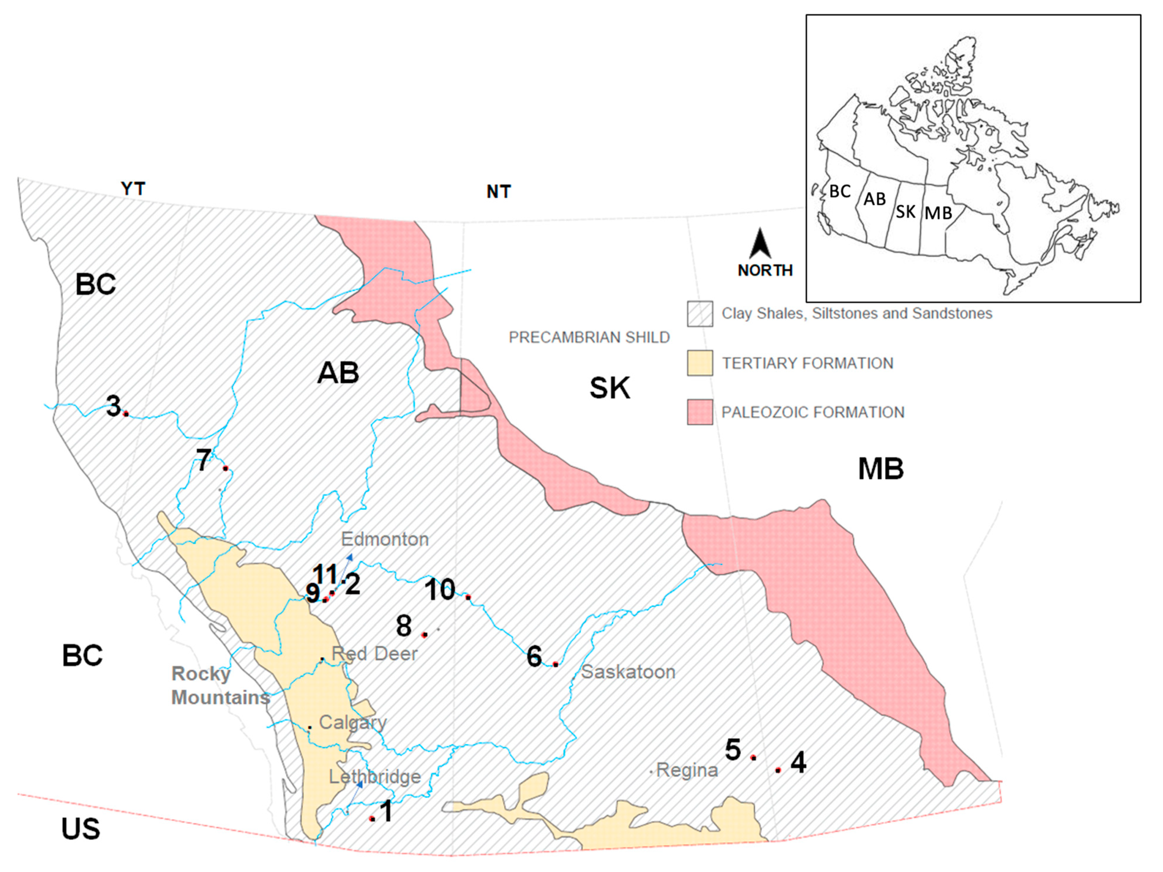
The Canadian Interior Plains (Interior Plains) occupy an area that includes portions of northeastern British Columbia, most of Alberta, central and southern Saskatchewan, and southwestern Manitoba [
1] (
Figure 1, adapted from [
1,
2]). Landslides are common within deeply-incised valleys in the Interior Plains, and the high susceptibility to landslides within this region has been previously documented [
3,
4]. Importantly, a number of these landslides have impacted critical infrastructure, including railways, roads, bridges, pipelines, and urban areas [
5].
It is the authors’ experience that understanding landslide kinematics, their characteristics, and contributing factors is crucial for decision-making regarding mitigation strategies and resource allocation for infrastructure projects and urban development. It is also understood that these characteristics depend on the geomorphology of the area, regional climate and interaction with water bodies and anthropogenic activity. In this regard, continuous updating of our understanding of landslide characteristics, kinematics, and contributing factors in the Interior Plains will provide insights for estimating landslide susceptibility that can inform land use planning, and the location and operation of transportation infrastructure.
Different provinces keep landslide records and maps of the provinces [
6,
7,
8,
9]. In this study, a landslide database within the Interior Plains has been initiated, that includes details from a geotechnical perspective and with particular emphasis on compound and translational landslides, that will allow an updated understanding of their kinematics and contributing factors. This paper synthesizes the failure mechanisms, triggering events, and contributing factors associated with 11 of these landslides. A detailed discussion of five of these landslides is presented in this paper, with particular emphasis on the Chin Coulee and Lesueur landslides, to provide the reader with an appreciation of the phenomena. The locations of the 11 landslides are shown in
Figure 1.
This paper does not present a landslide susceptibility analysis but does synthesize and discuss the commonalities of these landslides in terms of geomorphology, kinematics, possible movement triggers, and any seasonal acceleration and deceleration periods. Furthermore, the paper highlights some important implications of these observations for practitioners in the Interior Plains of Canada, and serves as an illustrative example of landslide case study synthesis and analysis that can be deployed elsewhere. As this review and synthesis focuses on regional commonalities between landslide events, an analysis of specific climatic triggers is out of the scope of this paper. Furthermore, this work is qualitative given the length of the current database, and the review, synthesis and discussions of previously published work provide insights in a qualitative manner.
2. Materials and Methods
The synthesis presented in this paper, on which the conclusions are based, was performed through the review of published information available to the public, including journal articles, conference proceedings and reports, as referenced in the text (
Section 3 and
Section 4, results sections). A summary of the references utilized per case study is presented in
Section 4.
The method for selecting review cases followed (1) literature search through relevant journals and Canadian conference proceedings, and (2) discussions based on the practical experience of the authors in the region of study.
(1) was achieved through focused searches in journal and conference repositories with key words that included “landslide”, “susceptibility”, “translational”, “compound”, amongst others; and by following the references. Utilized in relevant publications. This was also guided by experience of the authors in managing landslide hazards along transportation corridors in western Canada. This experience and the results from (1) were the basis for discussion in (2) above.
The review then focused on commonalities for the case studies reviewed such that insights could be derived from the factual observations.
3. Results: Geologic Context of the Interior Plains
A review of the overall geologic context, morphology and climate of the region is important to understand the contributing factors to the development of landslides. This section presents the overall context, common to the case studies evaluated, in order to identify such landslide contributing factors.
The climate along the entire region of study can vary from dry semi-arid to more humid continental, with annual precipitation about 300 to 500 mm, although can be highly variable locally due to the occurrence of localized intense precipitation events. Temperatures can reach 40 degrees Celsius in the summer months and go lower than −45 degrees in the winter months.
3.1. Bedrock
Bedrock in the Interior plains originated as fine-grained marine or nonmarine sediments deposited during the Cretaceous period [
1]. They occupy almost the entire Interior Plains area and are poorly consolidated, characterized by flat-lying clay shales, interbedded by siltstones and sandstones.
The clay shales are usually in thrust and highly fractured due to glacial overriding. The clay shales present very low hydraulic conductivity resulting in high pore pressure within the mass, due to the high clay fraction and the presence of bentonite. Very often, thin layers of bentonite or weak coal seams are encountered interbedded in the Cretaceous bedrock, which substantially affects its engineering properties by introducing significant anisotropy [
1]. For example, in the Edmonton area, the average thickness of coal seams ranges from a few centimeters to meters, and bentonitic seams from a few millimeters to less than one meter [
10]. The bentonite originates from volcanic ash that spread over the sedimentary rocks as admixtures and consists mainly of highly expansive montmorillonite [
11]. The strain-weakening characteristics of the thin bentonite layers, where exposed by the deeply-incised valley walls, present a critical plane of weakness which controls the geometry and kinematics of many landslides in the region.
Preglacial deposits of sands and gravels, typically within channels incised in bedrock, are also common, as is the case of the Empress Formation.
Tectonic structures that could be present in bedrock are not a common contributing factor in the formation of landslides in this area (this is not a highly seismic area, and these landslides are not defined by rock structures associated with faulting).
3.2. Glacial Deposits
The most abundant surficial deposits encountered in the Interior Plains are the glacial deposits from the Pleistocene and are comprised mainly of till, glaciofluvial, and glaciolacustrine materials [
1].
The till deposits are most abundant and are composed generally of equal amounts of sand, silt, and clay [
2], and their behavior is significantly influenced by high clay content [
1]. The second most abundant surficial deposits found in the interior plains are the glaciolacustrine deposits, for example those associated with Glacial Lake Edmonton (Edmonton area) and Glacial Lake Regina in south-central Saskatchewan. They are comprised mostly of clay and silts; however, sands can be encountered in some areas. Glaciofluvial deposits are also present, composed mainly of sands and gravels, having clay content as an important feature [
1].
3.3. Non-Glacial Deposits
Nonglacial deposits are from the Holocene, Tertiary, and Cretaceous and are found in just a few parts of the region in depressions and as eolian sediments. In depressions, they are characterized as clastic and organic sediments, similar to organic-rich mud and peat. In larger valleys, they consist of gravels and sands, silts and clays, and in smaller valleys primarily of colluvium. The eolian deposits consist basically of sand and silt encountered as loess formed by sand dunes in deltas or over coarse glaciolacustrine deposits [
1].
3.4. Meltwater Channels
Meltwater channels formed under the ice sheets as these retreated, incised into the flat-like surface about 10,000 years ago [
12]. These are widespread in the Interior Plains and are one of the mechanisms responsible for the formation of river valleys and depressions in this region [
1]. The valley downcutting action during meltwater channel formation is associated with valley slope elastic rebound that led to strain localization along weak seams in the valley walls, mobilizing their shear strength to or near residual values. It has also been suggested that valley walls in the Interior Plains are still in a rebound state [
13].
4. Results: Examples of Landslides in the Canadian Interior Plains–Mechanisms, Kinematics and Triggers
This section briefly describes some of the landslides in the Interior Plains, where the landslide mechanisms, triggers and contributing factors are closely related to the material behavior, as governed by its anisotropic engineering properties, such as stress and hydraulic conductivity anisotropy, expansive nature, and low residual strengths (due to the presence of bentonite or coal). This knowledge is considered crucial when solving engineering problems in this region of Canada and provides context to the more detailed description of the Lesueur and Chin Coulee landslides. A summary of the failure mechanisms, contributing factors, trigger events and dimensions of the 11 landslides is presented in
Table 1.
4.1. Devon Landslide
The Devon Landslide is 12 m high and 23 m long. It occurred in the fall of 1965 in the town of Devon, Alberta, about 20 km southwest of Edmonton. The landslide is adjacent to Highway 60, where the road crosses the North Saskatchewan River. Excavation associated with highway work occurred during the summer of 1965, steepening the valley wall at that location from a previous slope angle of 12° to approximately 20°. It is noted that tension cracks had been observed near what would develop into the back scarp of the landslide [
10].
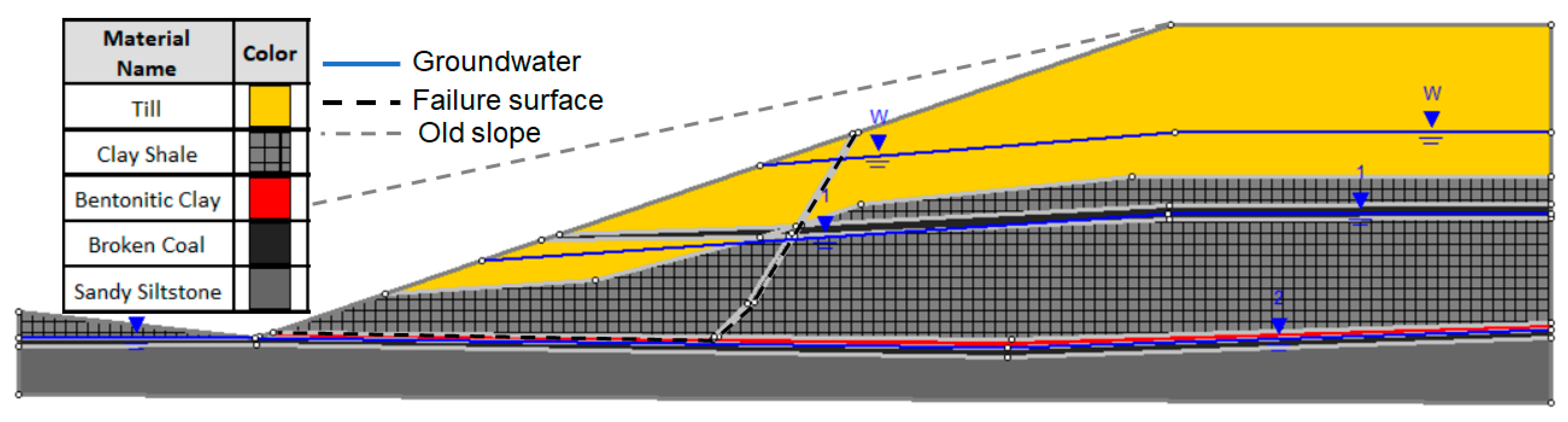
4.1.1. Geology and Stratigraphy
The stratigraphy at the site includes till deposits consisting of sandy and silty clay with thickness ranging from 4.5 m–6.0 m overlying bedrock. Underlying the till, the bedrock formation is comprised of a complex variation of non-homogeneous materials with two highly fractured coal layers, and two layers of soft bentonitic clay. The failure surface was inferred to be located in a lower bentonitic clay layer within the bedrock, with thickness ranging from 2.5 cm to 30 cm. The bentonite was underlain by coal and overlain by clay shale in a broken state, significantly iron-stained and wet [
10]. The strata of the site can be divided into four units: bentonitic clay, weathered clay shale, weathered sandy siltstone, and un-weathered sandy siltstone, as shown in
Figure 2. The weathered materials were classified as softened and the un-weathered sandy siltstone as having unsoftened strength.
Two distinct piezometric water levels were found in the bedrock, in addition to a perched water table located about 3 m below the ground surface. The lower piezometric level was located just below the failure surface within the fractured coal, approximately 17 m below ground at the back slope surface. The upper piezometric water level was defined to be 7.5 m deep from the back slope ground level in the upper fractured coal layer. Water was observed flowing from both highly fractured coal layers at the slope face [
10], suggesting they acted as drainage paths supporting a series of piezometric elevations.
4.1.2. Landslide Mechanisms, Triggers and Factors
The mechanism of the Devon landslide was interpreted as a non-circular slip surface defined by a basal, near-horizontal weak bentonitic layer, and a back scarp to the surface. The mobilized strength of the bentonitic layer was back-analyzed, and represented a friction angle of 8° with no cohesion. Unfortunately, no information was reported on the landslide displacement rates. Predisposing factors for the landslide included the weak bentonitic clay layer that defined the basal rupture surface, and softening of the overlying materials due to the fractured state of the rock and the groundwater pressures. It is possible that the excavation work for Highway 60 generated a concentration of stresses associated with the steeper cut angle than surrounding slopes, triggering mobilization of the residual strength of the bentonitic layer, compounded by a loss of buttressing of the slope [
10].
4.2. Peace River Highway Bridge Landslide
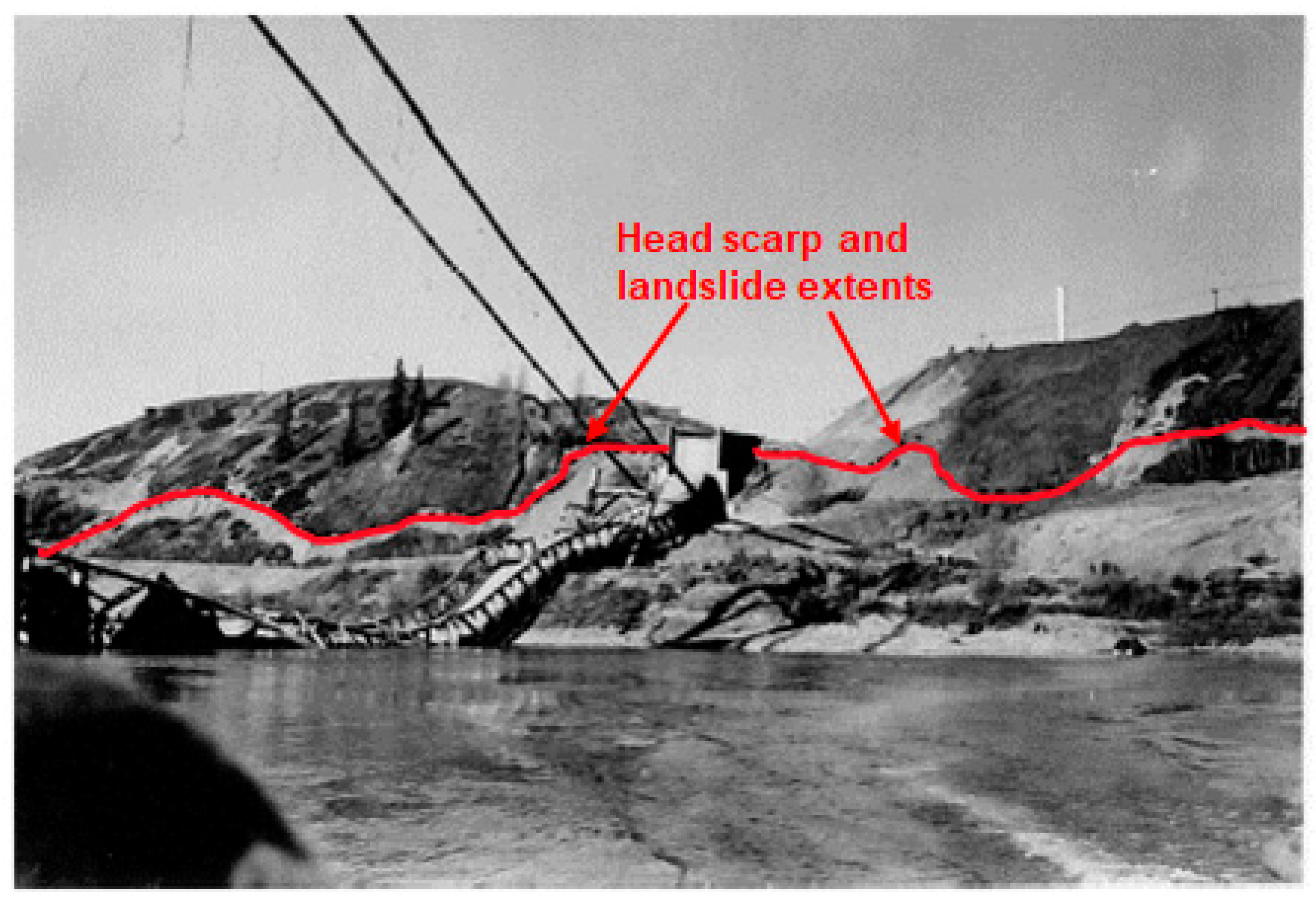
On 16 October 1957, the Peace River highway bridge at Taylor, BC, collapsed due to a landslide that developed at the north bank of the river, approximately 15 years after its initial construction. Following construction of the bridge, surface erosion leading to scour was reported under the foundation pad of the bridge’s north abutment. Intense precipitation was found to exacerbate the scour erosion. It was also reported that prior to the landslide, the bridge structure had shown significant settlement and horizontal displacement. Surveys had measured displacements of the north gravity anchor block of the suspension bridge in the order of 50 cm prior to failure [
13,
21].
4.2.1. Geology and Stratigraphy
The bridge structure was supported by clay shale with high montmorillonite content, interbedded with coal seams, siltstones, and sandstones. The surficial deposits consist of coarse clean sand and gravel, with some silt content in a flat terrace that overlays the clay shale. The local clay shale is highly plastic and part of the Upper Cretaceous Shaftesbury Formation [
21]. The contact between the sediments and bedrock was approximately 30 m deep [
13]. The intact clay shale behaved as heavily over-consolidated material according to consolidation test results. In its weathered condition, its strength properties were considered to have zero cohesion and a friction angle of approximately 31° [
13].
4.2.2. Landslide Mechanisms, Triggers and Factors
Landslide initiation was a combination of geomorphological, anthropogenic, and physical processes and factors. The clay shale at the contact with the terrace was found to be in a weakened state, with evidence of significant groundwater seepage, and it was interpreted as the zone where the slip surface developed [
13]. The failure was mostly associated with the expansive characteristics of the bentonitic clay shale when confinement is reduced and in contact with water. The swelling of this material was likely triggered or accelerated by the stress relief caused by the excavation of 15 m of overburden (terrace gravels) during the construction of the highway bridge. The excavation of the terrace materials also allowed for ingress of water to the clay shale, which in the 15 years leading up to failure, weathered the shale to a high plastic clay [
21]. It was interpreted that the loss of strength of the clay shale following bridge construction was the major cause of the landslide [
21]. The kinematics of failure were not explicitly described in [
13], but according to the landslide description, it can be inferred it developed as a compound landslide.
Figure 3 from [
21] shows the north abutment of the collapsed bridge, and the landslide extents.
4.3. Whitemud Road Landslide
The Whitemud road landslide in Edmonton, Alberta, occurred on 23 October 1999. Displaced trees and minor debris at river level had been observed on air photos prior to the major landslide event. Ground cracking at a park trail on the valley wall and residential lots backing onto the top-of-bank were also reported before the landslide occurrence [
22].
4.3.1. Geology and Stratigraphy
At the location of the Whitemud Road landslide, bedrock in the North Saskatchewan River Valley consists of interbedded layers of clay shale, and sandstones with bentonitic seams. The sandstones vary from low plastic, sandy clay to weak soft rock. The clay shales and clay shale are considered extremely weak to very weak, massive with high plasticity, and without fissility. The bentonitic seams have thicknesses varying from 5 to 40 cm [
22].
The surficial deposits consist of fill, clay, sand, and till in contact with the bedrock. The till has a thickness of 8 to 10 m and consists of a clay matrix containing local bedrock and carbonate fragments of sand size. The Holocene sand deposits overlie the till with a thickness of 30 to 35 m and were documented to be in a dense state. The upper glaciolacustrine silty clay has a thickness of 1 to 6 m, soft to medium stiff, and has low to intermediate plasticity. Sandy clay fill was found at about the same level as the clay. The fill materials were used to regrade the terrain for urban development, and likely consisted of re-worked native materials [
22].
4.3.2. Landslide Mechanisms Triggers and Factors
The landslide evolution was inferred as initiating with a local failure at the toe of the slope resulting from bedrock softening and stress relief [
23]. Following these initial movements, the groundwater level increased in 1999, resulting in the dilation of the bedrock and resulting in significant slope movements, leading to the main head scarp (active wedge) [
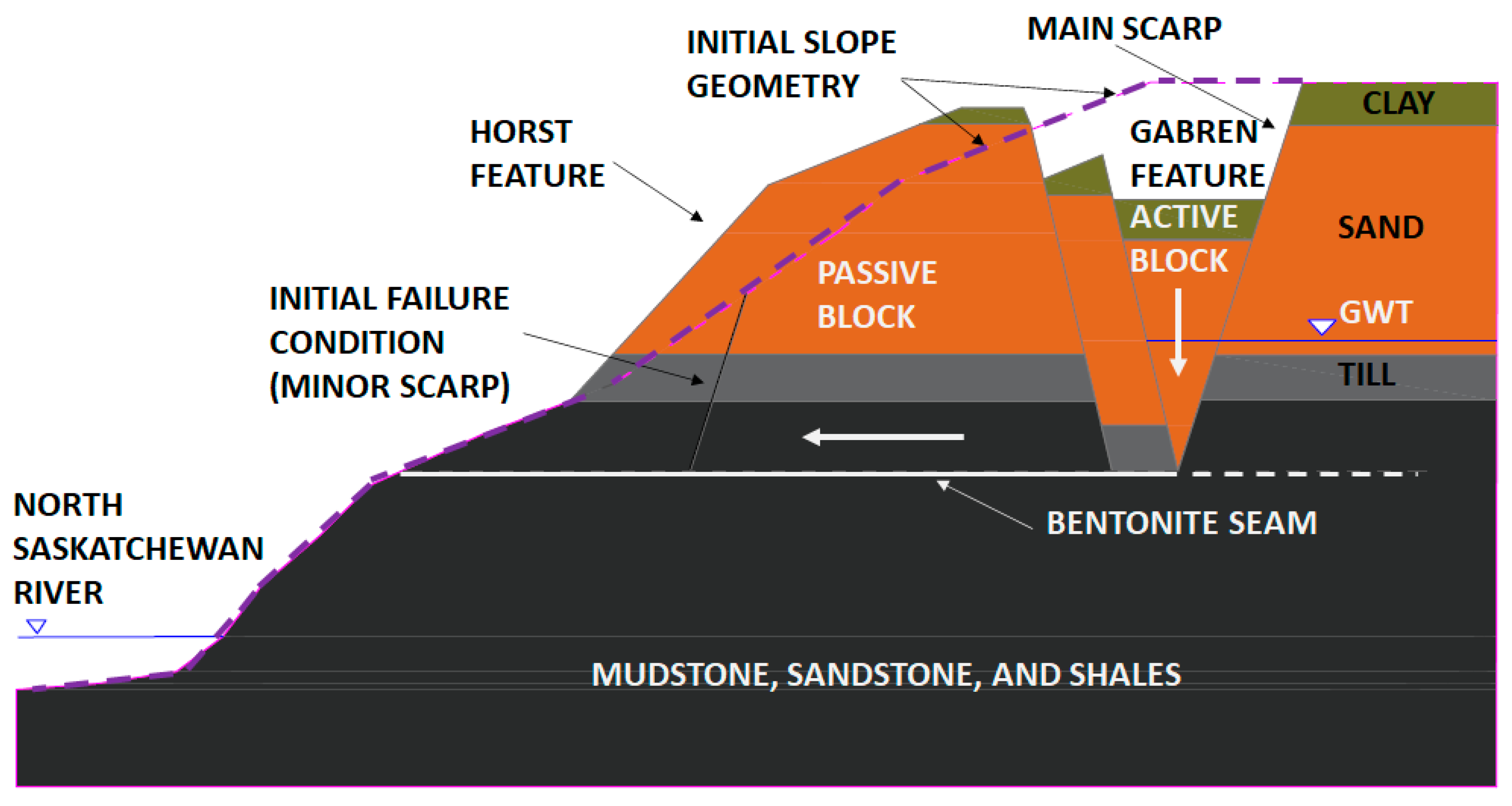
22]. The failure then developed as a translational landslide sliding along a weak bentonitic seam, with horst and graben features.
Figure 4 illustrates the inferred kinematics of the landslide during the initial stages of movement, which consists of passive block sliding in a horizontal direction along the bentonite layer, allowing the active wedge to move in a predominantly downward direction (after [
22]). Subsequent movements and weathering have led to the disaggregation of the failure structure.
The main trigger event of the landslide was inferred to be associated with the groundwater seepage discharge within the slope mass [
22]. This seepage discharge was found to be occurring in the overall area of the landslide due to the glacial kame features and sand channel within the till. In addition, the seepage quantities were likely increased due to the urban development along the top of the bank; it was concluded that the seepage discharges caused the softening of the material strength due to the increased porewater pressures caused by the seepage discharge and its associated de-stabilizing effects [
23]. It is noted that the location of the basal rupture surface being well above the river prevented the formation of a buttress of landslide deposits in the zone of accumulation (material fell towards the river rather than accumulated at the toe). If the sliding material had remained at the toe, in the form of a buttress to the slope; this could have provided some stabilizing forces at the toe after failure initiated.
4.4. Lesueur Landslide
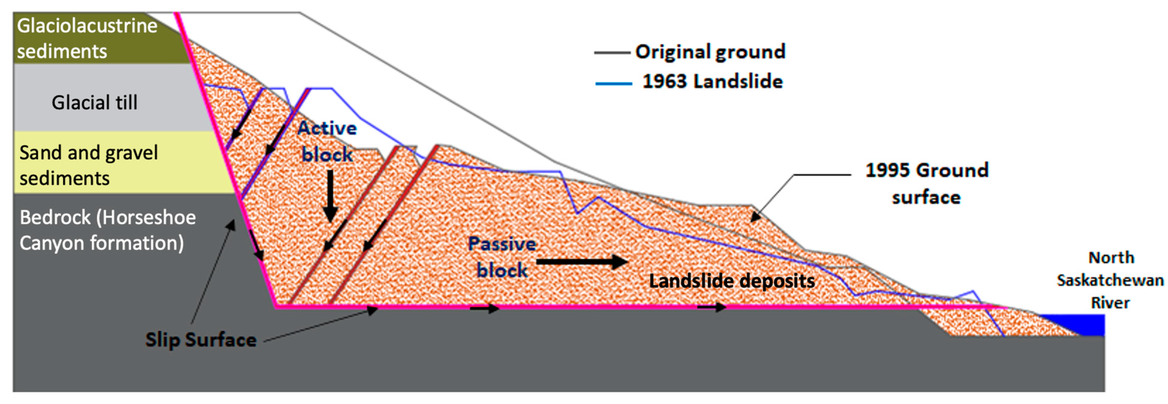
The Lesueur landslide took place in September 1963 on the North Saskatchewan River in the northeast of the Edmonton area. The landslide occurred at the north bank in a curved section of the river and the volume of the displaced material was estimated approximately 760,000 m
3 of debris that moved in a complex mode at different times. The movements were first noticed with the detection of small cracks on the terrain, reaching the basement wall of the Lesueur House. The first developed head scarp was 1.8 m high and it increased to 6.7 m high after 12 h, leaving part of the foundation of the house cantilevered over the scarp [
20].
The dimensions of the landslide were defined as 50 m wide at the head scarp, approximately 150 m at the toe, and according to the cross-section in
Figure 5 the original slope was approximately 77 m long, from the head scarp to the toe. The depth of the slip surface was inferred to be 31 m deep according to a borehole investigation [
20]. The slope angle before the failure was not documented, but it was estimated as approximately 27° to the horizontal based on slopes in the vicinity of the area and photographic records.
4.4.1. Geology and Stratigraphy
The surficial geology of the site which defines the upper half of the slope was defined as glaciolacustrine silty sand at the surface, overlying Pleistocene till which sits over pre-glacial Saskatchewan sands and gravels. The bedrock which was encountered below the sand and gravel forms the lower half of the slope. This material is from the Horseshoe Canyon Formation which is comprised of clay shale with interbeds of bentonitic clay shale, bentonite, and a coal seam over a bentonitic sandstone [
20].
4.4.2. Landslide Mechanisms, Triggers and Factors
At the time of the slope failure, observations of the features of the landslide reveled the failure condition of the ground (internal shears) which were exposed in head scarps, aiding interpretation of the landslide kinematics [
20]. Based on these observations, the exposed head scarps evidenced two ancient, inactive landslides that might have occurred thousands of years ago (approximately 7000 years ago). Usually, in the clay shale formation, older landslides occurred during the erosional processes caused by the last deglaciation (pre-shearing by ice sheets overriding the bedrock, followed by rapid incision of melt-water channels). After the ancient formation of the valley walls and initial instability processes, the landslides tend to become stable, until new triggering events are imposed on the slope. This concept was understood as a cycle of changes, following [
24].
The Lesueur landslide was inferred to be reactivated by ongoing erosional processes and weathering, likely with contribution of anthropogenic activities. The Lesueur Landslide was last triggered by erosion over the terrace at the toe of the slope, reducing the buttress at this location, which allowed softening of the bedrock slope following stress rebound. This erosional process at the terrace was associated with coal mining activities that were happening at that time, and river action at the riverbank (toe of the slope). In addition, the eastward expansion of the city of Edmonton was inferred to be another anthropogenic triggering event, as the natural surface runoff and groundwater level is usually impacted due to urban development. These activities usually also cause in situ stress changes contributing to landslide activity.
According to [
20], the Lesueur landslide is classified as a complex deep seated failure with compound and retrogressive translational movements. The compound features were understood from graben and horst features as it can be seen in
Figure 5. The failure kinematics, in more detail, were inferred to initiate (stage 1) with a rapid movement triggered by an active wedge (graben) settling in the upstream area of the slope, pushing the passive wedge as a horst-like feature in the sub horizontal direction towards the river [
20]. The second stage was defined as the graben-like feature moving at a slow to very slow rate pushing the passive wedge into the Saskatchewan River. The movements of the second stage (stage 2) continued until 1995 when the graben stopped displacing downwards at the crown of the slope. During the last stage (stage 3), the lower wedge halted when it was no longer being driven towards the river by the graben feature; however, local instabilities still occurred caused by river erosion of the toe. This erosion corresponded to the section of the river being encroached upon by the lower wedge, and it steepened the toe of the slope, therefore triggering local circular failures [
20]. Continued landslide movements in the third stage are believed to be triggered by river erosion at the toe of the slope and by a rapid drawdown mechanism [
20]. An important factor was the mobilization of the clay shale residual shear strength due to the presence of bentonite, where the horizontal rupture surface was inferred to be located, as can be seen in
Figure 5.
The landslide movements were assessed by a combination of air photos, and landslide surveys in 1963, 1985 and 1992. It was detected that the river width was significantly reduced by the advance of the slope toe into the river, and the slope crest was retrogressing. After the Lesueur landslide in 1963, more recent surveys were undertaken in the years of 1985 [
25] and 1992 [
26]. Those surveys were combined with existing data from the time of the 1963 failure, and it was confirmed that the slope morphology underwent changes due to continuing movements since the 1963 landslide [
20]. The head scarp was inferred to have retrogressed approximately 24 m and the toe of the slope had advanced 13 m towards the river. [
20] provided rates of movements in different time spans. The rate of movement in the first year after the failure was 10 m/year, and in July 1995 was 3 m/year. These rates of movements fall in the moderate to slow velocity classes according to [
27].
According to the kinematics described above, the Lesueur landslide movements present similar characteristics to the Whitemud Road landslide, also in the Edmonton area, defined as landslide number 2 in
Table 1.
4.5. Chin Coulee Landslide
The Chin Coulee landslide is located approximately 60 km from Lethbridge in southern Alberta. The landslide is within a reservoir that was filled in the 1950 s to supply surrounding farms with irrigation water. Highway 36 was relocated from the toe of the slope to its crest to allow reservoir filling. Between the 1960 s and 1970 s, the reservoir was completely full, and the highway underwent a new realignment for local traffic improvements [
28]. The new realignment required shifting the road southward and placing a clay fill berm on the slope crest. Since then, the slope has slowly deformed, undermining the road continually. Landslide monitoring is in place and road observations and maintenance occur with some frequency.
4.5.1. Geology and Stratigraphy
Bedrock consists of flat-lying upper cretaceous clay shales with interbeds of sandstones, siltstones, and shales thinly layered with beds of non-marine coal and bentonite. The interbeds are gently dipping towards the north [
29,
30]. According to [
31], the local bedrock is generally extremely weak; however, a weak and fractured coal zone is encountered at a depth of about 38 m (measured from the centre of the slope) to 17 m (measured closer to the reservoir, towards the toe). The surficial geology is comprised of Pleistocene sediments including glacial till, 35 m thick, very stiff to hard, and with a low to medium plasticity clay matrix containing trace amounts of fine gravel.
Groundwater seepage was encountered in sandier pockets within till (15 m below ground at the slope crest), and in the fractured coal layer within the shale. Both formations discharge groundwater towards the reservoir [
31]. The reservoir water level variation and precipitation have been shown to have a direct effect on measured groundwater levels. Groundwater measurements taken in the late 1990 s suggested that pore water pressures near the head scarp of the landslide are controlled by the regional groundwater regime discharging from the sandier material; from the middle of the slope towards the toe, the pore water pressure is controlled by the reservoir water elevation and precipitation ingress. The average groundwater elevation is illustrated graphically in
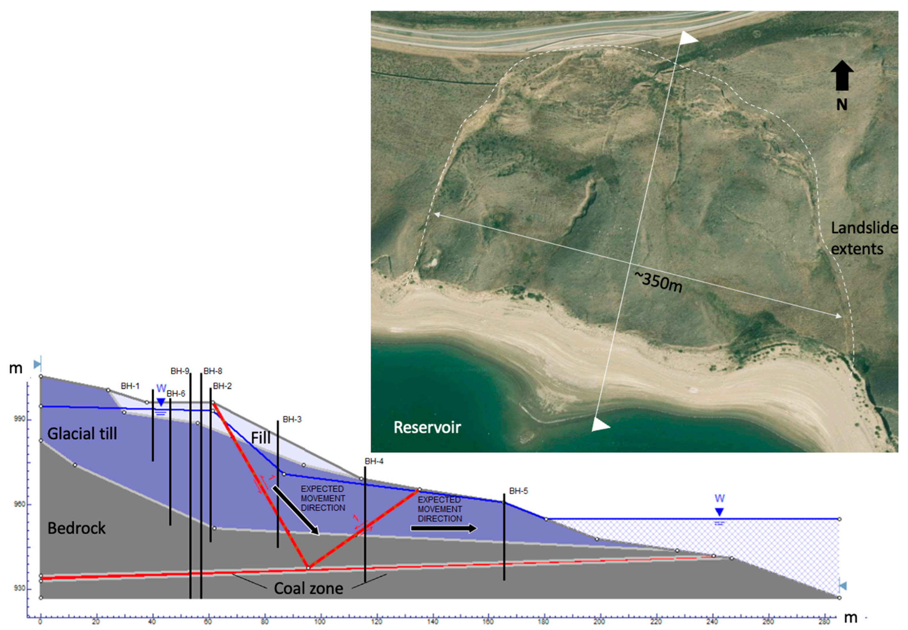
Figure 6. According to Alberta Transportation, the groundwater table can fluctuate by approximately 8 m.
4.5.2. Landslide Mechanisms, Triggers and Factors
The Chin Coulee landslide is a retrogressive compound landslide, with its failure surface deep-seated in a highly fractured clay shale, sliding almost horizontally through a weak coal layer tilting slightly upwards, approximately 2° towards the reservoir. The landslide kinematics consist of an active wedge moving downwards and pushing a passive wedge towards the reservoir, at approximately 10 to 50 mm/year [
14,
32,
33,
34,
35].
Figure 6 illustrates the Chin Coulee landslide features in a typical cross-section. The sub-vertical red lines in this figure represent the failure surfaces between the active and passive wedges, sliding over the fractured coal, represented as a sub-horizontal red line [
14,
32,
35]. The landslide surface was updated from recent LiDAR scans (September 2021).
Geomorphological landslide development processes would have been associated with valley wall rebound due to river valley formation, leading to localized strains along the coal seam and mobilizing the residual strength of this material. [
35] compared slope movements using single frequency dGNSS against the reservoir water level variation between July 2018 and September 2019. They observed that seasonal displacement rates increased as the reservoir level decreased, and the landslide decelerated when the reservoir levels increased, consistent with drawdown effects.
It is plausible that the combined action of filling of the reservoir and the embankment fill required to accommodate the highway realignment acted as triggers for landslide initiation. The filling of the reservoir changed the groundwater regime within the slope and the road fill increased the driving forces over the failure surface. Other mechanisms could have a role in the rate of deformation after the landslide had initiated. These would include water infiltration during precipitation and spring thaw events, filling in tension cracks, and increasing lateral pressures as well as potentially increasing pore pressures at the basal sliding surface and thereby decreasing effective stress.
5. Discussion
Factors affecting the susceptibility to different landslide types have been identified and studied in many regions of the world (e.g., [
36,
37,
38,
39]), including translational and compound landslides (e.g., [
40,
41,
42]).
The 11 landslide case studies presented in
Table 1 are seated in the Cretaceous bedrock of the Interior Plains. Consequently, bedrock materials, surficial deposits, and groundwater regimes are similar. The presence of weak materials (e.g., bentonitic clays) and preferential drainage paths (e.g., coal seams) as sub-horizontal layers within the sedimentary formations, define the basal sliding surfaces of these landslides. These preferential rupture surfaces act to constrain the geometry of the slope failures, contributing to the development of active and passive wedges found in compound and translational landslides.
For all of the 11 landslides listed in
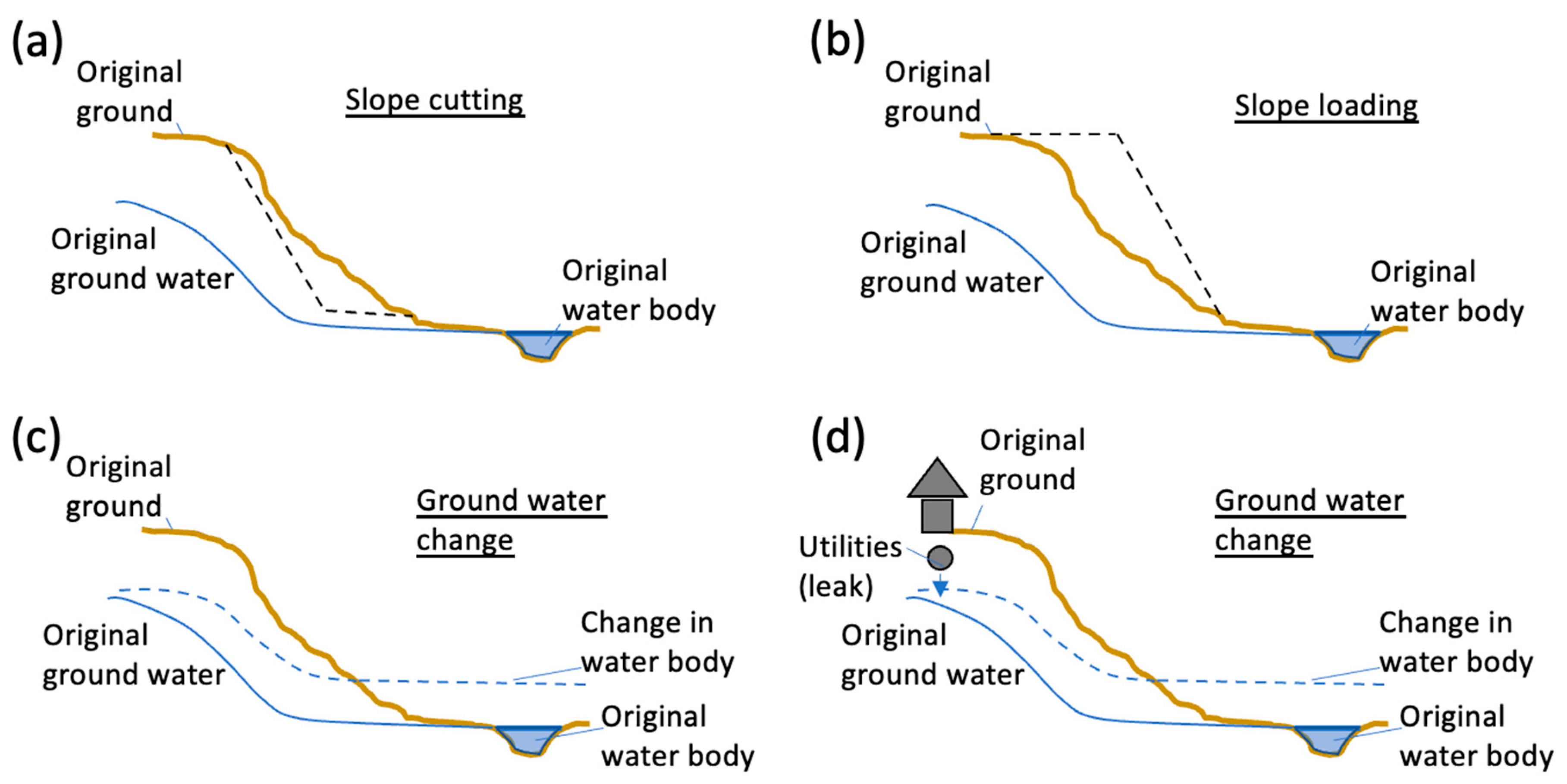
Table 1, including those described in this paper, anthropogenic modification of the top-of-bank and/or valley wall was a common contributing factor. These modifications included slope cutting, loading through the placement of infrastructure foundations or earth fill, and effects of urban development (e.g., changing drainage patters, changes in surface water infiltration and run off, changes in loading at the back of slopes). Schematics of examples of anthropogenic influence in the stability of valley slopes are illustrated in
Figure 7. It is noted that most well-documented landslides are those that have affected people, infrastructure, or economic activities. Therefore, a bias is expected towards reporting landslides where anthropogenic activity has occurred. However, these case studies suggest that human intervention leading to changes in the stress regime or groundwater patterns, even when seemingly benign compared to the dimension of the valley slopes, can trigger the development of instability on slopes that are marginally stable in this region.
It was also observed that the Chin Coulee and the Whitemud Road landslides demonstrated retrogressive behavior, with graben and horst features. It is likely that several others of the case studies could be of a retrogressive nature that has not yet developed or was not reported, as this is a common feature of compound and translational landslides elsewhere (e.g., in the Thompson River Valley in the province of British Columbia, Canada [
43]).
In this case, 10 of the landslides summarized in
Table 1 had a river at the toe, with the 11th, Chin Coulee, adjacent to a reservoir. Reservoir fluctuations and river erosion were reported as contributing factors for the initiation or acceleration of these landslides. High slopes in the Interior Plains are associated with deeply-incised river valleys, and river erosion is therefore a common precursory factor and potential trigger for landslides. The Chin Coulee landslide is a particular case where it was found that the movements had a close correlation with the reservoir water level fluctuation [
35]. Similar mechanisms have been identified for other compound and translational landslides elsewhere (e.g., the Ripley landslide in the Thompson River Valley in the province of British Columbia shows episodes of acceleration and deceleration as a response to river elevation [
44,
45]). Episodes of acceleration for some of the landsides have also been associated with precipitation events, which suggests marginally stable conditions that are disrupted by increases in pore water pressures at the basal sliding zone within the weak materials (in addition to lateral pressures exerted by water-filled tension cracks).
Based on the kinematics of failure, all 11 landslides are considered slow to very slow moving according to the classification in [
27], although it is noted that only four of the 11 case studies had landslide velocity information available. The Chin Coulee was reported to be moving between 10 mm and 50 mm/year [
14,
32,
35] and The Lesueur Landslide 10 m/year at the first year after failure and 3 m/year in 1995. Others with available landslide velocity information, which were not discussed here in detail, are the CN Mile 1914.4 (moving at 365 mm/year; No. 6 in
Table 1 [
16]) and the Borden Bridge landslide (moving at approximately 30 mm/year; No. 8 in
Table 1 [
18]).
6. Conclusions
This paper summarized the failure mechanisms, trigger events, and precursory factors associated with 11 well-known landslides in the Canadian Interior Plains. Five landslides, the Devon, Peace River Bridge, Whitemud Road, Lesueur and Chin Coulee landslides, were discussed in some detail. A common characteristic of these landslides is their kinematics of failure, characterized by active wedge and passive block, moving along a near-horizontal rupture surface of weak material. Landslides in the Interior Plains are generally associated with the mobilization of residual strengths on weak layers within the sedimentary bedrock, in many instances triggered by the increase in pore water pressure and changes in stresses from human activity. An important contributing factor is the fluctuation in river (and reservoir) levels at the toe of these slopes, and precipitation events, as evidenced by episodes of reactivation or acceleration. Several of the landslides have also shown retrogressive behavior.
The synthesis of these common characteristics allows for identification of important site-specific aspects when evaluating infrastructure projects on, or in the vicinity of, valley slopes in the Interior Plains. Insights presented herein can be used for estimating landslide susceptibility, and informing land use planning, and the location and operation of critical infrastructure. The synthesis in this paper can benefit practitioners in this region of Canada, for understanding landslide susceptibility in the region and setting an example of landslide case study synthesis and analysis that can be deployed elsewhere.
Author Contributions
Conceptualization, R.M. and C.G.; formal analysis, L.B.; methodology, L.B.; project administration, R.M; supervision, C.G., K.T. and R.S.; validation, C.G., K.T. and R.S.; writing—original draft, L.B. and R.M.; writing—review and editing, C.G., K.T. and R.S. All authors have read and agreed to the published version of the manuscript.
Funding
This research was funded by Klohn Crippen Berger and the Natural Sciences and Engineering Research Council of Canada (NSERC), grant number CRDPJ 543429-19.
Data Availability Statement
Not applicable.
Acknowledgments
The authors want to acknowledge Klohn Crippen Berger and Alberta Transportation for the time invested in the research reported in this paper and for making existing reports and their expertise available for this research.
Conflicts of Interest
The authors declare no conflict of interest.
References
- Klassen, R.W. Quaternary geology of the southern Canadian Interior Plains. In Quaternary Geology of Canada and Greenland; Fulton, R.J., Ed.; Geological Survey of Canada: Ottawa, ON, Canada, 1989. [Google Scholar]
- Mollard, J.D. Regional landslide types in Canada. Rev. Eng. Geol. 1977, 3, 29–56. [Google Scholar]
- Bobrowsky, P.T.; Dominguez, M.J. Landslide Susceptibility Map of Canada; Geological Survey of Canada: Ottawa, ON, Canada, 2012. [Google Scholar]
- Kelly, A.J.; Sauer, E.K.; Christiansen, E.A.; Barbour, S.L.; Widger, R.A. Deformation of the Deer Creek bridge by an active landslide in clay shale. Can. Geotech. J. 1995, 32, 701–724. [Google Scholar] [CrossRef]
- Porter, M.; Van Hove, J.; Barlow, P.; Froese, C.; Bunce, C.; Skirrow, R.; Lewycky, D.; Bobrowsky, P. The estimated economic impacts of prairie landslides in western Canada. In Proceedings of the 72nd Canadian Geotechnical Conference, St. John’s, NL, Canada, 29 September–2 October 2019; p. 8. [Google Scholar]
- Davies, M.R.; Paulen, R.C.; Hickin, A.S. Inventory of Holocene Landslides, Peace River Area, Alberta (NTS 84C); EUB/AGS Geo-Note 2003-43; Alberta Energy and Utilities Board: Edmonton, AB, Canada, 2005; p. 30. [Google Scholar]
- Pawley, S.M.; Hartman, G.M.D.; Chao, D.K. Relative Landslide Susceptibility Model of the Alberta Plains and Shield Regions; AER/AGS Map 605, scale 1:1 000 000; Alberta Energy Regulator: Edmonton, AB, Canada, 2016. [Google Scholar]
- Blais-Stevens, A.; Behnia, P.; Kremer, P.; Kung, R. Landslide susceptibility mapping of the Sea to Sky transportation corridor, British Columbia, Canada: Comparison of two methods. Bull. Eng. Geol. Environ. 2012, 71, 447–466. [Google Scholar] [CrossRef]
- Baldwin, J.R. Development of a GIS-Based Landslide Management System for Western Manitoba’ Highway Network. Master’s Thesis, University of Manitoba, Winnipeg, MB, Canada, 2007. [Google Scholar]
- Eigenbrod, K.D.; Morgenstern, N.R. A Slide in Cretaceous Bedrock, Devon, Alberta; Manuscript for the Department of Civil Engineering; University of Alberta: Edmonton, AB, Canada, 1985. [Google Scholar]
- Thomson, S.; Hayley, D.W. The Little Smoky Landslide. Can. Geotech. J. 1975, 12, 379–392. [Google Scholar] [CrossRef]
- Fulton, R.J. Quaternary geology of the Canadian interior plains. In Quaternary Geology of Canada and Greenland; Geology of Canada Series no. 1; Fulton, R.J., Ed.; Geological Survey of Canada: Ottawa, ON, Canada, 1989. [Google Scholar]
- Hardy, R.M. The Peace River highway bridge–a failure in soft shale. Highw. Res. Rec. 1963, 17, 29–39. [Google Scholar]
- Deane, E. The Application of Emerging Monitoring Technologies on very Slow Vegetated Landslides. Master’s Thesis, University of Alberta, Edmonton, Canada, 2020. [Google Scholar]
- Moe, S.K.W.; Cruden, D.M.; Martin, C.D.; Lewycky, D.; Lach, P.R. Delayed failure of a river valley slope: Whitemud Road landslide. In Proceedings of the 59th Canadian Geotechnical Conference, Vancouver, BC, Canada, 1–4 October 2006. [Google Scholar]
- Bartz, J.R. Analysis and Design of Sheet Pile Ribs for Slope Stabilization. Master’s Thesis, University of Alberta, Edmonton, AB, Canada, 2017. [Google Scholar]
- Panesar, H.; Clifton, W.; Kelly, A.; Buchyski, M. Risk assessment of landslides impacting provincial Highway 8-06-40 near Tantallon, SK. In Proceedings of the Geoniagara, Niagara Falls, ON, Canada, 26–29 September 2021. [Google Scholar]
- Osback, J.; Clifton, D.; Panesar, H. The Borden Bridges–Remedial design for a large-scale deep-seated landslide. In Proceedings of the GeoNiagara, Niagara Falls, ON, Canada, 26–29 September 2021. [Google Scholar]
- Thomson, S.; Tweedie, R.W. The Edgerton Landslide. Can. Geotech. J. 1978, 15, 510–521. [Google Scholar] [CrossRef]
- Cruden, D.M.; Peterson, A.; Thomson, S.; Zabeti, P. Thirty-five years of activity at the Lesueur landslide, Edmonton, Alberta. Can. Geotech. J. 2002, 39, 266–278. [Google Scholar] [CrossRef]
- Thomson, S.; Cruden, D.M. The Peace River Bridge Collapse: Fourteen Illustrations of the Collapse of the Bridge over the Peace River at Taylor, British Columbia in October, 1957 with some Personal Recollections; Report for the Canadian Geotechnical Society: Edmonton, AB, Canada, 2010. [Google Scholar]
- Moe, S.K.W. Mechanism and Kinematics of Three Translational Slides along the North Saskatchewan River Valley, Edmonton. Ph.D. Thesis, University of Alberta, Edmonton, AB, Canada, 2008. [Google Scholar]
- AMEC Earth & Environmental Limited. Whitemud Road Landslide Geotechnical Assessment; Report for the City of Edmonton; AMEC Earth & Environmental Limited: Edmonton, AB, Canada, 2000. [Google Scholar]
- Hutchinson, J.M. The Response of London Clay Cliffs to Differing Rates of Toe Erosion; Building Research Establishment Current Paper 27/75; Building Research Establishment: Watford, UK, 1975. [Google Scholar]
- Cruden, D.M.; Tedder, K.H.; Thomson, S. Setbacks from the crests of slopes along the North Saskatchewan Valley, Alberta. Can. Geotech. J. 1989, 26, 64–74. [Google Scholar] [CrossRef]
- De Lugt, J.S.; Thomson, S.; Cruden, D.M. A suggested method for estimating setbacks from the crests of slopes on the Interior Plains in Alberta. Can. Geotech. J. 1993, 30, 863–875. [Google Scholar] [CrossRef]
- Cruden, D.; VanDine, D.F. Classification, description, causes and indirect effects. In Canadian Technical Guidelines and Best Practices Related to Landslides, a National Initiative for Loss Reduction; Open-File Report; Geological Survey of Canada: Edmonton, AB, Canada, 2013. [Google Scholar]
- AMEC Earth & Environmental Limited. Road Relocation Feasibility Highway 36: North of Chin Coulee Reservoir Stage 1 and 2; AMEC Earth & Environmental Limited: Calgary, AB, Canada, 2001. [Google Scholar]
- Thomson, S.; Morgenstern, N.R. Factors affecting distribution of landslides along rivers in southern Alberta. Can. Geotech. J. 1977, 14, 508–523. [Google Scholar] [CrossRef]
- Prior, G.J.; Hathway, B.; Glombick, P.M.; Pană, D.I.; Banks, C.J.; Hay, D.C.; Schneider, C.L.; Grobe, M.; Elgr, R.; Weiss, J.A. Bedrock geology of Alberta; Alberta Energy Regulator: Edmonton, AB, Canada, 2013. [Google Scholar]
- Golder Associates. Geotechnical Investigation HWY 36:02–Chin Coulee Landslide; Golder Associates: Calgary, AB, Canada, 1998. [Google Scholar]
- Macciotta, R.; Hendry, M. Remote sensing applications for landslide monitoring and investigation in western Canada. Remote Sens. 2021, 13, 366. [Google Scholar] [CrossRef]
- Deane, E.; Macciotta, R.; Hendry, M.; Grapel, C.; Skirrow, R. Historical aerial photographs and digital photogrammetry techniques to investigate the development and evolution of the Chin Coulee landslide in Alberta. In Proceedings of the GeoVirtual 2020, Proceedings of the Canadian Geotechnical Conference, Calgary, AB, Canada, 13–16 September 2020. 7p. [Google Scholar]
- Deane, E.; Macciotta, R.; Hendry, M.; Grapel, C.; Skirrow, R. Leveraging historical aerial photographs and digital photogrammetry techniques for landslide investigation—A practical perspective. Landslides 2020, 17, 1989–1996. [Google Scholar] [CrossRef]
- Rodriguez, J.; Deane, E.; Hendry, M.; Macciotta, R.; Evans, T.; Gräpel, C.; Skirrow, R. Practical Evaluation of Single-Frequency DGNSS for Monitoring Slow-Moving Landslides. Landslides 2021, 18, 3671–3684. [Google Scholar]
- Bentivenga, M.; Foresi, L.M.; Prestera, A.; Prosser, G.; Sabia, M. Structural setting at the front of a thrust and fold belt: The Craco area (Southern Apennines, Italy). Boll. Della Soc. Geol. Ital. 2005, 124, 367–376. [Google Scholar]
- Gueguen, E.; Bentivenga, M.; Colaiacovo, R.; Margiotta, S.; Summa, V.; Adurno, I. The Verdesca landslide in the Agri Valley (Basilicata, Southern Italy): A new geological and geomorphological framework. Nat. Hazards Earth Syst. Sci. 2015, 15, 2585–2595. [Google Scholar] [CrossRef] [Green Version]
- Ali, Y. A geotechnical study on the landslides in the Trabzon Province, NE, Turkey. Appl. Clay Sci. 2011, 52, 11–19. [Google Scholar]
- Mali, N.; Shukla, D.P.; Uday Kala, V. Identifying Geotechnical Characteristics for Landslide Hazard Indication: A Case Study in Mandi, Himachal Pradesh, India. Arab. J. Geosci. 2022, 15, 144. [Google Scholar] [CrossRef]
- Capitani, M.; Ribolini, A.; Bini, M. Susceptibility to Translational Slide-Type Landslides: Applicability of the Main Scarp Upper Edge as a Dependent Variable Representation by Reduced Chi-Square Analysis. ISPRS Int. J. Geo-Inf. 2018, 7, 336. [Google Scholar] [CrossRef] [Green Version]
- Guillard, C.; Zezere, J. Landslide susceptibility assessment and validation in the framework of municipal planning in Portugal: The case of Loures Municipality. Environ. Manag. 2012, 50, 721–735. [Google Scholar] [CrossRef]
- Segoni, S.; Pappafico, G.; Luti, T.; Catani, F. Landslide susceptibility assessment in complex geological settings: Sensitivity to geological information and insights on its parameterization. Landslides 2020, 17, 2443–2453. [Google Scholar] [CrossRef] [Green Version]
- Journault, J.; Macciotta, R.; Hendry, M.; Charbonneau, F.; Huntley, D.; Bobrowsky, P. Measuring displacements of the Thompson River valley landslides, south of Ashcroft, BC, Canada, using satellite InSAR. Landslides 2017, 15, 621–636. [Google Scholar] [CrossRef]
- Hendry, M.; Macciotta, R.; Martin, C.D.; Reich, B. Effect of Thompson River elevation on velocity and instability of Ripley Slide. Can. Geotech. J. 2015, 52, 257–267. [Google Scholar] [CrossRef]
- Macciotta, R.; Hendry, M.; Martin, C.D. Developing an early warning system for a very slow landslide based on displacement monitoring. Nat. Hazards 2016, 81, 887–907. [Google Scholar] [CrossRef]
| Publisher’s Note: MDPI stays neutral with regard to jurisdictional claims in published maps and institutional affiliations. |
© 2022 by the authors. Licensee MDPI, Basel, Switzerland. This article is an open access article distributed under the terms and conditions of the Creative Commons Attribution (CC BY) license (https://creativecommons.org/licenses/by/4.0/).


