1. Introduction
For the last few decades, there was a growing scientific interest in issues related to geoheritage, and many initiatives emerged worldwide. Geoheritage is an important natural resource that feeds the spread of geotourism around the world, and is rightly defined by Brocx and Semenniuk [
1] in this way: “Geoheritage encompasses global, national, statewide, and local features of geology, at all scales that are intrinsically important sites or culturally important sites offering information or insights into the evolution of the Earth; or into the history of science, or that can be used for research, teaching, or reference”.
Geoheritage can represent the first step towards the application of strategies useful for geoconservation and the enhancement of this inexhaustible natural resource, leading to the sustainable development of society [
1,
2,
3,
4,
5,
6,
7]. Geodiversity is fundamental in determining the characteristics of habitats, and contributes to shaping the scenic character of landscapes, which, most times, is the one that is more easily retained by our memory [
8]. An understanding of geoheritage could contribute to knowledge on geological and geomorphological characteristics, education, and public awareness on geoconservation and landscape protection issues. Moreover, the study of geosites promotes the process of developing laws on this topic, and the creation of databases useful for a better knowledge and conservation of geological heritage [
9,
10].
Unfortunately, awareness of this cultural wealth is still limited because the information available to the public is often specialized, and lacks significant emotional power. We should be aware that scientific approaches and languages are poorly understood by the general public because they are too technical, and the messages they convey are not absorbed. On the other hand, communication methods that directly address the emotional sphere seem to engage the public in a deep and meaningful way. Innovative strategies using the arts, gaming, theatrical improvisation, and interactive exhibitions are being developed [
11,
12,
13,
14]. If people are sensitized, technical information can be communicated more effectively. This work is aimed at testing alternative and innovative ways to engage non-expert audiences.
For several years, our research group worked on geoheritage and geotourism, following different communicative methods in areas of central Italy, particularly in the Marche and southern Emilia-Romagna regions. These areas were selected for their undoubted scientific and perceptive aesthetic value, and for the occurrence of many geosites of geomorphological interest, i.e., geomorphosites still untouched and characterized by various genetic and evolutive processes, and by an extraordinarily rich cultural and ecological context [
15,
16,
17,
18]. We emphasize that the term geomorphosite (contraction of “geomorphological site”) is used in the meaning of “landforms, active or inherited, having particular importance for the comprehension of the history of the Earth’s and its present or future evolution” [
19,
20,
21,
22]. The cultural landscape has to be considered as an additional value, defined by the multiplicity of elements that characterize a place, such as cultural, ecological, economic, and aesthetic criteria [
18,
23,
24,
25]. In the direction of sustainable development of geotourism, the accessibility of the sites, and the presence of accommodation, protected areas (natural reserves or parks), and teaching facilities were also investigated. Finally, vulnerability and the need for protection of geosites were underlined.
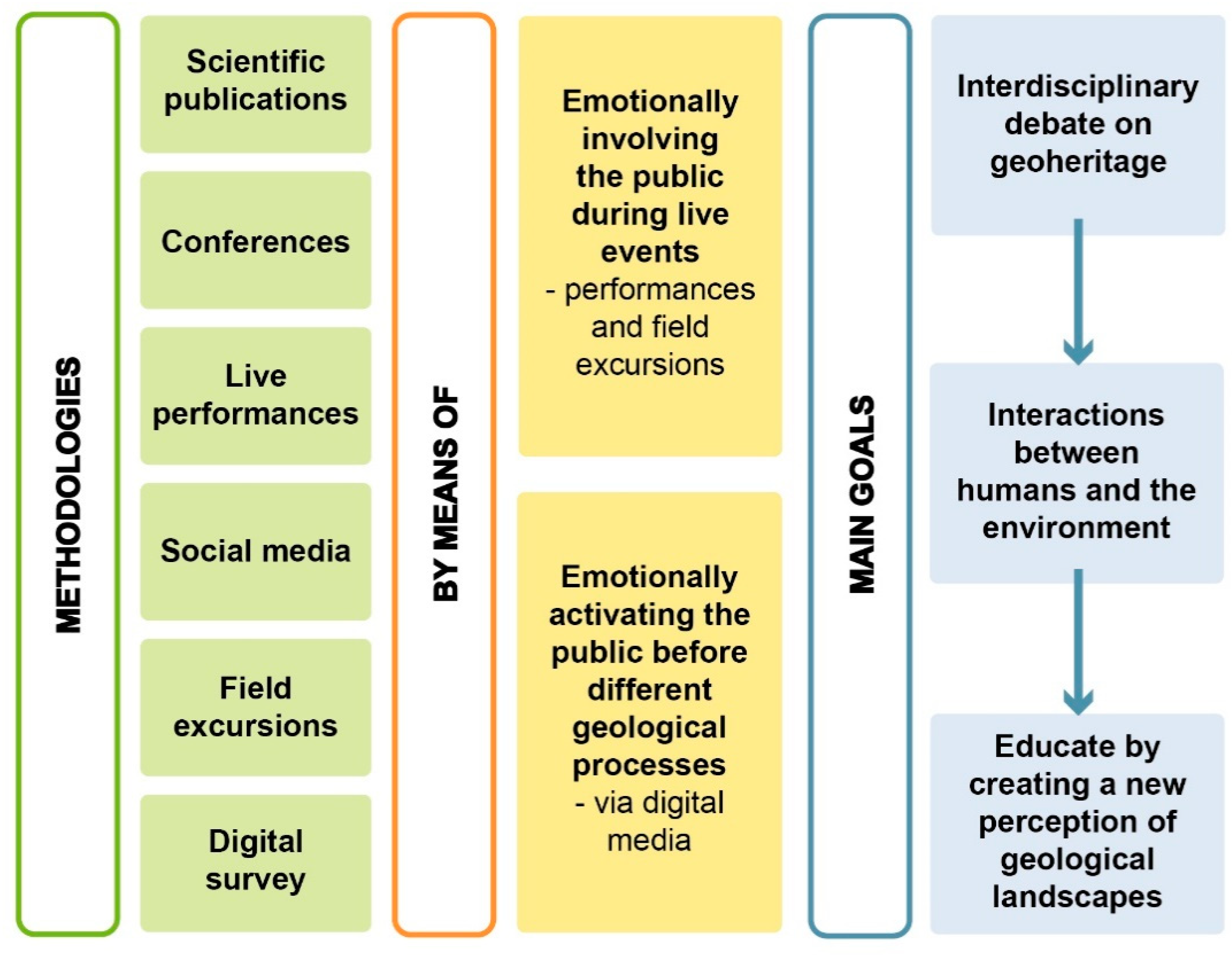
In this work, different communication methods, such as using forms of arts employed in popular publications, announcements through social media, conferences, live performances, and several modes of field excursions, always appealing to the emotional involvement of the public, were illustrated and compared. However, it should be noted that a quantitative monitoring of the incidence of these communication tools was carried out only during normal excursions, through on-site and online questionnaires, and interviews carried out with geotourists to assess their emotional, aesthetic–perceptive, and visual impact. Future forms of monitoring, not present in this paper, will consider the quantitative evaluation of the incidence of the coupling of musical, poetic, and serious game arts to traditional geotourist excursions. A touristic proposal that uses natural landscapes in a didactic or entertaining way, based on imagination and emotion about Earth’s history may, in fact, provide interesting developments [
26], especially considering that tourists and day visitors are attracted to crucial features such as environment and nature, educational tourism, culture, history, events, entertainment, and fun [
27]. There is significant evidence that emotional events can be stored more profoundly, and memorized for a longer time, than neutral events. In addition, this research concerns the identification of emotional activations of the public according to the geological process, through a digital survey.
The purpose is to combine and stimulate an interdisciplinary debate on various interconnected themes to the investigated sites, and reflect on the different interactions between humans and the environment, which, over time, favored and induced local and global changes in the physical landscape.
The main goal is to educate by creating a new perception of geological landscapes, starting with their physical beauty, then building on scientific research in cooperation with the arts, improving what we know about their problems and weaknesses, and addressing their culture and other strengths.
In addition, this work could help to inspire those geoscientists who have never considered collaborating with artists. The development of a unified culture would help to involve everybody in a more profound knowledge of the landscapes of the Earth and their delicate and complex mechanisms, preserving the wealth of our planet for future generations.
2. Investigated Areas
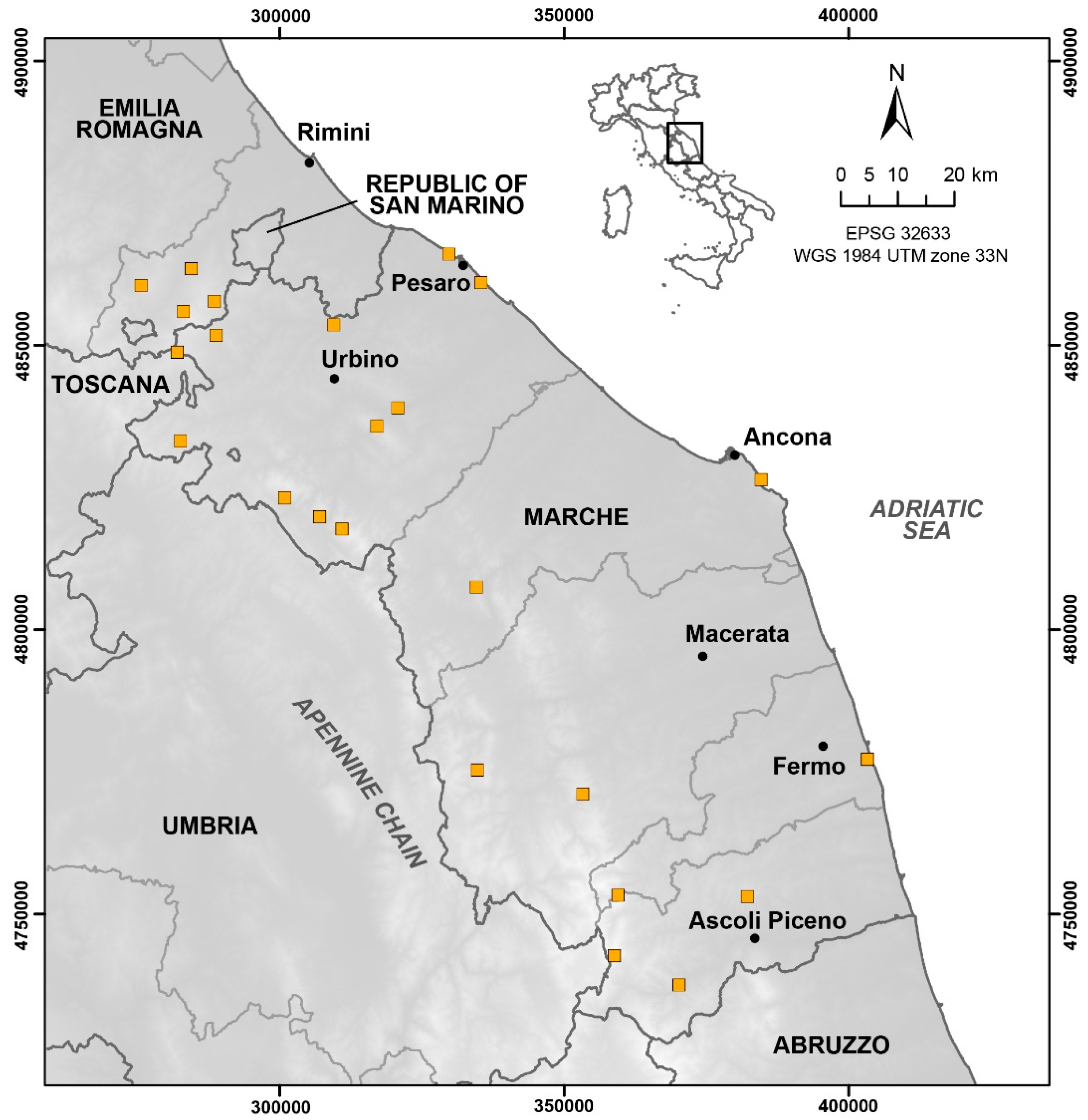
The Marche and southern Emilia-Romagna regions (central Italy) represent a restricted area between the Adriatic coast and the Apennine chain (
Figure 1), which boasts, in a limited space, a wide diversity of landforms: low sandy coasts, promontories overlooking the sea, rounded and greenish hills, fluvial terraces, spectacular gorges, rugged mountains dislocated by active fault systems, hot springs with thick travertine deposits, and tectonic thrusts. This variety is a consequence of the geological history of the Apennine chain [
28], which produced extraordinary contrasts of physical forms in a restricted space.
Moreover, located on the border between the Marche and Emilia-Romagna regions, the Valmarecchia and Montefeltro areas are well-known by geologists all over the world for the origin and evolution of the Valmarecchia nappe, which consists of stacked slices of Ligurian and Epiligurian rocks over-thrusting Tuscan and Umbro–Marchean units, and producing unique geological landscapes [
17,
30,
31]. Historians and artists also know these areas: they were sites of significant human settlements, in some cases since the prehistoric age, leaving us with testimonies of great cultural interest.
The altitude of this varied landscape (coasts, hills, and mountains, reaching a maximum height of 2476 m a.s.l. in about 9500 km
2) also produced a significant floristic and faunal heritage. These regions, moreover, still show intact areas where the landscape, culture, and traditions provide an excellent opportunity for didactic and touristic development [
15,
32,
33].
The territory is characterized by landforms whose formation is due to the complex interaction between endogenous (tectonic) and exogenous (erosive) processes, which, since the Neolithic period, were decisively overlaid by anthropogenic action of landscape shaping and transformation.
The map in
Figure 1 shows the study area and the location of the investigated geosites.
3. Communication Methods
Geosciences are traditionally conveyed during conferences or dedicated events as formal, one-way presentations. The official scientific research, as presented in international scientific conferences and journals, is indispensable, but this approach remains mainly addressed to academic or specialistic audiences.
Despite this, one of the main objectives of the scientific research, especially in topics where the interaction with human activities is strong, as in the case of geological and environmental issues, is to spread interest in important scientific themes, trying to reach people of all ages and social backgrounds. Simplifying scientific concepts, and making them attractive to the public, is essential to face challenges around the territory and the environment. In fact, geoscientists use too much specialized language, while non-geoscientists are not predisposed to understand issues that they consider to be the domain of specialists.
Some studies try to understand how geoscientists and non-geoscientists perceive geological concepts and activities, and their cognitive and affective responses. They conclude by remarking that geoscientists are increasingly required to incorporate emotions into communication efforts engaging with non-geoscientists [
34,
35].
In this view, it appears to be very useful for scientists to collaborate with artists, implementing new tools that can positively influence the emotional sphere, and capture people’s attention. During the last decades, there was great attention focused on the communication of even complex content to the general public in the scientific world, to raise awareness of important scientific and environmental topics [
11,
18,
34,
36,
37]. Art is an essential vehicle of content, involves people profoundly and directly, and has been used for a long time with significant impact.
This paper presents the experiences carried out by the research team in the last decade regarding different communication methods and different approaches to addressing the public (
Figure 2). Alongside the scientific approach, we propose a method to communicate using art forms, such as music, poetry, and theatrical improvisation techniques, to encourage people to learn more about landscapes by integrating their origins and physical aesthetics with their natural, cultural, and artistic heritage.
The former idea was to cross the different disciplines of Earth science, poetry, and music, applying them together to specific sites, and producing emotional experiences where encounters and interplay between the different languages became an expression of the place. Since the beginning of our project, our aim was to work on the emotional involvement of the audience, but in recent years we focused on collecting feedback data. From 2021 onwards, we asked the public who actively participated in the themed excursion events to fill in questionnaires for a more accurate analysis.
This experience started in 2014 with a team named
TerreRare, which means rare earth elements but also rare landscapes, composed of researchers and artists with different skills: two geologists, a writer/poet, a musician/musicologist, an actor, and a video-maker. Live events were initially proposed in central Italy and, parallel to these, the idea of the project was disseminated in national and international scientific conference [
38,
39,
40,
41].
In the meantime, a project dedicated to 20 geosites in the Marche Region (central Italy) was developed. The project results are included in a book in the native language [
15], with one DVD and two CD attached. Starting from the geological and morphological features of these 20 sites, the fundamental concepts of their genesis and evolution were identified. A simple scientific language, conceived for lovers of the territory from all cultural backgrounds, was used. An itinerary with some stops with significant site views was indicated for each location. The layout of the landscape is the result of complicated, unpredictable, and often disastrous events, and originates not only from geological processes, but also from the climate, and human intervention, underlying the delicate fragility of the environment. In a second step, the fundamental concepts previously identified were synthetized in a few key words translated into the poetic and musical languages, trying to activate emotional involvement and paths, ultimately stimulating a deeper understanding of the landscape. The poet suggests original poems, while the musician reproduces the site’s emotional impact by searching for a suitable piece of ancient music. Finally, for each site, some aspects of natural, historical, or cultural interest are suggested. Some videos, realized in these places, are contained in the enclosed DVD (the book is also available in an interactive form). The pieces of music, recorded for the project, can be found on the tied CDs [
16,
18]. A summary of the book’s contents is also presented on a website (
https://www.terreraremarche.it, accessed on 28 February 2022). The 20 geosites can be visited virtually, and the geological history of these places, the information on the morphologic features, and the cultural aspects around these places can be explored. The poems and the pieces of music are also the soundtracks of videos that, by using the best views of these places, creatively interpret science and nature through art.
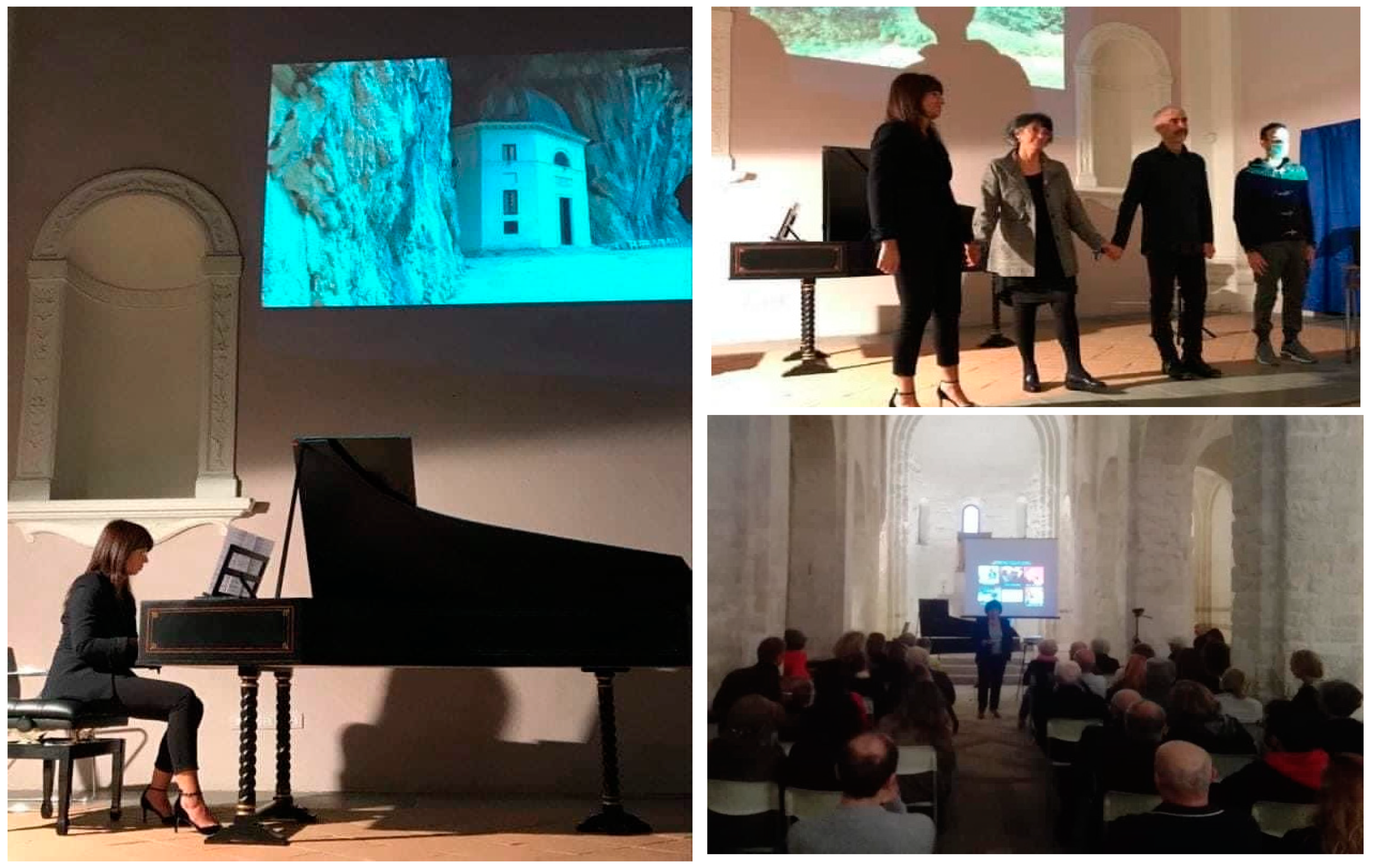
The project was presented several times in popular events, always arousing participation and interest, but this work’s most effective communicative method is through live events. Since the beginning of this project, the public were addressed directly through shows that combine scientific communication in popular language with the reading of poems, and the live performance of music. A total of ten live performances were organized, sometimes near one of the proposed geosites, sometimes outside the region, with the aim of promoting the richness of the Marche region. The shows are usually dedicated to five or six places and their main geological and geomorphological aspects. The speaker uses conversational language, focusing on the most interesting aspect of the genesis, and how the morphology influenced the history and culture of the site. Finally, the speaker guides the public, and identifies keywords that represent the link between science, music, and poetry. The musical and poetic performances are conducted in front of a large screen with projections of images and videos of the places (
Figure 3). The result is the total emotional participation of the public in the places.
Communication to the public through social media was not overlooked: the widespread interest in this project is testified by a total of about 30,000 views (see the number of views for each video at
https://www.facebook.com/search/videos/?q=terrerare, accessed on 28 February 2022), and 950 followers of the Facebook page.
From 2020, the project Paesaggeo (from contraction of the Italian words paesaggio and geologico, i.e., geological landscape) was founded, for experimenting with online and live actions concerning the emotional involvement of the public. To sum up, the aim was to investigate the involvement of users with conventional and newly proposed means, such as music, poetry, and field experiences. Paesaggeo’s trekking proposal was realized during the summer of 2021, including four different approaches to disseminating geoheritage values (i.e., classic guided tours, exploring experiences, direct interaction with the public with narrative and theatrical improvisation, and the emotional engagement of users through music and art). Paesaggeo’s experiences were carried out as part of a doctoral research at the University of Urbino, which selected the Valmarecchia and Montefeltro areas as test locations to experiment with different communicative methods, engaging directly with the public. This method involved participants from several perspectives, interacting with their scientific curiosity, and inspiring a sense of wonder and joy or other emotions.
An online survey was also created within the project. It aimed to better understand the existing relationship between geological landscapes and human emotions, or the perception of geological landscapes. The survey was conceived with the help of a psychologist—an expert in ecopsychology—to collect people’s emotive responses regarding photographs of different geological landscapes. The answer can be selected from the following multiple options:
- a.
Desire, hope (joy/serenity/interest)—positive activation of the user;
- b.
Enthusiasm, optimism (love/gratitude/freedom/passion)—positive activation of the user;
- c.
Boredom (indifference/detachment)—deactivation of the user;
- d.
Nostalgia (melancholy/resignation/disappointment)—deactivation of the user;
- e.
Worry, concern (anxiety/sadness/frustration/overwhelm)—negative activation of the user;
- f.
Pain, anger (discomfort/fear/helplessness)—negative activation of the user.
For each photograph, another question was asked: “Would you like to see it live?” After viewing 14 geological landscapes, some general information was asked to obtain basic knowledge about people responding (age, origin). The first means of popularization of the online survey was the creation of an Instagram profile (@paesaggeo
https://www.instagram.com/paesaggeo/, accessed on 28 February 2022), with the intent to illustrate and promote the geological landscape of the Valmarecchia and Montefeltro areas. A unique graphic design was conceived to give the project identity, thus, making it recognizable and facilitating its positioning in users’ minds. The profile was also used, among others, to promote live events performed throughout the summer of 2021, as experiences of enhancement of the geological landscape directly in the field. During these events, the effectiveness of this communicative method through different kinds of experiences is proven. There are, in fact, several types of users who like to get involved in guided tours in nature; a total of 85 trekkers were engaged to promote four different kinds of geologically themed treks that could stimulate the emotional field of participants differently. People were brought to have a first-hand experience of the geological heritage thanks to the support of the “Sasso Simone and Simoncello Park”, who promoted 16 appointments as part of his hiking calendar.
The titles and contents of the four kinds of appointments are listed as follows:
- ⁻
Let’s explore a Geolandscape. The environmental guide brought the users out of the main trails to find geological treasures (such as minerals in badland areas) and hidden processes in the wildest areas. Users are invited to explore, research, and touch by hand the geological heritage, with an approach that encourages curiosity and drives them to experiment their limits.
- ⁻
A story in the Geolandscape, in which gamification dynamics characterize the experience. This modality is a sort of time travel, through which the users live a story in the first person, set in climatic and historical-cultural contexts of the past, surrounded by realistic characters. Participants are called upon to interact with the story, and the characters involve the audience with theatrical improvisation techniques. This experience was realized in collaboration with the informal group Malafeltro, which deals with the unconventional valorization of territories through games and interacting with the public. Each site was narrated through a verisimilar story, based upon historic knowledge, about the interaction between the geological landscape and human settlements.
- ⁻
Let’s listen to the Geolandscape, in which the geological heritage is expressed through the languages of music and poetry. The poems were chosen from famous or, when possible, local authors, and prose testimonies or chronicles related to the geological events involved in the excursion were also read. The musical pieces were expressly composed by a local musician, a young guitarist who was previously brought to the selected sites and made aware of their geological features and specific content to translate into music. He then composed and performed the pieces live, halfway through the hike.
- ⁻
Trekking in a Geolandscape is a classic excursion in nature trails, accompanied by an environmental guide, which explains in a traditional way the salient geological features of the various landscapes, accompanied by explanations and examples. This was conceived to be the least emotionally engaging experience, or a “control” modality, to compare the other three kinds of excursion. This expectation is proven wrong, as is further discussed.
At the end of the treks, people were asked to answer a survey about their feelings during the experience. The collection of these additional surveys allowed us the chance to compare how the four different kinds of experiences engaged with the emotional field of the participants.
The promotion of the live events was performed via social media (@paesaggeo and @parcosassosimonesimoncello Instagram accounts, and Parco Sasso Simone e Simoncello Facebook page, which counts more than 9000 followers), and through the official website and newsletter of the Natural Park (counting more than 4000 subscribers). The events were also promoted with monthly paper flyers distributed in the local provinces (Rimini and Pesaro-Urbino).
4. Discussion
This work deals with multidisciplinary and interactive approaches to promote the communication of rigorous and complex scientific content related to geoheritage, combining traditional scientific communication with other languages, such as poetry, music, and theatrical improvisations, throughout popular publications, announcements through social media, conferences, live performances, and across different modes of guided experiences in field excursions.
Communication that addresses the emotional sphere is recognized as being much more effective than traditional communication methods, since it can engage the observer in a profound and passionate way. This experience with the emotional involvement of the public in geoheritage promotion produces encouraging results. A story about the origins of a landscape and its fragility through different forms of art often results in an intimate relationship between the public and the place.
We followed this route by proposing the 20 geosites included in the book previously described [
15], as well as in the attached DVD, where music, poems, and videos are combined to illustrate a place. The content of the book, summarized in a website, was reached by visitors who sometimes contacted us to visit these places or for more information about the sites.
The live performances attracted a wide and varied audience, mostly without a scientific background, and highlight the great interest of the people in the geological heritage, and its relationships with the environment, human activities, and culture. These performances are arranged following the multidisciplinary communication method described above, combining science, projections of images and videos, readings of poems, and live musical executions (
Figure 3).
The response from the public (audience feedback) is always high, although not easy to quantify, as the early stages of this research do not include the collection of quantitative data on the kind of audience and the relative perception achieved.
Paesaggeo was then conceived, with great attention paid to collecting information on the effectiveness of the method. As a first step, we tried to identify the emotional activations of the public in relation to the geological process, through a digital survey. This online survey about geological landscape perception was promoted through Instagram only, from April to December 2021, an activity that led to only 31 answers. Most of the answers we collected were instead obtained after sending the poll personally to all people who took part in the summer excursions, and to friends and colleagues, until reaching a total of 165 responses.
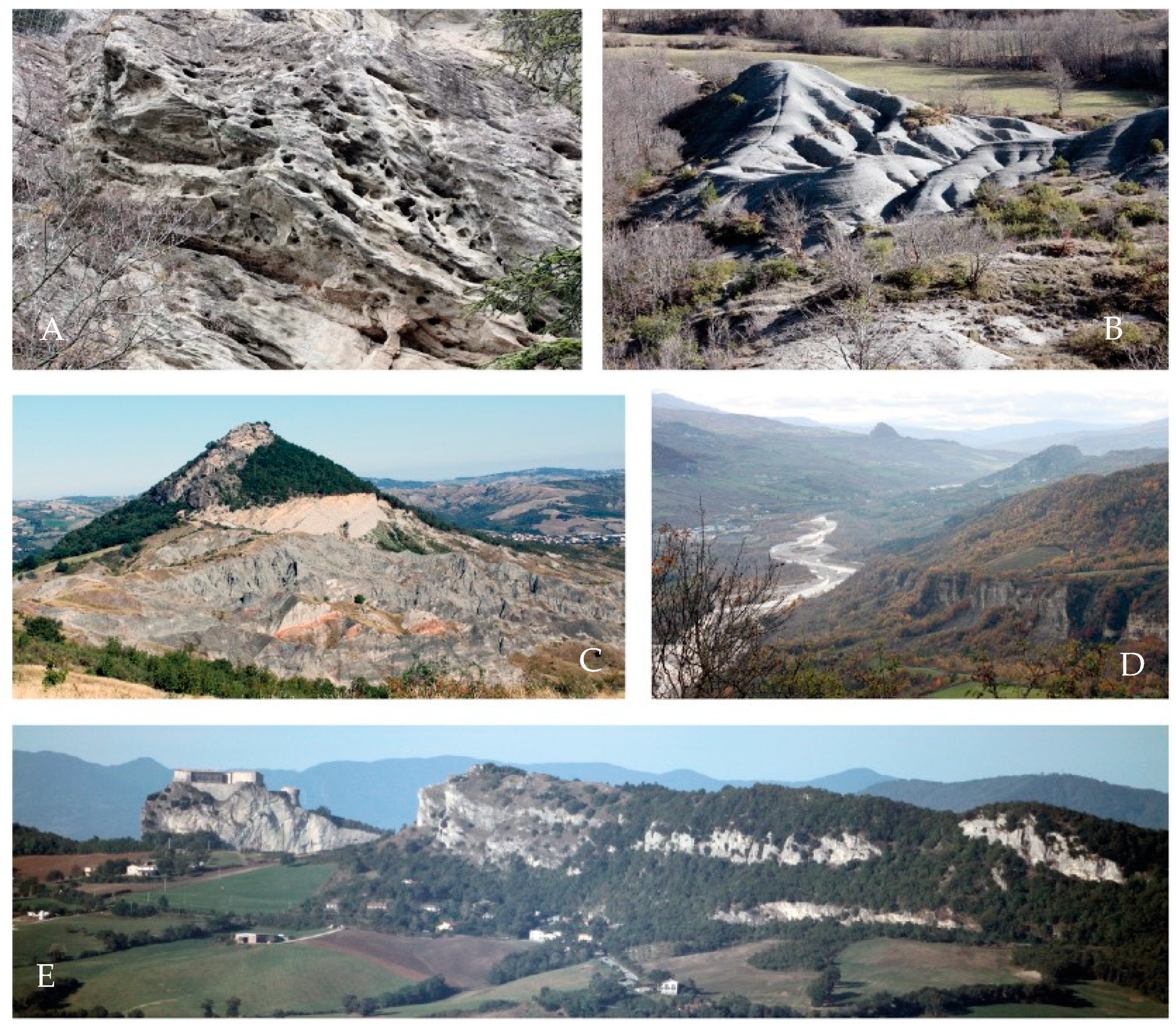
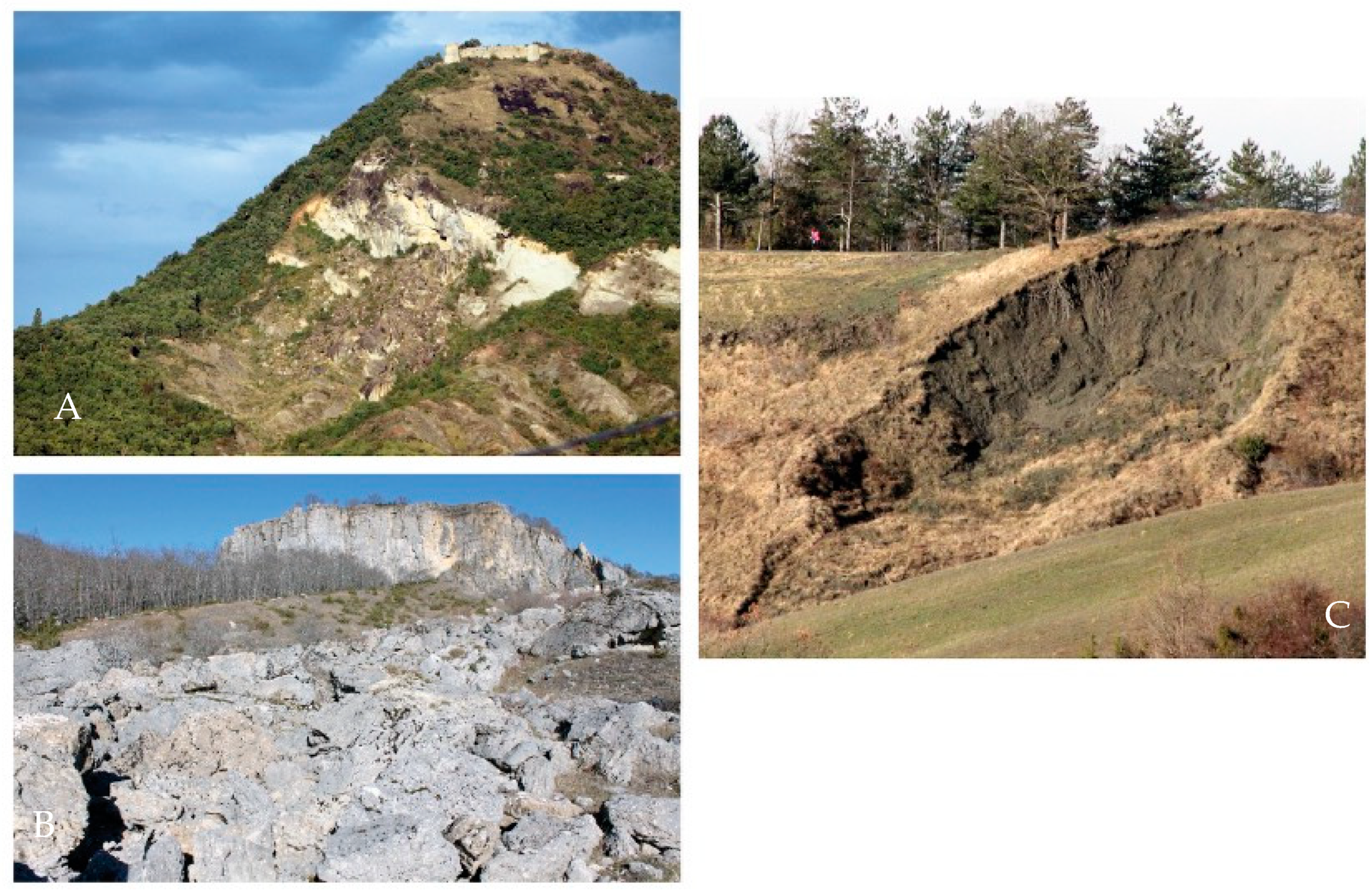
The results of the survey have been compared by summarizing them in four image groups, listed as follows:
- 1.
Warm-colored geological landscapes: Casteldelci cliff; Colorìo marls; Sasso Simone cliff; Tausano rock-fall; Mt. Pincio, and Aquilone (
Figure 4);
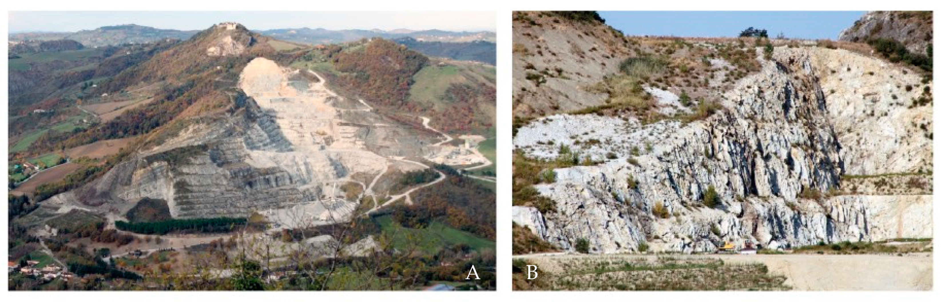
- 2.
Cold-colored geological landscapes: honeycomb erosion of Mt. Perticara; San Leo and the Tausani cliff; Maiolo cliff and badlands; Costa dello Speco and Marecchia River; Pratieghi marls (
Figure 5);
- 3.
Landslides: small landslide with a tree; active rock-fall of Maiolo; moving boulders of Sasso Simone (
Figure 6);
- 4.
Quarry sites: San Giovanni in Galilea quarry; Mt. Ceti quarry (
Figure 7).
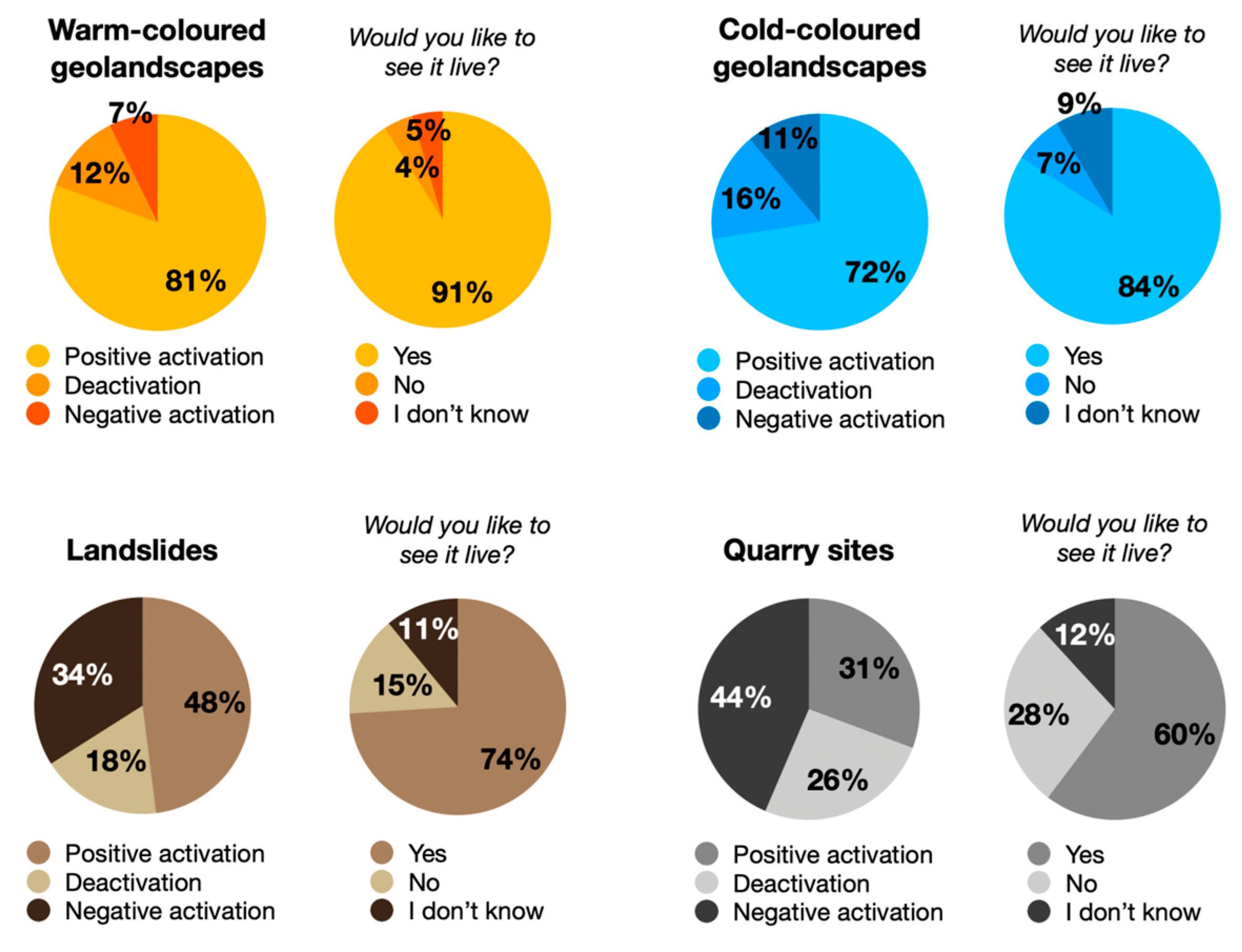
The last two groups (landslides and quarry sites) were the first to be established, as they represent very focused portraits of two different, but impressive, phenomena. The other images represent wider areas, or other types of processes (i.e., a river meander, honeycomb erosion, cliffs), and they are divided into two groups by estimating the chromatic characters of the images.
The results are presented here in a merged mode, obtained by summing and putting into percentage the results obtained for each group, and graphically shown in
Figure 8:
- 1.
Warm-colored geological landscapes produce the highest positive activations in users, with 80.61%. Deactivation reaches 12.12%, while negative activation is equal to 7.27%. A total of 91.06% of the users would like to see those kinds of geological landscapes, 4.39% of users declare they do not want to, and 4.55% say they do not know.
- 2.
Cold-colored geological landscapes have a slightly lower percentage of positive activations, with 72.49%. Deactivation increases to 16.36%, and negative activation is perceived by 11.15% of the compilers. A total of 84.12% of the users would like to see these geological landscapes live, 7.27% would not, and 8.61% do not know.
- 3.
The images picturing landslides obtain a total of 47.68% of positive activations in users, 18.38% cases of deactivations, and 33.94% of negative activation. Nevertheless, 74.34% of compilers declared that they would like to see that geological landscape live, 15.15% do not want to, while 10.51% do not know.
- 4.
Quarry sites are the most negatively perceived geological landforms in the survey. They receive 43.64% for negative activations, 25.76% for deactivations, and just 30.6% for positive activations. Overall, 60.3% of users would, however, like to see them live, 27.88% said they do not, and 11.82% said they do not know.
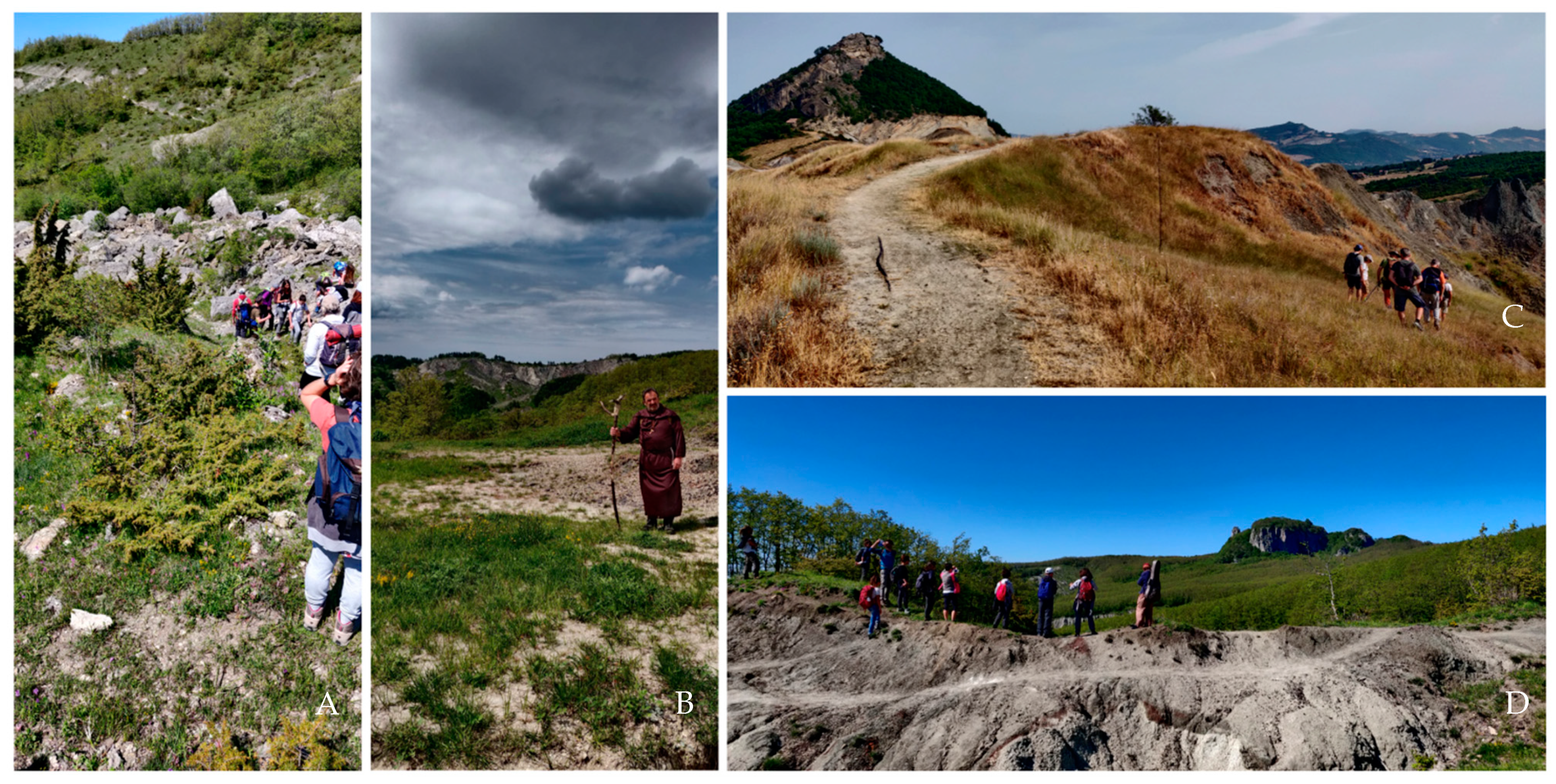
As our daily lives are littered with pervasive, and sometimes invasive, technologies, the importance of experiencing nature first-hand seems more relevant than ever. It is expressed as a renewed interest on the part of people to live in closer contact with the natural environment. Therefore, it was decided to experiment with disseminating geomorphological heritage concepts through a series of dedicated events. They took place on four weekends from May to August 2021, at Sasso Simone and Simoncello, Mt. Ercole and Mt. San Silvestro, Maiolo cliff and badlands, and Maciano hill and Scavolino palaeo-lake geomorphosites, located in the Valmarecchia and Montefeltro areas.
On Saturdays,
Let’s explore a Geolandscape was proposed in the mornings and early afternoons, while
A story in the Geolandscape mode took place in the later afternoon and evening. On Sundays, the mornings and early afternoons were dedicated to
Trekking in a Geolandscape, and the later afternoons and evenings to
Let’s listen to the Geolandscape (
Figure 9). Mealtimes were included in all the excursions, to allow the group a moment of sharing, both within the group, and with the guide and the other accompanying persons.
At the beginning of each experience, the participants were given a general context of the research, including definitions of geosites, geomorphosites, and geological heritage. They were also asked about the possibility of sending an evaluation survey concerning the emotional involvement experienced during the excursion, and some other contents of the research. The questionnaires (in native language) are available at the following links: Sasso Simone and Simoncello
https://forms.gle/mgKjzm157REKUyK99; Mt. Ercole and Mt. San Silvestro
https://forms.gle/PJDLx2FrYSXX6cGDA; Maiolo cliff and badlands
https://forms.gle/Usoe6v8MF4MwuGa16; Maciano hill and Scavolino palaeo-lake
https://forms.gle/oP6vycoHN1ExzWB46 (links accessed on 20 June 2022).
The surveys’ outcomes show how the public that engage in such experiences agree on the efficacy of emotional engagement as helpful in remembering geological content. The first four questions aim to obtain the user’s general opinion about geosites, and how hiking experiences enhance them. The answers make clear how positive the perception of geological heritage and geologically themed treks is in the groups, and how this kind of experience triggers a curiosity to make similar ones in the future: 100% of the participants think it is important to enhance sites of geological interest through geologically themed excursions; 98.82% believe that the selected geosites should be enhanced through such experiences; 50.59% of the users had never participated in geologically themed tours, led by a hiking guide specialized in geology; and 100% of participants think they will take part in other geological excursions in the future.
From the polls, it follows that 16.47% of participants (14 out of 85) choose the Trekking in a Geolandscape mode, and the same percentage choose the Let’s explore a Geolandscape mode. On the other hand, A story in the Geolandscape and Let’s listen to the Geolandscape appointments reach 34.12% (29) and 32.94% (28 out of 85) of the total participants, respectively, showing how a highly interdisciplinary approach interests more people. All the participants (100%) feel that the trek mode they selected effectively conveys the geological content of that place.
Figure 10 shows how, on a scale from 1 to 5, most of the users feel highly emotionally involved, and how the scores are distributed among the different modes of excursions. Differences are not detectable, as an emotional engagement is probably conveyed simply by spectacular geological landscapes, or the excitement of living experiences in nature, in groups, or in the first person.
Almost all the participants think that enhancing the territory, including emotional engagement, could effectively transmit geological content (98.82%), and the same percentage would be curious to try the other excursion modes (84 out of 85 users).
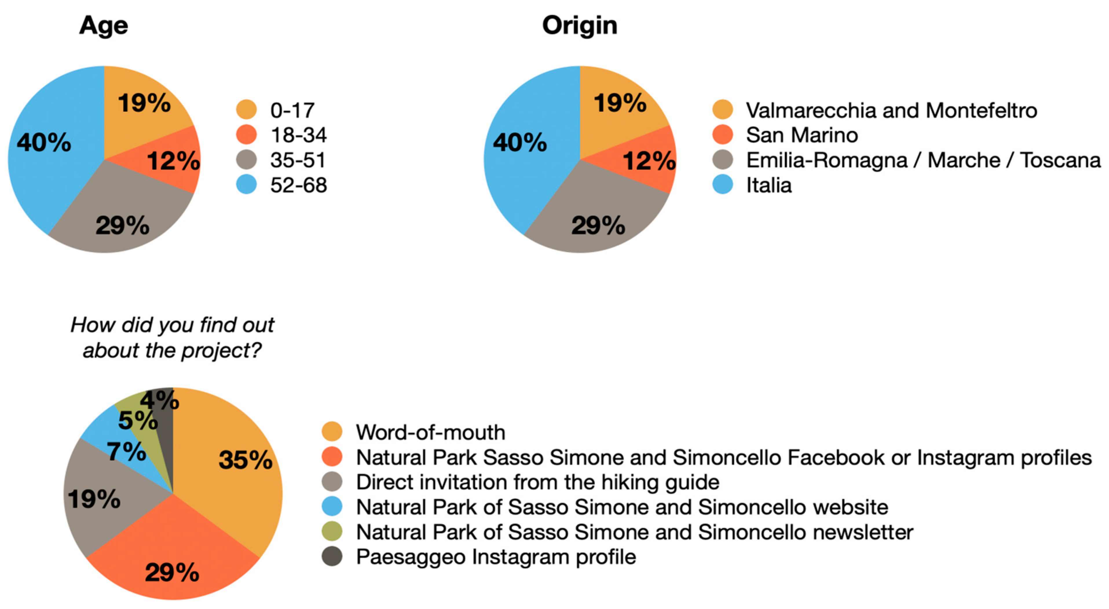
Finally, some general information is asked to know more about the public age and origin, and how they came to know about the excursions. The results, summarized in
Figure 11, show the involvement of different age groups, coming mostly from the Valmarecchia and Montefeltro areas, San Marino, or the surrounding Emilia-Romagna, Marche, and Toscana regions, thus, expressing the involvement mainly of locals and inhabitants, and not tourists. Also, we learned how most of the public came to know about the project: mostly through word-of-mouth, Facebook, the Instagram accounts of Parco Sasso Simone and Simoncello, or a personal invitation by the hiking guide. Lastly, an open question was asked to the users, regarding comments or suggestions: many answers show sincere appreciation, and the hope that similar events could be proposed in the future, also underlying how “the dissemination of scientific content through art is an effective strategy that should be strengthened”.
In this paper, it was possible to experiment with the active engagement of the participants both during the excursions of the geotourism proposal Paesaggeo, which involved a total of 85 trekkers in the summer of 2021, and thanks to the 165 people who completed the online survey.
Four pictures in the online poll portrayed two geomorphosites enhanced by the live experiences (i.e., Sasso Simone and Simoncello, and Maiolo cliff and badlands), thus, making it possible to show how the same geological landscape can be perceived differently if we compare its digital and live views. In fact, in all the case studies, a live view produces positive feelings different from the digital image, as shown by the following results:
- ⁻
Maiolo badlands—positive activation from 62.43% (digital) to 94.44% (live); deactivation from 16.36% (digital) to 5.56% (live); negative activation from 21.21% (digital) to 0% (live);
- ⁻
Southern cliff of Sasso Simone and Simoncello—positive activation from 79.39% (digital) to 91.67% (live); deactivation from 7.88% (digital) to 4.16% (live); negative activation from 12.73% (digital) to 4.16% (live);
- ⁻
Active rock-fall of Maiolo cliff—positive activation from 69.09% (digital) to 88.88% (live); negative activation from 20.61% (digital) to 5.56% (live); deactivation from 10.3% (digital) to 5.56% (live);
- ⁻
Boulders of Sasso Simone—positive activation from 56.36% (digital) to 87.5% (live); deactivation from 26.06% (digital) to 12.5% (live); negative activation 17.58% (digital) to 0% (live).
Therefore, it is assumed that a live view of geological heritage results in a general, more positive perception from non-experts, which can increase if the portrayed phenomena are accompanied by explanations of hiking guides, and positive emotional involvement.
5. Conclusions
In the last decade, our experiences with geoheritage communication led us to approach the public in a progressively more conscious way. In this paper, we focus the attention and research activity on improving the scientific communication strategy in a geotourist context. The tools used to make scientific concepts related to the Earth sciences more accessible show that communication through classical scientific language should only be used with an expert audience; otherwise, it is difficult to achieve a proper involvement and understanding of the topics. So, simple and popular language is suitable for events reserved for a heterogeneous and non-expert audience. In particular, in this research, different communication methods, such as publications, announcements through social media, conferences, live performances, and field excursions appealing to the emotional involvement of the public, were adopted. The monitoring of the public emotive answer and agreement was carried out by a questionnaire onsite, and an online survey on Instagram.
The performances with poetry reading and live music (ten live events were organized, sometimes held near the proposed geosites, sometimes in places outside the region) show how the introduction of language linked to art can deeply capture the attention of the public, making even complex scientific content more accessible to a non-expert audience. The live music performances, for example, involved a large and varied audience, sensitive to nature and art, and eager to learn about geology, landscapes, and their relations with human activities.
The immersion in the sites directly in the field (sixteen thematic excursions were organized in some of the case studies) highlight how the perception of a place is much more positive if the experience is lived in the first person, directly on the site. The feedback obtained from the participants in the excursions confirms, once again, the importance of using a multidisciplinary method linked to games, music, acting, reading stories related to the place, and improvised theatrical activity, in the mode of communication.
The emotional involvement of the users highlights the effectiveness of the method, which was used to convey not only the pure geological content, but also the cultural and traditional content, and the possibilities of protection and conservation of the sites.
Comparing these experiences with conventional communication methods, and the communication method used here, developed by integrating it with art forms, it is worth noting that people show a stronger interest in the second case, contacting the organizers after live events to ask for details about the projects, or more information about the geosites or how to visit them. This behavior is reflected in increased interest and appreciation in our social media, especially after the live events.
Experiences with the active engagement of participants during geotourism excursions show how the same geological landscape can be perceived differently when comparing its digital and live views. A live view of the geological heritage results in a more positive overall perception by non-experts, which increases if the phenomena portrayed is accompanied by explanations from hiking guides and positive emotional involvement.
By experimenting with different methods of communication, a wide audience is reached, without distinction in social origin, age, or cultural background, finally achieving the main goal of this project, which is to contribute to the enhancement of our great geological and geomorphological heritage.


