
Patterns and Abundance of Rare Earth Elements in Sediments of a Bedrock River (Miño River, NW Iberian Peninsula)


Abstract
:1. Introduction
2. Study Area
3. Materials and Methods
4. Results and Discussion
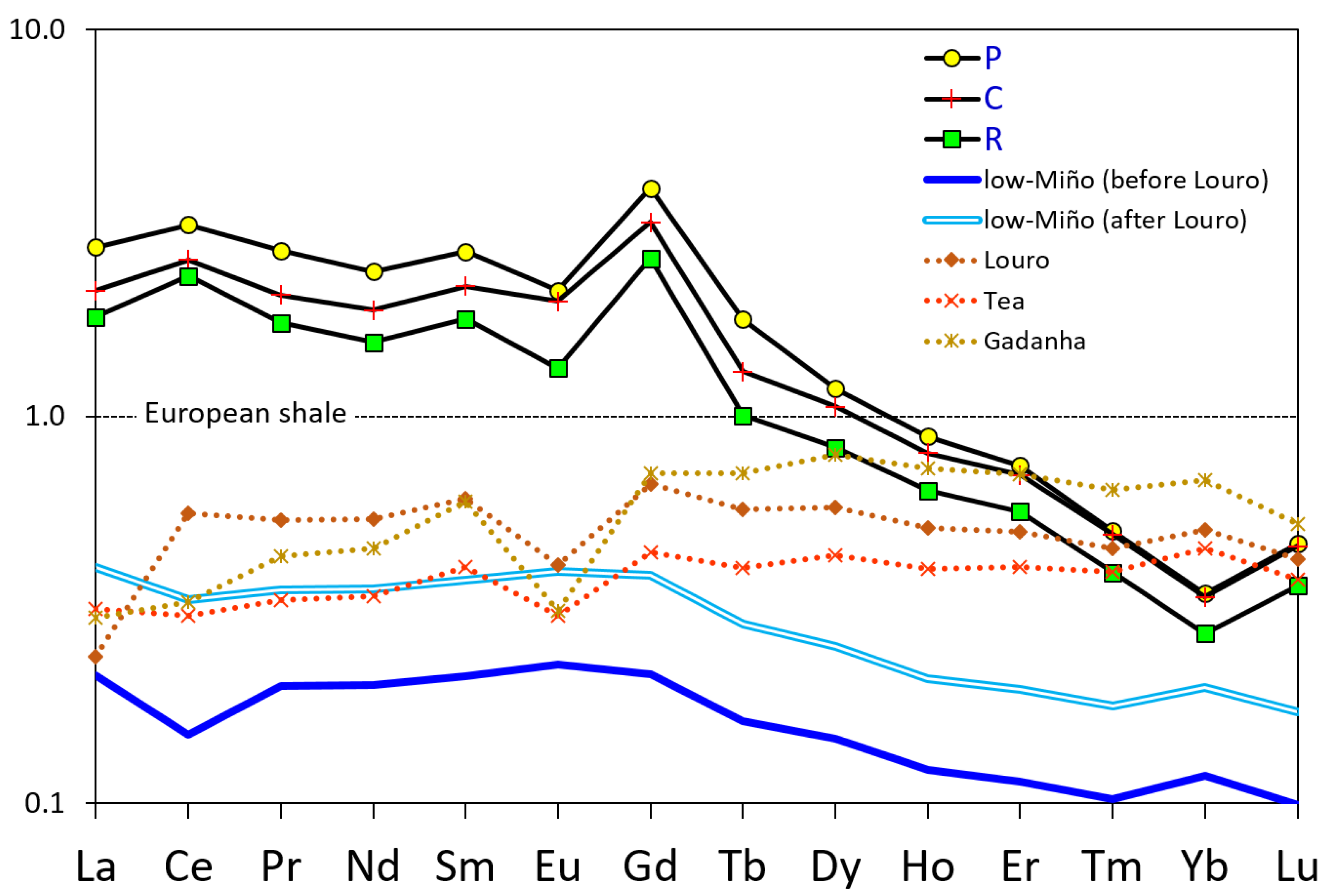
4.1. Ln-REE Abundance
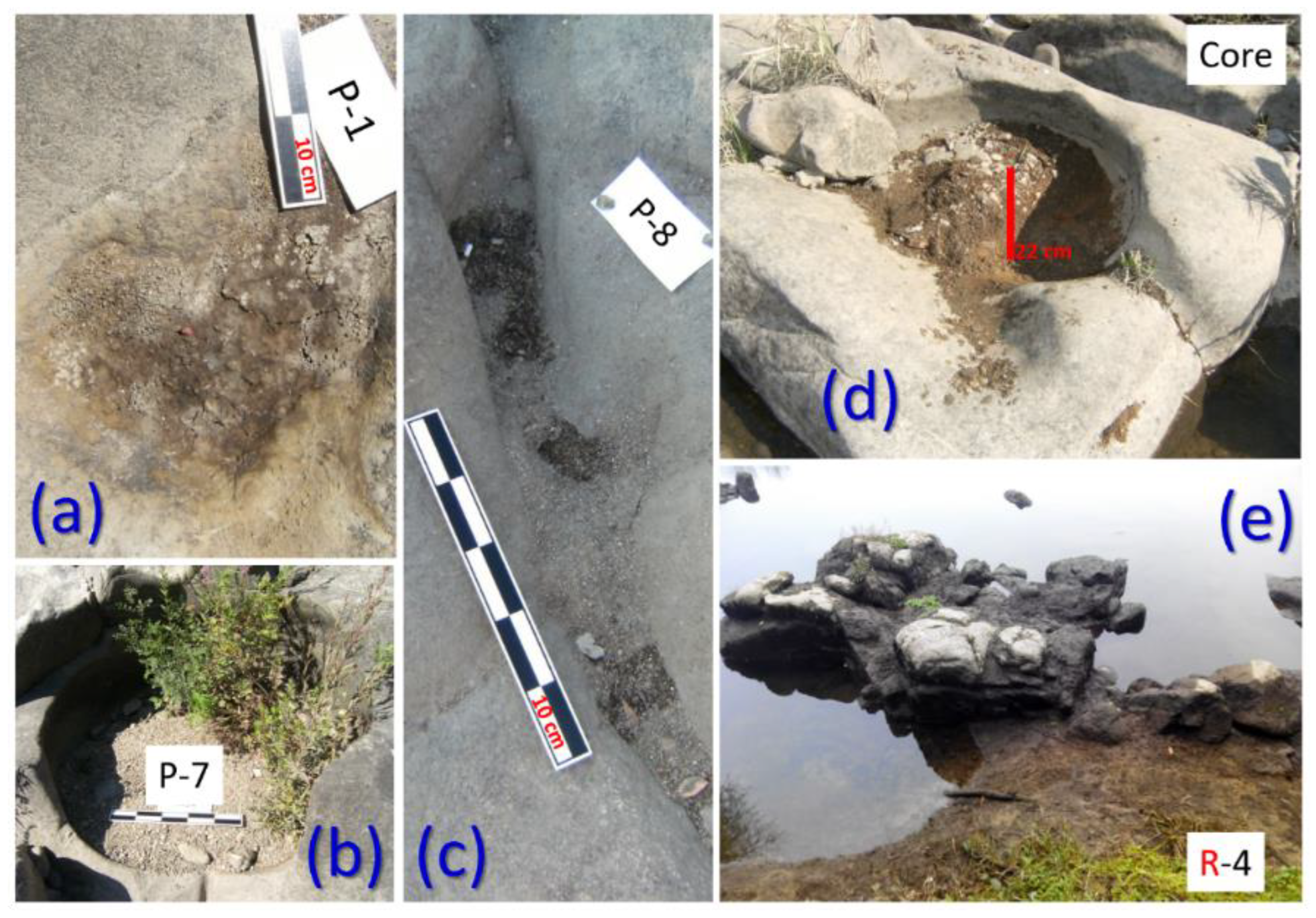
4.2. Depositional Microenvironments
- P > C > R (Nd, Sm, Gd, Dy, and Ho)
- P ≈ C > R (Y, Eu, Er, Tm, Yb, and Lu)
- P > C ≈ R (La, Ce, Pr, and Tb)
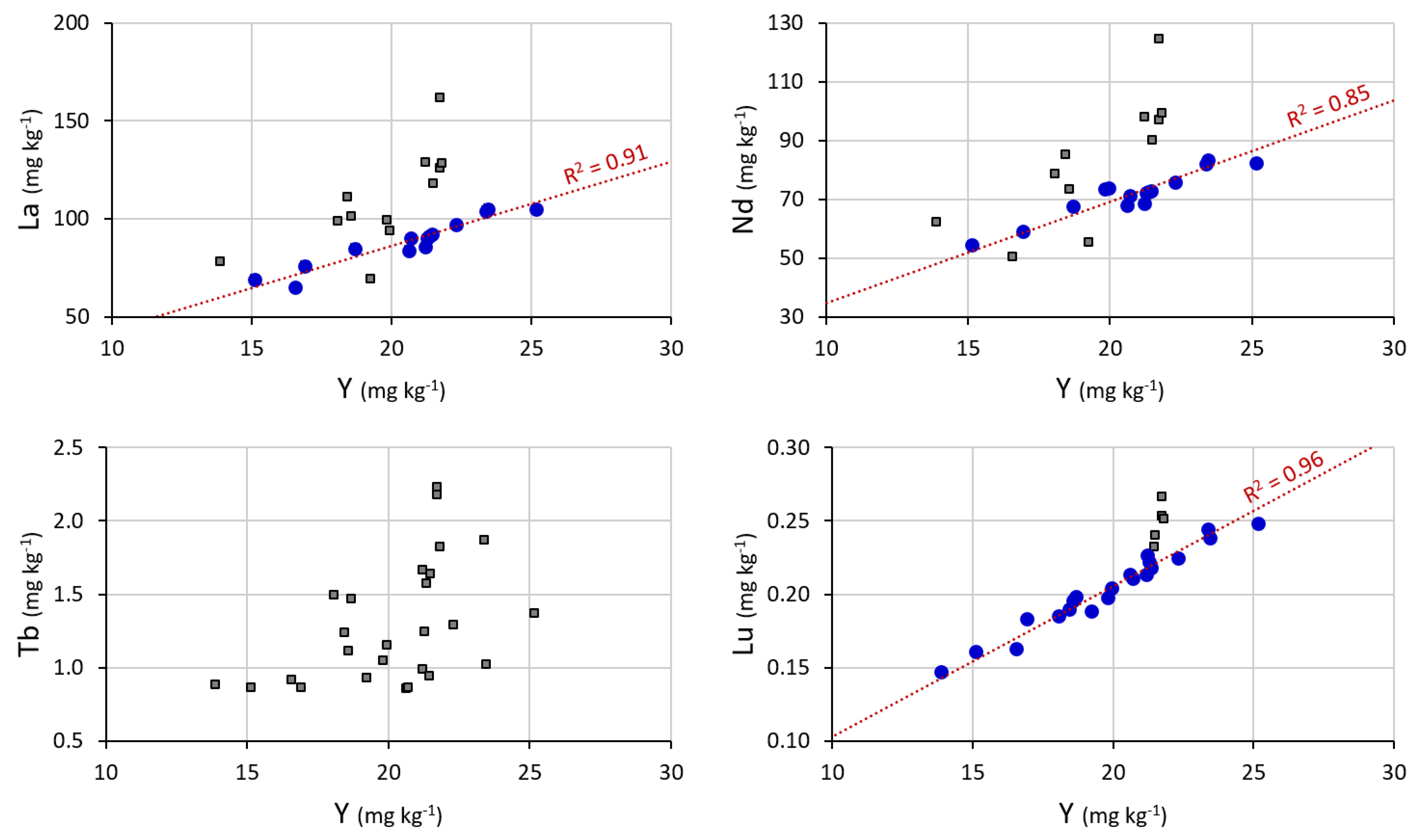
4.3. Background Estimation and Environmental Assessment
5. Conclusions
Author Contributions
Funding
Institutional Review Board Statement
Informed Consent Statement
Conflicts of Interest
References
- Balaram, V. Rare earth elements: A review of applications, occurrence, exploration, analysis, recycling, and environmental impact. Geosci. Front. 2019, 10, 1285–1303. [Google Scholar] [CrossRef]
- Cobelo-García, A.; Filella, M.; Croot, P.; Frazzoli, C.; Du Laing, G.; Ospina-Alvarez, N.; Rauch, S.; Salaun, P.; Zimmermann, S. COST action TD1407: Network on technology-critical elements (NOTICE)—from environmental processes to human health threats. Environ. Sci. Pollut. Res. 2015, 22, 15188–15194. [Google Scholar] [CrossRef] [PubMed] [Green Version]
- Migaszewski, Z.M.; Gałuszka, A. The characteristics, occurrence, and geochemical behavior of rare earth elements in the environment: A review. Crit. Rev. Environ. Sci. Technol. 2015, 45, 429–471. [Google Scholar] [CrossRef]
- Gu, Y.G.; Gao, Y.P.; Huang, H.H.; Wu, F.X. First attempt to assess ecotoxicological risk of fifteen rare earth elements and their mixtures in sediments with diffusive gradients in thin films. Water Res. 2020, 185, 116254. [Google Scholar] [CrossRef] [PubMed]
- Rim, K.T. Effects of rare earth elements on the environment and human health: A literature review. Toxicol. Environ. Health Sci. 2016, 8, 189–200. [Google Scholar] [CrossRef]
- Liu, W.S.; Guo, M.N.; Liu, C.; Yuan, M.; Chen, X.T.; Huot, H.; Zhao, C.M.; Tang, Y.T.; Morel, J.L.; Qiu, R.L. Water, sediment and agricultural soil contamination from an ion-adsorption rare earth mining area. Chemosphere 2019, 216, 75–83. [Google Scholar] [CrossRef] [PubMed]
- Romero-Freire, A.; Minguez, L.; Pelletier, M.; Cayer, A.; Caillet, C.; Devin, S.; Gross, E.M.; Guérold, F.; Pain-Devin, S.; Vignati, D.A.L.; et al. Assessment of baseline ecotoxicity of sediments from a prospective mining area enriched in light rare earth elements. Sci. Total Environ. 2018, 612, 831–839. [Google Scholar] [CrossRef]
- Sanders, L.M.; Luiz-Silva, W.; Machado, W.; Sanders, C.J.; Marotta, H.; Enrich-Prast, A.; Bosco-Santos, A.; Boden, A.; Silva-Filho, E.V.; Patchineelam, S.R. Rare earth element and radionuclide distribution in surface sediments along an estuarine system affected by fertilizer industry contamination. Water Air Soil Pollut. 2013, 224, 1742. [Google Scholar] [CrossRef]
- Costa, L.; Mirlean, N.; Johannesson, K.H. Rare earth elements as tracers of sediment contamination by fertilizer industries in Southern Brazil, Patos Lagoon Estuary. Appl. Geochem. 2021, 129, 104965. [Google Scholar] [CrossRef]
- Prego, R.; Caetano, M.; Bernárdez, P.; Brito, P.; Ospina-Alvarez, N.; Vale, C. Rare earth elements in coastal sediments of the northern Galician shelf: Influence of geological features. Cont. Shelf Res. 2012, 35, 75–85. [Google Scholar] [CrossRef] [Green Version]
- Dung, T.T.T.; Cappuyns, V.; Swennen, R.; Phung, N.K. From geochemical background determination to pollution assessment of heavy metals in sediments and soils. Rev. Environ. Sci. Bio/Technol. 2013, 12, 335–353. [Google Scholar] [CrossRef]
- Birch, G.F. Determination of sediment metal background concentrations and enrichment in marine environments–a critical review. Sci. Total Environ. 2017, 580, 813–831. [Google Scholar] [CrossRef] [PubMed]
- Tůmová, Š.; Hrubešová, D.; Vorm, P.; Hošek, M.; Grygar, T.M. Common flaws in the analysis of river sediments polluted by risk elements and how to avoid them: Case study in the Ploučnice River system, Czech Republic. J. Soils Sediments 2019, 19, 2020–2033. [Google Scholar] [CrossRef]
- Álvarez-Vázquez, M.Á.; González-Prieto, S.J.; Prego, R. Possible impact of environmental policies in the recovery of a Ramsar wetland from trace metal contamination. Sci. Total Environ. 2018, 637, 803–812. [Google Scholar] [CrossRef] [PubMed]
- Meybeck, M.; Friedrich, G.; Thomas, R.; Chapman, D. Rivers. In Water Quality Assessments—A Guide to Use of Biota, Sediments and Water in Environmental Monitoring, 2nd ed.; Chapman, D., Ed.; UNESCO/WHO/UNEP: Nairobi, Kenya, 1992; pp. 239–316. [Google Scholar]
- Chakrapani, G.J. Factors controlling variations in river sediment loads. Curr. Sci. India 2005, 88, 569–575. [Google Scholar]
- Whipple, K.X.; Dibiase, R.A.; Crosby, B.T. Bedrock rivers. In Fluvial Geomorphology; Elsevier Inc.: Amsterdam, The Netherlands, 2013; pp. 550–573. [Google Scholar]
- Miller, J.R.; Watkins, X.; O’Shea, T.; Atterholt, C. Controls on the Spatial Distribution of Trace Metal Concentrations along the Bedrock-Dominated South Fork New River, North Carolina. Geosciences 2021, 11, 519. [Google Scholar] [CrossRef]
- Álvarez-Vázquez, M.A.; De Uña-Álvarez, E. Growth of sculpted forms in bedrock channels (Miño River, northwest Spain). Curr. Sci. India 2017, 112, 996–1002. [Google Scholar] [CrossRef]
- Álvarez-Vázquez, M.A.; De Uña-Álvarez, E. Inventory and assessment of fluvial potholes to promote geoheritage sustaina-bility (Miño River, NW Spain). Geoheritage 2017, 9, 549–560. [Google Scholar] [CrossRef]
- Álvarez-Vázquez, M.Á.; De Uña-Álvarez, E. An exploratory study to test sediments trapped by potholes in Bedrock Rivers as environmental indicators (NW Iberian Massif). Cuatern. Geomorfol. 2021, 35, 59–77. [Google Scholar] [CrossRef]
- Richardson, K.; Carling, P.A. A Typology of Sculpted Forms in Open Bedrock Channels; Geological Society of America: Boulder, CO, USA, 2005; Special Paper 392; 108p. [Google Scholar]
- Barrera Morate, J.L.; González Lodeiro, F.; Marquínez García, J.; Martín Parra, L.M.; Martínez Catalán, J.R.; Pablo Maciá, J.G. Memoria del Mapa Geológico de España, Escala 1:200.000, Ourense/Verín; Instituto Tecnológico GeoMinero de España: Madrid, Spain, 1989; 284p. [Google Scholar]
- Álvarez-Vázquez, M.A.; De Uña-Álvarez, E.; Prego, R. Background of U and Th in sediments of bedrock rivers. Environ. Smoke 2021, 17–23. [Google Scholar] [CrossRef]
- Grygar, T.M.; Popelka, J. Revisiting geochemical methods of distinguishing natural concentrations and pollution by risk elements in fluvial sediments. J. Geochem. Explor. 2016, 170, 39–57. [Google Scholar] [CrossRef]
- Franklin, R.; Ferreira, F.; Bevilacqua, J.; Fávaro, D. Assessment of metals and trace elements in sediments from Rio Grande Reservoir, Brazil, by neutron activation analysis. J. Radioanal. Nucl. Chem. 2012, 291, 147–153. [Google Scholar] [CrossRef]
- Boës, X.; Rydberg, J.; Martinez-Cortizas, A.; Bindler, R.; Renberg, I. Evaluation of conservative lithogenic elements (Ti, Zr, Al, and Rb) to study anthropogenic element enrichments in lake sediments. J Paleolimnol. 2011, 46, 75–87. [Google Scholar] [CrossRef]
- Bau, M.; Schmidt, K.; Pack, A.; Bendel, V.; Kraemer, D. The European Shale: An improved data set for normalisation of rare earth element and yttrium concentrations in environmental and biological samples from Europe. Appl. Geochem. 2018, 90, 142–149. [Google Scholar] [CrossRef]
- McLennan, S.M. Lanthanide rare earths. In Encyclopedia of Geochemistry, 2nd ed.; White, W.M., Ed.; Springer: Berlin/Heidelberg, Germany, 2018. [Google Scholar] [CrossRef]
- Taylor, S.; McLennan, S. The Continental Crust: Its Composition and Evolution; Blackwell Scientific Publications: Hoboken, NJ, USA, 1985; 312p. [Google Scholar]
- Chen, H.; Chen, Z.; Chen, Z.; Ma, Q.; Zhang, Q. Rare earth elements in paddy fields from eroded granite hilly land in a southern China watershed. PLoS ONE 2019, 14, e0222330. [Google Scholar] [CrossRef]
- Ramos, S.J.; Dinali, G.S.; Oliveira, C.; Martins, G.C.; Moreira, C.G.; Siqueira, J.O.; Guilherme, L.R. Rare earth elements in the soil environment. Curr. Pollut. Rep. 2016, 2, 28–50. [Google Scholar] [CrossRef] [Green Version]
- Bayon, G.; Toucanne, S.; Skonieczny, C.; André, L.; Bermell, S.; Cheron, S.; Dennielou, B.; Etobleau, J.; Freslon, N.; Gauchery, T.; et al. Rare earth elements and neodymium isotopes in world river sediments revisited. Geochim. Et Cosmochim. Acta 2015, 170, 17–38. [Google Scholar] [CrossRef] [Green Version]
- Prego, R.; Brito, P.; Álvarez-Vázquez, M.A.; Caetano, M. Lanthanides and yttrium in the sediments of the lower Minho River (NW Iberian Peninsula): Imprint of tributaries. J. Soil Sediment 2019, 19, 2558–2569. [Google Scholar] [CrossRef]
- Ebrahimi, P.; Barbieri, M. Gadolinium as an emerging microcontaminant in water resources: Threats and opportunities. Geosciences 2019, 9, 93. [Google Scholar] [CrossRef] [Green Version]
- Álvarez-Vázquez, M.A.; Hošek, M.; Elznicová, J.; Pacina, J.; Hron, K.; Fačevicová, K.; Talská, R.; Bábek, O.; Grygar, T.M. Separation of geochemical signals in fluvial sediments: New approaches to grain-size control and anthropogenic contamination. Appl. Geochem. 2020, 123, 104791. [Google Scholar] [CrossRef]


| All | P | C | R | EU Shale | |
|---|---|---|---|---|---|
| Sc | 2.21 ± 0.28 | 2.00 ± 0.16 | 2.40 ± 0.24 | 2.15 ± 0.27 | 16 1 |
| Y | 20.2 ± 2.6 | 20.5 ± 1.5 | 21.8 ± 1.7 | 17.2 ± 2.2 | 31.9 |
| La | 95.9 ± 17.8 | 121.2 ± 21.2 | 93.6 ± 8.1 | 80.0 ± 14.8 | 44.3 |
| Ce | 229 ± 37 | 276 ± 45 | 224 ± 20 | 204 ± 42 | 88.5 |
| Pr | 22.3 ± 4.2 | 28.4 ± 5.1 | 21.8 ± 2.2 | 18.5 ± 2.9 | 10.6 |
| Nd | 74.8 ± 13.1 | 93.4 ± 15.7 | 74.2 ± 5.8 | 61.4 ± 9.2 | 39.5 |
| Sm | 15.8 ± 2.6 | 19.5 ± 3.1 | 15.8 ± 1.2 | 13.0 ± 1.7 | 7.30 |
| Eu | 2.67 ± 0.70 | 3.12 ± 0.96 | 2.93 ± 0.21 | 1.97 ± 0.49 | 1.48 |
| Gd | 20.0 ± 3.6 | 24.6 ± 4.3 | 20.1 ± 1.5 | 16.2 ± 2.5 | 6.34 |
| Tb | 1.29 ± 0.41 | 1.68 ± 0.39 | 1.23 ± 0.33 | 0.95 ± 0.10 | 0.944 |
| Dy | 5.94 ± 0.90 | 6.90 ± 1.06 | 6.20 ± 0.44 | 4.86 ± 0.48 | 5.86 |
| Ho | 0.919 ± 0.146 | 1.036 ± 0.149 | 0.940 ± 0.066 | 0.752 ± 0.068 | 1.17 |
| Er | 2.33 ± 0.32 | 2.56 ± 0.27 | 2.42 ± 0.18 | 1.95 ± 0.17 | 3.43 |
| Tm | 0.231 ± 0.032 | 0.248 ± 0.030 | 0.243 ± 0.017 | 0.194 ± 0.018 | 0.492 |
| Yb | 1.06 ± 0.14 | 1.13 ± 0.12 | 1.11 ± 0.08 | 0.89 ± 0.07 | 3.26 |
| Lu | 0.212 ± 0.031 | 0.227 ± 0.031 | 0.224 ± 0.015 | 0.177 ± 0.020 | 0.485 |
| Ln-REEs | 472 ± 79 | 580 ± 96 | 465 ± 39 | 405 ± 73 | 214 |
| LREEs | 461 ± 77 | 567 ± 94 | 453 ± 38 | 395 ± 73 | 198 |
| HREEs | 12.1 ± 2.0 | 13.8 ± 2.0 | 12.4 ± 0.9 | 9.8 ± 0.9 | 15.6 |
| LN/HN | 3.2 ± 0.2 | 3.3 ± 0.2 | 3.1 ± 0.1 | 3.2 ± 0.3 | 1 |
| Ce/Ce* | 1.21 ± 0.07 | 1.16 ± 0.08 | 1.22 ± 0.03 | 1.29 ± 0.06 | 1 |
| Eu/Eu* | 0.70 ± 0.10 | 0.65 ± 0.15 | 0.76 ± 0.05 | 0.62 ± 0.08 | 1 |
| BG-Equation | R2 | n | BG | |
|---|---|---|---|---|
| La | [La]BG = 4.2981[Y] | 0.911 | 14 | 88.5 ± 12.4 |
| Ce | [Ce]BG = 10.487[Y] | 0.747 | 16 | 217 ± 27 |
| Pr | [Pr]BG = 1.0038[Y] | 0.831 | 16 | 20.5 ± 3.0 |
| Nd | [Nd]BG = 3.456[Y] | 0.852 | 15 | 71.9 ± 7.9 |
| Sm | [Sm]BG = 0.7352[Y] | 0.877 | 15 | 15.3 ± 1.6 |
| Eu | [Eu]BG = 0.1331[Y] | 0.758 | 18 | 2.72 ± 0.45 |
| Gd | [Gd]BG = 0.9265[Y] | 0.923 | 14 | 19.3 ± 2.3 |
| Tb | REGRESSION NOT SATISFACTORY (best R2 = 0.227) | |||
| Dy | [Dy]BG = 0.2869[Y] | 0.977 | 14 | 5.81 ± 0.68 |
| Ho | [Ho]BG = 0.0433[Y] | 0.965 | 17 | 0.87 ± 0.10 |
| Er | [Er]BG = 0.1115[Y] | 0.949 | 17 | 2.23 ± 0.26 |
| Tm | [Tm]BG = 0.0113[Y] | 0.937 | 21 | 0.22 ± 0.03 |
| Yb | [Yb]BG = 0.0516[Y] | 0.941 | 18 | 1.04 ± 0.12 |
| Lu | [Lu]BG = 0.0103[Y] | 0.956 | 21 | 0.20 ± 0.03 |
Publisher’s Note: MDPI stays neutral with regard to jurisdictional claims in published maps and institutional affiliations. |
© 2022 by the authors. Licensee MDPI, Basel, Switzerland. This article is an open access article distributed under the terms and conditions of the Creative Commons Attribution (CC BY) license (https://creativecommons.org/licenses/by/4.0/).
Share and Cite
Álvarez-Vázquez, M.Á.; De Uña-Álvarez, E.; Prego, R. Patterns and Abundance of Rare Earth Elements in Sediments of a Bedrock River (Miño River, NW Iberian Peninsula). Geosciences 2022, 12, 105. https://doi.org/10.3390/geosciences12030105
Álvarez-Vázquez MÁ, De Uña-Álvarez E, Prego R. Patterns and Abundance of Rare Earth Elements in Sediments of a Bedrock River (Miño River, NW Iberian Peninsula). Geosciences. 2022; 12(3):105. https://doi.org/10.3390/geosciences12030105
Chicago/Turabian StyleÁlvarez-Vázquez, Miguel Ángel, Elena De Uña-Álvarez, and Ricardo Prego. 2022. "Patterns and Abundance of Rare Earth Elements in Sediments of a Bedrock River (Miño River, NW Iberian Peninsula)" Geosciences 12, no. 3: 105. https://doi.org/10.3390/geosciences12030105
APA StyleÁlvarez-Vázquez, M. Á., De Uña-Álvarez, E., & Prego, R. (2022). Patterns and Abundance of Rare Earth Elements in Sediments of a Bedrock River (Miño River, NW Iberian Peninsula). Geosciences, 12(3), 105. https://doi.org/10.3390/geosciences12030105