

Machine Learning Techniques for Gully Erosion Susceptibility Mapping: A Review


Abstract
:1. Introduction
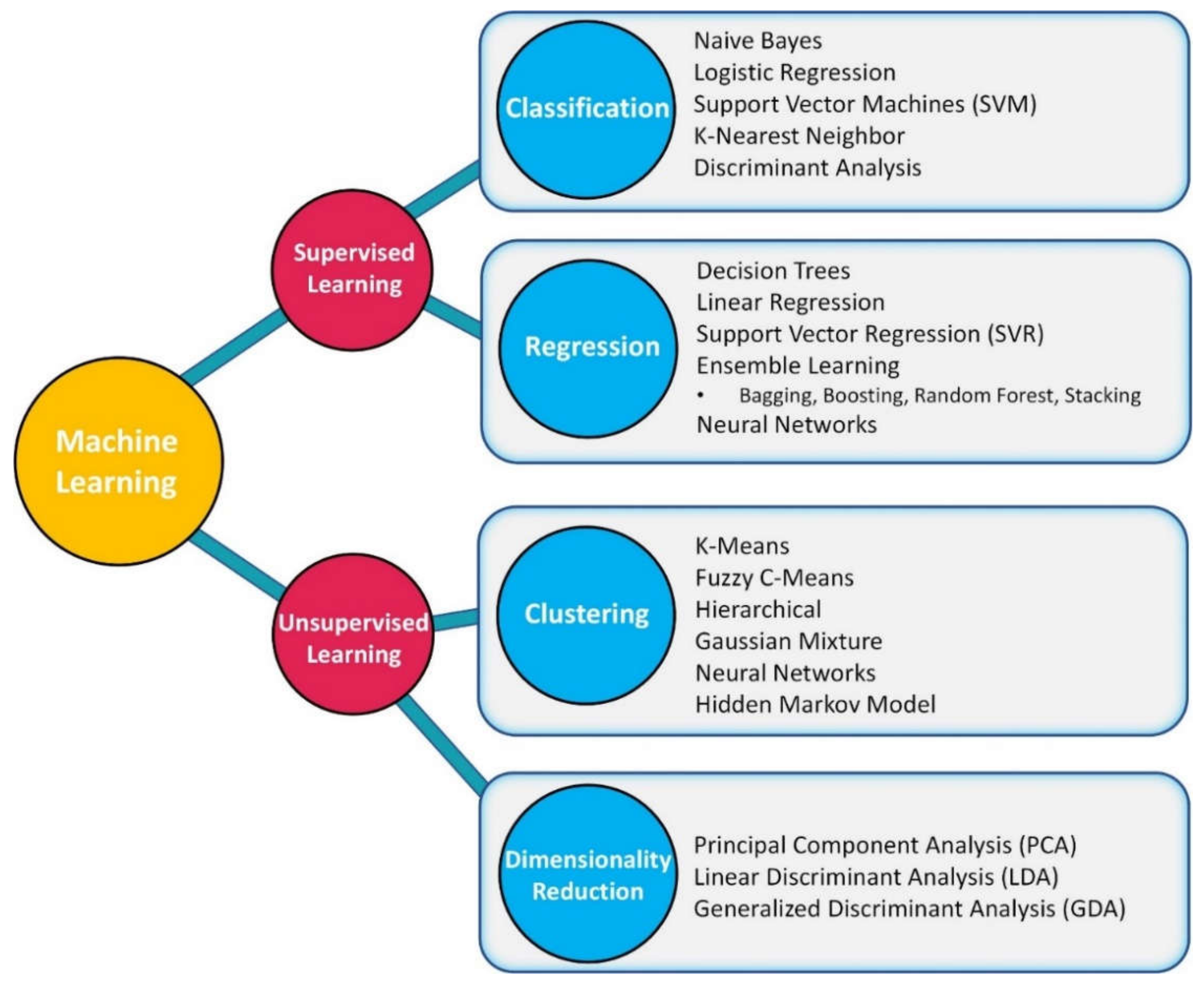
2. Machine Learning Techniques Used in GESM
2.1. Random Forest
2.2. Support Vector Machine
2.3. Alternating Decision Tree
2.4. Naïve Bayes Tree
2.5. Logistic Model Tree
2.6. Artificial Neural Network
2.7. Boosted Regression Trees
3. ML Methodology of GESM
3.1. Inventory Map of Gullies
3.2. Gully Conditioning Factors
3.3. Multi-Collinearity Assessment
3.4. Model Development and Performance Evaluation
3.4.1. Accuracy
3.4.2. Kappa Coefficient
3.4.3. Receiver Operating Characteristic (ROC) Curve
3.5. Software and Programming Languages Used for GESM
- ArcGIS and SAGA-GIS software are typically implemented for preprocessing steps, such as preparing the inventory map of gullies and GEFs.
- MATLAB, Python, and R programming languages are used for multi-collinearity assessment, ML model development and performance evaluation.
4. Comparative Performance Analysis of ML
5. Conclusions and Recommendations
Author Contributions
Funding
Data Availability Statement
Conflicts of Interest
References
- Valentin, C.; Poesen, J.; Li, Y. Gully erosion: Impacts, factors and control. Catena 2005, 63, 132–153. [Google Scholar] [CrossRef]
- Boardman, J.; Parsons, A.; Holland, R.; Holmes, P.; Washington, R. Development of badlands and gullies in the Sneeuberg, Great Karoo, South Africa. Catena 2003, 50, 165–184. [Google Scholar] [CrossRef]
- Foster, G. Understanding ephemeral gully erosion. Soil Conserv. 1986, 2, 90–125. [Google Scholar]
- Soil Science Society of America. Glossary of Soil Science Terms; Soil Science Society of America: Washington, DC, USA, 2001. [Google Scholar]
- Poesen, J. Contribution of gully erosion to sediment production. In Proceedings of the Erosion and Sediment Yield: Global and Regional Perspectives: Proceedings of an International Symposium, Exeter, UK, 15–19 July 1996; p. 251. [Google Scholar]
- Stout, B. Soil erosion by water, some measures for its control on cultivated lands. In FAO Agricultural Development Economics Working Paper; FAO: Roma, Italy, 1965. [Google Scholar]
- U.S.C. Service. Procedure for determining rates of land damage, land depreciation and volume of sediment produced by gully erosion. Guidel. Watershed Manag. 1977, 1, 125–141. [Google Scholar]
- Poesen, J.; Nachtergaele, J.; Verstraeten, G.; Valentin, C. Gully erosion and environmental change: Importance and research needs. Catena 2003, 50, 91–133. [Google Scholar] [CrossRef]
- Chaplot, V.; Le Brozec, E.C.; Silvera, N.; Valentin, C. Spatial and temporal assessment of linear erosion in catchments under sloping lands of northern Laos. Catena 2005, 63, 167–184. [Google Scholar] [CrossRef]
- Zucca, C.; Canu, A.; Della Peruta, R. Effects of land use and landscape on spatial distribution and morphological features of gullies in an agropastoral area in Sardinia (Italy). Catena 2006, 68, 87–95. [Google Scholar] [CrossRef]
- Gomez Gutierrez, A.; Schnabel, S.; Felicísimo, Á.M. Modelling the occurrence of gullies in rangelands of southwest Spain. Earth Surf. Process. Landf. J. Br. Geomorphol. Res. Group 2009, 34, 1894–1902. [Google Scholar] [CrossRef]
- Popp, J.H.; Hyatt, D.E.; Hoag, D. Modeling environmental condition with indices: A case study of sustainability and soil resources. Ecol. Model. 2000, 130, 131–143. [Google Scholar] [CrossRef] [Green Version]
- Sidorchuk, A.; Märker, M.; Moretti, S.; Rodolfi, G. Gully erosion modelling and landscape response in the Mbuluzi River catchment of Swaziland. Catena 2003, 50, 507–525. [Google Scholar] [CrossRef]
- Conoscenti, C.; Angileri, S.; Cappadonia, C.; Rotigliano, E.; Agnesi, V.; Märker, M. Gully erosion susceptibility assessment by means of GIS-based logistic regression: A case of Sicily (Italy). Geomorphology 2014, 204, 399–411. [Google Scholar] [CrossRef] [Green Version]
- Kumar, B. Carbon sequestration potential of tropical homegardens. In Tropical Homegardens; Springer: Berlin/Heidelberg, Germany, 2006; pp. 185–204. [Google Scholar]
- Daggupati, P.; Sheshukov, A.Y.; Douglas-Mankin, K.R. Evaluating ephemeral gullies with a process-based topographic index model. Catena 2014, 113, 177–186. [Google Scholar] [CrossRef]
- Wu, T.; Pan, C.; Li, C.; Luo, M.; Wang, X. A field investigation on ephemeral gully erosion processes under different upslope inflow and sediment conditions. J. Hydrol. 2019, 572, 517–527. [Google Scholar] [CrossRef]
- Akgün, A.; Türk, N. Mapping erosion susceptibility by a multivariate statistical method: A case study from the Ayvalık region, NW Turkey. Comput. Geosci. 2011, 37, 1515–1524. [Google Scholar] [CrossRef]
- Conoscenti, C.; Agnesi, V.; Cama, M.; Caraballo-Arias, N.A.; Rotigliano, E. Assessment of gully erosion susceptibility using multivariate adaptive regression splines and accounting for terrain connectivity. Land Degrad. Dev. 2018, 29, 724–736. [Google Scholar] [CrossRef]
- Knisel, W.G. CREAMS: A Field Scale Model for Chemicals, Runoff, and Erosion from Agricultural Management Systems; US Department of Agriculture, Science and Education Administration: Washington, DC, USA, 1980.
- Merkel, W.; Woodward, D.; Clarke, C. Ephemeral Gully Erosion Model (EGEM); Woodward, Inc.: Fort Collins, CO, USA, 1988. [Google Scholar]
- Leonard, R.; Knisel, W.; Still, D. GLEAMS: Groundwater loading effects of agricultural management systems. Trans. ASAE 1987, 30, 1403–1418. [Google Scholar] [CrossRef]
- Sidorchuk, A. Dynamic and static models of gully erosion. Catena 1999, 37, 401–414. [Google Scholar] [CrossRef]
- Gordon, L.; Bennett, S.; Bingner, R.; Theurer, F.; Alonso, C. Simulating ephemeral gully erosion in AnnAGNPS. Trans. ASABE 2007, 50, 857–866. [Google Scholar] [CrossRef]
- Nearing, M.A.; Foster, G.R.; Lane, L.; Finkner, S. A process-based soil erosion model for USDA-Water Erosion Prediction Project technology. Trans. ASAE 1989, 32, 1587–1593. [Google Scholar] [CrossRef]
- Bingner, R.L.; Theurer, F.D.; Yuan, Y. AnnAGNPS Technical Processes; USDA-ARS National Sedimentation Laboratory: Oxford, MS, USA, 2003.
- Moore, I.; Burch, G.; Mackenzie, D. Topographic effects on the distribution of surface soil water and the location of ephemeral gullies. Trans. ASAE 1988, 31, 1098–1107. [Google Scholar] [CrossRef]
- Thorne, C.; Zevenbergen, L.W.; Grissinger, E.; Murphey, J. Ephemeral gullies as sources of sediment. In Proceedings of the Fourth Federal Interagency Sedimentation Conference, Las Vegas, Nevada, 24–27 March 1986. [Google Scholar]
- Beven, K.J.; Kirkby, M.J. A physically based, variable contributing area model of basin hydrology/Un modèle à base physique de zone d’appel variable de l’hydrologie du bassin versant. Hydrol. Sci. J. 1979, 24, 43–69. [Google Scholar] [CrossRef] [Green Version]
- Wilson, J.P.; Gallant, J.C. Terrain Analysis: Principles and Applications; John Wiley & Sons: New York, NY, USA, 2000. [Google Scholar]
- Douglas-Mankin, K.R.; Roy, S.K.; Sheshukov, A.Y.; Biswas, A.; Gharabaghi, B.; Binns, A.; Rudra, R.; Shrestha, N.K.; Daggupati, P. A comprehensive review of ephemeral gully erosion models. Catena 2020, 195, 104901. [Google Scholar] [CrossRef]
- Vandekerckhove, L.; Poesen, J.; Wijdenes, D.O.; De Figueiredo, T. Topographical thresholds for ephemeral gully initiation in intensively cultivated areas of the Mediterranean. Catena 1998, 33, 271–292. [Google Scholar] [CrossRef]
- Sekaluvu, L.; Sheshukov, A.Y.; Hutchinson, S.L. Accuracy of topographic index models at prediction of ephemeral gullies. In Proceedings of the 2015 ASABE Annual International Meeting, Chicago, IL, USA, 3–5 May 2015; p. 1. [Google Scholar]
- Kumar, A.; Dwivedi, R.; Tiwari, K. The effects of image scale on delineation of eroded lands using remote sensing data. Int. J. Remote Sens. 1996, 17, 2135–2143. [Google Scholar] [CrossRef]
- Zinck, J.A.; López, J.; Metternicht, G.I.; Shrestha, D.P.; Vázquez-Selem, L. Mapping and modelling mass movements and gullies in mountainous areas using remote sensing and GIS techniques. Int. J. Appl. Earth Obs. Geoinf. 2001, 3, 43–53. [Google Scholar] [CrossRef]
- Manyatsi, A.M.; Ntshangase, N. Mapping of soil erosion using remotely sensed data in Zombodze South, Swaziland. Phys. Chem. Earth Parts A/B/C 2008, 33, 800–806. [Google Scholar] [CrossRef]
- Liberti, M.; Simoniello, T.; Carone, M.; Coppola, R.; D’Emilio, M.; Macchiato, M. Mapping badland areas using LANDSAT TM/ETM satellite imagery and morphological data. Geomorphology 2009, 106, 333–343. [Google Scholar] [CrossRef]
- Seutloali, K.E.; Beckedahl, H.R.; Dube, T.; Sibanda, M. An assessment of gully erosion along major armoured roads in south-eastern region of South Africa: A remote sensing and GIS approach. Geocarto Int. 2016, 31, 225–239. [Google Scholar] [CrossRef]
- Phinzi, K.; Ngetar, N.S. Mapping soil erosion in a quaternary catchment in Eastern Cape using geographic information system and remote sensing. South Afr. J. Geomat. 2017, 6, 11–29. [Google Scholar] [CrossRef] [Green Version]
- Daggupati, P.; Douglas-Mankin, K.R.; Sheshukov, A.Y. Predicting ephemeral gully location and length using topographic index models. Trans. ASABE 2013, 56, 1427–1440. [Google Scholar]
- Sheshukov, A.Y.; Sekaluvu, L.; Hutchinson, S.L. Accuracy of topographic index models at identifying ephemeral gully trajectories on agricultural fields. Geomorphology 2018, 306, 224–234. [Google Scholar] [CrossRef]
- Li, H.; Cruse, R.M.; Bingner, R.L.; Gesch, K.R.; Zhang, X. Evaluating ephemeral gully erosion impact on Zea mays L. yield and economics using AnnAGNPS. Soil Tillage Res. 2016, 155, 157–165. [Google Scholar] [CrossRef]
- Wang, R.; Zhang, S.; Pu, L.; Yang, J.; Yang, C.; Chen, J.; Guan, C.; Wang, Q.; Chen, D.; Fu, B. Gully erosion mapping and monitoring at multiple scales based on multi-source remote sensing data of the Sancha River Catchment, Northeast China. ISPRS Int. J. Geo-Inf. 2016, 5, 200. [Google Scholar] [CrossRef]
- Zhang, S.; Li, F.; Li, T.; Yang, J.; Bu, K.; Chang, L.; Wang, W.; Yan, Y. Remote sensing monitoring of gullies on a regional scale: A case study of Kebai region in Heilongjiang Province, China. Chin. Geogr. Sci. 2015, 25, 602–611. [Google Scholar] [CrossRef]
- Skytland, N. Big Data: What is Nasa Doing with Big Data Today; Open Access Government: Crewe, UK, 2012. [Google Scholar]
- Consortium, O.O. The OpenGIS Abstract Specification-Topic 7: The Earth Imagery Case; Open Geospatial Consortium, Inc.: Arlington. VA, USA, 1999. [Google Scholar]
- Vrieling, A.; Sterk, G.; Vigiak, O. Spatial evaluation of soil erosion risk in the West Usambara Mountains, Tanzania. Land Degrad. Dev. 2006, 17, 301–319. [Google Scholar] [CrossRef]
- Shruthi, R.B.; Kerle, N.; Jetten, V. Object-based gully feature extraction using high spatial resolution imagery. Geomorphology 2011, 134, 260–268. [Google Scholar] [CrossRef]
- Chlingaryan, A.; Sukkarieh, S.; Whelan, B. Machine learning approaches for crop yield prediction and nitrogen status estimation in precision agriculture: A review. Comput. Electron. Agric. 2018, 151, 61–69. [Google Scholar] [CrossRef]
- Zhang, D. Advances in Machine Learning Applications in Software Engineering; Igi Global: Hershey, PA, USA, 2006. [Google Scholar]
- Karakus, M. Function identification for the intrinsic strength and elastic properties of granitic rocks via genetic programming (GP). Comput. Geosci. 2011, 37, 1318–1323. [Google Scholar] [CrossRef]
- Ozbek, A.; Unsal, M.; Dikec, A. Estimating uniaxial compressive strength of rocks using genetic expression programming. J. Rock Mech. Geotech. Eng. 2013, 5, 325–329. [Google Scholar] [CrossRef] [Green Version]
- Vaca, R.A.; Golicher, D.J.; Cayuela, L. Using climatically based random forests to downscale coarse-grained potential natural vegetation maps in tropical Mexico. Appl. Veg. Sci. 2011, 14, 388–401. [Google Scholar] [CrossRef]
- Périé, C.; de Blois, S. Dominant forest tree species are potentially vulnerable to climate change over large portions of their range even at high latitudes. PeerJ 2016, 4, e2218. [Google Scholar] [CrossRef] [PubMed] [Green Version]
- Pouteau, R.; Meyer, J.-Y.; Taputuarai, R.; Stoll, B. Support vector machines to map rare and endangered native plants in Pacific islands forests. Ecol. Inform. 2012, 9, 37–46. [Google Scholar] [CrossRef]
- Parisouj, P.; Mohebzadeh, H.; Lee, T. Employing Machine Learning Algorithms for Streamflow Prediction: A Case Study of Four River Basins with Different Climatic Zones in the United States. Water Resour. Manag. 2020, 34, 4113–4131. [Google Scholar] [CrossRef]
- Noymanee, J.; Theeramunkong, T. Flood Forecasting with Machine Learning Technique on Hydrological Modeling. Procedia Comput. Sci. 2019, 156, 377–386. [Google Scholar] [CrossRef]
- Chen, C.; He, W.; Zhou, H.; Xue, Y.; Zhu, M. A comparative study among machine learning and numerical models for simulating groundwater dynamics in the Heihe River Basin, northwestern China. Sci. Rep. 2020, 10, 3904. [Google Scholar] [CrossRef] [PubMed] [Green Version]
- Senthilnath, J.; Dokania, A.; Kandukuri, M.; Ramesh, K.; Anand, G.; Omkar, S. Detection of tomatoes using spectral-spatial methods in remotely sensed RGB images captured by UAV. Biosyst. Eng. 2016, 146, 16–32. [Google Scholar] [CrossRef]
- Su, Y.-X.; Xu, H.; Yan, L.-J. Support vector machine-based open crop model (SBOCM): Case of rice production in China. Saudi J. Biol. Sci. 2017, 24, 537–547. [Google Scholar] [CrossRef]
- Kung, H.-Y.; Kuo, T.-H.; Chen, C.-H.; Tsai, P.-Y. Accuracy analysis mechanism for agriculture data using the ensemble neural network method. Sustainability 2016, 8, 735. [Google Scholar] [CrossRef] [Green Version]
- Arabameri, A.; Chen, W.; Loche, M.; Zhao, X.; Li, Y.; Lombardo, L.; Cerda, A.; Pradhan, B.; Bui, D.T. Comparison of machine learning models for gully erosion susceptibility mapping. Geosci. Front. 2019, 11, 1609–1620. [Google Scholar] [CrossRef]
- Bui, D.T.; Tuan, T.A.; Klempe, H.; Pradhan, B.; Revhaug, I. Spatial prediction models for shallow landslide hazards: A comparative assessment of the efficacy of support vector machines, artificial neural networks, kernel logistic regression, and logistic model tree. Landslides 2016, 13, 361–378. [Google Scholar]
- Phinzi, K.; Abriha, D.; Bertalan, L.; Holb, I.; Szabó, S. Machine Learning for Gully Feature Extraction Based on a Pan-Sharpened Multispectral Image: Multiclass vs. Binary Approach. ISPRS Int. J. Geo-Inf. 2020, 9, 252. [Google Scholar] [CrossRef] [Green Version]
- Märker, M.; Pelacani, S.; Schröder, B. A functional entity approach to predict soil erosion processes in a small Plio-Pleistocene Mediterranean catchment in Northern Chianti, Italy. Geomorphology 2011, 125, 530–540. [Google Scholar] [CrossRef]
- Voyant, C.; Notton, G.; Kalogirou, S.; Nivet, M.-L.; Paoli, C.; Motte, F.; Fouilloy, A. Machine learning methods for solar radiation forecasting: A review. Renew. Energy 2017, 105, 569–582. [Google Scholar] [CrossRef]
- Liakos, K.G.; Busato, P.; Moshou, D.; Pearson, S.; Bochtis, D. Machine learning in agriculture: A review. Sensors 2018, 18, 2674. [Google Scholar] [CrossRef]
- Breiman, L. Random forests. Mach. Learn. 2001, 45, 5–32. [Google Scholar] [CrossRef] [Green Version]
- Amiri, M.; Pourghasemi, H.R.; Ghanbarian, G.A.; Afzali, S.F. Assessment of the importance of gully erosion effective factors using Boruta algorithm and its spatial modeling and mapping using three machine learning algorithms. Geoderma 2019, 340, 55–69. [Google Scholar] [CrossRef]
- Micheletti, N.; Foresti, L.; Robert, S.; Leuenberger, M.; Pedrazzini, A.; Jaboyedoff, M.; Kanevski, M. Machine learning feature selection methods for landslide susceptibility mapping. Math. Geosci. 2014, 46, 33–57. [Google Scholar] [CrossRef] [Green Version]
- Liaw, A.; Wiener, M. Classification and regression by randomForest. R News 2002, 2, 18–22. [Google Scholar]
- Pourghasemi, H.R.; Sadhasivam, N.; Kariminejad, N.; Collins, A.L. Gully erosion spatial modelling: Role of machine learning algorithms in selection of the best controlling factors and modelling process. Geosci. Front. 2020, 11, 2207–2219. [Google Scholar] [CrossRef]
- Naghibi, S.A.; Pourghasemi, H.R.; Dixon, B. GIS-based groundwater potential mapping using boosted regression tree, classification and regression tree, and random forest machine learning models in Iran. Environ. Monit. Assess. 2016, 188, 44. [Google Scholar] [CrossRef] [PubMed]
- Wiesmeier, M.; Barthold, F.; Blank, B.; Kögel-Knabner, I. Digital mapping of soil organic matter stocks using Random Forest modeling in a semi-arid steppe ecosystem. Plant Soil 2011, 340, 7–24. [Google Scholar] [CrossRef]
- Cortes, C.; Vapnik, V. Support-vector networks. Mach. Learn. 1995, 20, 273–297. [Google Scholar] [CrossRef]
- Mountrakis, G.; Im, J.; Ogole, C. Support vector machines in remote sensing: A review. ISPRS J. Photogramm. Remote Sens. 2011, 66, 247–259. [Google Scholar] [CrossRef]
- Kavzoglu, T.; Sahin, E.K.; Colkesen, I. Landslide susceptibility mapping using GIS-based multi-criteria decision analysis, support vector machines, and logistic regression. Landslides 2014, 11, 425–439. [Google Scholar] [CrossRef]
- Kalantar, B.; Pradhan, B.; Naghibi, S.A.; Motevalli, A.; Mansor, S. Assessment of the effects of training data selection on the landslide susceptibility mapping: A comparison between support vector machine (SVM), logistic regression (LR) and artificial neural networks (ANN). Geomat. Nat. Hazards Risk 2018, 9, 49–69. [Google Scholar] [CrossRef]
- Basak, D.; Pal, S.; Patranabis, D.C. Support vector regression. Neural Inf. Process.-Lett. Rev. 2007, 11, 203–224. [Google Scholar]
- Vapnik, V. The Nature of Statistical Learning Theory; Springer Science & Business Media: Berlin/Heidelberg, Germany, 2013. [Google Scholar]
- Bui, D.T.; Pradhan, B.; Lofman, O.; Revhaug, I.; Dick, O.B. Landslide susceptibility assessment in the Hoa Binh province of Vietnam: A comparison of the Levenberg–Marquardt and Bayesian regularized neural networks. Geomorphology 2012, 171, 12–29. [Google Scholar]
- Pradhan, B. A comparative study on the predictive ability of the decision tree, support vector machine and neuro-fuzzy models in landslide susceptibility mapping using GIS. Comput. Geosci. 2013, 51, 350–365. [Google Scholar] [CrossRef]
- Freund, Y.; Mason, L. The alternating decision tree learning algorithm. In Proceedings of the ICML, Bled, Slovenia, 27–30 June 1999; pp. 124–133. [Google Scholar]
- Sok, H.K.; Ooi, M.P.-L.; Kuang, Y.C.; Demidenko, S. Multivariate alternating decision trees. Pattern Recognit. 2016, 50, 195–209. [Google Scholar] [CrossRef]
- Pham, B.T.; Bui, D.T.; Prakash, I. Landslide susceptibility assessment using bagging ensemble based alternating decision trees, logistic regression and J48 decision trees methods: A comparative study. Geotech. Geol. Eng. 2017, 35, 2597–2611. [Google Scholar] [CrossRef]
- Farid, D.M.; Zhang, L.; Rahman, C.M.; Hossain, M.A.; Strachan, R. Hybrid decision tree and naïve Bayes classifiers for multi-class classification tasks. Expert Syst. Appl. 2014, 41, 1937–1946. [Google Scholar] [CrossRef]
- Wang, L.-M.; Li, X.-L.; Cao, C.-H.; Yuan, S.-M. Combining decision tree and Naive Bayes for classification. Knowl.-Based Syst. 2006, 19, 511–515. [Google Scholar] [CrossRef]
- Kohavi, R. Scaling up the accuracy of naive-bayes classifiers: A decision-tree hybrid. In Proceedings of the Kdd, Portland, OR, USA, 2–4 August 1996; pp. 202–207. [Google Scholar]
- Chen, W.; Shirzadi, A.; Shahabi, H.; Ahmad, B.B.; Zhang, S.; Hong, H.; Zhang, N. A novel hybrid artificial intelligence approach based on the rotation forest ensemble and naïve Bayes tree classifiers for a landslide susceptibility assessment in Langao County, China. Geomat. Nat. Hazards Risk 2017, 8, 1955–1977. [Google Scholar] [CrossRef] [Green Version]
- Landwehr, N.; Hall, M.; Frank, E. Logistic model trees. Mach. Learn. 2005, 59, 161–205. [Google Scholar] [CrossRef] [Green Version]
- Heung, B.; Hodúl, M.; Schmidt, M.G. Comparing the use of training data derived from legacy soil pits and soil survey polygons for mapping soil classes. Geoderma 2017, 290, 51–68. [Google Scholar] [CrossRef]
- Chen, W.; Xie, X.; Wang, J.; Pradhan, B.; Hong, H.; Bui, D.T.; Duan, Z.; Ma, J. A comparative study of logistic model tree, random forest, and classification and regression tree models for spatial prediction of landslide susceptibility. Catena 2017, 151, 147–160. [Google Scholar] [CrossRef] [Green Version]
- Chen, W.; Pradhan, B.; Li, S.; Shahabi, H.; Rizeei, H.M.; Hou, E.; Wang, S. Novel hybrid integration approach of bagging-based fisher’s linear discriminant function for groundwater potential analysis. Nat. Resour. Res. 2019, 28, 1239–1258. [Google Scholar] [CrossRef]
- Breiman, L.; Friedman, J.; Olshen, R.; Stone, C. Classification and regression trees. Biometrics 1984, 40, 358–361. [Google Scholar]
- Lee, S.; Jun, C.-H. Fast incremental learning of logistic model tree using least angle regression. Expert Syst. Appl. 2018, 97, 137–145. [Google Scholar] [CrossRef]
- Wang, L.-J.; Guo, M.; Sawada, K.; Lin, J.; Zhang, J. A comparative study of landslide susceptibility maps using logistic regression, frequency ratio, decision tree, weights of evidence and artificial neural network. Geosci. J. 2016, 20, 117–136. [Google Scholar] [CrossRef]
- Kadavi, P.R.; Lee, C.-W.; Lee, S. Landslide-susceptibility mapping in Gangwon-do, South Korea, using logistic regression and decision tree models. Environ. Earth Sci. 2019, 78, 116. [Google Scholar] [CrossRef]
- Rahmati, O.; Tahmasebipour, N.; Haghizadeh, A.; Pourghasemi, H.R.; Feizizadeh, B. Evaluation of different machine learning models for predicting and mapping the susceptibility of gully erosion. Geomorphology 2017, 298, 118–137. [Google Scholar] [CrossRef]
- Ermini, L.; Catani, F.; Casagli, N. Artificial neural networks applied to landslide susceptibility assessment. Geomorphology 2005, 66, 327–343. [Google Scholar] [CrossRef]
- Zare, M.; Pourghasemi, H.R.; Vafakhah, M.; Pradhan, B. Landslide susceptibility mapping at Vaz Watershed (Iran) using an artificial neural network model: A comparison between multilayer perceptron (MLP) and radial basic function (RBF) algorithms. Arab. J. Geosci. 2013, 6, 2873–2888. [Google Scholar] [CrossRef]
- Gorsevski, P.V.; Brown, M.K.; Panter, K.; Onasch, C.M.; Simic, A.; Snyder, J. Landslide detection and susceptibility mapping using LiDAR and an artificial neural network approach: A case study in the Cuyahoga Valley National Park, Ohio. Landslides 2016, 13, 467–484. [Google Scholar] [CrossRef]
- Yegnanarayana, B. Artificial Neural Networks; PHI Learning Pvt. Ltd.: Delhi, India, 2009. [Google Scholar]
- Peethambaran, B.; Anbalagan, R.; Kanungo, D.; Goswami, A.; Shihabudheen, K. A comparative evaluation of supervised machine learning algorithms for township level landslide susceptibility zonation in parts of Indian Himalayas. CATENA 2020, 195, 104751. [Google Scholar] [CrossRef]
- Bishop, C.M. Neural Networks for Pattern Recognition; Oxford University Press: Oxford, UK, 1995. [Google Scholar]
- Shen, C.; Wang, L.; Li, Q. Optimization of injection molding process parameters using combination of artificial neural network and genetic algorithm method. J. Mater. Process. Technol. 2007, 183, 412–418. [Google Scholar] [CrossRef]
- Choi, J.; Oh, H.-J.; Lee, H.-J.; Lee, C.; Lee, S. Combining landslide susceptibility maps obtained from frequency ratio, logistic regression, and artificial neural network models using ASTER images and GIS. Eng. Geol. 2012, 124, 12–23. [Google Scholar] [CrossRef]
- Lyashevska, O.; Harma, C.; Minto, C.; Clarke, M.; Brophy, D. Long-term trends in herring growth primarily linked to temperature by gradient boosting regression trees. Ecol. Inform. 2020, 60, 101154. [Google Scholar] [CrossRef]
- Aertsen, W.; Kint, V.; Van Orshoven, J.; Özkan, K.; Muys, B. Comparison and ranking of different modelling techniques for prediction of site index in Mediterranean mountain forests. Ecol. Model. 2010, 221, 1119–1130. [Google Scholar] [CrossRef]
- Hu, Y.; Dai, Z.; Guldmann, J.-M. Modeling the impact of 2D/3D urban indicators on the urban heat island over different seasons: A boosted regression tree approach. J. Environ. Manag. 2020, 266, 110424. [Google Scholar] [CrossRef] [PubMed]
- Sayegh, A.; Tate, J.E.; Ropkins, K. Understanding how roadside concentrations of NOx are influenced by the background levels, traffic density, and meteorological conditions using Boosted Regression Trees. Atmos. Environ. 2016, 127, 163–175. [Google Scholar] [CrossRef]
- Zhang, W.; Du, Z.; Zhang, D.; Yu, S.; Hao, Y. Boosted regression tree model-based assessment of the impacts of meteorological drivers of hand, foot and mouth disease in Guangdong, China. Sci. Total Environ. 2016, 553, 366–371. [Google Scholar] [CrossRef] [PubMed]
- Froeschke, J.T.; Froeschke, B.F. Spatio-temporal predictive model based on environmental factors for juvenile spotted seatrout in Texas estuaries using boosted regression trees. Fish. Res. 2011, 111, 131–138. [Google Scholar] [CrossRef]
- Shruthi, R.B.; Kerle, N.; Jetten, V.; Stein, A. Object-based gully system prediction from medium resolution imagery using Random Forests. Geomorphology 2014, 216, 283–294. [Google Scholar] [CrossRef]
- Angileri, S.E.; Conoscenti, C.; Hochschild, V.; Märker, M.; Rotigliano, E.; Agnesi, V. Water erosion susceptibility mapping by applying stochastic gradient treeboost to the Imera Meridionale river basin (Sicily, Italy). Geomorphology 2016, 262, 61–76. [Google Scholar] [CrossRef]
- Garosi, Y.; Sheklabadi, M.; Conoscenti, C.; Pourghasemi, H.R.; Van Oost, K. Assessing the performance of GIS-based machine learning models with different accuracy measures for determining susceptibility to gully erosion. Sci. Total Environ. 2019, 664, 1117–1132. [Google Scholar] [CrossRef] [PubMed]
- Makaya, N.P.; Mutanga, O.; Kiala, Z.; Dube, T.; Seutloali, K.E. Assessing the potential of Sentinel-2 MSI sensor in detecting and mapping the spatial distribution of gullies in a communal grazing landscape. Phys. Chem. Earth Parts A/B/C 2019, 112, 66–74. [Google Scholar] [CrossRef]
- Gayen, A.; Pourghasemi, H.R.; Saha, S.; Keesstra, S.; Bai, S. Gully erosion susceptibility assessment and management of hazard-prone areas in India using different machine learning algorithms. Sci. Total Environ. 2019, 668, 124–138. [Google Scholar] [CrossRef] [PubMed]
- Arabameri, A.; Pradhan, B.; Rezaei, K. Gully erosion zonation mapping using integrated geographically weighted regression with certainty factor and random forest models in GIS. J. Environ. Manag. 2019, 232, 928–942. [Google Scholar] [CrossRef]
- Arabameri, A.; Cerda, A.; Pradhan, B.; Tiefenbacher, J.P.; Lombardo, L.; Bui, D.T. A methodological comparison of head-cut based gully erosion susceptibility models: Combined use of statistical and artificial intelligence. Geomorphology 2020, 359, 107136. [Google Scholar] [CrossRef]
- Arabameri, A.; Sadhasivam, N.; Turabieh, H.; Mafarja, M.; Rezaie, F.; Pal, S.C.; Santosh, M. Credal decision tree based novel ensemble models for spatial assessment of gully erosion and sustainable management. Sci. Rep. 2021, 11, 3147. [Google Scholar] [CrossRef] [PubMed]
- Roy, J.; Saha, S. Integration of artificial intelligence with meta classifiers for the gully erosion susceptibility assessment in Hinglo river basin, Eastern India. Adv. Space Res. 2021, 67, 316–333. [Google Scholar] [CrossRef]
- Chowdhuri, I.; Pal, S.C.; Saha, A.; Chakrabortty, R.; Roy, P. Evaluation of different DEMs for gully erosion susceptibility mapping using in-situ field measurement and validation. Ecol. Inform. 2021, 65, 101425. [Google Scholar] [CrossRef]
- Wang, F.; Sahana, M.; Pahlevanzadeh, B.; Pal, S.C.; Shit, P.K.; Piran, M.J.; Janizadeh, S.; Band, S.S.; Mosavi, A. Applying different resampling strategies in machine learning models to predict head-cut gully erosion susceptibility. Alex. Eng. J. 2021, 60, 5813–5829. [Google Scholar] [CrossRef]
- Arabameri, A.; Rezaie, F.; Pal, S.C.; Cerda, A.; Saha, A.; Chakrabortty, R.; Lee, S. Modelling of piping collapses and gully headcut landforms: Evaluating topographic variables from different types of DEM. Geosci. Front. 2021, 12, 101230. [Google Scholar] [CrossRef]
- Yang, A.; Wang, C.; Pang, G.; Long, Y.; Wang, L.; Cruse, R.M.; Yang, Q. Gully Erosion Susceptibility Mapping in Highly Complex Terrain Using Machine Learning Models. ISPRS Int. J. Geo-Inf. 2021, 10, 680. [Google Scholar] [CrossRef]
- Süzen, M.L.; Doyuran, V. A comparison of the GIS based landslide susceptibility assessment methods: Multivariate versus bivariate. Environ. Geol. 2004, 45, 665–679. [Google Scholar] [CrossRef]
- Schicker, R.; Moon, V. Comparison of bivariate and multivariate statistical approaches in landslide susceptibility mapping at a regional scale. Geomorphology 2012, 161, 40–57. [Google Scholar] [CrossRef]
- Dou, J.; Yamagishi, H.; Pourghasemi, H.R.; Yunus, A.P.; Song, X.; Xu, Y.; Zhu, Z. An integrated artificial neural network model for the landslide susceptibility assessment of Osado Island, Japan. Nat. Hazards 2015, 78, 1749–1776. [Google Scholar] [CrossRef]
- Rahmati, O.; Haghizadeh, A.; Pourghasemi, H.R.; Noormohamadi, F. Gully erosion susceptibility mapping: The role of GIS-based bivariate statistical models and their comparison. Nat. Hazards 2016, 82, 1231–1258. [Google Scholar] [CrossRef]
- Conoscenti, C.; Di Maggio, C.; Rotigliano, E. Soil erosion susceptibility assessment and validation using a geostatistical multivariate approach: A test in Southern Sicily. Nat. Hazards 2008, 46, 287–305. [Google Scholar] [CrossRef]
- Jahantigh, M.; Pessarakli, M. Causes and effects of gully erosion on agricultural lands and the environment. Commun. Soil Sci. Plant Anal. 2011, 42, 2250–2255. [Google Scholar] [CrossRef]
- Kheir, R.B.; Wilson, J.; Deng, Y. Use of terrain variables for mapping gully erosion susceptibility in Lebanon. Earth Surf. Process. Landf. J. Br. Geomorphol. Res. Group 2007, 32, 1770–1782. [Google Scholar] [CrossRef]
- Wells, R.R.; Bennett, S.J.; Alonso, C.V. Effect of soil texture, tailwater height, and pore-water pressure on the morphodynamics of migrating headcuts in upland concentrated flows. Earth Surf. Process. Landf. J. Br. Geomorphol. Res. Group 2009, 34, 1867–1877. [Google Scholar] [CrossRef]
- Agnesi, V.; Angileri, S.; Cappadonia, C.; Conoscenti, C.; Rotigliano, E. Multi parametric gis analysis to assess gully erosion susceptibility: A test in southern sicily, italy. Landf. Anal. 2011, 17, 15–20. [Google Scholar]
- Conoscenti, C.; Agnesi, V.; Angileri, S.; Cappadonia, C.; Rotigliano, E.; Märker, M. A GIS-based approach for gully erosion susceptibility modelling: A test in Sicily, Italy. Environ. Earth Sci. 2013, 70, 1179–1195. [Google Scholar] [CrossRef]
- Mararakanye, N.; Sumner, P.D. Gully erosion: A comparison of contributing factors in two catchments in South Africa. Geomorphology 2017, 288, 99–110. [Google Scholar] [CrossRef] [Green Version]
- Pourghasemi, H.R.; Yousefi, S.; Kornejady, A.; Cerdà, A. Performance assessment of individual and ensemble data-mining techniques for gully erosion modeling. Sci. Total Environ. 2017, 609, 764–775. [Google Scholar] [CrossRef] [PubMed]
- Rahmati, O.; Tahmasebipour, N.; Haghizadeh, A.; Pourghasemi, H.R.; Feizizadeh, B. Evaluating the influence of geo-environmental factors on gully erosion in a semi-arid region of Iran: An integrated framework. Sci. Total Environ. 2017, 579, 913–927. [Google Scholar] [CrossRef] [PubMed]
- Gutiérrez, Á.G.; Schnabel, S.; Contador, F.L. Gully erosion, land use and topographical thresholds during the last 60 years in a small rangeland catchment in SW Spain. Land Degrad. Dev. 2009, 20, 535–550. [Google Scholar] [CrossRef]
- Shahin, K.A.; Hassan, N. Sources of shared variability among body shape characters at marketing age in New Zealand White and Egyptian rabbit breeds. In Annales de Zootechnie; EDP Sciences: Les Ulis, France, 2000; pp. 435–445. [Google Scholar]
- Bui, D.T.; Pradhan, B.; Lofman, O.; Revhaug, I.; Dick, O.B. Spatial prediction of landslide hazards in Hoa Binh province (Vietnam): A comparative assessment of the efficacy of evidential belief functions and fuzzy logic models. Catena 2012, 96, 28–40. [Google Scholar]
- Guzzetti, F.; Reichenbach, P.; Ardizzone, F.; Cardinali, M.; Galli, M. Estimating the quality of landslide susceptibility models. Geomorphology 2006, 81, 166–184. [Google Scholar] [CrossRef]
- Landis, J.R.; Koch, G.G. The measurement of observer agreement for categorical data. Biometrics 1977, 33, 159–174. [Google Scholar] [CrossRef] [Green Version]
- Bradley, A.P. The use of the area under the ROC curve in the evaluation of machine learning algorithms. Pattern Recognit. 1997, 30, 1145–1159. [Google Scholar] [CrossRef] [Green Version]
- Egan, J.P.; Egan, J.P. Signal Detection Theory and ROC-Analysis; Academic press: Cambridge, MA, USA, 1975. [Google Scholar]
- Mandrekar, J.N. Receiver operating characteristic curve in diagnostic test assessment. J. Thorac. Oncol. 2010, 5, 1315–1316. [Google Scholar] [CrossRef] [PubMed] [Green Version]
- Hajian-Tilaki, K. Receiver operating characteristic (ROC) curve analysis for medical diagnostic test evaluation. Casp. J. Intern. Med. 2013, 4, 627. [Google Scholar]
- Yesilnacar, E.; Topal, T. Landslide susceptibility mapping: A comparison of logistic regression and neural networks methods in a medium scale study, Hendek region (Turkey). Eng. Geol. 2005, 79, 251–266. [Google Scholar] [CrossRef]
- Svoray, T.; Michailov, E.; Cohen, A.; Rokah, L.; Sturm, A. Predicting gully initiation: Comparing data mining techniques, analytical hierarchy processes and the topographic threshold. Earth Surf. Process. Landf. 2012, 37, 607–619. [Google Scholar] [CrossRef]
- Fernandes, J.; Bateira, C.; Soares, L.; Faria, A.; Oliveira, A.; Hermenegildo, C.; Moura, R.; Gonçalves, J. SIMWE model application on susceptibility analysis to bank gully erosion in Alto Douro Wine Region agricultural terraces. Catena 2017, 153, 39–49. [Google Scholar] [CrossRef]
- Kuhnert, P.M.; Henderson, A.K.; Bartley, R.; Herr, A. Incorporating uncertainty in gully erosion calculations using the random forests modelling approach. Environmetrics 2010, 21, 493–509. [Google Scholar] [CrossRef]
- Zhang, X.; Fan, J.; Liu, Q.; Xiong, D. The contribution of gully erosion to total sediment production in a small watershed in Southwest China. Phys. Geogr. 2018, 39, 246–263. [Google Scholar] [CrossRef]
- Arabameri, A.; Rezaei, K.; Pourghasemi, H.R.; Lee, S.; Yamani, M. GIS-based gully erosion susceptibility mapping: A comparison among three data-driven models and AHP knowledge-based technique. Environ. Earth Sci. 2018, 77, 628. [Google Scholar] [CrossRef]
- Kantardzic, M. Data Mining: Concepts, Models, Methods, and Algorithms; John Wiley & Sons: New York, NY, USA, 2011. [Google Scholar]
- Marjanović, M.; Kovačević, M.; Bajat, B.; Voženílek, V. Landslide susceptibility assessment using SVM machine learning algorithm. Eng. Geol. 2011, 123, 225–234. [Google Scholar] [CrossRef]
- Xu, C.; Dai, F.; Xu, X.; Lee, Y.H. GIS-based support vector machine modeling of earthquake-triggered landslide susceptibility in the Jianjiang River watershed, China. Geomorphology 2012, 145, 70–80. [Google Scholar] [CrossRef]
- Goh, A.T.; Goh, S. Support vector machines: Their use in geotechnical engineering as illustrated using seismic liquefaction data. Comput. Geotech. 2007, 34, 410–421. [Google Scholar] [CrossRef]
- Samui, P. Support vector classifier analysis of slope. Geomat. Nat. Hazards Risk 2013, 4, 1–12. [Google Scholar] [CrossRef]

| Abbreviation | Definition | Abbreviation | Definition |
|---|---|---|---|
| ADTree | Alternating Decision Tree | GLEAMS | Groundwater Loading Effects of Agricultural Management Systems |
| ALOS | Advanced Land Observing Satellite | GPS | Global Positioning System |
| ANN | Artificial Neural Network | GWR | Geographically Weighted Regression |
| AnnAGNPS | Annualized Agricultural Non-Point Source | LMT | Logistic Model Tree |
| ASTER | Advanced Spaceborne Thermal Emission and Reflection Radiometer | MAE | Mean Absolute Error |
| AUC | Area Under the ROC Curve | ML | Machine Learning |
| AW3D30 | World 3D-30 m | MLFF-ANN | Multi-Layer Feed-Forward ANN |
| BP | Back Propagation | MLP | Multilayer Perceptron Neural Network |
| BRT | Boosted Regression Tree | NBTree | Naïve Bayes Tree |
| CART | Classification And Regression Trees | NPV | Negative Predictive Value |
| CCE | Calcium Carbonate Equivalent | OOB | Out-Of-Bag |
| CDT-ADTree | Credal Decision Tree-Alternative Decision Tree | PPV | Positive Predictive Value |
| CDT-BA | Credal Decision Tree-Bagging | RBF | Radial Basis Function |
| CDT-DA | Credal Decision Tree-Dagging | REGEM | Revised Ephemeral Gully Erosion Model |
| CDT-RF | Credal Decision Tree Rotation Forest | RF | Random Forest |
| Cforest | Conditional Inference Forests | RMSE | Root Mean Square Error |
| CF | Certainty Factor | ROC | Receiver Operating Characteristic |
| CREAMS | Chemicals, Runoff, and Erosion from Agricultural Management Systems | SA | Slope-Area |
| CTI | Compound Topographic Index | SLFF-ANN | Single-Layer Feed-Forward ANN |
| DEMs | Digital Elevation Models | SOC | Soil Organic Carbon |
| DLNN | Deep Learning Neural Network | SRTM | Shuttle Radar Topography Mission |
| DS-BL | DS-Binary Logistic | SVM | Support Vector Machine |
| DS-BLW | DS-Binary Logitraw | TN | True Negative |
| DS-RL | DS-Reg Linear | TN | Tree Net |
| DS-RLG | DS-Reg Logistic | TOL | Tolerance |
| EGEM | Ephemeral Gully Erosion Model | TP | True Positive |
| ETM+ | Landsat Enhanced Thematic Mapper Plus | TPI | Topographic Position Index |
| FN | False Negative | TSS | True Skill Statistic |
| FP | False Positive | TWI | Topographic Wetness Index |
| GEFs | Geo-Environmental Factors | UAV | Unmanned Aerial Vehicle |
| GEIM | Gully Erosion Inventory Map | VIF | Variance Inflation Factor |
| GESM | Gully Erosion Susceptibility Mapping | WEPP | Water Erosion Prediction Project |
| GESMs | Gully Erosion Susceptibility Maps | XGBoost | Extreme Gradient Boosting |
| Paper | Year | Publisher | Journal | SNIP | CiteScore | h-Index |
|---|---|---|---|---|---|---|
| [65] | 2011 | ScienceDirect | Geomorphology | 1.504 | 7.3 | 171 |
| [18] | 2011 | ScienceDirect | Computers & Geosciences | 1.664 | 7 | 131 |
| [113] | 2014 | ScienceDirect | Geomorphology | 1.504 | 7.3 | 171 |
| [114] | 2016 | ScienceDirect | Geomorphology | 1.504 | 7.3 | 171 |
| [98] | 2017 | ScienceDirect | Geomorphology | 1.504 | 7.3 | 171 |
| [115] | 2019 | ScienceDirect | Science of The Total Environment | 2.175 | 14.1 | 275 |
| [116] | 2019 | ScienceDirect | Physics and Chemistry of the Earth, Parts A/B/C | 1.119 | 5.4 | 86 |
| [69] | 2019 | ScienceDirect | Geoderma | 2.048 | 11.1 | 177 |
| [62] | 2019 | ScienceDirect | Geoscience Frontiers | 2.549 | 11.8 | 65 |
| [117] | 2019 | ScienceDirect | Science of The Total Environment | 2.175 | 14.1 | 275 |
| [118] | 2019 | ScienceDirect | Journal of Environmental Management | 1.907 | 11.4 | 196 |
| [72] | 2020 | ScienceDirect | Geoscience Frontiers | 2.549 | 11.8 | 65 |
| [119] | 2020 | ScienceDirect | Geomorphology | 1.504 | 7.3 | 171 |
| [120] | 2021 | Nature | Scientific Reports | 4.54 | 7.1 | 242 |
| [121] | 2021 | ScienceDirect | Geomorphology | 1.504 | 7.3 | 171 |
| [122] | 2021 | ScienceDirect | Ecological Informatics | 1.436 | 5.4 | 60 |
| [123] | 2021 | ScienceDirect | Alexandria Engineering Journal | 2.102 | 8.3 | 68 |
| [124] | 2021 | ScienceDirect | Geoscience Frontiers | 2.549 | 11.8 | 65 |
| [125] | 2021 | MDPI | ISPRS International Journal of Geo-Information | 0.72 | 5 | 52 |
| Paper | Location | Study Area Size | Study Area Climate | Spatial Resolution of the Data | Digitizing Method | GEIM Characteristics | ||
|---|---|---|---|---|---|---|---|---|
| Number of Digitized Gullies (Areas) | Train Set Number (Percentage) | Validation Set Number (Percentage) | ||||||
| [65] | Italy | 42 km2 | Mediterranean | 10 m | Not specified | Not specified | Not specified | Not specified |
| [18] | Turkey | 424 km2 | Arid | 25 m | Gully system areas | -- (20) | 9 (--) | 11(--) |
| [113] | Morocco | 390 km2 | Sub-humid to Semi-arid | 15 m | Gully system areas | Not specified | Not specified | Not specified |
| [114] | Italy | 9.5 km2 | Mediterranean | 2 m | Individual gullies | 260 (--) | --(75%) | --(25%) |
| [98] | Iran | 245 km2 | Semi-arid | 10 m | Individual gullies | 65 (--) | 45(70%) | 20(30%) |
| [115] | Iran | 18.5 km2 | Semi-arid | 10 m | Individual gullies | Not specified | Not specified | Not specified |
| [116] | South Africa | 59 Km2 | Subtropical | 10 m | Individual gullies | 83(--) | 58 (70%) | 25 (30%) |
| [69] | Iran | 4274 km2 | Semi-arid | 10 m | Individual gullies | 207(--) | 146(70%) | 61(30%) |
| [62] | Iran | 1329 km2 | Semi-arid | 12.5 m | Individual gullies | 303(--) | 212(70%) | 91(30%) |
| [117] | India | 709 km2 | Monsoon | 20 m | Individual gullies | 174(--) | 121(70%) | 53(30%) |
| [118] | Iran | 5757 km2 | Arid | 12.5 m | Individual gullies | 215(--) | 150(70%) | 65(30%) |
| [72] | Iran | 3430 km2 | Semi-arid | 30 m | Individual gullies | 462(--) | 323(70%) | 139(30%) |
| [119] | Iran | 2820 km2 | Arid to Semi-arid | 30 m | Individual gullies | 359(--) | 251(70%) | 107(30%) |
| [120] | Iran | 505 km2 | Arid | 12.5 m | Individual gullies | 293(--) | 206(70%) | 87(30%) |
| [121] | India | 442 km2 | Monsoon | 12.5 m | Individual gullies | 120(--) | 84(70%) | 36(30%) |
| [122] | India | 357 km2 | Tropical monsoon | 12.5 m, 30 m | Individual gullies | 199(--) | 139(70%) | 60(30%) |
| [123] | Iran | 75 km2 | Semi-arid | 12.5 m | Individual gullies | 103(--) | 72(70%) | 31(30%) |
| [124] | Iran | Not specified | Arid | 12.5 m, 30 m | Individual gullies | Not specified | Not specified (70%) | Not specified (30%) |
| [125] | China | 10.9 km2 | Semi-arid | 1 m | Individual gullies | 353(--) | 247(70%) | 106(30%) |
| Paper | Primary Topographic Attributes | Secondary Topographic Attributes | Hydrological Properties | Anthropogenic Factors | Soil Surface Properties | Other Factors | |||||||||||||||||||||||
|---|---|---|---|---|---|---|---|---|---|---|---|---|---|---|---|---|---|---|---|---|---|---|---|---|---|---|---|---|---|
| Elevation | Slope aspect | Slope degree | Slope length | Catchment area | Curvature | Plan curvature | Profile curvature | Convergence index | Stream power index | Terrain ruggedness index | Topographic wetness index | Topographic position index | Terrain surface texture | Rainfall | Drainage density | Distance to streams | Transport capacity index | Distance to road | Land Use/Cover | Soil texture | Soil organic carbon | Calcium carbonate equivalent | Iron Oxid | Remote sensing indices (NDVI) | Lithology | Lineament density | Fractional vegetation cover | Distribution of terrace | |
| [65] | * | * | * | * | * | * | * | * | * | * | * | ||||||||||||||||||
| [18] | * | * | * | * | * | * | |||||||||||||||||||||||
| [113] | * | * | * | * | * | * | * | * | * | * | |||||||||||||||||||
| [114] | * | * | * | * | * | * | * | * | * | * | * | ||||||||||||||||||
| [98] | * | * | * | * | * | * | * | * | * | * | * | * | |||||||||||||||||
| [115] | * | * | * | * | * | * | * | * | * | * | * | * | * | * | * | * | |||||||||||||
| [116] | * | * | * | * | * | ||||||||||||||||||||||||
| [69] | * | * | * | * | * | * | * | * | * | * | * | * | * | ||||||||||||||||
| [62] | * | * | * | * | * | * | * | * | * | * | * | * | * | * | * | * | * | * | |||||||||||
| [117] | * | * | * | * | * | * | * | * | * | * | |||||||||||||||||||
| [118] | * | * | * | * | * | * | * | * | * | * | * | * | |||||||||||||||||
| [72] | * | * | * | * | * | * | * | * | * | * | * | * | |||||||||||||||||
| [119] | * | * | * | * | * | * | * | * | * | * | * | * | * | * | * | ||||||||||||||
| [120] | * | * | * | * | * | * | * | * | * | * | |||||||||||||||||||
| [121] | * | * | * | * | * | * | * | * | * | * | * | * | * | * | * | ||||||||||||||
| [122] | * | * | * | * | * | * | * | * | * | * | * | * | * | * | * | * | |||||||||||||
| [123] | * | * | * | * | * | * | * | * | * | * | * | * | * | * | * | ||||||||||||||
| [124] | * | * | * | * | * | * | * | * | * | * | * | * | * | * | |||||||||||||||
| [125] | * | * | * | * | * | * | * | * | * | * | * | * | * | * | |||||||||||||||
| Observed | Predicted | ||
|---|---|---|---|
| Non-Gully (−) | Gully (+) | ||
| Non-gully (−) | (−|−) True negative (TN) | (+|−) False positive (FP) | |
| Gully (+) | (−|+) False negative (FN) | (+|+) True positive (TP) | |
| Paper | Evaluation Criteria | Results |
|---|---|---|
| [65] | AUC, Kappa, R2 | TreeNet: TN > RF; RF was more stable |
| [18] | AUC | Logistic regression is accurate |
| [113] | User’s and producer’s accuracy | RF is useful |
| [114] | AUC | SGT is outstanding |
| [98] | AUC, Kappa, accuracy | RF > SVM-RBF > BRT > SVM-polynomial > ANN |
| [115] | AUC, Kappa, accuracy, RMSE, MAE | RF > SVM > NB > GAM |
| [116] | User’s and producer’s accuracy | SVM is useful |
| [69] | AUC | RF > SVM > BRT |
| [62] | AUC | LMT > NBTree > ADTree |
| [117] | AUC | RF > MARS > SVM > FDA |
| [118] | AUC, SCAI a, FR b | GWR-CF-RF > CF-RF > RF > CF |
| [72] | AUC | RF outperformed the other 9 models |
| [119] | AUC, accuracy, TSS c | DS-BL > DS-RLG> DS-RL> DS-BLW> DS |
| [120] | AUC, Kappa, RMSE, F-score, accuracy | CDT-RF > CDT-ADTree > CDT-BA > CDT-DA > CDT |
| [121] | AUC, MAE, RMSE | MLP-Dagging> MLP-Bagging> MPL |
| [122] | Sensitivity, specificity, accuracy, precision, F-score, Kappa and AUC | DLNN > CNN > ANN |
| [123] | Sensitivity, specificity, positive predictive value (PPV), negative predictive value (NPV), and AUC | OB RF > OB BRT > OB SVM |
| [124] | Accuracy, sensitivity, specificity, Kappa coefficient, and AUC | Cforest > elastic net > cubist |
| [125] | AUC | XGBoost > RF > GBDT |
Publisher’s Note: MDPI stays neutral with regard to jurisdictional claims in published maps and institutional affiliations. |
© 2022 by the authors. Licensee MDPI, Basel, Switzerland. This article is an open access article distributed under the terms and conditions of the Creative Commons Attribution (CC BY) license (https://creativecommons.org/licenses/by/4.0/).
Share and Cite
Mohebzadeh, H.; Biswas, A.; Rudra, R.; Daggupati, P. Machine Learning Techniques for Gully Erosion Susceptibility Mapping: A Review. Geosciences 2022, 12, 429. https://doi.org/10.3390/geosciences12120429
Mohebzadeh H, Biswas A, Rudra R, Daggupati P. Machine Learning Techniques for Gully Erosion Susceptibility Mapping: A Review. Geosciences. 2022; 12(12):429. https://doi.org/10.3390/geosciences12120429
Chicago/Turabian StyleMohebzadeh, Hamid, Asim Biswas, Ramesh Rudra, and Prasad Daggupati. 2022. "Machine Learning Techniques for Gully Erosion Susceptibility Mapping: A Review" Geosciences 12, no. 12: 429. https://doi.org/10.3390/geosciences12120429
APA StyleMohebzadeh, H., Biswas, A., Rudra, R., & Daggupati, P. (2022). Machine Learning Techniques for Gully Erosion Susceptibility Mapping: A Review. Geosciences, 12(12), 429. https://doi.org/10.3390/geosciences12120429