Essay

Can Tourism and Natural Parks Coexist? Comparison of Europe, China, and the United States of America

1
CNR ISPC (Institute of Heritage Science), Sesto Fiorentino, 50019 Florence, Italy
2
CNR ISPC (Institute of Heritage Science), Montelibretti, 00010 Rome, Italy
*
Authors to whom correspondence should be addressed.
Geosciences 2022, 12(12), 430; https://doi.org/10.3390/geosciences12120430
Submission received: 11 October 2022 / Revised: 15 November 2022 / Accepted: 21 November 2022 / Published: 23 November 2022
(This article belongs to the Section Geoheritage, Geoparks and Geotourism)

Abstract

:
Over the years, people’s interest in protecting the natural environment and its resources has increased significantly. In this context, natural parks have become a new tourist destination, which has grown exponentially in recent decades and developed into mass tourism. This made it necessary to realize adequate infrastructures (roads, accommodation facilities reception, etc.) to allow visitors to enjoy parks. A recent trip to China made it possible to observe how this type of tourism has developed and raised some concerns and the need to understand whether this phenomenon is also present in other countries. In particular, this research examines the infrastructures (roads, accommodation facilities, and visitor centres) of some parks in the United States and Europe to compare them with the Chinese experience. The analysis revealed a difference in the visiting facilities of European parks compared to those in China and North America. In fact, the management and fruition of European parks seem to have less impact on the territories because they make use of road networks and accommodation facilities already present in the territory and that are often present in small villages. While in the case of China and the USA, it has been necessary to build new visitor centres and accommodation facilities in territories that were often uninhabited.

1. Introduction

The interest in protecting the natural environment from the destructive use of its resources has increased considerably over the years due to the worsening quality of life in urban centres and heavily urbanised or polluted areas. In this context of ecological awareness, natural parks have become the focus of particular attention. Nevertheless, their management must take into account the problem of protecting the natural and environmental resources together with the social, economic, and cultural development of the resident population.
In the United States, at the beginning of the 19th century, a movement of interest arose for a better administration and management of natural resources, which led to the creation in 1872 of the first park of modern conception, Yellowstone Park.
Through the CPNAP (Commission on National Parks and Protected Areas), the IUCN (International Union for Conservation of Nature), an international nongovernmental organisation specialising in nature conservation issues), drew up a document that defines what a protected area is:
“A clearly defined, recognised, dedicated and managed geographical space, through legal or other effective means, to achieve the long-term conservation of nature with associated ecosystem services and cultural values”.
[1]
Protected areas are divided into various categories. National parks, when officially recognised by the government, fall into one of the IUCN categories and consist of large natural sites dedicated to the protection of ecological and biological systems and species. Visitors’ access to parks is permitted for inspirational, educational, cultural, and recreational purposes so as not to cause significant environmental damage.
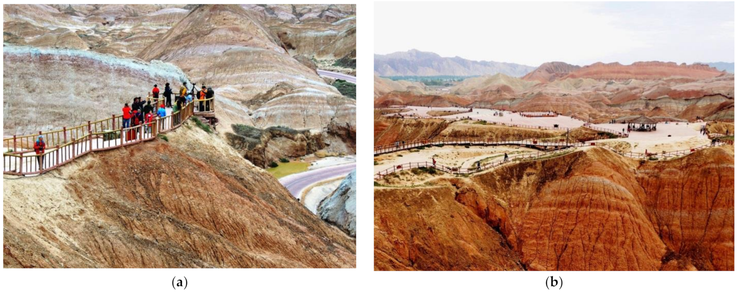
Geoparks are natural parks characterized by the presence of geological features of interest [2,3,4]. The management, preservation, and enhancement of the parks’ geological heritages follow the guidelines of the IUCN. With reference to this category, it is worth mentioning that many places of tourist attraction often have an important geological basis. In Italy, for example, the Cinque Terre, the Amalfi Coast, and the tuff villages in the Tuscia (northern Latium) can be mentioned. These are places where human activity has historically been able to adapt to the environment, achieving a balance based on the geomorphology of the territory and local stone types used for the construction of inhabited centres.
A park is thus a protected area recognised, regulated, and managed by an administration where, according to the IUCN, some activities are permitted, i.e., those existing de facto, those necessary for the management of the protected territory or those necessary for the balanced development of tourism, and recreational activities, in the area.
On the contrary, other human activities are to be excluded because they are incompatible with the collective public interest and purpose of conserving and enhancing the environmental asset. Unfortunately, the emergence of these parks, their official international recognition together with the increasing possibility of travelling, and the ease of the dissemination of news have favoured the emergence of new mass tourism. Tourists are attracted by the idea of an ecological and high-level holiday (i.e., UNESCO Geoparks) or even by the curiosity of visiting places that have been the sets of famous films.
This evolution from places for the few to places of mass tourism required a change in the management of the parks with interventions aimed to secure the sites and visiting routes. This, in many cases, resulted in the loss of the charm of the visit for those who wished to enjoy the sites in silence and contemplation. Road infrastructures and reception areas, necessarily built to avoid do-it-yourself attempts by visitors, try to blend in with the surroundings, inevitably altering their appearance and perception, and, in some cases, creating damage [5]. Moreover, economic objectives sometimes prevailed over social and ecological ones that led to the birth of the park [6].
The sustainability of park management has been investigated in numerous studies showing the conflicting tendency between tourism development and ecological protection, i.e., [7,8,9,10], and attempted to find solutions [11]. There is therefore a clear need for proper management of the tourist flow and an Environmental Impact Assessment (EIA) following this flow [12,13,14,15,16].
Some of the problems addressed concern how to handle the complexity of the territories, generate socioeconomic benefits for local populations, and resolve conflicts with local actors, a prerequisite for sustainable management [17,18].
As for the problem of overtourism and seasonal variations in tourism demand, possible mitigation has been envisaged by establishing different seasonal entrance fees capable of supporting demand during undertourism and generating a higher level of revenue for the park’s economic equilibrium [19]. The problem was also addressed by using social big data that can help managers to establish spatially explicit management policies that consider tourism pressures on individual protected areas [20] and SWOT analysis in the case of an Iranian park [21]. Still, in the context of mitigating the excessive number of tourists, transport services are being considered (including soft mobility and transport infrastructures [22]). Barrena Ruiz et al. [23] instead examined mobility within parks with the need to establish fixed-boundary conservation enclosures.
Another technology proposed for balancing the economic and environmental benefits of parks is three-dimensional sensor image acquisition in order to monitor tourists in the reserve and the collection of natural environment data. According to the collected data, it is possible to envisage an environment capacity assessment and pricing plan [24].
The examination of the motivations that drive tourists to visit parks and how these can be governed for sustainable fruition [25,26] is also of interest. On the other side, Xu and Fox [27] explored how different cultural contexts, namely from China and the UK, influence the attitude of a person visiting national parks. Other authors, in light of the increasing number of extreme weather events, have dealt with the revision of land use planning, retrofitting, and redesigning of some of the national park facilities and infrastructures to ensure climate resilience and sustainable tourism [28].
With regard to geoparks, many authors have pointed out that the transition to a UNESCO geopark can only take place with the involvement of local administrations and stakeholders [29,30,31,32]. Even in UNESCO geoparks, there is a strong conflict of interest between economic benefits and the preservation of the natural environment [33,34], and efforts are being made try to understand how the parameters of sustainability and quality required by the UNESCO network in terms of ecosystem protection and conservation can actually be measured [35,36].
Overall, a review of the existing literature indicates that in most cases where a park has been established, there has been a negative impact on the environment due to the increase in visitor numbers without adequate planning for their management. On the other hand, the presence of a park has certainly prevented land use that would have led to the destruction of existing natural heritage, and this is a positive aspect.
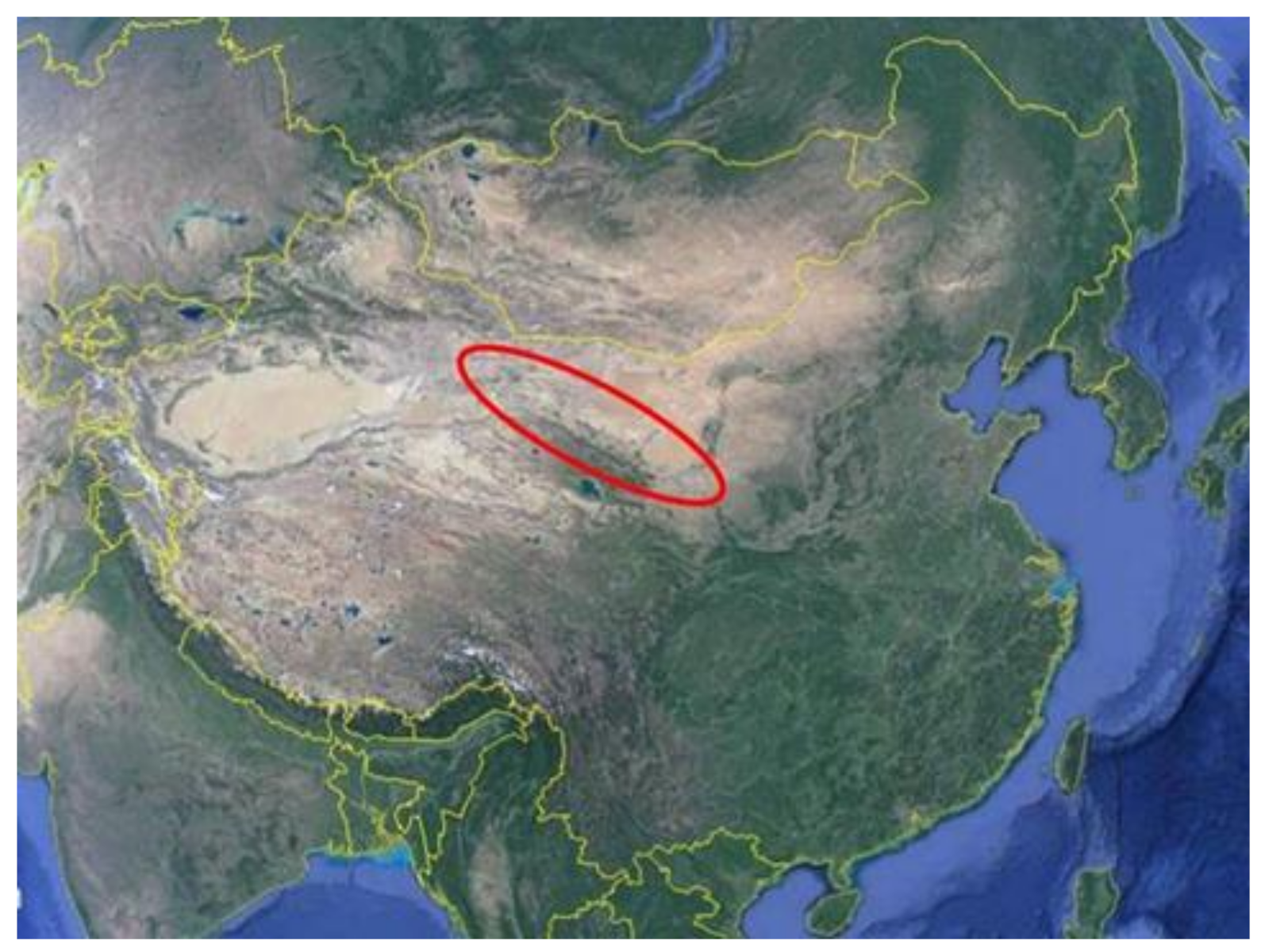
A recent trip to China made by the authors created awareness that the tourist development of parks and sites of geological interest has gained unexpected dimensions. This has engendered real bafflement.
Young Ng [37], as part of the Global Eco Asia–Pacific Conference held in Adelaide on 27–29 November 2017, examined the economic impact generated by tourism from the only category of geoparks in China. From the year 2000 to 2017 there was a total of 1.42 billion visitors with an annual increase of 5–7%. This has allowed the creation of jobs and business opportunities: enterprises in the field of infrastructure construction, the transport sector, catering, hospitality, manufacturing and production of souvenirs and local foods, museum design, and organization of events. Travel agencies were born and the presence of naturalistic guides, environmental guards, and conservation professionals (geologists, biologists, ecologists, etc.) was necessary.
The following numbers give an idea of the economic activity that was born: there are 23,000 hotels and agritourism centres, 20,500 directors and administrative staff, and 464,000 front-line personnel. As a result, 2.6 million jobs have been created. The income generated since the year 2000 is 90 billion dollars. On average, each geopark had an annual income of $26 million with the creation of 15,000 jobs, considering the related industries.
The business revolving around these parks is significant and is also very similar on other continents.
In the United States, the market behind natural park tourism has been estimated to be around 940 million dollars in 2022. As for Europe, since the prevailing policy is that of free access (i.e., not charging entrance fees to parks), it is not possible to monitor the number of visitors and, consequently, to correctly quantify the economic impact of this type of tourism [38].
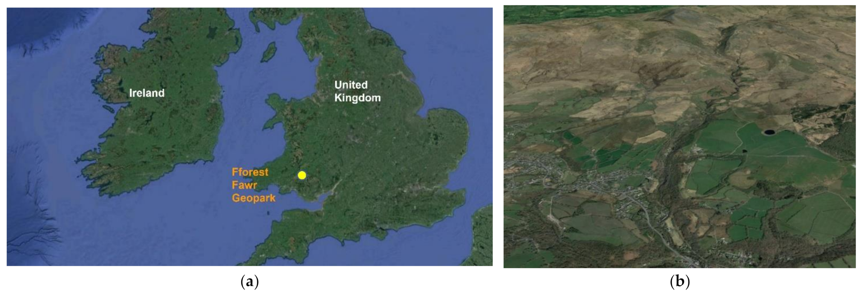
In the following, some examples of parks in China, the United States, and Europe will be examined with a focus on the infrastructures that are present and necessary for receiving tourists. Indeed, this aspect has been little investigated in the literature reviewed. As regards to the criterion for choosing the parks under this study, we compared parks in sparsely populated territories far from urbanised areas, such as in the United States and China, with European parks located in territories close to major communication networks and sometimes even the site of productive settlements, such as mining activities. This work is not meant to be an economic, urban planning, or social analysis but rather, considerations and questions arising from a particular sensitivity of persons who deal with cultural heritage, including landscape and natural heritage, regarding the real coexistence between park tourism and the very essence for which the parks were established.

2. Chinese Parks

The first National Forest Park in China was established in 1982 (Zhangjiajie National Forest Park). Since then, the number has increased rapidly, and by 2012, 1865 areas were classified as national parks according to IUCN Guidelines and the CPNAP [39]. In recent years (since 2015), China has invested heavily in the development of its national park system and regulation in order to recognize these parks in the prestigious networks of the Unesco Global Geoparks [37,40,41,42,43,44,45].

Two Examples of Chinese Parks

Two geoparks were visited, both located in the Gansu province along the Silk Road. These are the Yardang National Geopark and Zhangye Danxia Geopark (Figure 1).
The Yardang National Geopark is located about 180 km northwest of Dunhuang in a desert environment. It is characterized by the particular forms of erosion of yellowish sub-horizontal layers of sandstone rocks of the Tertiary age which gave rise to isolated monoliths arranged along parallel alignments that rise for about ten meters high on a stony surface (Figure 2a).
Further east, located on the northern slopes of the Qilian Mountains, 30 km from the city of Zhangye, is the Zhangye Danxia Geopark. There are two visiting areas: the scenic area of the Danxia of Linze (better known as “Coloured Mountains”) and the area located on the northern bank of the Liyuan River near Binggou (known as “Ice Gullies”). The first, the most visited, consists of a hilly landscape devoid of vegetation that is characterized by bright red, yellow, and whitish colours due to the alternation of easily erodible inclined layers of sandstone, argillite, and marls of the Tertiary age (Figure 2b). The second area is in a mountain environment and characterized by the presence of an arenaceous formation, also of Tertiary age, that is slightly stratified, reddish in colour, and strongly eroded to form a landscape of peaks and tabular forms that resemble towers and castles (Figure 2c).
Both sites are highly spectacular and deserving of conservation but arouse perplexities about the modalities related to their promotion/visit. For Yardang National Geopark, a road of more than 100 km (with a toll booth for a fee) was specially created and ends with a large parking area near the actual access to the geopark (Figure 3a) where a large visitor centre is located; it is architecturally well-designed in order to have the least visual impact on the landscape. The visitor centre is well-organized and, in addition to the commercial part, has an exhibition and multimedia area that effectively explains the genesis of the landscape that characterizes the geopark. The visitor centre gives access to a large square from where buses depart, taking the tourists along a few-kilometres-long road running in the middle of the desert until a rest area at the most spectacular point of the park (Figure 3b and Figure 4).
As for the Zhangye Danxia Geopark, the valley basin near the access to the panoramic area of the Danxia of Linze has been largely urbanized with the construction of a large village which hosts restaurants and hotels (Figure 5a,b), with large car parks, a large visitor centre/ticket office, and a museum, which is interesting from an architectural point of view (Figure 6a,b). The visitor centre gives access to a large square (there is the impression to get out of the railway station/airport) from where the buses take visitors inside the park along a specially built road stopping at various visiting points (Figure 7a,b). Each one of these stops branches off a network of pedestrian paths that rise and fall on the hills, allowing one to observe the landscape from the inside (Figure 8a). One is impressed by the large number of visitors who arrive in areas otherwise inaccessible thanks to the paths on the edge of the crests of the steep hills. In order to allow visits for people with reduced mobility, a large square was also created in an elevated area that can be reached by the same buses and cars (Figure 8b).
Regarding the visiting area near Binggou, at the access point, there is a commercial building with an adjoining ticket office of questionable appearance, in imitation of the arenaceous pinnacles that characterize the geopark. Moreover, in this case, it is possible to reach the visiting area by bus which can only be enjoyed thanks to daring pedestrian paths that run along steep slopes and on the ridges.
From what has been reported on these two geoparks, a substantial difference emerges between them because, in the case of Yardang Park, the new infrastructures are limited, even taking into account the smaller number of visitors, and have a minimal impact on the landscape. In the case of Zhangye Danxia Geopark, the infrastructures built for visits and accommodations have a considerable impact on the landscape, both in terms of extent and the way in which the park is made available to visitors. The only positive aspect is that the site has also been made accessible to the handicapped.

3. United States of America Parks

In the United States, the National Park System comprises 423 national park sites and covers over 84 million acres, with parks in every state and territory, including Puerto Rico, the Virgin Islands, American Samoa, and Guam. Within the system, there are 63 sites officially designated by Congress as “National Parks” (the Grand Canyon, Yellowstone, Redwood, etc.), i.e., protected areas managed by the National Park Service.
The following parks are described below, located in the American territory, as shown in Figure 9: Death Valley, Monument valley, Canyonland, and Yellowstone.

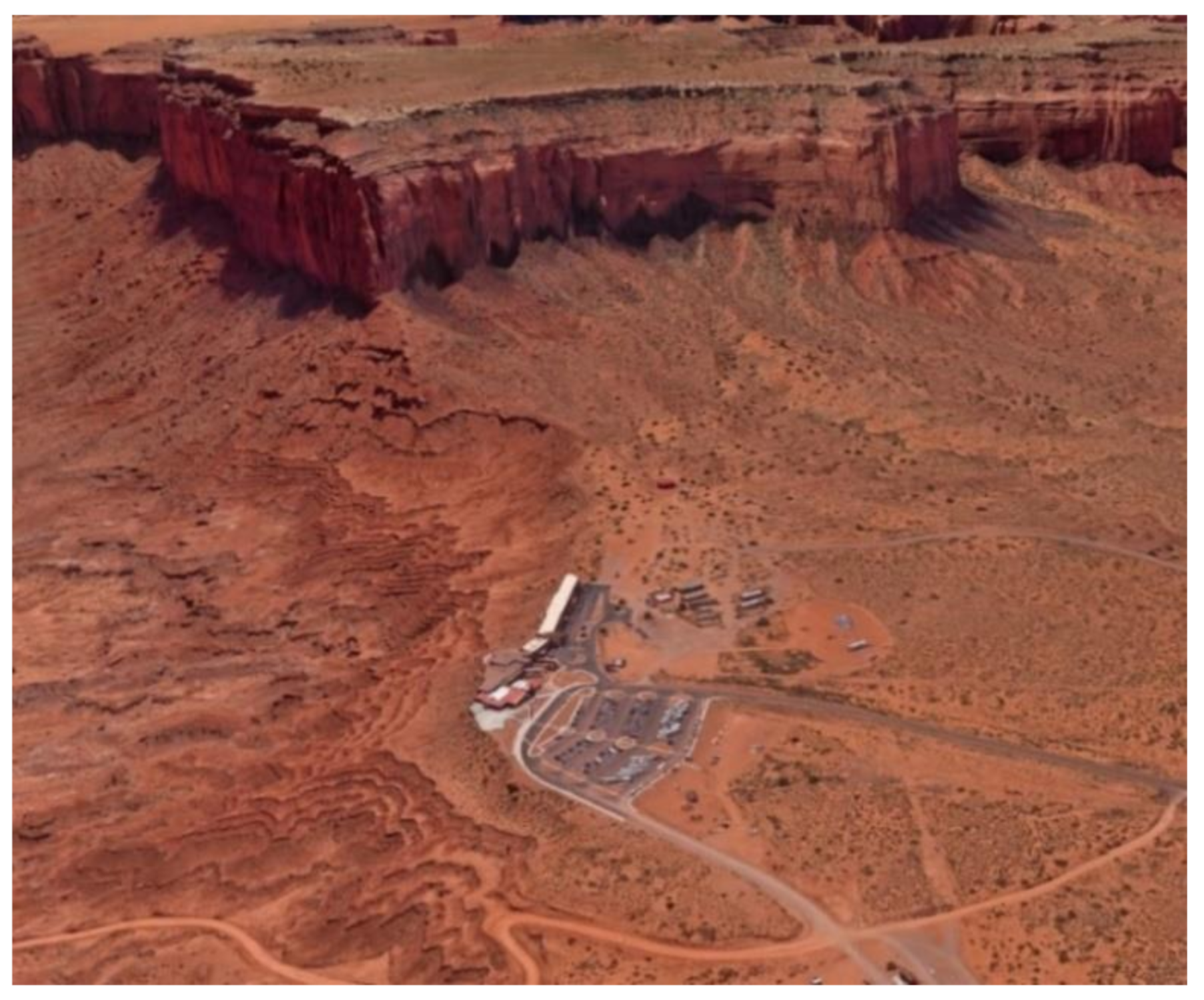
3.1. Monument Valley Navajo Tribal Park

Monument Valley is a Navajo Nation tribal park, straddling the border of northeastern Arizona and southeastern Utah of the Colorado Plateau. It preserves the Navajo way of life and some of the most striking and recognizable landscapes of sandstone buttes, mesas, and spires in the entire Southwest of the United States.
The area is entirely within the Navajo Indian Reservation near the small Indian town of Goulding, established in 1923 as a trading post, and now has a comprehensive range of visitor services. The landscape is characterized by an alternating series of high east-facing escarpments and wide west-facing plateaus, dissected by the deep canyons of the San Juan and Colorado Rivers and their tributaries. The elevation above sea level of most of the area averages 1500 m. The sedimentary formations range in age from Upper Carboniferous to Quaternary.
The oldest formation is found in the deep, narrow canyon of the San Juan River in the eastern part of the area, while progressively younger formations are exposed to the west in a succession of steep slopes, cliffs, and broad banks. Most of the formations are of continental origins, such as the Cedar Mesa and De Chelly sandstones of the Cutler Formations and the Wingate, Navajo and Entrada sandstones. Volcanic hills and basic igneous rock dykes of Tertiary age are present like in the Alhambra Rock, a jagged spire of igneous rock that, due to its black colour, contrasts strikingly with the red rocks of the surrounding country [48].

Visitor Centre, Accommodation, and Services

The main visitor centre is one mile east of US Highway 163 on the Arizona–Utah border. This centre has a big gift shop as well as various exhibits of the Navajo Nation, Navajo Code Talkers, and the area’s history. There is also a full-service restaurant for breakfast, lunch, and dinner outside the park in Goulding. As for accommodations, there is a luxury hotel inside the park, and other lodging is available near the entrance to the park. Another possible place to stay is at the campgrounds. The visitors’ centre, although built in such colours as to merge into its surroundings, is equipped with some leisure facilities and an athletics/football field, the need for which is not understood, considering that this is a place that should inspire quiet contemplation (Figure 10 and Figure 11).
The campgrounds, on the other hand, represent a way of experiencing the park closer to its essence, but of course, can be uncomfortable and therefore not usable by the elderly and people with disabilities.

3.2. Canyonlands National Park (Utah)

Canyonlands National Park is in southeastern Utah near the town of Moab. The park preserves a colourful landscape eroded into numerous canyons, mesas, and buttes by the Colorado River, the Green River, and their respective tributaries. Canyonlands is Utah’s largest national park with 1366 Km2 of land and water. The Green and Colorado Rivers split the park into three major districts: Island in the Sky, The Needles, and The Maze.
Island in the Sky, located in the north of the park, is about 40 min from Moab. The Needles district is in the southeast corner of Canyonlands, about 90 min from Moab or an hour from Monticello. The Maze district, located in the west of the park, is the most remote and challenging.
There are no roads within the park that cross the rivers to directly link any of Canyonlands’ districts. Travelling between them requires two to six hours by high-clearance 4WD.
For hundreds of millions of years, material from a variety of sources was deposited forming sedimentary rocks. Until about 15 million years ago, most of the canyon area was close to sea level. Local uplifts and volcanic activity created features such as the Waterpocket Fold at Capitol Reef and the La Sal Mountains near Moab, but then movements of the Earth’s crust raised the entire area. Today, the average elevation is 1500 m above sea level. The uplift of this region, known as the Colorado Plateau, marked the transition from a depositional to an erosional environment. The Colorado and Green Rivers began to descend and are now embedded in canyons over 600 m deep. Sediment-laden stormwater runs off into these rivers, transforming the surrounding landscape into a network of tributary canyons, culverts, and washes. A particular factor in shaping Canyonlands is the Paradox Formation, a layer of evaporite from the Upper Carboniferous. Buried deep within, the salts in this layer can liquefy under the weight of the overlying rock, flowing like toothpaste away from the source of greatest load. In response, the upper layers may rise, creating salt domes, or erode and collapse, creating salt valleys. This phenomenon is particularly visible in The Needles.

Visitor Centre, Accommodation, and Services

Each district of the park has its visitor centre or ranger station. Canyonlands is a remote area with few services. There is no food, lodging, or gas available in Canyonlands National Park.
There are campgrounds at Island in the Sky and The Needles. Island in the Sky Campground (Willow Flat) has 12 sites, first come, first served. The campground is open year-round. There are toilets, picnic tables, and fire rings at the campgrounds; there is no water. It is possible to get drinking water outside the visitor centre spring through fall. Sites fill quickly from spring through fall.
The Needles Campground has 26 individual sites plus 3 group sites in different locations around, with the possibility of reservation spring through fall. At other times of the year, individual sites are first come, first served. It is also possible to reserve group sites for nights between mid-March and mid-November. There are toilets, picnic tables, and fire rings.
Visitor centres are integrated into the landscape (apart from the roads) and are essential in the reception services (Figure 12 and Figure 13a). This park in its reception has favoured campgrounds instead of luxury hotels (Figure 13b).
Campgrounds are a sustainable solution from both a landscape and ecological point of view. They are integrated with the surrounding environment and enable guests to fully enjoy the landscape with a minimum of essential services and without leisure facilities (tennis courts, basketball courts, bars, etc.) whose presence is inappropriate.

3.3. Death Valley National Park (California/Nevada)

Death Valley is in southeastern California and, with 13,800 km2, is the largest national park in the United States outside Alaska. Death Valley is approximately 225 km long and 8 to 24 km wide. The valley is a graben bounded to the west by the Panamint Range and to the east by the Black, Funeral, and Grapevine mountains of the Amargosa Range. The present landscape was shaped between 35 million and 5 million years ago during the Cenozoic Era with the formation of the present graben filled by an enormous number of debris eroded from the surrounding mountains which range in thickness between 2500–3000 m. During the Ice Ages, Death Valley was periodically filled by large lakes. Their waves carved terraces out of the surrounding rocks, and their evaporation left alternating layers of mud and salt deposits that cover the present floor of the basin.

Visitor Centre, Accommodation, and Services

Almost 1600 km of paved and dirt roads provide access to both popular and remote locations. However, 93% of the park is protected by an officially designated wilderness reserve.
Furnace Creek Visitor Centre is the central hub for visiting Death Valley (Figure 14).
Here, there is a little airport without scheduled commercial flights, and it is possible to pay the park entrance fee, speak with a ranger about trip plans or questions, watch the 20 min park film, explore museum displays, and browse the park bookstore.
Driving distances between sightseeing and lodging can be long in the park. When picking a place to sleep, visitors should consider the location of the lodging and what parts of the park they want to visit. In the park, luxury accommodations are available.
Campsites are limited to no more than eight people and two vehicles. Larger groups wishing to camp together can reserve group sites at the Furnace Creek Campground.
As in the case of Monument Valley, luxury accommodation with leisure facilities such as tennis courts and swimming pools has been favoured in Death Valley Park (Figure 14 and Figure 15). Luxury tourism is thus favoured, which is obviously for those who want to have privileged treatment. Staying in these places is a means of affirming one’s social status rather than a way to get to know and appreciate landscapes and nature. Moreover, this luxury accommodation certainly results in high consumption of resources (water, electricity, etc.).

3.4. Yellowstone National Park (Wyoming/Montana/Idaho)

Yellowstone National Park, founded on 1 March 1872 by President Ulysses S. Grant, is the oldest national park in the world and covers 8983.18 km². It has been a UNESCO World Heritage Site since 1978 and straddles three states, northwestern Wyoming (for the most part), southeastern Idaho, and southwestern Montana. The park is known for its diverse wildlife and numerous geothermal manifestations.
Violent geological forces have created Yellowstone National Park’s physical landscape. Here, active volcanic systems and geothermal phenomena make this national park a priceless treasure. In fact, Yellowstone was established as the world’s first national park primarily because of its extraordinary geysers, hot springs, mud pots and steam vents, and other wonders such as the Grand Canyon of the Yellowstone River.
Until the end of the Mesozoic, the Yellowstone terrain was a combination of shallow oceans, sand dunes, and extensive plains. Starting about 30 million years ago, the plates of western North America began to separate from Europe. As the movement of the plates accelerated about 17 million years ago, volcanic activity at the hot spot also increased. As the Earth’s crust passed over this magma chamber, dozens of volcanic eruptions occurred. The plate moved in a south–west direction, leaving a landscape marked by more than 100 volcanic calderas created during the 800 km journey to present-day Yellowstone. Then, about 2.1 million years ago, the first massive eruption occurred that devastated present-day Yellowstone. The last big eruption occurred about 640,000 years ago, leaving behind an enormous caldera measuring roughly 50 by 70 km. The last-known lava flowed in Yellowstone about 70,000 years ago.

Visitor Centres, Accommodation, and Services

Many visitor centres are present in the park like Old Faithful Visitor and Education Centre, Fishing Bridge, Grant Visitor Centre, West Yellowstone, and Canyon Visitor Education Centre. Accommodations are provided by nine lodges, twelve campsites, and hundreds of backcountry campsites. Moreover, restaurants and cafes can be found near the lodges as well as general shops for those who wish to purchase groceries or snacks. In addition, there are 52 picnic areas scattered throughout the park.
Yellowstone is the oldest park in the world and is rich in naturalistic, geological, and geothermal features that are not only of scientific interest but are undoubtedly spectacular. This resulted in the development of many visitor centres, visitor facilities, and infrastructures for mobility and parking (Figure 16a,b).
The impact on the environment has been important since these infrastructures have often not integrated with the natural landscape. As justification, it can be assumed that it was a necessary ‘damage’ to avoid greater ‘damage’ due to DIY solutions by tourists.

4. European Parks

In Europe, as reported by the Europarc Federation (the network for Europe’s natural and cultural heritage), there are almost 900 nature, regional, and landscape parks in 22 European countries. They cover about 8% of the total area of the EU-28, together with Norway and Switzerland [49].
The following parks are described below, located in the European territory: Molina-Alto Tajo (Spain), Swabian Alb (Germany), FforestFawr (United Kingdom), and Adamello Brenta (Italy).

4.1. Molina-Alto Tajo Geopark (Spain)

The Molina-Alto Tajo Geopark is located in the Iberian Mountain range between the basins of the Ebro River to the north and the Tagus River to the south, belonging to the eastern part of the province of Guadalajara (Figure 17a). With an extension of 4000 km2, it consists of a plateau with an average altitude of approximately 1100 m above sea level. This area shows continuous sedimentary sequences spanning the last 400 million years from the Upper Ordovician to the Lower Jurassic. Five geosites are located within the territory of the Geopark: the Fuentelsaz stratigraphic section; the Barranco de la Hoz stratigraphic section; the Graptolite outcrop in Checa; the Permian fossil trees in the Sierra de Aragoncillo mountains; and the Lower Silurian Dropstone in Checa. The Tajo River canyon, which crosses the geopark from east to west, constitutes its geographical axis, forming the densest network of river canyons in the Iberian Peninsula. However, this territory is also distinguished by its geomorphological diversity: there are examples of karstic formations (tufa constructions of the San Pedro Bridge and El Campillo), the limestone pavement of the Hoya del Espino and periglacial formations, with magnificent examples of blocky rivers in the Orea Mountains. There are also several Sites of Community Interest (SCI) included in the Natura 2000 network, such as the heaths of Maranchón, the ravines of Mesa and Aragoncillo, the mountains of Picaza, and the juniper forest of Alustante-Tordesilos [49].

Visitor Centres, Accommodation, and Services

There are no real visitor centres, but information points located in the park and in existing villages where accommodation can also be found (Figure 17b).
The fruition of the park takes place by using accommodations consisting of existing buildings inside the old villages, therefore, without affecting the consumption of land and the perception of the landscape.

4.2. Swabian Alb Geopark (Germany)

The Swabian Alb Geopark is one of the oldest Geoparks in Germany. The Swabian Alb forms the central part of the Jura chain stretching across southwest Germany for a length of about 220 km and a width of up to 80 km (Figure 18a). The geopark covers 6800 km2 and has an extraordinarily rich natural and cultural heritage with more than 2000 caves and fossil sites of unique scientific value. Thanks to this exceptional geological heritage and its optimal location in relation to nearby towns (Stuttgart, Munich), the geopark has become an important tourist attraction in Europe [50].
The mountain chain is mainly constituted by black-brown and white Jurassic deposits. As a result of the tectonic swelling of the Jurassic plate and regressive erosion during the Cretaceous period, a steep escarpment formed the upper layer of the landscape of the southwest German cuesta. The predominant presence of limestone rocks makes the southeast-facing Jura Plateau the largest karst region in central Europe. Thus, karst morphologies dominate the landscape, and there is the highest concentration of karst caves in Europe.
The Swabian Alb offers geological, palaeontological, and archaeological features of worldwide significance, such as the two meteorite craters, the fossil sites of Holzmaden, Dotternhausen, and Nusplingen, or the Aalenium and Pliensbachium type localities, named after Swabian Alb localities.

Visitor Centres, Accommodation, and Services

The geopark information centres are in the villages and towns present in the park where it is also possible to find accommodations (Figure 18b). Each one of them gives different information concerning the various geological eras, the bizarre cave world of the Alb, the meteorite crater, or the footsteps of Stone Age man. The fruition of the park takes place by using accommodations consisting of existing buildings inside the old villages, therefore, without affecting the consumption of land and the perception of the landscape.

4.3. FforestFawr Geopark (United Kingdom)

The FforestFawr Geopark is sited in the western half of the Brecon Beacons National Park in South Wales (Figure 19a). The current area covers 500 km2 and was recognised by UNESCO in December 2015. The centre is the mountain massifs of FforestFawr, Black Mountain, and the central Brecon Beacons.
In various parts of the geopark, rock outcrops from the Ordovician to Carboniferous periods are present. Many of the Ordovician and Silurian sandstones and mudstones were faulted and tightly folded during the Caledonian Orogeny. The Devonian and Carboniferous sandstones, mudstones, and limestones were generally gently tilted to the south and southwest towards the main South Wales coalfield. The area was subjected to repeated glaciation during the Quaternary period and therefore moraines and glacial lakes can be seen at the foot of the north face of Black Mountain, particularly at Llyn y Fan Fach and Llyn y Fan Fawr, below the peaks of Picws Du and Fan Foel [32].
The karst formations are characteristic of the limestone belt running east–west through FforestFawr Geopark and include some of the most extensive cave networks in Britain and many sinkholes.
The Old Red Sandstone (ORS) forms the main peaks that have been attracting hikers for decades. The Carboniferous limestone forms an east–west belt south of the ORS that is home to some of the longest and deepest cave networks in the country, such as Ogof Ffynnon Ddu and the impressive Porth yr Ogof, into which the Afon Mellte flows. Further to the south is the Millstone Grit landscape, the most visited part of which is Waterfall Country, which boasts the finest collection of waterfalls in the UK.

Visitor Centres, Accommodation, and Services

Many tourist information centres, national park information centres, and village information points are present in the park. Concerning accommodations, there is a wide choice including grand country hotels, comfortable guesthouses, and cosy inns and, elegant B&Bs tucked away in the hills (Figure 19b). For those who want to be more independent, there are self-catering cottages, bunkhouses, hostels, friendly glamping sites, campsites, caravan sites, and even canal boats. As a bonus, more and more accommodation businesses in the Brecon Beacons are gaining the officially approved Green Tourism Business Scheme standard. The fruition of the park takes place by using accommodation consisting of existing buildings inside the old villages, therefore, without affecting the consumption of land and the perception of the landscape.

4.4. Adamello Brenta Geopark Park (Italy)

The Adamello Brenta Nature Park is a nature reserve located in the western part of the Province of Trento in northeastern Italy (Figure 20a). Established in 1967, it covers an area of 1146 km2, including the strictly protected area and the administrative territory of 38 municipalities in whose territory the Natural Park is located. It has been a UNESCO Global Geopark since 2008, and its core consists of the Trentino portion of the Adamello-Presanella Plutonic chain and the entire Brenta Dolomites chain. The geological, geomorphological, and naturalistic highlights of the Geopark are the following:
  • the presence of tectonic boundaries between the Austrian Alps and the Southern Alps and the intersection of three structural segments of the Periadriatic Lineament;
  • the presence of geological units in the park’s territory and surrounding areas testifying to a long and complex geological evolution that began in the Lower Palaeozoic Era until the Quaternary;
  • the great glaciers of the Adamello massif and the astonishing landscape of the Brenta Dolomites with its pinnacles and dizzyingly high dolomite peaks;
  • the impressive glacial and periglacial evidence modelled in the plutonic rock of the Adamello that bears witness to the Last Glacial Maximum and the Little Ice Age;
  • marvellous hypogean and epigean karst features characterise the carbonate massif of the Brenta Dolomites.
Figure 20. (a) The Adamello Brenta Park in the Italian territory (from Google Earth Pro V 7.3.4, (14 December 2015), 46°15′46.09″ N, 10°36′00.94″ E, Eye alt 1284.59 km, Terrametrics, SIO, NOAA, US Navy, NGA, GEBCO, Landsat, Copernicus 2022, GeoBasis-DE/BKG 2009, [46], modified); (b) the small villages at the foot of the Brenta Dolomites belonging to Adamello Brenta Geopark Park (from Google Earth Pro V 7.3.4, (19 July 2021), 46°04′33.78″ N, 10°54′34.60″ E, Eye alt 2.31 km, Maxar Technologies, Landsat, Copernicus, CNES, Airbus 2022, [46]).
Geosciences 12 00430 g020

Visitor Centres, Accommodation, and Services

Tourist information centres are present in the villages surrounding and inside the park. Concerning accommodations, there is a wide choice of tourist accommodations in the villages themselves, which are also winter tourism resorts (Figure 20b).

5. Discussion

The business revolving around natural parks has been growing remarkably in recent decades in China, the United States, and Europe. Nevertheless, together with the economic benefits, serious shortcomings in the planning of the construction of reception facilities and road infrastructures (required for this new type of tourism) are highlighted because of damages to the natural environment and the landscape.
The analyses carried out on a few Chinese, American, and European cases highlight a different approach to tourist reception in the old continent. This situation is essentially linked to the fact that European parks, compared to the American and Chinese ones, are generally smaller in size and located in places less than two hours away by car from major cities. Furthermore, European parks are located in inhabited areas that are interested in economic activities, such as agriculture, animal farming, or past activities, related to the exploitation of geomineral resources. Thanks to this, the European parks have not undergone major interventions to increase the road network and reception facilities, but the administrations have made every effort to promote the use of public transport and the internal network of ancient paths to visit the parks from the reception centres and also to encourage the dispersal of the flow of tourists in small towns. Moreover, in Europe, tourism related to natural parks is not comparable in terms of the number of visitors with that of the US and China.
In China, the flow of tourists is concentrated during the high season, resulting in crowding. This large flow of tourists not only puts pressure on reception but also destroys the original ecological environment. The need to build infrastructure, roads, fences, etc. is therefore essential for the protection of the geological heritage and the environment. Nevertheless, natural parks with fragile ecological conditions and limited tourism capacities find it more difficult to build and maintain the necessary infrastructures to support the flux of tourists that causes crowding in the high season. Imposing a limit on the number of tourists could be beneficial for the protection of the park.
The Huangshan Geopark adjusts its tourist threshold according to weather conditions, and when the maximum limit is reached, the system either stops selling tickets or encourages visitors who have purchased tickets to visit the park the next day. Unfortunately for some parks, the income from tourism seems to be the sole purpose of the park’s existence, neglecting the protection and conservation of the natural heritage [5,42,51].
Even in the United States, with an estimated turnover in 2022 of USD 940 million, nature parks are a considerable source of revenue. Therefore, the question arises as to whether economic profit bypasses the protection of the wilderness or whether it is precisely for the protection of the sites that solutions not “environmentally sustainable” are sometimes accepted. In this regard, it is interesting the sentence written about Yellowstone Park on the official national park system:
“Some alterations to the landscape, such as the construction of roads and other structures, are generally accepted as necessary to meet the needs of today’s visitors”.
[52]
Therefore, there is an awareness of the environmental impact of some visitor infrastructures (tourist facilities themselves, roads, employee accommodation, car parks, service areas, and waste disposal), but there is probably also a lack of planning and building regulations [53].
Thus, in many American destinations, accommodation facilities have developed along coastlines, valleys, and scenic roads consisting of large resorts of heterogeneous design that are out of place with the natural environment and clash with the indigenous structural design [54]. One wonders, however, what sense there is in building tennis and athletics courts and swimming pools, and how their construction was authorised in these places where one should go to contemplate and experience.
In light of what has occurred, the question is about the cost/benefit ratio with respect to the initial motivation of protecting the natural environment that led to the creation of these parks. Should tourism be banned in these areas? Which actions can be taken? Certainly, there are some situations that cannot be changed due to a general system, e.g., holidays are concentrated for most of the countries in the same period and to the geographic position (i.e., some parks cannot be visited in winter for the severe climatic conditions).
In cities of art, an attempt is made to propose alternative routes and itineraries to the usual ones in order to avoid an excess of tourists, especially in small cities of medieval origin. Likewise, for small parks located in places difficult to reach and at risk to collapse during the peak flow period, solutions should be found for sustainable fruition.
Is it acceptable for those who base their new economy on the existence of a natural park to give up part of their income? Which commission should oversee the quality of the park?
As a matter of fact, the problem is not tourism itself but the capability of the management of the parks, whose mission should first be the protection of the sites and to govern the great number of tourists. Taking into account this difficulty and the consequent risk of lack of protection, the coexistence of tourism infrastructure and places of natural value is a difficult task and really problematic.
It is desirable to implement strategies and actions that teach tourists to respect the park by trying to stimulate a sense of belonging to the natural environment.
The damages that have been done by the construction of many incongruous infrastructures remain (unless they are destroyed), but future choices must be directed to make park management fully sustainable in all aspects. For this purpose, it would be sufficient to apply the IUCN principles. In 1993, the Europarc Federation published the ground-breaking report “Loving them to death”, which called for sustainable tourism in Europe’s protected areas. Furthermore, in 1995, the Europarc Federation took the initiative to establish the European Charter for Sustainable Tourism in Protected Areas.
This charter is a practical management tool in which the central element is the collaboration among all the stakeholders to develop a common sustainable tourism strategy and action plan based on a thorough analysis of the situation. The objective of all Charter projects and activities is the protection of the natural and cultural heritage together with an improvement of tourism. Parks that complete the Charter process ensure that effective and suitable management allows a sustainable and cost-effective enjoyment of parks! But how many parks meet the demands of the charter? Is this charter used?
Tourism, on the other hand, can directly contribute to the conservation of sensitive areas and habitats through the revenue from park entrance fees. These funds can be used for general conservation programmes and activities, such as park ranger salaries and park maintenance.
Planning tourism development and thus the tourism-related facilities (particularly accommodations) could prevent harmful and costly mistakes such as the gradual deterioration of the environmental assets [42,55].

6. Conclusions

The big business revolving around parks has been growing in recent decades in China, the United States, and Europe. However, while this has brought economic benefits, it has also highlighted shortcomings in the planning of reception facilities and road infrastructure needed for this new type of tourism, causing damage to the natural environment and the landscape. The American and Chinese reception models resemble each other in terms of similar park characteristics, size, and location. The European ones seem more virtuous because their location is more favourable to the use of existing structures for both accommodation and travel.
Regarding the title of this article “Can tourism and natural parks coexist?”, this coexistence is a hard challenge. In fact, when man arrives in a new environment, he inevitably changes it and even more in the presence of large numbers of people. What can be done is to limit the damage by governing the number of visitors (i.e., promoting visits to the parks in low season and diversifying the tourist offer also towards less attractive or well-known places), reduce the infrastructure and visitor centres, promote the use of local transport, and educate tourists to respect the nature and the rules of the park.
In this sense, the European parks have an advantage with respect to American and Chinese parks because they were established in territories where man had already modified the environment with settlements and economic activities mainly in balance with the environment itself. Nevertheless, the greatest wish would be to return the charm of discovering places in meditation and silence, emotions that have unfortunately been completely lost with this type of tourism. However, perhaps that is the price that has to be paid for the preservation of places!
This research opens the way for further investigation, particularly in the context of European parks, in order to study the relationship between the traditional buildings present in the parks and the natural resources/raw materials that characterise them, all aimed at enhancing them for visitors who will thus be able to understand how each territory and human presence have interacted in shaping the landscape.

Author Contributions

All authors namely F.F., S.R. and L.L. are to be considered principal authors because they contributed to the Conceptualisation, Writing—review & editing, Writing—original draft. All authors have read and agreed to the published version of the manuscript.

Funding

This research received no external funding.

Institutional Review Board Statement

Not applicable.

Informed Consent Statement

Not applicable.

Data Availability Statement

The data presented in this study are available in the References reported at the end of this paper.

Conflicts of Interest

The authors declare no conflict of interest.

References

  1. Commission on National Parks and Protected Areas and World Conservation Monitoring Centre. Guidelines for Protected Area Management Categories; The World Conservation Union: Cambridge, UK, 1994; p. 261. [Google Scholar]
  2. Eder, F.W. UNESCO Geoparks: A new initiative for protection and sustainable development of the earth heritage. Neues Jahrb. Für Geol. Paläontologie Abh. 1999, 214, 353–358. [Google Scholar] [CrossRef]
  3. Eder, F.W.; Patzak, M. Geoparks—Geological attractions: A tool for public education, recreation and sustainable economic development. Episodes 2004, 25, 162–164. [Google Scholar] [CrossRef] [Green Version]
  4. UNESCO. Operational Guidelines for the Implementation of the World Heritage Convention. In Intergovernmental Committee for the Protection of the World Cultural and Natural Heritage; UNESCO World Heritage Centre: Paris, France, 2008; p. 163. [Google Scholar]
  5. Holling, C.S. Understanding the Complexity of Economic, Ecological, and Social Systems. Ecosystems 2001, 4, 390–405. [Google Scholar] [CrossRef]
  6. Rollins, R.; Robinson, D. Social science, conservation, and protected areas. In Parks and Protected areas in Canada: Planning and Management, 2nd ed.; Dearden, P., Rollins, R., Eds.; Oxford University Press: Don Mills, UK, 2002; pp. 117–147. [Google Scholar]
  7. Canteiro, M.; Córdova-Tapia, F.; Brazeiro, A. Tourism impact assessment: A tool to evaluate the environmental impacts of touristic activities in Natural Protected Areas. Tour. Manag. Perspect. 2018, 28, 220–227. [Google Scholar] [CrossRef]
  8. Zeng, Y.; Zhong, L.; Wang, L.; Yu, H. Measuring the conflict tendency between tourism development and ecological protection in protected areas: A study on National Nature Reserves in China. Appl. Geogr. 2022, 142, 102690. [Google Scholar] [CrossRef]
  9. Baral, R.; Rijal, D.P. Visitors’ impacts on remote destinations: An evaluation of a Nepalese mountainous village with intense tourism activity. Heliyon 2022, 8, e10395. [Google Scholar] [CrossRef] [PubMed]
  10. Zhang, X.; Zhong, L.; Yu, H. Sustainability assessment of tourism in protected areas: A relational perspective. Glob. Ecol. Conserv. 2022, 35, e02074. [Google Scholar] [CrossRef]
  11. Demeter, C.; Fechner, D.; Dolnicar, S. Progress in field experimentation for environmentally sustainable tourism—A knowledge map and research agenda. Tour. Manag. 2023, 94, 104633. [Google Scholar] [CrossRef]
  12. Zheng, L.; Wang, Y.; Li, J. How to achieve the ecological sustainability goal of UNESCO Global Geoparks? A multi-scenario simulation and ecological assessment approach using Dabieshan UGGp, China as a case study. J. Clean. Prod. 2021, 329, 129779. [Google Scholar] [CrossRef]
  13. Dong, H.; Song, Y.; Chen, T.; Zhao, J.; Yu, L. Geoconservation and geotourism in Luochuan Loess National Geopark, China. Quat. Int. 2014, 334–335, 40–51. [Google Scholar] [CrossRef]
  14. Shi, Q. The impact of tourism on soils in Zhangjiajie World Geopark. J. For. Res. 2006, 17, 167–170. [Google Scholar] [CrossRef]
  15. Guo, W.; Chung, S. Using Tourism Carrying Capacity to Strengthen UNESCO Global Geopark Management in Hong Kong. Geoheritage 2019, 11, 193–205. [Google Scholar] [CrossRef]
  16. Pope, J.; Wessels, J.A.; Douglas, A.; Hughes, M.; Morrison-Saunders, A. The potential contribution of environmental impact assessment (EIA) to responsible tourism: The case of the Kruger national Park. Tour. Manag. Perspect. 2019, 32, 100557. [Google Scholar] [CrossRef]
  17. D’Arco, M.; Lo Presti, L.; Marino, V.; Maggiore, G. Is sustainable tourism a goal that came true? The Italian experience of the Cilento and Vallo di Diano National Park. Land Use Policy 2021, 101, 105198. [Google Scholar] [CrossRef]
  18. Burbano, D.V.; Valdivieso, J.C.; Izurieta, J.C.; Meredith, T.C.; Ferri, D.Q. “Rethink and reset” tourism in the Galapagos Islands: Stakeholders’ views on the sustainability of tourism development. Ann. Tour. Res. Empir. Insights 2022, 3, 100057. [Google Scholar] [CrossRef]
  19. Platania, M.; Sharpley, R.A.J.; Rizzo, M.; Ruggieri, G. The contingent equilibrium during imbalanced volcano tourism demand through fee estimation: An empirical analysis of tourism in Mount Etna. J. Environ. Manag. 2022, 316, 115235. [Google Scholar] [CrossRef]
  20. Chun, J.; Kim, C.K.; Kim, G.S.; Jeong, J.Y.; Lee, W.K. Social big data informs spatially explicit management options for national parks with high tourism pressures. Tour. Manag. 2020, 81, 104136. [Google Scholar] [CrossRef]
  21. Reihanian, A.; Binti Mahmood, N.Z.; Kahrom, E.; Hin, T.W. Sustainable tourism development strategy by SWOT analysis: Boujagh National Park, Iran. Tour. Manag. Perspect. 2012, 4, 223–228. [Google Scholar] [CrossRef]
  22. Buongiorno, A.; Intini, M. Sustainable tourism and mobility development in natural protected areas: Evidence from Apulia. Land Use Policy 2021, 101, 105220. [Google Scholar] [CrossRef]
  23. Ruiz, J.B.; Machiel Lamers, M.; Bush, S.; Wells, G.B. Governing nature-based tourism mobility in National Park Torres del Paine, Chilean Southern Patagonia. Mobilities 2019, 14, 745–761. [Google Scholar] [CrossRef]
  24. Zhang, Y.; Yang, H.; Wang, G. Monitoring and management of high-end tourism in protected areas based on 3D sensor image collection. Displays 2021, 70, 102089. [Google Scholar] [CrossRef]
  25. Carvache-Franco, M.; Segarra-Oña, M.; Carrascosa-López, C. Segmentation and motivations in eco-tourism: The case of a coastal national park. Ocean Coast. Manag. 2019, 178, 104812. [Google Scholar] [CrossRef]
  26. Trelohan, M.; François-Lecompte, A.; Gentric, M. Tourism development or nature protection? Lessons from a cluster analysis based on users of a French nature-based destination. J. Outdoor Recreat. Tour. 2022, 39, 100496. [Google Scholar] [CrossRef]
  27. Xu, F.; Fox, D. Modelling attitudes to nature, tourism and sustainable development in national parks: A survey of visitors in China and the UK. Tour. Manag. 2014, 45, 142–158. [Google Scholar] [CrossRef] [Green Version]
  28. Dube, K.; Nhamo, G. Evidence and impact of climate change on South African national parks. Potential Implic. Tour. Kruger Natl. Park. Environ. Dev. 2020, 33, 100485. [Google Scholar] [CrossRef]
  29. Wójtowicz, B.; Strachowka, R.; Strzyz, M. The perspectives of the development of tourism in the areas of geoparks in Poland. Procedia Soc. Behav. Sci. 2011, 19, 150–157. [Google Scholar] [CrossRef] [Green Version]
  30. Briggs, A.; Newsome, D.; Dowling, R. A proposed governance model for the adoption of geoparks in Australia. Int. J. Geoheritage Park. 2022, 10, 160–172. [Google Scholar] [CrossRef]
  31. Ríos, C.A.; Amorocho, R.; Villarreal, C.A.; Mantilla, W.; Velandia, F.A.; Castellanos, O.M.; Muñoz, S.I.; Atuesta, D.A.; Jerez, J.H.; Acevedo, O.; et al. Chicamocha Canyon Geopark project: A novel strategy for the socio-economic development of Santander (Colombia) through geoeducation, geotourism and geoconservation. Int. J. Geoheritage Park. 2020, 8, 96–122. [Google Scholar] [CrossRef]
  32. Ramsay, T. FforestFawr Geopark—A UNESCO Global Geopark distinguished by its geological, industrial and cultural heritage. Proc. Geol. Assoc. 2017, 128, 500–509. [Google Scholar] [CrossRef]
  33. Wang, Y.; Wu, F.; Li, X.; Chen, L. Geotourism, geoconservation, and geodiversity along the belt and road: A case study of Dunhuang UNESCO Global Geopark in China. Proc. Geol. Assoc. 2019, 130, 232–241. [Google Scholar] [CrossRef]
  34. Van Geert, F. The uses and challenges of the geopark label as a place branding tool. The case of the Geopark of the Tremp Basin-Montsec (Catalonia-Spain). Int. J. Geoheritage Park. 2019, 7, 72–84. [Google Scholar] [CrossRef]
  35. Fauzi, N.S.M.; Misni, A. Geoheritage Conservation: Indicators Affecting the Condition and Sustainability of Geopark—A Conceptual Review. Procedia Soc. Behav. Sci. 2016, 222, 676–684. [Google Scholar] [CrossRef] [Green Version]
  36. Pásková, M. Geopark Certification as an Efficient Form of Sustainable Management of a Geotourism Destination. In Economics and Management of Geotourism; Braga, V., Duarte, A., Marques, C.S., Eds.; Tourism, Hospitality & Event Management; Springer: Cham, Switzerland, 2022. [Google Scholar] [CrossRef]
  37. Young Ng, M.H. Economic impacts of geoturism and geoparks in China. In Proceedings of the Global Eco Asia-Pacific Conference, Adelaide, Australia, 27–29 November 2017. [Google Scholar]
  38. Mayer, M.; Job, H. The economics of protected areas—A European perspective. Z. Für Wirtsch. Geogr. 2014, 58, 73–97. [Google Scholar] [CrossRef] [Green Version]
  39. Wang, J.-H.Z. National parks in China: Parks for people or for the nation? Land Use Policy 2019, 81, 825–833. [Google Scholar] [CrossRef]
  40. Wang, G.; Innes, J.L.; Wu, S.W.; Krzyzanowski, J.; Yin, Y.; Dai, S.; Zhang, X.; Liu, S. National park development in China: Conservation or commercialisation? Ambio 2012, 41, 247–261. [Google Scholar] [CrossRef] [Green Version]
  41. Leman, M.S.; Reedman, A.; Pei, C.S. Geoheritage of East and Southeast Asia; Lestari Universiti Kibangsaan, Ampang Press: Kuala Lumpur, Malaysia, 2008; p. 308. [Google Scholar]
  42. Tang, X. The establishment of national park system: A new milestone for the field of nature conservation in China. Int. J. Geoheritage Park. 2020, 8, 195–202. [Google Scholar] [CrossRef]
  43. Yang, G.; Chen, Z.; Tian, M.; Wu, F.; Wray, R.A.L.; Ping, Y. On the growth of National geoparks in China: Distribution, interpretation, and regional comparison. Episodes 2011, 34, 157–176. [Google Scholar] [CrossRef] [Green Version]
  44. Pan, J. World Culture and Nature Heritage of China; Geological Publishing House: Beijing, China, 1995; pp. 88–125. [Google Scholar]
  45. Zhao, X.; Zhao, T. Geological background of National geoparks of China and construction of world geoparks. Geol. Bull. China 2003, 22, 620–630. [Google Scholar]
  46. Available online: https://earth.google.com (accessed on 2 September 2022).
  47. Available online: https://www.google.com/maps (accessed on 2 September 2022).
  48. Baker, A.A. Geology of the Monument Valley-Navajo Mountain Region, San Juan County, Utah; US Government Printing Office: Washington, DC, USA, 1936; Volume 865. [CrossRef]
  49. Available online: https://www.europarc.org/library/previous-projects/europes-nature-regional-landscape-parks/book-living-landscapes (accessed on 2 September 2022).
  50. Canesin, T.S.; Brilha, J.; Díaz-Martínez, E. Best Practices and Constraints in Geopark Management: Comparative Analysis of Two Spanish UNESCO Global Geoparks. Geoheritage 2020, 12, 14. [Google Scholar] [CrossRef]
  51. Megerle, H.E.; Pietsch, D. Consequences of overlapping territories between large scale protection areas and Geoparks in Germany: Opportunities and risks for geoheritage and geotourism. Ann. Géographie 2017, 717, 598–624. [Google Scholar] [CrossRef]
  52. Cai, Y.; Wu, F.; Watanabe, M.; Han, J. Characteristics of Geoparks in China and Japan: Similarities and Differences. Geoheritage 2021, 13, 101. [Google Scholar] [CrossRef]
  53. Available online: https://www.nps.gov/yell/learn/historyculture/park-history.htm (accessed on 2 September 2022).
  54. Finnessey, L. The Negative Effects of Tourism on National Parks in the United States. Honors Thesis, Johnson & Wales University, Providence, RI, USA, April 2021. Available online: https://scholarsarchive.jwu.edu/student_scholarship/4 (accessed on 2 September 2022).
  55. Sunlu, U. Environmental impacts of tourism. In Local Resources and Global Trade: Environment and Agriculture in the Mediterranean Region; Camarda, D., Grassini, L., Eds.; CIHEAM-IAMB: Valenzano, Italy, 2003; pp. 263–270. [Google Scholar]
Figure 1. Gansu province in China (from Google Earth Pro V 7.3.4 (14 December 2015), 38°30′38.59″ N, 99°34′03.75″ E, Eye alt 7432.84 km, Landsat, Copernicus, SIO, NOAA, US Navy, NGA, GEBCO 2022, [46], modified).
Geosciences 12 00430 g001
Figure 2. (a) Yardang National Geopark (credit Fabio Fratini); (b) the Coloured Mountains in the Zhangye Danxia Geopark (credit Fabio Fratini); (c) the landscape of the Ice Gullies with peaks and tabular forms (credit Loredana Luvidi).
Geosciences 12 00430 g002
Figure 3. (a) Visitor centre/ticket office of the Yardang National Geopark (from Google Earth Pro V 7.3.4 (11 February 2019), 40°30′37.58″ N, 93°14′18.91″ E, Eye alt 5.12 km, CNES, Airbus, Maxar Technologies 2022, [46]); (b) the yellow hatch indicates the road that leads from the visitor centre of the Yardang National Geopark to the geosite (from Google Earth Pro V 7.3.4 (20 May 2019), 40°31′34.67″ N, 93°09′21.53″ E, Eye alt 25.22 km, CNES, Airbus, Terrametrics 2022, [46], modified).
Geosciences 12 00430 g003
Figure 4. (a) The road inside the Yardang National Geopark (credit Loredana Luvidi); (b) the geosite of the Yardang National Geopark (credit Fabio Fratini).
Geosciences 12 00430 g004
Figure 5. (a) Hosting village near the Zhangye Danxia Geopark (from Google Earth Pro V 7.3.4 (22 September 2021),38°58′28.85″ N, 100°03′56.55″ E, Eye alt 6.45 km, CNES, Airbus Landsat, Copernicus, Maxar Technologies 2022, [46], modified); (b) hosting village of the Zhangye Danxia Geopark (credit Fabio Fratini).
Geosciences 12 00430 g005
Figure 6. (a) Visitor centre/ticket office of the Zhangye Danxia Geopark (credit Loredana Luvidi); (b) the museum of the Zhangye Danxia Geopark (credit Loredana Luvidi).
Geosciences 12 00430 g006
Figure 7. (a) The road which enters the Danxia of Linze (credit Fabio Fratini); (b) a bus stop in the Danxia of Linze (credit Loredana Luvidi).
Geosciences 12 00430 g007
Figure 8. (a) The pedestrian paths that rise and fall on the hills of the Danxia of Linze (credit Fabio Fratini); (b) the square in an elevated area that can be reached by the same buses and cars in the Danxia of Linze (credit Fabio Fratini).
Geosciences 12 00430 g008
Figure 9. Death Valley (red circle), Monument valley (blue circle), Canyonland (circle green), and Yellowstone (yellow circle) (from Google Map, 39°31′05.38″ N, 101°40′06.06″W INEGI 2022, [47], modified).
Geosciences 12 00430 g009
Figure 10. Monument Valley Navajo Tribal Park visitor centre: the luxury hotel (from Google Earth Pro V 7.3.4 (5 May 2022), 36°58′55.91″ N, 110°06′42.21″W, Eye alt 2.72 km, Landsat, Copernicus, Maxar Technologies 2022, [46]).
Geosciences 12 00430 g010
Figure 11. Monument Valley Navajo Tribal Park: athletics and football fields near the visitor centre (from Google Earth Pro V 7.3.4, (19 March 2016), 37°00′09.10″ N, 110°10′40.26″W, Eye alt 4.07 km, Landsat, Copernicus, Maxar Technologies/USDA/FPAC/GEO, [46]).
Geosciences 12 00430 g011
Figure 12. The Needles visitor centre (from Google Earth Pro V 7.3.4 (5 May 2022), 38°10′05.69″ N, 109°45′34.13″W, Eye alt 1.78 km, Landsat, Copernicus, Maxar Technologies/USDA/FPAC/GEO 2022, [46]).
Geosciences 12 00430 g012
Figure 13. (a) The Island in the Sky visitor centre (from Google Earth Pro V 7.3.4 (25 August 2019), 38°27′35.40″ N, 109°49′15.16″W, Eye alt 1.78 km, Landsat, Copernicus, Maxar Technologies/USDA/FPAC/GEO 2022, [46]); (b) The Willow flat campground (from Google Earth Pro V 7.3.4, (25 August 2019), 38°22′53.17″ N, 109°53′17.44″W, Eye alt 2.20 Km, Landsat, Copernicus, Maxar Technologies/USDA/FPAC/GEO, 2022, [46]).
Geosciences 12 00430 g013
Figure 14. Furnace Creek visitor centre: airport, hotels, and campground area present (from Google Earth Pro V 7.3.4, (6 September 2015), 36°27′39.76″ N, 116°51′41.36″W, Eye alt 2.07 km, Landsat, Copernicus, CNES, Airbus, Maxar Technologies/USDA/FPAC/GEO 2022, [46]).
Geosciences 12 00430 g014
Figure 15. Furnace Creek visitor centre with tennis courts and swimming pool (from Google Earth Pro V 7.3.4, (6 September 2015), 36°27′39.76″ N, 116°51′41.36″W, Eye alt 1.39 km, Landsat, Copernicus, CNES, Airbus, Maxar Technologies/USDA/FPAC/GEO 2022, [46]).
Geosciences 12 00430 g015
Figure 16. (a) Old Faithful Visitor and Education Centre (from Google Earth Pro V 7.3.4, (19 June 2016), 44°27′29.56″ N, 110°49′45.32″W, Eye alt 3.34 km, Landsat, Copernicus, Maxar Technologies/USDA/FPAC/GEO 2022, [46]); (b) brink of the lower fall: the parking sites in the left and right bank of the river Yellowstone are clearly visible (red circles) (from Google Earth Pro V 7.3.4, (9 September 2015), 44°43′05.98″ N, 110°29′40.28″W, Eye alt 1.31 km, Landsat, Copernicus, CNES Airbus, Maxar Technologies/USDA/FPAC/GEO 2022, [46], modified).
Geosciences 12 00430 g016
Figure 17. (a) The Molina Alto-Tajo Park in the Spain territory (from Google Earth Pro V 7.3.4, (14 December 2015), 40°54′21.60″ N, 1°56′47.88″W, Eye alt 794.35 km, Landsat, Copernicus, SIO, NOAA, US Navy, GEBCO, Nasa, Terrametrics, Inst. Geogr. Nacional 2022, [46], modified); (b) the village of Peralejos de las Truchas in the reliefs of the Iberian System Mountain range, visitors’ centre, and accommodations (from Google Earth Pro V 7.3.4, (25 August 2021), 40°35′36.56″ N, 1°54′35.53″W, Eye alt 2.03 km, CNES, Airbus, Maxar Technologies 2022, [46]).
Geosciences 12 00430 g017
Figure 18. (a) The Swabian Alb park in the German territory (from Google Earth Pro V 7.3.4, (14 December 2015), 48°18′01.20″ N, 9°21′16.68″ E, Eye alt 1560.11 km, Landsat Copernicus, SIO, NGA, NOAA, US Navy, GEBCO, Terrametrics 2022, GeoBasis-DE/BKG 2009, [46], modified), https://earth.google.com, modified (accessed on 2 September 2022)); (b) the small villages on the fringes and in the Swabian Alb Geopark (from Google Earth Pro V 7.3.4, (24 April 2021), 48°06’56.54″ N, 8°51’33.77″ E, Eye alt 5.97 km, Landsat, Copernicus 2022, [46]).
Geosciences 12 00430 g018
Figure 19. (a) The Adamello Brenta Park in the Italian territory (from Google Earth Pro V 7.3.4, (14 December 2015), 46°15′46.09″ N, 10°36′00.94″ E, Eye alt 1284.59 km, Terrametrics, SIO, NOAA, US Navy, NGA, GEBCO, Landsat, Copernicus 2022, GeoBasis-DE/BKG 2009, [46], modified); (b) the small villages at the foot of the Brenta Dolomites, belonging to Adamello Brenta Geopark Park (from Google Earth Pro V 7.3.4, (19 July 2021), 46°04′33.78″ N, 10°54′34.60″ E, Eye alt 2.31 km, Maxar Technologies, Landsat, Copernicus, CNES, Airbus 2022, [46]).
Geosciences 12 00430 g019
Publisher’s Note: MDPI stays neutral with regard to jurisdictional claims in published maps and institutional affiliations.

