
Tsunamis in the Greek Region: An Overview of Geological and Geomorphological Evidence

 ,
,  ,
,  ,
,  ,
, 
Abstract
1. Introduction
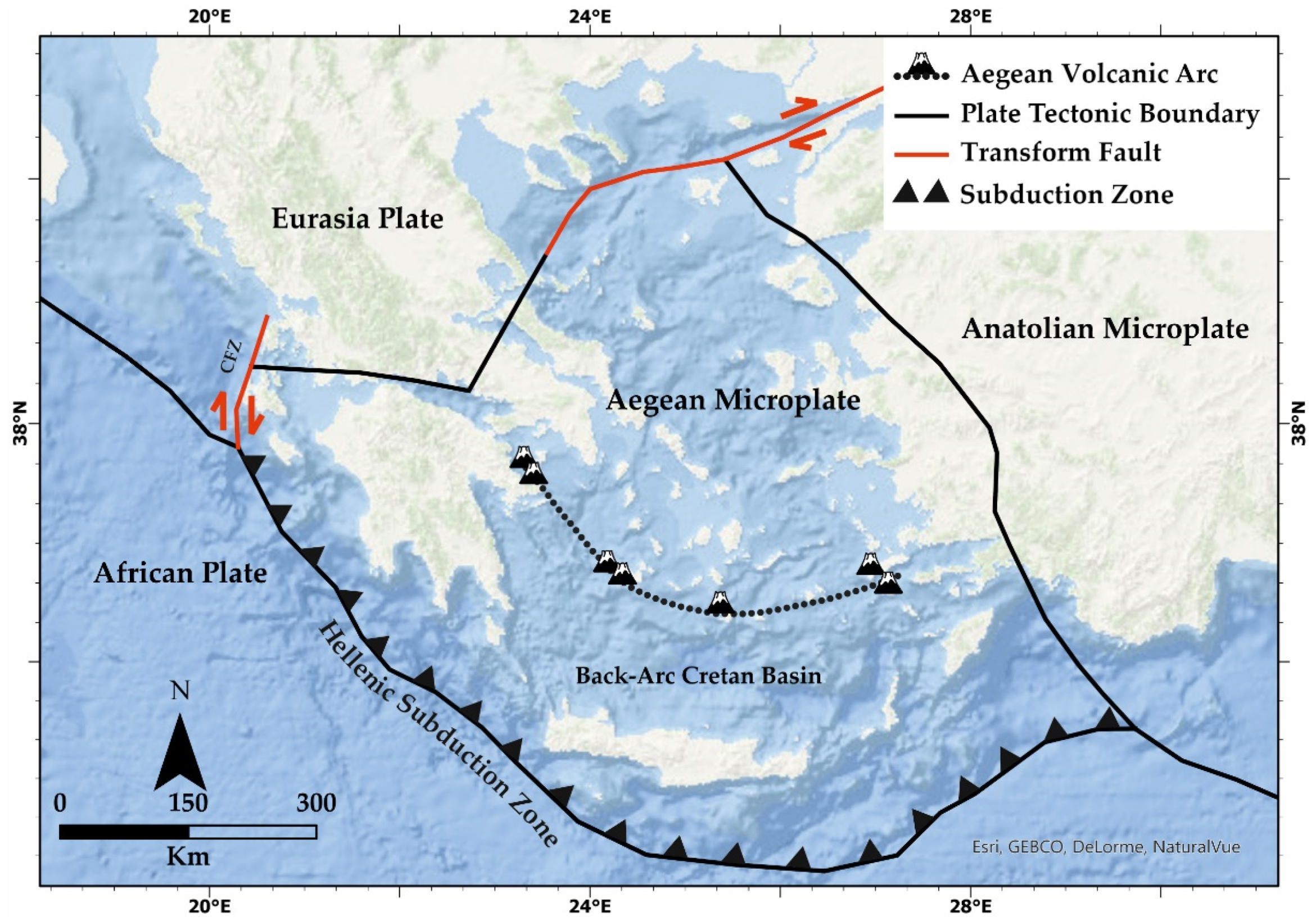
2. The Geological and Tectonic Setting of the Greek Region
3. Historical Tsunamis in the Greek Region
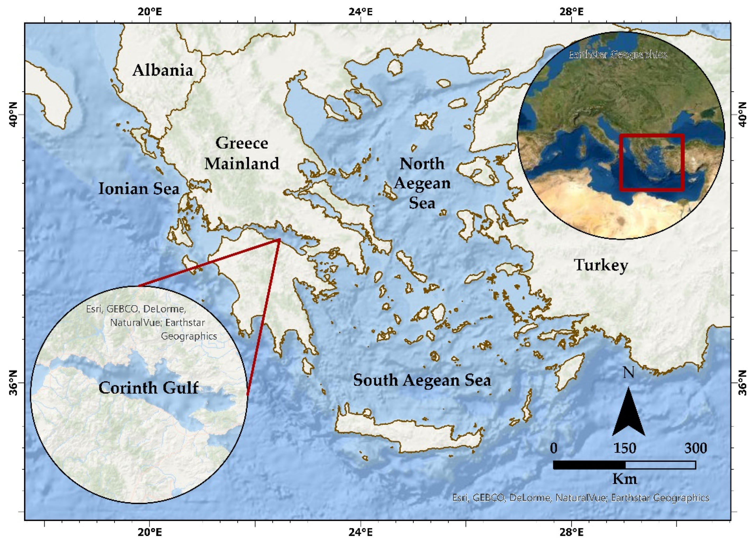
3.1. North Aegean
3.2. South Aegean
3.3. Corinth Gulf
3.4. Ionian Sea
4. Holocene Record of Tsunamis in Greece
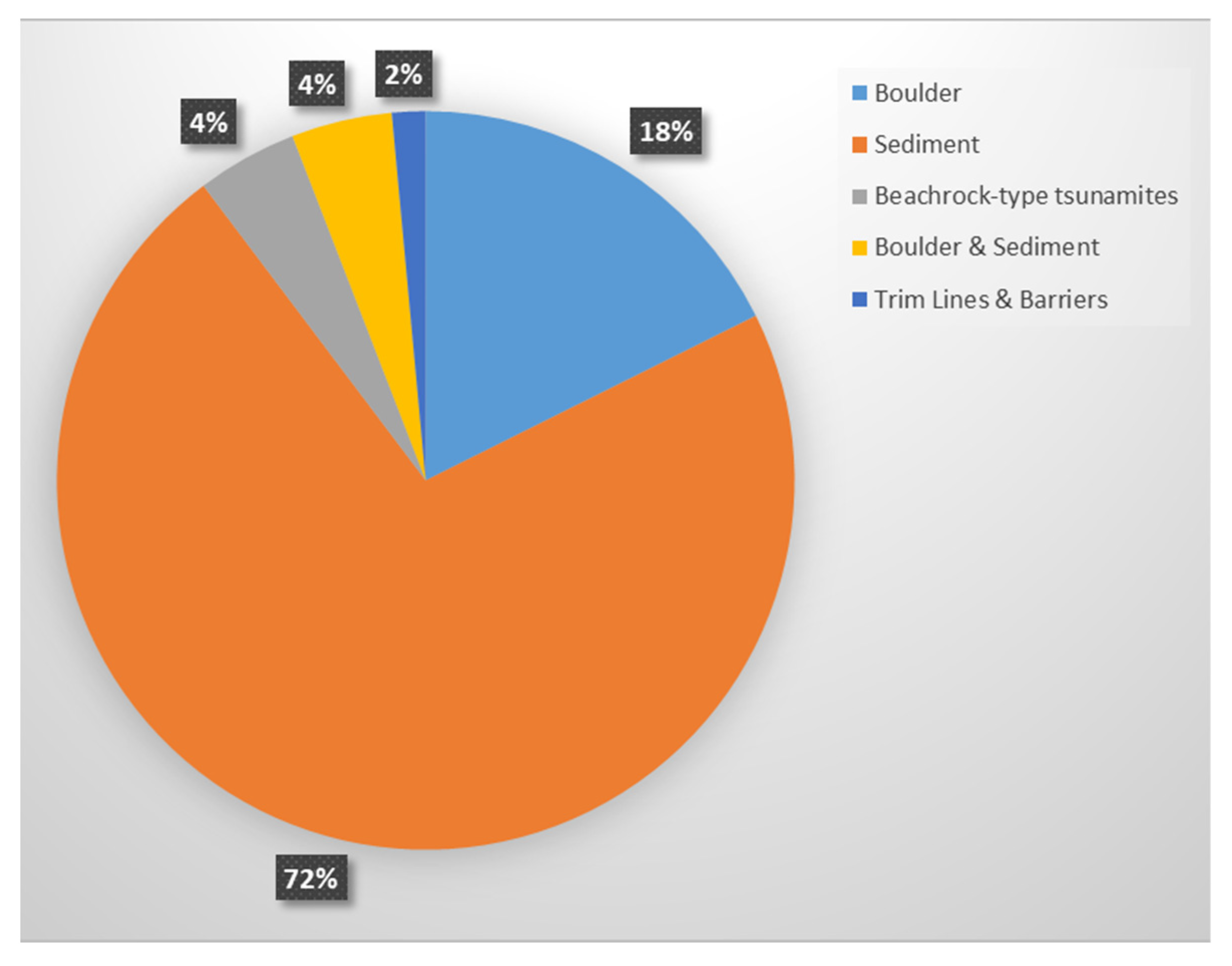
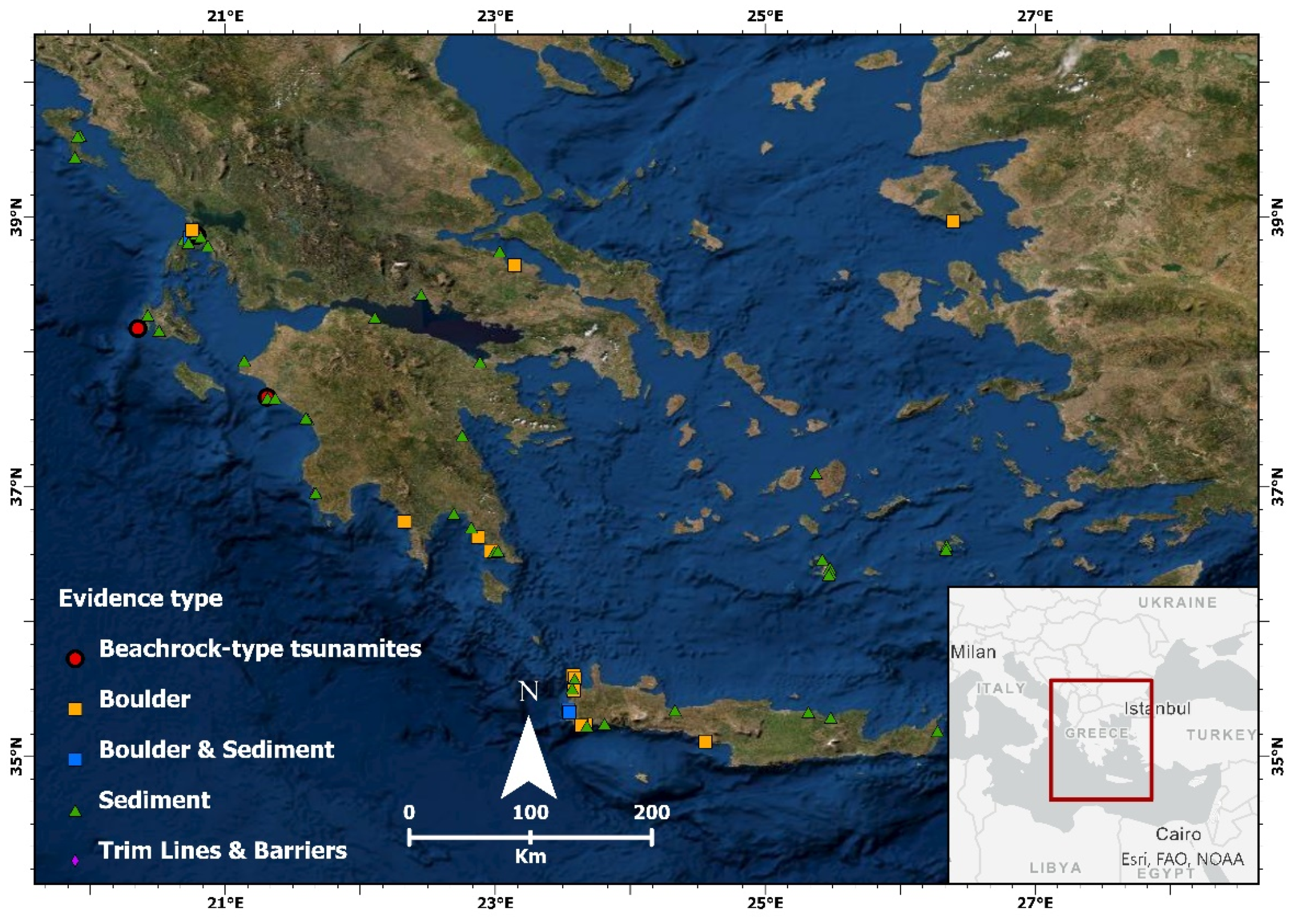
4.1. Main Geological and Geomorphological Evidence
4.2. An Overview of Field Data from Greece
5. Limitations and Knowledge Gaps/Concluding Remarks
Author Contributions
Funding
Institutional Review Board Statement
Informed Consent Statement
Data Availability Statement
Conflicts of Interest
References
- Jankaew, K.; Atwater, B.F.; Sawai, Y.; Choowong, M.; Charoentitirat, T.; Martin, M.E.; Prendergast, A. Medieval forewarning of the 2004 Indian Ocean tsunami in Thailand. Nature 2008, 455, 1228–1231. [Google Scholar] [CrossRef]
- Horton, B.P.; Rossi, V.; Hawkes, A.D. The sedimentary record of the 2005 hurricane season from the Mississippi and Alabama coastlines. Quat. Int. 2009, 195, 15–30. [Google Scholar] [CrossRef]
- Liu, W.; Yamazaki, F.; Gokon, H.; Koshimura, S. Extraction of Tsunami-Flooded Areas and Damaged Buildings in the 2011 Tohoku-Oki Earthquake from TerraSAR-X Intensity Images. Earthq. Spectra 2013, 29, 183–200. [Google Scholar] [CrossRef]
- Dawson, A.; Shi, S. Tsunami Deposits. Pure Appl. Geophys. 2000, 157, 875–897. [Google Scholar] [CrossRef]
- Gelfenbaum, G.; Jaffe, B. Erosion and Sedimentation from the 17 July, 1998 Papua New Guinea Tsunami; Birkhäuser: Basel, Switzerland, 2003; Volume 160. [Google Scholar]
- Scheffers, A.; Kelletat, D. Sedimentologic and geomorphologic tsunami imprints worldwide—A review. Earth-Sci. Rev. 2003, 63, 83–92. [Google Scholar] [CrossRef]
- Goff, J.; Chagué-Goff, C.; Nichol, S.; Jaffe, B.; Dominey-Howes, D. Progress in palaeotsunami research. Sediment. Geol. 2012, 243–244, 70–88. [Google Scholar] [CrossRef]
- England, P.; Howell, A.; Jackson, J.; Synolakis, C. Palaeotsunamis and tsunami hazards in the Eastern Mediterranean. Philos. Trans. R. Soc. A Math. Phys. Eng. Sci. 2015, 373, 20140374. [Google Scholar] [CrossRef] [PubMed]
- Marriner, N.; Kaniewski, D.; Morhange, C.; Flaux, C.; Giaime, M.; Vacchi, M.; Goff, J. Tsunamis in the geological record: Making waves with a cautionary tale from the Mediterranean. Sci. Adv. 2017, 3, e1700485. [Google Scholar] [CrossRef]
- Goto, K.; Chagué-Goff, C.; Goff, J.; Jaffe, B. The future of tsunami research following the 2011 Tohoku-oki event. Sediment. Geol. 2012, 282, 1–13. [Google Scholar] [CrossRef]
- Sugawara, D. Lessons from the 2011 Tohoku-oki tsunami. In Tsunamiites; Shiki, T., Tsuji, Y., Yamazaki, T., Nanayama, F., Eds.; Elsevier: Amsterdam, The Netherlands, 2021; pp. 155–181. [Google Scholar]
- Papadopoulos, G.A.; Gràcia, E.; Urgeles, R.; Sallares, V.; De Martini, P.M.; Pantosti, D.; González, M.; Yalciner, A.C.; Mascle, J.; Sakellariou, D.; et al. Historical and pre-historical tsunamis in the Mediterranean and its connected seas: Geological signatures, generation mechanisms and coastal impacts. Mar. Geol. 2014, 354, 81–109. [Google Scholar] [CrossRef]
- CIESM. Marine Geo-Hazards in the Mediterranean; Briand, F., Ed.; CIESM: Monaco, Monaco, 2011. [Google Scholar]
- Maramai, A. Chapter 2—Historical records: Their importance in understanding and mitigating tsunamis. In Geological Records of Tsunamis and Other Extreme Waves; Engel, M., Pilarczyk, J.E., May, S.M., Brill, D., Garrett, E., Eds.; Elsevier Inc.: Amsterdam, The Netherlands, 2020; pp. 21–31. ISBN 9780128156865. [Google Scholar]
- Dawson, A.; Stewart, I. Tsunami geoscience. Prog. Phys. Geogr. 2007, 31, 575–590. [Google Scholar] [CrossRef]
- Goff, J.; McFadgen, B.G.; Chagué-Goff, C. Sedimentary differences between the 2002 Easter storm and the 15th-century Okoropunga tsunami, southeastern North Island, New Zealand. Mar. Geol. 2004, 204, 235–250. [Google Scholar] [CrossRef]
- Tuttle, M.P.; Ruffman, A.; Anderson, T.; Jeter, H. Distinguishing Tsunami from Storm Deposits in Eastern North America: The 1929 Grand Banks Tsunami versus the 1991 Halloween Storm. Seismol. Res. Lett. 2004, 75, 117–131. [Google Scholar] [CrossRef]
- Kortekaas, S.; Dawson, A.G. Distinguishing tsunami and storm deposits: An example from Martinhal, SW Portugal. Sediment. Geol. 2007, 200, 208–221. [Google Scholar] [CrossRef]
- Morton, R.A.; Gelfenbaum, G.; Jaffe, B.E. Physical criteria for distinguishing sandy tsunami and storm deposits using modern examples. Sediment. Geol. 2007, 200, 184–207. [Google Scholar] [CrossRef]
- Hori, K.; Kuzumoto, R.; Hirouchi, D.; Umitsu, M.; Janjirawuttikul, N.; Patanakanog, B. Horizontal and vertical variation of 2004 Indian tsunami deposits: An example of two transects along the western coast of Thailand. Mar. Geol. 2007, 239, 163–172. [Google Scholar] [CrossRef]
- Etienne, S.; Buckley, M.; Paris, R.; Nandasena, A.K.; Clark, K.; Strotz, L.; Chagué-Goff, C.; Richmond, B. The use of boulders for characterising past tsunamis: Lessons from the 2004 Indian Ocean and 2009 South Pacific tsunamis. Earth-Sci. Rev. 2011, 107, 76–90. [Google Scholar] [CrossRef]
- Dominey-Howes, D.T.M.; Humphreys, G.S.; Hesse, P.P. Tsunami and palaeotsunami depositional signatures and their potential value in understanding the late-Holocene tsunami record. Holocene 2006, 16, 1095–1107. [Google Scholar] [CrossRef]
- Switzer, A.D.; Jones, B.G. Large-scale washover sedimentation in a freshwater lagoon from the southeast Australian coast: Sea-level change, tsunami or exceptionally large storm? Holocene 2008, 18, 787–803. [Google Scholar] [CrossRef]
- Engel, M.; May, S.M. Bonaire’s boulder fields revisited: Evidence for Holocene tsunami impact on the Leeward Antilles. Quat. Sci. Rev. 2012, 54, 126–141. [Google Scholar] [CrossRef]
- Engel, M.; Brückner, H. The identification of palaeo-tsunami deposits—A major challenge in coastal sedimentary research. Coastline Rep. 2011, 17, 65–80. [Google Scholar]
- Kortekaas, S.; Papadopoulos, G.A.; Ganas, A.; Cundy, A.B.; Diakantoni, A. Geological identification of historical tsunamis in the Gulf of Corinth, Central Greece. Nat. Hazards Earth Syst. Sci. 2011, 11, 2029–2041. [Google Scholar] [CrossRef]
- Papadopoulos, G.A.; Papageorgiou, A. Large earthquakes and tsunamis in the mediterranean region and its connected seas. Extrem. Nat. Hazards Disaster Risks Soc. Implic. 2012, 9781107033, 252–266. [Google Scholar] [CrossRef]
- Ambraseys, N.N.; Synolakis, C. Tsunami Catalogs for the Eastern Mediterranean, Revisited. J. Earthq. Eng. 2010, 14, 309–330. [Google Scholar] [CrossRef]
- Hindson, R.A.; Andrade, C. Sedimentation and hydrodynamic processes associated with the tsunami generated by the 1755 Lisbon earthquake. Quat. Int. 1999, 56, 27–38. [Google Scholar] [CrossRef]
- Altinok, Y.; Tinti, S.; Alpar, B.; Yalçiner, A.C.; Ersoy, Ş.; Bortolucci, E.; Armigliato, A. The Tsunami of August 17, 1999 in Izmit Bay, Turkey. Nat. Hazards 2001, 24, 133–146. [Google Scholar] [CrossRef]
- Shaw, B.; Ambraseys, N.N.; England, P.C.; Floyd, M.A.; Gorman, G.J.; Higham, T.F.G.; Jackson, J.A.; Nocquet, J.M.; Pain, C.C.; Piggott, M.D. Eastern Mediterranean tectonics and tsunami hazard inferred from the AD 365 earthquake. Nat. Geosci. 2008, 1, 268–276. [Google Scholar] [CrossRef]
- Barbano, M.S.; Pirrotta, C.; Gerardi, F. Large boulders along the south-eastern Ionian coast of Sicily: Storm or tsunami deposits? Mar. Geol. 2010, 275, 140–154. [Google Scholar] [CrossRef]
- Avşar, U. Sedimentary geochemical evidence of historical tsunamis in the Eastern Mediterranean from Ölüdeniz Lagoon, SW Turkey. J. Paleolimnol. 2019, 61, 373–385. [Google Scholar] [CrossRef]
- Smedile, A.; Molisso, F.; Chagué, C.; Iorio, M.; De Martini, P.M.; Pinzi, S.; Collins, P.E.F.; Sagnotti, L.; Pantosti, D. New coring study in Augusta Bay expands understanding of offshore tsunami deposits (Eastern Sicily, Italy). Sedimentology 2020, 67, 1553–1576. [Google Scholar] [CrossRef]
- Dominey-Howes, D. Documentary and Geological Records of Tsunamis in the Aegean Sea Region of Greece and their Potential Value to Risk Assessment and Disaster Management. Nat. Hazards 2002, 25, 195–224. [Google Scholar] [CrossRef]
- Neumann, B.; Vafeidis, A.T.; Zimmermann, J.; Nicholls, R.J. Future coastal population growth and exposure to sea-level rise and coastal flooding—A global assessment. PLoS ONE 2015, 10, e0118571. [Google Scholar] [CrossRef] [PubMed]
- Guidoboni, E.; Comastri, A.; Traina, A.G. Catalogue of Ancient Earthquakes in the Mediterranean Area up to 10th Century; Istituto Nazionale di Geofisica: Rome, Italy, 1994. [Google Scholar]
- Anzidei, M.; Lambeck, K.; Antonioli, F.; Furlani, S.; Mastronuzzi, G.; Serpelloni, E.; Vannucci, G. Coastal structure, sea-level changes and vertical motion of the land in the Mediterranean. Geol. Soc. Lond. Spec. Publ. 2014, 388, 453–479. [Google Scholar] [CrossRef]
- Faccenna, C.; Becker, T.W.; Auer, L.; Billi, A.; Boschi, L.; Brun, J.P.; Capitanio, F.A.; Funiciello, F.; Horvàth, F.; Jolivet, L.; et al. Mantle dynamics in the Mediterranean. Rev. Geophys. 2014, 52, 283–332. [Google Scholar] [CrossRef]
- Sakellariou, D.; Galanidou, N. Pleistocene submerged landscapes and Palaeolithic archaeology in the tectonically active Aegean region. Geol. Soc. Lond. Spec. Publ. 2016, 411, 145–178. [Google Scholar] [CrossRef]
- Sakellariou, D.; Mascle, J.; Lykousis, V. Strike slip tectonics and transtensional deformation in the Aegean region and the Hellenic arc: Preliminary results. Bull. Geol. Soc. Greece 2017, 47, 647–656. [Google Scholar] [CrossRef]
- Salamon, A.; Rockwell, T.; Ward, S.N.; Guidoboni, E.; Comastri, A. Tsunami hazard evaluation of the eastern Mediterranean: Historical analysis and selected modeling. Bull. Seismol. Soc. Am. 2007, 97, 705–724. [Google Scholar] [CrossRef]
- Valle, B.L.; Kalligeris, N.; Findikakis, A.N.; Okal, E.A.; Melilla, L.; Synolakis, C.E. Plausible megathrust tsunamis in the eastern Mediterranean Sea. Proc. ICE-Eng. Comput. Mech. 2014, 167, 99–105. [Google Scholar] [CrossRef]
- Papadopoulos, G.A. Tsunamis in the European-Mediterranean Region: From Historical Record to Risk Mitigation; Elsevier: Amsterdam, The Netherlands, 2016; ISBN 9780124202245. [Google Scholar]
- Ambraseys, N.N. Earthquakes in the Eastern Mediterranean and the Middle East: Multidisciplinary Study of 2000 Years of Seismicity; Cambridge University Press: Cambridge, UK, 2009. [Google Scholar]
- Papadopoulos, G.A.; Ganas, A.; Agalos, A.; Papageorgiou, A.; Triantafyllou, I.; Kontoes, C.; Papoutsis, I.; Diakogianni, G. Earthquake Triggering Inferred from Rupture Histories, DInSAR Ground Deformation and Stress-Transfer Modelling: The Case of Central Italy During August 2016–January 2017. Pure Appl. Geophys. 2017, 174, 3689–3711. [Google Scholar] [CrossRef]
- Antonopoulos, J. Catalogue of tsunamis in the Eastern Mediterranean from antiquity to present times. Ann. Géologiques des Pays Hélleniques 1979, 32, 114–130. [Google Scholar] [CrossRef]
- Triantafyllou, Ι.; Zaniboni, F.; Armigliato, A.; Tinti, S.; Papadopoulos, G.A. The Large Earthquake (~ M7) and Its Associated Tsunami of 8 November 1905 in Mt. Athos, Northern Greece. Pure Appl. Geophys. 2019, 177, 1267–1293. [Google Scholar] [CrossRef]
- Papazachos, V.; Papazachou, K. The Earthquakes of Greece, 3rd ed.; ZITI: Thessaloniki, Greece, 2003. [Google Scholar]
- Sieberg, A. Die Erdbeben. Handb. Der Geophys. 1932, IV, 687–1005. [Google Scholar]
- Sieberg, A. Untersuchungen Über Erdbeben und Bruchschollenbau im Östlichen Mittelmeergebeit; Denkschr. Med. Naturw. Ges.: Jena, Germany, 1932. [Google Scholar]
- Papadopoulos, G.A.; Daskalaki, E.; Fokaefs, A.; Giraleas, N. Tsunami hazards in the Eastern Mediterranean: Strong earthquakes and tsunamis in the East Hellenic Arc and Trench system. Nat. Hazards Earth Syst. Sci. 2007, 7, 57–64. [Google Scholar] [CrossRef]
- Papazachos, B.C.; Koutitas, C.; Hatzidimitriou, P.M.; Karacostas, B.G.; Papaioannou, C.A. Tsunami hazard in Greece and the surrounding area. Ann. Geophys. 1986, 4, 79–90. [Google Scholar]
- Lekkas, Ε.; Carydis, P.; Mavroulis, S.; Gogou, M.; Andreadakis, E.; Katsetsiadou, K.-N.; Skourtsos, E.; Minos-Minopoulos, D.; Bardouli, P.; Voulgaris, N.; et al. The Mw 6.6, July 21, 2017 Kos Earthquake, Scientific Report (Version 2.0); National and Kapodistrian University of Athens: Athens, Greece, 2017. [Google Scholar]
- Papadopoulos, G.; Agalos, A.; Charalampakis, M.; Kontoes, C.; Papoutsis, I.; Atzori, S.; Svigkas, N.; Triantafyllou, I. Fault models for the Bodrum–Kos tsunamigenic earthquake (Mw6.6) of 20 July 2017 in the east Aegean Sea. J. Geodyn. 2019, 131, 101646. [Google Scholar] [CrossRef]
- Ambraseys, N. Earthquakes in the Eastern Mediterranean and the Middle East; Cambridge University Press: New York, NY, USA, 2009; ISBN 9780521872928. [Google Scholar]
- Georgiades, A.S. About Earthquakes and Antiseismic Buildings (in Greek); S. Kousoulinos: Athens, Greece, 1904. [Google Scholar]
- Evagelatou-Notara, F. Earthquakes in Byzantium from 13th to 15th Century—A Historical Examination; Parousia: Athens, Greece, 1993; ISBN 960-852025-8. [Google Scholar]
- Ambraseys, N.N. Data for the investigation of the seismic sea-waves in the Eastern Mediterranean. Bull. Seismol. Soc. Am. 1962, 52, 895–913. [Google Scholar]
- Ambraseys, N.N.; Srbulov, M. Attenuation of earthquake-induced ground displacements. Earthq. Eng. Struct. Dyn. 1994, 23, 467–487. [Google Scholar] [CrossRef]
- Soloviev, S.L. Tsunamigenic zones in the Mediterranean Sea. Nat. Hazards 1990, 3, 183–202. [Google Scholar] [CrossRef]
- Guidoboni, E.; Comastri, A. The large earthquake of 8 August 1303 in Crete: Seismic scenario and tsunami in the Mediterranean area. J. Seismol. 1997, 1, 55–72. [Google Scholar] [CrossRef]
- Vött, A.; Brückner, H.; May, M.; Lang, F.; Herd, R.; Brockmüller, S. Strong tsunami impact on the Bay of Aghios Nikolaos and its environs (NW Greece) during Classical–Hellenistic times. Quat. Int. 2008, 181, 105–122. [Google Scholar] [CrossRef]
- Papadopoulos, G.A.; Daskalaki, E.; Fokaefs, A.; Giraleas, N. Tsunami hazard in the Eastern Mediterranean sea: Strong earthquakes and tsunamis in the west Hellenic arc and trench system. J. Earthq. Tsunami 2010, 04, 145–179. [Google Scholar] [CrossRef]
- Okal, E.A.; Synolakis, C.E.; Uslu, B.; Kalligeris, N.; Voukouvalas, E. The 1956 earthquake and tsunami in Amorgos, Greece. Geophys. J. Int. 2009, 178, 1533–1554. [Google Scholar] [CrossRef]
- Triantafyllou, I.; Papadopoulos, G.A.; Lekkas, E. Impact on built and natural environment of the strong earthquakes of April 23, 1933, and July 20, 2017, in the southeast Aegean Sea, eastern Mediterranean. Nat. Hazards 2019, 100, 671–695. [Google Scholar] [CrossRef]
- Yalçıner, A.C.; Annunziato, A.; Papadopoulos, G.A.; Dogan, G.G.; Guler, H.G.; Sozdinler, C.O.; Ulutas, E.; Arikawa, T.; Suzen, M.L.; Tufekci, D.; et al. THE JULY 20, 2017 BODRUM/KOS EARTHQUAKE AND TSUNAMI: FIELD SURVEYS, LESSONS and MODELING. Coast. Eng. Proc. 2018, 20, 82. [Google Scholar] [CrossRef]
- Triantafyllou, Ι.; Gogou, M.; Mavroulis, S.; Katerina-Navsika, K.; Lekkas, E.; Papadopoulos, G.A. The Tsunami Caused by the 30 October 2020 Samos (Greece), East Aegean Sea, Mw6.9 Earthquake: Impact Assessment from Post—Event Field Survey and Video; National and Kapodistrian University of Athens: Athens, Greece, 2020. [Google Scholar]
- Papadopoulos, G.A. Tsunami Hazard in the Eastern Mediterranean: Strong Earthquakes and Tsunamis in the Corinth Gulf, Central Greece. Nat. Hazards 2003, 29, 437–464. [Google Scholar] [CrossRef]
- Galanopoulos, A.G.; Delibasis, N.; Comninakis, P. A tsunami generated by an earth slump set in motion without shock. Ann. Géologiques des Pays Helléniques 1964, 16, 93–110. [Google Scholar]
- Ambraseys, N.N.; Jackson, J.A. Seismicity and associated strain of central Greece between 1890 and 1988. Geophys. J. Int. 1990, 101, 663–708. [Google Scholar] [CrossRef]
- Papadopoulos, G.A.; Chalkis, B.J. Tsunamis observed in Greece and the surrounding area from antiquity up to the present times. Mar. Geol. 1984, 56, 309–317. [Google Scholar] [CrossRef]
- Papathanassiou, G.; Pavlides, S.; Ganas, A. The 2003 Lefkada earthquake: Field observations and preliminary microzonation map based on liquefaction potential index for the town of Lefkada. Eng. Geol. 2005, 82, 12–31. [Google Scholar] [CrossRef]
- Lekkas, E.; Mavroulis, S.; Carydis, P.; Alexoudi, V. The 17 November 2015 Mw 6.4 Lefkas (Ionian Sea, Western Greece) Earthquake: Impact on Environment and Buildings. Geotech. Geol. Eng. 2018, 36, 2109–2142. [Google Scholar] [CrossRef]
- Ganas, A.; Briole, P.; Bozionelos, G.; Barberopoulou, A.; Elias, P.; Tsironi, V.; Valkaniotis, S.; Moshou, A.; Mintourakis, I. The 25 October 2018 Mw = 6.7 Zakynthos earthquake (Ionian Sea, Greece): A low-angle fault model based on GNSS data, relocated seismicity, small tsunami and implications for the seismic hazard in the west Hellenic Arc. J. Geodyn. 2020, 137, 101731. [Google Scholar] [CrossRef]
- Antonopoulos, J.A. Data from investigation on seismic Sea waves events in the Eastern Mediterranean from 1000 to 1500 A.D. Ann. di Geofis. 1980, 19, 141–248. [Google Scholar] [CrossRef]
- Watanabe, M.; Goto, K.; Bricker, J.D.; Imamura, F. Are inundation limit and maximum extent of sand useful for differentiating tsunamis and storms? An example from sediment transport simulations on the Sendai Plain, Japan. Sediment. Geol. 2018, 364, 204–216. [Google Scholar] [CrossRef]
- Chagué-Goff, C.; Szczuciński, W.; Shinozaki, T. Applications of geochemistry in tsunami research: A review. Earth-Sci. Rev. 2017, 165, 203–244. [Google Scholar] [CrossRef]
- Engel, M.; Schön, I.; Patel, T.; Pawłowski, J.; Szczuciński, W.; Dawson, S.; Garrett, E.; Heyvaert, V.M.A. Paleogenetic approaches in tsunami deposit studies. In Geological Records of Tsunamis and Other Extreme Waves; Elsevier: Amsterdam, The Netherlands, 2020; pp. 427–442. [Google Scholar]
- Yap, W.; Switzer, A.D.; Gouramanis, C.; Marzinelli, E.; Wijaya, W.; Yan, Y.T.; Dominey-Howes, D.; Labbate, M.; Srinivasalu, S.; Jankaew, K.; et al. Environmental DNA signatures distinguish between tsunami and storm deposition in overwash sand. Commun. Earth Environ. 2021, 2, 129. [Google Scholar] [CrossRef]
- Scheffers, A.; Scheffers, S. Tsunami deposits on the coastline of west Crete (Greece). Earth Planet. Sci. Lett. 2007, 259, 613–624. [Google Scholar] [CrossRef]
- Shah-Hosseini, M.; Saleem, A.; Mahmoud, A.M.A.; Morhange, C. Coastal boulder deposits attesting to large wave impacts on the Mediterranean coast of Egypt. Nat. Hazards 2016, 83, 849–865. [Google Scholar] [CrossRef]
- Piscitelli, A.; Milella, M.; Hippolyte, J.-C.; Shah-Hosseini, M.; Morhange, C.; Mastronuzzi, G. Numerical approach to the study of coastal boulders: The case of Martigues, Marseille, France. Quat. Int. 2017, 439, 52–64. [Google Scholar] [CrossRef]
- Boulton, S.J.; Whitworth, M.R.Z. Block and boulder accumulations on the southern coast of Crete (Greece): Evidence for the 365 CE tsunami in the Eastern Mediterranean. In Tsunamis: Geology, Hazards and Risks; Chapman, N.A., Tappin, D.R., Wallis, S.R., Eds.; The Geological Society of London: London, UK, 2017. [Google Scholar]
- Roig-Munar, F.X.; Rodríguez-Perea, A.; Martín-Prieto, J.A.; Gelabert, B.; Vilaplana, J.M. Tsunami boulders on the rocky coasts of Ibiza and Formentera (Balearic Islands). J. Mar. Sci. Eng. 2019, 7, 327. [Google Scholar] [CrossRef]
- Evelpidou, N.; Zerefos, C.; Synolakis, C.; Repapis, C.; Karkani, A.; Polidorou, M.; Saitis, G. Coastal Boulders on the SE Coasts of Cyprus as Evidence of Palaeo-Tsunami Events. J. Mar. Sci. Eng. 2020, 8, 812. [Google Scholar] [CrossRef]
- Nott, J. Waves, coastal boulder deposits and the importance of the pre-transport setting. Earth Planet. Sci. Lett. 2003, 210, 269–276. [Google Scholar] [CrossRef]
- Pignatelli, C.; Sansò, P.; Mastronuzzi, G. Evaluation of tsunami flooding using geomorphologic evidence. Mar. Geol. 2009, 260, 6–18. [Google Scholar] [CrossRef]
- Benner, R.; Browne, T.; Bruckner, H.; Kelletat, D.; Scheffers, A. Boulder Transport by Waves: Progress in Physical Modelling. Z. für Geomorphol. 2010, 54, 127–146. [Google Scholar] [CrossRef]
- Nandasena, N.A.K.; Tanaka, N.; Sasaki, Y.; Osada, M. Boulder transport by the 2011 Great East Japan tsunami: Comprehensive field observations and whither model predictions? Mar. Geol. 2013, 346, 292–309. [Google Scholar] [CrossRef]
- Cox, R.; Ardhuin, F.; Dias, F.; Autret, R.; Beisiegel, N.; Earlie, C.S.; Herterich, J.G.; Kennedy, A.; Paris, R.; Raby, A.; et al. Systematic Review Shows That Work Done by Storm Waves Can Be Misinterpreted as Tsunami-Related Because Commonly Used Hydrodynamic Equations Are Flawed. Front. Mar. Sci. 2020, 7, 4. [Google Scholar] [CrossRef]
- Seike, K.; Kitahashi, T.; Noguchi, T. Sedimentary features of Onagawa Bay, northeastern Japan after the 2011 off the Pacific coast of Tohoku Earthquake: Sediment mixing by recolonized benthic animals decreases the preservation potential of tsunami deposits. J. Oceanogr. 2015, 72, 141–149. [Google Scholar] [CrossRef]
- Bellanova, P.; Frenken, M.; Nishimura, Y.; Schwarzbauer, J.; Reicherter, K. Tracing woody-organic tsunami deposits of the 2011 Tohoku-oki event in Misawa (Japan). Sci. Rep. 2021, 11, 8947. [Google Scholar] [CrossRef]
- Chagué-Goff, C.; Andrew, A.; Szczuciński, W.; Goff, J.; Nishimura, Y. Geochemical signatures up to the maximum inundation of the 2011 Tohoku-oki tsunami—Implications for the 869 AD Jogan and other palaeotsunamis. Sediment. Geol. 2012, 282, 65–77. [Google Scholar] [CrossRef]
- Sugawara, D.; Goto, K. Numerical modeling of the 2011 Tohoku-oki tsunami in the offshore and onshore of Sendai Plain, Japan. Sediment. Geol. 2012, 282, 110–123. [Google Scholar] [CrossRef]
- Goto, K.; Sugawara, D.; Ikema, S.; Miyagi, T. Sedimentary processes associated with sand and boulder deposits formed by the 2011 Tohoku-oki tsunami at Sabusawa Island, Japan. Sediment. Geol. 2012, 282, 188–198. [Google Scholar] [CrossRef]
- Naruse, H.; Arai, K.; Matsumoto, D.; Takahashi, H.; Yamashita, S.; Tanaka, G.; Murayama, M. Sedimentary features observed in the tsunami deposits at Rikuzentakata City. Sediment. Geol. 2012, 282, 199–215. [Google Scholar] [CrossRef][Green Version]
- Hayashi, S.; Koshimura, S. The 2011 Tohoku Tsunami Flow Velocity Estimation by the Aerial Video Analysis and Numerical Modeling. J. Disaster Res. 2013, 8, 561–572. [Google Scholar] [CrossRef]
- Szczuciński, W.; Kokociński, M.; Rzeszewski, M.; Chagué-Goff, C.; Cachão, M.; Goto, K.; Sugawara, D. Sediment sources and sedimentation processes of 2011 Tohoku-oki tsunami deposits on the Sendai Plain, Japan—Insights from diatoms, nannoliths and grain size distribution. Sediment. Geol. 2012, 282, 40–56. [Google Scholar] [CrossRef]
- Ishizawa, T.; Goto, K.; Yokoyama, Y.; Goff, J. Dating tsunami deposits: Present knowledge and challenges. Earth-Sci. Rev. 2020, 200, 102971. [Google Scholar] [CrossRef]
- May, S.M.; Vött, A.; Brückner, H.; Brockmüller, S. Evidence of tsunamigenic impact on Actio headland. Coastline Rep. 2007, 9, 115–125. [Google Scholar]
- Scheffers, A.; Kelletat, D.; Vött, A.; May, S.M.; Scheffers, S. Late Holocene tsunami traces on the western and southern coastlines of the Peloponnesus (Greece). Earth Planet. Sci. Lett. 2008, 269, 271–279. [Google Scholar] [CrossRef]
- Evelpidou, N.; Pirazzoli, P.; Vassilopoulos, A.; Tomasin, A. Holocene submerged shorelines on Theologos area (Greece). Z. für Geomorphol. 2011, 55, 31–44. [Google Scholar] [CrossRef]
- Vacchi, M.; Rovere, A.; Zouros, N.; Firpo, M. Assessing enigmatic boulder deposits in NE Aegean Sea: Importance of historical sources as tool to support hydrodynamic equations. Nat. Hazards Earth Syst. Sci. 2012, 12, 1109–1118. [Google Scholar] [CrossRef]
- Pirazzoli, P.A.; Ausseil-Badie, J.; Giresse, P.; Hadjidaki, E.; Arnold, M. Historical environmental changes at phalasarna harbor, West Crete. Geoarchaeology 1992, 7, 371–392. [Google Scholar] [CrossRef]
- Evelpidou, N.; Tziligkaki, E.; Karkani, A. Submerged antiquities on Paros and Naxos islands, Aegean Sea, Greece. New evidence for the mean sea level during the late Bronze Age and the Roman period. Bull. Geol. Soc. Greece 2018, 52, 71–97. [Google Scholar] [CrossRef]
- Dominey-Howes, D.; Cundy, A.; Croudace, I. High energy marine flood deposits on Astypalaea Island, Greece: Possible evidence for the AD 1956 southern Aegean tsunami. Mar. Geol. 2000, 163, 303–315. [Google Scholar] [CrossRef]
- Marriner, N.; Morhange, C.; Skrimshire, S. Geoscience meets the four horsemen?: Tracking the rise of neocatastrophism. Glob. Planet. Chang. 2010, 74, 43–48. [Google Scholar] [CrossRef]
- Vött, A.; Brückner, H.; May, S.M.; Sakellariou, D.; Nelle, O.; Lang, F.; Kapsimalis, V.; Jahns, S.; Herd, R.; Handl, M.; et al. The Lake Voulkaria (Akarnania, NW Greece) palaeoenvironmental archive a sediment trap for multiple tsunami impact since the mid-Holocene. Z. für Geomorphol. Suppl. Issues 2009, 53, 1–37. [Google Scholar] [CrossRef]
- Vött, A.; Bareth, G.; Brückner, H.; Lang, F.; Sakellariou, D.; Hadler, H.; Ntageretzis, K.; Willershäuser, T. Olympia’s Harbour site Pheia (Elis, Western Peloponnese, Greece) destroyed by Tsunami impact. Erde 2011, 142, 259–288. [Google Scholar]
- Vott, A.; Hadler, H.; Willershäuser, T.; Ntageretzis, K.; Bruckner, H.; Warnecke, H.; Grootes, P.M.; Lang, F.; Nelle, O.; Sakellariou, D. Ancient harbours used as tsunami sediment traps—The case study of Krane (Cefalonia Island, Greece). BYZAS 2014, 19, 743–771. [Google Scholar]
- Hadler, H.; Baika, K.; Pakkanen, J.; Evangelistis, D.; Emde, K.; Fischer, P.; Ntageretzis, K.; Röbke, B.; Willershäuser, T.; Vött, A. Palaeotsunami impact on the ancient harbour site Kyllini (western Peloponnese, Greece) based on a geomorphological multi-proxy approach. Z. für Geomorphol. Suppl. Issues 2015, 59, 7–41. [Google Scholar] [CrossRef]
- Koster, B.; Vött, A.; Mathes-Schmidt, M.; Reicherter, K. Geoscientific investigations in search of tsunami deposits in the environs of the Agoulinitsa peatland, Kaiafas Lagoon and Kakovatos (Gulf of Kyparissia, western Peloponnese, Greece). Z. für Geomorphol. Suppl. Issues 2015, 59, 125–156. [Google Scholar] [CrossRef]
- Werner, V.; Baika, K.; Fischer, P.; Hadler, H.; Obrocki, L.; Willershäuser, T.; Tzigounaki, A.; Tsigkou, A.; Reicherter, K.; Papanikolaou, I.; et al. The sedimentary and geomorphological imprint of the AD 365 tsunami on the coasts of southwestern Crete (Greece)—Examples from Sougia and Palaiochora. Quat. Int. 2018, 473, 66–90. [Google Scholar] [CrossRef]
- Werner, V.; Baika, K.; Tzigounaki, A.; Reicherter, K.; Papanikolaou, I.; Emde, K.; Fischer, P.; Vött, A. Mid-Holocene tectonic geomorphology of northern Crete deduced from a coastal sedimentary archive near Rethymnon and a Late Bronze Age Santorini tsunamite candidate. Geomorphology 2019, 326, 167–189. [Google Scholar] [CrossRef]
- Galanopoulos, A.G. The seismic sea-wave of 9 July 1956. Proc. Acad. Athens 1957, 32, 90–101. [Google Scholar]
- Ambraseys, N.N. The seismic sea wave of July 9, 1956, in the Greek archipelago. J. Geophys. Res. 1960, 65, 1257–1265. [Google Scholar] [CrossRef]
- Papazachos, B.C.; Koutitas, C.; Hatzidimitriou, P.M.; Karacostas, B.G.; Papaioannou, C.A. Source and short-distance propagation of the July 9, 1956 southern Aegean tsunami. Mar. Geol. 1985, 65, 343–351. [Google Scholar] [CrossRef]
- Ntageretzis, K.; Vött, A.; Fischer, P.; Hadler, H.; Emde, K.; Röbke, B.R.; Willershäuser, T. Palaeotsunami history of the Elos Plain (Evrotas River delta, Peloponnese, Greece). Z. fur Geomorphol. 2015, 59, 253–273. [Google Scholar] [CrossRef]
- Ntageretzis, K.; Vött, A.; Fischer, P.; Hadler, H.; Emde, K.; Röbke, B.R.; Willershäuser, T. Traces of repeated tsunami landfall in the vicinity of Limnothalassa Moustou (Gulf of Argolis—Peloponnese, Greece). Z. fur Geomorphol. 2015, 59, 301–317. [Google Scholar] [CrossRef]
- Minoura, K.; Imamura, F.; Kuran, U.; Nakamura, T.; Papadopoulos, G.A.; Takahashi, T.; Yalciner, A.C. Discovery of Minoan tsunami deposits. Geology 2000, 28, 59. [Google Scholar] [CrossRef]
- Bruins, H.J.; MacGillivray, J.A.; Synolakis, C.E.; Benjamini, C.; Keller, J.; Kisch, H.J.; Klügel, A.; van der Plicht, J. Geoarchaeological tsunami deposits at Palaikastro (Crete) and the Late Minoan IA eruption of Santorini. J. Archaeol. Sci. 2008, 35, 191–212. [Google Scholar] [CrossRef]
- Vött, A.; Fischer, P.; Röbke, B.R.; Werner, V.; Emde, K.; Finkler, C.; Hadler, H.; Handl, M.; Ntageretzis, K.; Willershäuser, T. Holocene fan alluviation and terrace formation by repeated tsunami passage at Epitalio near Olympia (Alpheios River valley, Greece). Z. für Geomorphol. Suppl. Issues 2015, 59, 81–123. [Google Scholar] [CrossRef]
- Vött, A.; Bareth, G.; Brückner, H.; Curdt, C.; Fountoulis, I.; Grapmayer, R.; Hadler, H.; Hoffmeister, D.; Klasen, N.; Lang, F.; et al. Beachrock-type calcarenitic tsunamites along the shores of the eastern Ionian Sea (western Greece)—Case studies from Akarnania, the Ionian Islands and the western Peloponnese. Z. für Geomorphol. Suppl. Issues 2010, 54, 1–50. [Google Scholar] [CrossRef]
- Vött, A.; Lang, F.; Brückner, H.; Gaki-Papanastassiou, K.; Maroukian, H.; Papanastassiou, D.; Giannikos, A.; Hadler, H.; Handl, M.; Ntageretzis, K.; et al. Sedimentological and geoarchaeological evidence of multiple tsunamigenic imprint on the Bay of Palairos-Pogonia (Akarnania, NW Greece). Quat. Int. 2011, 242, 213–239. [Google Scholar] [CrossRef]
- May, S.M.; Vött, A.; Brückner, H.; Grapmayer, R.; Handl, M.; Wennrich, V. The Lefkada barrier and beachrock system (NW Greece)—Controls on coastal evolution and the significance of extreme wave events. Geomorphology 2012, 139–140, 330–347. [Google Scholar] [CrossRef]
- Willershäuser, T.; Vött, A.; Brückner, H.; Bareth, G.; Nelle, O.; Nadeau, M.-J.; Hadler, H.; Ntageretzis, K. Holocene tsunami landfalls along the shores of the inner Gulf of Argostoli (Cefalonia Island, Greece). Z. für Geomorphol. Suppl. Issues 2013, 57, 105–138. [Google Scholar] [CrossRef]
- Vött, A.; Bruins, H.J.; Gawehn, M.; Goodman-Tchernov, B.N.; De Martini, P.M.; Kelletat, D.; Mastronuzzi, G.; Reicherter, K.; Röbke, B.R.; Scheffers, A.; et al. Publicity waves based on manipulated geoscientific data suggesting climatic trigger for majority of tsunami findings in the Mediterranean—Response to “Tsunamis in the geological record: Making waves with a cautionary tale from the Mediterranean” by Marr. Z. für Geomorphol. Suppl. Issues 2019, 62, 7–45. [Google Scholar] [CrossRef]
- Hadler, H.; Koster, B.; Mathes-schmidt, M. Lechaion, the Ancient Harbour of Corinth (Peloponnese, Greece) destroyed by tsunamigenic impact. In Proceedings of the 2nd INQUA-IGCP-567 International Workshop on Active Tectonics, Earthquake Geology, Archaeology and Engineering, Corinth, Greece, 19–24 September 2011; pp. 70–73. [Google Scholar]
- Hadler, H.; Vött, A.; Koster, B.; Mathes-Schmidt, M.; Mattern, T.; Ntageretzis, A.K.; Reicherter, K.; Willershäuser, T. Multiple late-Holocene tsunami landfall in the eastern Gulf of Corinth recorded in the palaeotsunami geo-archive at Lechaion, harbour of ancient Corinth (Peloponnese, Greece). Z. für Geomorphol. Suppl. Issues 2013, 57, 139–180. [Google Scholar] [CrossRef]
- Short, A.D. Carbonate Sandy Beaches. In Encyclopedia of Coastal Science; Schwartz, M.L., Ed.; Springer: Dordrecht, The Netherlands, 2005; pp. 218–221. [Google Scholar]
- Turner, R. Formation and Distribution of Beachrock. In Encyclopedia of Coastal Science; Schwartz, M., Ed.; Kluwer Academic Publishers: Dordrecht, The Netherlands, 2005; pp. 183–186. [Google Scholar]
- Vousdoukas, M.I.; Velegrakis, A.F.; Plomaritis, T.A. Beachrock occurrence, characteristics, formation mechanisms and impacts. Earth-Sci. Rev. 2007, 85, 23–46. [Google Scholar] [CrossRef]
- Bird, E. Coastal Geomorphology: An Introduction; John Wiley: Chichester, UK, 2008; ISBN 978-0-470-51729-1. [Google Scholar]
- Tucker, M.E.; Wright, V.P. Carbonate Sedimentology; Blackwell Publishing Ltd.: Oxford, UK, 1990; ISBN 9781444314175. [Google Scholar]
- Allaby, M. A Dictionary of Geology and Earth Sciences; Oxford University Press: Oxford, UK, 2020; ISBN 9780198839033. [Google Scholar]
- James, N.P.; Jones, B. Origin of Carbonate Sedimentary Rocks; John Wiley & Sons Ltd.: Hoboken, NJ, USA, 2015; ISBN 978-1-118-65270-1. [Google Scholar]
- Evelpidou, N.; Karkani, A.; Kampolis, I. Relative Sea Level Changes and Morphotectonic Implications Triggered by the Samos Earthquake of 30th October 2020. J. Mar. Sci. Eng. 2021, 9, 40. [Google Scholar] [CrossRef]
- Lekkas, E.; Mavroulis, S.; Gogou, M.; Papadopoulos, G.A.; Triantafyllou, I.; Katsetsiadou, K.-N.; Kranis, H.; Skourtsos, E.; Carydis, P.; Voulgaris, N.; et al. The October 30, 2020, Mw 6.9 Samos (Greece) earthquake. Newsl. Environ. Disaster Cris. Manag. Strateg. 2020, 21, 156. [Google Scholar]
- Gogou, M.; Macri, E.; Katsetsiadou, K.-N.; Evelpidou, N.; Karkani, E.; Lekkas, E. TSUNAMI HAZARD AND SAND DUNE PROTECTION IN WEST NAXOS ISL., GREECE. In Proceedings of the SafeCorfu 2019—6th International Conference on Civil Protection & New Technologies, Corfu Island, Greece, 6–9 November 2019; pp. 57–60. [Google Scholar]


| North Aegean | ||||
|---|---|---|---|---|
| No | Event | Magnitude | Affected Area | Reference |
| 1 | April 479 BC | 7.0 | Potidaea, Chalkidiki Peninsula | [12,45] |
| 2 | 426 BC | Maliac Gulf, Oreus Gulf, Euboean Gulf, Phthiotian coasts, Euboean coasts, Island of Skopelos | [46,47] | |
| 3 | 20 March 1389 | 6.7 | Islands of Ikaria and Chios | [45,47] |
| 4 | 28 June 1585 | 7.0 | Mt Athos | [48] |
| 5 | 13 November 1856 | 6.3 | Eastern Sporades, Chios Island | [49] |
| 6 | 3 April 1881 | 6.5 | Chios Island | [49,50,51] |
| 7 | 8 November 1905 | 7.5 | Mt Athos | [48] |
| 8 | 26 September 1932 | 7.0 | Chalkidiki, Strymonic Gulf | [12,47] |
| 9 | 9 February 1948 | 7.1 | Karpathos Island | [12,47,52] |
| 10 | 19 February 1968 | 7.1 | Agios Efstratios, Limnos, Lesvos and Euboea Islands | [47,49] |
| 11 | 15 July 1983 | 6.4 | Limnos and Lesvos Islands | [53] |
| 12 | 12 June 2017 | 6.3 (Mw) | Lesvos Island | [52,54,55] |
| South Aegean | ||||
| 1 | 142 AD | 7.6 | Rhodes, Kos, Serifos and Symi Islands | [12,47,56] |
| 2 | 21 July 365 | 8.3 | Crete, Methoni (SW Messinia), Epidaurus, Achaia (NW Peloponnese), Beeotian coasts, Epirus, Alexandria, Sicily (Italy), Dalmatian coast (Adriatic Sea) | [47,49,56] |
| 3 | August 556 | 7.0 | Kos Island | [12,49,57] |
| 4 | 18 August 1303 | 8.0 | Rhodes Island | [37,49,58,59,60] |
| 5 | 3 October 1481 | 7.2 | Rhodes Island | [47,56] |
| 6 | 1 July 1494 | 7.5 | Heraklion (Crete) | [47,56] |
| 7 | April 1609 | 7.2 | Rhodes Island | [12,56] |
| 8 | 8 November 1612 | 7.2 | Heraklion (Crete) | [61,62,63] |
| 9 | 9 March 1630 | 7.3 | Crete, Milos and Kythira Islands | [64] |
| 10 | 31 January 1741 | 7.4 | Rhodes Island | [12,56] |
| 11 | 12 October 1856 | 7.7 | Heraklion, Haifa and Lebanon | [56] |
| 12 | 6 February 1866 | 6.0 | Kythira Island, South coasts of Peloponnese | [12,47,56] |
| 13 | 16 July 1955 | 6.9 | Agathonisi and Samos Islands | [49] |
| 14 | 9 July 1956 | 7.5 | Amorgos, Astipalaea, Pholegandros, Patmos, Kalimnos, Crete and Tinos Islands, Asia Minor | [12,47,65] |
| 15 | 21 July 2017 | 6.6 (Mw) | Kos Island | [54,66,67] |
| 16 | 30 October 2020 | 6.9 (Mw) | Samos Island, East coast of Turkey | [68] |
| Corinth Gulf | ||||
| 1 | 373 BC | at least 6.6 | Eliki (Aigio) | [44,56] |
| 2 | June 1402 | Xylokastro | [37,69] | |
| 3 | 1748 | Aigio | [69] | |
| 4 | 11 June 1794 | North coast of Corinth Gulf | [69] | |
| 5 | 23 August 1817 | West coast of Corinth Gulf | [12,47] | |
| 6 | 7 February 1963 | West coast of Corinth Gulf | [12,47,70] | |
| 7 | 6 July 1965 | Gulf of Korinth. Itea bay. | [47] | |
| 8 | 11 February 1984 | Corinth Gulf | [12] | |
| 9 | 15 June 1995 | Corinth Gulf | [12] | |
| 10 | 1 January 1996 | Aigio | [12,69] | |
| Ionian Sea | ||||
| 1 | 5 November 1633 | 6.9 | Lefkada Island | [12,47,50,56] |
| 2 | 2 November 1791 | 7.0 | Between Island of Zakynthos and mainland | [47,56] |
| 3 | 6 and 9 January 1821 | Gulf of Corinth, Alcyonic Sea | [47,56] | |
| 4 | 4 February 1867 | Kefallonia and Lefkada Islands | [12,56] | |
| 5 | 20 September 1867 | 7.1 | Ionian Sea, Peloponnese Peninsula and Ionian Islands | [47,56] |
| 6 | 28 December 1869 | 6.9 | Vlorë (Albania), Lefkada Island | [47,56] |
| 7 | 27 August 1886 | 7.5 | Gialova, Messenia, Pylos; Asia Minor, Smyrna | [47,56] |
| 8 | 17 April 1893 | 6.4 | Zakynthos Island | [47,56] |
| 9 | 3 December 1898 | Zakynthos Island | [47] | |
| 10 | 22 January 1899 | 6.6 | Messinia, Kyparissia, Marathos, Zakynthos Island | [47] |
| 11 | 27 November 1914 | 6.3 | Lefkada Island | [47] |
| 12 | 27 January 1915 | 6.6 | Ithaca Island | [47] |
| 13 | 6 October 1947 | 6.9 | Methoni (Peloponnese) | [61,71,72] |
| 14 | 22 April 1948 | 6.5 | Lefkada Island | [47] |
| 15 | 17 January 1983 | 7.2 | Cephalonia Island | [28] |
| 16 | 14 August 2003 | 6.3 | Vlicho Bay (Lefkada Island) | [73] |
| 17 | 17 November 2015 | 6.5 | Lefkada Island | [74] |
| 18 | 25 October 2018 | 6.8 | Zakynthos Island, Katakolo, Kyparissia, Crotone, Le Castella | [75] |
Publisher’s Note: MDPI stays neutral with regard to jurisdictional claims in published maps and institutional affiliations. |
© 2021 by the authors. Licensee MDPI, Basel, Switzerland. This article is an open access article distributed under the terms and conditions of the Creative Commons Attribution (CC BY) license (https://creativecommons.org/licenses/by/4.0/).
Share and Cite
Karkani, A.; Evelpidou, N.; Tzouxanioti, M.; Petropoulos, A.; Gogou, M.; Mloukie, E. Tsunamis in the Greek Region: An Overview of Geological and Geomorphological Evidence. Geosciences 2022, 12, 4. https://doi.org/10.3390/geosciences12010004
Karkani A, Evelpidou N, Tzouxanioti M, Petropoulos A, Gogou M, Mloukie E. Tsunamis in the Greek Region: An Overview of Geological and Geomorphological Evidence. Geosciences. 2022; 12(1):4. https://doi.org/10.3390/geosciences12010004
Chicago/Turabian StyleKarkani, Anna, Niki Evelpidou, Maria Tzouxanioti, Alexandros Petropoulos, Marilia Gogou, and Eleni Mloukie. 2022. "Tsunamis in the Greek Region: An Overview of Geological and Geomorphological Evidence" Geosciences 12, no. 1: 4. https://doi.org/10.3390/geosciences12010004
APA StyleKarkani, A., Evelpidou, N., Tzouxanioti, M., Petropoulos, A., Gogou, M., & Mloukie, E. (2022). Tsunamis in the Greek Region: An Overview of Geological and Geomorphological Evidence. Geosciences, 12(1), 4. https://doi.org/10.3390/geosciences12010004