Review

Palaeo-Tsunami Events on the Coasts of Cyprus

1
Faculty of Geology and Geoenvironment, National and Kapodistrian University of Athens, Panepistimiopolis, 15774 Athens, Greece
2
Mariolopoulos-Kanaginis Foundation for Environmental Sciences, 30-32 Patriarchou Ioakim Str., 10675 Athens, Greece
3
Academy of Athens, 84 Solonos Str., 10680 Athens, Greece
4
Department of Environmental Engineering, Technical University of Crete, Polytechnioupoli, 73100 Chanea, Greece
5
Department of Civil and Environmental Engineering, University of Southern California, Los Angeles, CA 90089-2531, USA
*
Author to whom correspondence should be addressed.
Geosciences 2022, 12(2), 58; https://doi.org/10.3390/geosciences12020058
Submission received: 30 November 2021 / Revised: 3 January 2022 / Accepted: 25 January 2022 / Published: 27 January 2022

Abstract

:
Cyprus has a long history of tsunami activity, as described in archaeological and geological records. Although the study area has experienced tsunamis in the past and constitutes an area threatened by this hazard both from the Cyprean arc and from the neighboring Hellenic arc, field research on tsunami evidence on the coastal zone of Cyprus still remains scarce. It is clear from the literature that large boulder accumulations are an important feature along the coasts of Cyprus, testifying to extreme events. A detailed field survey revealed that at various locations cited in the literature as hosting geomorphological evidence of past tsunamis, no such evidence was identified. It is likely that the high touristic activity that has been occurring on the coasts of Cyprus during the last 20 years may have affected tsunami indicators such as boulder accumulations. Tsunamis are unpredictable and infrequent but potentially large-impact natural disasters. The latest strong tsunami that caused damage to the Cypriot coast was centuries ago, when the population and economic growth and development at the Cypriot shoreline did not exist. Today, the coastal zone hosts a higher population as well as increasing touristic activity, highlighting the need for better preparedness, awareness raising and for tsunami-related risk reduction.

1. Introduction

Coasts located at regions with intense tectonic forces are exposed to high vulnerabilities and hazards. Recent events, such as the Indian Ocean Tsunami in 2004 [1], Hurricane Katrina in 2005 [2] or the 2011 Tohoku-oki tsunami [3], have highlighted how marine and coastal processes can impact coastal populations. During the last few decades, the catastrophic impact of tsunamis has prompted a significant shift in public awareness and research on coastal risks globally [4,5,6,7,8,9].
Research into palaeo-high-energy events is essential for understanding how coasts respond to tsunami or storm impacts, for identifying tsunami prone areas, but also for coastal hazard mitigation. Long-term geologic records of palaeo-tsunamis allows us to better assess tsunami hazards and further raise society’s understanding of this threat so that they are better prepared for the next devastating tsunami. Tsunami deposits may help scientists determine the depth and velocity of past inundations, estimate source locations, and better understand how tsunamis affect coastal ecology and geomorphology. In addition, the chronology of past tsunami deposits allow us to estimate the time and recurrence intervals of past tsunamis [10]. This type of data can help guide mitigation measures and prevent tsunami losses in the future.
Since the 2004 Indian Ocean tsunami, research efforts have greatly increased not only in terms of identifying palaeotsunami deposits but also with regard to post-tsunami surveys to investigate geological and geomorphological impacts [10]. It is worth noting that since 2004, tsunami-related science has experienced a significant peak, and this has been noted by [11] when researching relevant literature since 1950.
Post-tsunami surveys after recent events included the study of tsunami sedimentation, such as boulders or sediments, inundation mapping, spatial and temporal variations in hydrodynamic parameters, and bathymetric and topographic data sets before and after tsunami events [10,12,13,14,15,16]. Additionally, geodetic observations can offer direct information about offshore fault slip distribution in a much faster way than offshore observations. As a result, the forecasting time is shorter even with short observation periods [17]. The investigation of modern events and the sedimentological characteristics of contemporary tsunami deposits can greatly facilitate palaeo-tsunami studies.
Palaeo-tsunami research is mainly focused on the research of distinct marker horizons in coastal stratigraphy [12,18,19,20] and boulders that are found on the coastal zone [21,22,23,24,25], displaced from their original location in the intertidal or subtidal zone.
With regard to coastal stratigraphy, several writers have documented the distinctive features and typical sedimentary characteristics of onshore tsunami deposits [26,27,28,29]. According to [9], in order to distinguish tsunami deposits from storm deposits, a multiproxy approach is necessary that will incorporate geological, biological, geochemical, geomorphological, archaeological, and anthropological proxies.
Boulder deposits are also a frequent sedimentological proxy used to decipher past tsunami events on the coastal zone. In the case of boulders as well, the identification of the high-energy event that was capable to dislocated them remains controversial [30], and such deposits have been interpreted as both “storm” and “tsunami” deposits, because they often have similar characteristics [31]. The most common approach for their study includes detailed mapping through fieldwork and the use of hydrodynamic equations that have been developed to determine their origin by calculating the wave height and the velocity necessary to transport them [32,33,34,35,36,37]. Nott et al. [32] was the first to introduce these hydrodynamic equations, taking into consideration the pre-transport location of a coastal boulder, and its shape, size, and density. Different scenarios exist for the possible original location of the displaced boulders; therefore, for their application, their pre-transport location is necessary to be identified. Thus, different equations are used for a possible submerged boulder prior to transportation, when the boulder is moved on the shore by waves, or when a boulder is dislocated from a rocky shore. Following Nott et al. [32], comparable approaches and improved versions of these equations have been used [33,34,35,36,37]. Furthermore, in order to improve nearshore tsunami hydrodynamics, physical experiments have also taken place by simulating different shore types and real boulder shapes [38].
Through the application of such hydrodynamic equations, one may decipher whether the studied boulders have a tsunamigenic origin by comparing the calculated storm wave height with the wave regime of the study area. This is particularly the case for the Mediterranean region, an area of microtidal regime and limited fetch, as the application of such equations is ideal, because storm wave heights are not as large as in other areas where notable storm wave heights may develop [22].
Cyprus has a long history of tsunami activity, as described in archaeological and geological records. The literature related to the occurrence of tsunamis on the eastern Mediterranean has a wealth of historical records [39,40]. Several studies in the coastal areas of Cyprus [25,41,42] have found various geomorphological evidence indicative of past tsunamis. The most frequently noted indicators are boulders, which may be found primarily on the west and southeast coasts of Cyprus.
In this context, this work aims to provide an overview of palaeo-tsunamis and their field evidence on the coastal zone of Cyprus through an extensive literature review and the discussion of relevant of field data. Through this work, we aim to provide a better understanding of the tsunami hazard in Cyprus as well as to identify research gaps that should be investigated in the future.

2. The Geotectonic Setting of Cyprus

The island of Cyprus is located in the southeast part of the Mediterranean Sea (Figure 1). This part of the Mediterranean is dominated by the Cyprean arc and the left-lateral strike-slip Levantine rift. In the Cyprean arc, shallow- and intermediate-depth earthquakes take place primarily in the submarine environment; hence, earthquakes of large magnitudes are expected to cause strong tsunamis [39]. In Cyprus, the relationship between tsunamis and earthquakes is documented through past seismotectonic studies [43,44,45,46], along with archaeological [47,48], historical [49,50], and geomorphological studies [42,51].
The characteristics and complex structure of the seismic deformation along the Cyprean and Hellenic arc are directly related to the convergence between the Aegean, Anatolian, Eurasian, and eastern Mediterranean lithosphere, which are connected with strike-slip, thrust, and normal faulting [52]. Research suggests that in the lower part of the continental slope, younger tectonic slope failures exist, which are prone to tsunamis along the adjacent coasts of the Mediterranean Sea [52,53,54,55]. Witsh regard to the Cyprean arc, tsunami generation can occur in the sea bottom, as seismic activity is identified at offshore seismogenic zones to the W and SW of Cyprus (Figure 1).
According to GPS data, Cyprus is currently forming the upper plate of a subduction zone, hosting the convergence between Eurasia and Africa [56,57]. A 2.5 km deep trench marks the boundary of the modern plate, where thrust faulting and thrust-related growth strata have been identified through seismic reflection data [57,58,59,60].
The spatial distribution of tsunamis in the region of Cyprus–Levantine Sea is directly connected with the tectonic setting of the wider region [39]. Two main zones are identified [39]: (i) in south Cyprus, seismic activity takes place along the Cyprean arc, and the generation of tsunamis is favored primarily by seismogenic sources underwater by co-seismic fault dislocations, and (ii) in the Levantine Sea northwards from Gaza, where tsunami-related earthquakes are primarily related to the left-lateral strike-slip fault system of the Levantine rift; in this case, the seismogenic sources are terrestrial and not submarine, and hence, a mechanism that generates tsunamis has yet to be explained.
According to Selva et al. [61], in tectonic settings and small basins, such as the Mediterranean region, atypical sources may represent the majority of potential sources for tsunamis. A significant number of damaging tsunamis were owed to non-subduction earthquakes or non-seismic sources [62,63,64,65,66,67], which appear to have brought about significant tsunamis according to the available historical record [61,68]. Recent earthquakes that have generated tsunamis with run-up larger than 1 m were owed to crustal seismicity, such as the M6.8 Zemmouri-Boumerdes, the M6.8 Kos-Bodrum in 2017, and the recent M7.0 Samos earthquake in 2020 [61,69]. Hazard analysis, in general, which takes into consideration the source probability and the tsunami potential, has shown that the total tsunami hazard is significant both from crustal sources, but also along coasts near subduction zones, and they may constitute the main origin for various areas in the Mediterranean [46,47,48,62,70,71].

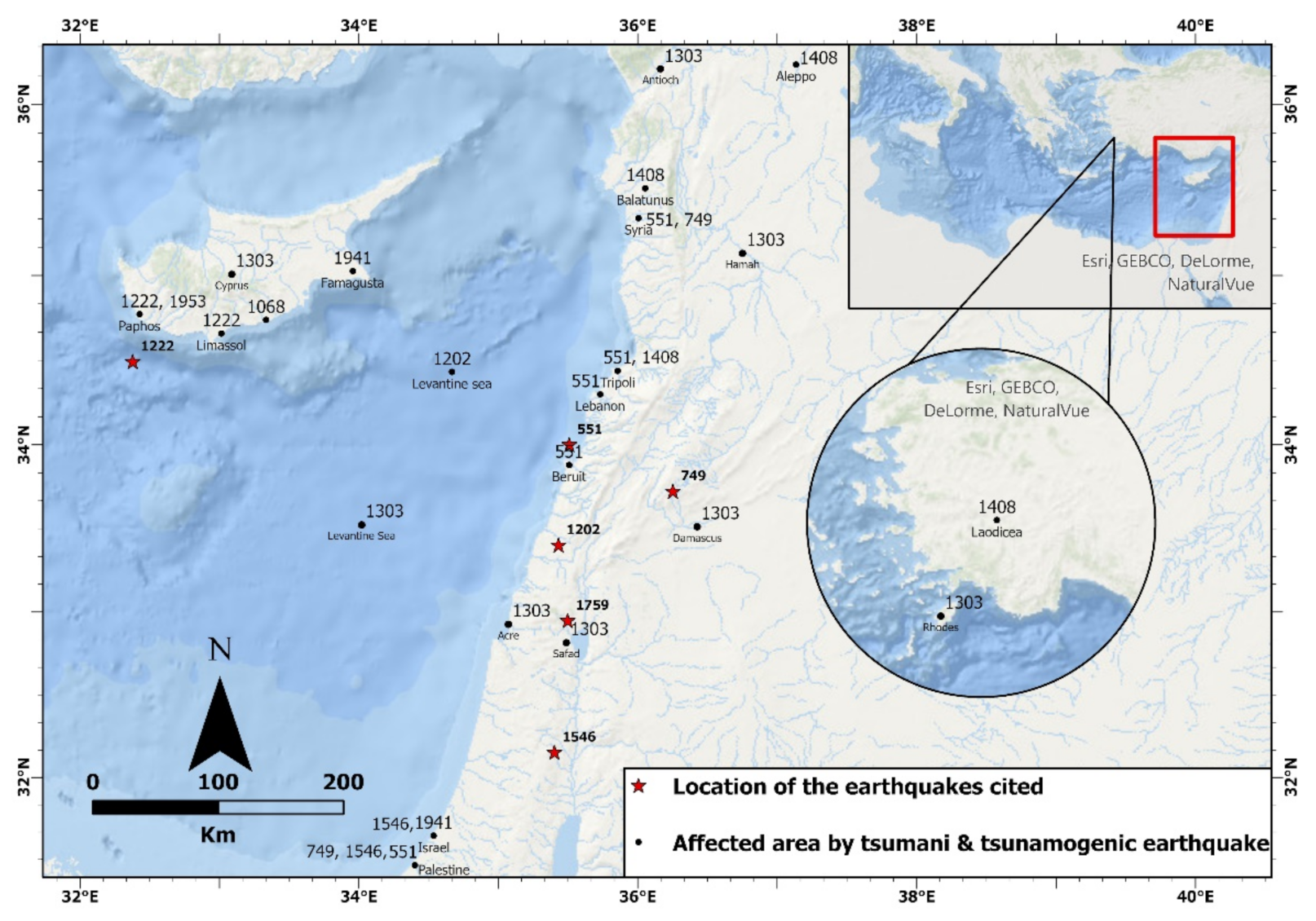
3. Historic Record of Tsunamis in Cyprus

The strongest tsunamis reported in the region of interest are those of 551 AD, 749, 1068, 1202, 1222, 1303, 1408, 1546 [72], and the modern tsunamis of 1941 and 1953, all occurring along the Levantine coast from Gaza northward (Figure 2). According to Salamon [73] and Papadopoulos et al. [74], in 551 AD, a sea retreat of more than a kilometer was recorded while ships were destroyed from the coast of Lebanon, Syria, and Palestine, with many references on the cities of Beirut and Tripoli. In 749 AD, an earthquake event was recorded followed by a tsunami at the coasts of Palestine, Jordan and Syria. The reported tsunami of 1068 has yet to be certified, as many studies have mentioned this event; however, they have not concluded on a specific earthquake source and date [44,45,72,73,75]. These earthquakes may have affected the southern coasts of Cyprus but without any particular record at the time as they may not have caused any disruption to human constructions. Consequently, in 1202 AD, in the Levantine Sea between Cyprus and Syria, a tsunami was recorded and referred to by many scientists [45,46,73,76,77]. Fokaefs and Papadopoulos [39] mentioned that the tsunami had an intensity of 7 and was triggered by an earthquake of M7.6 [75]. A possible cause of the tsunami could have been a submarine landslide following an inland earthquake [74] (Figure 2).
On the other hand, there have been tsunami occurrences far away that did not affect the Cyprus coastline. One of these tsunamis occurred around 1408 AD, and it was generated by a tremendous earthquake in the western part of Syria that caused damage mostly in the areas of Aleppo, Tripoli, Laodicea, Balatunus, and as far as Cyprus [72,73,75,78]. The intensity of the tsunamigenic earthquake was estimated as Ms = 7 by Ambraseys and Barazangi [79] (Figure 2).
In 1546, a sea retreat was recorded in southern Israel. According to studies [44,45,72], the sea withdrew from the coast of Palestine and a tsunami followed. However, there is no evidence of its origin. Probably, this tsunami was caused by a moderate-intensity earthquake Ms = 6 in the Jordan Valley, Israel [44,45,72,80,81,82]. However, this reported earthquake might not have been strong enough to produce a tsunami (Figure 2).
The latest catastrophic tsunami was in 1222. Waves were many meters high, and the earthquake and tsunami caused severe loss of life and widespread disasters in Paphos and Limassol. The city and the fortress of Paphos were flooded, and many fishes were found in the villages. A relevant description of the event was as follows: “The Paphos port left without water as the coastline moved to the sea” [39] (Figure 2).
The latest tsunami events in Cyprus were in 1941 and 1953. In 1941, a Ms = 6.5 earthquake in Famagusta (east Cyprus) caused a small earthquake tsunami which was observed off the coast of Israel and did not cause damage (Cyprus Geological Survey Department’s data). A very strong earthquake of Ms = 6.3, 9.1 km southwest of Paphos on Thursday, 10 September 1953 at 04:06 (GMT) caused tsunami waves around 1 m high. This small tsunami was seen along the coast of Paphos and did not cause any damage [39] (Figure 2).

4. Evidence of Palaeo-Tsunamis on the Coastal Zone of Cyprus

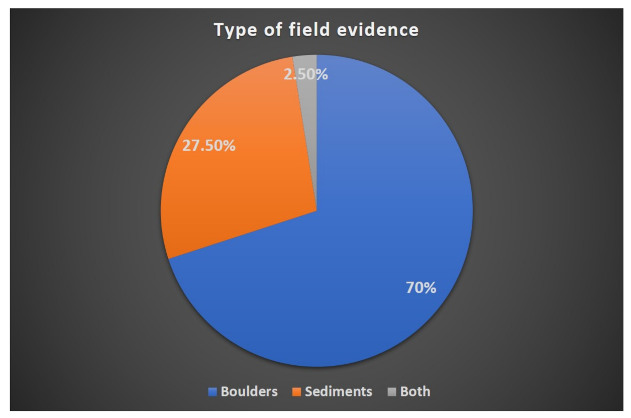
4.1. An Overview of Published Field Evidence

Although the study area has experienced tsunamis in the past and constitutes an area threatened by this hazard both from the Cyprean arc and from the neighboring Hellenic arc, field research on tsunami evidence on the coastal zone of Cyprus still remains scarce. Palaeo-tsunami deposits on the coasts of Cyprus were first reported by Kelletat and Schellmann [41] and Whelan and Kelletat [42] in 2002. Both studies reported field evidence from the west and southeast coasts of Cyprus in the form of boulders (Figure 3) and in the form of bands parallel to the coastline that were striped by soil or vegetation [41,42]. According to radiocarbon dating of marine organisms on dislocated boulders as well as relocated wood and charcoal from the west coasts [41], the coast of Cyprus were impacted by strong tsunamis around 1700–1750 AD. The aforementioned field data were later supplemented by Noller et al. [83], who provide further sites with field evidence of past tsunamis also from the north, northeast, south, and southeast coasts of the island; however, this evidence does not have any age constrains. A detailed field investigation on the southeast coast of Cyprus at Cape Greko by Evelpidou et al. [25] confirmed the existence of large, dislocated boulders, and radiocarbon dating on marine organisms revealed that the area was affected by the 1303 tsunami event but also by other extreme events that remain to be updated.
It is clear from the literature that large boulder accumulations are an important feature along the coasts of Cyprus, testifying to extreme events (see Supplementary Material). Although there is an abundance of field evidence, geochronological constrains are still scarce in the study area. In some coastal areas, the lithology of the boulders, i.e., calcarenites, makes the discovery of any datable material for radiocarbon difficult, such as the case of Cape Greko [25]. Recent attempts by Brill et al. [84] to use optically stimulated luminescence rock surface exposure dating (OSL-RSED) to estimate cliff-detachment ages of wave-transported coastal boulders of calcarenitic composition were also found to be unreliable due to low amounts of sensitive quartz and feldspar. Calcarenites are carbonate-dominated and/or carbonate-cemented sandstones which are predominantly >50% composed of carbonate grains. They can contain up to 50% non-carbonate grains such as quartz and feldspar, but they are not studied in depth with regard to occurrences on the Cyprus coastline. Additionally, waves and bio-erosion on boulder surfaces may affect the accuracy of the geochronological method applied [84].

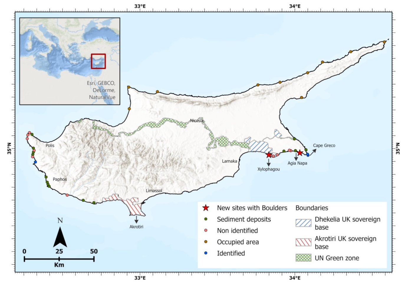
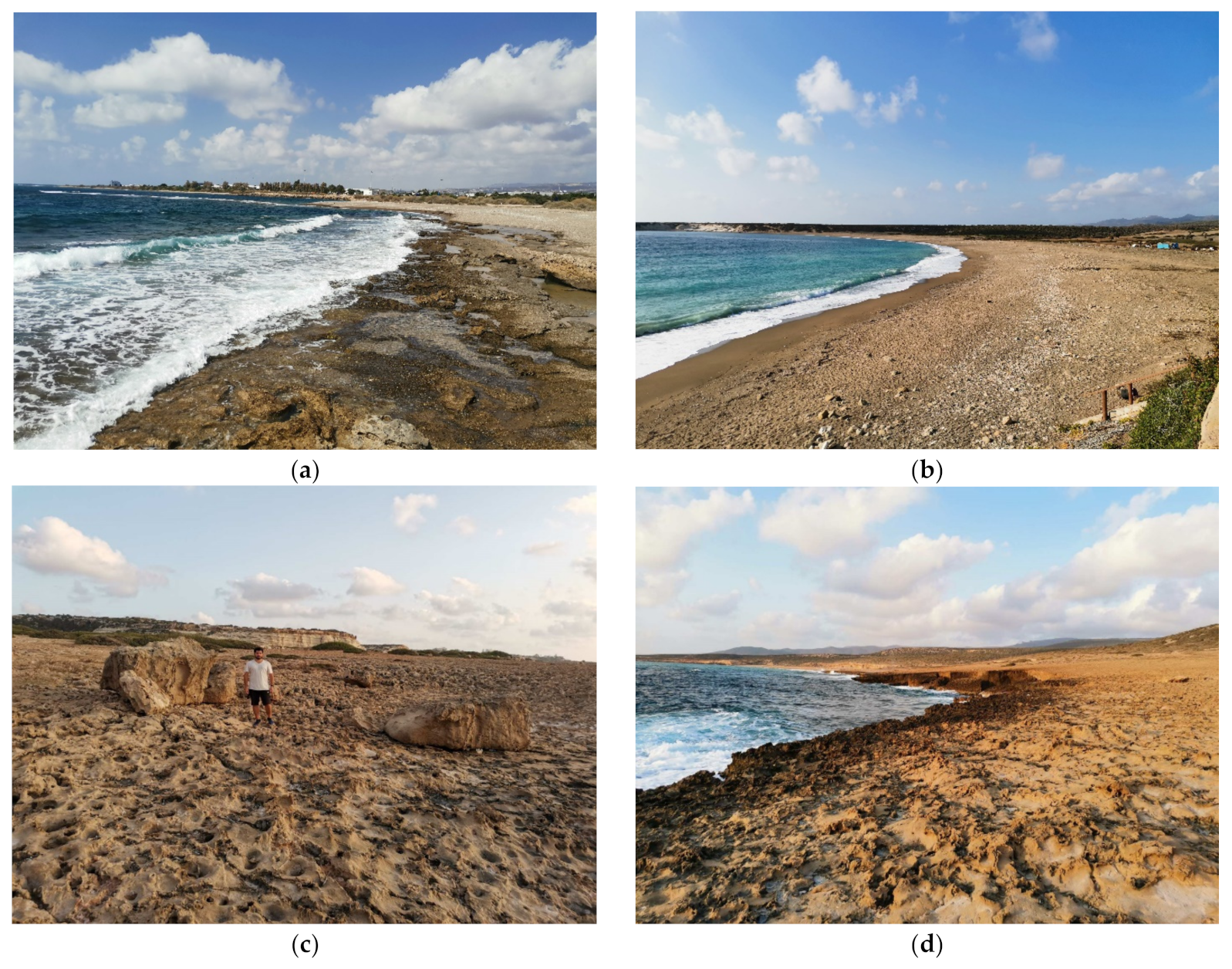
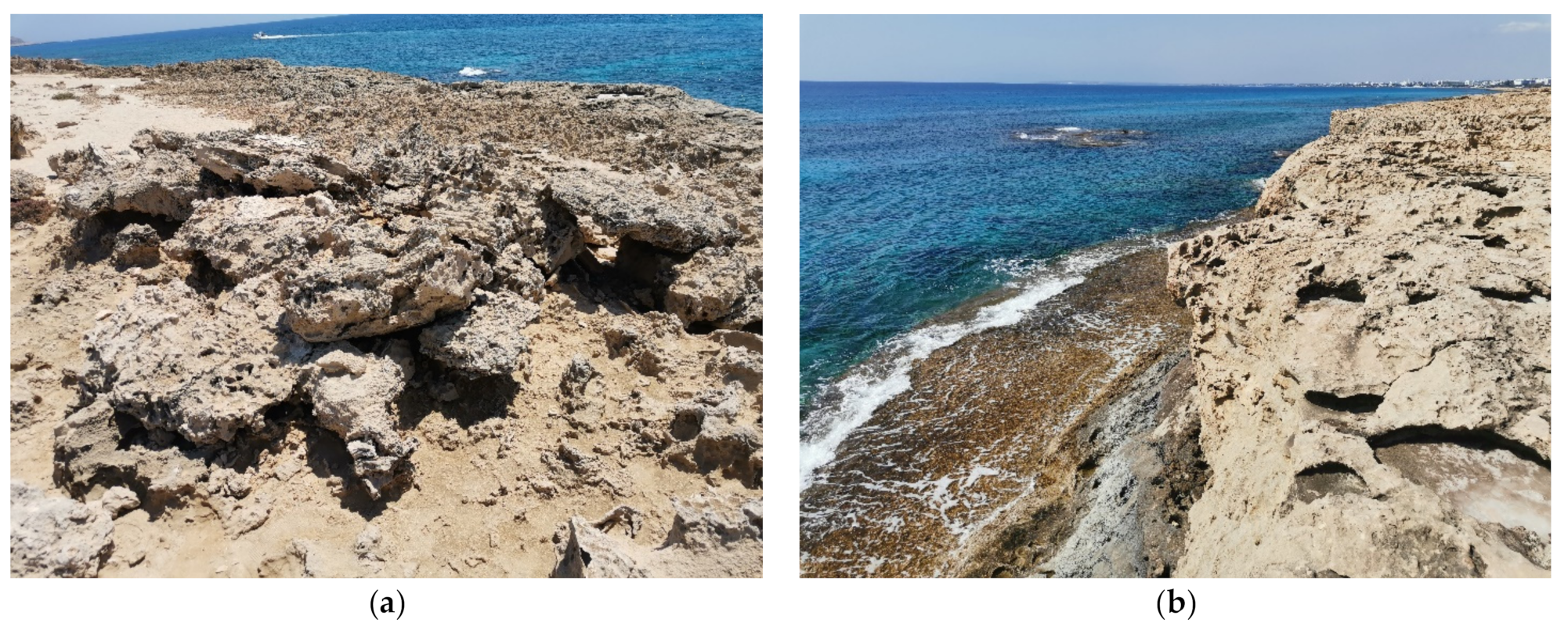
4.2. Survey Overview of Available Field Data

A detailed field survey was conducted by the authors during 2020. They visited and investigated sites that were reported in the available literature [6,42,81] for high-energy event deposits along the south coastline of Cyprus. The field survey was conducted in 19 coastal areas: Akamas Peninsula, Lara coast, Agios Georgios, Maniki coast, Kissonerga, Kato Paphos, Paphos Airport, Kouklia, Petra toy Romiou, Avdimou, Episkopi, Zygi-Maroni, Larnaka, Pyla cape, Ormidia, Xylophagou, Liopetri, Ayia Napa, and Protaras (see Supplementary Material for locations).
Through the survey, the authors were unable to identify any clear boulder accumulation or movement by tsunami in most of the aforementioned areas. On the rocky south coast of Cyprus, there was evidence of wave impact. However, most aforementioned sites were characterized by the absence of tsunami indicators. A possible explanation is that the high touristic activity that has been occurring on the coasts of Cyprus during the last 20 years may have affected tsunami indicators such as boulder accumulations. Nowadays, it is very difficult to have free access to the coast, as many locations are private.
On the other hand, on the west coast of Cyprus, one site of boulder accumulation was identified [42]. The site is located at the north-west Agios Georgios, Paphos (Figure 4c,d and Figure 5). The boulders have a maximum size of 1.5 m3. The rocky coast of Agios Georgios is characterized by a gentle seaward dip, highly erosional features (creep lines and karrens), and it is scraped of soil. Taking into account the geomorphology of the rocky coast and the fact that the area is highly affected by large waves, it is possible that these small boulder accumulations were dislocated because of a storm event.
Another identified boulder accumulation that indicates a high-energy wave event is located at Cape Greco, Ayia Napa (Figure 4e,f and Figure 5) [25]. The area is characterized by quite evident geomorphological features related to at least one tsunami event: a calcarenitic, rocky coast, scraped from soil, boulder deposits, two eroded platforms, boulder detachment zones, and karrens on the rocky coast. At that site, 272 boulders of various sizes were reported (Figure 4e,f) with a maximum volume of 24.7 m3 and a maximum height of 4 m a.m.s.l. [25].
As mentioned before, all the sites with boulder accumulation share similar geomorphological features: the deposition of boulders, imbricated clusters, detachment zones, eroded platforms, and rock shear zones. These features were not found at sites with non-identified boulders. This indicates a close relationship between the morphology of the coast and the accumulation of boulders (Figure 4). During the survey, the authors were unable to confirm tsunami sediment deposits reported by previous studies, e.g., tsunami deposits of 20 cm thickness located 3–4 km at the west of Petra tou Romiou [41,51,81]. The sediment deposit sites are indicated in the map of Figure 5 along with the unidentified boulder cases, as noted in the literature [6,42,81].

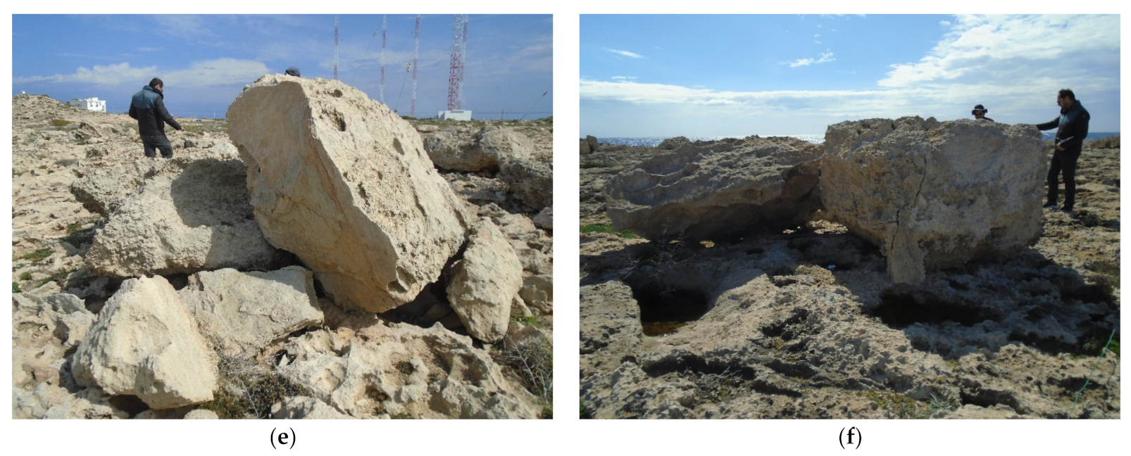
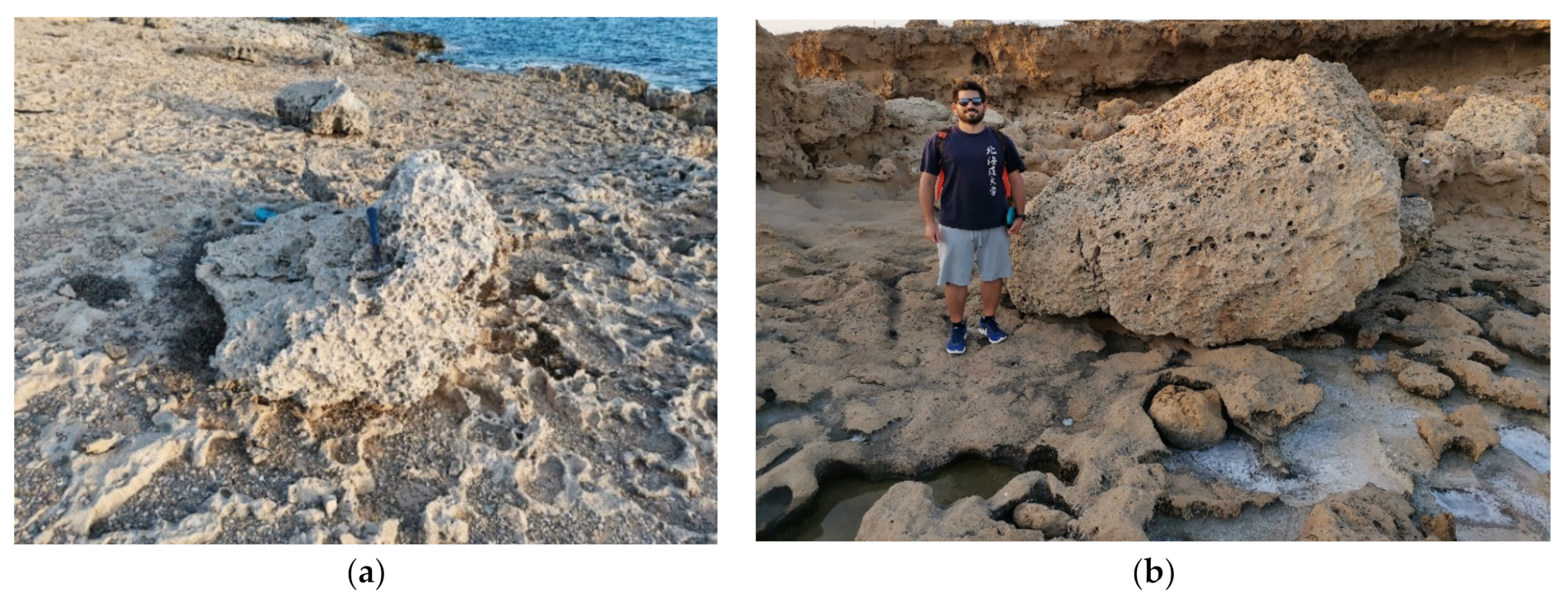
4.3. An Overview of New Field Data

The recent survey investigation conducted by the authors revealed two additional areas which have been affected by high-energy wave events, possibly tsunamis. The areas Xylophagou and Agia Napa are located on the southeastern part of Cyprus (Figure 5). Additionally, the authors conducted underwater photography and video in the Cape Greco area using a submarine drone in order to identify morphological features on the seabed, which can indicate a tsunami impact. In the submarine area south to Cape Greco, the seafloor is scraped of sediments and the vegetation is limited. Below the coastal platform, the seabed has a smooth inclination, which is abruptly interrupted by a vertical rocky step with a rectangle shape. The walls of the submerged rocks are also vertical with signs of intense wave carving. Moving deeper, in a distance of 20 m from the coastal platform, a second rocky vertical step was observed, which had evidence of an in situ boulder that has been detached from its main rock mass, but it was not moved from its initial place. Piloting the submarine drone towards the coast, drag lines were also visible. These lines indicate the movement of rock masses from/towards the coast.
The Xylophagou site shares similar geomorphological features to the Cape Greco site, with dislocated boulder accumulations lying on the coast. Six (6) boulders were identified, possibly originating from the subaerial platform (Figure 6). The boulders are located on the rocky coast at an altitude of 4 m above mean sea level (a.m.s.l.). During the investigation of the site, a layer of cemented pebbles was identified at a high elevation, above the aeolianite and the boulder deposits. This cemented layer may correspond to a palaeo-shoreline, suggesting an uplift of the area.
At the Ayia Napa site, ten (10) boulders were identified, whose original location is likely from the coastal platform (Figure 7). The site has similar features to the Cape Greco area. The boulders are located approximately 5 m a.m.s.l. on a high vertical cliff of aeolianite composition. They are located on the landward part of a wide eroded surface.

5. Warning System and Tsunami Risk for Cyprus Coasts

Within the Mediterranean, the tsunami hazards of Greece and Italy are ranked among the highest based on the tsunami records in contrast with the Cyprus–Levantine region, which is classified at the lowest level. Within this area, the Levantine coast is at much higher risk than Cyprus [39]. However, some of the damaging historical events highlight the need to evaluate tsunami hazards by all available means. Furthermore, remote tsunamigenic sources, such as those of 1303 with an earthquake epicenter in southern Cyprus [44,73,75] or 1481 in the eastern Hellenic arc, can pose a threat for the coastal zone of the Cyprus–Levantine area; hence, even these regional tsunamis should be considered in the evaluation of the tsunami risk of the region [39].
The average tsunami recurrence in the Cyprus–Levantine Sea region has been estimated to be around 30 years, 120 years, and 375 years for moderate (intensity > III), strong (intensity > V), and very strong (intensity > VIII) events, respectively [51,81]. The rate of tsunami occurrence equals 0.033, 8.3 × 10⁻³ and 2.7 × 10⁻³ events/year for intensity higher than III, V, and VIII, respectively [82].
The tsunami risk in Cyprus can come from three different sources:
  • Local, strong, submarine and surface earthquakes in the central part of the Cyprus arc (e.g., the earthquakes of 1222 and 1953). The Cyprian arc is subjected to subduction, collision, and transcurrent tectonic processes.
  • Submarine landslides on the Levantine coast, which are caused by strong earthquakes in the rift of the Dead Sea (e.g., the earthquake of 1202). Near the Levantine coast, the bottom is characterized by a steep slope, as well as east of Rhodes Island and south of the Cypriot shoreline, south from Paphos city.
  • Regional, strong, submarine and surface earthquakes in the Hellenic arc (e.g., the earthquakes of 1303 and 365). The tsunami potential in the Hellenic arc is the highest in the Mediterranean.
The latest strong tsunami that caused damage to the Cypriot coast was centuries ago, when the population and economic growth and development at the Cypriot shoreline did not exist. Today, the population of the coastal cities is more than 250,000, and the tourism in Cyprus reaches almost 4,000,000 visitors per year (according to the official Cyprus Government’s data). According the above, the impacts of a probable tsunami are maximized.
Although tsunamis are infrequent and they remain unpredictable, they are amongst the natural hazards with potential significant impact. Probabilistic hazard and risk analysis methods have been developed to aid in the preparation, mitigation, and prevention of potential losses from this natural hazard [71].
Most countries in the region have systems and procedures in place to warn residents in the case of a natural disaster. National systems commonly link to regional multi-hazard networks. Since 1965, the UNESCO Intergovernmental Oceanographic Commission (IOC) has been responsible for coordinating the Pacific Tsunami Warning System (PTWS). In June 2005, following the 26 December 2004 tsunami in the Indian Ocean, it was decided to set up three similar warning systems in the Indian Ocean, the Caribbean, and the North Atlantic and Mediterranean regions.
The Tsunami Service Providers (TSPs) of European countries for the Mediterranean region are: France, Turkey, Greece, Italy, and Portugal. These Service Providers may issue public messages for an ocean basin but only with a generic tsunami threat statement to avoid potential conflict and public confusion with the tsunami warnings issued by the National Tsunami Warning Centers (NTWCs). For this purpose, TSPs are continuously used throughout the year [16].
On 25 November 2016, the Council of Ministers approved the establishment of the Cyprus National Committee for NEAMTWS, coordinated from the Department of Geological Survey, members of the Civil Defense, and the Oceanographic Center of Cyprus University.
In Cyprus, as part of the operation of the NEAMTWS System, the Seismological Network of the Department of Geological Survey provides, in real time, continuous seismic data to the National Seismic Wave Warning Center of the Geodynamic Institute of the National Observatory of Athens and the Italian Center for Geophysics and Volcanology (INGV). In the case of a tsunami being detected, automatic warnings are sent to the Member States of the system. These alerts are received from local authorization centers (Civil Defense services for Cyprus), which activate national disaster response plans.

6. Concluding Remarks

An overview of bibliographically available information regarding tsunami evidence in Cyprus coastline is presented in this paper. New data were derived from extensive field work, which revealed additional locations of boulder accumulations that can be studied in detail in order to provide more data for palaeo-tsunami events in the Mediterranean. The source of the events in the region of the eastern Mediterranean appears to be connected mainly with strong local and regional surface and submarine earthquakes. The average tsunami recurrence in the Cyprus–Levantine Sea region appears to be around 30 years for moderate events, 120 years for strong events, and 375 years for very strong events.
From the recorded historical events, it is clear that this region of the Mediterranean has been constantly and continuously affected by tsunamis in the past. From the investigation and detailed study of past events, it is possible to obtain more data regarding the source of these events, to calculate the intensity, and provide a better estimation of the hazard, which will lead to the development of coastal management plans which will be focused on natural hazards.

Supplementary Materials

The data presented in Figure 5 are available at https://arcg.is/1eyXLO (accessed on 25 November 2021). A dashboard including a map along with statistics of the type of evidence may be found in the following link https://www.arcgis.com/apps/dashboards/3aca7dc81d604e2ab7171eb35cf9a9fa (accessed on 25 November 2021).

Author Contributions

Conceptualization, N.E.; formal analysis, N.E., A.K., M.P., G.S., and M.G.; investigation, N.E., A.K., A.K., M.P., and G.S; writing—original draft preparation, N.E, A.K., M.P., and G.S.; writing—review and editing, N.E., A.K., C.Z., C.S., C.R., A.K., M.P., and G.S.; visualization, M.T. All authors have read and agreed to the published version of the manuscript.

Funding

This research was funded by the MARIOLOPOULOS-KANAGINIS FOUNDATION.

Data Availability Statement

The data used in this study were derived from research articles. The database constructed for this work can be found at https://arcg.is/1eyXLO (accessed 25 November 2021).

Acknowledgments

The authors would like to thank the Mariolopoulos-Kanaginis Foundation for funding and supporting the activities of this research.

Conflicts of Interest

The authors declare no conflict of interest.

References

  1. Jankaew, K.; Atwater, B.F.; Sawai, Y.; Choowong, M.; Charoentitirat, T.; Martin, M.E.; Prendergast, A. Medieval forewarning of the 2004 Indian Ocean tsunami in Thailand. Nature 2008, 455, 1228–1231. [Google Scholar] [CrossRef]
  2. Horton, B.P.; Rossi, V.; Hawkes, A.D. The sedimentary record of the 2005 hurricane season from the Mississippi and Alabama coastlines. Quat. Int. 2009, 195, 15–30. [Google Scholar] [CrossRef]
  3. Liu, W.; Yamazaki, F.; Gokon, H.; Koshimura, S. Extraction of Tsunami-Flooded Areas and Damaged Buildings in the 2011 Tohoku-Oki Earthquake from TerraSAR-X Intensity Images. Earthq. Spectra 2013, 29, 183–200. [Google Scholar] [CrossRef] [Green Version]
  4. Dawson, A.; Shi, S. Tsunami Deposits. Pure Appl. Geophys. 2000, 157, 875–897. [Google Scholar] [CrossRef]
  5. Gelfenbaum, G.; Jaffe, B. Erosion and Sedimentation from the 17 July, 1998 Papua New Guinea Tsunami. Pure Appl. Geophys. 2003, 160, 1969–1999. [Google Scholar] [CrossRef]
  6. Scheffers, A.; Kelletat, D. Sedimentologic and geomorphologic tsunami imprints worldwide—A review. Earth-Sci. Rev. 2003, 63, 83–92. [Google Scholar] [CrossRef]
  7. Goff, J.; Chagué-Goff, C.; Nichol, S.; Jaffe, B.; Dominey-Howes, D. Progress in palaeotsunami research. Sediment. Geol. 2012, 243–244, 70–88. [Google Scholar] [CrossRef]
  8. England, P.; Howell, A.; Jackson, J.; Synolakis, C. Palaeotsunamis and tsunami hazards in the Eastern Mediterranean. Philos. Trans. R. Soc. A Math. Phys. Eng. Sci. 2015, 373, 20140374. [Google Scholar] [CrossRef] [Green Version]
  9. Marriner, N.; Kaniewski, D.; Morhange, C.; Flaux, C.; Giaime, M.; Vacchi, M.; Goff, J. Tsunamis in the geological record: Making waves with a cautionary tale from the Mediterranean. Sci. Adv. 2017, 3, e1700485. [Google Scholar] [CrossRef] [Green Version]
  10. Sugawara, D. Lessons from the 2011 Tohoku-oki tsunami: Implications for Paleotsunami research. In Tsunamiites; Elsevier: Amsterdam, The Netherlands, 2021; pp. 155–181. [Google Scholar] [CrossRef]
  11. Marriner, N.; Morhange, C.; Skrimshire, S. Geoscience meets the four horsemen? Tracking the rise of neocatastrophism. Glob. Planet. Chang. 2010, 74, 43–48. [Google Scholar] [CrossRef]
  12. Paris, R.; Fournier, J.; Poizot, E.; Etienne, S.; Morin, J.; Lavigne, F.; Wassmer, P. Boulder and fine sediment transport and deposition by the 2004 tsunami in Lhok Nga (western Banda Aceh, Sumatra, Indonesia): A coupled offshore–onshore model. Mar. Geol. 2010, 268, 43–54. [Google Scholar] [CrossRef]
  13. Ozawa, S.; Nishimura, T.; Suito, H.; Kobayashi, T.; Tobita, M.; Imakiire, T. Coseismic and postseismic slip of the 2011 magnitude-9 Tohoku-Oki earthquake. Nature 2011, 475, 373–377. [Google Scholar] [CrossRef] [PubMed]
  14. Goto, K.; Chagué-Goff, C.; Fujino, S.; Goff, J.; Jaffe, B.; Nishimura, Y.; Richmond, B.; Sugawara, D.; Szczuciński, W.; Tappin, D.R.; et al. New insights of tsunami hazard from the 2011 Tohoku-oki event. Mar. Geol. 2011, 290, 46–50. [Google Scholar] [CrossRef]
  15. Mori, N.; Takahashi, T.; Hamaura, S.E.; Miyakawa, K.; Tanabe, K.; Tanaka, K.; Tanaka, M.; Watanabe, T.; Matsutomi, H.; Naoe, K.; et al. Nationwide post event survey and analysis of the 2011 Tohoku earthquake tsunami. Coast. Eng. J. 2014, 54, 1250001-1–1250001-27. [Google Scholar] [CrossRef] [Green Version]
  16. Hayashi, S.; Koshimura, S. The 2011 Tohoku tsunami flow velocity estimation by the aerial video analysis and numerical modeling. J. Disaster Res. 2013, 8, 561–572. [Google Scholar] [CrossRef]
  17. Makinoshima, F.; Oishi, Y.; Yamazaki, T.; Furumura, T.; Imamura, F. Early forecasting of tsunami inundation from tsunami and geodetic observation data with convolutional neural networks. Nat. Commun. 2021, 12, 2253. [Google Scholar] [CrossRef]
  18. Kempf, P.; Moernaut, J.; Van Daele, M.; Pino, M.; Urrutia, R.; De Batist, M. Paleotsunami record of the past 4300 years in the complex coastal lake system of Lake Cucao, Chiloé Island, south central Chile. Sediment. Geol. 2020, 401, 105644. [Google Scholar] [CrossRef] [Green Version]
  19. Lespez, L.; Lescure, S.; Saulnier-Copard, S.; Glais, A.; Berger, J.-F.; Lavigne, F.; Pearson, C.; Virmoux, C.; Müller Celka, S.; Pomadère, M. Discovery of a tsunami deposit from the Bronze Age Santorini eruption at Malia (Crete): Impact, chronology, extension. Sci. Rep. 2021, 11, 15487. [Google Scholar] [CrossRef]
  20. Scardino, G.; Rizzo, A.; De Santis, V.; Kyriakoudi, D.; Rovere, A.; Vacchi, M.; Torrisi, S.; Scicchitano, G. Insights on the origin of multiple tsunami events affected the archaeological site of Ognina (south-eastern Sicily, Italy). Quat. Int. 2021. [Google Scholar] [CrossRef]
  21. Vacchi, M.; Rovere, A.; Zouros, N.; Firpo, M. Assessing enigmatic boulder deposits in NE Aegean Sea: Importance of historical sources as tool to support hydrodynamic equations. Nat. Hazards Earth Syst. Sci. 2012, 12, 1109–1118. [Google Scholar] [CrossRef] [Green Version]
  22. Boulton, S.J.; Whitworth, M.R.Z. Block and boulder accumulations on the southern coast of Crete (Greece): Evidence for the 365 CE tsunami in the Eastern Mediterranean. In Tsunamis: Geology, Hazards and Risks; Chapman, N.A., Tappin, D.R., Wallis, S.R., Eds.; The Geological Society of London: London, UK, 2017. [Google Scholar]
  23. Haslett, S.K.; Wong, B.R. Reconnaissance survey of coastal boulders in the moro gulf (Philippines) using google earth imagery: Initial insights into celebes sea tsunami events. Bull. Geol. Soc. Malays. 2019, 68, 37–44. [Google Scholar] [CrossRef] [Green Version]
  24. Roig-Munar, F.X.; Rodríguez-Perea, A.; Vilaplana, J.M.; Martín-Prieto, J.A.; Gelabert, B. Tsunami boulders in Majorca Island (Balearic Islands, Spain). Geomorphology 2019, 334, 76–90. [Google Scholar] [CrossRef]
  25. Evelpidou, N.; Zerefos, C.; Synolakis, C.; Repapis, C.; Karkani, A.; Polidorou, M.; Saitis, G. Coastal Boulders on the SE Coasts of Cyprus as Evidence of Palaeo-Tsunami Events. J. Mar. Sci. Eng. 2020, 8, 812. [Google Scholar] [CrossRef]
  26. Tuttle, M.P.; Ruffman, A.; Anderson, T.; Jeter, H. Distinguishing Tsunami from Storm Deposits in Eastern North America: The 1929 Grand Banks Tsunami versus the 1991 Halloween Storm. Seismol. Res. Lett. 2004, 75, 117–131. [Google Scholar] [CrossRef]
  27. Dominey-Howes, D.T.M.; Humphreys, G.S.; Hesse, P.P. Tsunami and palaeotsunami depositional signatures and their potential value in understanding the late-Holocene tsunami record. Holocene 2006, 16, 1095–1107. [Google Scholar] [CrossRef]
  28. Switzer, A.D.; Jones, B.G. Large-scale washover sedimentation in a freshwater lagoon from the southeast Australian coast: Sea-level change, tsunami or exceptionally large storm? Holocene 2008, 18, 787–803. [Google Scholar] [CrossRef]
  29. Engel, M.; Brückner, H. The identification of palaeo-tsunami deposits—A major challenge in coastal sedimentary research. Coastline Rep. 2011, 17, 65–80. [Google Scholar]
  30. Scheffers, A.; Kelletat, D.; Haslett, S.; Scheffers, S.; Browne, T. Coastal boulder deposits in Galway Bay and the Aran Islands, western Ireland. Z. Geomorphol. 2010, 54, 247–279. [Google Scholar] [CrossRef]
  31. Kortekaas, S.; Dawson, A.G. Distinguishing tsunami and storm deposits: An example from Martinhal, SW Portugal. Sediment. Geol. 2007, 200, 208–221. [Google Scholar] [CrossRef]
  32. Nott, J. Waves, coastal boulder deposits and the importance of the pre-transport setting. Earth Planet. Sci. Lett. 2003, 210, 269–276. [Google Scholar] [CrossRef]
  33. Pignatelli, C.; Sansò, P.; Mastronuzzi, G. Evaluation of tsunami flooding using geomorphologic evidence. Mar. Geol. 2009, 260, 6–18. [Google Scholar] [CrossRef]
  34. Benner, R.; Browne, T.; Bruckner, H.; Kelletat, D.; Scheffers, A. Boulder Transport by Waves: Progress in Physical Modelling. Z. Geomorphol. 2010, 54, 127–146. [Google Scholar] [CrossRef]
  35. Barbano, M.S.; Pirrotta, C.; Gerardi, F. Large boulders along the south-eastern Ionian coast of Sicily: Storm or tsunami deposits? Mar. Geol. 2010, 275, 140–154. [Google Scholar] [CrossRef]
  36. Engel, M.; May, S.M. Bonaire’s boulder fields revisited: Evidence for Holocene tsunami impact on the Leeward Antilles. Quat. Sci. Rev. 2012, 54, 126–141. [Google Scholar] [CrossRef]
  37. Nandasena, N.A.K.; Tanaka, N.; Sasaki, Y.; Osada, M. Boulder transport by the 2011 Great East Japan tsunami: Comprehensive field observations and whither model predictions? Mar. Geol. 2013, 346, 292–309. [Google Scholar] [CrossRef]
  38. Oetjen, J.; Engel, M.; Pudasaini, S.P.; Schuettrumpf, H. Significance of boulder shape, shoreline configuration and pre-transport setting for the transport of boulders by tsunamis. Earth Surf. Process. Landf. 2020, 2133, 2118–2133. [Google Scholar] [CrossRef] [Green Version]
  39. Fokaefs, A.; Papadopoulos, G.A. Tsunami hazard in the Eastern Mediterranean: Strong earthquakes and tsunamis in Cyprus and the Levantine Sea. Nat. Hazards 2007, 40, 503–526. [Google Scholar] [CrossRef]
  40. Ambraseys, N.; Synolakis, C. Tsunami Catalogs for the Eastern Mediterranean, Revisited. J. Earthq. Eng. 2010, 14, 309–330. [Google Scholar] [CrossRef]
  41. Kelletat, D.; Schellmann, G. Tsunamis on Cyprus: Field evidences and 14C dating results. Z. Geomorphol. 2002, 46, 19–34. [Google Scholar] [CrossRef]
  42. Whelan, F.; Kelletat, D. Geomorphic evidence and relative and absolute dating: Results for tsunami events on Cyprus. Sci. Tsunami Hazards 2002, 20, 3–18. [Google Scholar]
  43. Ambraseys, N.N.; Adams, R.D. Seismicity of the Cyprus region. Terra Nov. 1993, 5, 85–94. [Google Scholar] [CrossRef]
  44. Ambraseys, N.N.; Melville, C.P.; Adams, R. The Seismicity of Egypt, Arabia and the Red Sea; Cambridge University Press: Cambridge, UK, 1994. [Google Scholar]
  45. Amiran, R.; Arieh, E.; Turcotte, T. Earthquakes in Israel and Adjacent Areas: Observations. Isr. Explor. J. 1994, 44, 260–305. [Google Scholar] [CrossRef]
  46. Soloviev, S.L.; Solovieva, O.N.; Go, C.N.; Kim, K.S.; Shchetnikov, N.A. Tsunamis in the Mediterranean Sea 2000 B.C.–2000 A.D.; Bonnin, J., Levin, B.W., Tinti, S., Papadopoulos, G.A., Eds.; Advances in Natural and Technological Hazards Research; Springer: Dordrecht, The Netherlands, 2000; Volume 13, ISBN 978-90-481-5557-6. [Google Scholar]
  47. Soren, D. University of Arizona excavations at Kourion, Cyprus. Am. J. Archaeol. 1988, 92, 265. [Google Scholar]
  48. Christou, D. Kourion: Its Monuments and Local Museum; Filokipros: Nicosia, Cyprus, 1996. [Google Scholar]
  49. Guidoboni, E.; Comastri, A.; Traina, G. Catalogue of Ancient Earthquakes in the Mediterranean Area Up to the 10th Century; Istituto Nazionale di Geofisica: Rome, Italy, 1994. [Google Scholar]
  50. Evagelatou-Notara, F. Earthquakes in Byzantium from 13th to 15th century—A historical examination. Parous. Athens 1993, 24, 1–179. [Google Scholar]
  51. Noller, J.; Panayides, I.; Zomeni, Z. Report on the Preliminary Assessment of Tsunami Hazard in Cyprus; Geological Survey Department: Lefkosia, Cyprus, 2005.
  52. Yolsal, S.; Taymaz, T.; Yalçiner, A.C. Understanding tsunamis, potential source regions and tsunami-prone mechanisms in the Eastern Mediterranean. Geol. Soc. Lond. Spec. Publ. 2007, 291, 201–230. [Google Scholar] [CrossRef]
  53. Makris, J.; Stobbe, C. Physical properties and state of the crust and upper mantle of the Eastern Mediterranean Sea deduced from geophysical data. Mar. Geol. 1984, 55, 347–363. [Google Scholar] [CrossRef]
  54. Taymaz, T.; Jackson, J.; Mckenzie, D.; McKenzie, D.; Taymaz, T.; Jackson, J.; McKenzie, D. Active tectonics of the north and central Aegean Sea. Geophys. J. Int. 1991, 106, 433–490. [Google Scholar] [CrossRef]
  55. Ten Veen, J.H.; Woodside, J.M.; Zitter, T.A.C.; Dumont, J.F.; Mascle, J.; Volkonskaia, A. Neotectonic evolution of the Anaximander Mountains at the junction of the Hellenic and Cyprus arcs. Tectonophysics 2004, 391, 35–65. [Google Scholar] [CrossRef]
  56. Reilinger, R.; McClusky, S.; Vernant, P.; Lawrence, S.; Ergintav, S.; Cakmak, R.; Ozener, H.; Kadirov, F.; Guliev, I.; Stepanyan, R.; et al. GPS constraints on continental deformation in the Africa-Arabia-Eurasia continental collision zone and implications for the dynamics of plate interactions. J. Geophys. Res. Solid Earth 2006, 111. [Google Scholar] [CrossRef]
  57. McPhee, P.J.; van Hinsbergen, D.J.J. Tectonic reconstruction of Cyprus reveals Late Miocene continental collision of Africa and Anatolia. Gondwana Res. 2019, 68, 158–173. [Google Scholar] [CrossRef]
  58. Vidal, N.; Alvarez-Marrón, J.; Klaeschen, D. The structure of the Africa-Anatolia plate boundary in the eastern Mediterranean. Tectonics 2000, 19, 723–739. [Google Scholar] [CrossRef]
  59. Calon, T.J.; Aksu, A.E.; Hall, J. The Neogene evolution of the Outer Latakia Basin and its extension into the Eastern Mesaoria Basin (Cyprus), Eastern Mediterranean. Mar. Geol. 2005, 221, 61–94. [Google Scholar] [CrossRef]
  60. Symeou, V.; Homberg, C.; Nader, F.H.; Darnault, R.; Lecomte, J.C.; Papadimitriou, N. Longitudinal and Temporal Evolution of the Tectonic Style Along the Cyprus Arc System, Assessed Through 2-D Reflection Seismic Interpretation. Tectonics 2018, 37, 30–47. [Google Scholar] [CrossRef] [Green Version]
  61. Selva, J.; Amato, A.; Armigliato, A.; Basili, R.; Bernardi, F.; Brizuela, B.; Cerminara, M.; de’ Micheli Vitturi, M.; Di Bucci, D.; Di Manna, P.; et al. Tsunami risk management for crustal earthquakes and non-seismic sources in Italy. Riv. Nuovo Cim. 2021, 44, 69–144. [Google Scholar] [CrossRef]
  62. Basili, R.; Tiberti, M.M.; Kastelic, V.; Romano, F.; Piatanesi, A.; Selva, J.; Lorito, S. Integrating geologic fault data into tsunami hazard studies. Nat. Hazards Earth Syst. Sci. 2013, 13, 1025–1050. [Google Scholar] [CrossRef] [Green Version]
  63. Tinti, S.; Bortolucci, E.; Armigliato, A. Numerical simulation of the landslide-induced tsunami of 1988 on Vulcano Island, Italy. Bull. Volcanol. 1999, 61, 121–137. [Google Scholar] [CrossRef]
  64. Tinti, S.; Chiocci, F.L.; Zaniboni, F.; Pagnoni, G.; de Alteriis, G. Numerical simulation of the tsunami generated by a past catastrophic landslide on the volcanic island of Ischia, Italy. Mar. Geophys. Res. 2010, 32, 287–297. [Google Scholar] [CrossRef]
  65. Chiocci, F.L.; de Alteriis, G. The Ischia debris avalanche: First clear submarine evidence in the Mediterranean of a volcanic island prehistorical collapse. Terra Nov. 2006, 18, 202–209. [Google Scholar] [CrossRef]
  66. Zaniboni, F.; Pagnoni, G.; Tinti, S.; Della Seta, M.; Fredi, P.; Marotta, E.; Orsi, G. The potential failure of Monte Nuovo at Ischia Island (Southern Italy): Numerical assessment of a likely induced tsunami and its effects on a densely inhabited area. Bull. Volcanol. 2013, 75, 763. [Google Scholar] [CrossRef]
  67. Pistolesi, M.; Bertagnini, A.; Di Roberto, A.; Ripepe, M.; Rosi, M. Tsunami and tephra deposits record interactions between past eruptive activity and landslides at Stromboli volcano, Italy. Geology 2020, 48, 436–440. [Google Scholar] [CrossRef]
  68. Maramai, A.; Brizuela, B.; Graziani, L. The Euro-Mediterranean Tsunami Catalogue. Ann. Geophys. 2014, 57, S0435. [Google Scholar] [CrossRef]
  69. Dogan, G.G.; Annunziato, A.; Papadopoulos, G.A.; Guler, H.G.; Yalciner, A.C.; Cakir, T.E.; Sozdinler, C.O.; Ulutas, E.; Arikawa, T.; Suzen, M.L.; et al. The 20th July 2017 Bodrum–Kos Tsunami Field Survey. Pure Appl. Geophys. 2019, 176, 2925–2949. [Google Scholar] [CrossRef]
  70. Selva, J.; Tonini, R.; Molinari, I.; Tiberti, M.M.; Romano, F.; Grezio, A.; Melini, D.; Piatanesi, A.; Basili, R.; Lorito, S. Quantification of source uncertainties in Seismic Probabilistic Tsunami Hazard Analysis (SPTHA). Geophys. J. Int. 2016, 205, 1780–1803. [Google Scholar] [CrossRef] [Green Version]
  71. Basili, R.; Brizuela, B.; Herrero, A.; Iqbal, S.; Lorito, S.; Maesano, F.E.; Murphy, S.; Perfetti, P.; Romano, F.; Scala, A.; et al. The Making of the NEAM Tsunami Hazard Model 2018 (NEAMTHM18). Front. Earth Sci. 2021, 8, 753. [Google Scholar] [CrossRef]
  72. Ambraseys, N. Earthquakes in the Eastern Mediterranean and the Middle East; Cambridge University Press: New York, NY, USA, 2009; ISBN 9780521872928. [Google Scholar]
  73. Salamon, A.; Rockwell, T.; Guidoboni, E.; Comastri, A. A critical evaluation of tsunami records reported for the Levant coast from the second millennium BCE to the present. Isr. J. Earth Sci. 2009, 58, 327–354. [Google Scholar] [CrossRef]
  74. Papadopoulos, G.A.; Gràcia, E.; Urgeles, R.; Sallares, V.; De Martini, P.M.; Pantosti, D.; González, M.; Yalciner, A.C.; Mascle, J.; Sakellariou, D.; et al. Historical and pre-historical tsunamis in the Mediterranean and its connected seas: Geological signatures, generation mechanisms and coastal impacts. Mar. Geol. 2014, 354, 81–109. [Google Scholar] [CrossRef]
  75. Guidoboni, E.; Comastri, A. Catalogue of Earthquakes and Tsunamis in the Mediterranean Area from the 11th to the 15th Century; Istituto Nazionale di Geofisica e Vulcanologia: Rome, Italy, 2005; p. 1037.
  76. Shalem, N. Seismic tidal waves (tsunamis) in the Eastern Mediterranean. Soc. Explor. Eretz Isr. 1956, 20, 159–170. [Google Scholar]
  77. Ambraseys, N.N. Data for the investigation of the seismic sea-waves in the Eastern Mediterranean. Bull. Seismol. Soc. Am. 1962, 52, 895–913. [Google Scholar]
  78. Ambraseys, N.N.; Jackson, J.A. Faulting associated with historical and recent earthquakes in the Eastern Mediterranean region. Geophys. J. Int. 1998, 133, 390–406. [Google Scholar] [CrossRef] [Green Version]
  79. Ambraseys, N.N.; Barazangi, M. The 1759 Earthquake in the Bekaa Valley: Implications for earthquake hazard assessment in the Eastern Mediterranean Region. J. Geophys. Res. Solid Earth 1989, 94, 4007–4013. [Google Scholar] [CrossRef] [Green Version]
  80. Ambraseys, N.; Karcz, I. The earthquake of 1546 in the Holy Landz. Terra Nov. 1992, 4, 254–263. [Google Scholar] [CrossRef]
  81. Noller, J.S.; Zomeni, Z.; Panayides, I. Preliminary field and GIS-based assessment of tsunami hazard on Cyprus. CIESM Work. Monogr. 2011, 42, 49–58. [Google Scholar]
  82. Cyprus Civil Defence Department, Ministry of Interior. 2nd Report on the National Risk Assessment of the Republic of Cyprus; Ministry of Interior, Cyprus Civil Defence: Nicosia, Cyprus, 2016.
  83. Noller, J.S.; Zomeni, Z.; Panayides, I. Marine geo-hazards in the Mediterranean. CIESM Work. Monogr. 2011, 42, 49–58. [Google Scholar]
  84. Brill, D.; May, S.M.; Mhammdi, N.; King, G.; Burow, C.; Wolf, D.; Zander, A.; Lehmann, B.; Brückner, H. OSL rock surface exposure dating as a novel approach for reconstructing transport histories of coastal boulders over decadal to centennial timescales. Earth Surf. Dynam. 2021, 9, 205–234. [Google Scholar] [CrossRef]
Figure 1. Location and geotectonic setting of Cyprus (PTZ: Paphos Transform Fault; DSF: Dead Sea Fault; M-KFZ: Misis–Kyrenia Fault Zone; OFZ: Ovgos Fault).
Geosciences 12 00058 g001
Figure 2. Location of reported historical earthquakes and areas affected by tsunami or tsunamigenic earthquakes.
Geosciences 12 00058 g002
Figure 3. An overview of published work on palaeo-tsunamis in Cyprus shows that the main indicators used are boulders, while sediments have been reported less frequently.
Geosciences 12 00058 g003
Figure 4. Example of sites of south Cyprus. In most cases, there is an absence of evidence of high-energy event deposits as mentioned in the literature: (a) Paphos airport area with a beachrock formation. Beachrocks may create flattened boulders as they break from the wave action; (b) Lara coast with no high-energy event deposits available. Confirmed evidence of high-energy event: (c) 4 identified boulder deposits at Agios Georgios, Pathos; (d) general view of Agios Georgios, Pathos rocky coast. (e,f) Boulders at Cape Greko, Cyprus, lying at about 4.5 m above sea level. According to Evelpidou et al. [25], their geomorphic characteristics suggest that their current location is owed to at least one tsunami event.
Geosciences 12 00058 g004aGeosciences 12 00058 g004b
Figure 5. Μap of Cyprus with all possible tsunami occurrences in the literature. Boulder deposits and sediment deposits cases are mentioned. The red stars indicate the newly identified areas, identified by the authors. The data presented in this map are available at https://arcg.is/1eyXLO (accessed on 26 November 2020).
Geosciences 12 00058 g005
Figure 6. Boulders at Xylophagou, Cyprus. Their characteristics indicate that their current location is owed to at least one tsunami event. (a) Two boulders lying at about 4 m a.m.s.l. with a mean size of 0.6 m3. (b) A boulder sized 2 m3 lying at about 0.5 m a.m.s.l. on a wavecut plateau.
Geosciences 12 00058 g006
Figure 7. Boulders at Ayia Napa lying at about 5 m a.m.s.l. on a coastal cliff. Their geomorphological characteristics indicate that their present location is also owed to at least one tsunami event. (a) Boulder clusters with a mean size of 0.5 m3; (b) a 4 m high vertical cliff at Ayia Napa site.
Geosciences 12 00058 g007
Publisher’s Note: MDPI stays neutral with regard to jurisdictional claims in published maps and institutional affiliations.

