
Stratigraphic and Tectonic Setting of the Liguride Units Cropping Out along the Southeastern Side of the Agri Valley (Southern Apennines, Italy)


Abstract
1. Introduction
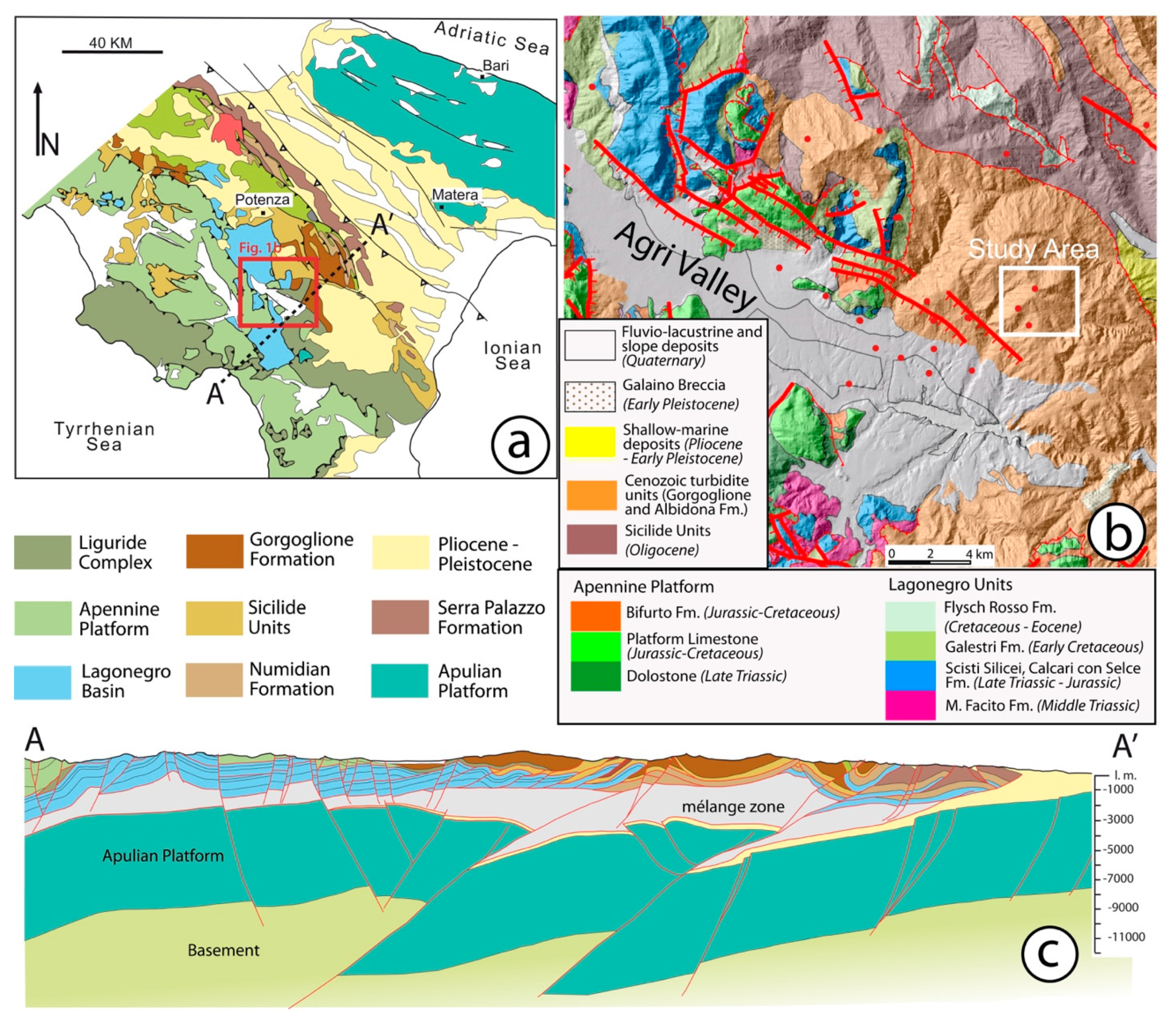
2. Geological Setting
3. The Age and Significance of the Albidona Formation
4. Data and Methods
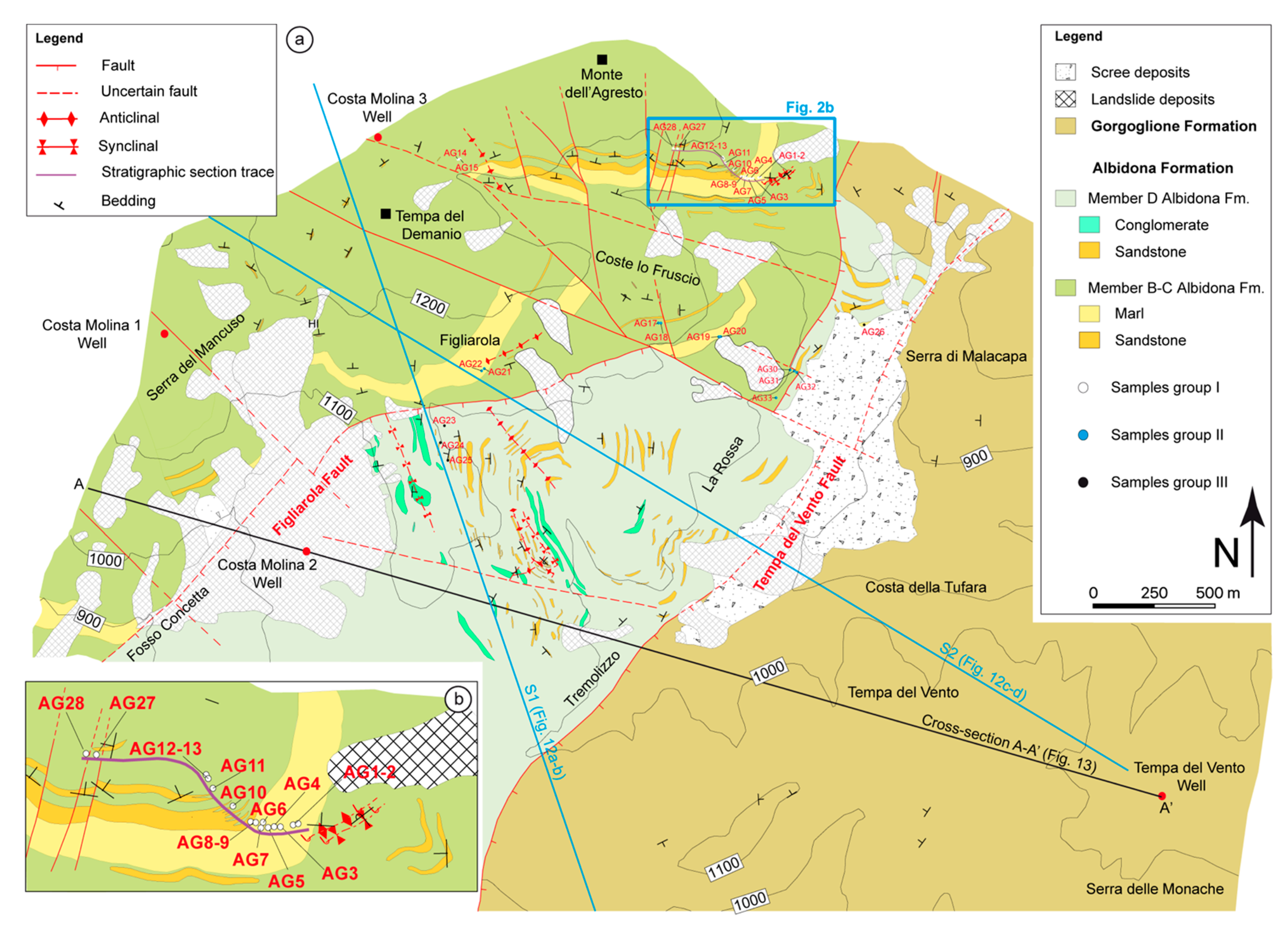
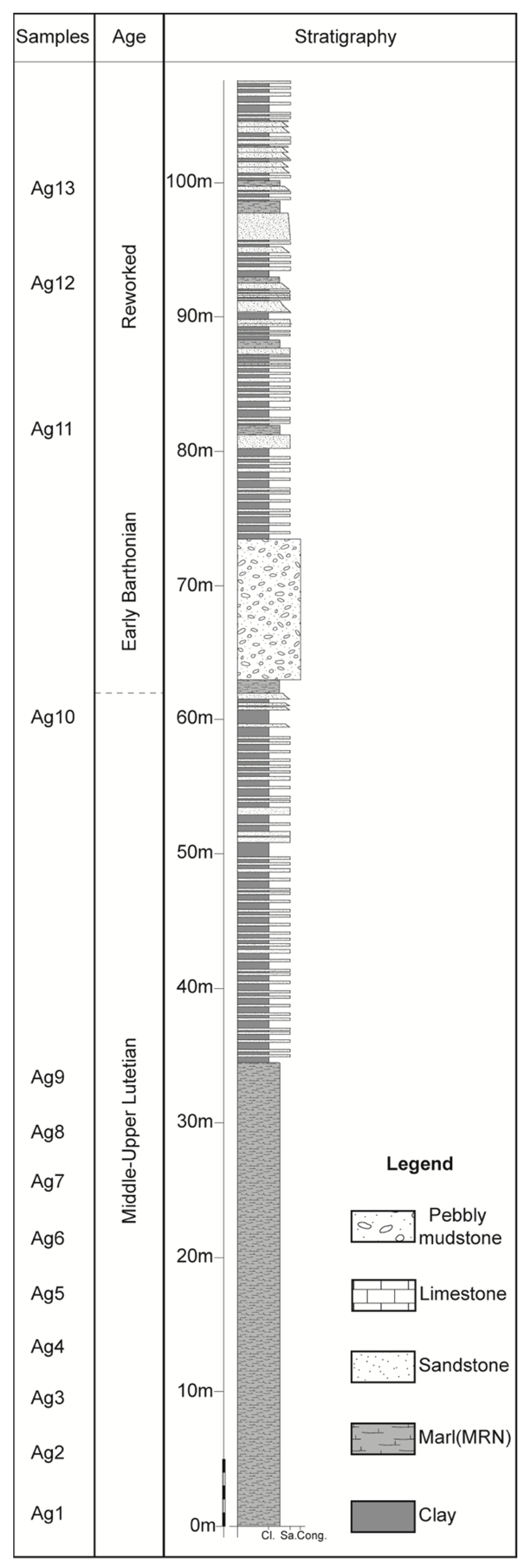
5. Stratigraphy of the Monte Dell’agresto Area
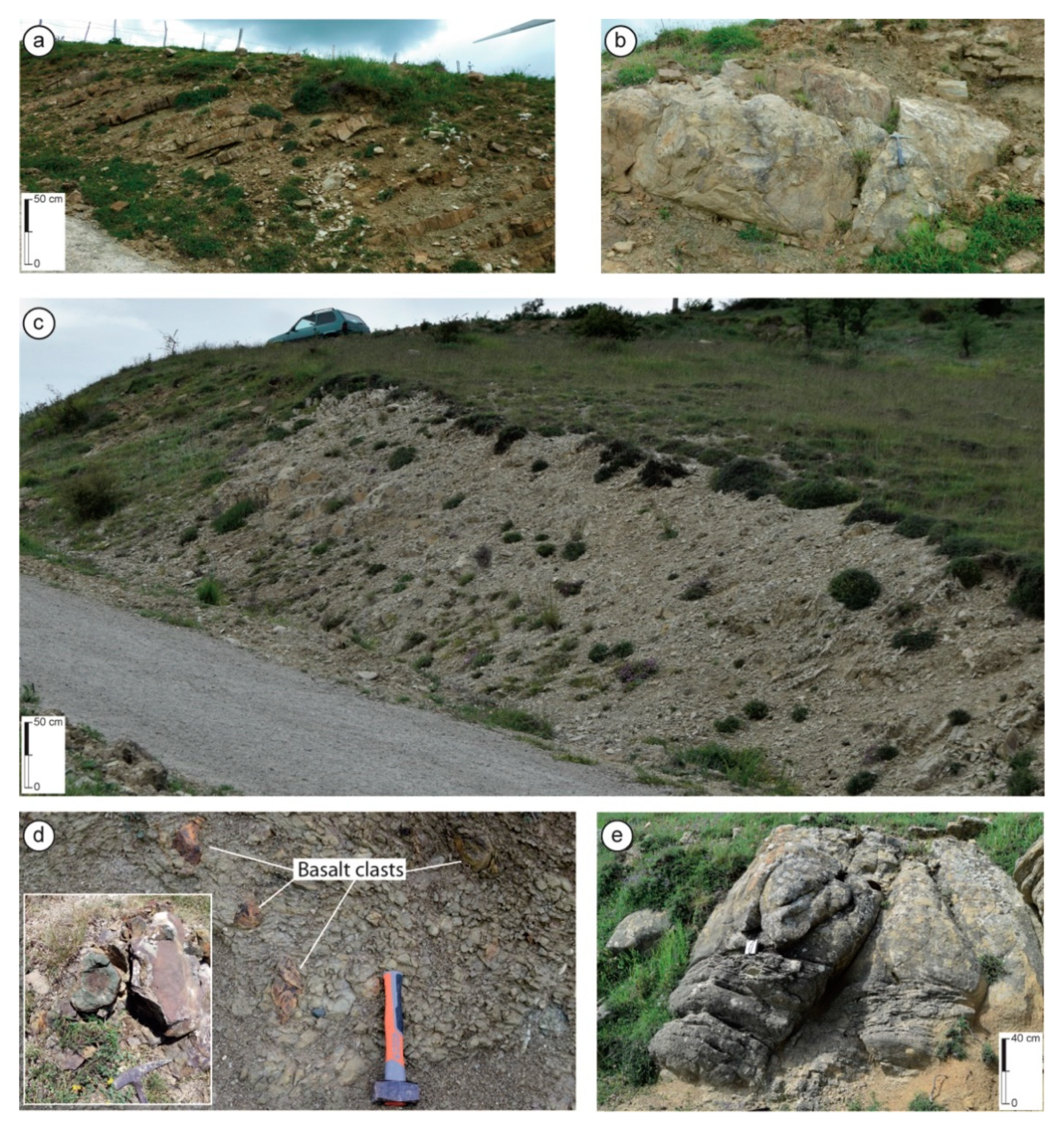
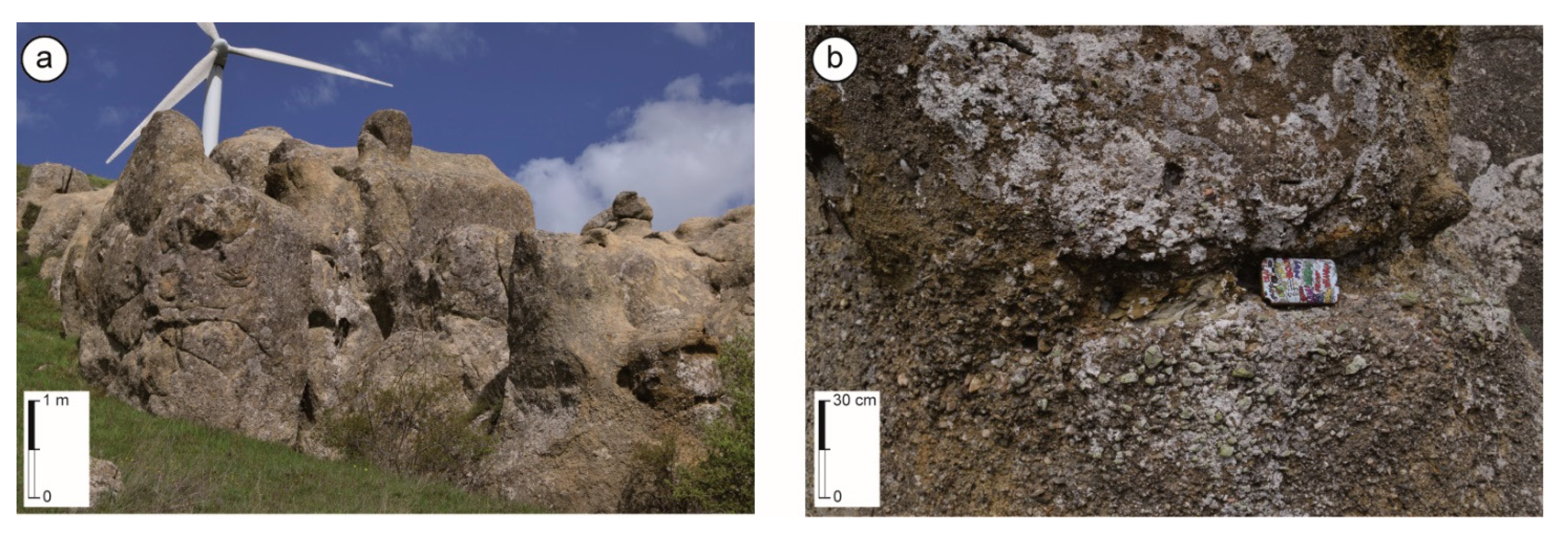
5.1. Albidona Formation, Member B–C
5.2. Albidona Formation, Member D
5.3. Gorgoglione Formation
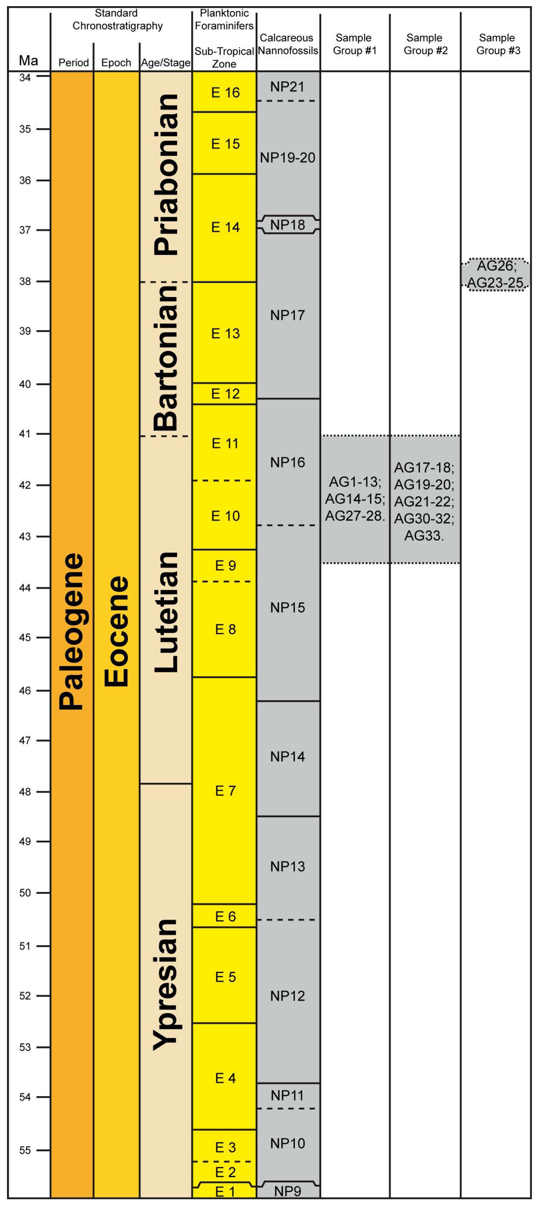
6. Biostratigraphy
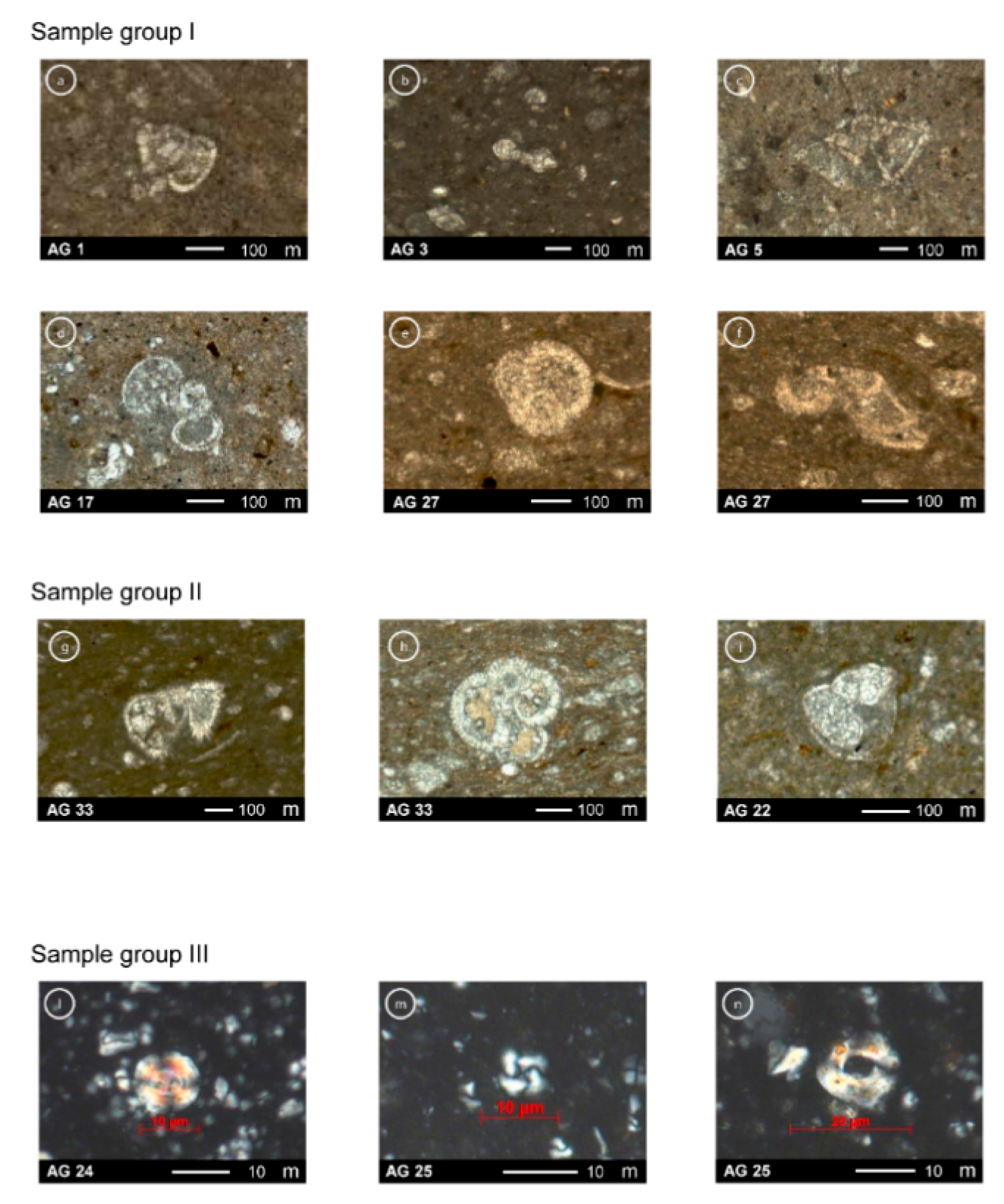
6.1. Group I
6.2. Group II
6.3. Group III
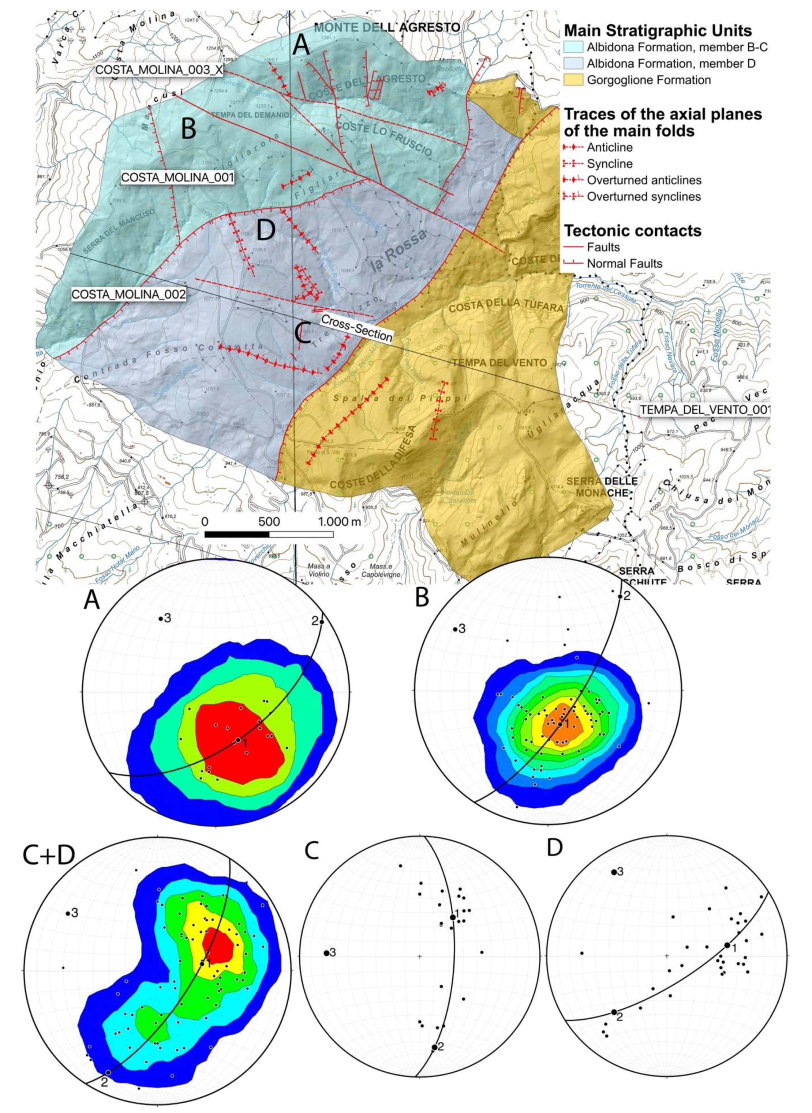
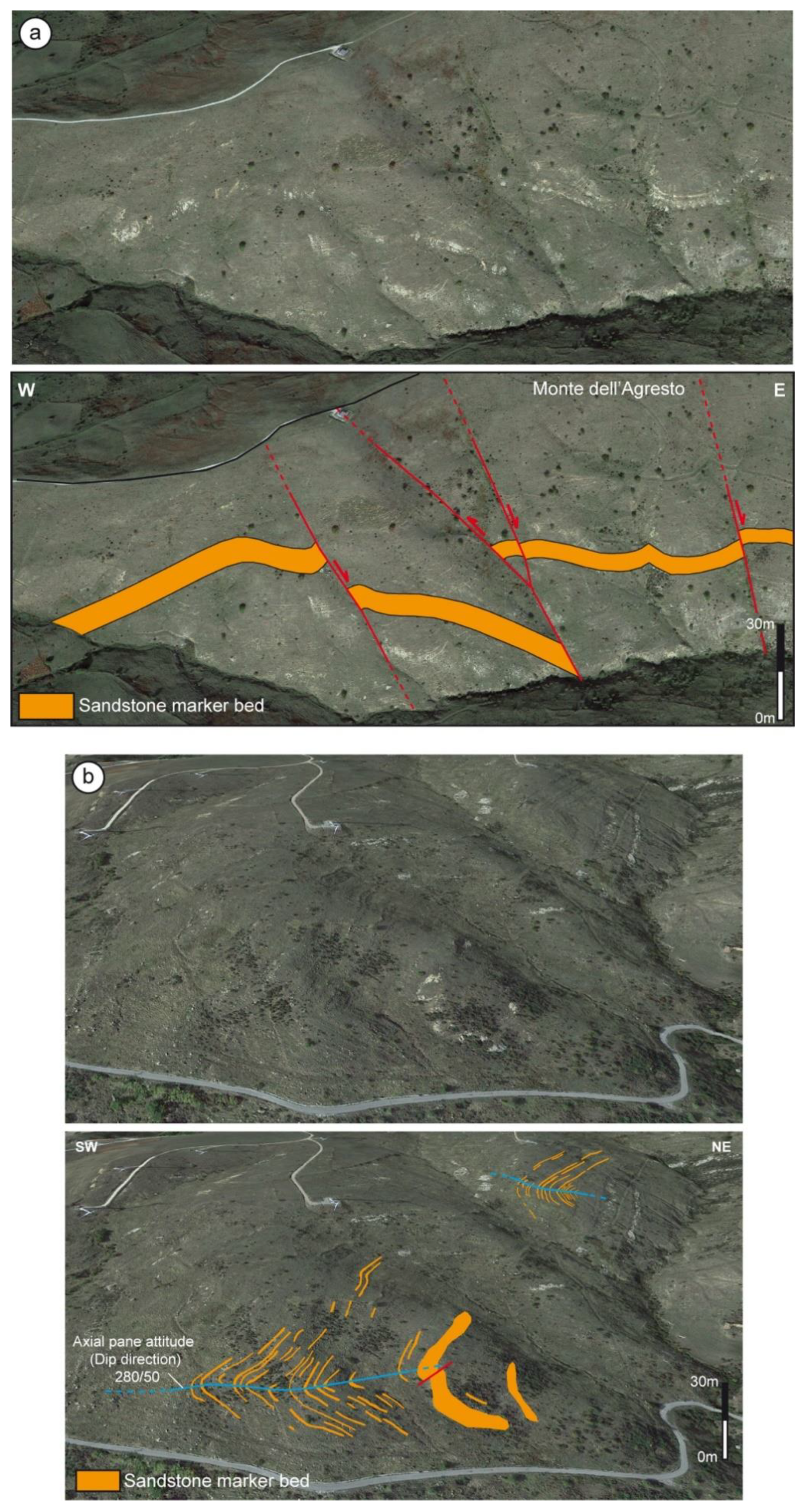
7. Structural Setting of the Monte dell’Agresto Area
7.1. Contractional Structures
7.1.1. Geometry and Orientation of Folds in the Member B–C
7.1.2. Geometry and Orientation of Folds in the Member D
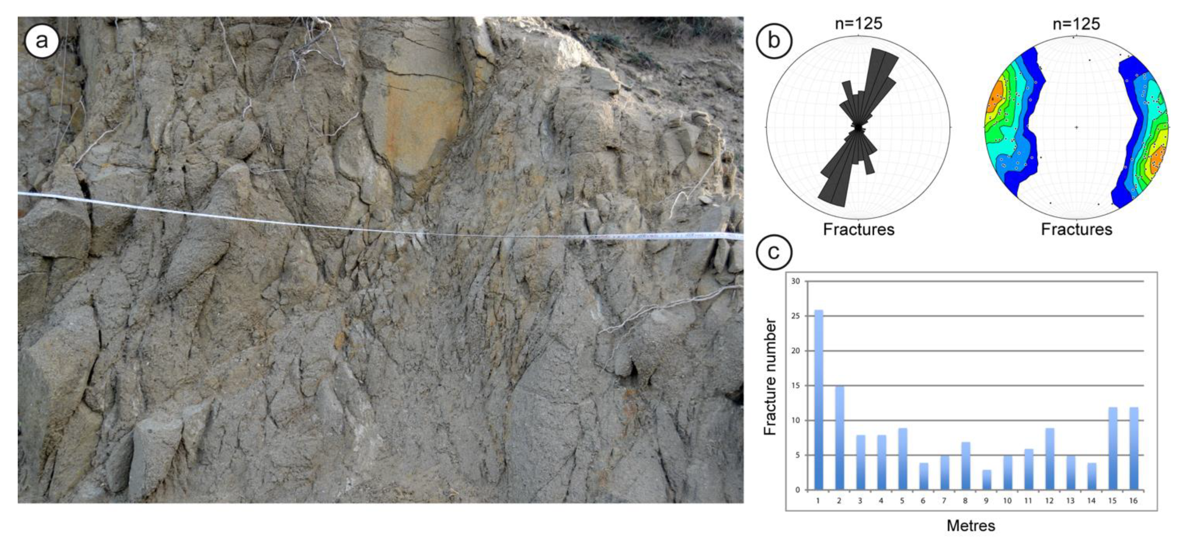
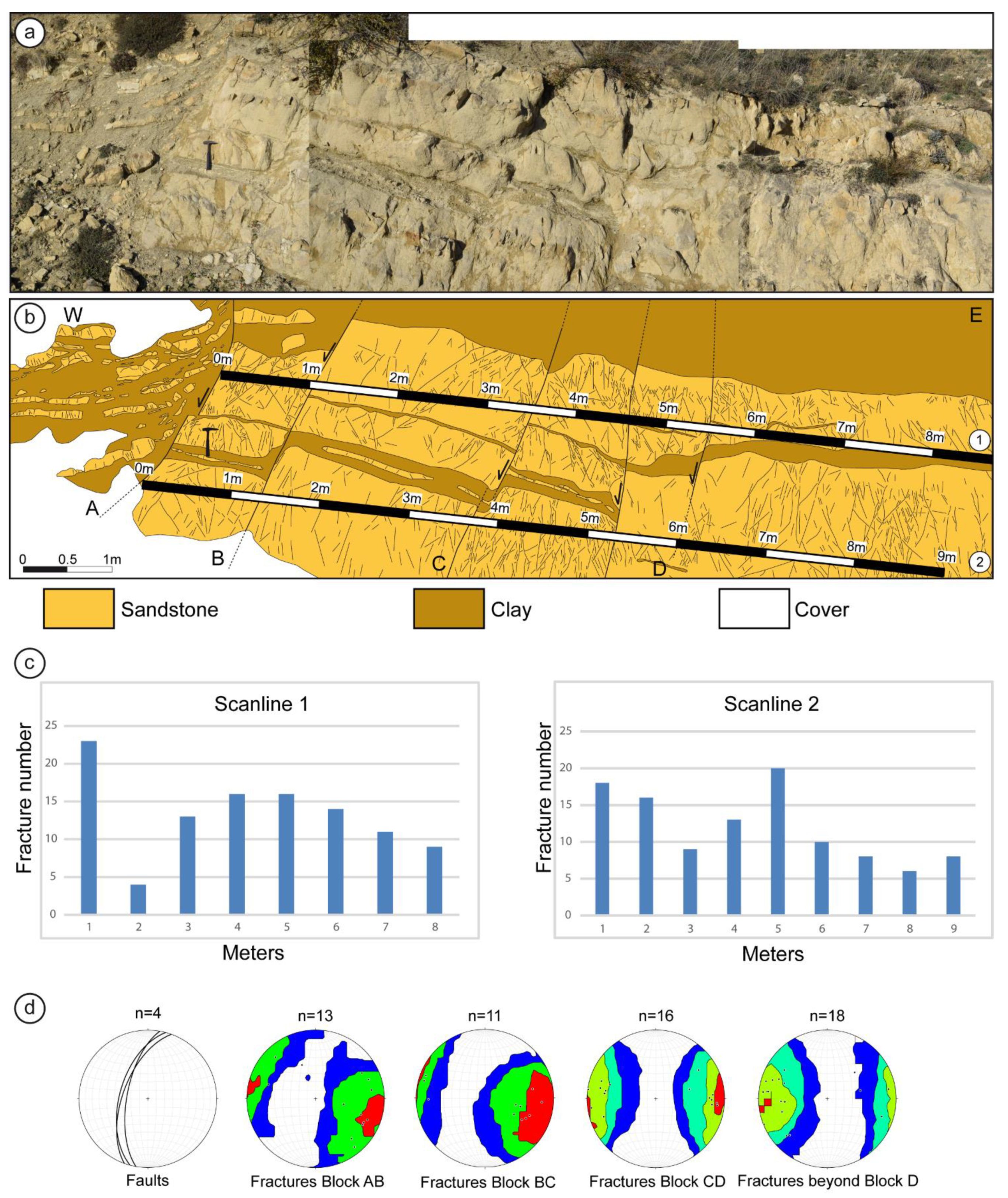
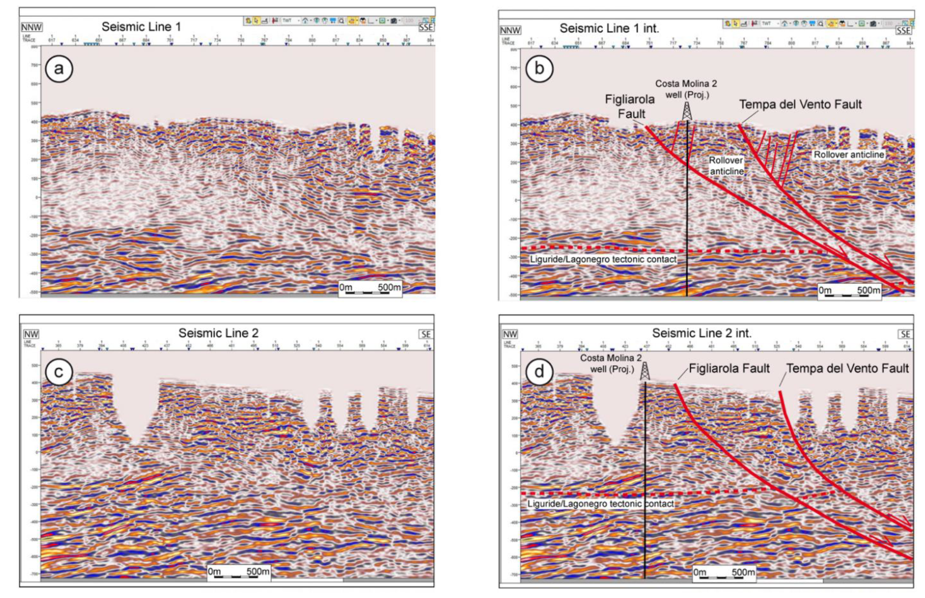
7.2. Extensional Structures
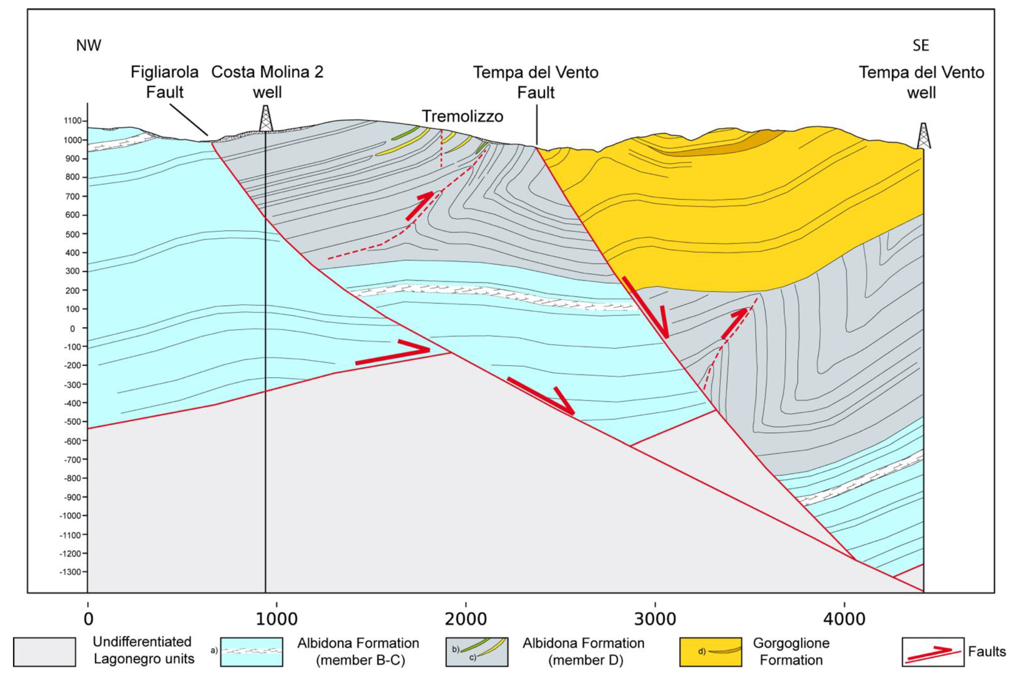
Seismic Profiles
8. Discussion
8.1. Statigraphic Characteristics and Age of the Albidona Formation at the Monte dell’Agresto in Comparison with the Albidona Formation Type-Area
8.2. Geodynamic Significance of the Albidona Formation
8.3. Tectonic Setting of the Study Area
8.4. Significance and Interpretation of the NE-Trending Faults
8.5. Further Implications
9. Conclusions
Author Contributions
Funding
Institutional Review Board Statement
Informed Consent Statement
Acknowledgments
Conflicts of Interest
References
- Prosser, G.; Schiattarella, M.; Tramutoli, M.; Doglioni, C.; Harabaglia, P.; Bigozzi, A. Una sezione rappresentativa dell’Appennino meridionale. In Proceedings of the Conferenza Sulla Ricerca Scientifica in Basilicata, Potenza, Italy, 29 February–1 March 1996. [Google Scholar]
- Patacca, E.; Scandone, P. Geology of Southern Apennines. Bollettino della Società Geologica Italiana. Ital. J. Geosc. 2007, 7, 75–119. [Google Scholar]
- Carbone, S.; Catalano, S.; Lazzari, S.; Lentini, F.; Monaco, C. Presentazione della carta geologica del bacino del Fiume. Agric. Mem. Soc. Geol. Ital. 1991, 47, 129–143. [Google Scholar]
- Bonardi, G.; Amore, F.O.; Ciampo, G.; de Capoa, P.; Miconnet, P.; Perrone, V. Il Complesso Liguride Auctorum: Stato delle conoscenze e problemi aperti sulla sua evoluzione pre-appenninca ed i suoi rapporti con l’arco calabro. Mem. Soc. Geol. Ital. 1988, 41, 17–35. [Google Scholar]
- Sevizio Geologico d’Italia, ISPRA, 2014. Carta Geologica d’Italia Alla Scala 1:50,000, Foglio 505 “Moliterno”. Available online: https://www.isprambiente.gov.it/Media/carg/505_MOLITERNO/Foglio.html (accessed on 30 December 2020).
- Sevizio Geologico d’Italia, ISPRA, 2005. Carta Geologica d’Italia Alla Scala 1:50,000, Foglio 506 “Sant’Arcangelo”. Available online: https://www.isprambiente.gov.it/Media/carg/506_SANT_ARCANGELO/Foglio.html (accessed on 30 December 2020).
- Giano, S.I.; Maschio, L.; Alessio, M.; Ferranti, L.; Improta, S.; Schiattarella, M. Radiocarbon dating of active faulting in the Agri high valley, southern Italy. J. Geodyn. 2000, 29, 371–386. [Google Scholar] [CrossRef]
- Cello, G.; Gambini, R.; Mazzoli, S.; Read, A.; Tondi, E.; Zucconi, V. Fault zone characteristics and scaling properties of the Val d’Agri Fault System (Southern Apennines, Italy). J. Geodyn. 2000, 29, 293–307. [Google Scholar] [CrossRef]
- Hippolyte, J.-C.; Angelier, J.; Roure, F. A major geodynamic change revealed by Quaternary stress patterns in the southern Apennines (Italy). Tectonophysics 1994, 230, 199–210. [Google Scholar] [CrossRef]
- Ferranti, L.; Oldow, J.S. Latest Miocene to Quaternary horizontal and vertical displacement rates during simultaneous contraction and extension in the Southern Apennines orogen, Italy. Terra Nova 2005, 17, 209–214. [Google Scholar] [CrossRef]
- Malinverno, A.; Ryan, W.B.F. Extension in the Tyrrhenian Sea and shortening in the Apennines as result of arc migration driven by sinking of the lithosphere. Tectonics 1986, 5, 227–245. [Google Scholar] [CrossRef]
- Royden, L.; Patacca, E.; Scandone, P. Segmentation and configuration of subducted lithosphere in Italy: An important control on thrust-belt and foredeep-basin evolution. Geology 1987, 15, 714–717. [Google Scholar] [CrossRef]
- Patacca, E.; Sartori, R.; Scandone, P. Tyrrhenian basin and Apenninic arcs: Kinematic relations since Late Tortonian times. Mem. Soc. Geol. Ital. 1990, 45, 425–451. [Google Scholar]
- Doglioni, C. A proposal for the kinematic modelling of W-dipping subductions—Possible applications to the Tyrrhenian-Apennines system. Terra Nova 1991, 3, 423–434. [Google Scholar] [CrossRef]
- Morandi, S.; Ceragoli, E. Integrated interpretation of seismic and resistivity images across the «Val d’Agri» graben (Italy). Ann. Geophys. 2002, 45, 259–271. [Google Scholar]
- Maschio, L.; Ferranti, L.; Burrato, P. Active extension in Val d’Agri area, Southern Apennines, Italy: Implications for the geometry of the seismogenic belt. Geophys. J. Int. 2005, 162, 591–609. [Google Scholar] [CrossRef]
- Burrato, P.; Valensise, G. Rise and Fall of a Hypothesized Seismic Gap: Source Complexity in the Mw 7.0 16 December 1857 Southern Italy Earthquake. Bull. Seism. Soc. Am. 2008, 98, 139–148. [Google Scholar] [CrossRef][Green Version]
- Improta, L.; Ferranti, L.; De Martini, P.M.; Piscitelli, S.; Bruno, P.P.; Burrato, P.; Civico, R.; Giocoli, A.; Iorio, M.; D’Addezio, G.; et al. Detecting young, slow-slipping active faults by geologic and multidisciplinary high-resolution geophysical investigations: A case study from the Apennine seismic belt, Italy. J. Geophys. Res. Space Phys. 2010, 115, 11307. [Google Scholar] [CrossRef]
- Shiner, P.; Beccacini, A.; Mazzoli, S. Thin-skinned versus thick-skinned structural models for Apulian carbonate reservoirs: Constraints from the Val d’Agri Fields, S Apennines, Italy. Mar. Pet. Geol. 2004, 21, 805–827. [Google Scholar] [CrossRef]
- Handy, M.R.; Schmid, S.M.; Bousquet, R.; Kissling, E.; Bernoulli, D. Reconciling plate-tectonic reconstructions of Alpine Tethys with the geological–geophysical record of spreading and subduction in the Alps. Earth-Sci. Rev. 2010, 102, 121–158. [Google Scholar] [CrossRef]
- Knott, S.D. The Liguride Complex of Southern Italy—A Cretaceous to Paleogene accretionary wedge. Tectonophysics 1987, 142, 217–226. [Google Scholar] [CrossRef]
- Vitale, S.; Ciarcia, S.; Fedele, L.; Tramparulo, F.D. The Ligurian oceanic successions in southern Italy: The key to decrypting the first orogenic stages of the southern Apennines-Calabria chain system. Tectonophysics 2019, 750, 243–261. [Google Scholar] [CrossRef]
- Scandone, P. Studi di geologia lucana: Carta dei terreni della serie calcareo-silico-marnosa e note illustrative. Boll. Soc. Natur. Napoli 1972, 273, 225–299. [Google Scholar]
- Bucci, F.; Novellino, R.; Tavarnelli, E.; Prosser, G.; Guzzetti, G.; Cardinali, M.; Gueguen, E.; Guglielmi, P.; Adurno, I. Frontal collapse during thrust propagation in mountain belts: A case study in the Lucanian Apennines, Southern Italy. J. Geol. Soc. 2014, 171, 571–581. [Google Scholar] [CrossRef]
- Patacca, E.; Scandone, P. Late thrust propagation and sedimentary response in the thrust-beltforedeep system of the Southern Apennines (Pliocene-Pleistocene). In Anatomy of an Orogen: The Apennines and Adjacent Mediterranean Basins; Vai, G.B., Martini, I.P., Eds.; Kluwer Academic Publishers: London, UK, 2001. [Google Scholar]
- Noguera, A.; Rea, G. Deep structure of the Campanian–Lucanian Arc (Southern Apennine, Italy). Tectonophysics 2000, 324, 239–265. [Google Scholar] [CrossRef]
- Boiano, U. Anatomy of a siliciclastic turbidite basin: The Gorgoglione Flysch, Upper Miocene, southern Italy: Physical stratigraphy, sedimentology and sequence-stratigraphic framework. Sediment. Geol. 1997, 107, 231–262. [Google Scholar] [CrossRef]
- Cavalcante, F.; Fiore, S.; Lettino, A.; Piccarreta, G.; Tateo, F. Illite-smectite mixed layers in Sicilide shales and piggy-back deposits of the Gorgoglione Formation (Southern Apennines): Geological inference. Boll. Soc. Geol. Ital. 2007, 126, 241–254. [Google Scholar]
- Cavalcante, F.; Prosser, G.; Agosta, F.; Belviso, C.; Corrado, G. Post-depositional history of the Miocene Gorgoglione Formation (southern Apennines, Italy): Inferences from mineralogical and structural analyses. Bull. Soc. Géol. Fr. 2015, 186, 243–256. [Google Scholar] [CrossRef]
- Buttinelli, M.; Improta, L.; Bagh, S.; Chiarabba, C. Inversion of inherited thrusts by wastewater injection induced seismicity at the Val d’Agri oilfield (Italy). Sci. Rep. 2016, 6, 37165. [Google Scholar] [CrossRef]
- Selli, R. Il Paleogene nel quadro della geologia dell’Italia centro-meridionale. Mem. Soc. Geol. Ital. 1962, 3, 737–789. [Google Scholar]
- Zuppetta, A.; Russo, M.; Turco, E.; Gallo, L. Età e significato della Formazione di Albidona in Appennino Meridionale. Boll. Soc. Geol. Ital. 1984, 103, 159–170. [Google Scholar]
- Baruffini, L.; Lottaroli, F.; Torricelli, S.; Lazzari, D. Stratigraphic revision of the Eocene Albidona Formation in the type locality (Calabria, southern Italy). Riv. Ital. Paleontol. Stratigr. 2000, 106, 73–98. [Google Scholar]
- Critelli, S.; Muto, F.; Tripodi, V.; Perri, F. Link between thrust tectonics and sedimentation processes of stratigraphic sequences from the southern Apennines foreland basin system, Italy. Rend. Online Soc. Geol. Ital. 2013, 25, 21–42. [Google Scholar]
- Colella, A.; Zuffa, G.G. Megastrati carbonatici e silicoclastici della Formazione di Albidona (Miocene, Appennino meridionale): Implicazioni paleogeografiche. Mem. Soc. Geol. Ital. 1988, 41, 791–807. [Google Scholar]
- Dietrich, D.; Scandone, P. The position of basic and ultrabasic rocks in the tectonic units of the southern Apennines. Atti dell’Accademia Pontiana 1972, 21, 1–15. [Google Scholar]
- Kastens, K.A.; Cita, M.B. Tsunami-induced sediment transport in the abyssal Mediterranean Sea. GSA Bull. 1981, 92, 845–857. [Google Scholar] [CrossRef]
- Cita, M.B.; Camerlenghi, A.; Rimoldi, B. Deep-sea tsunami deposits in the eastern Mediterranean: New evidence and depositional models. Sediment. Geol. 1996, 104, 155–173. [Google Scholar] [CrossRef]
- Pavan, G.; Pirini, C. Microfossili cretacici ed eocenici nella zona di Monte Falapato (Lucania). Mem. Soc. Geol. Ital. 1963, 4, 1105–1134. [Google Scholar]
- Mostardini, F.; Pieri, M.; Pirini, C. Stratigrafia del foglio 212, Montalbano Jonico. Boll. Serv. Geol. Ital. 1966, 87, 541–547. [Google Scholar]
- Ogniben, L. Schema introduttivo alla geologia del confine calabro-lucano. Mem. Soc. Geol. Ital. 1969, 8, 453–763. [Google Scholar]
- Vezzani, L. Nota preliminare sulla stratigrafia della Formazione di Albidona. Boll. Soc. Geol. Ital. 1966, 85, 767–776. [Google Scholar]
- Vezzani, L. Distribuzione, facies e stratigrafia della Formazione del Saraceno (Albiano—Daniano) nell’area compresa tra il Mare Jonio e il Torrente Frido. Geol. Rom. 1968, 7, 229–276. [Google Scholar]
- Vezzani, L. Il Flysch di Albidona nell’area del confine tra Calabria e Lucania. Geol. Rom. 1970, 9, 101–126. [Google Scholar]
- Bonardi, G.; Ciampo, G.; Perrone, V. La Formazione di Albidona nell’Appennino calabro-lucano: Ulteriori dati stratigrafici e relazioni con le unità esterne appenniniche. Boll. Soc. Geol. Ital. 1985, 104, 539–549. [Google Scholar]
- Sevizio Geologico d’Italia, ISPRA, 2009. Carta Geologica d’Italia alla scala 1:50,000, Foglio 535 “Trebisacce”. Available online: https://www.isprambiente.gov.it/Media/carg/535_TREBISACCE/Foglio.html (accessed on 30 December 2020).
- Lentini, F.; Carbone, S.; Catalano, S.; Monaco, C. Confronti sedimentologico petrografici e posizione strutturale del Flysch di Albidona e di Gorgoglione nella media Val d’Agri (Appennino lucano). Mem. Soc. Geol. Ital. 1987, 38, 259–263. [Google Scholar]
- Vezzani, L.; Festa, A.; Ghisetti, F.C. Geology and Tectonic Evolution of the Central-Southern Apennines, Italy; Geological Society of America: Boulder, CO, USA, 2010. [Google Scholar]
- Patacca, E.; Scandone, P.; Bellatalla, M.; Perilli, N.; Santini, U. Numidian sand event in the Southern Apennines. Mem. Soc. Geol. Padova 1992, 43, 297–337. [Google Scholar]
- Palladino, G.; Parente, M.; Prosser, G.; Di Staso, A. Tectonic control on the deposition of the Lower Miocene sediments of the Monti della Maddalena ridge (Southern Apennines): Synsedimentary extensional deformation in a foreland setting. Boll. Soc. Geol. Ital. 2008, 127, 317–335. [Google Scholar]
- Okada, H.; Bukry, D. Supplementary modification and introduction of code numbers to the low-latitude coccolith biostratigraphic zonation (Bukry, 1973; 1975). Mar. Micropaleontol. 1980, 5, 321–325. [Google Scholar] [CrossRef]
- Martini, E. Standard Tertiary and Quaternary calcareous nannoplankton zonation. In Proceedings of the Second Planktonic Conference, Roma, 1970; Tecnoscienza: Roma, Italy, 1971; pp. 739–765. [Google Scholar]
- Perch-Nielsen, K. Cenozoic calcareous nannofossils. In Plankton Stratigraphy; Bolli, H.M., Saunders, J.B., PerchNielsen, K., Eds.; Cambridge University Press: Cambridge, UK, 1985; pp. 427–554. [Google Scholar]
- Bown, P.R. Calcareous Nannofossil Biostratigraphy; Kluwer Academic Publishers: Norwell, MA, USA, 1998; pp. 1–315. [Google Scholar]
- Gradstein, F.M.; Ogg, J.G.; Schmitz, M.D.; Ogg, G.M. The Geological Time Scale 2012; Elsevier: Amsterdam, The Netherlands, 2012. [Google Scholar]
- Priest, S.D. Discontinuity Analysis for Rock Engineering; Springer Science and Business Media LLC.: Secaucus, NJ, USA, 1993. [Google Scholar]
- Ortega, O.J.; Marrett, R.A.; Laubach, S.E. A scale-independent approach to fracture intensity and average spacing measurement. AAPG Bull. 2006, 90, 193–208. [Google Scholar] [CrossRef]
- Bouma, A.H. Sedimentology of Some Flysch Deposits; Elsevier: Amsterdam, The Netherlands, 1962. [Google Scholar]
- Sartoni, S.; Crescenti, U. Ricerche Biostratigrafiche nel Mesozoico dell’Appennino Meridionale; Museo Geologico Giovanni Capellini: Bologna, Italy, 1962; Volume 29, pp. 153–302. [Google Scholar]
- Scandone, P.; Sgrosso, I. Flysch con Inocerami nella Valle del Cavolo presso Tramutola (Lucania). Boll. Soc. Natur. Napoli 1964, 73, 166–175. [Google Scholar]
- Giannandrea, P.; LoIacono, F.; Maiorano, P.; Lirer, F.; Puglisi, D. Geological map of the eastern sector of the Gorgoglione Basin (southern Italy). Ital. J. Geosci. 2016, 135, 120–141. [Google Scholar] [CrossRef]
- Ramsay, J.G. Folding and Fracturing of Rocks; McGraw-Hill: New York, NY, USA, 1967. [Google Scholar]
- Kim, Y.-S.; Peacock, D.C.; Sanderson, D.J. Fault damage zones. J. Struct. Geol. 2004, 26, 503–517. [Google Scholar] [CrossRef]
- Choi, J.-H.; Edwards, P.; Ko, K.; Kim, Y.-S. Definition and classification of fault damage zones: A review and a new methodological approach. Earth-Sci. Rev. 2016, 152, 70–87. [Google Scholar] [CrossRef]
- McClay, K. Extensional fault systems in sedimentary basins: A review of analogue model studies. Mar. Pet. Geol. 1990, 7, 206–233. [Google Scholar] [CrossRef]
- Caggianelli, A.; Prosser, G. An exposed cross-section of Late Hercynian upper and intermediate continental crust exposed in the Sila Nappe (Calabria, Southern Italy). Period. Mineral. 2001, 70, 275–301. [Google Scholar]
- Langone, A.; Godard, G.; Prosser, G.; Caggianelli, A.; Rottura, A.; Tiepolo, M. P–T–t path of the Hercynian low-pressure rocks from the Mandatoriccio complex (Sila Massif, Calabria, Italy): New insights for crustal evolution. J. Metamorph. Geol. 2010, 28, 137–162. [Google Scholar] [CrossRef]
- Festa, V.; Langone, A.; Caggianelli, A.; Rottura, A. Dike magmatism in the Sila Grande (Calabria, southern Italy): Evidence of Pennsylvanian–Early Permian exhumation. Geosophy 2010, 6, 549–566. [Google Scholar] [CrossRef]
- Cavalcante, F.; Belviso, C.; Finizio, F.; Lettino, A.; Fiore, S. Carta Geologica delle Unità Liguridi Dell’area del Pollino (Basilicata): Nuovi dati Geologici, Mineralogici e Petrografici; Digilabs: Bari, Italy, 2009. [Google Scholar]
- Liberi, F.; Morten, L.; Piluso, E. Geodynamic significance of ophiolites within the Calabrian Arc. Isl. Arc 2006, 15, 26–43. [Google Scholar] [CrossRef]
- Shimabukuro, D.H.; Wakabayashi, J.; Alvarez, W.; Chang, S.-C. Cold and old: The rock record of subduction initiation beneath a continental margin, Calabria, southern Italy. Lithosphere 2012, 4, 524–532. [Google Scholar] [CrossRef]
- Tursi, F.; Bianco, C.; Brogi, A.; Caggianelli, A.; Prosser, G.; Ruggieri, G.; Braschi, E. Cold subduction zone in northern Calabria (Italy) revealed by lawsonite–clinopyroxene blueschists. J. Metamorph. Geol. 2020, 38, 451–469. [Google Scholar] [CrossRef]
- Mazzoli, S.; Barkham, S.; Cello, G.; Gambini, R.; Mattioni, L.; Shiner, P.; Tondi, E. Reconstruction of continental margin architecture deformed by the contraction of the Lagonegro Basin, southern Apennines, Italy. J. Geol. Soc. 2001, 158, 309–319. [Google Scholar] [CrossRef]
- Vitale, S.; Ciarcia, S. Tectono-stratigraphic and kinematic evolution of the southern Apennines/Calabria–Peloritani Terrane system (Italy). Tectonophysics 2013, 583, 164–182. [Google Scholar] [CrossRef]
- Bonini, M.; Sani, F. Pliocene-Quaternary transpressional evolution of the Anzi-Calvello and Northern S. Arcangelo basins (Basilicata, Southern Apennines, Italy) as a consequence of deep-seated fault reactivation. Mar. Pet. Geol. 2000, 17, 909–927. [Google Scholar] [CrossRef]
- Bucci, F.; Novellino, R.; Guglielmi, P.; Prosser, G.; Tavarnelli, E. Geological map of the northeastern sector of the high Agri Valley, Southern Apennines (Basilicata, Italy). J. Maps 2012, 8, 282–292. [Google Scholar] [CrossRef]
- Ferranti, L.; Oldow, J.S.; Sacchi, M. Pre-Quaternary orogen-parallel extension in the Southern Apennine belt, Italy. Tectonophysics 1996, 260, 325–347. [Google Scholar] [CrossRef]
- Novellino, R.; Prosser, G.; Spiess, R.; Viti, C.; Agosta, F.; Tavarnelli, E.; Bucci, F. Dynamic weakening along incipient low-angle normal faults in pelagic limestones (Southern Apennines, Italy). J. Geol. Soc. 2015, 172, 283–286. [Google Scholar] [CrossRef]
- Giano, S.I.; Pescatore, E.; Agosta, F.; Prosser, G. Geomorphic evidence of Quaternary tectonics within an underlap fault zone of southern Apennines, Italy. Geomorphology 2018, 303, 172–190. [Google Scholar] [CrossRef]


| Samples | Markers (Calcareous Nannoplankton) | Markers (Plantktonic Foraminifera) |
|---|---|---|
| AG 28 | Sphenolithus radians, Girgisia gammation, Toweius pertusus, Discoaster barbadiensis Sample biostratigraphic range: NP11–14 | Acarinina cf. topilensis, Chiloguembelina sp., Turborotalia sp. Sample biostratigraphic range: E10–E11 |
| AG 27 | S. radians, G. gammation, T. pertusus, D. barbadiensis Sample biostratigraphic range: NP11–14 | Acarinina cf. boudreauxi, Morozovelloides sp.? Chi-loguembelina sp., Subbotina spp., Globigerinatheka sp., Morozovella cf. caucasica, Globotruncanidae (rew.) Sample biostratigraphic range: E10–E11 |
| AG 15 | S. radians, G. gammation, Toweius callosus, T. pertusus Sample biostratigraphic range: NP11–14 | Barren |
| AG 14 | S. radians, G. gammation, T. callosus, T. pertusus Sample biostratigraphic range: NP11–14 | Barren |
| AG 13 | S. radians, G. gammation, Sphenolithus orphanknollensis, Nannotetrina sp., D. barbadiensis Sample biostratigraphic range: NP12–15 | Barren |
| AG 12 | S. radians, G. gammation, S. orphanknollensis, Nannotetrina sp., D. barbadiensis Sample biostratigraphic range: NP12–15 | Very rare indeterminated planktonic foraminifera |
| AG 11 | S. radians, G. gammation, S. orphanknollensis, Nannotetrina sp., D. barbadiensis Sample Biostratigraphic range: NP12–15 | Barren |
| AG 10 | S. radians, G. gammation, S. orphanknollensis, Nannotetrina sp., D. barbadiensis Sample biostratigraphic range: NP12–15 | Rare indeterminated planktonic foraminifera |
| AG 9 | Sphenolithus predistentus, Helicosphaera lophota, G. gammation Sample Biostratigraphic range: NP16 | Barren |
| AG 8 | generic Eocene association | Acarinina spp. and small indeterminated planktonic foraminifera |
| AG 7 | Sphenolithus spiniger, Sphenolithus furcatolithoides Sample biostratigraphic range: NP15/16 | Morozovella aequa (rew.), Acarinina soldadoensis (rew.) Sample biostratigraphic range: not younger than E7 |
| AG 6 | S. radians, G. gammation, S. furcatolithoides, D. barbadiensis Sample biostratigraphic range: NP15 | Acarinina bullbrooki, Acarinina spp. Sample biostratigraphic range: E7–E11 |
| AG 5 | S. radians, G. gammation, T. pertusus, T. callosus Sample biostratigraphic range: NP11–14 | Acarenina cf. soldadoensis (rew), Morozovella aragonensis Sample biostratigraphic range: E7–E11 |
| AG 4 | S. radians, G. gammation, T. pertusus, T. callosus Sample biostratigraphic range: NP11–14 | Acarinina sp., Morozovella sp. Sample biostratigraphic range: not younger than E9 |
| AG 3 | S. radians, G. gammation, T. pertusus, T. callosus Sample biostratigraphic range: NP11–14 | Acarinina bullbrooki, Subbotina spp., Globanomalina cf. compressa (rew.) Sample biostratigraphic range: E7–E11 |
| AG 2 | S. radians, G. gammation, T. pertusus, T. callosus Sample biostratigraphic range: NP11–14 | Acarinina sp., Morozovella sp. Sample biostratigraphic range: not younger than E9 |
| AG 1 | S. radians, G. gammation, T. pertusus, T. callosus Sample biostratigraphic range: NP11–14 | Acarinina bullbrooki, Subbotina spp., Morozovella spp. Sample biostratigraphic range: E7–E11 |
| Samples | Markers (Calcareous Nannoplankton) | Markers (Plantktonic Foraminifera) |
|---|---|---|
| AG 18 | S. spiniger Sample biostratigraphic range: NP16 | Acarinina cf. boudreauxi Sample biostratigraphic range: E7–E9 |
| AG 17 | S. spiniger Sample biostratigraphic range: NP16 | Acarinina spp., A. cf. pentacamerata (rew.), A. soldadoensis (rew.), Chiloguembelina cf. cubensis Sample biostratigraphic range: E10 or younger |
| AG 22 | Discoaster salisburgensis, S. radians, G. gammation Sample biostratigraphic range: NP11–12 | Acarinina spp., A. cf. bullbrooki, A. soldadoensis (rew), Globanomalina sp. (rew.) Sample biostratigraphic range: E7–E11 |
| AG 21 | D. salisburgensis, S. radians, G. gammation Sample Biostratigraphic range: NP11–12 | Acarinina spp., A. cf. boudreauxi, Acarinina soldadoensis (rew), Igorina sp. (rew.), Morozovella aequa (rew.) Sample biostratigraphic range: E7–E11 |
| AG 20 | S. radians, G. gammation, T. callosus, T. pertusus Sample biostratigraphic range: NP11–14 | Acarinina spp., A. cf. boudreauxi, Acarinina soldadoensis (rew), Chiloguembelina crinita, Morozovelloides sp.? Subbotina spp. Sample biostratigraphic range: E7–E13 |
| AG 19 | S. radians, G. gammation, T. callosus, T. pertusus Sample biostratigraphic range: NP11–14 | Acarinina spp., A. cf. boudreauxi, A. pentacamerata (rew), Chiloguembelina spp., Igorina pusilla (rew.) Sample biostratigraphic range: E7–E9 |
| AG 30 | S. radians, G. gammation, Campylosphaera dela, Discoaster saipanensis D. barbadiensis Sample biostratigraphic range: NP14 | Very rare small planktonic foraminifera fragments |
| AG 31 | S. radians, G. gammation, C. dela, D. saipanensis, D. barbadiensis Sample biostratigraphic range: NP14 | No sample |
| AG 32 | S. radians, G. gammation, T. callosus, T. pertusus Sample biostratigraphic range: NP11–14 | No sample |
| AG 33 | S. radians, G. gammation, T. callosus, T. pertusus Sample biostratigraphic range: NP11–14 | Acarinina bullbrooki, A. cf. aspensis, Globigerinatheka sp., Chiloguembelina sp., Morozovella spp., M. aequa (rew.), Globanomalina compressa (rew.), Igorina albeari (rew.) Sample biostratigraphic range: E7–E11 |
| Samples | Markers (Calcareous Nannoplankton) | Markers (Plantktonic Foraminifera) |
|---|---|---|
| AG 26 | Cribrocentrum reticulatum, Dictyococcites bisectus, Reticulofenestra umbilicus, Sphenolithus obtusus, Cribrocentrum erbae Sample biostratigraphic range: NP17 | Barren |
| AG 25 | Cr. reticulatum, D. bisectus, R. umbilicus, S. obtusus, Cr. erbae, Blackites sp. Sample biostratigraphic range: NP17 | Barren |
| AG 24 | Cr. reticulatum, D. bisectus, R. umbilicus, S. obtusus, Cr. erbae, Blackites sp. Sample biostratigraphic range: NP17 | Barren |
| AG 23 | Cr. reticulatum, D. bisectus, R. umbilicus, S. obtusus, Cr. erbae, Blackites sp. Sample biostratigraphic range: NP17 | Barren |
Publisher’s Note: MDPI stays neutral with regard to jurisdictional claims in published maps and institutional affiliations. |
© 2021 by the authors. Licensee MDPI, Basel, Switzerland. This article is an open access article distributed under the terms and conditions of the Creative Commons Attribution (CC BY) license (http://creativecommons.org/licenses/by/4.0/).
Share and Cite
Prosser, G.; Palladino, G.; Avagliano, D.; Coraggio, F.; Bolla, E.M.; Riva, M.; Catellani, D.E. Stratigraphic and Tectonic Setting of the Liguride Units Cropping Out along the Southeastern Side of the Agri Valley (Southern Apennines, Italy). Geosciences 2021, 11, 125. https://doi.org/10.3390/geosciences11030125
Prosser G, Palladino G, Avagliano D, Coraggio F, Bolla EM, Riva M, Catellani DE. Stratigraphic and Tectonic Setting of the Liguride Units Cropping Out along the Southeastern Side of the Agri Valley (Southern Apennines, Italy). Geosciences. 2021; 11(3):125. https://doi.org/10.3390/geosciences11030125
Chicago/Turabian StyleProsser, Giacomo, Giuseppe Palladino, Dario Avagliano, Francesco Coraggio, Eleonora Maria Bolla, Marcello Riva, and Daniele Enrico Catellani. 2021. "Stratigraphic and Tectonic Setting of the Liguride Units Cropping Out along the Southeastern Side of the Agri Valley (Southern Apennines, Italy)" Geosciences 11, no. 3: 125. https://doi.org/10.3390/geosciences11030125
APA StyleProsser, G., Palladino, G., Avagliano, D., Coraggio, F., Bolla, E. M., Riva, M., & Catellani, D. E. (2021). Stratigraphic and Tectonic Setting of the Liguride Units Cropping Out along the Southeastern Side of the Agri Valley (Southern Apennines, Italy). Geosciences, 11(3), 125. https://doi.org/10.3390/geosciences11030125