
The Geo-Hydro-Mechanical Properties of a Turbiditic Formation as Internal Factors of Slope Failure Processes

 , and
, and 
Abstract
:1. Introduction
2. Geo-Hydro-Mechanical Settings of the Faeto Flysch in the Daunia Apennines
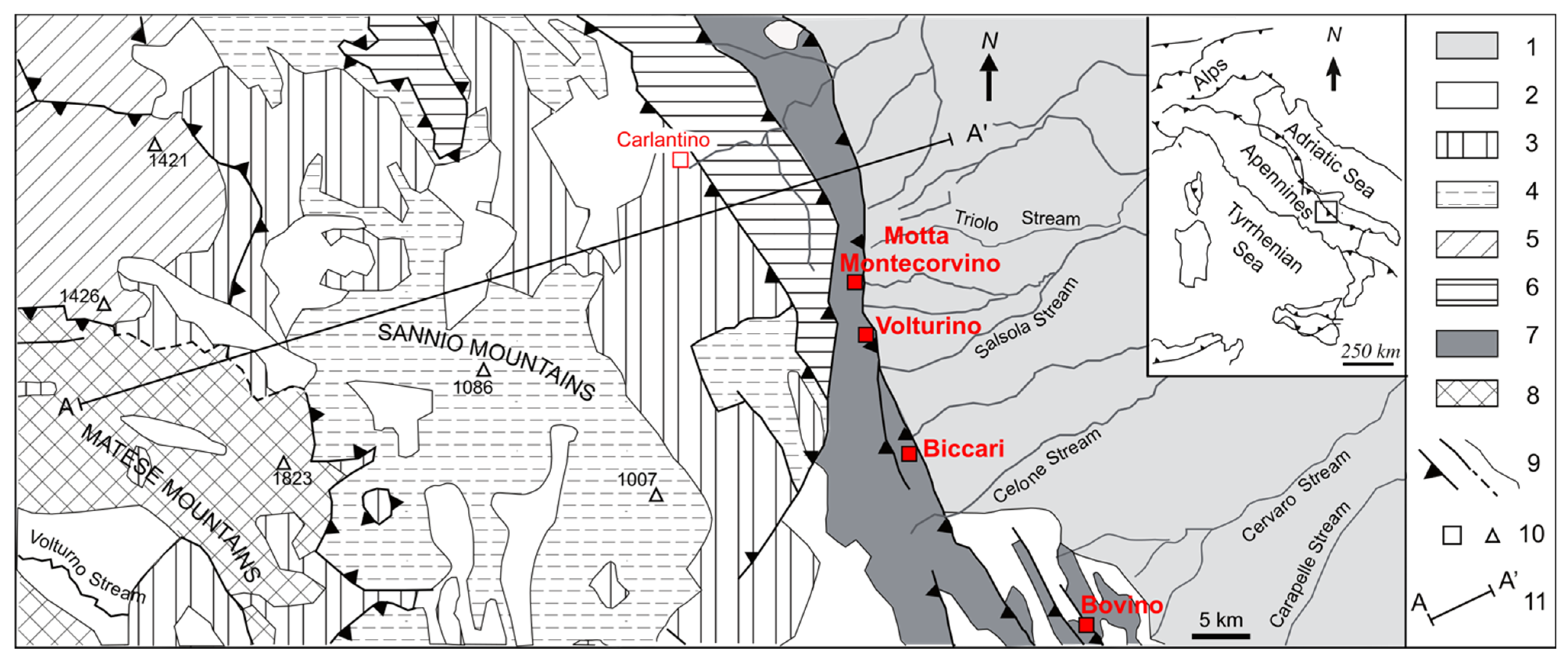
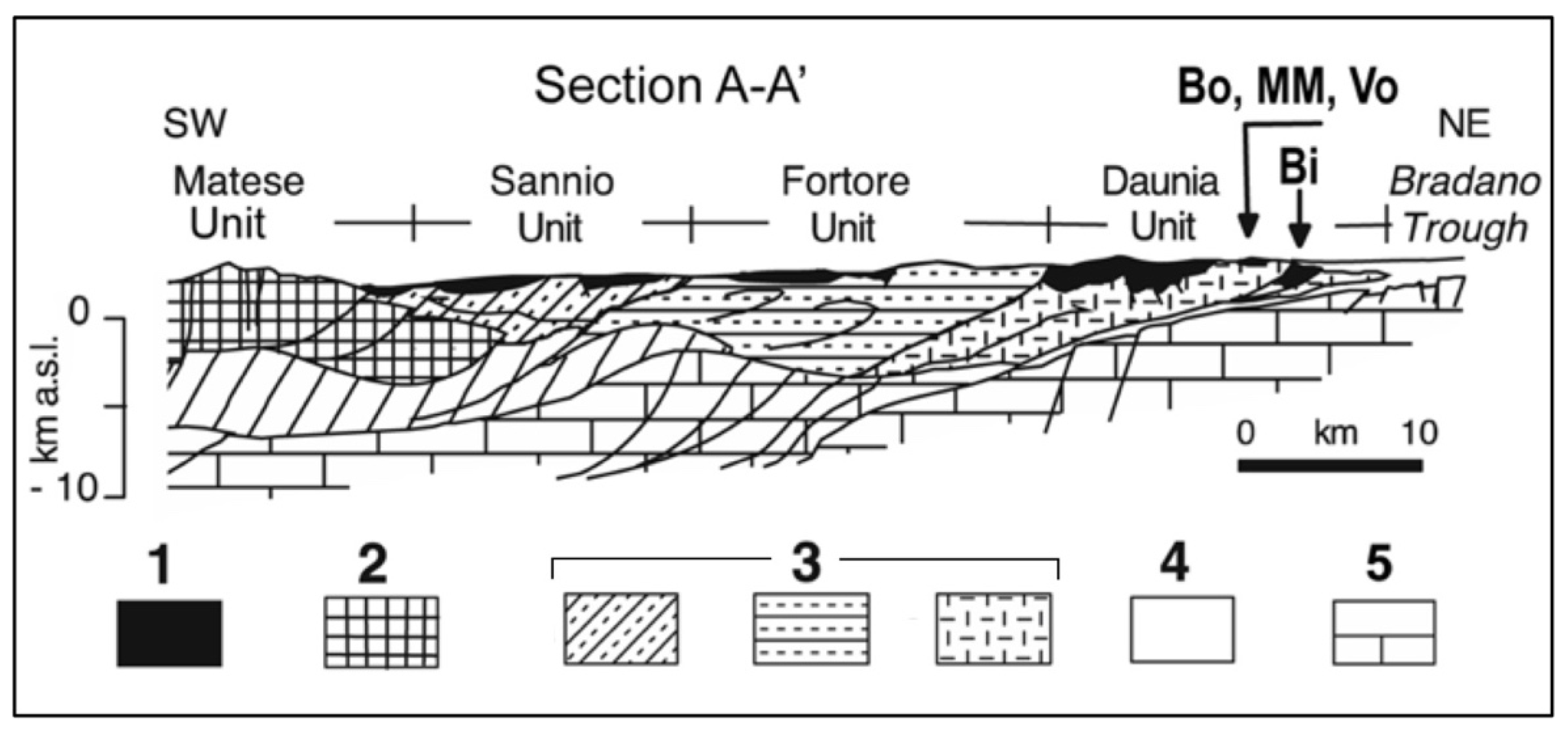
2.1. Paleogeography and Current Geo-Structural Setting of Faeto Flysch
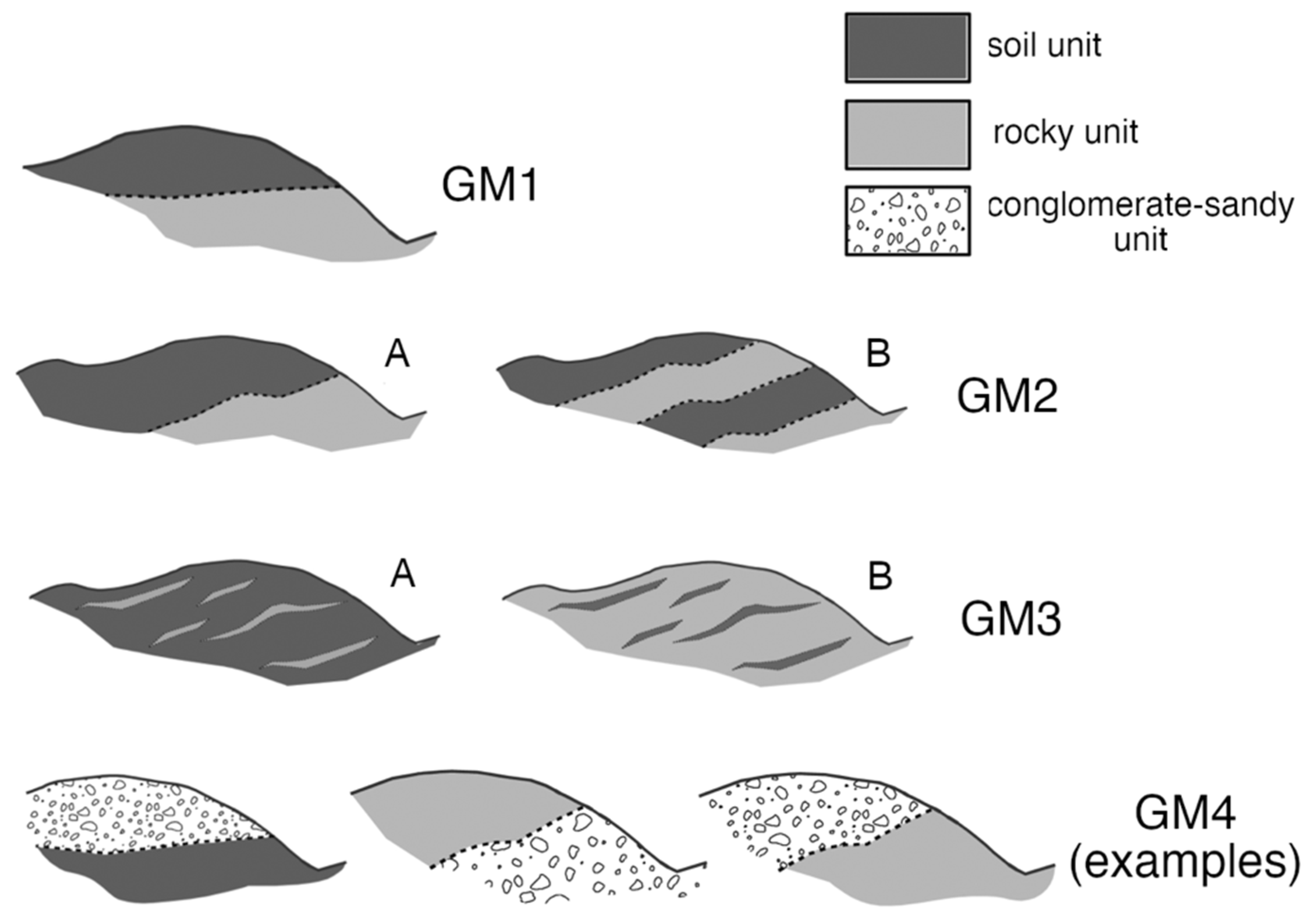
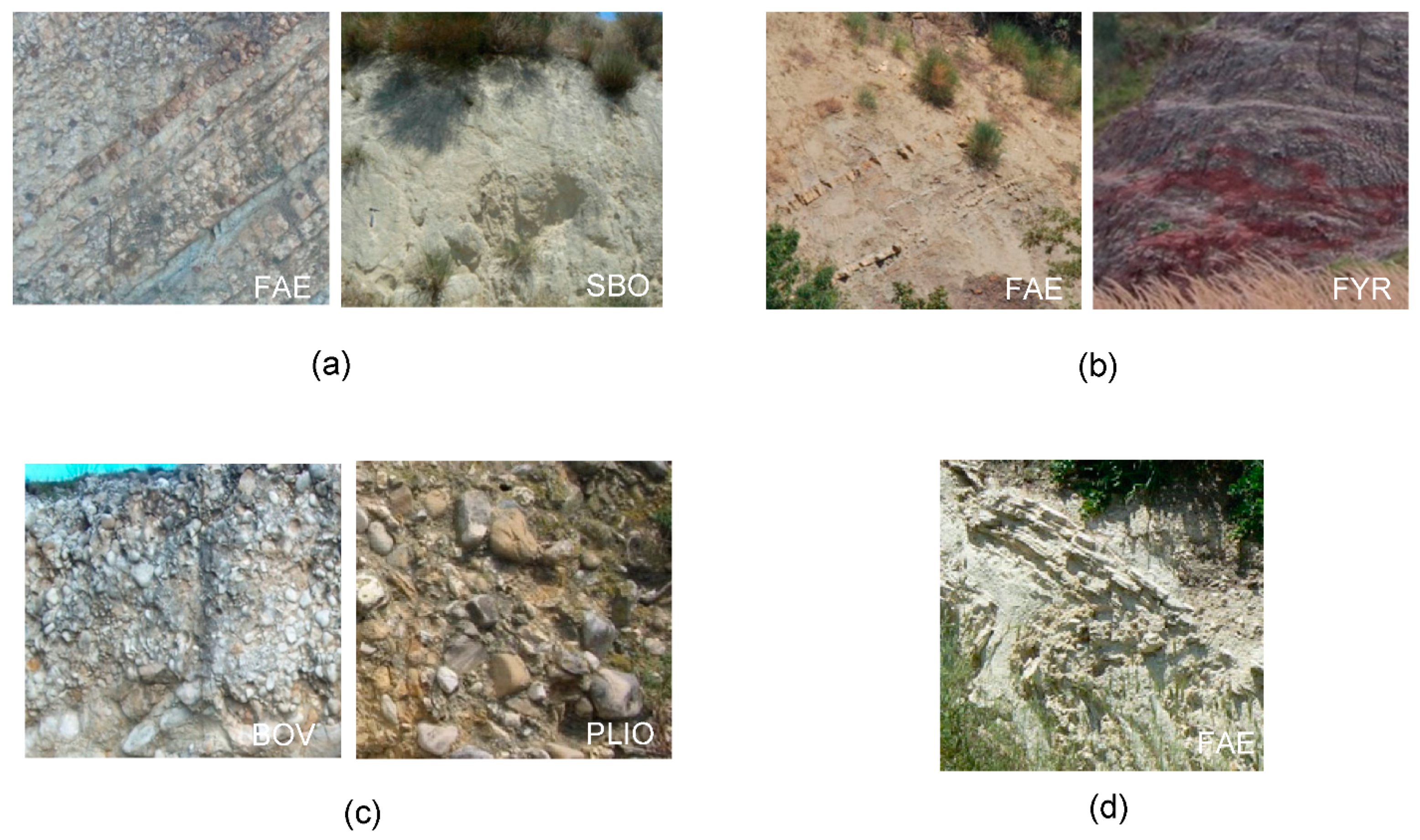
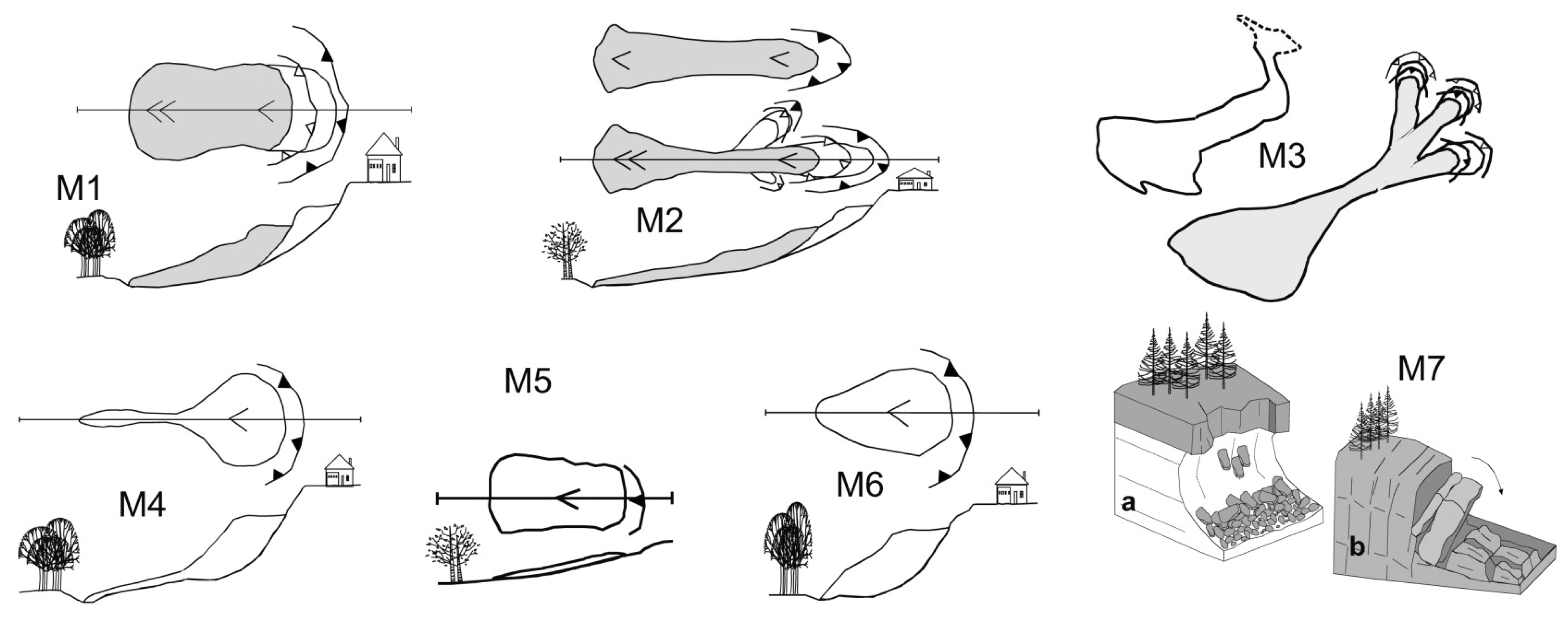
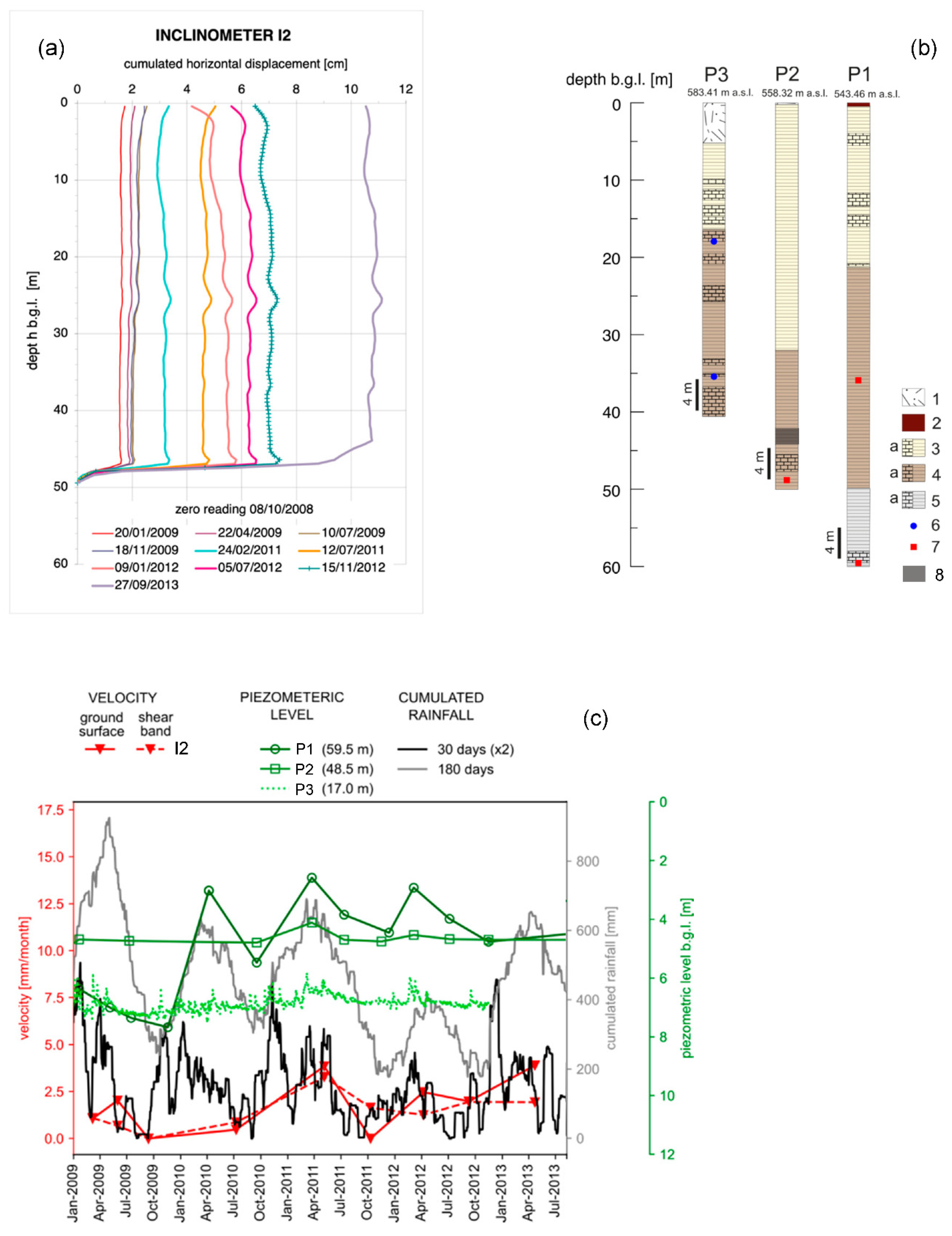
2.2. Representative Geo-Hydro-Mechanical Setups of Faeto Flysch and Landslide Mechanisms Recorded at the Regional Scale
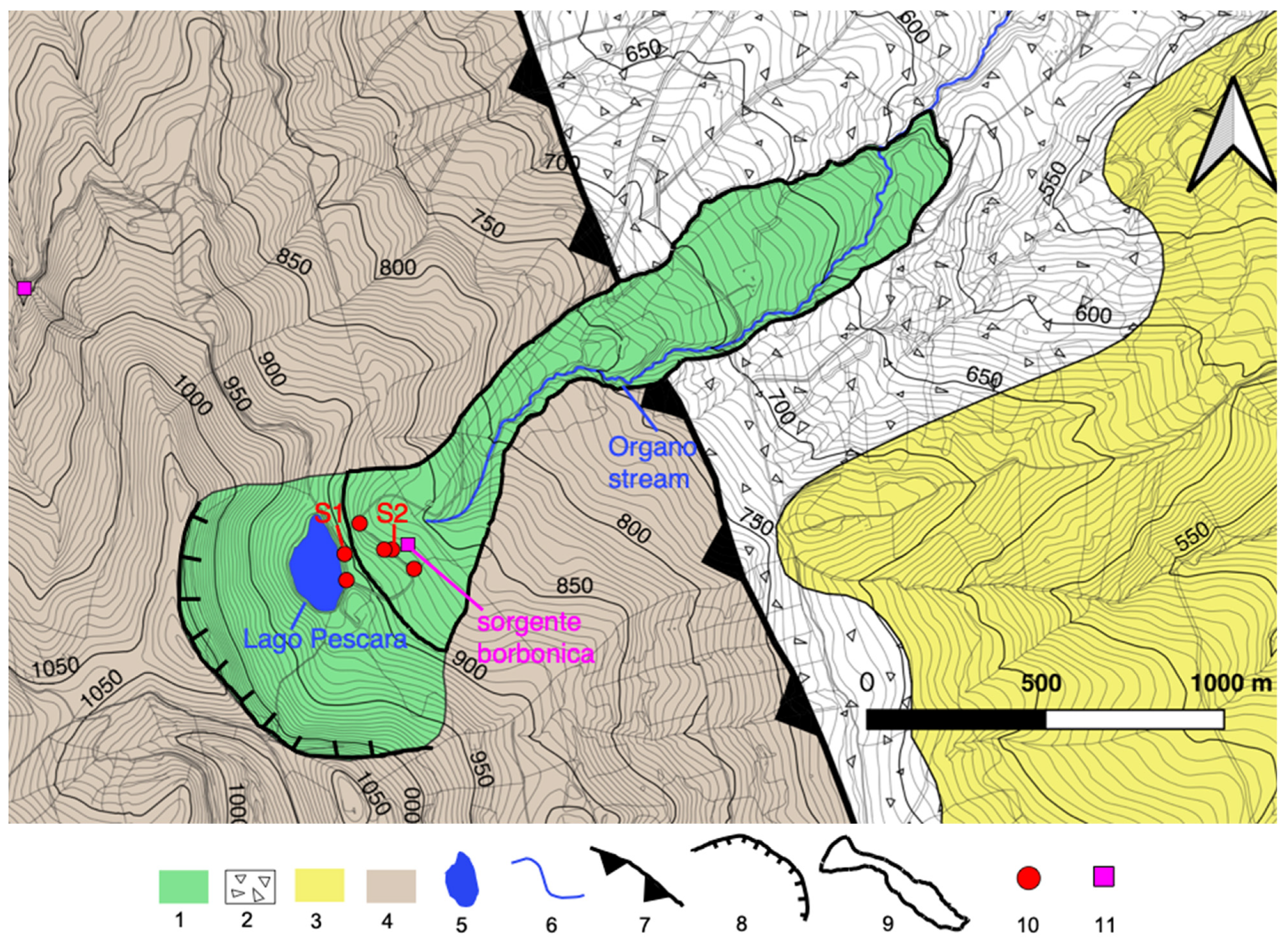
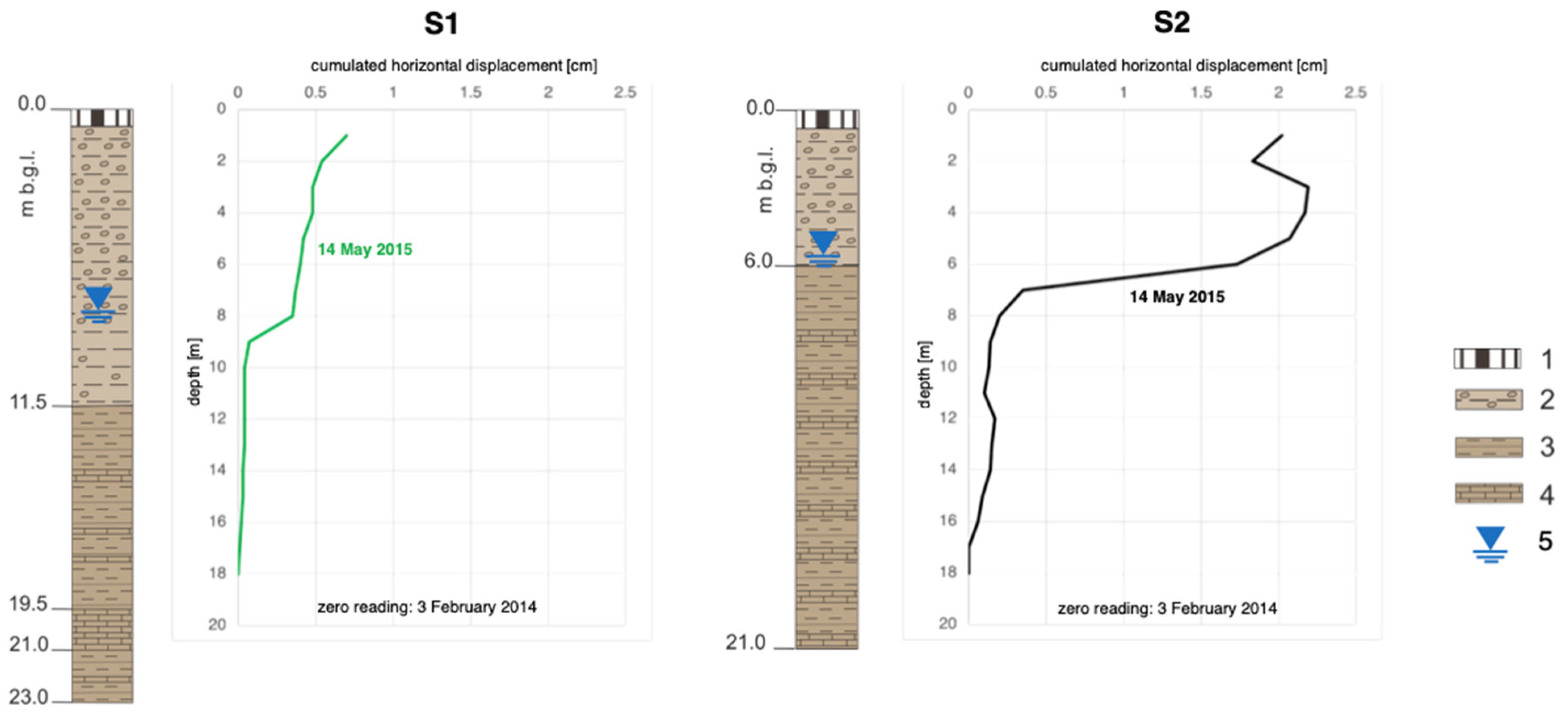
3. Description of the Selected Sites
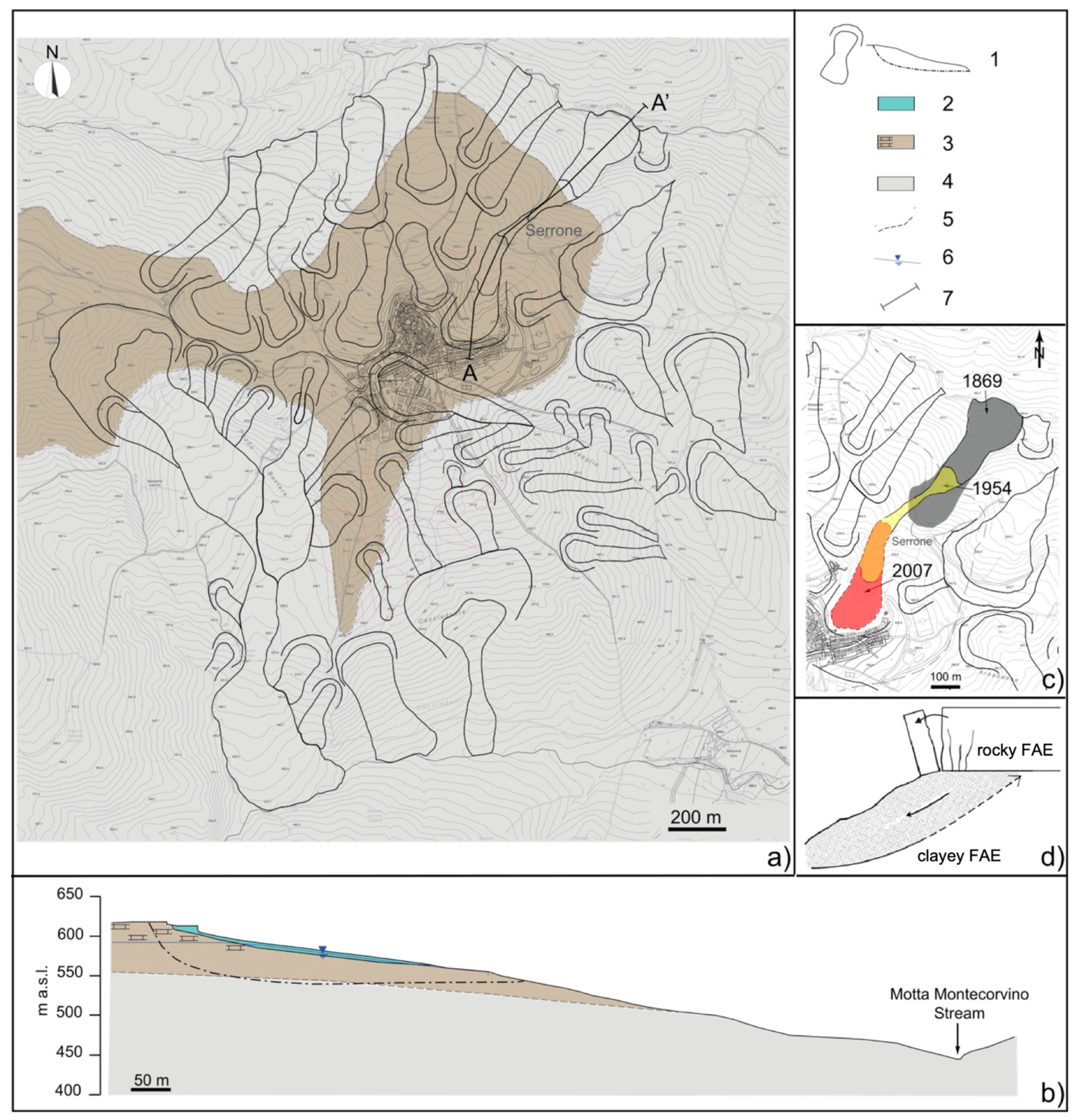
3.1. Motta Montecorvino
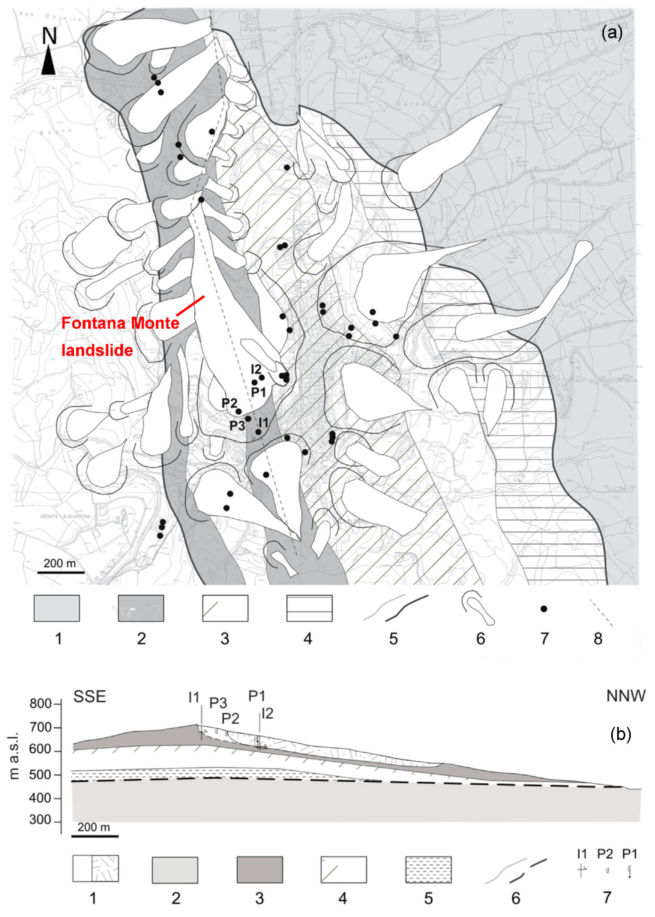
3.2. Volturino
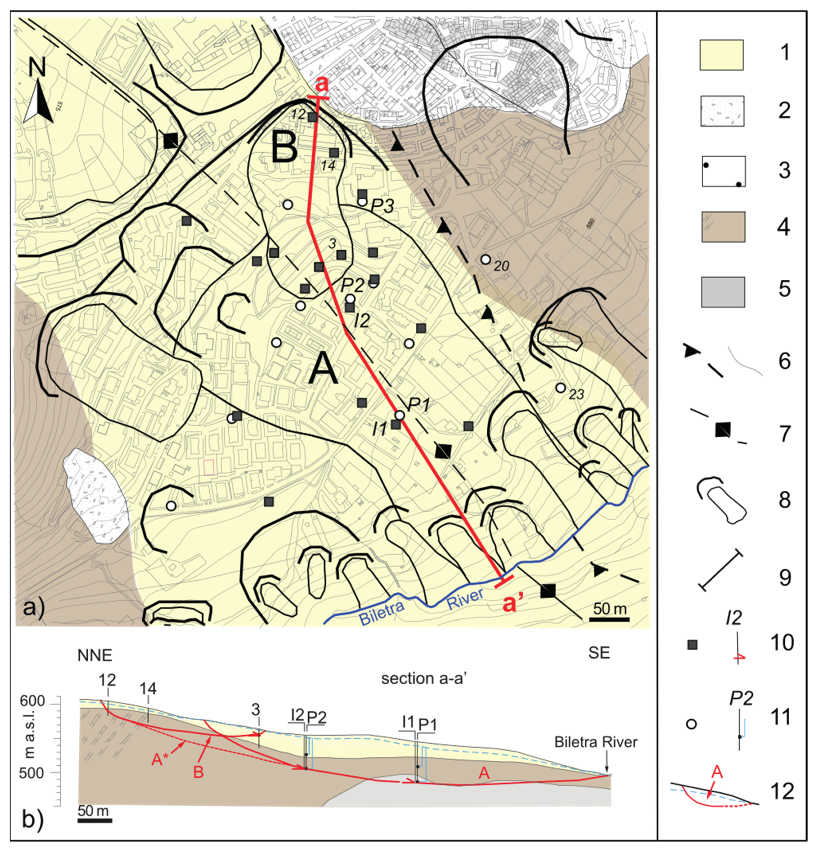
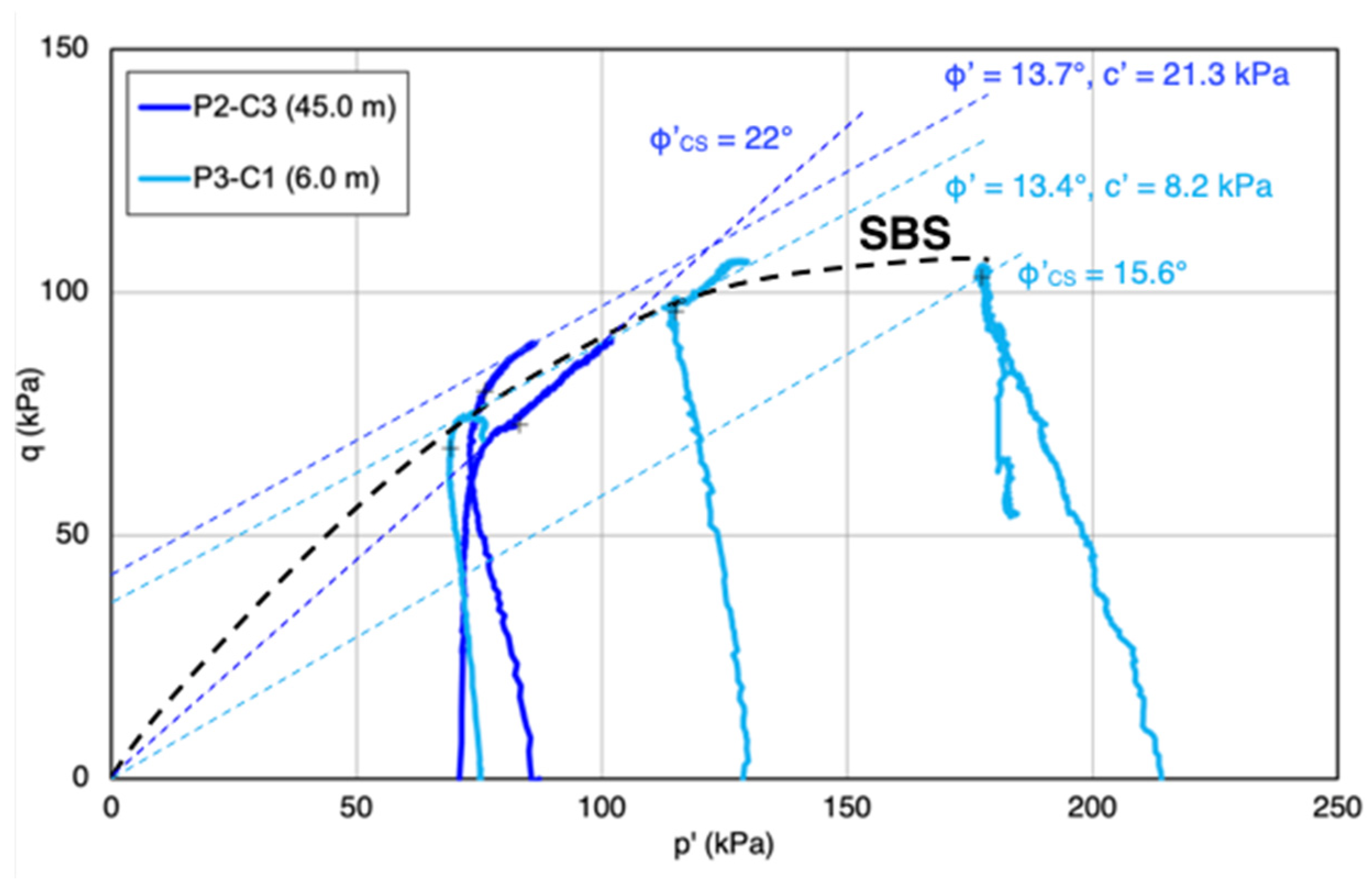
3.3. Bovino
3.4. Biccari
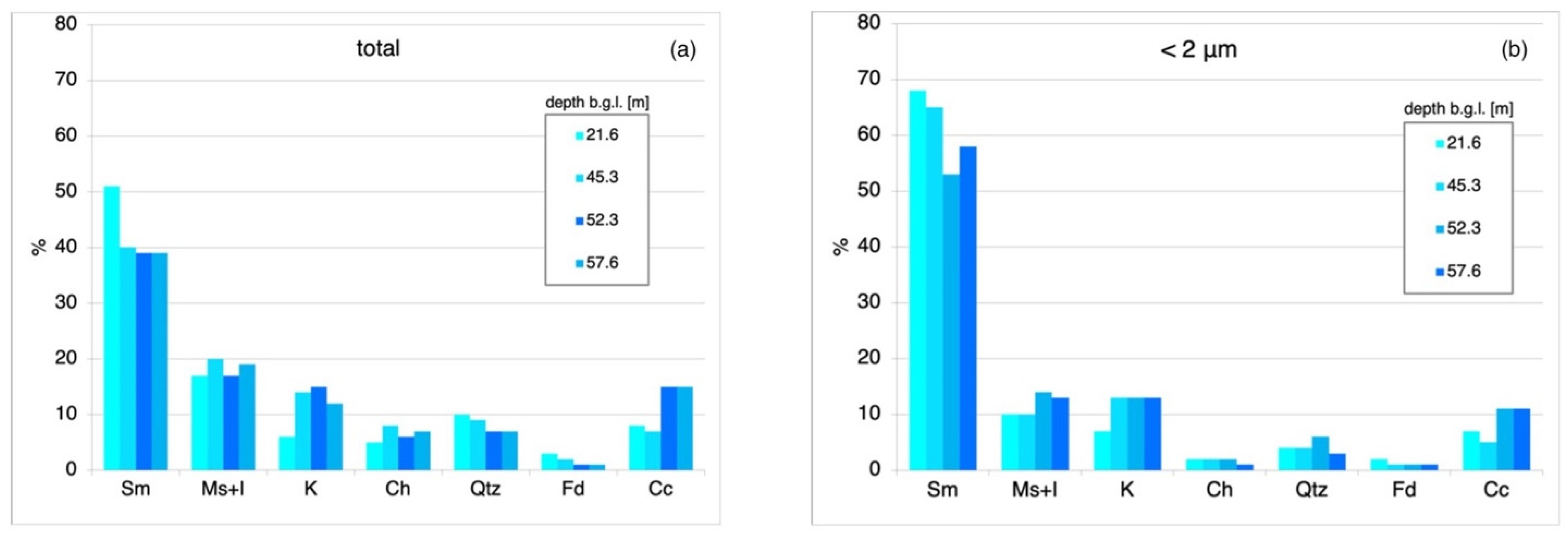
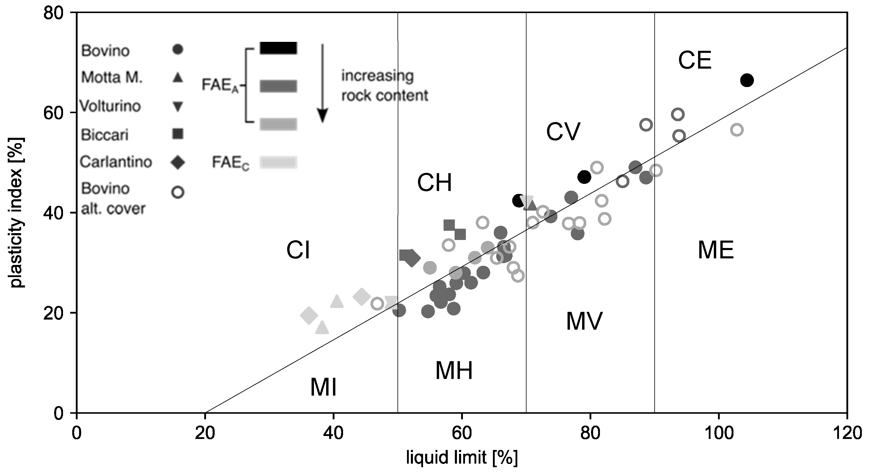
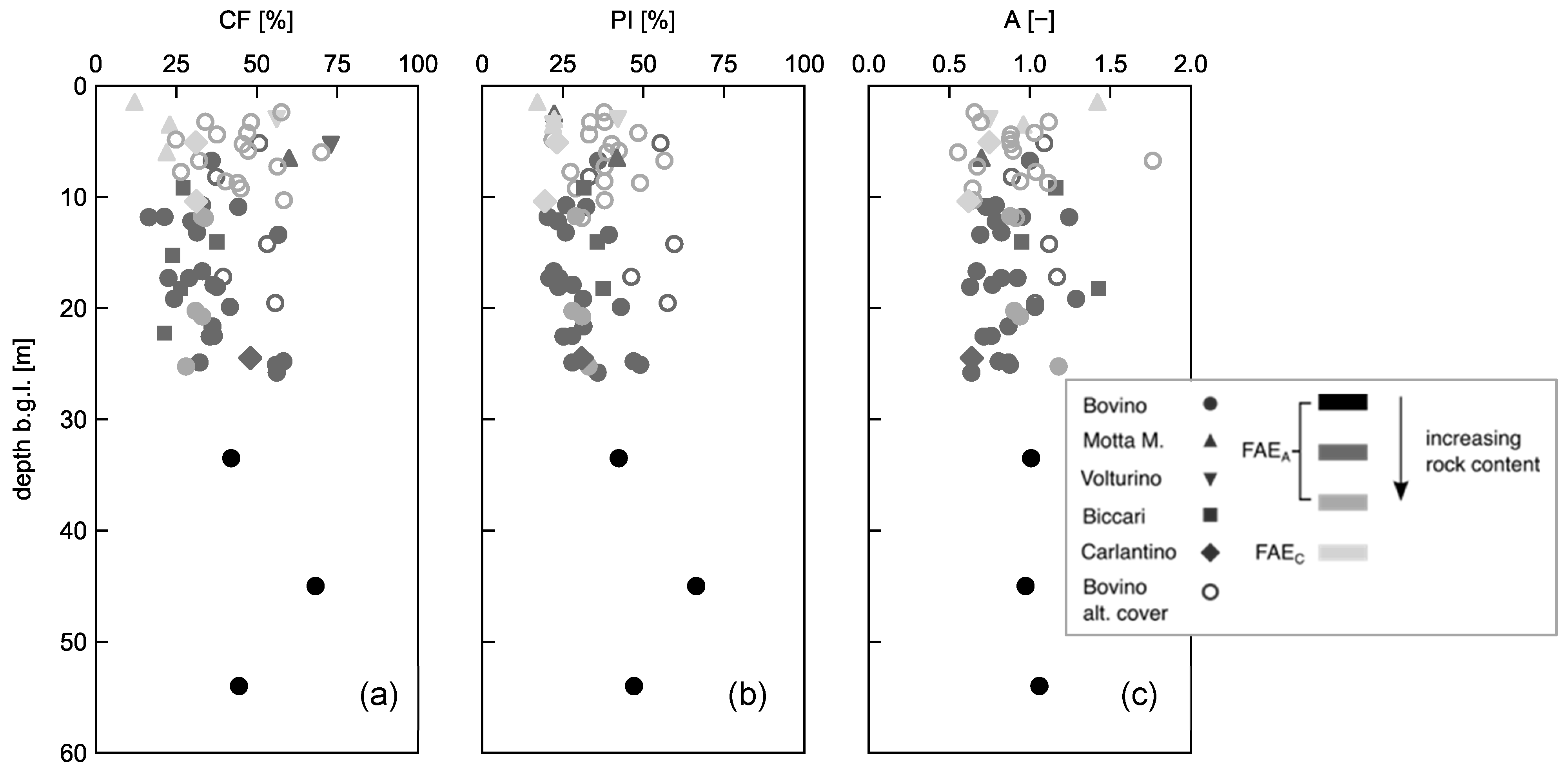
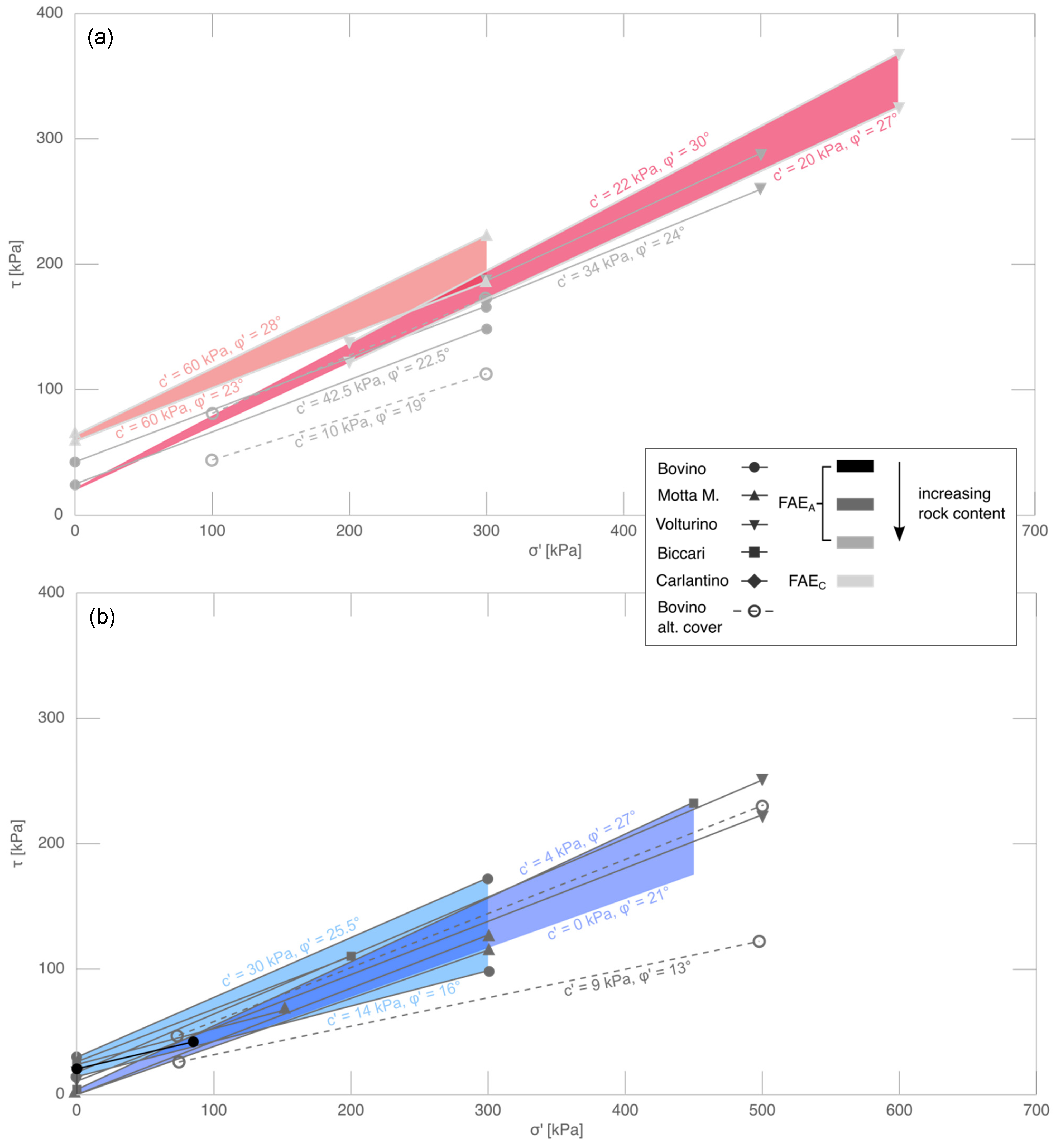
4. Variability of Faeto Flysch Geotechnical Properties
5. Discussion and Conclusions
Author Contributions
Funding
Institutional Review Board Statement
Informed Consent Statement
Data Availability Statement
Conflicts of Interest
References
- Cruden, D.; Varnes, D. Chapter 3—Landslides Types and Processes. In Landslides: Investigation and Mitigation; Transportation Research Board: Washington, DC, USA, 1996. [Google Scholar]
- Cotecchia, F.; Santaloia, F.; Lollino, P.; Vitone, C.; Mitaritonna, G. Deterministic Landslide Hazard Assessment at Regional Scale. In Proceedings of the GeoFlorida 2010: Advances in Analysis, Modeling & Design, Orlando, FL, USA, 20–24 February 2010; pp. 3130–3139. [Google Scholar]
- Terzaghi, K. Mechanism of Landslides. In Application of Geology to Engineering Practice; Paige, S., Ed.; Geological Society of America: Boulder, CO, USA, 1950. [Google Scholar]
- Croce, A. Opening adress. In Proceedings of the International Symposium: The Geotechnics of Structurally Complex Formations, Capri, Italy, 19–21 September 1977; Volume II, pp. 148–151. [Google Scholar]
- Fenelli, G.; Paparo Filomarino, M.; Picarelli, L.; Rippa, F. Proprietà Fisiche e Meccaniche Di Argille Varicolori Dell’Irpinia. Riv. Ital. Geotec. 1982, 3, 110–124. [Google Scholar]
- Pellegrino, A.; Picarelli, L. Contributo Alla Caratterizzazione Geotecnica Di Formazioni Argillose Intensamente Tetonizzate. Geol. Appl. E Idrogeol. 1985, 20, 155–192. [Google Scholar]
- Santaloia, F.; Cotecchia, F.; Polemio, M. Mechanics of a Tectonized Soil Slope: Influence of Boundary Conditions and Rainfall. Q. J. Eng. Geol. Hydrogeol. 2001, 34, 165–185. [Google Scholar] [CrossRef] [Green Version]
- Cotecchia, F.; Santaloia, F.; Vitone, C.; Cafaro, F. The mechanical behaviour of intensely fissured high plasticity clays from Daunia. In Characterisation and Engineering Properties of Natural Soils; Phoon, K., Hight, D., Leroueil, S., Tan, T., Eds.; CRC Press: London, UK, 2007. [Google Scholar]
- Cotecchia, F.; Vitone, C.; Santaloia, F.; Pedone, G.; Bottiglieri, O. Slope Instability Processes in Intensely Fissured Clays: Case Histories in the Southern Apennines. Landslides 2015, 12, 877–893. [Google Scholar] [CrossRef]
- Silvestri, F.; Vitone, C.; d’Onofrio, A.; Cotecchia, F.; Puglia, R.; de Magistris, F. The influence of meso-structure on the mechanical behaviour of a marly clay from low to high strains. In Soil Stress-Strain Behavior: Measurement, Modeling and Analysis; Springer: Heidelberg, Germany, 2007; pp. 333–350. [Google Scholar]
- Nardelli, V.; Coop, M.; Vitone, C.; Chen, S. The Inter-Scale Behaviour of Two Natural Scaly Clays. Géotech. Lett. 2016, 6, 205–210. [Google Scholar] [CrossRef] [Green Version]
- Vitone, C.; Cotecchia, F.; Federico, A.; Viggiani, G. On the Geomechanical Characterisation of Complexities in Clays: Experimental Studies. Riv. Ital. Geotec. 2018, 2, 1–29. [Google Scholar]
- Vitone, C.; Guglielmi, S.; Pedone, G.; Cotecchia, F. Effects of Micro- to Meso-Features on the Permeability of Fissured Clays. Géotechnique Lett. 2019, 9, 369–376. [Google Scholar] [CrossRef]
- Cotecchia, F.; Pedone, G.; Bottiglieri, O.; Santaloia, F.; Vitone, C. Slope-Atmosphere Interaction in a Tectonized Clayey Slope: A Case Study. Riv. Ital. Geotec. 2014, 1, 28. [Google Scholar]
- Cotecchia, F.; Petti, R.; Milella, D.; Lollino, P. Design of Medium Depth Drainage Trench Systems for the Mitigation of Deep Landsliding. Geosciences 2020, 10, 174. [Google Scholar] [CrossRef]
- Cotecchia, F.; Santaloia, F.; Tagarelli, V. Towards A Geo-Hydro-Mechanical Characterization of Landslide Classes: Preliminary Results. Appl. Sci. 2020, 10, 7960. [Google Scholar] [CrossRef]
- Palmisano, F.; Vitone, C.; Cotecchia, F. Methodology for Landslide Damage Assessment. Procedia Eng. 2016, 161, 511–515. [Google Scholar] [CrossRef] [Green Version]
- Palmisano, F.; Vitone, C.; Cotecchia, F. Assessment of Landslide Damage to Buildings at the Urban Scale. J. Perform. Constr. Facil. 2018, 32, 04018055. [Google Scholar] [CrossRef]
- Tagarelli, V.; Cotecchia, F. Deep Movements in Clayey Slopes Relating to Climate: Modeling for Early Warning System Design. In Proceedings of the Geotechnical Research for Land Protection and Development; Calvetti, F., Cotecchia, F., Galli, A., Jommi, C., Eds.; Springer International Publishing: Cham, Switzerland, 2020; pp. 205–214. [Google Scholar]
- Cotecchia, F.; Tagarelli, V.; Pedone, G.; Ruggieri, G.; Guglielmi, S.; Santaloia, F. Analysis of Climate-Driven Processes in Clayey Slopes for Early Warning System Design. Proc. Inst. Civ. Eng. Geotech. Eng. 2019, 172, 465–480. [Google Scholar] [CrossRef]
- Tagarelli, V.; Cotecchia, F. The Effects of Slope Initialization on the Numerical Model Predictions of the Slope-Vegetation-Atmosphere Interaction. Geosciences 2020, 10, 85. [Google Scholar] [CrossRef] [Green Version]
- Cotecchia, F.; Santaloia, F.; Lollino, P.; Vitone, C.; Pedone, G.; Bottiglieri, O. From a Phenomenological to a Geomechanical Approach to Landslide Hazard Analysis. Eur. J. Environ. Civ. Eng. 2016, 20, 1004–1031. [Google Scholar] [CrossRef]
- Lollino, P.; Cotecchia, F.; Elia, G.; Mitaritonna, G.; Santaloia, F. Interpretation of Landslide Mechanisms Based on Numerical Modelling: Two Case-Histories. Eur. J. Environ. Civ. Eng. 2016, 20, 1032–1053. [Google Scholar] [CrossRef]
- Elia, G.; Cotecchia, F.; Pedone, G.; Vaunat, J.; Vardon, P.J.; Pereira, C.; Springman, S.M.; Rouainia, M.; Van Esch, J.; Koda, E.; et al. Numerical Modelling of Slope–Vegetation–Atmosphere Interaction: An Overview. Q. J. Eng. Geol. Hydrogeol. 2017, 50, 249–270. [Google Scholar] [CrossRef] [Green Version]
- Cotecchia, F.; Santaloia, F.; Pedone, G.; Vitone, C.; Lollino, P.; Mitaritonna, G. Diagnosis of Slow Landslides Affecting Tectonised Clayey Slopes (Southern Apennines). In Engineering Geology for Society and Territory; Lollino, G., Giordan, D., Crosta, G.B., Corominas, J., Azzam, R., Wasowski, J., Sciarra, N., Eds.; Springer International Publishing: Cham, Switzerland, 2015; Volume 2, pp. 1029–1032. [Google Scholar]
- Melidoro, A.; Melidoro, G.; Panaro, V. Deformazioni Gravitative Dei Versanti Nei Terreni Flisciodi Con Argille a Bentoniti Di Santa Croce Di Magliano (Molise). Quarry Constr. 2002, 2, 11–17. [Google Scholar]
- Giordan, D.; Allasia, P.; Manconi, A.; Baldo, M.; Santangelo, M.; Cardinali, M.; Corazza, A.; Albanese, V.; Lollino, G.; Guzzetti, F. Morphological and Kinematic Evolution of a Large Earthflow: The Montaguto Landslide, Southern Italy. Geomorphology 2013, 187, 61–79. [Google Scholar] [CrossRef]
- Lollino, P.; Giordan, D.; Allasia, P. The Montaguto Earthflow: A Back-Analysis of the Process of Landslide Propagation. Eng. Geol. 2014, 170, 66–79. [Google Scholar] [CrossRef]
- Lollino, P.; Giordan, D.; Allasia, P.; Pastor, M. Analysis of the Propagation of a Large Earthflow by SPH Technique Application. In Proceedings of the 12th International Symposium on Landslides and Engineered Slopes, Experience, Theory and Practice, Napoli, Italy, 12–19 June 2016; Volume 2, pp. 1313–1321. [Google Scholar]
- Lollino, P.; Giordan, D.; Allasia, P.; Fazio, N.L.; Perrotti, M.; Cafaro, F. Assessment of Post-Failure Evolution of a Large Earthflow through Field Monitoring and Numerical Modelling. Landslides 2020, 17, 2013–2026. [Google Scholar] [CrossRef]
- Cotecchia, V.; Del Prete, M.; Federico, A.; Fenelli, G.; Pellegrino, A.; Picarelli, L. Studio Di Una Colata Attiva in Formazioni Strutturalmente Complesse Presso Brindisi Di Montagna Scalo (PZ). AGI—XVI Conv. Naz. Geotec. 1986, 253–264. [Google Scholar]
- Picarelli, L. Modellazione e Monitoraggio Di Una Colata in Formazioni Strutturalmente Complesse. In Proceedings of the Convegno su Cartografia e Monitoraggio dei Movimenti Franosi, Bologna, Italy, 10–11 November 1988; pp. 119–130. [Google Scholar]
- Bentivenga, M.; Grimaldi, S.; Palladino, G. Caratteri Geomorfologici Della Instabilità Del Versante Sinistro Del Fiume Basento Interessato Dalla Grande Frana Di Brindisi Di Montagna Scalo (Potenza, Basilicata). G. Geol. Appl. 2006, 4, 123–130. [Google Scholar]
- Patacca, E.; Scandone, P. Geology of the Southern Apennines. Boll. Della Soc. Geol. Ital. 2007, 7, 75–119. [Google Scholar]
- Pescatore, T.S.; Di Nocera, S.; Matano, F.; Pinto, F. L’unita Del Fortore Nel Quadro Della Geologia Del Settore Orientale Dei Monti Del Sannio (Appennino Meridionale). Ital. J. Geosci. 2000, 119, 587–601. [Google Scholar]
- Malinverno, A.; Ryan, W.B. Extension in the Tyrrhenian Sea and Shortening in the Apennines as Result of Arc Migration Driven by Sinking of the Lithosphere. Tectonics 1986, 5, 227–245. [Google Scholar] [CrossRef]
- Doglioni, C. A Proposal for the Kinematic Modelling of W-Dipping Subductions-Possible Applications to the Tyrrhenian-Apennines System. Terra Nova 1991, 3, 423–434. [Google Scholar] [CrossRef]
- Scrocca, D.; Carminati, E.; Doglioni, C. Deep Structure of the Southern Apennines, Italy: Thin-Skinned or Thick-Skinned? Tectonics 2005, 24, 1–20. [Google Scholar] [CrossRef]
- Pieri, P.; Gallicchio, S.; De Donato, G.; Festa, V.; Fiore, A.; Moretti, M.; Tilli, A.; Tropeano, M. Carta Geologica d’Italia. Foglio 407 San Bartolomeo in Galdo, Alla Scala 1:50,000; ISPRA: Roma, Italy, 2010.
- Pieri, P.; Gallicchio, S.; Moretti, M.; Ciaranfi, N.; D‘Alessandro, A.; Festa, V.; Maiorano, M.; Tropeano, M.; Maggiore, M.; Walsh, N. Note Illustrative Della Carta Geologica d ‘Italia Alla Scala 1: 50.000, Foglio 407 San Bartolomeo in Galdo; ISPRA: Roma, Italy, 2011.
- Di Nocera, S.; Torre, M. Geologia Dell’area Compresa Tra Deliceto e Scampitella (Appennino Foggiano). Boll. Della Soc. Geol. Ital. 1987, 106, 351–364. [Google Scholar]
- Pescatore, T.; Di Nocera, S.; Matano, F.; Pinto, F.; Quarantiello, R.; Amore, O.; Boiano, U.; Civile, D.; Fiorillo, L.; Martino, C. Geologia Del Settore Centrale Dei Monti Del Sannio: Nuovi Dati Stratigrafici e Strutturali. Mem. Descr. Carta Geol. It. 2008, 77, 77–94. [Google Scholar]
- Ciaranfi, N.; Loiacono, F.; Moretti, M. Note Illustrative Della Carta Geologica d’Italia Alla Scala 1: 50.000, Foglio 408 ‘Foggia’; ISPRA: Roma, Italy, 2011.
- Cafaro, F.; Cotecchia, F.; Santaloia, F.; Vitone, C.; Lollino, P.; Mitaritonna, G. Landslide Hazard Assessment and Judgment of Reliability: A Geomechanical Approach. Bull. Eng. Geol. Environ. 2017, 76, 397–412. [Google Scholar] [CrossRef]
- Hutchinson, J. General Report: Morphological and Geotechnical Parameters of Landslides in Relation to Geology and Hydrogeology. In Proceedings of the International Symposium on Landslides, Lausanne, Switzerland, 15 July 1988; pp. 3–35. [Google Scholar]
- Hungr, O.; Leroueil, S.; Picarelli, L. The Varnes Classification of Landslide Types, an Update. Landslides 2014, 11, 167–194. [Google Scholar] [CrossRef]
- Cotecchia, F.; Mitaritonna, G.; Elia, G.; Santaloia, F.; Lollino, P. Meccanismi Di Frana in Pendii in Argille Dell’Italia Meridionale Ed Effetti Delle Precipitazioni Meteoriche. In Proceedings of the 1st Int Workshop on Landslides: Rainfall Induced Landslide and Nowcasting Models for Early Warning System, Napoli, Italy, 8–10 June 2009; pp. 31–43. [Google Scholar]
- Mezzina, G. Interpretazione della Pericolosità da Frana nel Centro Abitato di Motta Montecorvino (FG). Master’s Thesis, Politecnico di Bari, Bari, Italy, 2007. [Google Scholar]
- Lollino, P.; Elia, G.; Cotecchia, F.; Mitaritonna, G. Analysis of Landslide Reactivation Mechanisms in Daunia Clay Slopes by Means of Limit Equilibrium and FEM Methods. In Proceedings of the GeoFlorida 2010, Orlando, FL, USA, 20–24 February 2010; pp. 3155–3164. [Google Scholar]
- Palmisano, F.; Elia, A. Behaviour of Masonry Buildings Subjected to Landslide-Induced Settlements. Int. J. Struct. Eng. 2014, 5, 93–114. [Google Scholar] [CrossRef]
- Palmisano, F. Rapid Diagnosis of Crack Patterns of Masonry Buildings Subjected to Landslide-Induced Settlements by Using the Load Path Method. Int. J. Archit. Herit. 2016, 10, 438–456. [Google Scholar] [CrossRef]
- Cotecchia, F.; Vitone, C.; Petti, R.; Soriano, I.; Santaloia, F.; Lollino, P. Slow landslides in urbanised clayey slopes: An emblematic case from the south of Italy. In Landslides and Engineered Slopes. Experience, Theory and Practice; CRC Press: Boca Raton, FL, USA, 2018; pp. 691–698. [Google Scholar]
- BSI BS 5930: 2015 Code of Practice for Ground Investigations; British Standards Institution: London, UK, 2015.
- Santo, A.; Senatore, M. La Successione Stratigrafica Dell’unita Dauna a Monte Sidone (Castelluccio Valmaggiore-Foggia). Mem. Della Soc. Geol. Ital. 1988, 41, 431–438. [Google Scholar]
- Schofield, A.; Wroth, C. Critical State Soil Mechanics; McGraw-Hill: New York, NY, USA, 1968. [Google Scholar]
- Soriano, I. Advanced Analysis of the Stress-Strain Conditions of Pianello Slope (Bovino, Italy). Master’s Thesis, Politecnico di Bari, Bari, Italy, 2013. [Google Scholar]
- Mazzei, F. Analisi Numerica della Filtrazione in un Pendio in Frana ai Fini di Valutazioni della Stabilità. Master’s Thesis, Politecnico di Bari, Bari, Italy, 2010. [Google Scholar]
- Vezzani, L.; Festa, A.; Ghisetti, F.C. Geology and Tectonic Evolution of the Central-Southern Apennines, Italy; Geological Society of America: Boulder, CO, USA, 2010. [Google Scholar]
- Di Lernia, A.; Cotecchia, F.; Elia, G.; Tagarelli, V.; Santaloia, F. Assessing the influence of hydraulic boundary conditions on clayey slope stability: The Fontana Monte case study. Eng. Geol. 2021, submitted. [Google Scholar]


Publisher’s Note: MDPI stays neutral with regard to jurisdictional claims in published maps and institutional affiliations. |
© 2021 by the authors. Licensee MDPI, Basel, Switzerland. This article is an open access article distributed under the terms and conditions of the Creative Commons Attribution (CC BY) license (https://creativecommons.org/licenses/by/4.0/).
Share and Cite
Losacco, N.; Bottiglieri, O.; Santaloia, F.; Vitone, C.; Cotecchia, F. The Geo-Hydro-Mechanical Properties of a Turbiditic Formation as Internal Factors of Slope Failure Processes. Geosciences 2021, 11, 429. https://doi.org/10.3390/geosciences11100429
Losacco N, Bottiglieri O, Santaloia F, Vitone C, Cotecchia F. The Geo-Hydro-Mechanical Properties of a Turbiditic Formation as Internal Factors of Slope Failure Processes. Geosciences. 2021; 11(10):429. https://doi.org/10.3390/geosciences11100429
Chicago/Turabian StyleLosacco, Nunzio, Osvaldo Bottiglieri, Francesca Santaloia, Claudia Vitone, and Federica Cotecchia. 2021. "The Geo-Hydro-Mechanical Properties of a Turbiditic Formation as Internal Factors of Slope Failure Processes" Geosciences 11, no. 10: 429. https://doi.org/10.3390/geosciences11100429
APA StyleLosacco, N., Bottiglieri, O., Santaloia, F., Vitone, C., & Cotecchia, F. (2021). The Geo-Hydro-Mechanical Properties of a Turbiditic Formation as Internal Factors of Slope Failure Processes. Geosciences, 11(10), 429. https://doi.org/10.3390/geosciences11100429