Review

Integrated Stratigraphy of the Marine Early Pleistocene in Umbria

Department of Physics and Geology, University of Perugia, Via A. Pascoli, 06123 Perugia, Italy
*
Author to whom correspondence should be addressed.
Geosciences 2020, 10(9), 371; https://doi.org/10.3390/geosciences10090371
Submission received: 12 August 2020 / Revised: 11 September 2020 / Accepted: 14 September 2020 / Published: 17 September 2020
(This article belongs to the Special Issue Quaternary Sedimentary Successions)

Abstract

:
Through time, the wide area between southeastern Tuscany, northeastern Latium, and western Umbria has been revealed as a crucial area for understanding the evolution of Neogene basins in northern Apennine. In this study, the results of twenty years of research on the marine early Pleistocene deposits are summarized, and the biological and physical events are presented and discussed in order to propose an integrated stratigraphic scheme. The proposed reconstruction is also included in a wider context, taking into account both the local and regional geological evolution.

1. Introduction

The Neogene–Quaternary geological evolution of the wider area between western Umbria, southeastern Tuscany, and northeastern Latium (Figure 1 and Figure 2) appears well outlined, from the onset of a marine basin (the Valdichiana Basin) during the Early Pliocene to the continental-shallow coastal marine phase (Early Pliocene–Early Pleistocene), and finally to the wide continentalization, with volcanic episodes, and the setup of lacustrine basins, from the early–middle Pleistocene onwards, that led to the current river valley setup [1,2,3,4,5,6].
In fact, geological and stratigraphic reconstruction throughout the Pliocene and Pleistocene deposits in western Umbria resumes more than one hundred years of study, and it fits in the comprehensive geological evolution of Neogene extensional basins in northern Apennines [4,7,8,9,10,11,12].
Through the last two decades, Pliocene to Quaternary marine deposits from the Tyrrhenian to the Adriatic sides of Italy, as well as their heterotopic continental deposits, were often merged in a single stratigraphic unit (FAA–Blue Clay Fm. [9]): nonetheless, the high local variability indicates that each basin, or macro-area, had its own geological evolution [6,7]. In fact, this evolution results from a complex interaction between extensional and compressional tectonic regimes during the eastward migration of the Apennines, and between tectonics and sea-level change [4,7,8,9,10,11,12].
Since the19th-century pioneer studies, and through the first draft of the geological map, the geological and stratigraphic framework has gradually changed in line with the progress of scientific knowledge [13]. During the last two decades, indeed, studies allow refining the sedimentological and stratigraphic scenery for the Pliocene–Pleistocene nearshore deposits in the area, and well-defined paleoenvironmental and sedimentation models emerged [13,14,15,16,17,18,19,20,21]. Nonetheless, how the inhered coastal paleomorphologies, the active tectonics, and the sea-level fluctuations may have influenced the facies distribution is still debated. Within this compelling scenario, here, we try to include all the evidence collected over the years into a comprehensive, integrated stratigraphic scheme.

1.1. Previous Studies

According to former authors, the ancient Tyrrhenian Sea crept inside the western Umbrian territory, overflowing a wide area, until it touched the mountain flanks of the Amerina chain, in two separate times: about 3 Ma ago during the late Pliocene, and between 2 and 1.6 Ma during the early Pleistocene. Thus, also including continental deposits, at least three main transgressive–regressive, 3rd-order depositional cycles were hypothesized [22].
Although still widely accredited, this reconstruction showed many inconsistencies, and several biases were pointed out [13,14,15,16,17,18,19,20,21]. The former stratigraphic schemes [1,2,5,6,13,19,20,21,22,23,24,25,26,27,28,29,30,31,32,33,34] are summarized in Figure 3.
Through time, different names have been used to indicate the same geological unit, boundaries have been often reconsidered, and age has often been recalibrated according to global chronostratigraphy [35] and Mediterranean biostratigraphy [36,37,38,39]. For a punctual description, please refer to cited articles. Such apparent complexity is often misleading, and the common point is the identification of the aforementioned three main depositional cycles. The oldest cycle was usually considered late Pliocene in age [22,24,25]; it reasonably follows the Early Pliocene marine transgression, although the base has been never documented in an outcrop. A recent geological mapping project [6] also proposed a Zanclean age for part of thedeposits, although this datum cannot be directly verified. The regressive trend was also underlined by the informal subdivision in lithostratigraphic units [22,24,25]. Lowermost clay deposits were considered the oldest exposed unit in the area; microfossils dated it to the lowermost part of the late Pliocene. Age attribution was confirmed by the occurrence, interleaved with marine clays, of deposits of fluvio-lacustrine deposits, which have been reported near Camorena and Fabro and referred to Triversa Faunal Unit (F.U.) [31,32,33]. Continental deposits (Figure 3) are also intermingled with marine units in the Cetona area [28,34]. All these units refer to a coastal marine depositional environment, from the shoreline to the offshore, and they were influenced both by the proximity of rocky coasts and by the presence of river mouths. With the early Pleistocene, a new marine cycle begins in the area, which is represented by marine to brackish clayey to sandy deposits (Figure 3) [22,24,25]. This unit encompasses the high lateral and vertical variability of deposits in the study area, from marine to brackish/transitional, to continental deposits [20,22]. An increasing complexity was noted both southeastwards [22] and northwards [15], which was due to the presence of deltaic deposits. The progressive withdrawal of the sea isolated some areas, creating restricted basins in which fluvial and fluvio-lacustrine deposits were formed, with late Villafranchian (Olivola-Tasso F.U.) oligotypic freshwater faunas and continental malacofaunas and vertebrates [13,19,21,22] locally mixed with vulcanites [13,26,40]. The 3rd cycle, middle to late Pleistocene in age, is represented by mixed sedimentary and volcanic units [18], especially south of Orvieto, where the products of the volcanic activities of Cimini, Sabatini, and Vico are widespread, as well as by the lacustrine deposits of “Paleo Trasimeno” [5,30]. In the study area, it corresponds to the main volcanic activity of the Vulsini Mts., whose products buried a large part of the territory, before being shaped in the current morphologies.

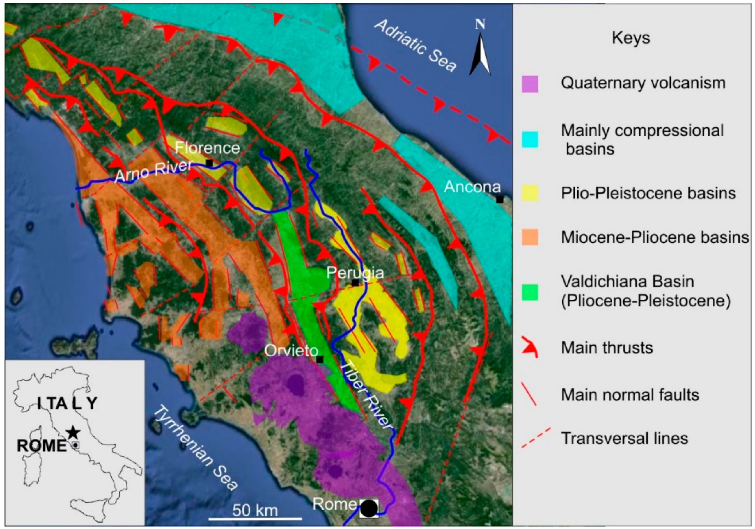
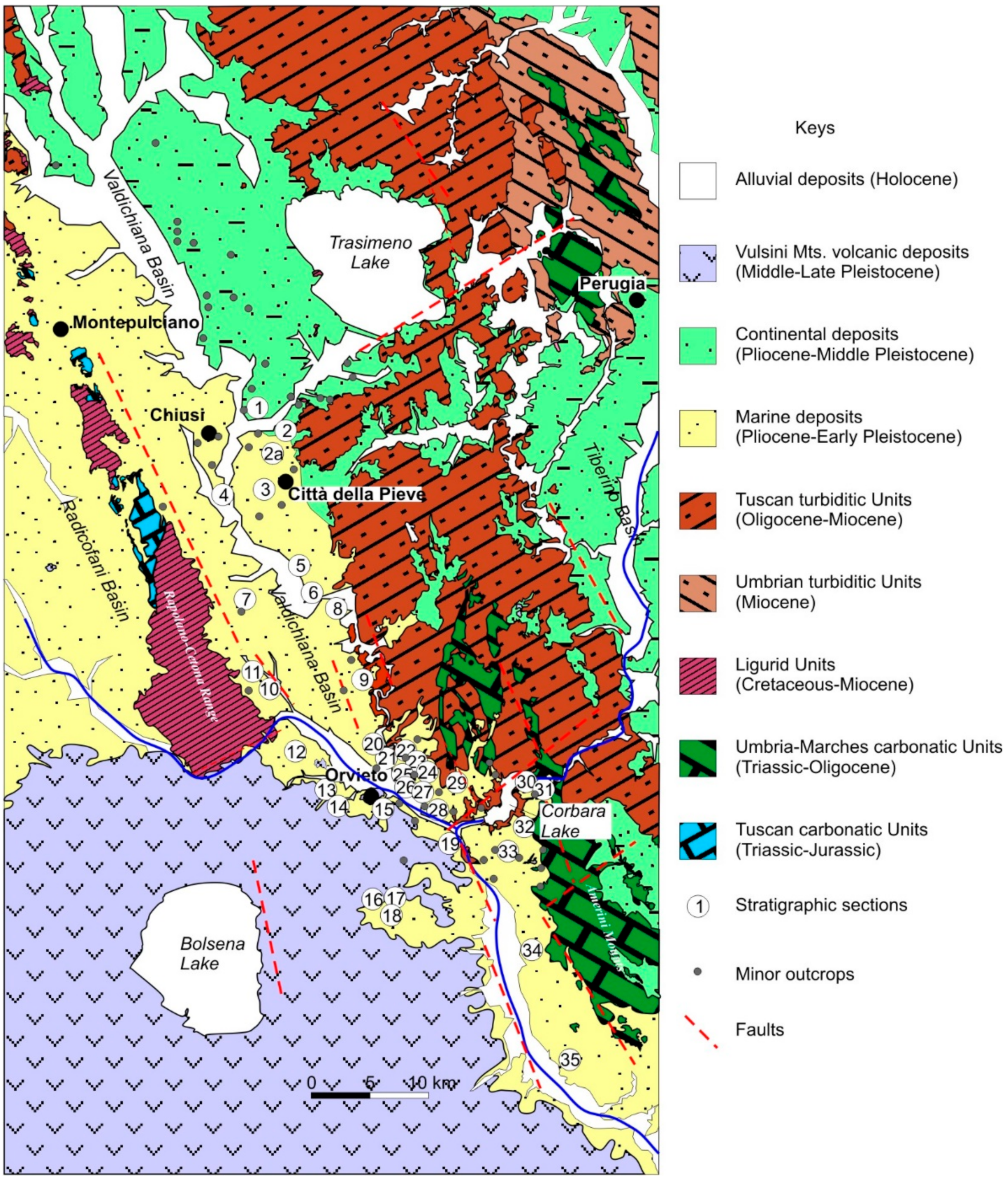
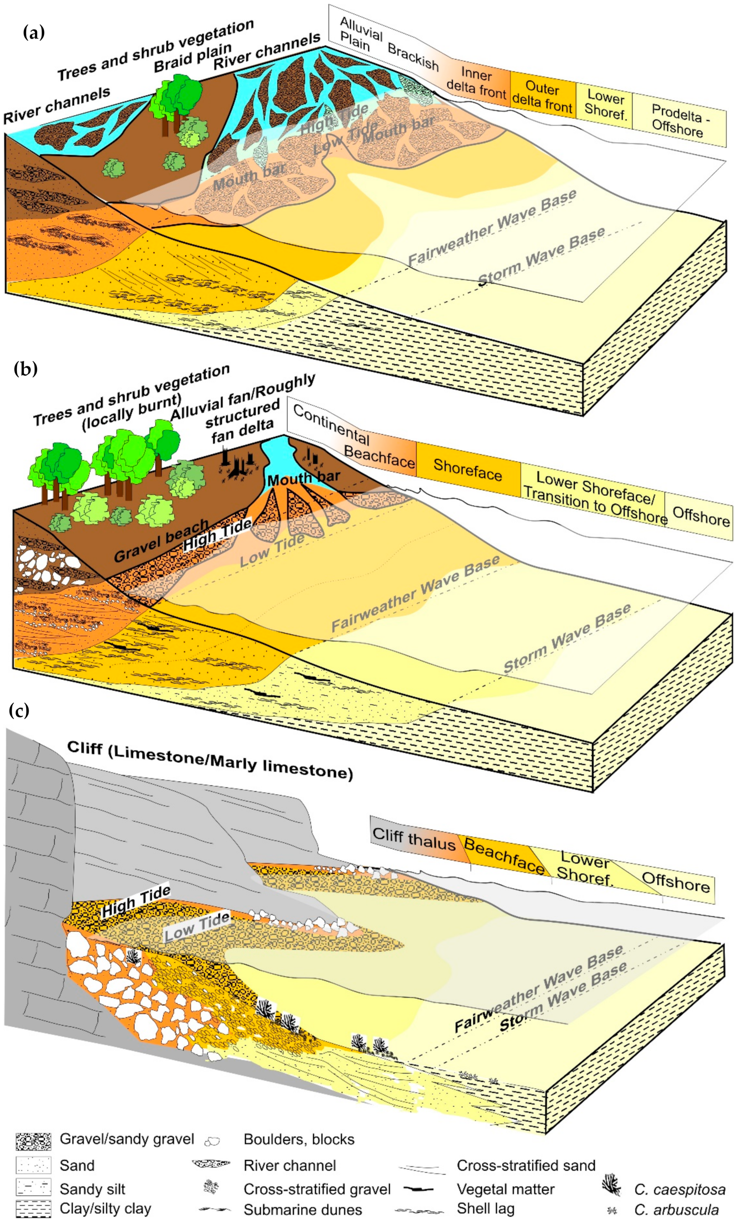
1.2. Geological Setting and Sedimentological Overview

The South Valdichiana Basin (Miocene–Pleistocene) is a narrow NW–SE oriented trench bounded by extensional faults, enclosed between Mesozoic and Cenozoic reliefs (the Rapolano–Cetona and the Narnese–Amerina Apennine ridges), with their Triassic to Miocene Tuscan/Ligurid and Umbria–Marches lithostratigraphic successions [1,2,3,23,41]. The basin occupied a wide area between southeastern Tuscany and western Umbria (central Italy), matching with a present-day area extended at least from the Trasimeno Hills northwards, to Orte southwards, to Bolsena lake southwestwards (Figure 2), and, between the early Pliocene and early Pleistocene, itwas infilled by both marine and continental deposits.
By analyzing the Neogene–Quaternary deposits filling the basin, the geological–stratigraphic pattern looks almost straight (Figure 2). Continental deposits are mainly concentrated to the north, in the hills west of Trasimeno Lake, and in some smaller basins to the east (Tavernelle–Pietrafitta Basin, Parrano–Frattaguida Basin, etc.). Southwards, coastal marine deposits prevail, becoming gradually more distal both in the inner partof the basin and toward the south and southwest. In the latter area, most of the deposits arecovered by extensive volcanic products related to the Vulsini activity.
By means of sedimentology, several vertical and lateral variations were observed, and a very articulated paleogeographic framework emerged (Figure 4), mainly referable to a coastal marine sedimentary environment, varying from cliff systems (close to the Narnese–Amerina chain) to beach and delta systems (Città della Pieve and Orvieto sectors) [13,14,15,16,17,18,19,20,21]. These variations reflect the original articulation of the paleocoast: at least during the early Pleistocene (Gelasian-Calabrian), when the area was probably a large gulf [20], which received only local contributions from rivers (Figure 4). Even in the Pliocene, the appearance should not have been too different [14,31,42]; it was probably different only in the distribution and wideness of zones reached by marine ingression. In the northern area, this assumption finds a possible confirmation in the data from seismic profiles [4] and in the presence of fan-delta deposits (conglomerates of “La Foce”) at the margin with the Radicofani Basin [28], which are presumably fed by an ancient Valdichiana fluvial system.

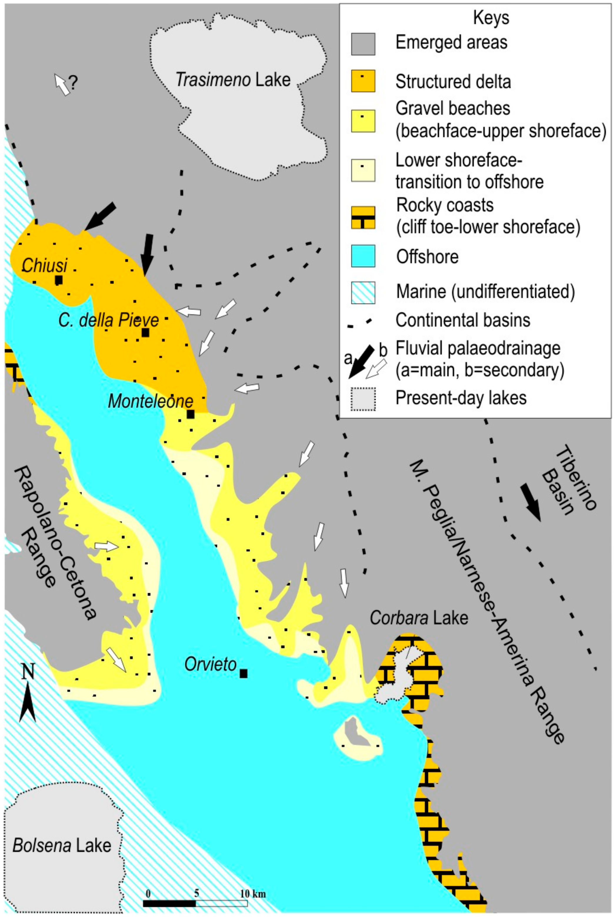
1.2.1. The Delta Environment and Its Continental Supply (Late Pliocene–Early Pleistocene)

The paleoenvironmental evolution of the area between Chiusi, Città della Pieve, and Monteleone d’Orvieto (Figure 2 and Figure 5a) can be more strictly related to a deltaic environment [15]. Facies associations document a deltaic coast fed by a structured and long-lasting river system that built a shallow water, wave-dominated delta fed by a complex of widely extended braided river patterns mainly situated northeast of Città della Pieve, with minor sediment contributions from the east. The depositional architecture led us to hypothesize a delta profile gently inclined seawards [15,20,43]. As it was fed by one or, more probably, several braided rivers, the definition of “braid-plain delta” seems adequate [15]. Organization of both an inner and outer delta front presumably records a high cyclicity of alternate river- and wave-dominated phases (see Section 2.3.). Evidence of a widespread marine transgression, causing the change of river and alluvial plain patterns and the starvation of deltaic systems, were recorded at the top of the succession, as well as in other sites along the present-day Valdichiana and the western Trasimeno Hills (Figure 2) [5,14,30,44,45]. At this time, probably the two areas, northwards and southwards respectively, started evolving separately.

1.2.2. The Gravel Beach Systems and Their Feeding River Mouths (Late Pliocene–Early Pleistocene)

Most of the deposits have been referred to a wave-dominated coastal environment, where sediments of fluvial origin were redistributed along- and across-shore by waves and currents, producing a progressive facies heterotopy [14,20]. Local alluvial fan/fan deltas were also recognized as minor river mouths [14,20] (Figure 2 and Figure 5b). As for the main delta environment, the gently inclination seaward matches well with a shelf-type fan delta model [46,47]. Water depth varied from less than 5 m (submerged gravel beaches), up to 25 m (shoreface); depths from −20/−25 m to −55/−60 m were the range of the transition-to-offshore [20].

1.2.3. The Rocky Coasts (Late Pliocene–Early Pleistocene)

Along the southern Narnese–Amerina Range (Figure 2 and Figure 5c) and the median sector of Cetona Mount, these river-related environments are replaced by facies associations associated to a rocky coast [14,16,20,22,48]. Facies vary from cliff talus, to gravel beachface, to sandy/biocalcarenitic (Figure 5c) yet, high-order cyclicity was recognized [16]. Facies heterotopy was still noted, with more or less an abrupt transition seawards, which is highly depending on coastal morphology.

1.2.4. The Offshore Environment (Pliocene–Early Pleistocene)

In the central part of the basin, as well as southwestwards, finer deposits related to an offshore environment prevail. The upper bathymetric limits for the offshore were reasonably placed at about −55/−60 m, while depths greater than 100–150 m were not feasible [20,49,50]. Deposits are characterized by grain-size uniformity and the lack of sedimentary structures.

2. Early Pleistocene Events in Western Umbria

Several bio-events and/or geo-events have been identified in the area, by means of micropaleontological and sedimentological analyses, leading to a better characterization of marine and continental paleoenvironments. Although already reported earlier, most of them have not yet been discussed in an overall perspective. Here, their stratigraphic role is reconsidered in order to delineate an eventstratigraphy scheme.
Bio-events are mainly associated to planktonic and benthic foraminifers, and to calcareous nannofossils, and secondarily to other invertebrates and vertebrates. Geo-events were age-calibrated to biostratigraphic schemes. Other “benthonic events” are also considered, although they lack their stratigraphic significance, toward a prevailing palaeoecological meaning. The most relevant are:
  • The first occurrences of Globorotalia inflata and Globigerina cariacoensis [14,17] among planktonic foraminifers;
  • The first local occurrence of the benthic foraminifer Hyalinea balthica [14,17,51];
  • The first occurrences of small and medium-size species of genus Gephyrocapsa, followed by the occurrence of large-size Gephyrocapsa [14,17], in the nannofossil record;
  • The distribution of the scleractinian Cladocora caespitosa [14,16], and the first record of the very rare Cladocora arbuscula, which are both typical inhabitants of relatively cool shallow-water marine environments;
  • The occurrence of peculiar assemblages of lunulitid bryozoans [20];
  • The presence of horizons enriched in benthic foraminifers of the genus Amphistegina [52];
  • The presence of Persististrombus cf. P. coronatus in early Pleistocene deposits, which are previously considered extinct in the Mediterranean area during the late Pliocene [18,53];
  • The recovery of cetacean skeletons in early Pleistocene clay deposits, the identification of fossilized ambergris masses, and the establishment of thenew ichnogenus and ichnospecies Ambergrisichnus alleronae (shallow water whale-fall events) [49,50,54];
  • First documentation of peculiar benthic foraminifers (mainly Vaginulina striatissima) and crustacean decapods assemblages associated to whale falls [54,55];
  • The evidences of early Pleistocene volcanism in the Allerona–Orvieto area (pre-Vulsini volcanic events) [14,51,56,57];
  • The evidences of incipient phases of Vulsini volcanic activity during the early–middle Pleistocene continentalization of the area [13].

2.1. Ecological vs. Stratigraphic Importance of Benthic Populations

Previous stratigraphic schemes largely emphasized the importance of macro- and microbenthic species [24,25]. This practice is highly questionable, and many aspects need to be newly discussed. As well as for the macrobenthos, the microbenthic species are commonly found in marine deposits. A comprehensive scheme putting in relation the distribution of benthic taxa with paleodepths, paleoenvironment, and grain size of the seafloor has beenalready proposed for the study area [20].

2.1.1. Mollusks

Through the last two centuries, the presence of a diversified malacofauna has been pointed out [24,25,58,59]. Various attempts were made in the past to attribute a stratigraphic relevance to selected species [24,25,60], both among gastropods (Conidae, Strombidae) and bivalves (pectinids). In fact, most of taxa hold a too-long temporal distribution, from Miocene to Pleistocene, or they are even extant species. Moreover, benthic mollusc’s distribution is driven by ecological and bathymetric parameters, as well as by the substrate lithology [61,62,63,64,65]. Two specific points, generating bias in the past, need to be remarked here.
  • The “Persististrombus coronatus problem”—similar to other taxa with “Senegal affinity”, the genus “Strombuss.l. was usually considered a “warm guest” in the Mediterranean Sea during the Pliocene and late Pleistocene. The frequent occurrence of Persististrombus coronatus Defrance in the area is well documented [58,59], and it was considered one ofthe determining factors for the attribution of thedeposits to thePliocene [25]. The recent taxonomic revision carried out within the Strombidae family [66,67] led to emphasizing this point of view, with the distinction between Persististrombus latus Gmelin (now also indicated as Thetystrombus latus: late Pleistocene to recent, usually referred to MIS 5 isotopic stage [68]), and P. coronatus (fossil), the latter species being considered extinct in the Mediterranean area at the end of the Piacenzian (2.58 Ma). However, several transition forms between P. coronatus and P. latus have been reported [66]. To reconsider the Strombidae phylogenesis and taxonomy is beyond the aims of this work. Nonetheless, very well-preserved specimens with transitional features and provisionally assigned to Persististrombus cf. P. coronatus were collected in several sections attributed to the Gelasian and Calabrian [18,53], in environmental contexts ranging from offshore to shoreface, up to the mouth and to the channel lag of fan-deltas. These data seem to confirm the survival and/or the evolution of Persististrombus cfr. P. coronatus through the early Pleistocene. Beyond the stratigraphic problems, which need a significant rediscussion, these fossils are paleoenvironmental and paleoecological indicators. They are frequently accompanied by malacofaunas indicative of the infralittoral and upper circalittoral zones[18,20,53]. Equally common is the association with Amphistegina lessonii, A. radiata, and cupuladrid bryozoans [20], which are almost always accompanied by other benthic foraminifers of low depth and/or vegetated bottoms [53] (Elphidium crispum, Ammonia group, Gyroidina altiformis, Lobatula lobatula, etc.). Thus, Persististrombus cf. P. coronatus in the Orvieto area are indicative of warm and shallow waters [20] still during theearly Pleistocene.
  • Stratigraphic vs. ecological distribution of pectinids—In spite of the large number of mollusc species described [24,25,58,59], the species diversity is often low, and several sections are dominated by oysters (Ostrea lamellosa, Ostrea edulis) and pectinids (Pecten jacobaeus, Flabellipecten flabelliformis, Amusium cristatum, and several species of Chlamys). A stratigraphic distribution was proposed [24,25,60]: particularly, the presence of Flabellipecten and Amusium was considered indicative of Pliocene and Pleistocene deposits, respectively. This attribution is misleading: in fact, the substrate-related distribution of pectinids is known [64], and the same situation characterizes deposits in the studyarea [20]. Sand to fine gravel sediments are dominated by P. jacobaeus and F. flabelliformis, while Amusium is very uncommon, the last becoming almost exclusive in clay [20]. Although less evident, a similar trend was noted for Chlamys species. Moreover, these species of pectinids evolved during the Miocene, and they were equally documented in Pliocene and Pleistocene deposits. Thus, the distribution of pectinids is bathymetry- and energy-dependent as well, but it is not stratigraphically significant.

2.1.2. Crustaceans

Although known from the end of 19th century [68], the presence of crustaceans in the area has long been largely ignored. Nonetheless, trace fossils (Thalassynoides, Ophyomorpha) referable to crustacean burrowing have been commonly reported [14,18,19]. Recently, the occurrence of decapods in both shallow water assemblages and relatively deeper whale-fall assemblages was pointed out [19,54,55]. Moreover, the distribution and taxonomy of Ranina propinqua Ristori (1891) has been reconsidered [43,69].
New findings of crustacean decapods, strictly related to shallow water whale-fall events [54,55], documented the occurrence of a highly specialized assemblage characterized by Clinocephalus demissifrons, Albaidaplax hispalensis, and the new species Astenognatus alleronensis.
Most of the species have been elsewhere known in Pliocene deposits, and they are here reported still in the early Pleistocene for the first time.
The area looks promising to better define the taxonomy, evolution, and paleoecology of early Pleistocene crustaceans, and new recoveries are expected. At the moment, deep-water crustaceans are lacking, although they have been reported in coeval clay deposits from contiguous areas [70,71].

2.1.3. The “Cladocora caespitosa Event”

The occurrence of corals belonging to the genus Cladocora in the Mediterranean Sea is documented from Pliocene onward [72,73,74]. In the Italian fossil record, the presence of Cladocora caespitosa (Linneus, 1767) is commonly associated to the Tyrrhenian MIS 5 event [75]; nonetheless, it is commonly reported in older deposits [1,3,23,76,77]. Cladocora horizons were recognized in several sections of the study area, which are all attributed to the early Pleistocene [16,18,20]. In fact, the occurrence of C. caespitosa was considered diagnostic for Pleistocene deposits in the area [24,25]. In our opinion, the coral itself holds a wide stratigraphic distribution to be considered diagnostic. The contextualization of Cladocora horizons inside fan-delta and rocky coast models, and the comparison with other case studies in the Mediterranean area [72,73,74], only lead to confirm how C. caespitosa colonies developed in the shoreface and/or the beachface, during transgressive and high-stand phases [14,16,18,20].
A drilling in clay and sand deposits associated to rocky coast (Corbara Lake area, section 31 in Figure 2 and Figure 6) firstly documented the occurrence of Cladocora arbuscula, which is a very uncommon species in the present-day Mediterranean Sea that has never been reported before in the early Pleistocene of Italy. Corals were found in two distinct sandy horizons, which are embedded in offshore clay sediments. Analyses of specimens are still in progress, but it is possible by now to propose some preliminary considerations, in addition to the general distribution of Cladocora in the area.
  • Both species (C. caespitosa, C. arbuscula) have a restricted bathymetric range (between 2 and 30 m [72]), although C. arbuscula probably may distribute more distally, at least in the study area. Both species tolerate, or even prefer, relatively cool waters [78];
  • Their stratigraphic range in the area is too wide, and Cladocora horizons occur in several different stratigraphic positions, so they lack any temporal significance;
  • They are associated indifferently to rocky coasts and river-fed gravel beaches, although they seem to lack in deltaic coasts, except for the Monteleone area (section 5 in Figure 6 [25]).

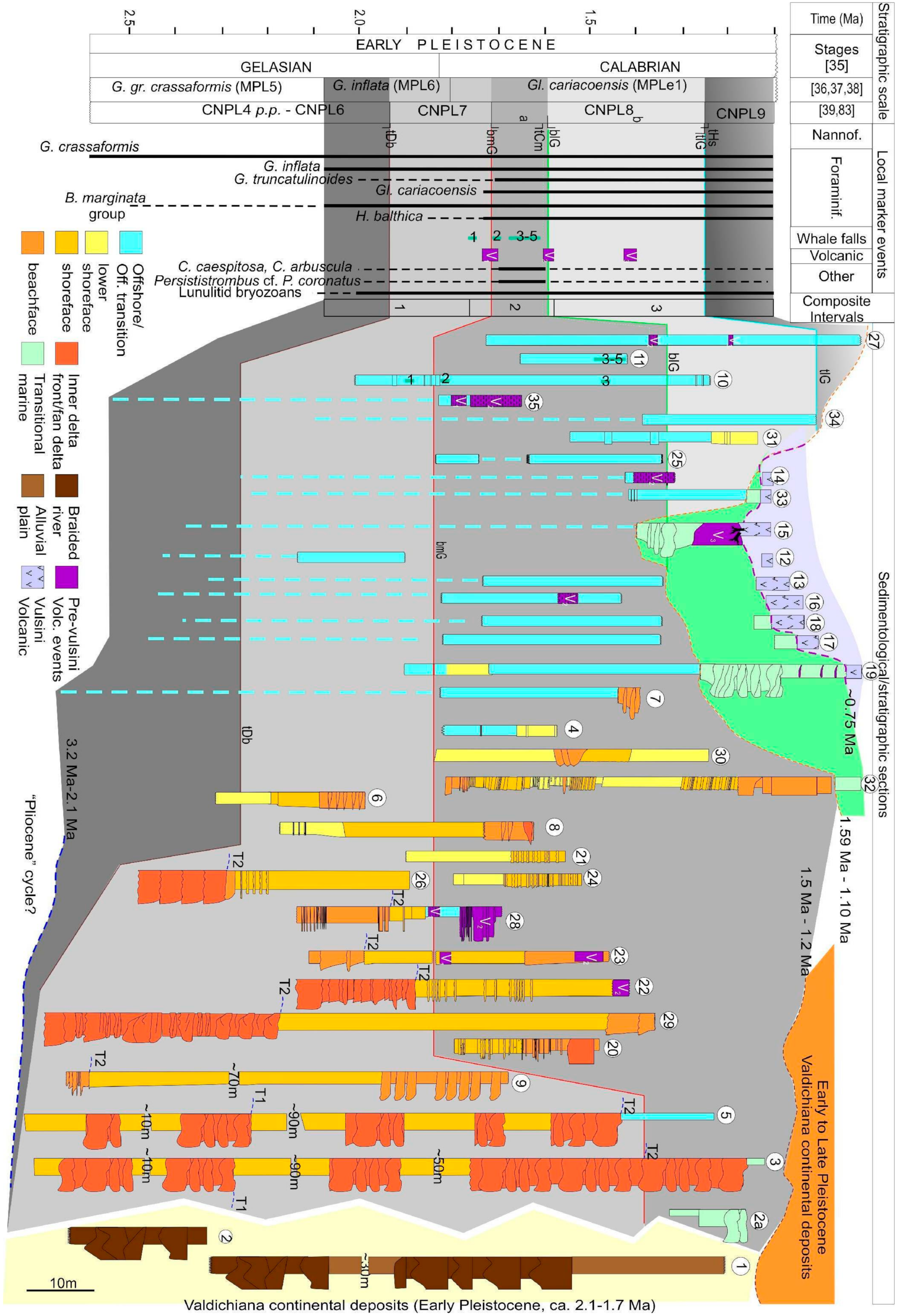
2.1.4. Benthic Foraminifers

Pliocene and Pleistocene biostratigraphic zonations by means of benthic foraminifers have been proposed for the Mediterranean [31,36,79,80]. In fact, the applicability of such schemes needs to be discussed. The only relevant stratigraphic datum for the study area is the common presence, often from the base of the sections, of the Hyalinea balthica and Bulimina marginata groups (Figure 6). All schemes agree in considering the first occurrence of these species inside the early Pleistocene.
As done for molluscs, two points causing biases in the past need to be reassessed.
  • The “Hyalinea balthica event”—The benthonic species Hyalinea balthica was commonly considered a Pleistocene proxy, its FAD marking the Santernian–Emilian boundary (i.e., 1.48 Ma [81]). In the Adriatic side of Italy, it has been documented at the top of the CNPL7 zone in the Arda river section [82]. In the study area, the first local datum for H. balthica falls inside the MNN19b zone (CNPL8, 1.75 Ma [17]), at the base of the Calabrian. As the stratigraphic meaning of this species needs to be reconsidered, these data highlight the importance of Hyalinea as a sea-floor paleotemperature proxy.
  • The “Amphistegina horizons”—Inside the “Pliocene” deposits, the former authors attributed a lithogenetic and stratigraphic meaning to a level enriched in Amphistegina sp., which has been considered a typical Pliocene bioevent and a marker bed for the Tyrrhenian side of Italy. [24,25,42,83]. In fact, several Amphistegina-rich levels occur [52], and in a wide stratigraphic range, thus avoiding any stratigraphic speculation. Several Amphistegina horizons, indeed, formerly attributed to the Pliocene, have revealed an early Pleistocene age [52]. Nonetheless, the paleoecological meaning of Amphistegina is clear, as this taxon always occurs in a shallow marine context, mainly referable to shoreface environments, both in rocky and fluvial-influenced coasts, while it lacks in deeper, colder environments [20]. At present, it seems difficult to correlate the fluctuations of the Amphistegina distribution to global rather than local paleoenvironmental changes, at least in the study area. These horizons are frequently weak- to hardly cemented by calcium carbonate, thus inducing to propose the interpretation of “beach rock-like deposits” [25]. This terminology is misleading, as present day beach rocks form in different sedimentological conditions [16]. More generally, the occurrence of biocalcarenites in northern Apennine during the Pliocene and Pleistocene reflects a wider problem, also involving the distribution of bioconstructions [74], early or late diagenesis [16,52], sequence stratigraphy, and climate [84]. Thus, Amphistegina-rich levels only provide an ecological signal, and their occurrences are only related to local paleoenvironmental conditions, but they are not age-dependent.
As pointed out [20], benthic foraminifers are mainly paleoecological/paleoenvironmental rather than biostratigraphic proxies, as their presence in the fossil record may depend on several factors, including depth, water temperature, and chemistry, grain size of sediments on the sea floor, fluvial input, vegetation, etc. As assemblages are extremely variable, benthic foraminifers in the area distribute among four main paleoecological assemblages:
  • Shallow water, relatively warm assemblages (infra- to circalittoral [20]), with a prevalence of Elphidium, Lenticulina, Ammonia, and Amphistegina;
  • Deeper water, relatively cool assemblages (bathyal), with a prevalence of Bolivina, Bulimina, and Uvigerina groups, accompanied by Planulina ariminensis and H. balthica [17,20];
  • Shallow water, with freshwater supply assemblages, showing a prevalence of Ammonia spp. and Quinqueloculina spp. [15,20,45];
  • Whale-fall related assemblages [54], dominated by Bigenerina nodosaria, Bannerella gibbosa, Marginulinopsis costata, and Vaginulina striatissima, with subordinate Lenticulina calcar and Siphotextularia concava.

2.1.5. Bryozoans

Bryozoan fragments are commonly reported from the study sections, particularly from sandy nearshore deposits (beachface, shoreface) [14,15,16,17,18,19,20], being part of the skeletal detritus (bioclastic lags). Furthermore, the occurrence of cupuladrid bryozoan assemblages has been alsodocumented [20].
Six different species belonging to the genera Reussirella, Cupuladria and Discoporella have been found, mainly in infra- to circalittoral, bioclastic-rich sand to silty sand deposits, which are referable to a moderate to low energy vegetated sea-floor. The grain size analyses, as well as the associationsof benthic foraminifers and molluscs, place them in a −10 to −60 m bathymetric range, with a prevalence between the −10 and −50 m interval. Lunulitiform growth also indicates warm to temperate water, high sedimentation rate, and a long-lasting transgressive trend for sea level [20].
As the presence of these bryozoans is not commonly documented in early Pleistocene deposits, and because they cover the whole stratigraphic range of thestudy deposits, this can be considered as a bio-event for the study area.

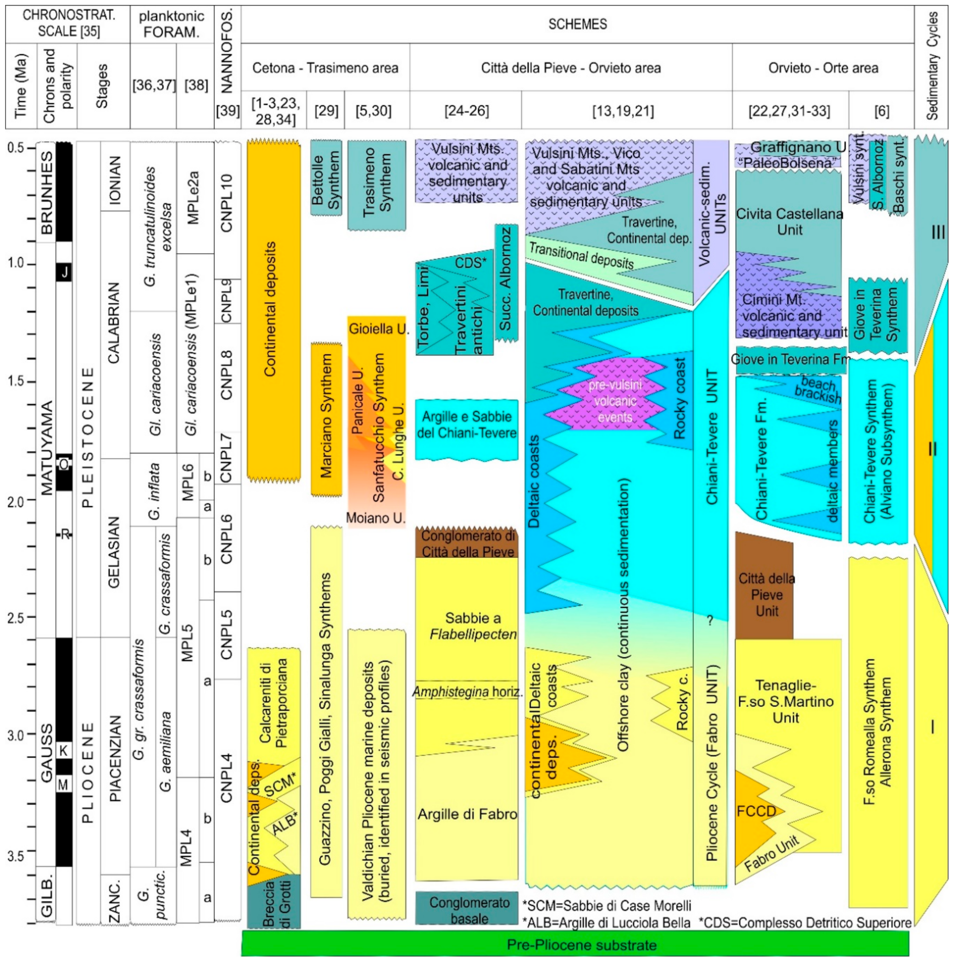
2.2. IntegratedStratigraphy

During the last two decades, one hundred sites have been described among outcrops, stratigraphic and sedimentological sections, borehole cores, and composite sections (Figure 2). Thirty-six stratigraphic sections (Figure 6) are here reported as the more significative in order to reconstruct an integrated stratigraphic scenario for the early Pleistocene in the Valdichiana Basin. Choosed marker events encompass biological, physical, and paleocological events.

2.2.1. Planktonic Foraminifers

In fact, the abundances of planktonic species are never particularly high, and assemblages are dominated by benthic forms. Moreover, several taxa hold a very long timedistribution, and they are of no utility for biozonation. Thus, a biostratigraphy only based on foraminifers is not very effective in the area.
The “Pliocene cycle” [24,25] was assigned to the Globorotalia puncticulataGloborotalia ex gr. crassaformis zones [36] (MPL4a p.p.–MPL5b zones [37,38]).
Recent revisions never noticed the occurrence of old forms of Globorotalia (such as G. margaritae or G. puncticulata); otherwise, the presence of G. ex gr. crassaformis is often accompanied by younger taxa, such as Globorotalia inflata and Globigerina cariacoensis [17,20].
The phyletic lineage also assuming stratigraphic significance is G. margaritaeG. puncticulataG. inflata, while the FO of G. crassaformis is diachronous in the Mediterranean area, and the stratigraphic use of this event is disputable [85,86]. Furthermore, the “crassaformis Group” includes several species/subspecies, covering a large time range [38].
Marine deposits are attributed tothe interval G. inflataGl. cariacoensis p.p. zones [36,37] (MPL6-MPLe1 p.p. zones [38]): we prefer to use here this wide biozonal attribution, although the first local datum for both taxa has beenlocally recognized [17]. Where one or both of these two markers are lacking, the presence of G. crassaformis itself is not age-indicative.

2.2.2. Calcareous Nannofossils

A clay–sand transition at the base of the Città della Pieve Hill comprising an assemblage of Discoaster gr. broweri, Discoaster surculus, Discoaster pentaradiatus, Discoaster variabilis, and Ceratolithus rugosus was firstly reported [24] and attributed to the NN 16 zone [87] (i.e.: MNN 16b–17 [88]). Nonetheless, the application of nannofossil stratigraphy in this area developed only recently [14,15,16,17,18,19,20,21]. For the Mediterranean area at least, several works demonstrate the applicability of nannofossilstratigraphic schemes, derived from deep-sea wells, to onland sections [17,89]. Particularly, the succession of events recognized herein (Figure 6) is the same with thoseproposed for the western Mediterranean [78,87,88,89,90].
In late Pliocene–early Pleistocene nannofossil stratigraphy, the dimensional range of the gephyrocapsids is now commonly considered as discriminant [39,86,88,90,91,92]. This evolutionary trend is a global signal in the Mediterranean, and it is strictly related to a progressive climatic deterioration and to a relative decrease of seawater temperature through the early Pleistocene [87,89,93,94].
Calcareous nannofossils distribution in the study area follows the same trend, which is commonly characterized by the occurrence of Gephyrocapsa spp., Reticulofenestra spp., Calcidiscus spp., and Coccolithus pelagicus [17].Assemblages outline the presence of three main stratigraphic intervals:
  • CNPL6 p.p.–CNPL7 [39]—Poor assemblages dominated by small Gephyrocapsa spp. (i.e., specimens <4μm [92]), accompanied by very rare and broken discoasterids (mainly Discoaster broweri) and Coccolithus pelagicus, characterizing the older deposits dated with sufficient reliability. The upper limit is marked by the bmG event [39,92], which was commonly recognized in the area. On the other hand, the base is not clearly identifiable. Small-sized gephyrocapsids appeared at the end of the late Pliocene [82,88], contemporaneously to the progressive disappearance of discoasterids. Unfortunately, only one section in the study area records a stratigraphic event (the LO of Discoaster broweri). Nonetheless, most deposits are successive to the FO of G. inflata, and this event can be placedwithin the CNPL6 zone [39] or in the upper part of the MNN 18 zone [88]. Thus, the interval extends between 2.1 and 1.7 Ma, and it corresponds to the CNPL6 p.p.–CNPL7 zones [39] or to the MNN 18 p.p.–MNN 19a zones [88].
  • CNPL8 [39]—Richer associations are commonly dominated by medium Gephyrocapsa spp. (4 μm ≤ ϕ < 6 μm [92]) and small Gephyrocapsa spp., Helicosphaera sellii, H. carteri, and Coccolithus pelagicus. In part of the assemblages, the occurrence of large Gephyrocapsa spp. (ϕ ≥ 6 μm [89]) was also noted. Another event, the tCm, which is age-comparable with the blG (1.619 and 1.59 Ma, respectively [39,88,92]), has been also locally documented [17]. The interval covers the whole extension of the CNPL8 zone [39]. In older schemes, the tCm and the blG events marked the limit of MNN 19b and MNN 19c subzones [88,92]. In the study area, both events can be useful to divide the CNPL8 zone in two parts, as indicated as CNPL8a and 8b, respectively (Figure 5). This local zonation also reflects the distribution of physical events (see Section 3.2).
  • CNPL9 p.p. [39]—Rarely, assemblages with only small Gephyrocapsa spp. and H. sellii, successive to the tlG event, were described [13,17]. Due to the lack of medium-sized Gephyrocapsa spp., they can refer to an interval between the tlG and the Tabs G = 4 μm events (very basal part of CNPL9, before the disappearance of H. sellii).

2.2.3. Volcanic Events

Within the deposits of the Chiani–Tevere unit, the occurrence of distal pyroclastic fallout material, mainly represented by leucite-bearing pumice and idiomorphic pyroxenes, has been documented [13,14,17,20,51,56,57]. These volcanic events (Figure 6) allow distinguishing between the two distinct sedimentary phases. During the first (V1 in Figure 6), at about1.8–1.75 Ma, volcanic events have not been documented so far in the sedimentary record. During the second phase (V2 and V3 in Figure 6), the presence of distal pyroclastic products, attributable to the Roman Comagmatic province, in several sections document an incipient volcanic Vulsini activity already in the early Pleistocene [13,51,56,57]. Biostratigraphic analyses allow assigning an age between 1.75 and 1.2 Ma to this second phase. These volcanic events, interspersed with sediments, are not present everywhere. Therefore, a local origin has been hypothesized, and a small eruptive center has not been yet identified, but it is probably located near Orvieto [56,57]. This ancient volcanic activity precedes the first Vulsini manifestations by approximately 700,000 years (volcanic event of the “PalaeoBolsena”) and is defined herein as “pre-Vulsini volcanic events” (Figure 3 and Figure 6).

2.2.4. Whale-Fall Events

The presence of cetaceans in the Paleo-Tyrrhenian Sea during the Pliocene and Pleistocene is well established [54,94], although few or less is known about their occurrence in the Valdichiana Basin. Recently, at least five relatively shallow water whale-fall events, still under analysis, were documented, particularly in southwestern Umbria. The Allerona area (section 10 and section 11 in Figure 2 and Figure 6) is the keypoint, due to the finding of whale skeletons, and the unique report of Ambergrisichnus alleronae as a particular type of evisceralites that have never been described before worldwide and were interpreted as being derived from fossil ambergris masses [49,50]. During theearly Pleistocene, this area truly was a “Cetacean Gulf”, where several individuals of baleens and spermwhales lived and died. The age of these events has beencalibrated between 1.8–1.75 and 1.59 Ma by means of calcareous nannofossils and planktonic foraminifers [50].
Several hypotheses were made to explain the occurrence of such mass-stranding events, which were concentrated in a relative short time interval: at the moment, the poisoning of water as a consequence of carbon dioxide emissions from the seabed seems reliable. Indeed, a time overlapping can be noted between volcanic and whale-fall events (Figure 6), particularly with the V2 volcanic event at about 1.75 Ma. Moreover, several structures, preserved on the paleo-sea bottom and preliminarily interpreted as probable carbonate conduits, were recently found in a neighboring area: studies are still in progress, but preliminary results look promising (Boschi C., personal communication).

2.3. Evidence of Cycles Stratigraphy

Regressive and transgressive trends were documented throughout nearshore deposits, regardless of environmental context, presumably marking fourth- to fifth-order cycles [14,15,16,17,18,19,20,21].
On the other hand, offshore clays record continuous variations in grain size distribution (i.e., a higher or lower sandy/silty fraction), and the occurrence of the same trends is more uncertain (Figure 5). The occurrence of at least two moments of relative shallower depth, at the base of the CNPL8 and CNPL9 zones, respectively, was proposed [20].
Throughout the basin, deposits clearly mark the occurrence of two main transgressive–regressive trends, in the CNPL6, p.p.-CNPL7, and CNPL8a–8b zones, respectively, presumably covering the time interval between ≈2.2 and 1.59 Ma. As if some more uncertainty arises at the beginning of the older one, the younger transgressive phase can be confidently positioned at about 1.71–1.75 Ma (i.e., across the CNPL7–CNPL8 zone limit). Contrarily to transgressive phases, the position of regressive phases is more uncertain [20], inside the CNPL6 p.p.-CNPL7, CNPL8a, and CNPL8a–8b zones (Figure 6).
Thus, these general trends may reflect astronomic cyclicity, particularly eccentricity (100–410 ky), being interpreted as high-frequency sea-level fluctuations, or they may result from changes in local conditions (tectonics).
Inside this general scheme, a shorter-scale cyclicity has been also documented [15,16], particularly in delta front and rocky coast deposits.

2.3.1. Delta Front

By means of facies associations, shallow marine deposits described in the northeastern part of the basin (Figure 2) have been referred to a shallow-water, stable and long-lasting delta environment [15]. Gravel/sand alternations and clinostratified sands represent mouth bar deposits (inner delta front) and sand macroforms (outer delta front), respectively [15]. Deposit organization, as well as the characteristics of the feeding fluvial system (Figure 5a), lead to a discontinuous sediment supply due to an irregular river discharge, reflex of climatic changes, tectonics, eustacy, exceptional flooding, rainy period, etc. During the CNPL6 p.p.–CNPL7 interval, the deltaic system mainly tends to aggradate and then to progradate, and a second main transgressive phase approximates the bmG event (Figure 6). Between the two successive periods of intense fluvial activity, several minor relative sea-level oscillations upon a conservative coastal system were recorded, and both proximal and distal front deposits show an alternation of regressive (progradation) and transgressive (starvation) phases of the delta system. This high-frequency cyclicity can be described in terms of fifth- or sixth-order sea-level fluctuations, associated with an alternate prevalence of alluvialand marineprocesses.During a phase of limited river activity, the inner delta front is occupied by submerged beaches in a shoreface context, wave and current processes dominate, and reworking takes place, with deposits recording a relative sea-level rise. During this phase, storms characterize the lower shoreface and promote the development of erosion surfaces, which is colonized by large pectinids and burrowing crustaceans toward the end of the relative rise. Sandy sediment removed onthe lower shoreface is organized as dunes and ripples on upper shoreface environments, and a broad landward sediment transport occurs in the outer delta front. This on-shore sedimentation is probably accompanied by a contemporaneous offshore sedimentation of silt and clay. When the river sediment supply permits coastal system progradation (paroxystic events), both gravel cross-stratified mouth bars and external delta front sand waves form, with the flow evolution mechanism earlier described. The delta front progradation is recorded as a relative sea-level fall.

2.3.2. Rocky Coast

Rocky-coast sections (Figure 5c; section 30 to section 32 in Figure 6) mark a main transgressive trend inside the CPL8a interval (between ≈1.71 and ≈1.59 Ma): the lowermost transgression above the rocky substratum can be found at about 270 m a.s.l., whereas the uppermost cliff-toe deposits are 100–150 m higher, showing a general trend of the cliff’s retreat. The composite sections resume the occurrence of five transgressive–regressive cycles [16], and the occurrence of lower, older cycles cannot be excluded. This short-term alternation of transgressive and regressive phases has been interpreted in terms of 5th-order cycles [16], which is probably due to local variations on relative sealevel that is probably driven by the interaction betweenthe cliff’s erosion and local subsidence rates.

2.4. Climate

The key principium guiding most of the former stratigraphic schemes was the high relevance attributed to glacial–interglacial stages and to their correspondence with “erosional” (regressive) and transgressive phases, both on marine and continental deposits. Basedon this climate-driven idea, boundaries between main sedimentary cycles matched with main erosional phases, usually named “Acquatraversa” (≈2.2–1.8 Ma), “Aulla” (≈1.6–1.4 Ma), and “Cassio” (≈1.2–1.1 Ma) [22,24,25,81].
In fact, the consequences of climatic change in southern Europe betweenthe late Pliocene and early Pleistocene are only partly comparable with the main situation of the northern hemisphere [7,21], and a latitudinal effect has been noted [95]. Still, during the lower early Pleistocene, central Italy was a refuge for several floral and faunal taxa that were able to tolerate a relative cooling in air and water temperatures [21]. Even approximating the early–middle Pleistocene boundary, the deterioration of the climate mainly shifts toward dry/arid rather than cold conditions [7,95]. Consequently, still inside a general coolingtrend, the main effects on marine water temperature depend on the bathymetry, deep water being cool (but never really cold), while shallow water still allowing the life cycle of relatively warm benthic taxa [19,20,21].
Astronomically forced climatic changes should act in some way and should be considered (see Section 2.3); a relation between sedimentation and Milankovitch cycles is reliable, both considering the general transgressive–regressive trends and the high frequency cyclicity. Nonetheless, both the basin evolution and the paleoenvironmental complexity depend on several interacting causes, such as tectonics, sedimentation, inherited morphologies, etc., in a general context of climatic deterioration. Thus, the climate signal was superimposed on this general scenario, but it was not the unique factor.

2.5. Tectonics

As for the whole history of the Neogene–Quaternary northern Apennine basins, any speculation on the paleogeographic evolution of the Valdichiana Basin cannot ignore the role of tectonics and the interaction with sedimentation [5,30,44].The basin is bounded by extensional faults [4,5,6,96], and the role of tectonics in its setup is undoubted. Nonetheless, the age is uncertain, although an early Pliocene or even Messinian origin is realistic. If strips of older (Pliocene) deposits really crop out westwards and are the same as those now widely buried under the continental unitson the Trasimeno area [5], the first evolutionary phase should be related to aneastwards-dipping master faults system on the western basin’s flank [40,96]. The development of continental environment northwards, feeding a braided delta apparatus, and the southward shift of deltaic deposits suggests the depocenter migration and the activity of this fault throughout the lower early Pleistocene [44]. The Trasimeno Basin development, as well as the actual NE dip of both Città della Pieve deltaic deposits and Valdichiana continental deposits, is a consequence of the NE tectonic inclination of the area that probably begins during the upper early Pleistocene, and which continues through the early–middle Pleistocene boundary. This regional tectonic phase was driven by fault systems on the eastern margin, dipping westwards, and it presumably continued to recent times. Southwards, it was probably responsible, at different times, for the dislocation of blocks of the Narnese–Amerina Range with deposits that had different elevation, the progressive marine retreat southwestwards, and finally the deviation of the Tiber River, excavating a deep canyon through the mountain chain (Figure 2).

3. Proposed Stratigraphic Scheme for Western Umbria

All the data presented here take place in a comprehensive, composite, and integrated stratigraphic scheme (Figure 6 and Figure 7). The geological implications are discussed for both local and regional reconstruction.
More or less, the totality of deposits cropping out in the area, or accessible through shallow boreholes, are Pleistocene rather than Pliocene in age. Furthermore, with rare exceptions, deposits are no older than the uppermost Gelasian.
In our opinion, the wide recognition of Piacenzian (and even Zanclean) deposits made by previous authors [6,24,25] arises from various causes.
Although we recognize the scientific value of pioneering works, which proposed a brand new local stratigraphic scheme [24,25], we think they lack reliable biostratigraphic tools, such as nannofossil biostratigraphy. Moreover, the role of benthic faunas as stratigraphic tools has been overestimated, while their role as paleoecological indicators has been little or not considered at all.
Asseveral criticisms were pointed out, and as they emerged also in other case studies [45,70,71,97], a critical review of data would be expected.

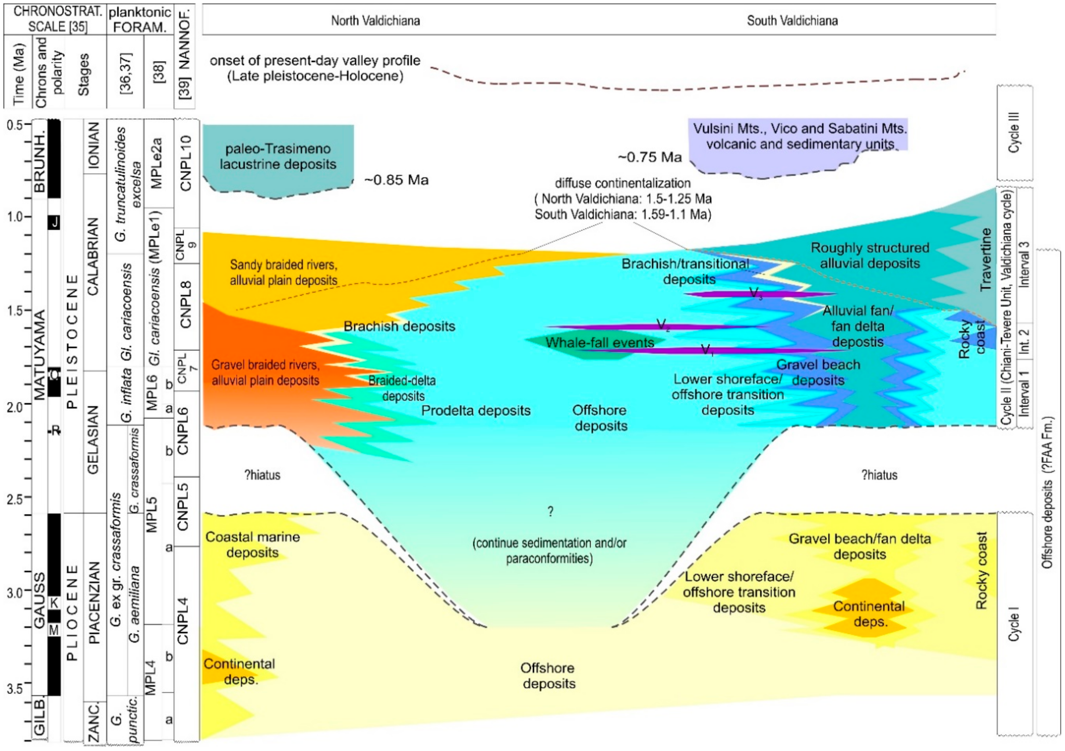
3.1. The Pliocene Cycle

As generally supposed for the Mediterranean region, previous paleogeographic reconstructions proposed the emergence of wide areas during the Messinian, which were followed by a marine transgression at the Miocene–Pliocene boundary [31,42]. Transgression was probably extremely rapid, thus obliterating most of the continental/coastal deposits, which were suddenly replaced by deep sea sediments, as recently documented for southern Italy [98]. Seismic profiles in the northern area [5,96] clearly reveal a buried unit, unconformably lying on the substrate (disconformity/angular unconformity), which presumably records the onset of marine conditions in the area. Thus, the occurrence of a “Pliocene cycle” should be expected.
In fact, none of the sections studied through the last years clearly document Pliocene deposits belonging to Cycle I. When reconsidered, and in the light of biostratigraphy, proximal deposits were early Pleistocene rather than late Pliocene in age. The macrofossil record does not allow discrimination, and it has no stratigraphic relevance, while microfossils clearly denote Pleistocene characters. This is an open problem, and some hypotheses can be proposed. If the area was affected by a marine ingression only starting from the early Pleistocene, the Pliocene cycle simply does not exist. At the moment, this hypothesis looks unlikely. The occurrence of Piacenzian shallow marine depositsisstill not totally excluded, but they werecertainly less widespread than previously supposed, and they were probably mainly confined in the northern sector [23,28,29]. This looks reliable at least for transitional to continental Pliocene deposits, whose occurrence was spotted and only limited to restricted areas [31,32,33,34]. This lack can be also explained in terms of a wide reworking of deposits during the successive, early Pleistocene cycle. In any case, the consequence is that the occurrence of a Pliocene coastal marine to continental evolution in the area is reasonable but not verifiable, at least not in the light of the present data.
A different discussion is needed for offshore deposits. The thickness of these mainly clayey deposits locally reaches several hundred meters, and only a small portion is easily accessible and has been theobject of a detailed stratigraphy. Thus, the occurrence of Pliocene should be expected. In neighbouring basins, clay deposits seem to record a steady, although often discontinuous, offshore sedimentation from the Zanclean to the Piacenzian, or more feasibly, to the Calabrian [8,9,10,11,12,45,70,71,89]: the top of the deposits, indeed, records a similar situation such as the one described for Valdichiana.
Open marine/offshore clay deposits should record the same cycles and events as coastal/continental deposits, but they may not be recognizable.
A possible solution can be the use of FAA Fm. for Pliocene–Pleistocene offshore clay deposits through the whole Italian peninsula, with some general caution:
  • It should be limited to distal marine deposits (i.e., offshore clay), avoiding including all other facies associations, often indicating shallower/proximal paleoenvironments;
  • The continuity in sedimentation was probably only seeming, and paraconformities could be expected;
  • The age of deposits is highly variable, between different basins and/or different portions of the same basin, and the simple look of massive to slightly laminated blue clay is not age-indicative;
  • Each basin, in its proximal parts at least, evolved independently from the neighboring ones.
For all the aforementioned reasons, the use of historical local unit names is anachronistic and often misleading, and it should be abandoned or limited. We propose the use of “Cycle I” for the (Zanclean) Piacenzian hypothetic evolution of coastal areas, and “Offhore deposits” to indicate the continuous (or paraconformable) distal marine sedimentation.

3.2. The Chiani–Tevere Cycle (Early Pleistocene)

During a long-lasting phase (Gelasian to the uppermost Calabrian), the area encompasses the higher paleoenvironmental variability [13,14,15,16,17,18,19,20,49]. Deposits of marine, transitional, and continental environments are recognizable, with a significant facies heterotopy. This paleoenvironmental variability belongs to a unique informal lithostratigraphic unit, the “Chiani–Tevere unit” (Figure 2), according to the recent proposed schemes [19,20,21]. Although the use of Cycle II would be preferable, this name for the unit can be maintained, as it accommodates the higher documentable lateral facies heterotopy and paleoenvironmental complexity [13,14,15,16,17,18,19,20,21,22]. Otherwise, the name “Valdichiana cycle” could be proposed. These paleoenvironments vary from more or less structured alluvial plain, deltas, river-fed beaches, rocky coasts, shallow marine (shoreface to offshore transition), and open marine. The sea (Paleo-Tyrrhenian Sea), near the coast, should not have reached depths greater than 120–150 m [20,50].
In marine and transitional deposits (Figure 6), associations of foraminifers and calcareous nannofossils allow identifying an age range that extends, seamlessly, from about 2.2 to about 1.2 Ma (Calcareous nannofossils Biozones CNPL6 p.p.–CNPL9 p.p.; Globorotalia inflata–Globigerina cariacoensis zone [17]). This time range is also confirmed for continental deposits [13,14,15,21,44,51], which can be attributed to late Villafranchian Faunal units (2.2–1.2 Ma).
The whole interval of the Chiani–Tevere unit can be divided in three subsequent steps (Figure 6 and Figure 7) by means of integrated stratigraphy and documented events.

3.2.1. Interval 1 (Gelasian p.p.–Calabrian p.p.)

This interval covers a time range between ≈2.1 and≈1.75 Ma (CNPL6 p.p.–CNPL7 zones; G. inflata–G. cariacoensis p.p. zones). The base can be positioned at the FO of G. inflata, as older deposits were not documented, although they can reasonably exist in the area. The top roughly anticipates the bmG event (Figure 6) and corresponds to the base of the pre-Vulsini volcanic event. In this interval, marine and continental deposits lack thevolcanic materials.
The planktonic record is characterized by the presence of G. inflata, the co-occurrence of G.ex gr. crassaformis, and Gephyrocapsa spp. between 3 and 4 μm. Although it is not used to further internal subdivisions, the tDb event (LO of D. broweri) occurs in this interval, and it allows better calibrating the base of this interval and of the Chiani-Tevere unit itself.
With minor exceptions (section 6 and section 8 in Figure 6), coastal systems (both deltaic and river-fed beaches) record a diffuse transgressive phase, which is followed by regression. A new transgression occurred atabout the limit of Interval 2 (Figure 6).

3.2.2. Interval 2 (Calabrian p.p.)

This phase begins at about 1.75 Ma (bmG event) and extends to about 1.59 Ma: as the top approximately matches the blG, this event takes a relevant stratigraphic meaning for the study area. Locally, the tCm event (LO of C. macintyrei: 1.619 Ma) also occurs: as it is close tothe blG event, it better calibrates the age of deposits, near the top of the interval.
Marine and continental deposits record the main phases of “pre-Vulsini volcanic events” (V1 and V2 in Figure 5), as well as the whale-fall events 2 to 5 (Figure 6).
In the micropaleontological record, Gl. cariacoensis, G. truncatulinoides, H. balthica, and Gephyrocapsa spp. >4 μm add to species still occurring in Interval 1.
As said, the transgressive–regressive trend continues through this interval; both northwards and southwards, the transgressive phase at about 1.75 Ma was the last marine ingression in the area, which then underwent progressive and diffused emersion during Interval 3 (Figure 6 and Figure 7).

3.2.3. Interval 3—The Late Early Pleistocene Transitional Phase

Marine deposits attributable to the Chiani–Tevere Cycle continue up to about 1.2 Ma, but they are only documented in restricted areas [13]. The top of clay sediments assumes different ages in the outcrops (Figure 6); furthermore, clay deposits with the same age are now displaced at different altitudes, which is due to recent tectonics. Locally, interposed between clay and volcanic vulsine materials, continental and/or transitional deposits occur. Evidence indicates a progressive withdrawal of the sea, starting from the early Pleistocene, and the shift toward transitional and then fluvial–lacustrine environmental conditions. This environment is documented by mixed sedimentary and volcanic deposits, which can be well described in the Orvieto section (section 15 in Figure 6). Under the Orvieto cliff, these deposits have, at least in the initial portion, an age comparable with that of marine clays at the top of the Chiani-Tevere unit, and they document the passage from a full marine to a continental environment, with the setting of river tracks between marshy areas.
Although the beginning of the Vulsini volcanic activity is commonly placed at about 590,000 years ago, the volcanic material present in these mixed sedimentary and volcanic deposits probably represents an intermediate phase that is still datable to the early Pleistocene, or it can even be compared with the final phase of pre-Vulsini volcanic events (Figure 6 and Figure 7). Pyroclastic deposits were separated by time intervals, during which the evolution of the continental landscape continued, as evidenced by the presence of trees [13] (the so named “cave of fossil trunks”, on the Orvieto hill), which sank their roots on a soil produced by the decay of volcanic material and were subsequently burned, partially demolished, and buried by a new pyroclastic event.
The same continentalization involved other southern parts of the basin (sections 12–14, sections 16–19, section 33 in Figure 6), with theoccurrence of travertine: particularly on the flank of the Narnese-Amerina Range, they were dated to 1.7–1.4 Ma due to the presence of vertebrate remains [22,25,44].
A similar diffuse emersion occurred northwards: the deltaic environment was progressively abandoned, firstly as a consequence of marine transgression, then with a possible inversion of river drainage northwestwards [44]; then, a structured alluvial plain environment developed, and a tidal-influenced coast probably characterized the northwestern sector [45].
This transitional phase started between 1.59 and 1.25 Ma, and it proceeded until about the early–middle Pleistocene boundary; in the proposed scheme, it is considered as part of the evolution of the Chiani-Tevere unit.

3.3. The Middle to Late Pleistocene Evolution

While they are found northwards, they are cut by the lacustrine deposits of Paleo-Trasimeno, southwestward marine, and/or continental deposits of the Chiani–Tevere cycle, which constitute almost everywhere the substrate of the Vulsini Mts., Vico, and Sabatini Mts. volcanic and sedimentary units (middle Pleistocene). Particularly, the most diffused one is the Ignimbrite of Orvieto–Bagnoregio (about 294,000 years ago [99,100]). The demarcation surface shows an irregular pattern, which was probably inherited from an ancient phase of land modeling [101], to which is added albeit a minimal tectonic activity. On the left side of thePagliaRiver, close to the reliefs of M. Peglia, the same marine and continental units emerge, but without the overlying volcanic manifestations, and this has been interpreted as probably due to an incipient activity of the border fault along the eastern slope of the Paglia Valley [40].
The effects of tectonics are even more clear northwards in the present day Trasimeno area. Tectonic activity started approximately at the early–middle Pleistocene boundary, and it was responsible for the northeast tilting of sedimentary units, with the formation and development of the Trasimeno Lake itself [5,30].

4. Conclusions and Next Steps

From the Pliocene to the Quaternary, the time and the order of succession of several planktonic bioevents is the same in the whole western Mediterranean. Thus, the biostratigraphic correlation between the deep-sea drillings and on-land sections, and between different basins in different geographic positions, can be applied. On the other hand, each basin holds its peculiar geological evolution, although following the same general evolutionary trend. The record of other events (volcanic events, whale-fall events), as well as the tectonic phases, should be considered under this light, as they may (or may not) represent regional events.
Although its history began earlier, the Valdichiana Basin underwent marine conditions relatively later, in respect to other basins in the Northern Apennine, and the main part of its evolution and paleoenvironmental complexity can be considered as early Pleistocene in age.
This basin evolved independently from neighbouring basins, although all of them can be reasonably considered related to the wide open marine environment belonging to the FAA Fm.
This early Pleistocene stratigraphic, sedimentological, and paleoenvironmental scheme looks now sufficiently delineated; nonetheless, some ongoing problems still remain.
Further investigations should reconstruct the complete stratigraphy of offshore clay deposits, which were investigated only in their easily accessible parts, possibly integrating borehole and seismic data that are lacking at the moment. Investigations should also be focused on the margins of the basin to clarify its relations with the closest basins (particularly with the continental/marine Radicofani–Siena Basin, and with the continental Tiberino Basin: Figure 2), and to better define its evolution southwards, toward the open sea (Paleo-Tyrrhenian Sea).

Funding

This research received no external funding.

Acknowledgments

We are grateful to the two anonymous reviewers for the punctual revision of the manuscript. Authors also wish to thank all the graduate students, which contributed to research projects through the last 20 years.

Conflicts of Interest

The authors declare no conflict of interest.

References

  1. Jacobacci, A.; Martelli, G.; Nappi, G. Note Illustrative della Carta Geologica d’Italia alla Scala 1,100000Foglio 129 "Santa Fiora"; Servizio Geologico d’Italia: Roma, Italy, 1967; pp. 1–61. [Google Scholar]
  2. Jacobacci, A.; Malatesta, A.; Martelli, G. Note Illustrative della Carta Geologica d’Italia alla Scala 1,100000 Foglio 121 "Montepulciano"; Servizio Geologico d’Italia: Roma, Italy, 1969; pp. 1–73. [Google Scholar]
  3. Jacobacci, A.; Bergomi, C.; Centamore, E.; Malatesta, A.; Malferrari, N.; Martelli, G.; Pannuzzi, L.; Zattini, N. Note Illustrative della Carta Geologica d’Italia alla Scala 1,100000 Foglio 115 "Città di Castello", 122 "Perugia", 130 "Orvieto"; Servizio Geologico d’Italia: Roma, Italy, 1970; pp. 1–151. [Google Scholar]
  4. Martini, I.P.; Sagri, M. Tectono-sedimentary characteristics of late Miocene-Quaternary extensional basins of the North Apennines, Italy. Earth Sci. Rev. 1993, 34, 197–223. [Google Scholar] [CrossRef]
  5. Gasperini, L.; Barchi, M.R.; Bellucci, L.G.; Bortoluzzi, G.; Ligi, M.; Pauselli, C. Tectonostratigraphy of Lake Trasimeno (Italy) and the geological evolution of the Northern Apennines. Tectonophysics 2010, 492, 164–174. [Google Scholar] [CrossRef]
  6. Regione Umbria. Carta Geologica dell’Umbria. Available online: http://dati.umbria.it/dataset/carta-geologica-dell-umbria (accessed on 4 July 2020).
  7. Martinetto, E.; Bertini, A.; Basilici, G.; Baldanza, A.; Bizzarri, R.; Cherin, M.; Gentili, S.; Pontini, M.R. The plant record of the Dunarobba and Pietrafitta sites in the Plio-Pleistocene palaeoenvironmental context of central Italy. AMQ 2014, 27, 29–72. [Google Scholar]
  8. Conti, P.; Cornamusini, G.; Carmignani, L. An outline of the geology of the Northern Apennines (Italy), with geological map at 1:250,000 scale. Ital. J. Geosci. 2020, 139, 149–194. [Google Scholar] [CrossRef]
  9. ISPRA. Carta Geologica d’Italia 1:50.000. Catalogo delle Formazioni; I Quaderni serie III 2007, 7(VII), 318–330. Available online: https://www.isprambiente.gov.it/it/pubblicazioni/periodici-tecnici/i-quaderni-serie-iii-del-sgi/carta-geologica-ditalia-1-50-000-catalogo-delle-3 (accessed on 3 August 2020).
  10. Benvenuti, M.; Del Conte, S.; Scarselli, N.; Dominici, S. Hinterland basin development and infilling through tectonic and eustatic processes: Latest Messinian-Gelasian Valdelsa Basin, Northern Apennines, Italy. Basin Res. 2014, 26, 387–402. [Google Scholar] [CrossRef]
  11. Cello, G.; Coccioni, R.; Gazzani, D.; Nesci, O.; Pennacchioni, E.; Piccini, M.; Riccioni, M.; Sampaolesi, S.; Tondi, E.; Critelli, S.; et al. Note Illustrative della Carta Geologica d’Italia alla Scala 1:50.000-Foglio 303 “Macerata”; ISPRA: Roma, Italy, 2009; pp. 1–90. [Google Scholar]
  12. Cantalamessa, G.; Di Celma, C. Sequence response to syndepositional regional uplift: Insights from high-resolution sequence stratigraphy of late Early Pleistocene strata, Periadriatic Basin, central Italy. Sediment. Geol. 2004, 164, 283–309. [Google Scholar] [CrossRef]
  13. Baldanza, A.; Bertinelli, A.; Bizzarri, R.; Monaco, P.; Parisi, G. Lungo la costa del Mar Tirrenodue milioni di anni fa. In L’Ignimbrite di Orvieto-Bagnoregio; Peccerillo, A., Ed.; Edizioni Nuova Prhomos: Città di Castello, Italy, 2012; pp. 135–159. ISBN 978-88-97900-29-0. [Google Scholar]
  14. Bizzarri, R. Depositi Plio-Pleistocenici tra la Val di Chiana e il Lago di Corbara: Caratterizzazione Sedimentologica e Ricostruzione Paleoambientale. Ph.D. Thesis, University of Perugia, Perugia, Italy, 23 February 2007. [Google Scholar]
  15. Bizzarri, R.; Baldanza, A. Plio-Pleistocene deltaic deposits in the Città della Pieve area (western Umbria, central Italy), facies analysis and inferred relations with the South Chiana Valley fluvial deposits. Quaternario 2009, 22, 127–138. [Google Scholar]
  16. Bizzarri, R. Early Pleistocene rocky coasts (Orvieto area, western Umbria, central Italy), facies analysis and sedimentation models. Ital. J. Geosci. 2010, 129, 251–268. [Google Scholar] [CrossRef]
  17. Baldanza, A.; Bizzarri, R.; Hepach, H. New biostratigraphic data from the early Pleistocene Tyrrhenian paleocoast (western Umbria, central Italy). Geol. Croat. 2011, 64, 133–142. [Google Scholar] [CrossRef] [Green Version]
  18. Monaco, P.; Famiani, F.; Bizzarri, R.; Baldanza, A. First documentation of wood borings (Teredolites and insect larvae) in isolated clasts of early Pleistocene lower shoreface deposits (Orvieto area, central Italy). Boll. Soc.Paleont. It. 2011, 50, 55–63. [Google Scholar]
  19. Baldanza, A.; Bizzarri, R.; Famiani, F.; Pasini, G.; Garassino, A.; De Angeli, A. Early Pleistocene shallow marine decapod crustaceans fauna from Fabro Scalo (western Umbria, central Italy), taxonomic inferences and palaeoenvironmental reconstruction. Neues Jahrbuch Geol. Paläontologie 2014, 271, 261–283. [Google Scholar] [CrossRef]
  20. Bizzarri, R.; Rosso, A.; Famiani, F.; Baldanza, A. Lunulite bryozoans from early Pleistocene deposits of SW Umbria (Italy), sedimentological and paleoecological inferences. Facies 2015, 61, 420:1–420:20. [Google Scholar] [CrossRef]
  21. Martinetto, E.; Momohara, A.; Bizzarri, R.; Baldanza, A.; Delfino, M.; Esu, D.; Sardella, R. Late persistence and deterministic extinction of “humid thermophilous plant taxa of East Asian affinity” (HUTEA) in southern Europe. Palaeogeog. Palaeoclim. Palaeoecol. 2017, 46, 211–231. [Google Scholar] [CrossRef]
  22. Mancini, M.; Girotti, O.; Cavinato, G.P. Il Pliocene ed il Quaternario della Medie Valle del Tevere (Appennino Centrale). Geol. Rom. 2004, 37, 175–236. [Google Scholar]
  23. Passerini, F. Il Monte Cetona (Provincia di Siena). Boll. Soc. Geol. It. 1965, 83, 219–338. [Google Scholar]
  24. Ambrosetti, P.; Conti, M.A.; Parisi, G.; Kotsakis, T.; Nicosia, U. Neotettonica e cicli sedimentari plio-pleistocenici nei dintorni di Città della Pieve (Umbria). Boll. Soc. Geol. It. 1977, 96, 605–635. [Google Scholar]
  25. Ambrosetti, P.; Carboni, M.G.; Conti, M.A.; Esu, D.; Girotti, O.; La Monica, G.B.; Landini, B.; Parisi, G. ll Pliocene ed il Pleistocene inferiore del bacino del Fiume Tevere nell’Umbria meridionale. Geogr. Fis. Dinam. Quat. 1987, 10, 10–33. [Google Scholar]
  26. Pialli, G.; Martini, E.; Sabatini, P. Contributo alla conoscenza della geologia del colle di Orvieto. Boll. Soc. Geol. It. 1978, 97, 103–104. [Google Scholar]
  27. Girotti, O.; Mancini, M. Plio-Pleistocene stratigraphy and relations between marine and non—Marine successions in the middle valley of Tiber river (Latium, Umbria). Quaternario 2003, 16, 89–106. [Google Scholar]
  28. Costantini, A.; Dringoli, L. Geologia dell’area fra Chianciano Bagni e Sarteano (Provincia di Siena). Carta Geologica S.E.L.C.A.: Firenze, Italy, 2002. [Google Scholar]
  29. Aruta, G.; Borgia, A.; Bruni, P.; Cecchi, G.; Cipriani, N.; Tredici, Y. Pliocene and Pleistocene unconformity bounded stratigraphic units (UBSU) in Val di Chiana. In The "Regione Toscana" Project of Geological Mapping: Case Histories and Data Acquisition; Morini, D., Bruni, P., Eds.; Tipografia Martinelli: Bagno a Ripoli, FI, Italy, 2004; pp. 133–136. [Google Scholar]
  30. Argenti, P.; Bizzarri, R.; Pazzaglia, F. IV.5-Successioni dei Bacini sedimentari plio-pleistocenici. In Note Illustrative della Carta Geologica d’Italia alla Scala 1:50.000—Foglio 310 "Passignano sul Trasimeno"; Barchi, M., Marroni, M., Eds.; ISPRA: Roma, Italy, 2014; pp. 74–99. ISBN 978-88-9311-034-1. [Google Scholar]
  31. Barberi, F.; Buonasorte, G.; Cioni, R.; Fiordelisi, A.; Foresi, L.; Iaccarino, S.; Laurenzi, M.A.; Sbrana, A.; Vernia, L.; Villa, I.M. Plio-Pleistocene geological evolution of the geothermal area of Tuscany and Latium. Mem. Descr. Carta Geol. It. 1994, 49, 77–134. [Google Scholar]
  32. Ciangherotti, A.D.; Esu, D.; Girotti, O. Review of the history of the Late Neogene-Early Quaternary non-marine molluscs of Italy. Meded. Ned. Inst. Toegepaste Geowetensch. TNO 1998, 60, 491–498. [Google Scholar]
  33. Petronio, C.; Argenti, P.; Caloi, L.; Esu, D.; Girotti, O. Sardella, R. Updating villafranchian mollusc and mammal faunas of Umbria and Latium (Central Italy). Geol. Rom. 2002, 36, 369–387. [Google Scholar]
  34. Boscato, P.; Coltorti, M.; Reggiani, P. Pliocene Anancus arvernensis (Croizet & Jobert, 1828) remains from Cetona (Siena): Stratigraphy, chronology and paleoenvironment. Boll. Soc. Geol. It. 2008, 127, 151–162. [Google Scholar]
  35. Cohen, K.M.; Gibbard, P. Global chronostratigraphical correlation table for the last 2.7 million years v.2019 (Poster version). Mendeley Data 2020, 3. Available online: http://dx.doi.org/10.17632/dtsn3xn3n6.3#file-04115e03-ac94-49d7-bdca-1797ecfccac3 (accessed on 5 August 2020).
  36. Colalongo, M.L.; Sartoni, E. Schema biostratigrafico per il Pliocene ed il Pleistocene in Italia. In Contributi Preliminari alla Carta Neotettonica d’Italia; P.F. Geodinamica 251 CNR.; CNR: Roma, Italy, 1979; pp. 645–654. [Google Scholar]
  37. Cita, M.B.; Capraro, L.; Ciaranfi, N.; Di Stefano, E.; Marino, M.; Rio, D.; Sprovieri, R.; Vai, G.B. Calabrian and Ionian: A proposal for the definition of Mediterranean stages for the Lower and Middle Pleistocene. Episodes 2006, 29, 107–113. [Google Scholar] [CrossRef] [PubMed] [Green Version]
  38. Iaccarino, S.; Premoli Silva, I.; Biolzi, M.; Foresi, L.M.; Lirer, F.; Turco, E.; Petrizzo, M.R. Practical Manual of Neogene Planktonic Foraminifera. In Proceedinfs of the International School on Planktonic Foraminifera 6th Course, Perugia, Italy 19–23 February 2007; University of Perugia: Perugia, Italy, 2007; pp. 1–181. [Google Scholar]
  39. Backman, J.; Raffi, I.; Rio, D.; Fornaciari, E.; Pälike, H. Biozonation and biochronology of Miocene through Pleistocene calcareous nannofossils from low and middle latitudes. Newsl. Stratigr. 2012, 45, 221–244. [Google Scholar] [CrossRef]
  40. Cencetti, C.; Conversini, P.; Tacconi, P. The rock of Orvieto (Umbria, Central Italy). GGA 2005, 1, 103–112. [Google Scholar] [CrossRef]
  41. Fazzini, P. La geologia dei Monti d’Amelia (Tr). Mem. Soc. Geol. It. 1968, 7, 441–469. [Google Scholar]
  42. Ambrosetti, P.; Carboni, M.G.; Conti, M.A.; Costantini, A.; Esu, D.; Gandin, A.; Girotti, O.; Lazzarotto, A.; Mazzanti, R.; Nicosia, U.; et al. Evoluzione paleogeografica e tettonica nei bacini Tosco-Umbro-Laziali nel Pliocene e nel Pleistocene inferiore. Mem. Soc. Geol. It. 1978, 19, 573–580. [Google Scholar]
  43. Famiani, F.; Baldanza, A.; Bizzarri, R.; De Angeli, A.; Garassino, A.; Pasini, G. New report of Ranina propinqua Ristori, 1891 (Brachyura, Raninidae) from central Italy. Neues Jahrbuch Geol. Paläontologie 2015, 275, 337–346. [Google Scholar] [CrossRef]
  44. Bizzarri, R.; Baldanza, A.; Argenti, P. Plio-Quaternary paleoenvironmental evolution across Western Umbria and Tuscany. In Proceedings of AIQUA meeting: Il Quaternario Italiano: Conoscenze e prospettive, Roma, Italy, 24–25 Febbraio 2011. Il Quaternario 2011, 24, 81–83. [Google Scholar]
  45. Baldanza, A.; Bizzarri, R.; De Angeli, A.; Famiani, F.; Garassino, A.; Pasini, G.; Pizzolato, F. A distinctive shallow marine crustacean fauna from the early Pleistocene of Poggi Gialli (Tuscany, central Italy): Taxonomic inferences and palaeoenvironmental reconstruction. Neues Jahrbuch Geol. Paläontologie 2017, 286, 35–74. [Google Scholar] [CrossRef]
  46. Ethridge, F.G.; Wescott, W.A. Tectonic Setting, Recognition and Hydrocarbon Reservoir Potential of Fan-Delta Deposits. In Sedimentology of Gravels and Conglomerates; Koster, E.H., Steel, R.J., Eds.; CSPG Memoir 10: Calgary, Canada, 1984; pp. 217–235. [Google Scholar]
  47. Massari, F.; Colella, A. Evolution and Types of Fan-Delta Systems in Some Major Tectonic Settings. In Fan Deltas: Sedimentology and Tectonic Settings; Nemec, W., Steel, R.J., Eds.; Blackie & Son: London, UK, 1988; pp. 103–122. ISBN 9780216924840. [Google Scholar]
  48. Mancini, M.; D’Anastasio, E.; Barbieri, M.; De Martini, P.M. Geomorphological, paleontological and 87Sr/86Sr isotope analyses of early Pleistocene paleoshorelines to define the uplift of Central Apennines (Italy). Quaternary Res. 2007, 67, 487–501. [Google Scholar] [CrossRef]
  49. Baldanza, A.; Bizzarri, R.; Famiani, F.; Monaco, P.; Pellegrino, R.; Sassi, P. Enigmatic, biogenically induced structures in Pleistocene marine deposits, a first record of fossil ambergris. Geology 2013, 41, 1075–1078. [Google Scholar] [CrossRef]
  50. Monaco, P.; Baldanza, A.; Bizzarri, R.; Famiani, F.; Lezzerini, M.; Sciuto, F. Ambergris cololites of Pleistocene sperm whales from central Italy and description of the new ichnogenus and ichnospecies Ambergrisichnus alleronae. Palaeontol. Electron. 2014, 17, 1–20. [Google Scholar] [CrossRef]
  51. Bizzarri, R.; Ambrosetti, P.; Argenti, P.; Gatta, G.D.; Baldanza, A. L’affioramento del Caio (Lago di Corbara, Orvieto, Italia Centrale) nell’ambito dell’evoluzione paleogeografica plio–pleistocenica della Valle del Tevere: Evidenze sedimentologiche e stratigrafiche. Il Quaternario 2003, 16, 241–255. [Google Scholar]
  52. Bizzarri, R.; Baldanza, A. On the meaning of the Amphistegina levels in the Plio-Pleistocene of the Orvieto area (Central Italy). In Proceedings of the Second and Third Italian Meetings on Environmental Micropaleontology, Urbino, Italy, 10–12 June 2003, 8–9 June 2004; Coccioni, R., Marsili, A., Eds.; Grzybowski Foundation Special Publication: Urbino, Italy, 2006; Volume 11, pp. 13–20, ISBN 83-912386-7-1. [Google Scholar]
  53. Famiani, F.; Baldanza, A.; Bizzarri, R. Distribuzione stratigrafica e paleoecologica di Persististrombus coronatus nel Pleistocene orvietano (Umbria, Italia). In Proceedings of the Giornate di Paleontologia XIII Edizione, Perugia, Italy, 23–25 Maggio 2013; pp. 77–78. [Google Scholar]
  54. Baldanza, A.; Bizzarri, R.; Famiani, F.; Garassino, A.; Pasini, G.; Cherin, M.; Rosatini, F. The early Pleistocene whale-fall community of Bargiano (Umbria, Central Italy): Paleoecological insights from benthic foraminifera and brachyuran crabs. Palaeontol. Electron. 2018, 21, 1–27. [Google Scholar] [CrossRef]
  55. Pasini, G.; Garassino, A.; De Angeli, A. Asthenognathus alleronensis n. sp. (Decapoda, Brachyura, Varunidae) from the early Pleistocene of Bargiano, Terni (Umbria, central Italy). Neues Jahrbuch Geol. Paläontologie 2017, 283, 69–71. [Google Scholar] [CrossRef]
  56. Bizzarri, R.; Baldanza, A.; Petrelli, M.; Famiani, F.; Peccerillo, A. Early Pleistocene distal pyroclastic-fallout material in continental and marine deposits of Western Umbria (Italy): Chemical composition, provenance and correlation potential. Quaternario 2010, 23, 245–250. [Google Scholar]
  57. Petrelli, M.; Bizzarri, R.; Morgavi, D.; Baldanza, A.; Perugini, D. Combining machine learning techniques, microanalyses and large geochemical datasets for tephrochronological studies in complex volcanic areas: New age constraints for the Pleistocene magmatism of Central Italy. Quat. Geochronol. 2017, 40, 33–44. [Google Scholar] [CrossRef] [Green Version]
  58. Brocchi, G.B. Conchiologia Fossile Subappennina; Stamperia Reale: Milano, Italy, 1814; pp. 1–712. [Google Scholar]
  59. Malatesta, A. Malacofauna pliocenica umbra. Mem. Descr. Carta Geol. It. 1974, 13, 1–490. [Google Scholar]
  60. Faraone, A. Malacofaune plio-pleistoceniche umbre: Le associazioni di Città della Pieve e Monteleone d’Orvieto. Geol. Rom. 1986, 25, 9–24. [Google Scholar]
  61. Pérès, J.M.; Picard, J. Nouveau manuel de bionomie benthique de la mer Méditerranée. Rec. Trav. Stat. Mar. Endoume Marseille 1964, 47, 3–137. [Google Scholar]
  62. Pérès, J.M. The Mediterranean benthos. Oceanogr. Mar. Biol. 1967, 5, 449–533. [Google Scholar]
  63. Picard, J. Recherches qualitatives sur les biocoenoses marines des substrats meubles dragables de la région Marseillaise. Rec. Trav. Stat. Mar. Endoume Marseille 1965, 52, 1–160. [Google Scholar]
  64. Aguirre, J.; Braga, J.C.; Jimenez, A.P.; Rivas, P. Substrate—Related changes in pectinid fossil assemblages. Palaeogeogr. Palaeoclimatol. Palaeoecol. 1996, 126, 291–308. [Google Scholar] [CrossRef]
  65. Nielsen, J.K.; Hanken, N.-M.; Nielsen, J.K.; Hansen, K.S. Biostratigraphy and palaeoecology of the marine Pleistocene of Rhodes, Greece: Scleractinia, Serpulidae, Mollusca and Brachiopoda. B. Geosci. 2006, 81, 173–196. [Google Scholar] [CrossRef] [Green Version]
  66. Harzhauser, M.; Kronenberg, G.C. A note on Strombus coronatus Defrance, 1827 and Strombus coronatus Roding, 1798 (Mollusca: Gastropoda). Veliger 2008, 50, 120–128. [Google Scholar]
  67. Dekkers, A.M. Revision of the family Strombidae (Gastropoda) on the supraspecific level. Part One. De Kreukel 2008, 44, 35–64. [Google Scholar]
  68. Repetto, G.; Balistreri, P.; Bevilacqua, A.; Violanti, D. Persististrombus latus (Gmelin, 1791) (Gastropoda: Strombidae) nel “Tirreniano” dell’isola di Favignana (Arcipelago delle Egadi, Sicilia ovest). Rivista Piemontese Storia Naturale 2020, 41, 3–22. [Google Scholar]
  69. Ristori, G. Contributo alla fauna carcinologica del Pliocene Italiano. Atti Soc. Tosc. Sc. Nat. 1891, 11, 3–18. [Google Scholar]
  70. Baldanza, A.; Bizzarri, R.; Famiani, F.; Garassino, A.; Hyžný, M.; Pasini, G. The bathyal decapod crustacean community from the Poggio i Sodi quarries (Siena basin, Tuscany, Italy). Bol. Soc. Geol. Mex. 2013, 65, 335–353. [Google Scholar] [CrossRef]
  71. Pasini, G.; Garassino, A.; Hyžný, M.; Baldanza, A.; Bizzarri, R.; Famiani, F. The bathyal decapod crustacean community from the early Pleistocene of Volterra (Pisa, Tuscany, central Italy). Neues Jahrbuch Geol. Paläontologie 2014, 271, 243–259. [Google Scholar] [CrossRef]
  72. Aguirre, J.; Jimenez, A.P. Fossil analogues of present—Day Cladocora caespitosa coral banks: Sedimentary setting, dwelling community, and taphonomy (Late Pliocene, W Mediterranean). Coral Reefs 1998, 17, 203–213. [Google Scholar] [CrossRef]
  73. Dornbos, S.Q.; Wilson, M.A. Paleoecology of a Pliocene coral reef in Cyprus: Recovery of a marine community from the Messinian Salinity Crisis. Neues Jahrbuch Geol. Paläontologie 1999, 213, 103–118. [Google Scholar] [CrossRef]
  74. Coletti, G.; Bracchi, V.A.; Marchese, F.; Basso, D.; Savini, A.; Vertino, A.; Corselli, C. Quaternary build-ups and rhodalgal carbonates along the adriatic and ionian coasts of the italian peninsula: A review. Riv. It. Paleontol. Strat. 2018, 124, 387–406. [Google Scholar] [CrossRef]
  75. D’Orefice, M.; Graciotti, R.; Lo Mastro, S.; Muraro, C.; Pantaloni, M.; Soligo, M.; Tuccimei, P. U/Th dating of a Cladocora caespitosa from Capo San Marco marine Quaternary deposits (Sardinia, Italy). AMQ 2012, 25, 35–40. [Google Scholar]
  76. Bernasconi, M.P.; Corselli, C.; Carobene, L. A bank of the scleractinian coral Cladocora caespitosa in the Pleistocene of the Crati valley (Calabria, Southern Italy): Growth versus environmental conditions. Boll. Soc. Paleontol. It. 1997, 36, 53–61. [Google Scholar]
  77. Checconi, A.; Bassi, D.; Passeri, L.; Rettori, R. Coralline red algal assemblage from the Middle Pliocene shallow-water temperate carbonates of the Monte Cetona (Northern Apennines, Italy). Facies 2007, 53, 57–66. [Google Scholar] [CrossRef]
  78. Zibrowius, H. Les Scléractiniaires de la Méditerranée et de l’Atlantique Nord-Oriental, Mémoires de l’Institut Océanographique; Institut Océanographique: Monaco, Monaco, 1980; pp. 1–284. ISBN 9782726000113. [Google Scholar]
  79. Agip Mineraria. Foraminiferi Padani (Terziario e Quaternario): Atlante Iconografico e Distribuzione Stratigrafica, 2nd ed.; Agip S.p.A.: Milano, Italy, 1982; pp. 1–126. [Google Scholar]
  80. Colalongo, M.L.; Dondi, L.; D’Onofrio, S.; Iaccarino, S. Schema biostratigrafico a Foraminiferi per il Pliocene e il basso Pleistocene nell’Appennino settentrionale e nella Pianura padana. In Guida alla Geologia del Margine Appenninico Padano; Cremonini, G., Ricci Lucchi, F., Eds.; Servizio Geologico d’Italia: Roma, Italy, 1982; Volume 24, pp. 121–122. [Google Scholar]
  81. Azzaroli, A.; Colalongo, M.L.; Nakagawa, H.; Pasini, G.; Rio, D.; Ruggieri, G.; Sartoni, S.; Sprovieri, R. The Pliocene-Pleistocene boundary in Italy. In The Pleistocene boundary and the Beginning of the Quaternary; Van Couvering, J.A., Ed.; Cambridge University Press: Cambridge, UK, 1997; pp. 141–155. ISBN 978-0521617024. [Google Scholar]
  82. Crippa, G.; Angiolini, L.; Bottini, C.; Erba, E.; Felletti, F.; Frigerio, C.; Hennissen, J.A.I.; Leng, M.J.; Petrizzo, M.R.; Raffi, I.; et al. Seasonality fluctuations recorded in fossil bivalves during the early Pleistocene: Implications for climate change Palaeogeog. Palaeoclim. Palaeoecol. 2016, 446, 234–251. [Google Scholar] [CrossRef] [Green Version]
  83. Conti, M.A.; Parisi, G.; Nicosia, U. Un orizzonte ad Amphistegina nel Pliocene di Orvieto e sue implicazioni neotettoniche. Boll. Soc. Geol. It. 1983, 102, 113–122. [Google Scholar]
  84. Cau, S.; Roveri, M.; Taviani, M. Palaeobiology of Pliocene-Pleistocene shallow-water biocalcarenites (Northern Apennines, Italy) and their relationship with coeval sapropels. Boll. Soc. Paleont. It. 2020, 59, 25–40. [Google Scholar] [CrossRef]
  85. Cita, M.B. The Miocene-Pliocene Boundary. History and definition. In Late Neogene Epoch Boundaries; Saito, T., Burckle, L., Eds.; Micropaleontology Press: New York, NY, USA, 1975; Volume 1, pp. 1–30. ISBN 0-913424-29-3. [Google Scholar]
  86. Rio, D.; Sprovieri, R. Biostratigrafia integrata del Pliocene-Pleistocene inferiore mediterraneo in un’ottica di stratigrafia sistematica. Boll. Soc. Paleont. It. 1986, 25, 65–85. [Google Scholar]
  87. Martini, E. Standard Tertiary and Quaternary Calcareous Nannoplankton Zonation. In Proceedings of the 2nd International Conference Planktonic Microfossils, Rome, Italy, 1970; Farinacci, A., Matteucci, R., Eds.; Tecnoscienza: Rome, Italy, 1971; pp. 739–785. [Google Scholar]
  88. Rio, D.; Raffi, I.; Villa, G. Pliocene-Pleistocene calcareous nannofossil distribution patterns in the Western Mediterranean. Proc. ODP Sci. Results 1990, 107, 513–533. [Google Scholar] [CrossRef]
  89. Bizzarri, R.; Baldanza, A.; Luccioni, I.; Recanatini, A. The geology of the Camerano area through the reconstruction of sedimentary sequences of the urban caves. Geol. Croat. 2013, 66, 205–218. [Google Scholar] [CrossRef]
  90. Di Stefano, E. Calcareous nannofossil quantitative biostratigraphy of Holes 969E and 963B (eastern Mediterranean). Proc. ODP Sci. Results 1998, 160, 99–112. [Google Scholar] [CrossRef]
  91. De Kaenel, E.; Siesser, W.G.; Murat, A. 13. Pleistocene calcareous nannofossil biostratigraphy and western Mediterranean sapropels, Sites 974 to 977 and 979. Proc. ODP Sci. Results 1999, 161, 159–183. [Google Scholar] [CrossRef]
  92. Raffi, I. Revision of the early-middle Pleistocene calcareous nannofossil biochronology (1.75-0.85 Ma). Mar. Micropaleontol. 2002, 45, 25–55. [Google Scholar] [CrossRef]
  93. Bown, P.R. Calcareous Nannofossil Biostratigraphy; British Micropalaeontological Society Publication Series; Chapman & Hall: Cambridge, UK, 1998; pp. 1–328. ISBN 9789401060561. [Google Scholar]
  94. Danise, S.; Dominici, S. A record of fossil shallow-water whale falls from Italy. Lethaia 2014, 47, 229–243. [Google Scholar] [CrossRef] [Green Version]
  95. Bizzarri, R.; Corrado, P.; Magri, D.; Martinetto, E.; Esu, D.; Caprai, V.; Colacicchi, R.; Napoleone, G.; Albianelli, A.; Baldanza, A. Palaeoenvironmental and climatic inferences from the late early Pleistocene lacustrine deposits in the eastern Tiberino Basin (central Italy). Quat. Res. 2018, 90, 201–221. [Google Scholar] [CrossRef]
  96. Finetti, I.R. Basic regional crustal setting and superimposed local pluton-intrusion related tectonics in the Larderello-M. Amiata geothermal province, from integrated CROP seismic data. Boll. Soc. Geol. It. 2006, 125, 117–146. [Google Scholar]
  97. Garassino, A.; Pasini, G.; De Angeli, A.; Charbonnier, S.; Famiani, F.; Baldanza, A.; Bizzarri, R. The decapod community from the Early Pliocene (Zanclean) of “La Serra” quarry (San Miniato, Pisa, Toscana, central Italy): Sedimentology, systematics, and paleoenvironmental implications. Ann. Paleontol. 2012, 98, 1–61. [Google Scholar] [CrossRef]
  98. Sciuto, F.; Baldanza, A. Full restoration of marine conditions after the late Messinian Mediterranean Lago-Mare phase in Licodia Eubea and Villafranca Tirrena areas (east Sicily). Carnets Geol. 2020, 20, 107–123. [Google Scholar] [CrossRef]
  99. Peccerillo, A. Plio-Quaternary Magmatism in Italy; Springer-Verlag: Berlin/Heidelberg, Germany, 2005; pp. 1–365. ISBN 978-3-540-25885-8. [Google Scholar]
  100. Peccerillo, A.; Perugini, D.; Donati, C. L’Ignimbrite di Orvieto-Bagnoregio: Origine e modalità di formazione. In L’Ignimbrite di Orvieto-Bagnoregio; Peccerillo, A., Ed.; Edizioni Nuova Prhomos: Città di Castello, Italy, 2012; pp. 11–33. ISBN 978-88-97900-29-0. [Google Scholar]
  101. Gregori, L.; Melelli, L. Di Fuoco e di Acqua: Forme e Paesaggi delle “Città del Tufo”. In L’Ignimbrite di Orvieto-Bagnoregio; Peccerillo, A., Ed.; Edizioni Nuova Prhomos: Città di Castello, Italy, 2012; pp. 113–133. ISBN 978-88-97900-29-0. [Google Scholar]
Figure 1. Miocene to Pleistocene basins in Northern Apennines [4,7] (redrawn and modified).
Geosciences 10 00371 g001
Figure 2. Simplified geological map of the study area. Numbers refer to sections considered in this work.
Geosciences 10 00371 g002
Figure 3. Comparison of lithostratigraphic schemes for the study area.
Geosciences 10 00371 g003
Figure 4. Paleogeographic and paleoenvironmental reconstruction of the study area during the early Pleistocene.
Geosciences 10 00371 g004
Figure 5. Early Pleistocene 3D facies models (block-diagrams) for the Valdichiana Basin. (a) Braid-delta system; (b) Gravel beach systems; (c) Rocky coasts.
Geosciences 10 00371 g005
Figure 6. Sedimentological/stratigraphic sections of the Valdichiana Basin (numbers are the same as in Figure 2).
Geosciences 10 00371 g006
Figure 7. Integrate stratigraphic scheme proposed for the study area.
Geosciences 10 00371 g007

