Article

Reappraisal of the 1863 Huércal-Overa Earthquake (Betic Cordillera, SE Spain) by the Analysis of ESI-07 Environmental Effects and Building Oriented Damage

by
Pablo G. Silva
1,*,
Javier Elez
1,
Jorge L. Giner-Robles
2,
Raúl Pérez-López
3,
Elvira Roquero
4 and
Miguel Ángel Rodríguez-Pascua
3
1
Departamento Geología, Universidad de Salamanca, 05003 Ávila, Spain
2
Departamento Geología y Geoquímica, Universidad Autónoma de Madrid, Cantoblanco, 28049 Madrid, Spain
3
Instituto Geológico y Minero de España, IGME, 28004 Madrid, Spain
4
Departamento Edafología, Universidad Politécnica de Madrid, 28040 Madrid, Spain
*
Author to whom correspondence should be addressed.
Geosciences 2020, 10(8), 303; https://doi.org/10.3390/geosciences10080303
Submission received: 9 July 2020 / Revised: 3 August 2020 / Accepted: 5 August 2020 / Published: 7 August 2020
(This article belongs to the Special Issue Earthquake Environmental Effects in the Historical and Recent Data)

Abstract

:
This work reviews the 1863 Huércal-Overa earthquake (VI-VII EMS) based on the environmental seismic intensity scale (ESI-07) and oriented archaeoseismological building damage. The performed analysis identifies 23 environmental effects (EEEs) and 11 archaeoseismological effects (EAEs), completing a total of 34 intensity data-points within the intensity zone ≥ VI EMS. The new ESI intensity data quintuplicate the previous intensity data-points ≥ VI EMS (five localities) for this event. Sixteen of the identified EEEs indicate the occurrence of intensity VII-VIII within the Almanzora valley, south of Huércal-Overa, over an area of ca. 12–15 km2. Anomalies in water bodies, slope movements, hydrogeological anomalies, ground cracking, and other effects (gas emissions, tree shaking) are the more diagnostic EEEs—with one of them indicating a local maximum intensity of VIII-IX ESI-07 (Alboraija lake). Environmental earthquake damage of intensity ≥ VI covers an area of c. 100 km2, compatible with a VIII ESI intensity event. The spatial distribution of EEEs and EAEs indicates that the zone of Almanzora River Gorge, which was depopulated during the earthquake epoch, was the epicentral area, and compatible with seismotectonic data from active shallow blind thrusting beneath the Almagro Range. The use of ESI data in nearly unpopulated areas help to fill gaps between damaged localities (EMS data) multiplying intensity data-points, providing a better definition of the intensity zones and offering a geological basis to look for suspect seismic sources.

Graphical Abstract

1. Introduction

This paper deals with the study of a historical seismic event in SE Spain by means of the analysis of Earthquake Environmental Effects (EEEs), Earthquake Archaeological Effects (EAEs) and the combined application of the macroseismic scales ESI-07 [1] and EMS-98 [2]. The combination of the EMS-98 Scale (building damage) and the ESI-07 Scale (environmental damage) builds more consistent seismic scenarios than the application of a single scale alone [3]. The research is based on coeval field reports [4], journal news [5], and other historical documents [6] describing the building and natural damage produced by the low-magnitude Huércal-Overa Earthquake (10 June 1863). This seismic event had an intensity VI-VII EMS and a magnitude Mw between 4.2 to 4.9 following different approaches [7,8,9]. Figure 1 displays the original intensity map published in the Spanish Catalogue for historical earthquakes [7]. Detailed accounts of the coeval reports make it possible to localize, classify and quantify environmental effects, but also specific damages on elements of the cultural heritage in the affected areas (Castles, Churches and County Chapels). For this last, routines for the study of archaeoseismological damage described in Rodríguez-Pascua et al. [9] were implemented.
Recent macroseismic practices in Europe (EMS-98: European Macroseismic Scale) do not usually consider the damage of historical buildings (i.e., Castles, Cathedrals, Churches, Convents, etc.) and natural effects for intensity assessments [2]. The reclassification of traditional macroseismic assessments used in Europe, such as the Medeved–Sponhauer–Karnick scale (e.g., MSK-80 in Spain) to the new EMS-98 intensities, resulted in the devaluation of one degree of intensity for most of the stronger historical earthquakes occurred in Spain [9]. This is especially hazardous since the present seismic hazard scenarios for Spain derive mainly from the conversion of the new EMS estimated intensities of historical events into peak ground accelerations (PGA values) [10]. In addition, these EMS-PGA conversions in the updated Spanish Seismic Building Code (NCSE-02) [10] use the combination of specific empirical relationships derived from other classical intensity scales, such as the Mercalli Modified Scale (MM) [11] or the Mercalli-Cancani-Sieberg (MCS) [12]. Since the EMS-98 Scale is not fully equivalent to the classical macroseismic scales, the seismic hazard scenarios that result from the new PGA estimations [10] introduce underestimations and important uncertainties for further analyses (full discussion in Reference [13]). For instance, looking for the PGA cut-off values for the different intensity levels in these different intensity scales (MM, MCS and EMS) there are differences of about 15–20% among them, and always the new Spanish relationships [10] provide the lower cut-off values for intensities ≥ VI [13]. For instance, the minimum PGA value for intensity VIII EMS considered in the new Spanish relationships is 0.196g [10], but 0.399g in the USGS ShakeMap Program based in the MM intensity scale [11,14,15].
Since the ESI-07 scale represents a quantification of the natural effects considered in the traditional macroseismic scales (e.g., MCS, MM and MSK), its application combined with EMS data-points constitutes a relevant complementary approach [3]. This combined approach for historical events allows to: (1) Enhance the number of intensity data-points (urban or natural localities); (2) a better definition of the distribution of intensity zones; (3) a more precise identification of the macroseismic area; (4) a scientific location of the macroseismic epicenter in relation to suspect seismic sources existing around the macroseismic area [13]. For this last topic, the occurrence of building oriented damage (EAEs) in historical structures [9,16] is strategic to analyze the most probable orientations of the ground shaking following archaeoseismological approaches developed in Spain [9,16,17]. Therefore, this study considers ESI and EMS intensity assessments for the affected localities and particular sites around these localities. As stressed in the ESI scale, one locality (i.e., Huercla-Overa) may include several sites with distinct EEEs, normally secondary effects, which generalized the observed ESI intensity and their comparison with other intensity assessment derived from other macroseismic scales [1]. In our analyses, we also followed the recommendations of the IAEA Tec-Doc on Paleoseismology [18] to map these secondary sites as “satellite data-points”. These “locality” and “site” data-points have been represented as large and small circles in the intensity map of Figure 2. In addition, the main EAEs described in the text (Section 5) have also been considered satellite data-points.
After the AD1755 Lisbon Earthquake-Tsunami [19], the production of detailed earthquake field-reports became common in Spain. Reports were produced to evaluate damage, losses and costs. People commissioned for the reports were high-rank militaries (intendentes), engineers or scientists. In particular, the report for the 1863 Huércal-Overa earthquake oversaw the Mining Engineer D. Casiano De Prado [4], director of the emergent Geological Survey of Spain at that time. Since in the late 19th century the origin of earthquakes was still uncertain, the reports included a wide variety of observations on building damage, environmental effects and animal behavior. It is also to note that the 1863 event was one of the first ones that occurred in Spain described by correspondents from national newspapers [5]. This earthquake has been the subject of preliminary macroseismic reviews [20], included in the Catalogue of Earthquake Geological Effects in Spain [21], as well as of recent reevaluations included in general studies on historical seismicity in Spain [8]. It occurred in the Eastern Betic Cordillera under the present compressive tectonic regime [9]. The present work will present the updated hybrid ESI-EMS intensity maps (Figure 2), macroseismic scenarios and their conversions to shakemaps (PGA maps) from the application of the EMS and ESI scales, together with archaeoseismological investigation. Consequently, the seismic modelling combine building damage (EMS data), earthquake environmental effects (EEE–ESI data) and earthquake archaeological effects (EAE data).

2. The 1863 Huércal-Overa Earthquake

The main event of the Huércal-Overa (Almería) seismic sequence occurred on 10 June 1863, with an estimated magnitude of 4.2 Mw [7], 4.6 Mw [8] or 4.9 Mw [9] according to different authors. The seismic sequence lasted four months (until 23rd September), with about 45 aftershocks of intensity ≥ III [7]. The aftershocks extended from east (Huércal) to west (Serón) along the Almanzora valley, but also towards the southern localities of Cuevas de Almanzora and Vera (Figure 1). Some of the aftershocks likely recorded IV-V to V-VI EMS intensities at Huércal, Cuevas and Vera from June to September 1863 [7], especially those strongly felt at Huércal on 19th, 22nd, 25th June, and 2nd July [4]. These events (V-VI) induced some repeated rockfalls, as described in the historical reports and documents [4,5,6]. In the same way, these aftershocks contributed to eventual ruinous stage and collapse of houses and religious buildings at Huércal-Overa, although the more important damage was induced by the main event [4,22]. This caused moderate to serious damage in Huércal-Overa with most of the houses of the village cracked, whereas in the more modest districts many houses were almost ruined [22]. These districts correspond to the southern zone of the village south of the present “Alfarerias Street” (Figure 3a), already in the nearly ruinous stage before the earthquake as described in the old maps compiled in the Geographical Dictionary of Madoz [23]. All the existing religious buildings of the village resulted in a ruinous stage after the main event, and all the people went to the countryside for at least ten days [4,22]. There was one fatality, and several injuries, all in Huércal-Overa [6,22].
This earthquake is interesting because produced an unusually large amount of earthquake environmental effects (EEEs) despite the relatively low magnitude (< 5.0 Mw) and intensity (VI-VII EMS) assigned to this event in the IGN Spanish Catalogue [7]. However, this earthquake was previously catalogued of intensity VII MSK [24] as still appears in the seismic database of the “Instituto Ándaluz de Geofísica” (IAG; http://wpd.ugr.es/~iag/mapa/hasta1984.php).
Data by De Prado [4] include official reports of the affected city councils, police records (Guardia Civil) and field data. Additionally, historical data reported by Garcia Asensio [6] and newspapers [22] allowed to identify and locate most of the documented EEEs (Table 1; Figure 2). The old city maps produced by Madoz [23] several years before the earthquake (1845–1850) have been especially useful to locate and orientate the reported EAEs (Table 2; Figure 2). The analysis of all the available historical information indicates the occurrence of many of the secondary EEEs considered in the ESI-07 scale [1]. That is, significant hydrogeological anomalies (HD), ground cracks (GK), slope movements (SM), anomalies in water bodies (AW: rivers and small lakes) and other secondary effects, such as vigorous tree shaking, gas emissions and spontaneous ventilation of ore-mines [4], which are common for stronger events (Intensity ≥ VIII ESI-07). A total of 23 EEEs and 11 EAEs records are available for this earthquake (Figure 2; Table 1 and Table 2), which largely complement the six EMS intensity assessments around the epicentral area listed in the IGN catalogue [7] (Table 3). The rest of the EMS assessments are in the far-field (50 to 80 km away) with intensities ≤ III EMS, which is not helpful for a reliable parametrization of the earthquake (Figure 1; Table 3). Most of the catalogued EEEs are listed in the ESI-07 Scale [1] allowing to add information to the main earthquake, which was close to the “lower sensitivity limit” of this scale (i.e., Intensity VI, when moderate but unequivocal EEEs occurs [1,3]). Among the 23 analyzed EEEs, 16 of them falls within the macroseismic area (≥VII; Almanzora Gorge) filling the geographical gap existing among the few EMS assessments of the closer localities to the epicenter (Huércal-Overa, Arboleas and Cuevas de Almanzora; Figure 2).

3. Morphotectonic Framework of the Huercal-Overa Earthquake

The earthquake occurred in the E-W Almanzora Tectonic Corridor (ATC), in the Eastern Betic Cordillera (Figure 2). This is an E-W tectonic trough formed by northwards blind thrusting and folding of the Nevado-Filábride and Alpujárride Betic nappes within the Filábres and Almagro ranges [25]. Basal thrusting triggered the progressive northwards folding and subsequent faulting of the uppermost crustal levels from the early Tortonian onwards [26]. Surface folding structured the E-W antiforms on the Betic metamorphic materials (Paleozoic to Mesozoic) of the Filábres and Almagro ranges creating intervening Neogene synforms or tectonic troughs (Almanzora and Huércal-Overa basins) (Figure 2). To the north, the Huercal-Overa basin is bounded by Las Estancias Ranges, another large antiform of comparable blind thrusting origin [26], but structured along the ENE-WSW southern terminal splay of the Lorca-Alhama de Murcia Fault (LAF; Figure 2) [27,28].
The affected area, around Huércal-Overa, is located in the bonding zone of these two important crustal structures (ATC and LAF), although the most relevant geomorphological expression of Quaternary tectonics are related to northwards blind thrusting (Almanzora Fault) and surface faulting (Albox Fault), as described by several authors [28,29] (Figure 2). Holocene surface faulting has been documented on the Albox fault trace, 7 km north of Huércal-Overa [29]. However, the objective analysis of the data presented by these authors shows that the last documented earthquake in this fault occurred not long before the years 650 and 780 C.E. prior to the earthquake analyzed here. On the other hand, the Almanzora Fault represents the surface expression of active blind thrusting beneath the northern edges of the Filábres and Almagro antiform ranges (Figure 2). The Plio-Quaternary activity of this tectonic structure is highlighted by the development of the major geomorphological feature controlling drainage evolution in the area: the NNW-SSE “Almanzora Gorge” [28]. This is a prominent transverse drainage dissecting the E-W Almagro antiform, developed from the Late Pliocene on [30], implying a long-lasting control of blind thrusting on landscape evolution in the area throughout the Quaternary Period.
Most of the damaged localities (≥VI EMS) by the 1863 event are located few kilometers away (<5 km) north and south from the Almanzora Tectonic Corridor (ATC; Figure 2), which together the Filabrés-Almagro antiform constitutes the surface expression of the above-mentioned blind thrusting [20]. This structure is tectonically active, as revealed by the shallow (4–9 km depth) low-magnitude instrumental seismicity (<3.8 mb) recorded in the area, which displays dominant compressive reverse to strike-slip focal solutions [26]. Consequently, this tectonic structure has been considered as the most feasible seismic source for the studied earthquake in previous works [13].

4. Earthquake Environmental Effects (EEEs)

4.1. Environmental Effects (EEEs) in the Epicentral Area (Almanzora Gorge)

The EEEs produced by the 1883 event can be classified as secondary effects of the ESI-07 Scale. The main ones are included in the category of slope movements (SM), mainly as large to moderate rockfalls (103–105 m3; even 106 m3 in scarped gorges) indicating intensity VII to VIII in the ESI-07 Scale [1,3,31]. Noticeable ground cracks (GK) occurred in Huércal-Overa, Cuevas de Almanzora, Los Oribes and the ancient Obera. Relevant anomalies on water bodies (WA) are reported within this zone (Albojaira Lake), where a small lake basin disappeared [4] indicating a local maximum ESI-07 intensity IX (Small basins may appear or be emptied) [1]. In general, the macroseismic area affected by intensity ≥ VIII was of about 15 km2 (Figure 2; Table 1).
The original report of De Prado [4] clearly indicates that the most damaged area was the zone around the ancient locality of Obera, within the Almanzora valley about 4–5 km south of the modern Huércal-Overa (Figure 2), almost unpopulated in the epoch (ref. “Despoblado de Obera” [4]). The original data from this author together with the geographical and socio-economic descriptions included in the Geographical Dictionary of Madoz [23] and the epoch-historical data compiled by several authors [5,6], indicate that the effects occurred in this mainly uninhabited area within the Almanzora valley were unidentified (or not considered) in previous macroseismic analyses based on the MSK or EMS scales [7,8,24].
Outstanding anomalies in water bodies (WA), such as the Almanzora River channel or the ancient Albojaira Lake (Los Oribes) were reported by De Prado [4]. The original transcription by this author says: “The Almanzora River drastically diminished its water-flow inducing that some watermills stopped working during a short time (several minutes) around the ancient Obera zone” (Figure 2). As observed by De Prado [4] (pages 379–380) “in Los Oribes, a small ancient lake basin (“Laguna de Albojaira”) disappeared because of the formation of large ground cracks in its floor”. Only three zones that always retained the water even during the dry seasons, “Los Ojos de Mar” (Sea Eyes), remained ponded, but eventually also become dry during the aftershock sequence [4] (Figure 4).
The disappeared lake (c. 30,000 m2 and 4–5 m depth) was located in an incised abandoned meander belonging to the +20m fluvial terrace of the Almanzora River [30] (Figure 4a) and feed by a perched aquifer susceptible to withdrawal by the large ground cracking occurred in the zone. The report by De Prado [4] indicates that “the dried lake ground displayed a very irregular cracked topography being impossible its accesses and survey for almost eight months, when the large ground-cracks were filled by alluvial deposits derived from strong rain-fall events occurred in February 1864”. Nonetheless, the report by De Prado [4] does not specify any preferent orientation of ground cracking, and it is impossible to relate this EEE to a case of secondary surface faulting or liquefaction-oriented phenomenon. Considering the dimensions of the ancient lake, the evacuated volume of water (c. 150,000 m3) and the resulting irregular topography, the reported ground cracks were probably metric in width and decametric in length. The reported features for these two related EEEs are in the range of intensity IX ESI-07, which is the minimum intensity for the disappearance of small water bodies [1,3] and the maximum local intensity assessment for this earthquake. However, local geological site conditions (perched aquifer, loose alluvial filling, etc.) could help to amplify environmental effects in this zone. In addition, the terminal zone of the abandoned meander is burying one of the most important tectonic contacts within the Almagro Range related to the occurrence of other hydrogeological EEEs (see below “Los Tres Pacos” EEE). This small lake basin is again temporarily functional because of the artificial water-table rise by the construction of the “Almanzora Dam” in the early 1990s few kilometers downstream [20]. Figure 4b shows the stage of the “Ojos de Mar” zone (permanent water bodies) in the spring of 2015.
De Prado also reported the occurrence of large rockfalls in this sector of the Almanzora Gorge [4]. Analysis of aerial photographs (1955 American Flight) lead to the recognition of 11 zones where large rockfalls affect the valley slopes, but after field-survey, only two zones will be probably related to the studied earthquake since they are indicated in the reports or journals [4,5]. These zones present old scars, barely vegetated and large fallen blocks, with significant lichen colonization, pasted in an important colluvial slope at the toe of the cliffs (Figure 5a). The main rockfall zone is an E-W vertical cliff carved on Triassic dolomites and limestones opposite to the junction of the Bobara and Almanzora rambla-valleys (c. 4 km south of Huércal-Overa; Figure 2), where fallen blocks exceeding c. 250–500 m3 are common, as well as landslide scars up to 100 m length and individual mobilized volumes of c. 60,000 m3 (Figure 5). As illustrated in Figure 5a, recent and ancient rockfalls can be observed at this site, likely some of the old ones, probably related with the 1863 seismic serie, have been partially reactivated during more recent times. Accounts from newspapers [5] also indicate that similar rockfalls occurred in the environs of Los Oribes, about 2 km downstream within the Almanzora Gorge, damaging a sheepfold down slope (Figure 2 and Figure 4a). In the two considered cases the affected gorge cliffs are in the order of 800 m in length and the estimated volume of mobilized materials (≥104 m3), indicating VIII ESI intensity. However, at present it is impossible to ensure that these rock volumes were not heightened by latter hazardous floods occurred in the area—consequently, an intensity ≥ VII is assigned to these two rockfalls.
Three last effects indicating VIII ESI intensity around the Almanzora Gorge are related to hydrogeological anomalies in springs (Figure 2; HD). As reported by De Prado [4] “one spring within the Almanzora valley run dry during 15 days and shifted its location about 40 m after the event to a different elevation, causing the waters the death of the surrounding vegetation”. Field-survey and historical data from Madoz [23] led to identifying this spring with “La Fuente de Obera (La Fuensanta)” located in the ancient sanctuary of “La Virgen del Río” 1.2 km away from the epicenter, near the junction of the Bobara-Almanzora valleys (Figure 2). Both the sanctuary and the spring were destroyed during relevant flooding events in the year 1973. As suggested by De Prado [4], the death of the vegetation around the new spring could evidence the upwelling of sulfurous waters. Data from García Asensio [6] indicate that across the whole Almagro Range was common the occurrence of new springs of upwelling sulfurous muddy waters soon after the earthquake, but especially around the hill of “El Retablo” 0.8 km west from Los Oribes (Figure 1). At present, the only spring that remains in the area is the so called “Fuente del Marqués” (temporarily dry), classified as bad-quality water in the “Spring Inventory of Andalucia” [32]. Despite we have only catalogued this one spring, this EEE must be considered multiple around the western slope of the Almagro Range as indicated by García Asensio [6]. This author also documented the occurrence of small thermal variations (“one spring experienced some thermal effects”) in a sulfurous spring located in the Rambla Gomara near an ancient mine, identified here with one thermal spring located in the environs of the old ore mine “Los Tres Pacos” (Figure 1). In all cases, the appearance of muddy and sulfurous waters around the Almagro Range is linked to a main tectonic contact in the area separating the phyllites of the Almagro unit from the overlying dolomites and limestones of the Ballabona–Cucharón unit [32]. These units are considered by these authors as different stratigraphic members of a larger unit (Los Tres Pacos Unit), being its tectonic contact the place for the emplacement of subvolcanic materials, source of ore metals and sulfur mining places in the zone [33], but also of the sulfurous waters in our case.
In summary, significant changes of flow-rate in springs or rivers (“Almanzona river stopped to flow several minutes”), permanent shift of springs (“La Fuensanta”), appearance of new springs, upwelling of sulfurous muddy waters (“El Retablo”) and small thermal variations in springs (“Los Tres Pacos”) are characteristic EEEs for intensity VIII ESI-07 [1]. The definition of hydrological EEEs for intensity VIII in the ESI scale literally says: “Springs may change, generally temporarily, their flow-rate and/or elevation of outcrop. Some small springs may even run dry. Weak variations of chemical-physical properties of water, most commonly temperature, may be observed in springs and/or wells. Water turbidity may appear in closed basins, rivers, wells and springs. Gas emissions, often sulphureous(sic), are locally observed”. Nonetheless, the maximum intensity was reached around Los Oribes abandoned meander, where the permanent drying of the “Albojaira Lake” (Figure 4) and large-scale ground-cracks indicate a local maximum intensity IX ESI-07 (Figure 2; Table 1). Textually the ESI scale indicates that, from intensity IX, “small basins may appear of be emptied” and “Fractures up to 100 cm wide and up to hundred meters long are commonly observed in loose alluvial deposits and/or saturated soils” [1] as is the case at Los Oribes site.

4.2. Environmental Effects around the Locality of Huércal-Overa

Among other EEEs indicating VI to VII ESI intensities, the more relevant ones were recorded around Huércal-Overa, but also in Cuevas de Almanzora, north and south of the macroseismic area (Figure 2). In Huércal-Overa several intensity VII EEEs where recorded within the city and the surrounding rambla valleys, including hydrological anomalies (HD), ground cracking (GK), slope movements (SM) and other effects (OT), such as gas-emissions and vigorous tree shaking, as reported by historical documents [4,6] and coeval newspapers [5]. The report by De Prado [4] states that “a fountain within the village showed turbidity during a span of 6 hours and increased its flow rate in 2/3 until at least for 20 days after the event”, which is indicative of intensity VII ESI-07 [1]. The historical documents indicate that the only fountain within the village at this time was “La Fuente del Caño” [5,23] in the eastern slope of the village near the location of the present “El Caño street” (Figure 3a).
De Prado [4] also indicated that “numerous thin, but noticeable, ground cracks opened throughout the entire locality, the largest one re-opened during an aftershock (V-VI EMS) occurred on 25th June, reaching 5.5 m length and 45 cm width”. After field-inspection, this large ground crack can be linked to slope movements in the eastern side of the city over the adjacent rambla-valley (Rambla Grande; Figure 3a). Huércal-Overa is founded on relatively soft sedimentary materials (gravels, sandstones marls and limestones of Plio-Quaternary age), where the formation of small to moderate ground-cracks is common from ESI intensities VI-VII [1]. De Prado [4] suggested the occurrence of “poisonous gas emanations” linked to the coseismic ground-cracking, since most of the cats of the locality died during the main earthquake, but no larger domestic animals. These facts can be related to emissions of carbonic gases (CO2) as documented in numerous earthquakes [1]. About gas emissions, the ESI-07 scale indicate that they may occur from intensities ≥VII [3].
Regarding slope movements, the De Prado report [4] indicates that “multiple rockfalls of loose materials and large blocks occurred in the slopes of the ramblas around Huércal-Overa” (Guzmaina, Grande, and El Saltador rambla-valleys; Figure 2. Field survey and imagery analyses allow the identification of at least six main rockfall sites, but following the same criteria than for the Almanzora Gorge (Section 4.1), only four of them seems to be so old as to be related to the studied earthquake. All the rockfall sites are located on steep dipping, densely fractured and variably weathered Miocene limestones, sandstones and conglomerates in near-vertical cliffs (Figure 5b). The first rockfall, documented by García Asensio [6], occurred in the “Rambla El Saltador” (or “Las Morenas”) close to the ancient Islamic castle of Huércal, where an E-W cliff on near-vertical sandstones and conglomerates about 1 km length display large fallen blocks (5 × 10 m to 2 × 2 m) at the cliff toe (Figure 5b). Data from coeval newspapers [5,22,34] indicate that in this place, two women witnessed the event and one of them resulted in injured (broken arm) by the rockfall. Two other sites with similar features have been documented in “Rambla Grande” downstream the ancient Islamic castle (Figure 3a). The last rockfall site is in the “Rambla Guzmaina” on the western slope of the village. The site, called “Piedras Rajadas” (i.e., Cracked Stones), is a local landmark where ancient landslides are well preserved. In this site, large strata slabs (40 × 8 m) of Miocene sandstone are detached and accumulated downslope (Figure 2, Figure 3a and Table 1). As noticed by De Prado [4] in most of these sites, large rock-slabs are in unstable equilibrium at mid-slope and cliff locations and could be easily mobilized from ESI-07 intensities ≥ VI, especially in susceptible sites, such as steep gorges and cliffs [1] as is our case.
A last reported EEE is vigorous tree shaking in Huércal-Overa. De Prado [4] literally accounts that “the tree-tops shook vigorously, bending almost to the ground”. This EEE must be located in the “Rambla Grande” valley adjacent to the city (Figure 2; Figure 3a) since this was the only vegetated zone around the locality in that epoch [23]. Most of the documented EEEs, ground cracking, gas emissions, evaluated the size of rockfalls and vigorous tree sacking indicate that this locality underwent a minimum intensity of VII ESI-07.
The ESI-07 estimations around the city are over the assigned VI-VII EMS intensity for this locality by the IGN Catalogue [7], but they fit better with previous VII MSK intensity assessments [24]. Intensity VII also fits better with the general ruinous stage of the city and the whole religious (“Nuestra Señora de la Asunción”; “Santuario del Santo Sepulcro”; etc.) and civil (City Hall, Jail, etc.) buildings, as described in the epoch newspapers (Figure 3a) [5,22,34]. In the EMS-98 language [2] it can be said that at the locality of Huércal-Overa, whit most of the edifices of vulnerability A-B, the earthquake was damaging. A minimum of the 25% of the buildings underwent structural damage at level 3 and between 5–10% at level 4 (building destruction), especially in the southern zone of the city, which was in a nearly ruinous stage before the earthquake (Figure 3a) [23]. A summary of the damage occurred in Huércal-Overa can be read (in Spanish) in the front-cover of one of the newspapers of the epoch displayed in “Appendix A”. The analysis of building damage is detailed in Section 5.

4.3. Environmental Effects in Cuevas de Almanzora, Vera and El Jaroso Mining District (Almagro Range)

In Cuevas de Almanzora (VI EMS), about 9 km away from the epicenter (Figure 2), noticeable ground cracks and slope movements were documented [4,5]. Multiple ground cracks were recorded in the streets of this locality, the most relevant ones in a street adjacent to the City-Castle, 30 m in length and about 10 cm wide indicating a minimum intensity VI ESI-07 [1]. This large ground crack occurred in the former “Isabel II Square”, presently the “La Libertad Square” (Figure 3b) founded on loose alluvial materials. As quoted in the epoch newspapers, sandstone cliffs and butte-like hills around the city suffered repeated rockfalls during the main event and the aftershocks producing large dust-clouds [5]. In detail, butte-like hills topped by well-cemented conglomerates display their caprocks fully cracked and disturbed around the whole area and show significant rockfalls in their NW and SW slopes, as is the case of “El Portillo Butte” east of Cuevas (Figure 2, Figure 3b and Figure 6a). These structural buttes display comparable geological features than those of the “El Espiritu Santo” butte, where the ancient city of Vera was seated and destroyed by the 1518 X EMS earthquake [21]. The significant environmental damage showed by these small flat buttes around the area was probably triggered by that previous strong event (6 km SSE of Cuevas). The shattered caprocks were only partially reactivated during the 1863 earthquake (Figure 6a), as it is difficult to relate intensity VI to the observed strong disruption of the buttes. As a curious information, Madoz [23] indicates that “El Portillo hill was the old original site of the village of Cuevas, which was destroyed by earthquakes during the Islamic times”. However, aside of the destructive 1518 Vera earthquake (X EMS), the only other catalogued earthquake in the area was in the year 1406 with intensity VII-VIII EMS [7,24,35].
The city of Vera (VI EMS), 16 km away from the epicenter, did not record apparent environmental damage, but only suspect emanations of carbonic gas (CO2) possibly linked to thin ground cracking [4]. These suspect gas emissions triggered noticeable health damage and deaths in small domestic animals (cats and chickens) as reported in coeval reports and journals [4,5].
Other localities not recorded in the IGN catalogue [7] are those of the “El Jaroso Mining District” in Sierra Almagrera, 17 km east to the epicenter (Figure 2). This zone underwent significant temporary hydrogeological changes [4]. In a 180 m depth shaft of the “La Constancia Mine” the water-flow increased by about six to eight times one day after the event when the draining devices of the mine started to operate again [4]. In the nearby “San Antonio Mine”, a mineshaft at 200 m depth underwent spontaneous ventilation of the toxic gases that commonly forced to work with masks or ventilation devices within the mine [4]. As a curious data, all the miners at surface experienced a violent ground shaking, but workers down within the mine did not feel the earthquake [4]. All these data make it possible to evaluate a minimum intensity of VI ESI-07 for “El Jaroso Mining District” (Figure 2; Table 1) [21].
The last locality, El Taberno (18 km NW), is only refereed in the IGN catalogue [7] as “Natural Effects” with no EMS intensity evaluation (Figure 1). Although no mention about the occurred EEE, here we consider that it was an effect related to intensity IV (maybe a hydrological anomaly) which is the minimum value of the ESI-07 scale [1]. Other distant localities, such as Águilas (33 km away) and Lorca (39 km away) among others, recorded intensity III EMS [7] (Figure 1; Table 3) below the lower sensitivity limit of the ESI-07 Scale [1]. The locality of El Taberno, is noticeable since it is the only one site with suspect EEE records north of Huércal-Overa (Figure 2).

5. Earthquake Archaeological Effects (EAE) on the Cultural Heritage of the Area

The localities of Huércal-Overa, Cuevas de Almanzora, Almanzora and the ancient Obera record 13 EAEs (Table 2), most of them within the intensity zones ≥ VII, but also minor effects in zone VI (Figure 2). Disturbed buildings were churches, chapels, convents, palaces and ancient Islamic castles of the 11th–12th century [35,36]. De Prado [4] indicates that the depopulated zone of the ancient Obera (in the epicentral zone; Figure 2) was the most affected area by the earthquake, “where the tremors were more numerous and intense”. In this zone is located the Obera Islamic castle, already in ruinous stage at the earthquake epoch [4]. The present ruins display signs of backtilted masonry walls and remaining foundations and collapsed towards the SE-SSE, linked to ground cracks and slope movements occurred in the area (Figure 7). Since the castle is at the top of a hill within the Almanzora Gorge, topographic amplification will be expected to occur. A similar case applies to the Huércal Castle (Figure 5b), but this has been recently entirely restored, and it is impossible to document any external damage. However, centimetric displacements in the internal NE-SW oriented masonry arches assumes the oriented damage during this earthquake [21], since no stronger events are documented in the area in previous times [7]. The only previous events are those of the years 1518 (X EMS) and 1406 (VII-VIII EMS) at Vera [1,35], but any mention of Huércal-Overa appears in the historic documents [35,36].
The city of Huércal-Overa was left in ruinous stage by the 1863 event, especially the three religious buildings of the locality at that time. As reported in epoch journals “the parish church of the village, Nuestra Señora de La Asunción, was in ruinous stage in serious failure hazard displaying large subvertical cracks in the main eastern portal” [22,33]. The two lateral quadrangular towers of the portico (North and South), 22 m in height, were seriously damaged and cracked. Vertical stone pinnacles above the main door fallen to the adjacent square. The four crossing arches of the dome resulted cracked by their keystones and the dome displaced. “The vaults of the El Carmen Chapel and the Sacristy, in the SW corner of the church, were severely cracked and in ruinous stage” (Figure 3 and Figure 8) [22]. News from other journals indicate that “the iron cross (weathercock) topping the dome resulted tilted towards the south suggesting that ground movements came from that direction” [5,34]. These same journals indicate that “in other church, El Santuario del Sepulcro, a large section of the southern wall collapsed, as well as part of the roof, resulting in the dangerous separation of the bell tower from the main building in the SE corner of the sanctuary” (Figure 3a and Figure 9a). This church was seriously damaged and eventually demolished during the last decade of the 19th century [6], about 30 years after the earthquake. The old city maps (Figure 3a [23]) and old photos existing in the webpage of the brotherhood of the chapel [37], help to locate the oriented damage in an SSE-NNW orientation (Figure 9a). The third religious building within the city (Las Angustias Chapel) also resulted in moderate damage after the main earthquake (Figure 3a). This small chapel, oriented N-S, suffered cracking in its main vault [5,22], but no more detailed information is available for this building.
Research done for this paper shows that “La Asunción Church”, built in the year 1739, remained in the ruinous stage for several decades after the earthquake, used as warehouse and garage by the city council [6]. The edifice was repaired after the Spanish Civil War (1950s decade), but still there are signs of the EAEs reported in the journals [5,22,34]. Field research evidence that the entire building was coated with mortar, but especially the upper panels of the two towers and the façade, which were reinforced with concrete plates (Figure 8a). Although the restoration works, the southwards tilting of the iron weathercock above the dome is still visible (Figure 8b). Field inspection of the building also shows the north and south broken corners of the portico, where stood the fallen stone pinnacles (Figure 8c).
Data collected for “La Concepción parish Church” and “El Santo Sepulcro Chapel” indicate intensity VII EMS for Huércal-Overa, but also a preferential ground movement with a nearly N-S to NW-SE orientation coming from the south (Figure 8 and Figure 9a) as illustrated in the rose diagram of Figure 3a. Other affected building was the city hall, built a few years before the earthquake (Figure 3a) [6,23]. This building was severely cracked, as well as the city jail located on its ground floor. The ruinous state of the building forced the prisoners to evacuate to outdoor barracks for almost three weeks [5]. However, there is no available data on oriented damage for this building, restored shortly after the earthquake [6]. In summary, in spite of the better construction quality of the religious and civil buildings of the village (compared to most of the private houses), all them resulted in damage, with many zones in the ruinous stage. Nowadays, about 160 years after the earthquake, most of the building damage is still detectable in the cultural heritage (Figure 8 and Figure 9a).
Out of Huércal-Overa, some small religious buildings underwent severe damage. This is the case of “La Purísima Concepción Chapel” in the southern margin of the Almanzora River adjacent to the ancient Obera site, about 1.6 km away from the epicenter (Figure 2). This chapel, oriented E-W and built in the 16th century, was improved and enlarged in 1860, just three years before the earthquake. The earthquake effects resulted in the cracking of the E-W vault of the chapel (c. 15 m long × 5 m width) and large cracks in the walls [6]. Some reinforcement works were done in 1889 because the southern wall eventually collapsed; but finally, in 1906, the chapel was demolished and rebuilt [6]. Nowadays, the new chapel does not display the earthquake effects.
Other significant EAEs occurred in the “Palacio the Villafranca”, in the village of Almanzora, about 9 km away from the epicenter. The report of De Prado [4] indicates that the “Palace of Villafranca was damaged, resulting in the collapse of one of their main walls”. The palace, built in 1772 by the Villafranca Marquis, was acquired in 1860 by an enriched miner of the zone (named the Almanzora Marquis), which repaired and enlarged the building after the quake in 1872 [38]. Nowadays, the repaired building, known as the “Almanzora Palace” [38], does not display the reported earthquake effects. However, field inspection of the building, suggests that was the main eastern wall of the palace (c. 56 m long) the one damaged by the earthquake (present “Cuartel street”), since the rest of the building was and is today flanked by other houses and chapels (Figure 9b).
In Cuevas de Almanzora (V-VI EMS), about 9 km SSE of the epicenter, noticeable ground cracks and slope movements were documented, but also oriented damage in the “Villafranca Palace” within the village. The Palace was an ancient 12th century Islamic castle, rebuilt and enlarged in the 16th century after the “Spanish Reconquista” [35]. As indicated by De Prado [4]: “Two large stone balls inserted in iron strings fallen down suggesting a dominant ground movement from the NNW”. The inspection of the building shows that the affected zone of the castle was its NW corner. This is the only place of the building where the (missing) stone balls have been replaced for new ones (Figure 10a), and where the upper battlements of the adjacent eastern wall appear visibly crushed and cracked (Figure 10b). The stone balls and masonry blocks of the palace are made of Miocene sandstone from the area, resulting in a strong weathered stage of the original stone balls, which contrast with the fresh stage of the new replaced stone balls (Figure 10b). This NNW-SSE orientation of the ground shaking is consistent with the location of the macroseismic epicenter around the Almanzora Gorge proposed in the IGN catalogue [7], NNW of the Cuevas de Almanzora (Figure 2 and Figure 3b).
In the locality of Vera (VI EMS) about 15 km SSE of the epicenter, “the bell-tower of a convent underwent a small displacement, being fairly detached from the main building” [4]. Data from the coeval newspapers [5] strongly suggest, that the affected building was the “Los Padres Minimos” Convent (17th century) since it was the only convent in the locality for that time [23]. The building is oriented WNW-ESE, with the damaged bell-tower located in the SE corner [21], which is consistent with the location of the epicenter to the WNW around the Almanzora Gorge. The original convent was partially demolished in the year 1936 (Spanish Civil War), only remaining the church and the repaired tower (“Nuestra Señora de La Victoria”). Also, in this village, the octagonal chapel of “La Soledad” suffered the partial collapse of one of its octagonal corners [5], but this building was demolished several years after the earthquake. Nevertheless, the damaged convent and chapel in Vera were originally aligned in an NNW-SSE orientation suggesting probable oriented damage in this direction. Other historical buildings around the region were also demolished soon after the earthquake, as is the case of the church of Santa Maria de Nieva [6], 12 km away north of the epicenter (Figure 2). More serious damage affected the Serón castle, about 52 km away (Figure 1). However, these damages seem to be related to relevant aftershocks of the seismic serie, located to the west, rather than to the main event [6,7].
Considering the orientation of building damage from the localities of Huércal-Overa (Figure 3a; N-S to NW-SE), Cuevas de Almanzora (Figure 3b; NNW-SSE), the ancient Obera (WNW-ESE), and La Purisima Chapel (WSW-ENE) in the Almanzora valley (Figure 2), seems clear that projected lines of oriented damage converge in the macroseismic zone where the most outstanding VIII ESI-07 EEEs are recorded (Figure 2). Considering the macroseismic epicentral error established for this earthquake (± 1.5 km) in the IGN catalogue [7], the resolution of this study fairly agrees with the proposed location (Figure 1). This clearly rejects some recent re-locations of the studied event near the Albox Fault north of Huércal-Overa [8] (Figure 1 and Figure 2). For a better illustration of these facts, please consult the kmz file attached as Supplementary Material of this paper.

6. Discussion

According to the analysis performed in this study, the 1863 earthquake produced environmental damage (EEEs) by secondary effects over an area of c. 98 km2 included within the intensity zone VI ESI-07, affecting to the localities of Huércal-Overa, Cuevas de Almanzora and Vera (Figure 2). This area nearly matches with the minimum area (100 km2) considered in the ESI-07 scale for intensity VIII events and is faraway for the areal extension of intensity VII events in this scale (10 km2) [1]. Stronger natural effects of intensity ≥ VIII ESI-07 occurred around the Almanzora Gorge affecting to the nearly depopulated farmhouses (“caserios”) of the ancient Obera and Los Oribes (Figure 2). In this last site, local EEEs of intensity IX occurred causing the draining and emptying of the “Albojaira lake”. The macroseismic zone ≥ VIII covers an area of c. 10–15 km2 south of Huércal-Overa, where EMS intensities were not established in the IGN catalogue [7]. However, the distribution of EEEs within the macroseismic area fairly agree with the location and epicentral error (± 1.5 km) of the epicenter listed in the IGN catalogue [7]. Nevertheless, this epicenter might be placed a few kilometers (c. 2 km) to the south in agreement with the location of the upper crustal blind thrust linked to the ATC (Figure 2). Figure 11 illustrates the intensity and PGA distributions in relation to the seismotectonic and crustal structure of the zone, which has been synthetized from published geological and geophysical data [25,26,33]. These works provide a wide variety of subsurface data, including seismic focal solutions [26], identifying the upper crustal blind thrusting as an active seimotectonic structure in this zone.
Seismic scenarios developed for the studied historical event used the blind thrust underlying the Filabre-Almagro antiform as the causative seismic source [13]. The fault parameters (strike, dip, etc.) were taken from the geophysical information reported in the above-mentioned works [25,26] for this structure. Dimensions of the subsurface rupture area were adjusted to a mean area (c. 4,6 km2) to obtain minimum peak ground accelerations (PGA) of c. 0.28–0.34g, which are in the lower limit for intensity VIII considered by the USGS ShakeMap Program [14,15]. The resulting ShakeMap (Figure 11b) also agrees with the computed PGA values for Huércal-Overa (0.22–0.25g: Intensity VII) and for Cuevas and Vera (0.10–015g: Intensity VI). The obtained magnitude was 4.9 Mw for a thrust fault 2–6 km depth and 4.3 km length by means of the application of common fault-magnitude empirical relationships, e.g., Reference [39].
According to our data, the maximum intensity VI-VII EMS catalogued by the IGN [7] is underestimated. This is because intensity ≥ VIII EEEs occurred south of Huércal-Overa within the Almanzora Gorge (Table 1: Obera, Los Oribes, Bobara, La Fuensanta, El Retablo, etc.), where additionally VIII-IX effects locally happened due to geologic amplification in the Albojaira Lake (Figure 2). This zone was not considered in the IGN macroseismic analysis, since the zone was nearly depopulated [4], and EMS intensity assessments were focused on building damage occurred in the localities of Huércal-Overa, Cuevas and Vera [7]. Whatever the case, the EMS-98 scale does not consider natural effects alone for the assessment of intensities [2]. In the case of Huércal-Overa, an intensity VII match better with the ruinous stage of many houses and the damaged stage religious buildings, as previously cataloged (VII MSK) [24].
The performed macroseismic analysis highlights the use of the EEEs classified in the ESI-07 scale to evaluate intensities in poorly populated areas [31,40], but also to complement building damage intensity assessments derived from the application of the EMS-98 scale, when they are scarce [1,3]. Other similar low magnitude events (4 to 5 Mw) occurred in different geological contexts in Italy [41,42], Slovenia [43], Greece [44], South Korea [45] or Spain [13,46] also induced significant seismically induced ground effects. In all these cases, the reassessment of epicentral intensities according to the ESI-07 scale exceeds by one- or two-degrees intensity evaluations based on building damage [13,41,46]. In all the cases, independently of the geological context, these events are shallow, displaying EMS/MCS intensities VI to VII, but ESI reevaluations commonly result in stronger intensities VII-VIII. One of the most relevant cases was the 2011 Lorca Earthquake (5.1 Mw; VII EMS), which occurred in Spain few tens kilometers from Huercal Overa (Figure 1). The rapid field-inspection of this moderate event allowed to catalogue 251 EEEs, most of them slope movements and rockfalls [13,46]. This suggests that the completeness of identified EEEs triggered by the studied historical event is of about the 25% of effects for intensity ≥ VI ESI-07, but major effects of intensity ≥ VIII are almost at the 80%. Many of the multiple rockfalls historically cited [4,5,6] are difficult to feasibly catalogue, and many of the new sulfurous springs around the “El Retablo” hill [6] are impossible to identify nowadays.
The overall scenario reconstructed with this study indicates that moderate earthquakes may induce significant seismically induced ground effects, underlining the importance of the application of the ESI scale to these moderate-magnitude events. The most remarkable part of this study is that indicating the possibility to provide macroseismic values for low-magnitude earthquakes, for which is not always feasible to report building damage. This can be critical for a better definition of seismic hazard and the identification of damaging seismic sources, suggesting that these procedures should be carefully acknowledged in urban planning studies in areas of “a priori” low-moderate seismic hazard.

7. Conclusions

After the analysis of Earthquakes environmental effects (EEEs), Earthquake Archaeological Effects (EAEs), Oriented damage and the implementation of a Hybrid ESI-07/EMS-98 intensity map (Figure 1), four main conclusions can be highlighted:
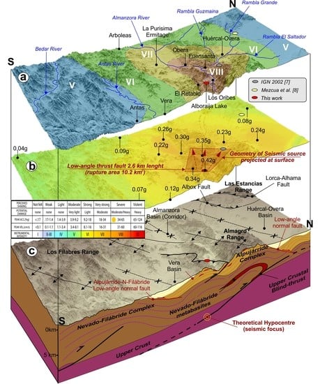
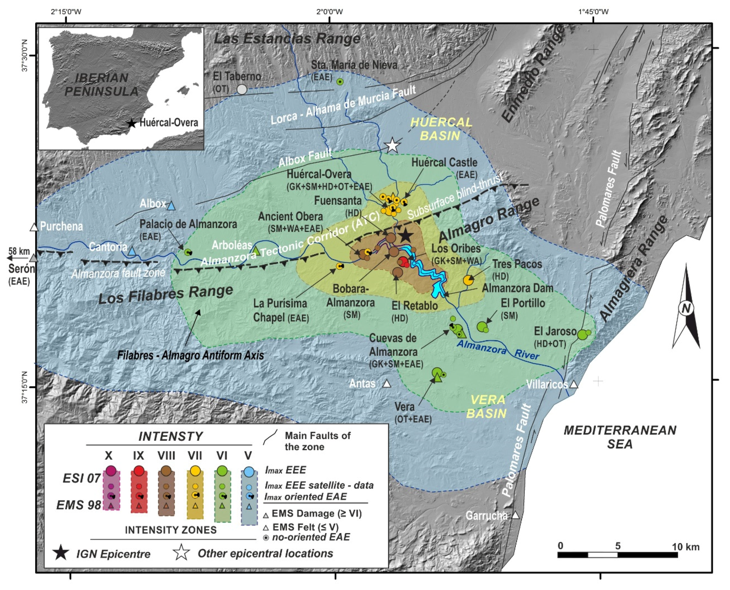
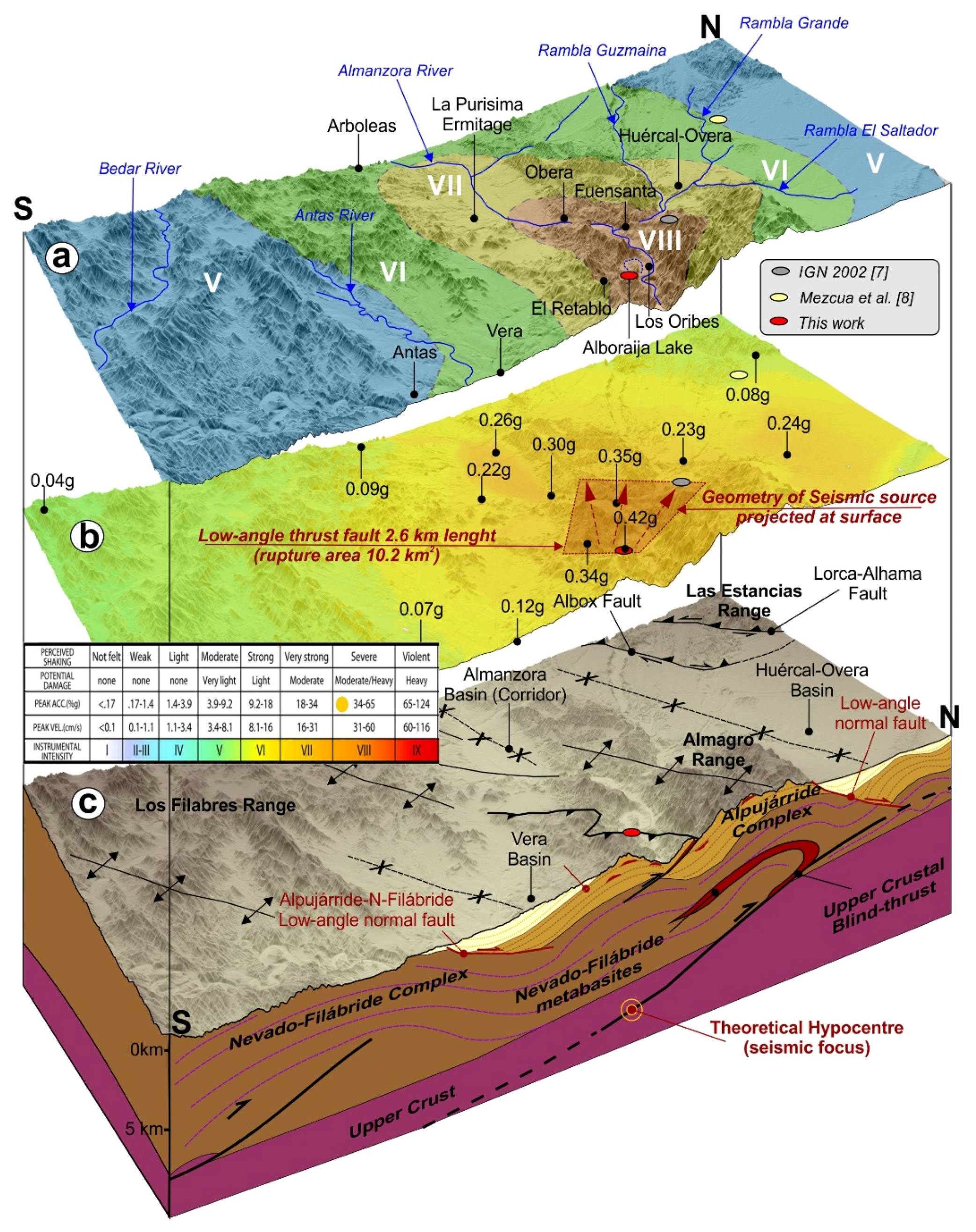
  • Intensity VII affected the Huércal-Overa village, but the real macroseismic zone was located to the south (Almanzora Gorge), reaching a maximum intensity VIII ESI-07 based on natural effects (EEEs). The EMS-ESI hybrid intensity map produced for this earthquake (Figure 2 and Figure 11) clearly illustrates the advantage to combine both intensity scales.
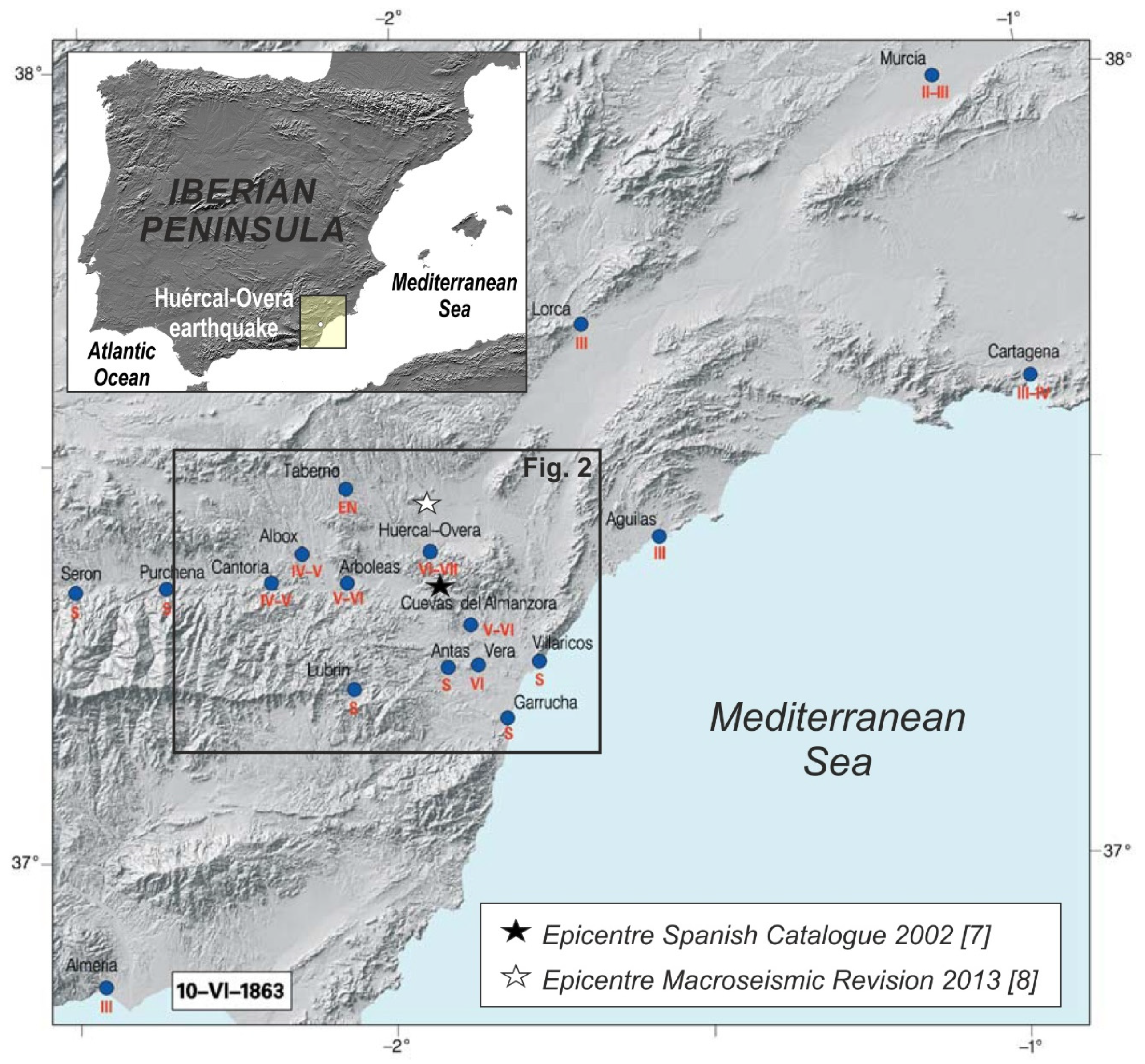
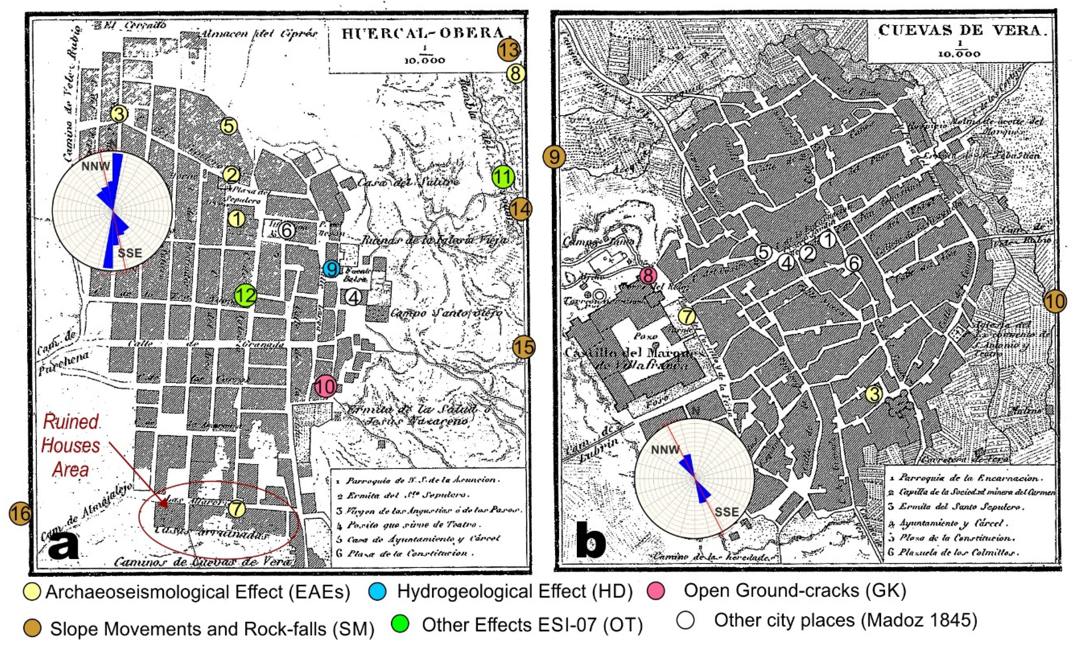
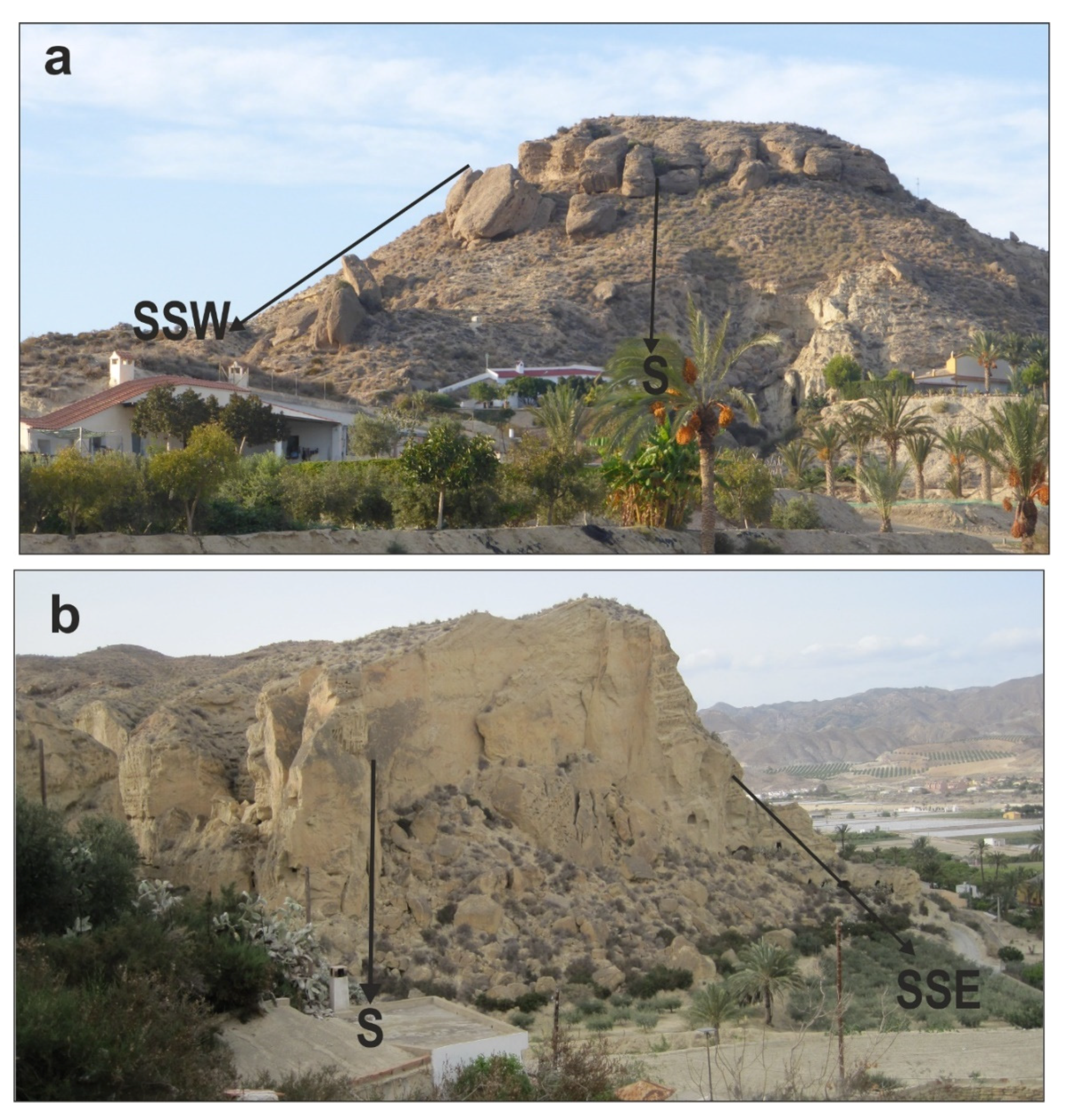
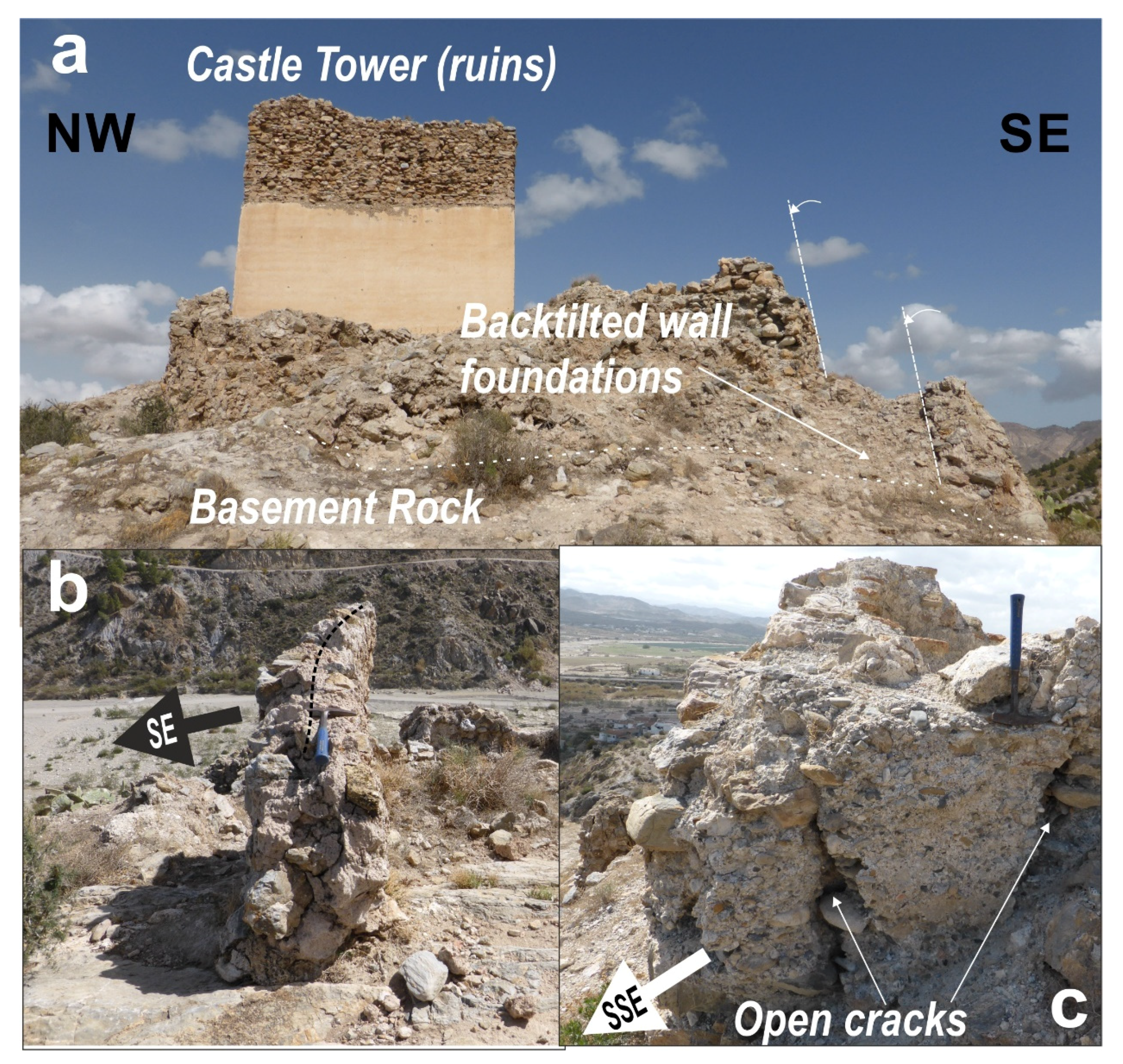
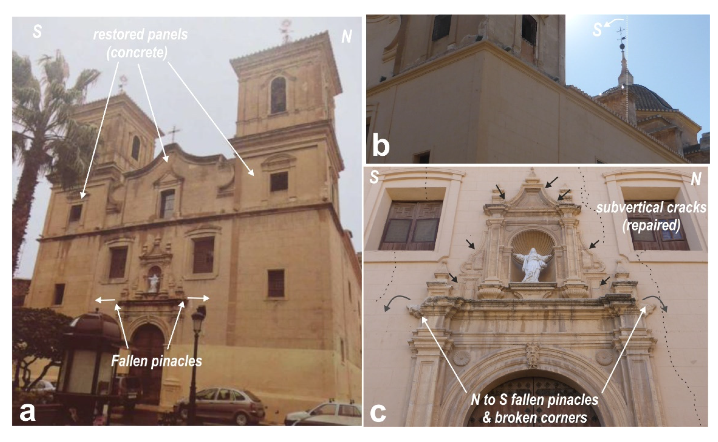
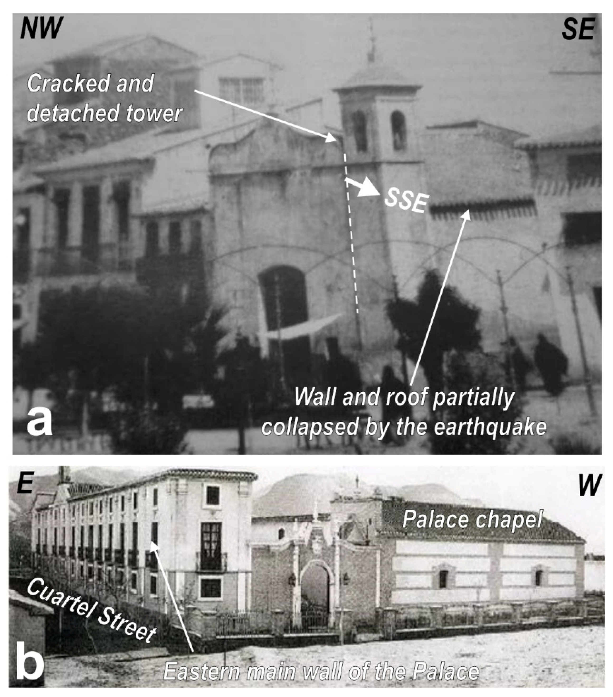
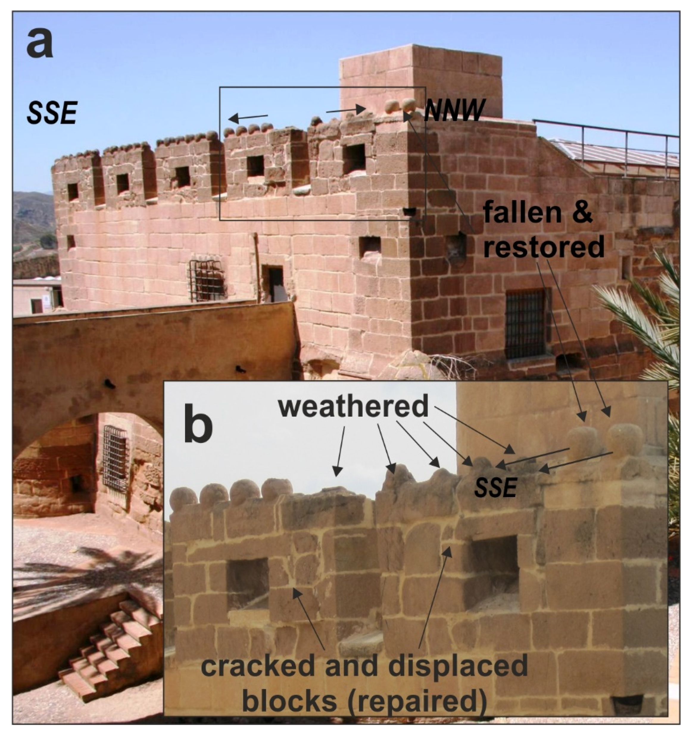
  • The analysis of oriented damage in buildings of the cultural heritage of the area (EAEs), also identified the same macroseismic zone. Despite the recent restorations of most of the affected buildings, available historical descriptions and field inspections help to identify a dominant ground movement in an N-S to NNE-SSW orientation in the localities of Huércal and Cuevas. In the case of the demolished buildings ancient photographs available in different websites facilitated the identification of preferential orientations of structural damage (Figure 9). To the East of the epicenter, data from La Purisima Chapel and the ancient Obera Castle are not conclusive and to the West there is any macroseismic data (Figure 2).
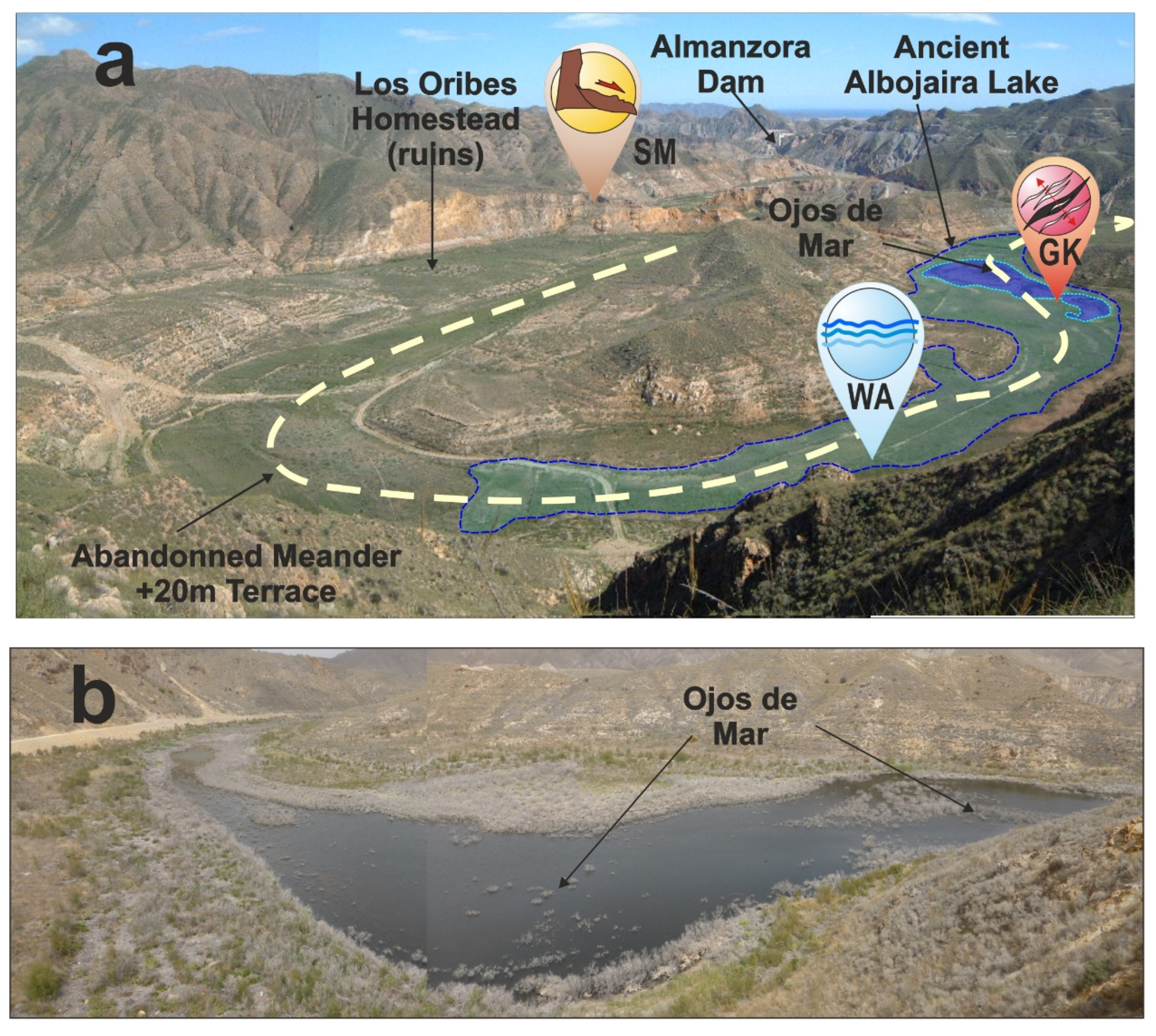
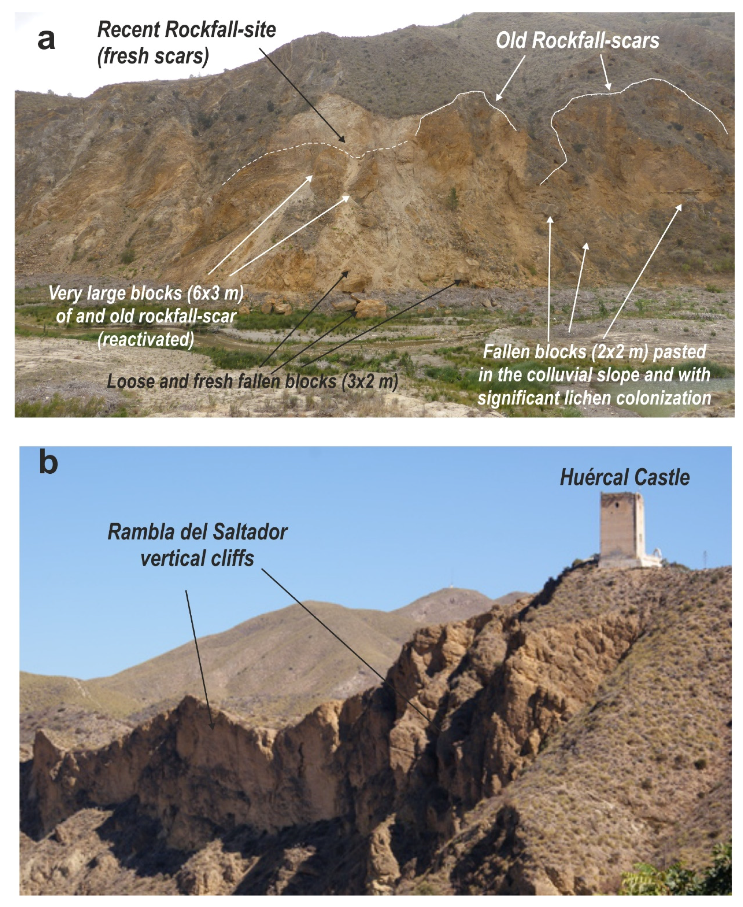
  • This work characterizes the northward crustal blind-thrusting beneath the Almagro Range as the more reliable seismic source for the studied event (Figure 11). Most of the documented environmental damage were concentrated south of the locality of Huércal-Overa, above the upthrown block of the above-mentioned tectonic structure. In this sense, the temporary stop in the water-flow of the Almanzora River, changes in elevation of springs and the disappearance of the Albojaira Lake reported by De Prado [4], will indicate transient coseismic uplift of the upthrown block of the thrust located downstream (Figure 2). Geophysical data indicate that such structure is a low-angle discontinuity verging to the north which develops between c. 9 km (south) to 3 km (north) depth beneath the Almagro Range [25,26] (Figure 11c). In detail, available seismological data indicate that most of the instrumental seismicity in this zone is recorded along and above (shallow events) the blind-thrust with focal solutions compatible with reverse to strike-slip displacements [26].
  • The possibly shallow nature of this low-magnitude event (4.9 Mw), can explain the variety and size of the triggered EEEs. The computed maximum PGA values (0.35–0.38 g) at Los Oribes—Albojaira lake zone (Figure 11b) are in the lower range of intensity VIII ESI-07 (Figure 11a). A comparable maximum PGA of 0.365 g was instrumentally recorded during the 2011 Lorca earthquake (5.1 Mw) in SE Spain [13,47]. This event triggered a total of 251 EEEs, most of them slope movements within intensity zones VI to VIII ESI-07 (135 km2) [46], but also a large amount of oriented building damage (EAEs) in the city of Lorca consistent with the location of the epicenter and preferent ground movement [16]. Considering the differences in population, construction styles and epoch, it can be said that the 1863 Huércal-Overa and the 2011 Lorca earthquakes are comparable in size and had comparable effects. In both cases, the macroseismic areas (whit intensity VIII EEEs) was few kilometers outside of the populated areas [20,39] becoming invisible to EMS analyses and resulting in the underestimation of maximum intensities [7,46].
This ESI-based study strongly supports the use of EEEs in the analysis of well-documented historical earthquakes, which may improve our knowledge of the distribution of ground shaking. The ESI-07 scale is sensitive to environmental damage in urban and non-urban areas and fills intensity data-gaps between populated zones, especially in low-moderate earthquakes. The advantages of the application of ESI-07 practices in depopulated zones largely improve seismic source estimations for historical events for application to future seismic hazard studies.

Supplementary Materials

The following are available online at https://www.mdpi.com/2076-3263/10/8/303/s1, kmz file (GoogleEarth) illustrating the location and description of all the EEEs, EAEs and EMS data listed in Table 1, Table 2 and Table 3.

Author Contributions

Project design, management, conceptualization, coordination, funding acquisition, field work and writing—original draft preparation, P.G.S.; Design of graphic information-software for seismic scenarios, management of information in ArcGis environment and writing—review and editing, J.E.; Design of graphic information-software for intensity maps and visualization, investigation on earthquake effects on cultural heritage, Field work and writing—review and editing, J.L.G.-R.; Investigation of historical and ancient events, management of structural data and writing—review and editing, R.P.-L.; Field work, research on historic documentation and writing—review and editing, E.R.; Structural data management and field work M.Á.R.-P. All authors have read and agreed to the published version of the manuscript.

Funding

This research has been funded by the Spanish Research Project MINECO-FEDER CGL2015-67169-P (QTECSPAIN-USAL). This is contribution of the QTECT-AEQUA Working group.

Acknowledgments

The authors are grateful to anonymous reviewers in the pre-print stage of this paper.

Conflicts of Interest

The authors declare no conflict of interest.

Appendix A

Cover page of the newspaper “La Correspondencia de España” (Madrid) of Saturday 27 June 1863 (nº 1828), describing the damage in Huércal-Overa from a letter sent on 21st June after the main event of the seismic serie (www.huercal-overa:foro.st). Also available at the digital repository of the Spanish National Library: http://hemerotecadigital.bne.es/. The appendix also has a transcription to facilitate the lecture of the original cover-page.
Geosciences 10 00303 i001
Geosciences 10 00303 i002

References

  1. Michetti, A.M.; Esposito, E.; Guerrieri, L.; Porfido, S.; Serva, L.; Tatevossian, R.; Vittori, E.; Audemard, F.; Azuma, T.; Clague, J.; et al. Environmental seismic Intensity Scale ESI 2007. Mem. Descr. Carta Geol. D’Italia 2007, 74, 11–20. [Google Scholar]
  2. Grünthal, G. European Macroseismic Scale 1998: EMS98; Musée Natioal d´Historie Narurelle: Luxembourg, 1988; p. 99. [Google Scholar]
  3. Silva, P.G.; Guerrieri, L.; Michetti, A.M. Intensity scale ESI 2007 for assessing earthquake intensities. In Encyclopedia of Earthquake Engineering; Beer, M., Kougioumtzoglou, I.A., Patelli, E., Au, S.K., Eds.; Springer: Berlin, Germany, 2015; pp. 1219–1237. [Google Scholar]
  4. De Prado, C. Los terremotos de la Provincia de Almería. Rev. Min. 1863, 14, 180. [Google Scholar]
  5. Fernández Bolea, E. Los terremotos de 1863 en la comarca del Levante almeriense. Espiral Cuad. Prof. 2009, 2, 27–40. [Google Scholar]
  6. García Asensio, E. Historia de la Villa de Huércal-Overa y su Comarca Precedida de un Estudio Físico-geológico de la Cuenca del río Almanzora; Martínez y Gimenez: Barcelona, Spain, 1908; p. 295. [Google Scholar]
  7. Martínez Solares, J.M.; Mezcua, J. Catálogo Sísmico de la Península Ibérica (880 a.C. – 1900); Instituto Geográfico Nacional: Madrid, Spain, 2002; p. 253. [Google Scholar]
  8. Mezcua, J.; Rueda, J.; García Blanco, R.M. Iberian Peninsula Historical Seismicity Revisited: An Intensity Data Bank. Seism. Res. Let. 2013, 84, 9–18. [Google Scholar] [CrossRef]
  9. Rodríguez-Pascua, M.A.; Pérez-López, R.; Silva, P.G.; Giner-Robles, J.L.; Garduño-Monroy, V.H.; Reicherter, K. A Comprehensive Classification of Earthquake Archaeological Effects (EAE) for Archaeoseismology. Quat. Int. 2011, 242, 20–30. [Google Scholar]
  10. IGN. Actualización de Mapas de Peligrosidad Sísmica en España 2012; Instituto Geográfico Nacional (IGN): Madrid, Spain, 2013; p. 127. [Google Scholar]
  11. Silva, P.G.; Elez, J.; Giner-Robles, J.L.; Rodríguez-Pascua, M.A.; Pérez-López, R.; Roquero, E.; Bardají, T.; Martínez-Graña, A.M. ESI-07 ShakeMaps for instrumental and historical events in the Betic Cordillera (SE Spain): An approach based on geological data and applied to seismic hazard. Quat. Int. 2017, 451, 185–208. [Google Scholar] [CrossRef]
  12. Atkinson, G.M.; Kaka, S.I. Relationship between felt intensity and instrumental ground motion in the central United States and California. Bull. Seism. Soc. Am. 2007, 97, 497–510. [Google Scholar] [CrossRef]
  13. Faenza, L.; Michelini, F. Regression analysis of MCS intensity and ground motion parameters in Italy and its application in ShakeMaps. Geophys. J. Int. 2010, 180, 1138–1152. [Google Scholar] [CrossRef] [Green Version]
  14. Wald, D.J.; Worden, B.C.; Quitoriano, V.; Pankow, K.L. ShakeMap Manual: Technical Manual, User’s Guide, and Software Guide; U.S. Geological Survey: Boulder, CO, USA, 2005; p. 132.
  15. Worden, C.B.; Gerstenberger, M.C.; Rhoades, D.A.; Wald, D.J. Probabilistic relationships between ground-motion parameters and Modified Mercalli intensity in California. Bull. Seism. Soc. Am. 2012, 102, 204–221. [Google Scholar] [CrossRef]
  16. Rodríguez-Pazcua, M.A.; Pérez-López, R.; Martín-González, F.; Giner-Robles, J.L.; Silva, P.G. Efectos arquitectónicos del terremoto de Lorca del 11 de mayo de 2011. Neoformación y reactivación de efectos en el Patrimonio Cultural. Bol. Geol. Min. 2012, 123, 487–502. [Google Scholar]
  17. Giner-Robles, J.L.; Rodríguez-Pascua, M.A.; Silva, P.G.; Pérez-López, R. Efectos sísmicos en yacimientos arequeológicos: Catalogación y cuantificación arqueosismológica. Bol. Geol. Min. 2018, 129, 451–467. [Google Scholar]
  18. IAEA. The Contribution of Paleoseismology to Seismic Hazard Assessment in Site Evaluation for Nuclear Installations; TEC-DOC 1767; International Atomic Energy Agency: Vienna, Austria, 2015; p. 206. [Google Scholar]
  19. Martínez Solares, J.M. Los efectos en España del terremoto de Lisboa; Dirección General del Instituto Geográfico Nacional (IGN): Madrid, Spain, 2001; p. 756. [Google Scholar]
  20. Silva, P.G.; Rodríguez-Pascua, M.A.; Giner-Robles, J.L.; Roquero, E.; Pérez-López, R.; Huerta, P.; Bardají, T. Anatomy of an Earthquake: Geological analysis of the Huércal-Overa AD 1863 event (Almería, SE Spain). In Proceedings 2ª Reunión Ibérica sobre Fallas Activas y Paleosismología; IBERFAULT II: Lorca, Spain, 2014; pp. 145–148. [Google Scholar]
  21. Silva, P.G.; Rodríguez-Pascua, M.; Giner-Robles, J.; Elez, J.; Huerta, P.; García-Tortosa, F.J.; Azcárate, T.; Perucha, M.A.; Gómez-Diego, P.V.; Perez-Lopez, R.; et al. Catálogo de los efectos geológicos de los terremotos de España, 2ª Ed. Revisada y Ampliada; Serie Riesgos Geológicos y Geotecnia 6; Instituto Geológico y Minero de España (IGME): Madrid, Spain, 2019; p. 804. [Google Scholar]
  22. La Correspondencia de España. Diario universal de noticias, 18 de junio de 1863, nº 1809 (Año XVI); 27 de junio de 1863, nº 1828 (Año XVI). Digital Repository of the Spanish National Library: Madrid, Spain. Available online: http://hemerotecadigital.bne.es/ (accessed on 9 July 2020).
  23. Madoz, P. Diccionario Geográfico-Estadístico-Histórico de España y sus posesiones de Ultramar (Provincia de Almería), 1845-50; Ámbito y Editorial Andaluzas Unidas: Sevilla, Spain, 1988; p. 191. [Google Scholar]
  24. Espinar Moreno, M. Los terremotos históricos de la provincia de Almería. In El estudio de los terremotos en Almería; Instituto de Estudios Almerienses: Almería, Spain, 1994; pp. 115–180. [Google Scholar]
  25. Pedrera, A.; Galindo-Zaldívar, J.; Sanz de Galdeano, C.; López-Garrido, A.C. Fold and fault interactions during the development of an elongated narrow basin: The Almanzora Neogene-Quaternary Corridor (SE Betic Cordillera, Spain). Tectonics 2007, 26, TC6002. [Google Scholar] [CrossRef] [Green Version]
  26. Pedrera, A.; Galindo-Zaldívar, J.; Ruíz-Constán, A.; Duque, C.; Marín-Lechado, C.; Serrano, I. Recent large fold nucleation in the upper crust: Insight from gravity, magnetic, magnetotelluric and seismicity data (Sierra de Los Filabres–Sierra de Las Estancias, Internal Zones, Betic Cordillera). Tectonophysics 2009, 463, 145–160. [Google Scholar] [CrossRef]
  27. Silva, P.G.; Goy, J.L.; Somoza, L.; Zazo, C.; Bardají, T. Landscape response to strike-slip faulting linked to collisional settings: Quaternary tectonics and basin formation in the Eastern Betics, Southeast Spain. Tectonophysics 1993, 224, 289–303. [Google Scholar] [CrossRef]
  28. García-Meléndez, E.; Goy, J.L.; Zazo, C. Neotectonics and Plio-Quaternary landscape development within the eastern Huércal-Overa Basin (Betic Cordillera, south-eastern Spain). Geomorphology 2003, 50, 111–133. [Google Scholar] [CrossRef]
  29. Masana, E.; Pallàs, R.; Perea, H.; Ortuño, M.; Martínez-Díaz, J.J.; García-Meléndez, E.; Santanach, P. Large Holocene morphogenic earthquakes along the Albox fault, Betic Cordillera, Spain. J. Geodyn. 2005, 40, 119–133. [Google Scholar] [CrossRef]
  30. Stokes, M.; Mather, A.E. Tectonic origin and evolution of a transverse drainage: The Rio Almanzora, Betic Cordillera, Southeast Spain. Geomorphology 2003, 50, 59–81. [Google Scholar] [CrossRef]
  31. Audemard, F.; Azuma, T.; Baiocco, F. Earthquake environmental effect for seismic hazard assessment: The ESI intensity scale and the EEE catalogue. In Memorie Descrittive della Carta Geologica d’Italia; Guerrieri, L., Ed.; ISPRA: Rome, Italy, 2015; Volume XCVII. [Google Scholar]
  32. Junta de Andalucia. Manatiales y Fuentes de Andalucia; CSIC-Universidad de Granada: Granada, Spain; Available online: http://www.conocetusfuentes.com/datos_fuente_6653.html (accessed on 20 March 2020).
  33. García-Tortosa, F.J.; López Casado, A.C.; Sanz de Galdeano, C. Estratigrafía y estructura de la Unidad de Los Tres Pacos: La controversia sobre el Complejo “Almagride” en la Sierra de Almagro (Cordillera Bética, Almería). Rev. Soc. Geol. Esp. 2002, 15, 15–25. [Google Scholar]
  34. La Esperanza, Periódico Monárquico. 17 de junio de 1863, nº 5732 (Año XIX), Bibliotéca Nacional de España, Madrid. Available online: http://hemerotecadigital.bne.es/ (accessed on 9 July 2020).
  35. Bretón González, M.; Espinar Moreno, M.; Grima Cervantes, J.; Vidal Sánchez, F. El Terremoto de 1518 en Vera y su comarca (Almería); Aráez Editores: Almería, Granada, 2014; p. 286. [Google Scholar]
  36. Fontenla Ballesta, S. Huércal y Overa Medievales; Editorial Fajardo: Murcia, Spain, 1989; p. 223. [Google Scholar]
  37. Cofradía del Paso Negro, Huercal-Overa. Available online: https://pasonegro.org/historia-y-origen/ (accessed on 10 January 2020).
  38. López Cazorla, L. Pinceladas sobre Almanzora. Rev. Cult. Cantoria 2006, 1, 2–10. [Google Scholar]
  39. Wells, D.L.; Coppersmith, K.J. New empirical relationships among magnitude, rupture length, rupture width, rupture area, and surface displacement. Bull. Seism. Soc. Am. 1994, 84, 974–1002. [Google Scholar]
  40. Serva, L. History of the Environmental Seismic Intensity Scale ESI-07. Geosciences 2019, 9, 210. [Google Scholar] [CrossRef] [Green Version]
  41. Valente, E.; Ascione, A.; Ciotoli, G.; Cozzolino, M.; Porfido, S.; Sciarra, A. Do moderate magnitude earthquakes generate seismically induced ground effects? The case study of the M w = 5.16, 29th December 2013 Matese earthquake (southern Apennines, Italy). Int. J. Earth Sci. 2018, 107, 517–537. [Google Scholar] [CrossRef] [Green Version]
  42. Nappi, R.; Alessio, G.; Gaudiosi, G.; Nave, R.; Marotta, E.; Siniscalchi, V.; Civico, R.; Pizzimenti, L.; Peluso, R.; Belviso, P.; et al. The 21 August 2017 Md 4.0 Casamicciola Earthquake: First Evidence of Coseismic Normal Surface Faulting at the Ischia Volcanic Island. Seism. Res. Let. 2018, 89, 1323–1334. [Google Scholar] [CrossRef]
  43. Gosar, A. Review of seismological investigations related to 1998 Mw5.6 and 2004 Mw5.2 earthquakes in Krn Mountains. Geologija 2018, 62, 61–73. [Google Scholar] [CrossRef]
  44. Pavlides, S.; Papathanassiou, G.; Valkaniotis, S.; Chatzipetros, A.; Sboras, S.; Caputo, R. Rock-falls and liquefaction related phenomena triggered by the June 8, 2008, Mw=6.4 earthquake in NW Peloponnesus, Greece. Ann. Geophys. 2013, 56, S0682. [Google Scholar]
  45. Naik, S.P.; Kim, Y.-S.; Kim, T.; Su-Ho, Y. Geological and Structural Control on Localized Ground Effects within the Heunghae Basin during the Pohang Earthquake (MW 5.4, 15th November 2017), South Korea. Geosciences 2019, 9, 173. [Google Scholar] [CrossRef] [Green Version]
  46. Silva, P.G.; Pérez-López, R.; Rodríguez-Pascua, M.A.; Roquero, E.; Giner Robles, J.L.; Huerta, P.; Martínez-Graña, A.; Bardají, T. Macroseismic analysis of slope movements triggered by the 2011 Lorca Earthquake (Mw 5.1): Application of the ESI-07 scale. Geogaceta 2015, 57, 35–38. [Google Scholar]
  47. Morales, J.; Cantavella, J.V.; Mancilla, F.L.; Lozano, L.; Stich, D.; Herráiz, E.; Martín, J.B.; López-Comino, J.A.; Martínez-Solares, J.M. The 2011 Lorca seismic series: Temporal evolution, faulting parameters and hypocentral relocation. Bull Earthq. Eng. 2014, 12, 1871–1888. [Google Scholar] [CrossRef]
Figure 1. EMS98 Intensity Map of the AD 1863 Huércal-Overa Earthquake included in the Spanish Catalogue of historical earthquakes [7] showing the location of proposed macroseismic epicenters by different authors. The location of the area in the Iberian Peninsula showed in the inset upper map. Modified from the original catalogue [7]. The central quadrangle shows the location of Figure 2.
Geosciences 10 00303 g001
Figure 2. Hybrid EMS98-ESI07 Intensity Map of the AD 1863 Huércal-Overa Earthquake from Environmental (EEEs) and Building (EMS) damage macroseismic data. The map also includes the data on building oriented damage (EAEs) occurred in the Cultural Heritage of the affected zone (North Almeria province, SE Spain). The map displays the most important Quaternary tectonic structures and faults of the area, as well as the main morphostructual features, such as the Almanzora River Gorge, now partially occupied by the Almanzora reservoir.
Geosciences 10 00303 g002
Figure 3. Old City Maps of Huércal-Overa (a) and Cuevas de Almanzora (b) from Madoz [23] (1845–1850) showing the location and orientation (inset rose diagrams) of main EAEs and EEEs around their respective urban areas. (A) Huérccal-Overa (Intensity VII): (1) La Ascensión Church; (2) Santo Sepulcro Chapel; (3) Las Angustias Chapel; (4) Theater; (5) City Hall; (6) Constitution Square; (7) Area of ruined houses around “Las Alfarerías Street”; (8) Huércal Castle; (9) El Caño Spring; (10) Large Ground-crack; (11) Tree shacking at valley floor; (12) Gas Emissions; (13) El Saltador Rockfall; (14–15) Rambla Grande rockfall sites; (16) Rambla Guzmaina rockfall (Piedras Rajadas). (B) Cuevas de Almanzora (Intensity VI): (1) La Encarnación Church; (2) Chapel of the El Carmen Mining Society; (3) Santo Sepulcro Chapel; (4) City Hall; (5) Constitution Square; (6) Colmillos Square; (7) Villafranca Palace; (8) Largest Ground-crack caused by the earthquake; (9) Large rockfall site; (10) El Portillo hill. Note the old denomination of “Huércal-Obera” in map (a).
Geosciences 10 00303 g003
Figure 4. The Albojaira Lake at Los Oribes within the Almanzora Canyon (Intensity VIII). (a) View of the abandoned meander of the Almanzora River (terrace +20 m) where was located the Albojaira (in Arab: Al Bujaira) Lake emptied during the earthquake as a consequence of large ground-cracking in the ancient lake floor. The location of main EEEs and other geomorphological features, such as the ancient lake contour and the site of the “Ojos de Mar” (permanent water bodies) is also illustrated. (b) Southern view of the presently active “Ojos de Mar” due to the construction of a large dam within the Almanzora Gorge few kilometers downstream the site (artificially upraised groundwater table).
Geosciences 10 00303 g004
Figure 5. (a) Major rockfall site within the Almanzora Gorge near its junction with Bobara Rambla at la La Fuensanta site (Intensity VIII). Note the occurrence of fresh and ancient rockfall scars because of the repetitive nature (reactivations) of these slope processes at this site. (b) Vertical cliffs of El Saltador Rambla where rockfalls occurred during the earthquake. At the top of the cliff is the ancient Islamic Castle of Huércal (Intensity VII). This photo was taken before the recent reconstruction of the castle.
Geosciences 10 00303 g005
Figure 6. Slope movements triggered by the earthquake around Cuevas de Almanzora, about 9 km SSE of the epicenter (Intensity VI). (a) El Portillo Hill (structural butte) displaying its strongly ruptured caprock and oriented rockfalls towards de ESE-SSE. (b) Rock-fall site in the vertical cliff of the Almanzora valley north of Cuevas de Almanzora affecting to ancient cave-houses. Note the occurrence of ancient and recent rockfalls.
Geosciences 10 00303 g006
Figure 7. Archeoseismological damage in the ancient Obera Castle (Intensity VIII). (a) View from the west of the ruins of the tower, as well as the back-tilted wall foundations towards the SE as a consequence of slope movements. (b) Deformed and tilted wall-remain towards de SE. (c) Large open cracks in the tower foundations with displacement towards de SSE.
Geosciences 10 00303 g007
Figure 8. Archaeoseismological damage in the “La Concepción parish Church” at Huércal-Overa (Intensity VII). (a) View of the eastern main façade of the church showing the location of the N to S fallen pinnacles of the portico and the restored upper panels of the towers during the 1950s decade. (b) View of the southwards tilted iron cross topping the dome of the church. (c) Detail of the eastern portico of the church displaying the broken cornices where was placed the fallen pinnacles (N-S). Dotted lines highlight still visible subvertical open cracks (mm size). Black arrows indicate the occurrence of cm-scale displacements and extrusions of the masonry blocks in the upper zone of the portico.
Geosciences 10 00303 g008
Figure 9. (a) Ancient photo of el Santo Sepulcro Chapel in Huércal-Overa (Intensity VII) before its demolition during the last decade of the 19th Century (https://pasonegro.org/historia-y-origen/). The photo locates the orientation (SSE) of the damaged bell-tower and the SSE wall and roof of the old chapel. (b) Old photo of the Almanzora Palace in the Almanzora village (Intensity VI) showing the eastern main wall of the palace damaged during the earthquake (https://franciscooller.wixsite.com/almanzora/ palacio-de-almanzora).
Geosciences 10 00303 g009
Figure 10. Archeoseismological damage at the Villafranca Palace in Cuevas de Almanzora (Intensity VI). (a) Overall view of the Villafranca Palace showing its NW corner, where De Pardo [4] documented the fallen stone-balls decorating the battlements. Note the weathered stage of the original stone-balls and the fresh-one of the recently replaced fallen balls, as well as the overall cracked stage of the battlements of the eastern wall (especially those of the NW corner). (b) Detail of the NW corner of the palace illustrating the main features of building damage and reparation.
Geosciences 10 00303 g010
Figure 11. 3D views of the area affected by the 1863 Earthquake. (a) Projection of the EMS-ESI hybrid intensity map showing the intensity zones and the location of most of the localities affected by intensity ≥ VII, as well as the proposed locations for the macroseismic epicenter. (b) Projection of the Shakemap (USG-Style) illustrating theoretical PGA values (g units) reached in different locations using the upper-crust blind thrust [13]. Intensity-PGA scale adapted from the USGS ShakeMap Program [14]. (c) Projection of the Sketched geological structure of the zone and the proposed seismic source from geophysical [26] and geological data [27].
Geosciences 10 00303 g011
Table 1. ESI-07 Intensity points (EEEs) identified from historic reports, documents and field inspection. Note that EMS data are not available for the depopulated zone of the Ancient Obera and the Almanzora Gorge, where most intense shaking occurred [4]. Updated and expanded from Reference [21]. EEEs classified following the nomenclature of the ESI-07 Scale [3]: GK (Ground Cracks); SM (Slope Movements); HD (Hydrogeological anomalies); WA (Water bodies anomalies); OT (other effects: Gas Emissions, Tree shaking, etc.). NE refers to natural effects in the EMS-98 scale [2].
Locality/Site (Effect)LongitudeLatitudeDistance (km)EMS-98ESI-07
01 Albojaira Lake (WA)1°55′42.8″ W37°20′30.7″ N2.8No DataVIII-IX
02 Albojaira Lake (GK)1°55′55.4″ W37°20′36.7″ N2.6No DataVIII-IX
03 Bobara, La Fuensanta Spring (HD)1°56′37.1″ W37°21′36.3″ N1.2No DataVIII
04 Santa Barbara, Watermills (WA)1°57′51.0″ W37°20′55.0″ N3.5No DataVIII
05 El Retablo Hill springs (HD)1°56′14.9″ W37°19′48.0″ N4.1No DataVIII
06 Almanzora Canyon (SM)1°56′26.4″ W37°20′52.1″ N2.1No DataVIII
07 Obera Antigua, Castle Hill (GK)1°57′44.1″ W37°21′2.2″ N3.1No DataVII
08 Huércal, El Caño Spring (HD)1°56′34.4″ W37°23′8,9″ N2.5VI-VIIVII
09 Huércal, Carretera St. (GK)1°56′31.6″ W37°23′9.2″ N2.3VI-VIIVII
10 Huércal (OT: Gas Emissions)1°56′31.6″ W37°23′9.2″ N2.4VI-VIIVII
11 Huércal, El Saltador R. (SM)1°56′4.4″ W37°23′15.87” N2.3VI-VIIVII
12 Huércal, Grande R. (SM)1°56′19.0″ W37°22′57,50″ N1.9VI-VIIVII
13 Huércal, (OT: Tree shaking)1°56′17.1″ W37°23′8.4″ N2.2VI-VIIVII
14 Huércal, Piedras Rajadas (SM)1°56′58.2” W37°22′51.8″ N2.1VI-VIIVII
15 Los Oribes, Caserío (SM)1°55′30.1” W37°20′28.7″ N2.9No DataVII
16 Tres Pacos Mine Spring (HD)1°52′19.8″ W37°20′4.2″ N6.5No DataVII
17 Cuevas de Almanzora (GK)1°52′46.6″ W37°17′49.3″ N8.9V-VIVI
18 Cuevas de Almanzora (SM)1°53′9.1″ W37°17′58.5″ N8.5V-VIVI
19 Cuevasa, El Portillo Hill (SM)1°51′38.0″ W37°17′58.7″ N8.8No DataVI
20 La Jarosa, Constancia Mine (HD)1°44′58.0”W37°17′47.7″ N17.6No DataV
21 La Jarosa, San Antonio Mine
(OT: Spontaneous ventilation)
1°44′55.8″ W37°17′48.7″ N17.4No DataVI
22 Vera (OT: Gas Emissions)1°52′5.8″ W37°14′46.9″ N15.5VIVI
23 El Taberno, Spring (?) (OT)2°4′37.8″ W37°28′5.9″ N17.0Natural EffectsIV-V
Table 2. Archaeoseismological damage (EAEs) identified from historic reports, documents and field inspection. Updated and expanded from Silva et al. [21]). * Buildings eventually demolished after the earthquake. For location information, see Figure 2.
Locality, Site LongitudeLatitudeDistance (km)EMS-98ESI-07 (Zone)
24 Obera Antigua, Castle (ruins)1°57′44.1″ W37°21′2.2″ N3.1No DataVII
25 Obera La Purísima Chapel * 1°59′34.6″ W37°20′23.5″ N5.9No DataVII
26 Huércal-Overa La Asunción Church1°56′34.9″ W37°23′20.9″ N2.6VI-VIIVII
27 Huércal-Overa Santo Sepulcro *1°56′35.5″ W37°23′22.7″ N2.7VI-VIIVII
28 Huércal-Overa Angustias Church1°56′42.5″ W37°23′26.2″ N2.9VI-VIIVII
29 Huércal-Overa, Castle (ruins)1°56′07.2″ W37°23′12.8″ N2.3VI-VIIVII
30 Huércal-Overa, City Hall1°56′37.2″ W37°23′26.2″ N2.6VI-VIIVII
31 Cuevas, Villafranca Castle1°52′58.1″ W37°17′49.5″ N9.1V-VIVI
32 Cuevas, Santo Sepulcro Chapel1°52′41.8″ W37°17′42.7″ N9.3V-VIVI
33 Vera, Padres Mínimos Convent1°52′04.9″ W37°14′51.6″ N15.5VIVI
34 Almanzora, Palacio de Almanzora2°8′05.9″ W37°20′51.5″ N18.1No Data VI
35 Santa María de Nieva Church *1°59′22.6″ W37°27′38.2″ N12.8No Data≤V
36 Serón Castle2°30′37.2″ W37°20′36.3″ N51.3Felt (≤V)≤V
Table 3. EMS original data for the studied earthquake [7]. Note that there are only six localities with EMS intensity assessments around the epicentral area (*). ESI-07 assessments identify the intensity or intensity zone in which the specific locality is placed. For location see Figure 2.
LocalityLongitudeLatitudeDistance (km)EMS-98ESI-07
01 Huércal Overa *1°56′34.9″ W37°23′20.92″ N2.6VI-VIIVII
02 Cuevas Almanzora *1°52′58.1″ W37°17′49.5″ N9.1V-VIVI
03 Vera *1°52′04.8″ W37°14′51.6″ N15.5VIVI
04 Arboleas *2°4′30,1″ W37°21′7,3″ N12.5V-VIVI (Zone)
05 Albox*2°9′03.4″ W37°23′12.9″ N19.1IV-VV (Zone)
06 Cantoria *2°11′33.9″ W37°21′9.1″ N22.9IV-VV (Zone)
07 Antas 1°55′02.5″ W37°14′43.4″ N13.5Felt (≤V)V (Zone)
08 Villaricos1°46′29.3″ W37°14′43.4″ N18.9Felt (≤V)V (Zone)
09 Lubrín2°3′058.8″ W37°12′55.8″ N20.0Felt (≤V)No Data
10 Garrucha1°49′18.3″ W37°11′4.4″ N22.2Felt (≤V)No Data
11 Purchena2°21′40.0″ W37°20′51.3″ N37.8Felt (≤V)No Data
12 Serón2°30′39.1″ W2°21′40.0″ N51.7Felt (≤V)No Data
13 Águilas1°34′52.4″ W37°24′5.2″ N31.2IIINo Data
14 Lorca1°41′58.3″ W37°40′32.0″ N40.8IIINo Data
15 Almería2°28′2.9″ W36°50′16.6″ N75.0IIINo Data
16 Cartagena0°58′58.6″ W37°36′7.8″ N87.8III-IVNo Data
Note: Spanish names of streets, springs, sites, lakes, religious buildings, etc., in text will be in “quotations marks”. Texts in “quotations marks and italics” correspond to the translated transcriptions of original descriptions in historical sources.

