Article

Geology of the Epicentral Area of the November 23, 1980 Earthquake (Irpinia, Italy): New Stratigraphical, Structural and Petrological Constrains

1
Consiglio Nazionale delle Ricerche, ISMAR, 80133 Naples, Italy
2
Università Federico II, 80138 Naples, Italy
3
Dipartimento di Biologia, Ecologia e Scienze della Terra, Università della Calabria, 87036 Rende (CS), Italy
*
Author to whom correspondence should be addressed.
Geosciences 2020, 10(6), 247; https://doi.org/10.3390/geosciences10060247
Submission received: 15 May 2020 / Revised: 18 June 2020 / Accepted: 23 June 2020 / Published: 25 June 2020

Abstract

:
The geology of the epicentral area of the 1980 earthquake (Irpinia-Lucania, Italy) is described with new stratigraphic, petrographic and structural data. Subsurface geological data have been collected during the studies for the excavation works of the Pavoncelli bis hydraulic tunnel, developing between Caposele and Conza della Campania in an area that was highly damaged during 1980 earthquake. Our approach includes geological, stratigraphic, structural studies, and petrological analyses of rock samples collected along the tunnel profile and in outcropping sections. Stratigraphic studies and detailed geological and structural mapping were carried out in about 200 km2 wide area. The main units cropping out have been studied and correlated in order to document the effects of tectonic changes during the orogenic evolution on the foreland basin systems and the sandstone detrital modes in this sector of the southern Apennines. The multi-disciplinary and updated datasets have allowed getting new insights on the tectono-stratigraphic evolution and stratigraphic architecture of the southern Apennines foreland basin system and on the structural and stratigraphic relations of Apennines tectonic units and timing of their kinematic evolution. They also allowed to better understand the relationships between internal and external basin units within the Apennine thrust belt and its tectonic evolution.

1. Introduction

The southern Apennines divide area between Sele river and Ofanto river valleys (southern Italy) represents a key sector for analyzing the paleogeographic conditions and the geodynamic evolution of the Apennine thrust belt. This area is located among the Irpinia, Cilento and Lucania sectors (Figure 1) and is characterized by very high seismic hazard due to the recurrence of strong earthquakes in the last centuries [1,2,3]. Indeed, the 23rd November 1980 Irpinia-Lucania, earthquake (MS 6.9—Imax X MCS) [4,5,6,7,8] has been the most devastating seismic event occurred in southern Apennines in the 20th century in terms of loss of human life and destruction of cultural heritage (Figure 2). The earthquake caused also severe structural damages to major civil engineering works throughout Irpinia sector, as for example to the Pavoncelli hydraulic tunnel located between Conza dam and Caposele springs, and relevant hydrogeological changes to several springs (i.e., Sanità spring at Caposele showed an abnormal, temporary increase in discharge from 4.35 to 7.32 m3/s in January 1981) [9,10,11]. Moreover, a strong ground deformation was caused by the seismic shakings between 30 and 74 cm in height, as resulting by topographic leveling carried out in 1981 near Sella di Conza area [5,7,9,10,12,13,14,15]. The Pavoncelli water supply tunnel was built in 1911 [16] and runs just through the epicentral area, sustaining relevant damage consisting of crushing of sidewalls and roof and in vertical to transversal ruptures of the design section [10].
The high level of occurred damage was due to both the ineffectiveness of the technical rules in force at that time for engineering works and buildings and the poor geological knowledge of the stricken territory regarding to several aspects (seismology, stratigraphy, tectonics, and geomorphology). For example, during the 1980s–early 1990s, the regional geological framework of this area was based on the geological surveys made mainly during 1960s–1970s for the old geological sheets at 1:100,000 scale [17,18] that were summarized in the Bonardi et al. [19] geological map. A great improvement for the regional geology framework was done during late 1910s–2010s within the national CARG (nuova CARtografia Geologica) project for the new geological map of Italy at 1:50,000 scale [20,21], whose results were summarized in the Bonardi et al. [22] geological map.
In recent years, new relevant data have been collected in the study area, thanks to the geological study and investigations for the project for the works of the Pavoncelli-bis hydraulic tunnel that was designed for replacing the old Pavoncelli tunnel, which was strongly damaged during the 1980 earthquake.
The main aim of the paper is further analyzing the relationships between internal and external basin units of southern Apennine orogenic belt and constrain its paleogeographic and tectonic evolution. Indeed, the multi-disciplinary updated datasets have allowed getting new insights on the tectono-stratigraphic evolution and stratigraphic architecture of the southern Apennines foreland basin system and on the structural and stratigraphic relations of Apennines tectonic units and timing of their kinematic evolution.

2. Geological Setting

The southern Italy thrust belt preserves key geodynamic signatures from the Pangaea breakup to the Tethys opening and its closure during the growth of the mountain chains. These paleogeographic domains include the inner domain (i.e., Paleozoic continental-crust sections), the oceanic realm (the Flysch Basin domain), and the external domains including foreland successions (carbonate platform to basin) and under plate stratigraphy (e.g., [25] and bibliography therein). The stratigraphic, tectonic, and paleogeographic relationships between internal and external basin units are an unravelled issue in the scientific debate about southern Apennines geology [22,26,27,28,29].
The “Liguride Complex Auct.” and the “Sicilide Complex Auct.” successions [30] represent remnants of deposition in a Meso-Cenozoic remnant ocean basin related to the western subduction of the Adria oceanic lithosphere beneath the Iberia or Mesomediterranean microplate [25,31,32]. The Liguride Complex records the consumption of the oceanic crust and the accretionary processes along the Adria margin, and the continental accretionary processes of the Calabrian Terranes [33]. The subduction has been active for all the Paleogene and earliest Miocene, producing an accretionary prism [31], and a diffuse calcalkaline volcanism in western Sardinia.
In response of E-NE accretionary processes along the Adria plate, immense volume of turbiditic sedimentation took place in the Apenninic domain during early to middle Miocene. Here, the foreland basin system developed over deformed remnant-ocean basin terranes during the early-to-middle Miocene, over Lagonegro basin and inner Apennine platform units during the upper Miocene, and finally over the previous deformed units and the western margin of the Apulia platform during the Pliocene to Quaternary [33,34,35,36]. The foreland basin system migrated in time, and siliciclastic and carbonate deposits, filling the wedge-top and the foredeep, were derived from progressive unroofing of the Calabrian crustal block or from erosion of the forebulge [25,32,37,38].
The Tyrrhenian back-arc extension of the last 10 Ma is responsible for the fragmentation and dispersion of pieces of the Iberian and European plates (Calabria, Sardinia, Corsica), and increased the displacement of the accretionary prism over the Adria plate, the eastward migration of the magmatic arcs, and the roll-back of the Adriatic lithosphere [39,40,41].
More in detail, the Southern Apennine consists of a north-east verging thrust and fold belt, interposed between the back-arc Tyrrhenian basin, to the west, and the undeformed Apulian-Adriatic foreland, to the east. On the whole, its structural setting is the result of mainly compressive tectonic events, related to the subduction followed by the roll-back of the Adria plate, followed by new tectonic phases related to the opening, since the late Miocene, of the Tyrrhenian sea [40,41,42]. Structural complexity characterizes the whole orogenic evolution of the EastNorthEast-verging fold-and-thrust belt system, but the major imbrications result from the post-Messinian thrusting and refolding of more ancient structures; this breaching [43] developed after the duplexing of the deep Apulian units [27]. Finally, the belt is widely affected by Plio-Quaternary strike-slip and extensional faults.
Several model and interpretations of stratigraphic and paleogeographic settings have been proposed referring to the different carbonate platform and pelagic basin successions cropping out in mountain belts. In detail, along the axial belt of the southern Apennines several basinal successions crop out that are mainly made of calcareous-mudstone sequences; they have been alternatively assigned to different tectonic units (i.e., Liguride, Parasicilide, Sicilide, Sannio, Lagonegro I and II), belonging to both Molise, Lagonegro, and Lucanian basins, following different interpretations and paleogeographic models [22,23,25,26,27,28,29,30,33,41,44,45,46,47,48,49,50,51,52,53,54].
Stratigraphic successions formed by the Argille Variegate Group (Argille Varicolori inferiori, Sant’Arcangelo Fm. and Argille Varicolori Superiori) followed by Tufiti di Tusa Fm. or Corleto Sandstone Fm. were deposited in external Lucanian Basin and can be referred to Sicilide Unit. The very similar stratigraphic successions, formed by Argille Varicolori Fm. and Corleto Perticara Fm., followed by the Tufiti di Tusa Fm. or Paola Doce Fm. conformably passing to Numidian Flysch Fm., are referred to the central axial sector of the Lagonegro basin, namely to the Fortore unit. The key difference is that the Sicilide Unit was deformed (in the southern Apennine sector) by orogenic phases in the early Miocene, before the deposition of the Numidian Flysch that unconformably cover them. The Fortore Unit was deformed later during the middle-late Miocene and so the Numidian Flysch conformably lays within the sequences [22,23,27]. Due to the uncertainty in the reconstruction of the stratigraphic succession, the Sannio unit has been considered both of internal or external origin, and their interpretation has been finally proposed by Di Nocera et al. [26] as northern inner part of the Lagonegro-Molise basin.
In this paper, we refer to the pre-orogenic paleogeographic model proposed by Pescatore et al. [54,55], Di Nocera et al. [27] and Critelli [25] for the southern Apennines sector. The model shows four main paleogeographic realms:
Lucanian Basin; it is the westernmost, oceanic basin where the stratigraphic successions of the Liguride and Parasicilide Complex [31,56] and the Sicilide Complex [30] are deposited.
  • Apenninic carbonate Platform: this is an isolated platform bank between the oceanic realm of the Lucanian Ocean, to the west, and the deep-marine Lagonegro-Molise basin, to the east; this platform consists of thick, shallow-marine carbonate strata from the Late Triassic to early Miocene. The mostly continuous Mesozoic succession is formed by carbonate deposits related to a carbonate platform and its margins [57,58,59] with several evidences of platform emersion or drowning during Cretaceous. Main tectonic units are Alburno-Cervati, Mt. Picentini, Mt. Marzano, Mt. Maddalena, Mt. Croce units.
  • Lagonegro-Molise Basin: this is located eastward of the carbonate platform and characterized by three different sectors, i.e., western, central, and eastern ones [29,60]. The Lagonegro II [61,62], Monte Arioso [29], Frigento [26], and Sannio [27,55,60] units refer to the internal, western portions of the basin; they are formed by calciclastic deposits produced by the erosion of the western margin of the Apenninic platform, interbedded with hemipelagic clays and marls. The Lagonegro I [61,62], Groppa d’Anzi [29], and Fortore [54,55,60] units refer to the axial sector of the basin and are formed by cherty calcareous-mudstone sequences. The Campomaggiore, Daunia, and Vallone del Toro units [27,63,64,65] refer to the eastern sectors and are characterized by clays and marls with calciclastic layers produced by erosion of the western margin of the Apulian platform.
  • Apulian carbonate Platform: this includes a more than 7000 m thick successions formed by Permian siliciclastics, Late Triassic evaporitic sequences (Anidridi di Burano Fm.), followed by Mesozoic and Cenozoic to earliest Pleistocene carbonate deposits of neritic environment [66,67].
In the Southern Apennines synorogenic sequences, carbonate sand and siliciclastic turbidite strata are widespread on diverse paleogeographic domains including the frontal portions of the Mesomediterranean microplate (Paludi and Stilo-Capo d’Orlando formations, late Oligocene to early Miocene), the Lucanian ocean basin (siliciclastic and carbonate turbidites of Monte Sant’Arcangelo, Corleto, Albanella, Colle Cappella, and Tufiti di Tusa Formations, early Miocene), and the Africa-Adriatic plate (Numidian Sandstone and Serra Palazzo formations, early-middle Miocene). Moreover, there are several sequences of foreland basin systems (Cilento Group, Tortonian-to early Pliocene clastics) that were first filled by deep-marine quartzarenite and carbonatoclastic turbidite sand derived from craton and foreland areas and were later filled by deep-marine quartzolithic and quartzofeldspathic turbidite sands. Minor volcaniclastic turbidite sandstone strata are locally deposited; they are derived from active volcanic arc source (e.g., Oligo-Miocene Sardinian Volcanic Arc; e.g., [25,32,68].
The carbonate turbidites are dominant in the Monte Sant’Arcangelo Formation and they are composed of abundant intrabasinal and minor extrabasinal carbonate grains. The Cilento Group (Pollica fm., S. Mauro fm.) is the largest exposed siliciclastic basin sequence in southern Italy [38,69]. It is a typical mixed siliciclastic/calciclastic turbiditic suite, over 2000 meters in thickness, including thick layers of resedimented marls (megabeds) and olistostromes made up of extrabasinal materials emplaced by catastrophic marine gravity flows [32]. Three main contemporaneous submarine fans developed in the early-middle Miocene, in a syntectonic wedge-shaped basin [32,70]. The middle Miocene to Pliocene southern Apennine clastics can be grouped in five key intervals [23,27,71,72]:
  • Numidian Sandstone, mostly formed by Langhian quartzarenites and conformable Serravallian post-Numidian successions, formed by mixed quartzofeldspathic sandstones and calciclastic arenaceous-pelitic beds (foreland depozones);
  • Langhian to Tortonian San Giorgio Fm. and Serra Palazzo Fm., mostly composed of quartzofeldspatic sandstones and calciclastic arenaceous beds (foredeep depozone);
  • Tortonian to Early Messinian, quartzose-feldspatic and partly sedimentary carbonatoclastic petrofacies, wedge-top successions (Gorgoglione, Castelvetere, and San Bartolomeo fms.);
  • Late Messinian quartzolithic to quartzofeldspatic sandstones (Anzano Molasse and Tufo-Altavilla units; Crotone basin sequence), which can be referred to infilled wedge-top basins;
  • Unconformity-bounded Pliocene quartzofeldspatic sandstone strata (wedge-top depozones), characterized by strong synsedimentary tectonic activity.

3. Methods

Our approach includes geological, stratigraphic, structural, and petrological analyses. Stratigraphic studies, detailed geological and structural mapping (at 1:5000 scale) were carried out in about 200 km2 wide area (Figure 3). The reference lithostratigraphy of the studied geological units and the biostratigraphy data that characterize the studied sections derive from the Sheets n° 450 and 468 of the Geological Map of Italy [20,21]. Stratigraphic sections of geological units defined here provide a detailed stratigraphic framework for the petrographic and tectonostratigraphic analyses.
Subsurface geological data were obtained by detailed stratigraphic and structural surveys made in some key sections of the tunnel, lithological analyses of the excavated materials (i.e., spoil) integrated by petrological analyses of rock samples collected along the tunnel profile, and analysis of the stratigraphy of 20 boreholes up to 350 m in depth.
The arenite-dominated successions have been sampled for compositional analysis along some outcrop and tunnel stratigraphic sections. Twenty-one medium- to coarse-grained sandstones samples were selected for composition analyses. They were impregnated in epoxy resin under vacuum, thin-sectioned, and stained for calcium plagioclase and potassium feldspar identification with hydrofluoric acid and sodium-cobaltonitrite, respectively.
The modal sandstone composition is determined by point-counting on stained thin sections. Counting was performed on all samples using the Gazzi-Dickinson method [73,74,75]. The framework grain types that are used for discussions of detrital modes are those of Dickinson [76,77], Zuffa [74,75], Critelli and Le Pera [69], Critelli and Ingersoll [78], and Caracciolo et al. [79,80], and comprise:
(a)
Quartz grains, including monocrystalline quartz grains (Qm), polycrystalline quartzose lithic fragments (Qp), and total quartzose grains (Qt = Qm + Qp);
(b)
Feldspar grains (F), including both plagioclase (P) and potassium feldspar (K);
(c)
Aphanitic lithic fragments (L), as the sum of volcanic/metavolcanic (Lv and Lvm), sedimentary (Ls) and metasedimentary (Lm; including Lsm as the sum of Ls and Lm). Carbonate lithic fragments have been reported in Ls (namely, extrabasinal carbonate grains [74,75,81]), because of their importance and occurrence in detrital modes of Apenninic sandstones;
(d)
Phaneritic and aphanitic rock/lithic fragments (R), recalculated by point-counting of specific assignment of Lm, Lv, Ls lithic fragments plus quartz, feldspar, micas, and dense minerals in coarse-grained polymineralic fragments in which these minerals individually are larger than the lower limit of the sand range (0.0625 mm), that during counting are summed as quartz (Qm) and feldspar (F) or micas or dense mineral grains (e.g., [69,73,74,75,78]).
For diagrams, the proportions of quartzose grains, feldspar grains and aphanitic lithic fragments are recalculated to 100 percent, and summary detrital modes are then reported as Qt%–F%–L% and Qm%–F%–Lt%. Description of sandstone petrofacies includes values of QmFLt%. General descriptions of changing nature of detrital budget in terms of calculations of both phaneritic and aphanitic rock/lithic fragments are also included in the petrofacies definition.

4. Results

The Sella di Conza study area is located along the southern Apennines Mts. divide at the borders along the Irpinia, Cilento, and Lucania sectors (Figure 1). The rugged landscape is characterized by high carbonate mountain reliefs, with the Picentini Mts. to the west and the Mt. Marzano massif to the east (Figure 2). They are separated by the smooth and wide upper Sele river and Ofanto river valleys. The former develops in a large tectonic depression bounded by roughly N-S trending structural lineaments, where Liguride and Sicilide units largely crop out. Northward, the Ofanto river valley develops along transversal active seismo-tectonic structures, which caused the 1980 Irpinia earthquake (Figure 2).

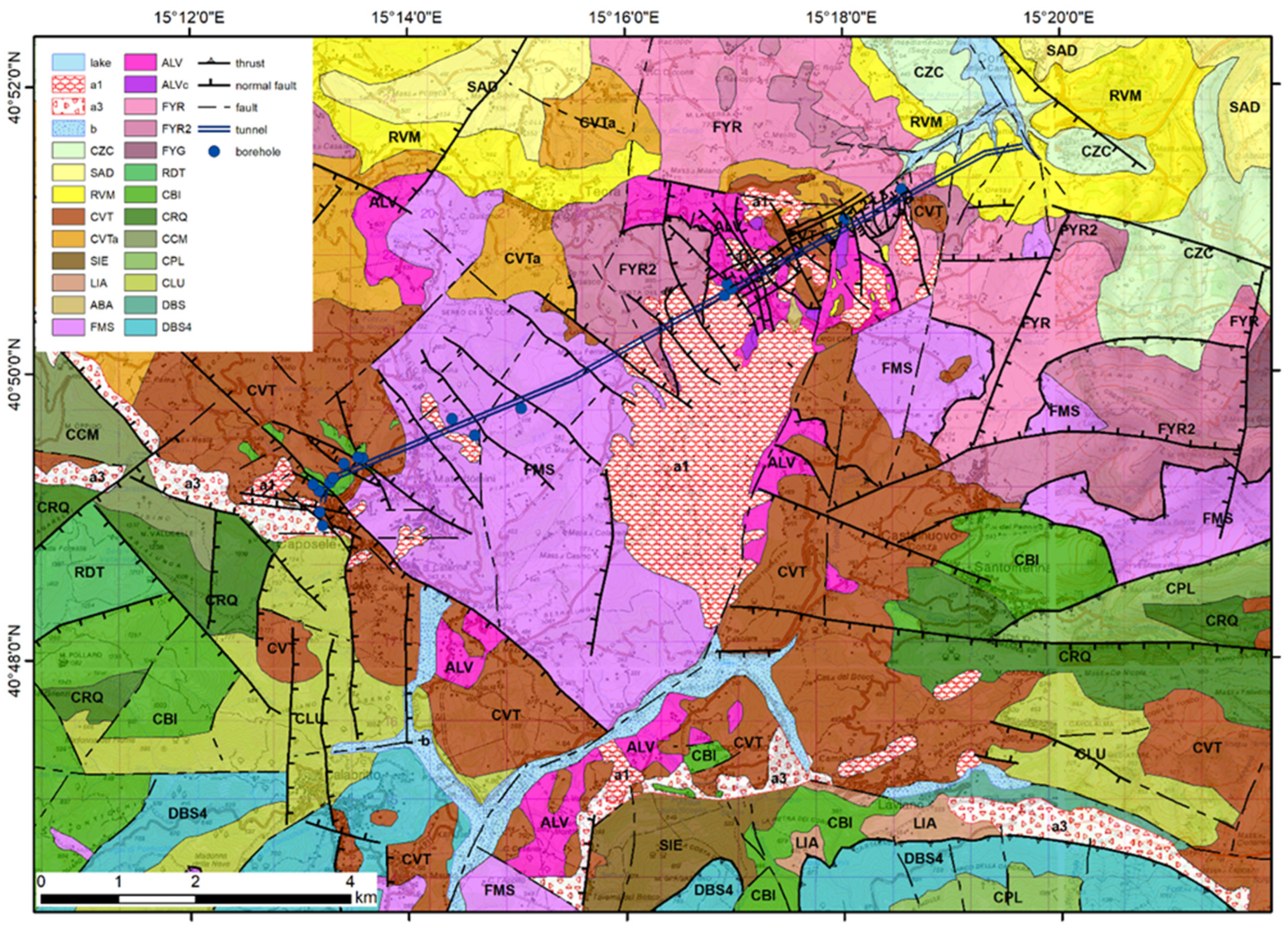
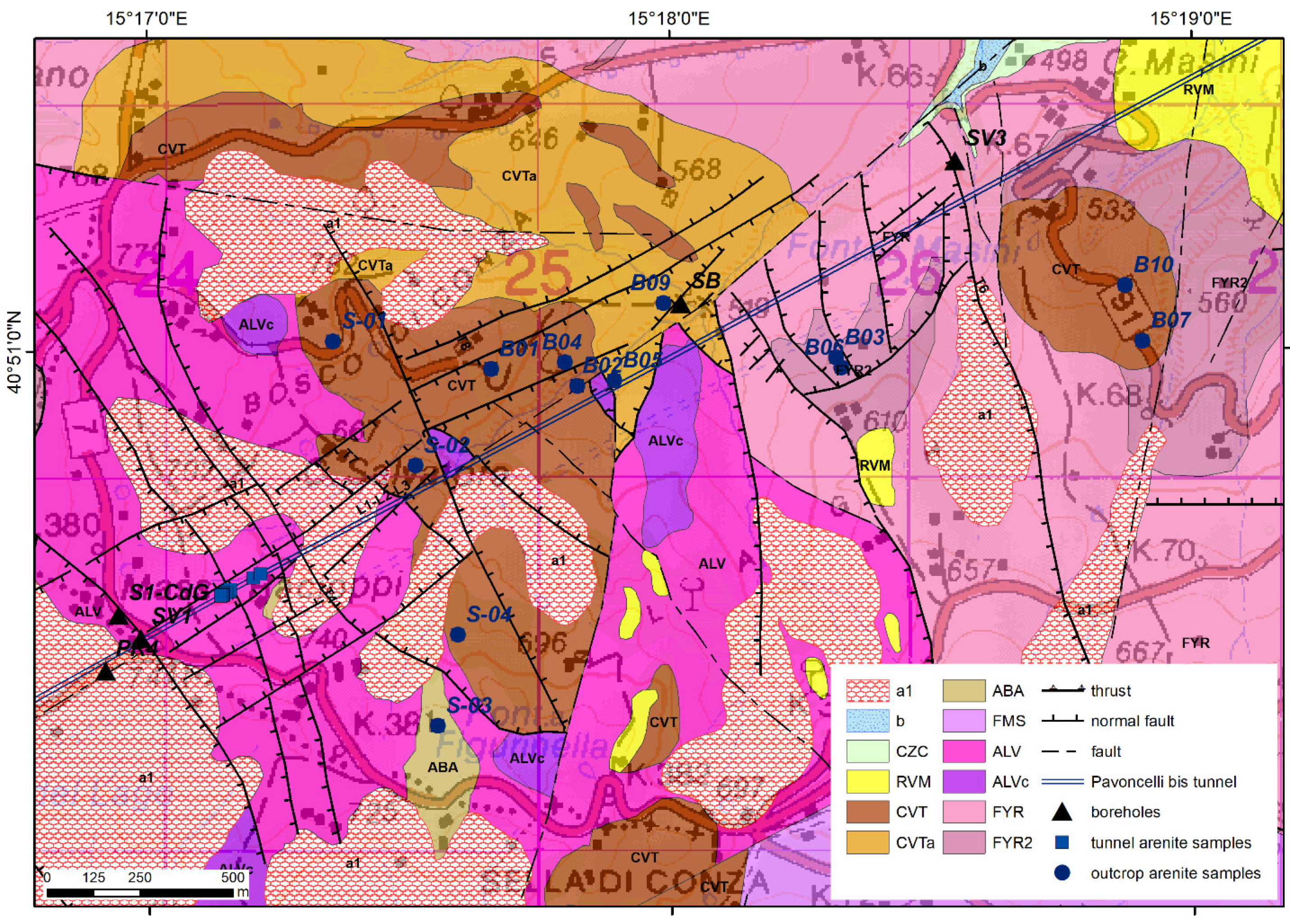
4.1. Geological Map: Stratigraphic Units and Structural Elements

The geological surveys performed in the study area allowed to recognize the presence of four main regional tectonic units (Figure 3), referred to different paleogeographic domains, such as the Sicilide unit (Lucanian basin), the Mt. Picentini and Mt. Marzano units (Apennine platform), and the Frigento unit (Lagonegro basin). These units are unconformably overlain by calciclastic and siliciclastic thrust-top basin and foredeep basin fillings, ranging from Early Miocene to Pliocene in age. Quaternary age deposits are mainly represented by debris slope talus, alluvial fan, and terraced and actual alluvial deposits.
The Sicilide Unit includes a Cretaceous to Oligocene-Early Miocene pelagic basin calcareous-pelitic succession, made up of pelitic deposits with a large component of carbonate resedimented deposits, forming the Argille Varicolori Superiori (ALV) and the Monte Sant’Arcangelo Fm. (FMS), belonging to the Argille Variegate Group (AV) [82]. They are overlain by siliciclastic, volcaniclastic, and calciclastic strata, referring to Corleto Arenite and Albanella Arenite (ABA) formations.
The Monte S. Arcangelo Fm. (FMS) is mainly formed by light brown, yellowish, greenish, and greyish marly limestones, sometimes silicified; subordinately, light brown and greyish graded and laminated calcarenites, dark clayey marls, thin bedded silty marls and micaceous arenites layers are present. The thickness is approximately 350–400 m. The unit is stratigraphically underlying and passing laterally into AVF. The age is referred to Eocene-Upper Oligocene [82].
The Argille Varicolori Superiori Fm. (ALV) is composed by greyish, greenish, and reddish clays interbedded with thin layered whitish limestones and marly limestones, related to a deep marine basin depositional environment. Locally, thin bedded reddish marls and calcareous marls, alternated with clayey marls, pinkish marls, fine grained greyish calcarenites with planar laminations, laminated clayey marls, silicized marls, and radiolarites with typical prismatic fractures are present. Some horizons up to 100 m thick are made of thick bedded whitish limestones, marly limestones and marls, whitish-greyish calcarenites, and calcilutites alternated with arenaceous-calcareous and calcareous-marly turbidites (calcareous lithofacies, ALVc). They are also formed by light gray, green, or reddish calcareous marls in medium layers with conchoid fracture, gray calcarenites with Tb-c Bouma sequences in thin to medium layers. The depositional environment is marine with turbiditic distal inputs. The unit stratigraphically overlies FMS, passes laterally and vertically into ABA. The thickness does not exceed 150 m. The age is Oligocene-Aquitanian [82].
A sequence formed by thin bedded brownish quartz-micaceous sandstones with planar and convolute laminations, poorly cemented yellowish and grey clayey marls, siltstones, blackish shales with calcite veins form the Albanella/Corleto unit (ABA), stratigraphically overlying the AV upper successions. The thickness is approximately 50–100 m. The age is Lower Miocene for the stratigraphic position.
The Apennine Platform units are formed by several lithostratigraphic units ranging in age between Noric and Late Maastrichtian. The lithological description, age and environment interpretation are derived by Torre et al. [82] and Pescatore and Pinto [83]. The sedimentary paleoenvironments of these carbonate successions can be referred to the margin of the carbonate platform, representing the lateral transition to the Lagonegro basin. Some differences in the stratigraphic succession between the Mt. Picentini and Mt. Marzano carbonate tectonic units are present.
The Mt. Picentini unit is Triassic to Lower Cretaceous in age in the lower portion, including several lithostratigraphic units of lagoonal succession, while the upper portion (Late Cretaceous) consists of bioclastic facies related to a high-energy open platform environment.
The Dolomia Superiore fm. (DBS) is formed by light grey layered dolostones, characterized by laminated stromatolites, alternated with massive dolostones. In the area, the Megalodon limestones and dolostones member (DBS4) is present, consisting of thin to thick layered grey limestones, dolomitic limestones (packstone, grainstone), and dolomites, with levels rich in megalodontids valves. The age is Norian–Hettangian p.p. and the depositional environment is peritidal. The total thickness exceeds 1000 m.
The Cladocoropsis and Clypeina limestone fm. (CCM) is formed by medium bedded grey and light brown mudstones, wackestones and packstones interbedded with thin bedded marls rich in Cladocoropsis mirabilis. In the upper part, limestones with dasycladacean algae (Clypeina sp.) are present. The age is Upper Jurassic–Neocomian and the environment is lagoonal. The thickness is at least 450 m.
The limestone and dolomitic limestone fm. (CLU) is formed by bedded light brown and grey oncolitic limestones of platform environment. The thickness is approximately 750 m. The age is Lower Jurassic p.p.–Neocomian.
The requienia and gasteropods limestone fm. (CRQ) is composed by light brown and grey layered limestones rich in nerineids and requienia, occasionally giving rise to bioclastic rudstones, alternated with mudstones and wackestones. Limestones with oolites, limestones with alveolinids, and laminated dolostones are also present. The total thickness is approximately 450 m, and the age is Barremian–Cenomanian p.p.
The Radiolitidae Limestone fm. (RDT) are formed by thick to medium strata of gray and white dolomitic limestone and limestone, and clastic limestone rich in rudists (Radiolitidae, Hippuritidae). The thickness is approximately 300 m. The age is Turonian–Campanian.
The bio-litoclastic rudist limestone fm. (CBI) is formed by massive bioclastic limestones (rudstones and floatstones) with abundant large fragments of rudists (radiolitids and hippuritids) and large gastropods and with thin beds of yellow-greenish marly limestones. A lithofacies with thick bedded “pseudosaccharoidal” limestones and graded calcarenites is present. The depositional environment is from open carbonate ramp to upper slope environment. The age is Upper Cenomanian–Paleocene. The thickness is approximately 300 m.
The Mt. Marzano unit crops out along the norther slope of Mt. Marzano massif and consists of the upper part of a discontinuous succession Upper Cretaceous–Lower-Middle Miocene in age, which is composed of the typical “pseudosaccharoidal limestones” units (CBI), made of calcirudites of open carbonate ramp and slope environments, disconformably overlain by the Laviano calcareous-pelitic sequence (LAI) and unconformably overlain by the Mt. Sierio calciclastic Fm. The lower part is formed by DBS, CLU, CRQ, and CPL units [82].
The Dolomia Superiore fm. (DBS) is formed by light colored, massive, and strongly fractured dolostones with stromatolites and bivalve shells, Norian–Hettangian p.p. in age, and about 100 m in thickness. The limestone and dolomitic limestone fm. (CLU) is composed by oncolitic light grey limestones, calcarenites, and light brown calcilutites with rare thin shells of small sized gasteropods. The thickness is approximately 400 m and the age is Lower Jurassic p.p.–Neocomian.
The requienia and gasteropods limestone fm. (CRQ) is formed by limestones rich in requienia, nerineids and other bivalve shells, and by oolitic and intraclasts limestones. The thickness is around 100 m; the age is Barremian–Cenomanian. The Palaeodasycladus limestone fm. (CPL) is made by micritic limestones characterized by peloids, oolites, and oncolites, and with Palaeodasycladus mediterraneus and Orbitopsella sp.; upwards calcareous-marly levels with spathized valves of Lithiotis sp. are locally present. The thickness is approximately 350 m; the age is Upper Hettangian-Pliensbachian.
The bio-litoclastic rudist limestone fm. (CBI) is formed by thick bedded or massive white limestones and calcirudites with abundant rudist fragments, often referred to the “pseudosaccharoidal limestones” lithofacies. The environment ranges from open carbonatic ramp to upper slope. The thickness is several hundreds of meters and the age is Upper Cretaceous-Paleocene.
The Laviano calcarenites fm. (LIA) is formed by a sequence comprising medium to thin layered laminated calcarenites and yellowish-greenish marly limestones, alternated with greyish-greenish marls and marly and silty shales. The basal part is characterized by thin bedded marly limestones and grey-greenish and pinkish marls about 5 m thick. The calcarenites locally contain an arenaceous fraction and quartz grains; upwards thin layered glauconitic bioclastic calcarenites alternated with calcilutites, marls, and whitish calcareous marls, and rare “numidian” quartzarenites are found. The thickness is approximately 100 m. The strata are formed by turbidites related to basin-slope toe, and hemipelagic deposits. The unit overlies in paraconformity on CBI. The age is Serravallian–Lower Tortonian [82].
The Monte Sierio Fm. (SIE) unconformably overlies on CBI. It is formed by calcirudites and calcarenites rich in nummulites and alveolines bioclasts; locally upwards, marly calcilutites, laminated and silicized siltstones, laminated lithic sandstones, calcarenites with nummulites and orbitoids, and blocks and strata composed of “numidian” sandstones are present. The thickness is not less than 150 m and the age is Upper Tortonian.
In the study area, the Frigento Unit consists mainly of Cretaceous to Early Miocene basinal and shelf-margin facies successions (Flysch Galestrino Fm. and Flysch Rosso Fm.), characterized by calcareous clastic and pelitic turbidite associations laterally and vertically passing to marly-calcareous successions; a debris calcareous clastic lithofacies is present at different heights. The Flysch Rosso Fm. pass gradually upward to the upper Burdigalian-upper Langhian p.p. Numidian Flysch with alternations of calcarenites, marls, and quartzarenites.
The Flysch Galestrino Fm. (FYG) is formed by grey-green medium to thick bedded siliciferous marls and clays with intercalations of medium-thin bedded silicified calcarenites and calcilutites of dark grey color; dark grey siliceous shales with intercalations of grey calcilutite in layers up to 30 cm thick are also present. The unit crops out discontinuously with thicknesses around a few tens of meters. It is referred to a bathyal environment with both siliciclastic and carbonate turbiditic inputs. The age is Upper Jurassic p.p.–Cretaceous.
The Flysch Rosso Fm. (FYR) is formed by red and grey-green marls and clays, thin bedded calcilutites, medium bedded commonly graded and laminated calcarenites with Alveolinidae, Nummulites, and Orbitoids, thick bedded litoclastic calcirudites with rudist fragments. The limestone member (FYR2) is formed by grayish and white clastic limestone (calcirudites, crystalline limestone, breccias, calcarenites) in thick and very thick massive layers, with irregular stratification and internal amalgamation, resting with erosive contact on grayish clayey-marly horizons cleavage fractures. In the upper part of the formation, a “pre-numidian sequence,” showing the gradual transition to FYN, is formed by grey-green silty clays with intercalations of medium to thick bedded yellowish calcarenites rich in quartz granules. The environment is pelagic ranging from bathyal to carbonate slope toe. The thickness is approximately 200 m. The age is Late Cretaceous p.p.–Early Miocene p.p.
The turbiditic, grain-flow and hemipelagic siliciclastic deposits of the Castelvetere Formation (CVT) and the clastic Pliocene units (SAD and RVM) present an unconformable lower boundary overlying the deformed Sicilide, Mt. Picentini, Mt. Marzano, and Frigento units. The Castelvetere Fm. (CVT) is formed by arenites and granular conglomerates in thick beds with lens-shaped geometry and erosive base, locally amalgamated, containing clay-chips and thin pelitic interlayers, locally reddish and rich in coal fragments, and by quartz-feldspathic arenaceous turbidites and paraconglomerates. The thickness is approximately 250 m. The silty-clayey-marly lithofacies (CVTa) is formed by yellowish quartz-micaceous arenaceous siltstones in thin beds with planar and convolute laminations within bedded clays and grey-green silty marls. The thickness is approximately 150 m. The basal coarse sequences are composed of channeled facies rich in detrital deposits (olistolites) and clayey landslides (olistostromes) that are present at different stratigraphic levels. The upper finer sequence is linked to a turbidite system formed by depositional lobes and overbank deposits. The age is Upper Tortonian–Lower Messinian.
There are two Pliocene units, the Andretta Synthem (SAD) and the Ruvo del Monte Synthem (RVM). The Andretta Synthem (SAD) is formed by continental fan-delta conglomeratic and sandy deposits passing to coastal marine sands and clays. On the northern slope of the Ofanto river valley, the sequence is formed by yellowish silty-marly clays, locally interlayered with fine-grained sands and thin arenite beds. The thickness is of about 150 m, and the age is referred to the Early Pliocene (biozone MPl3/MPl4a).
The Ruvo del Monte Synthem (RVM) is approximately 200 m thick and Early–Middle Pliocene in age (biozone MPl4a); it consists mainly of arenitic-sandy-conglomeratic deposits from paralic to continental environment. The synthem is formed of a fine to medium-grained sandy succession, containing current structures and fragments of shells and valves of ostreids and pectinids, and locally with well-cemented arenitic lenses. Very thick layers and lenses of conglomerates with intercalations of lithic coarse sand and micro-conglomerates with a reddish yellow sandy matrix are also present.
Among the Quaternary units, the Conza della Campania synthem (CZC) crops out with terraced fluvial deposits along the Ofanto river and around the Conza lake. Usually, the succession is formed by gravel lens, pale yellow sands, silts, and gray to brown clayey silts, and is 10 m thick. The age is referred to Middle Pleistocene–Holocene.
More recent deposits linked to the active geomorphic processes are mainly represented by debris slope talus (a3), terraced and actual alluvial deposits and alluvial fan (b), and landslide deposits (a1).
The studied area is characterized by two structurally complex carbonate blocks, forming the morpho-structural heights of the Picentini Mts. to the west and the Mt. Marzano massif to the east (Figure 4). They are separated by the large tectonic depression of the Sele river valley, bounded by roughly N-S trending structural lineaments, and are interrupted northward by the wide E-W trending tectonic depression of the Ofanto river valley developing along transversal active seismo-tectonic structures.
The described tectonic units are strongly deformed by mainly east-verging imbrications and are unconformably covered by Burdigalian to Tortonian sequences. The imbrications are formed by folds related to reverse faults located into north-east verging regional thrust sheets. The tectonic superpositions are complicated by a polyphase structuration, which occurred during the deposition of Late Miocene to Pliocene siliciclastic synorogenic deposits [84]. The morpho-structural setting of the area is controlled by the Plio-Quaternary extensional tectonics, which uplifted the two major carbonate massifs and led to the formation of the Sele and Ofanto river valleys.
The internal Sicilide units tectonically overly the platform carbonate units, and largely crop out only in the tectonic depressions within the Sele and the Ofanto valleys. Only small scattered remains of the Sicilide stratigraphic succession can be found on the carbonate massif slopes. The carbonate platform units tectonically overly the Frigento unit, and these thrusting structures are probably linked to those observed in the central Picentini area within the Campagna tectonic window [27]. In our study area, these structures are hidden by Quaternary high-angle normal faults bordering the Ofanto River valley tectonic depression. In fact, along the northern mountain front of Picentini and Marzano Massifs, a peculiar structural setting, characterizing the entire southern Apennines axial belt, is well evident. The regional overthrusting of the carbonate platform units onto the Lagonegro units is characterized by a late reimbrication of the older thrust sheets [82]. The reimbrication crops out south of Laviano, where the Triassic carbonate units (Mt. Picentini unit) thrusted over the “pseudosaccharoidal limestones” and detrital limestones related to the Mt. Marzano unit covered by the Laviano sequence. This reimbrication also involve the tectonic overlapping of the Mt. Marzano unit on Sicilide unit and Frigento unit thrusts.
The border between the Picentini Mts. massif and the Sele valley is bounded by a lateral hanging-wall ramp of the reimbrication thrusts, locally characterized by sub-vertical reverse faults and by a large antiformal fold, with NNE oriented axis parallel to the massif border [82]. The western flank of the Sele valley tectonic depression is defined by this regional fold and associated to later NNE trending high angle normal faults. Indeed, the eastern flank of the Sele valley is essentially controlled by faults produced by mainly SSE and ESE-trending faults with a generally oblique kinematics. Southward the study area, some large carbonate bedrock blocks, bounded by the same transtensional tectonics, crop out also within the valley (see for example Oliveto Citra, Contursi, and Quaglietta carbonate blocks [82]).

4.2. Subsurface Data: Tunnel and Borehole Logs

The subsurface geological data were collected along the tunnel underground line by lithological analyses of the excavated spoil materials, integrated by petrological analyses of rock samples collected along the tunnel excavation surfaces and by detailed stratigraphic and structural surveys made in key sections during some technical stops of the excavation works.
The tunnel crosses three main sectors characterized by very different lithological features (Table 1) separated by first-order tectonic structures. The western sector of the tunnel, from 0 to 655 m, was excavated within massive and fractured carbonate successions belonging to the CBI unit. The central sector of the tunnel, from 655 to 7760 m, was characterized by complex and strongly tectonized lithological units ranging from calcareous-pelitic to arenaceous rocks (FMS, ALV, ABA, CVT). In this sector, based on the lithological description of the excavated spoil materials, some different lithofacies have been recognized within the succession of the FMS unit: FMS-arg (argillaceous lithofacies), FMS-arg-ma (argillaceous-marly lithofacies), FMS-ma-arg (marly-argillaceous lithofacies), and FMS-cal-ma (calcareous-marly lithofacies). Arenitic strata were firstly found at 6100 m nearby a complex fault system. The eastern sector of the tunnel, from 7760 to 8500 m, was excavated in well stratified argillite, marl, and calcarenite sequences (FYR unit), and then up to 10,220 m in Pliocene deposits.
A technical stop during the TBM excavation works allowed to perform detailed stratigraphic and structural surveys along the walls of a small lateral tunnel between 6170–6190 m.
A fining-upward pelitic-arenitic stratified sequence, about 15 m thick, has been recognized (Figure 5). The strata are tilted toward the west, where the initial sector of the tunnel is located; the dipping is usually N240–20° (dip direction-dip angle). It is formed by coarse to medium-grained arenites thick strata with thin layers of dark silt and clays passing to fine grained arenites, dark gray siltstones and argillites thin strata. The thick arenitic strata (20–60 cm) show normal grading structures passing to parallel and cross laminations in the fine-grained arenitic and silty layers (5–20 cm in thickness); in the upper part of the stratigraphic sequence, a pebbly mudstone layer is present.
The rock mass is locally heavily jointed due to several fault systems crossing the bedding. A fault plain, oriented N300–75° with a 10–15 cm thick shear zone, cuts and dislocates the sequence near chainage 6175 m (Figure 6).
The analysis of the stratigraphic logs of n. 17 boreholes (Table 2), extending from 40 m to 350 m in depth, allowed to link the geological units recognized along the tunnel profile to the underground and surface geological units. The boreholes NP1, NP2, NP5, NP6, NP7, NP8, PR1, PB1, and PB2, located in the western sector of the Pavoncelli bis tunnel between Caposele and Materdomini towns (Figure 7), show the thickness variation (in the range of 11 to 120 m) of CVT pelitic-arenaceous sequences laying on the CBI calcareous substratum. Instead, the PR1 borehole show the tectonic superposition of FMS unit on CBI carbonate unit that is sutured by the CVT sequence.
The boreholes PR2, PR3, PR4, S1-CdG, SV1, and SV2, located in the median sector of the Pavoncelli bis tunnel around Cresta del Gallo and Bosco di Contra localities (Figure 7 and Figure 8), show the relationships between FMS and ALV units, while the SV3 and SB boreholes, located in the easternmost tunnel sector (Figure 8), show the stratigraphy details of FYR and CVTa units.

4.3. Sandstone Petrology: Principal Compositional Groupings

Sandstone composition analysis includes 21 sandstone samples. Samples have been collected both along stratigraphic sections cropping out in the area located in correspondence with the tunnel segment comprised within 6000–8600 m chainage interval (Figure 8), and in some tunnel sections between chainage 6100 m and 6300 m (Figure 9).
Table 3 summarizes the raw data of point-counting results of selected sandstones, while Table 4 shows recalculated grain parameters. The analyzed sandstone samples include 6 quartzolithic sandstone of the Albanella-Corleto Formation (ABA), 12 quartzofeldspathic sandstones of the Castelvetere Formation (CVT), and 3 quartzose and hybrid arenites of the pre-Numidian interval of FYR upper part (Figure 10 and Figure 11).

4.3.1. Quartzolithic Sandstone Petrofacies

The petrofacies has abundant quartz and lithic grains (Qm60 F13 Lt26), while feldspar is minor and dominantly plagioclase. Aphanitic lithic fragments (Lm42 Lv31 Ls27) include metavolcanic (serpentinite, Figure 10a to serpentine schist), volcanic (mainly microlithic, Figure 10b and felsitic textures), abundant metasedimentary (phyllite, schist, minor quartzite, and fine-grained schist; Figure 10c–e), and sedimentary (micritic to sparitic limestone grains, and radiolarian chert) grains. The abundant metasedimentary fragments in this petrofacies are derived from the low-to-medium grade metamorphic Paleozoic sections of the Calabrian Terranes [25,33,34,36,37,39,40]. The abundant volcanic lithic fragments are derived from coeval active volcanism located to the west (i.e., Sardinia magmatic arc; [25]) and textures of the volcanic particles suggest an andesitic to dacitic volcanism [68]. Metavolcanic fragments are closely related to accreted oceanic terranes of the Lucanian Oceanic Unit obducted at the time of deposition of the Quartzolithic sandstones of the Corleto Formation [25,31]. Sedimentary detritus can have diverse source terranes from the Mesozoic sedimentary covers of the Paleozoic metamorphic units, and from sedimentary strata of the accreted oceanic terranes, and from the basinal and carbonate platform units of the internal portions of the Apenninic units [25,33,35,36]. The quartzolithic petrofacies corresponds to the Corleto and Albanella Sandstone Formations (Figure 11).

4.3.2. Quartzofeldspathic Sandstone Petrofacies

The petrofacies has abundant quartz and feldspars (Qm51 F32 Lt15), while lithic fragments are minor. Plagioclase grains are dominant than K-feldspar (P/F = 0.83). Aphanitic lithic grains include abundant metasedimentary and sedimentary, minor volcanic, and ophiolite lithic particles (Lm47Lv7 Ls46). Metasedimentary lithic fragments include abundant phyllite and fine-grained schist. Sedimentary lithic fragments consist of abundant extrabasinal carbonate fragments, mostly Jurassic to Lower Tertiary pelagic and shallow-marine carbonate fragments and minor radiolarian chert, shale, and siltstone fragments. Ophiolitic detritus includes serpentinite and serpentine-schist, whereas volcanic lithic fragments are minor and consist of lithic particles that have a felsitic granular texture. Phaneritic rock fragments (apportioned in Qm, P, K, micas, and dense minerals [69,78,85]) include plutonic and metamorphic detritus; plutonic detritus consists of dominantly quartz-plagioclase-biotite particles of granodioritic to tonalitic compositions (Figure 10g,h), and minor quartz-K-feldspar composite grains of granite composition. Phaneritic metamorphic detritus consists of quartz-plagioclase-sillimanite, and quartz-plagioclase-garnet-sillimanite composite grains of gneiss and micaschist.
The abundant metamorphic and plutonic detritus in the quartzofeldspathic sandstone petrofacies are derived from the metamorphic and plutonic Paleozoic sections of the Calabrian Terranes [25,33,34,36,37,39,40]. Sedimentary detritus can have diverse source terranes from the Mesozoic sedimentary covers of the Paleozoic metamorphic-plutonic terranes, and from sedimentary strata of the basinal and carbonate platform units of the internal portions of the Apenninic units [25,33,35,36]. Ophiolitic fragments are closely related to thrusted oceanic terranes of the Lucanian Oceanic Unit [25,31]. The quartzofeldspathic petrofacies corresponds to the Castelvetere Sandstone Formation (Figure 11).

4.3.3. Hybrid Arenite and Quartzarenite Sandstone Petrofacies

This composite petrofacies has abundant quartz (Qm95 F5 Lt0), while feldspar is minor and dominantly plagioclase. Aphanitic lithic fragments are virtually absent or minor. Quartz grains are dominantly monocrystalline, and they are well rounded. Few dense minerals are ultrastable and consist of zircon, tourmaline, and rutile. Quartzarenite are well cemented by quartz overgrowth and calcite. Hybrid arenites of the pre-Numidian Sandstone Formation include abundant quartz, and extrabasinal carbonate lithic grains. Very abundant intrabasinal carbonate particles of bioclasts (Figure 10f, mainly planktonic forams and sponges), and minor peloids and intrabasinal non-carbonate glauconite grains. Abundance of well-rounded quartzose detritus of the pre-Numidian and Numidian Sandstone Formation has been interpreted as a craton-derived huge arrivals of sand-sized quartz from the African continental margin [25,33,37,38,86,87]. The quartzose and hybrid arenite petrofacies corresponds to the pre-Numidian (hybrid arenite) and Numidian Sandstone Formation (quartzarenite) (Figure 11).

5. Discussion

5.1. Geological Profile along Tunnel Pavoncelli Bis

All data obtained by the geological surveys performed on the field in the study area and the subsurface geological data derived by the tunnel excavations and the boreholes, integrated by petrological analyses of arenitic samples, allowed to obtain a detailed geological profile along the tunnel Pavoncelli bis track. The geological profile (Figure 12a) shows complex stratigraphic structures and tectonic patterns and three main different structural sectors can be recognized.
In the western sectors, located between Caposele springs and chainage 655 m of the tunnel (Figure 12a), a Late Cretaceous formation (CBI fm.) belonging to the Mt. Lattari carbonate tectonic unit is unconformably covered by the Late Miocene arenaceous-clayey successions (CVT Fm.). The stratigraphic sequence is faulted with horst and graben structures originated by Quaternary NW-SE trending normal faults.
The large central sector is showed in the geological profile encompasses from chainages 655 m to 7700 m, and it is characterized by the presence of complex structures involving mainly the Sicilide Unit. In the initial part, ranging from 665 m to 5400 m (Figure 12a), different lithofacies of the Monte Sant’Arcangelo Fm. (FMS) are present and are locally covered by the unconformable deposits of the Castelvetere Fm. (CVT). The stratigraphic succession if strongly folded and faulted by normal faults, NW-SE, NE-SW, and N-S trending. The NW-SE oriented set is formed by high-angle normal faults, dipping toward SE up to the chainage 4200 m and toward NW after that sector. This change in the tectonic pattern allows to observe the back-thrusting of the Frigento Unit (Lagonegro basin) onto the Sicilide Unit in the Cresta del Gallo area, corresponding to the tunnel interval ranging from 4200 m and 5400 m. In fact, in this area an approximately 150 m thick calcareous-clastic sequence of the calcareous member (FYR2) of the Flysch Rosso Fm. forms a small calcareous ridge tectonically laying over the calcareous-pelitic poly-folded sequences of the Monte Sant’Arcangelo Fm. (FMS), recognized along the tunnel. The thrust surface is cut off by NE-dipping high angle normal faults; in this sector, the large and complex Buoninventre landslide [88] was reactivated after the 1980 earthquake and is still partly active. In the final part of this central sector, between 5400 m and 7760 m (Figure 12a), the tectonic structures are more complex. Two thrusting surfaces, crossing the tunnel at about 5400 m and 6200 m, involve the whole stratigraphic succession of the Sicilide Unit. The first thrust fault is characterized by a folded strata sequence of FMS and ALV units in the hanging-wall and a sequence of ALV and ABA units in the foot-wall, where a minor reverse fault separates the ALV and ABA units. This thrust plane is cut and displaced by two sub-vertical normal faults at 5900 m and 6100 m and is interrupted by a major normal fault at 6200 m. The Early Miocene arenite (ABA) strata, about 100 m thick, are entrapped within these normal faults at the tunnel depth. The latter fault divides the described tectonic structure by a different structural sub-sector, characterized by the thrusting of a folded strata sequence of FMS, ALV, and CVT units (hanging-wall) onto a sequence of ALV and CVT units (foot-wall). Thick sequence (200–300 m) of Late Miocene arenites (CVT) characterizes this area. Several normal faults cut the stratigraphic succession and further dislocate the thrust plane.
The eastern sector of the geological profile encompasses from chainage 7700 m to 10,220 m (Figure 12a) and is characterized by more simple tectonic structures and completely different stratigraphic units. An important normal fault cut the thrust surface of the Frigento unit onto the Sicilide unit, crossed by the tunnel at 7800 m. The Frigento unit is formed by the thick argillaceous-calcareous sequence of the Flysch Rosso Fm. (FYR, FYR2), comprising pre-numidian strata in the uppermost part. Several high-angle normal faults, mainly NNW-SSE oriented, have originated horst and graben structures. At about 8925 m, the unconformity basal contact of the Pliocene stratigraphic sequences (RVM synthem) on the Frigento unit is preserved. The RVM sandy-silty succession is little deformed.

5.2. Geology and Tectonic Evolution

The studied region is located at the intersection of the Irpinia, Sele Valley, and Lucania sectors in the axial-eastern margin of the Southern Apennines (Figure 1). This sector represents a key area for understanding the paleogeographic and tectonic evolution. Trias to Early Miocene basin to slope successions and Middle Miocene to Pliocene foreland clastic successions widely occur. The pre-orogenic successions are arranged into several regional tectonic units, such as the Sicilide, Picentini Mt., Marzano Mt., and Frigento units [27,84,90]. The Sicilide Unit consists of basinal facies ranging in age from Late Cretaceous to Early Miocene; the unit overthrusts both Picentini Mts. Unit and Frigento Unit. The Picentini Mts. Unit is a fragment of the Southern Apenninic platform (namely “Campano-Lucana” platform) and is formed by pre-orogenic carbonate platform successions ranging from Late Jurassic to Paleogene; it is tectonically lying on the Frigento Unit. The Mt. Marzano unit is formed by upper Trias-Langhian pre-orogenic carbonate platform to slope successions, followed by Serravallian foredeep deposits (Laviano sequence. LAI). The Frigento Unit [27] includes lower Cretaceous shales with resedimented limestones (Flysch Galestrino) and Upper Cretaceous–Lower Miocene succession of hemipelagic mudstones and with resedimented limestones (i.e., ‘Flysch Rosso’ Fm.), conformably overlain by Numidian quartzarenites. These tectonic units are unconformable overlain by thrust-top basin and foredeep basin fillings of mixed to siliciclastic successions, ranging from Early Miocene to Pliocene in age (ABA, SIE, CVT, RVM). These successions are separated by regional unconformities [27].
The described units are strongly deformed and thrusted eastward, with minor westward back-thrust structures, and testify a poly-phase orogenic evolution during Early Miocene, Middle–Late Miocene, and latest Miocene–Pliocene times. These phases are characterized by the subduction of the oceanic crust along the Adria margin producing an accretionary prism during Paleogene–Early Miocene, Adria lithospheric flexing and tectonic contraction of Meso-Cenozoic platforms and basins during Tortonian and Messinian and by the reimbrication, thrusting, and refolding of older thrust-sheets [27,33,84].
During Early Miocene tectonic phases, the final closure of the southern and eastern Tethyan realm and onset of accretionary processes of the Mesomediterranean microplate (e.g., Calabrian Terranes [25]) is responsible of huge volumes of clastic sedimentary sequences, dominantly deep-marine turbidite systems, which were deposited at the front of the accretionary orogenic terranes in foreland basin systems [25]. The latest Oligocene-to earliest Miocene correspond with the final closure of the Lucanian Oceanic realm, where sandstone turbidite successions having dominantly a quartzolithic composition (i.e., Corleto sandstone Formation), interbedded with volcanolithic sandstones (i.e., Tufiti di Tusa Formation), were accommodated. After deformation of the oceanic terranes, at the end of Burdigalian, the Langhian to Tortonian foreland sequences unconformably covered the oceanic units and correspond with deposition of the Cilento Group.
The Tortonian phase was characterized by a north-east direction of the tectonic transport, causing the sequential superimposition of the Sicilide Unit onto the Apennine Platform units and of these units on the Frigento Unit. The phase produced geometric relationships of hanginwall-flat on footwall-flat type [27]. These thrusts are suturated by the Late Tortonian–Early Messinian Castelvetere Formation. This latter unit, a sand-rich turbidite system, has dominantly quartzofeldspathic sandstones, which has an abundance of coarse grained plutonic and high-grade metamorphic phaneritic rock fragments, derived from weathered [25,33,81,91] highest tectonic units of the northern Calabrian terranes.
During Early Messinian–Middle Pliocene, a stage of collisional tectonics with sequential effects of break-back-thrust type developed [27]. During the Early-Late Messinian phase, new geometric relationships of the previously assembled units were produced by out of sequence thrusting structures (breaching, [43]), which were sutured by the Late Messinian successions (Altavilla unit and Anzano Molasse Fm. [23]). The Early–Middle Pliocene phase was characterized by the development of severe rearrangements within the orogenic wedge. Since Early Pliocene, the breaching effects determined high angle faults, namely fault cut-off, involving the older faults within the tectonic wedge [27]. A back-regressive evolution of the fault cut-off from the current marginal areas to that internal to the chain (from east to west) occurred at regional scale. Middle Pliocene unit (Ruvo del Monte Synthem) sutured the fault cut-off in the Ofanto river valley. This tectonic evolution can be attributed to the structuring processes of the buried Apulian Unit as recorded in the more external Irpinia sector [92,93]. The uplift generated by the buried duplexing of the Apulian continental crust blocked the sequential kinematics progression towards the Adriatic sectors. The resistance to progression, during Africa-Adria plates convergence, generated surface dislocations towards the Tyrrhenian due to a gravity processes of re-adjustments in the tectonic wedge behind the outer edge, causing the back-thrusting of the Lagonegro unit onto the Sicilide unit [27].
The regional geological section (Figure 12b) shows the relationships among assembled tectonic units, Quaternary normal faults and 1980 seismic faults. The studied axial areas of southern Apennines are also characterized by high heat flux data suggesting the presence of melt intruded into the crust along lithospheric faults in the zone [94,95]. A relationship between the geodynamic evolution, the melt intrusions, and the genesis of the large earthquakes in the region is suggested [94].
The few volcanic rocks found close to the 1980 epicentral area are those of Tertiary age crossed by deep oil drillings [28], and the allochthonous diabase within Sicilide unit cropping out near Frigento [92,93,95], but there is no evidence of relation between these magmatic rocks and the analyzed volcaniclastic rocks.

6. Conclusions

The geological study carried out in the southern Apennine divide area, where the new Caposele-Conza hydraulic tunnel called Pavoncelli bis was built, allowed to obtain relevant new elements on the tectonic and stratigraphic evolution of the Apennine thrust belt.
The excavation of the Pavoncelli bis gallery has given us a new opportunity for obtaining a detailed knowledge of the geological structures that are present in the subsurface of the studied sector of the Apennine chain, where the tectonic events have almost completely hidden the original geometric relationships existing between the various geological units. The complexity of the geological structures and the mainly pelitic nature of the lithologies here present made the reconstruction of the geological structures crossed by the excavation very difficult, especially in correspondence with the tunnel sections with high thickness coverage. However, the collection of original subsoil data and the results of detailed geological surveys, supported by in-depth analysis of the petrographic characteristics of the arenitic successions, allowed to elaborate a geological detailed model of the area crossed by the tunnel excavations, which has been reported in the geological profile (Figure 12).
For the first time for this area, the presence of quartzolithic arenaceous successions with volcanoclastic composition, related to the Early Miocene arenaceous successions of the Corleto/Albanella Sandstone Formations, and a quartz-feldspathic arenaceous successions, related to the late Miocene Castelvetere Formation, have been documented in an exhaustive way both in the outcrops and in the tunnel sectors.
The stratigraphic and petrological data allowed to recognize the presence in the study area of the arenitic sequence of quartzolithic petrofacies corresponding to the lower Miocene Corleto/Albanella Sandstone Formation. These units usually unconformably cover the Argille Varicolori Superiori Fm., typical of the upper part of the Sicilide Unit, and were originally deposited in the Lucanian basin. These data may allow conforming the presence of the Sicilide unit in the axial sector of the Campania mountain belt eastward to the Apennine carbonate units.

Author Contributions

Methodology, S.d.N., F.M., and S.C. (Salvatore Critelli); petrological analysis, S.C. (Sara Criniti) and S.C. (Salvatore Critelli); field investigation, S.d.N. and F.M.; writing, F.M. and S.C. (Salvatore Critelli); project administration, S.d.N. All authors have read and agreed to the published version of the manuscript.

Funding

This research received no external funding.

Acknowledgments

We acknowledge the support given in the field surveys by geol. Antonio Riviello, and in the tunnel surveys by Eng. Roberto De Angelis. We also acknowledge for the technical support (access to excavated rock and soil sample, assistance during tunnel visits, and logistic support) given by Caposele scarl.

Conflicts of Interest

The authors declare no conflict of interest.

References

  1. Guidoboni, E.; Ferrari, G.; Mariotti, D.; Comastri, A.; Tarabusi, G.; Sgattoni, G.; Valensise, G. CFTI5Med, Catalogo dei Forti Terremoti in Italia (461 a.C.-1997) e nell’area Mediterranea (760 a.C.-1500); Istituto Nazionale di Geofisica e Vulcanologia: Roma, Italy, 2018; Available online: storing.ingv.it/cfti/cfti5/ (accessed on 18 June 2020).
  2. Locati, M.; Camassi, R.; Rovida, A.; Ercolani, E.; Bernardini, F.; Castelli, V.; Caracciolo, C.H.; Tertulliani, A.; Rossi, A.; Azzaro, R.; et al. Database Macrosismico Italiano (DBMI15), versione 2.0; Istituto Nazionale di Geofisica e Vulcanologia: Roma, Italy, 2019; Available online: emidius.mi.ingv.it/CPTI15-DBMI15/description_DBMI15.htm (accessed on 18 June 2020).
  3. Branno, A.; Esposito, E.; Luongo, G.; Marturano, A.; Porfido, S.; Rinaldis, V. The largest earthquakes of the Apennines, southern Italy. In Proceedings of the AIGI-IAEG Proceedings, Bari, Italy, 13–19 April 1986; Volume 4, pp. 3–14. [Google Scholar]
  4. Bernard, P.; Zollo, A. The Irpinia (Italy) 1980 earthquake: Detailed analysis of a complex normal faulting. J. Geophys. Res. 1989, 94, 1631–1648. [Google Scholar] [CrossRef]
  5. Valensise, G. Summary of Contributions on the 23 November 1980, Irpinia earthquake. Ann. di Geofis. 1993, 36, 345–351. [Google Scholar]
  6. Westaway, R.W.C.; Jackson, J.A. Surface faulting in the southern Italian Campania—Basilicata earthquake of 23 November 1980. Nature 1984, 312, 436–438. [Google Scholar] [CrossRef]
  7. Pingue, F.; De Natale, G. Fault mechanism of the 40 seconds subevent of the 1980 Irpinia (Southern Italy) earthquake from levelling data. Geophys. Res. Lett. 1993, 20, 911–914. [Google Scholar] [CrossRef]
  8. Porfido, S.; Alessio, G.; Gaudiosi, G.; Nappi, R.; Spiga, E. The resilience of some villages 36 years after the Irpinia-Basilicata (Southern Italy) 1980 earthquake. In Proc. 4th WLF2017, Advancing Culture of Living with Landslides; Mikošet, M., Casagli, N., Yin, Y., Sassa, K., Eds.; Springer: Cham, Switzerland, 2017; Volume 15. [Google Scholar]
  9. Cotecchia, V. Ground deformations and slope instability produced by the earthquake of 23 November 1980 in Campania and Basilicata. Geol. Appl. Idrogeol. 1986, 21, 31–100. [Google Scholar]
  10. Cotecchia, V.; Salvemini, A.; Ventrella, N.A. Interpretazione degli abbassamenti territoriali indotti dal terremoto del 23 Novembre 1980 e correlazioni con i danni osservati su talune strutture ingegneristiche dell’area epicentrale irpina. Riv. Ital. Geotec. 1990, 4, 145–158. [Google Scholar]
  11. Esposito, E.; Pece, R.; Porfido, S.; Tranfaglia, G. Hydrological anomalies connected to earthquakes in Southern Apennines (Italy). Nat. Hazards Earth Syst. Sci. 2001, 1, 137–144. [Google Scholar] [CrossRef] [Green Version]
  12. Porfido, S.; Esposito, E.; Michetti, A.M.; Blumetti, A.M.; Vittori, E.; Tranfaglia, G.; Guerrieri, L.; Ferreli, L.; Serva, L. Areal distribution of ground effects induced by strong earthquakes in the Southern Apennines (Italy). Surv. Geophys. 2002, 23, 529–562. [Google Scholar] [CrossRef]
  13. Gizzi, F.T.; Potenza, M.R.; Zotta, C. 23 November 1980 Irpinia–Basilicata earthquake (Southern Italy): Towards a full knowledge of the seismic effects. Bull. Earthq. Eng. 2012, 10, 1109–1131. [Google Scholar] [CrossRef]
  14. Galli, P.; Peronace, E. New paleoseismic data from the Irpinia fault. A different seismogenic perspective for southern Apennines (Italy). Earth Sci. Rev. 2014, 136, 175–201. [Google Scholar] [CrossRef]
  15. Galli, P.A.; Peronace, E.; Quadrio, B.; Esposito, G. Earthquake fingerprints along fault scarps: A case study of the Irpinia 1980 earthquake fault (southern Apennines). Geomorphology 2014, 206, 97–106. [Google Scholar] [CrossRef]
  16. Engineering Office. The Apulian Acqueduct, Southern Italy. Engineering 1929, 35–36. [Google Scholar]
  17. Servizio Geologico d’Italia. Carta Geologica d’Italia alla Scala 1:100.000, F° 186 «S. Angelo dè Lombardi», 1st ed.; Servizio Geologico d’Italia: Roma, Italy, 1970; Available online: http://193.206.192.231/carta_geologica_italia/tavoletta.php?foglio=186 (accessed on 9 May 2020).
  18. Servizio Geologico d’Italia. Carta Geologica d’Italia alla Scala 1:100.000, F° 198 «Eboli»; Servizio Geologico d’Italia: Roma, Italy, 1970; Available online: http://193.206.192.231/carta_geologica_italia/tavoletta.php?foglio=198 (accessed on 9 May 2020).
  19. Bonardi, G.; D’argenio, B.; Perrone, B. Carta geologica dell’Appennino meridionale. Mem. Soc. Geol. Ital. 1988, 41, 1341. [Google Scholar]
  20. ISPRA—Servizio Geologico d’Italia. Carta Geologica d’Italia Alla Scala 1:50000, Foglio 468 Eboli. Available online: www.isprambiente.gov.it/Media/carg/468_EBOLI/Foglio.html (accessed on 9 May 2020).
  21. ISPRA—Servizio Geologico d’Italia. Carta Geologica d’Italia Alla Scala 1:50000, Foglio 450 Sant’Angelo dei Lombardi. Available online: www.isprambiente.gov.it/Media/carg/450_SANTANGELOLOMBARDI/Foglio.html (accessed on 9 May 2020).
  22. Bonardi, G.; Ciarcia, S.; Di Nocera, S.; Matano, F.; Sgrosso, I.; Torre, M. Carta delle principali Unità Cinematiche dell’Appennino Meridionale. Nota illustrativa. Ital. J. Geosci. 2009, 128, 47–60. [Google Scholar]
  23. Matano, F.; Critelli, S.; Barone, M.; Muto, F.; Di Nocera, S. Stratigraphic and provenance evolution of the southern Apennines foreland basin system during the Middle Miocene to Pliocene (Irpinia-Sannio successions, Italy). Mar. Pet. Geol. 2014, 57, 652–670. [Google Scholar] [CrossRef]
  24. Postpischl, D.; Branno, A.; Esposito, E.; Ferrari, G.; Maturano, A.; Porfido, S.; Rinaldis, V.; Stucchi, M. The Irpinia earthquake of November 23; 1980. Atlas Isoseismal Maps Ital. Earthq. CNR-PFG 1985, 114, 152–157. [Google Scholar]
  25. Critelli, S. Provenance of Mesozoic to Cenozoic Circum-Mediterranean sandstones in relation to tectonic setting. Earth-Sci. Rev. 2018, 185, 624–648. [Google Scholar] [CrossRef]
  26. Di Nocera, S.; Matano, F.; Torre, M. Le unità “sannnitiche” Auct. (Appennino centromeridionale) rassegna delle correnti interpretazioni stratigrafiche e paleogeografiche e nuove ipotesi con l’introduzione dell’Unità di Frigento. St. Geol. Camerti 2002, 1, 87–102. [Google Scholar]
  27. Di Nocera, S.; Matano, F.; Pescatore, T.; Pinto, F.; Quarantiello, R.; Senatore, M.; Torre, M. Schema geologico del transetto Monti Picentini orientali—Monti della Daunia meridonali: Unità stratigrafiche ed evoluzione tettonica del settore esterno dell’Appennino meridionale. Boll. Soc. Geol. Ital. 2006, 125, 1–20. [Google Scholar]
  28. Mostardini, F.; Merlini, S. Appennino Centro-meridionale: Sezioni geologiche e proposta di modello strutturale. Mem. Della Soc. Geol. Ital. 1986, 35, 177–202. [Google Scholar]
  29. Pescatore, T.; Renda, P.; Tramutoli, M. Rapporti tra le Unità lagonegresi e l’Unità sicilide nella media valle del Basento. Mem. Soc. Geol. Ital. 1988, 41, 353–361. [Google Scholar]
  30. Ogniben, L. Schema introduttivo alla geologia del confine calabro-lucano. Mem. Soc. Geol. Ital. 1969, 8, 453–763. [Google Scholar]
  31. Critelli, S. Sandstone detrital modes in the Paleogene Liguride Complex, accretionary wedge of the Southern Apennines (Italy). J. Sediment. Petrol. 1993, 63, 464–476. [Google Scholar]
  32. Critelli, S. The interplay of lithospheric flexure and thrust accomodation in forming stratigraphic sequences in the southern Apennines foreland basin system, Italy. Mem. Dell’Accad. Naz. Dei Lincei 1999, 10, 257–326. [Google Scholar] [CrossRef]
  33. Critelli, S.; Muto, F.; Perri, F.; Tripodi, V. Interpreting Provenance Relations from Sandstone Detrital Modes, Southern Italy Foreland Region: Stratigraphic record of Miocene tectonic evolution. Mar. Pet. Geol. 2017, 87, 47–59. [Google Scholar] [CrossRef]
  34. Barone, M.; Critelli, S.; Le Pera, E.; Di Nocera, S.; Matano, F.; Torre, M. Stratigraphy and detrital modes of Upper Messinian Post-Evaporitic sandstones of the Southern Apennines, Italy: Evidence of foreland-basin evolution during the Messinian Mediterranean salinity crisis. Int. Geol. Rev. 2006, 48, 702–724. [Google Scholar] [CrossRef]
  35. Critelli, S.; Muto, F.; Tripodi, V.; Perri, F. Relationships between lithospheric flexure, thrust tectonics and stratigraphic sequences in foreland setting: The Southern Apennines foreland basin system, Italy. In New Frontiers in Tectonic Research at the Midst of Plate Convergence; Schattner, U., Ed.; Intech Open: London, UK, 2011; pp. 121–170. [Google Scholar]
  36. Critelli, S.; Muto, F.; Tripodi, V.; Perri, F. Link between thrust tectonics and sedimentation processes of stratigraphic sequences from the southern Apennines foreland basin system, Italy. Rend. Online Soc. Geol. Ital. 2013, 25, 21–42. [Google Scholar]
  37. Critelli, S.; Le Pera, E. Tectonic evolution of the Southern Apennines thrust-belt (Italy) as reflected in modal compositions of Cenozoic sandstone. J. Geol. 1995, 103, 95–105. [Google Scholar] [CrossRef]
  38. Critelli, S.; Le Pera, E. Post-Oligocene sediment dispersal systems and unroofing history of the Calabrian Microplate, Italy. Int. Geol. Rev. 1998, 48, 609–637. [Google Scholar] [CrossRef]
  39. Doglioni, C.; Harabaglia, P.; Martinelli, G.; Mongelli, F.; Zito, G. A geodynamic model of the southern Apennines accretionary prism. Terra Nova 1996, 8, 540–547. [Google Scholar] [CrossRef]
  40. Malinverno, A.; Ryan, W.B.F. Extension in the Tyrrhenian Sea and shortening in the Apennines as result of arc migration driven by sinking of the lithosphere. Tectonics 1986, 5, 227–245. [Google Scholar] [CrossRef]
  41. Patacca, E.; Scandone, P. Post-Tortonian mountain building in the Apennines. The role of the passive sinking of a relict lithospheric slab. In The Lithosphere in Italy. Advances in Earth Science Research; Boriani, A., Bonafede, M., Piccardo, G.B., Vai, G.B., Eds.; Accademia nazionale dei Lincei: Rome, Italy, 1989; Volume 80, pp. 157–176, Atti Conv. Lincei. [Google Scholar]
  42. Doglioni, C. A proposal for the kinematic modelling of W-dipping subduction possible applications to the Tyrrhenian-Apennines system. Terra Nova 1991, 3, 423–434. [Google Scholar] [CrossRef]
  43. Butler, R.W. Thrust sequences. J. Geol. Soc. 1987, 144, 619–634. [Google Scholar] [CrossRef]
  44. Selli, R. Sulla trasgressione del Miocene nell’Italia Meridionale. G. Geol. 1957, 26, 1–54. [Google Scholar]
  45. Selli, R. II Paleogene nel quadro della geologia dell’Italia centro meridionale. Mem. Soc. Geol. Ital. 1962, 3, 737–789. [Google Scholar]
  46. D’Argenio, B.; Pescatore, T.; Scandone, P. Structural pattern of the Campania-Lucania Apennines. In Structural model of Italy; Ogniben, L., Parotto, M., Praturlon, A., Eds.; Quaderni de La ricerca scientifica: Roma, Italy, 1975; Volume 90, pp. 313–327. [Google Scholar]
  47. D’Argenio, B.; Pescatore, T.; Scandone, P. Schema geologico dell’Appennini meridionale (Canpania, Lucania). Acc. Naz. Lincei Atti del Convegno Mod. Vedute Sulla Geol. Dell’Appennino. 1973, 182, 49–72. [Google Scholar]
  48. Sgrosso, I. Nuovi elementi per un più articolato modello paleogeografico nell’Appennino centro-meridionale. Mem. Soc. Geol. Ital. 1988, 41, 225–252. [Google Scholar]
  49. Sgrosso, I. Possibile evoluzione cinematica miocenica nell’orogene centro-sud appenninico. Boll. Soc. Geol. Ital. 1998, 117, 679–724. [Google Scholar]
  50. Patacca, E.; Scandone, P. Late thrust propagation and sedimentary response in the thrust-belt-foredeep system of the Southern Apennines (Pliocene-Pleistocene). In Anatomy of an Orogen: The Apennines and adjacent Mediterranean Basins; Vai, G.B., Martini, I.P., Eds.; Kluwer Academic Publ.: Berlin, Germany, 2001; pp. 401–440. [Google Scholar]
  51. Mazzoli, S.; Aldega, L.; Corrado, S.; Invernizzi, C.; Zattin, M. Pliocene-quaternary thrusting, syn-orogenic extension and tectonic exhumation in the Southern Apennines (Italy): Insights from the Monte Alpi area. Geol. Soc. Am. Sp. Pap. 2006, 414, 55–77. [Google Scholar]
  52. Mazzoli, S.; D’Errico, M.; Aldega, L.; Corrado, S.; Invernizzi, C.; Shiner, P.; Zattin, M. Tectonic burial and “young” (<10 Ma) exhumation in the southern Apennines fold and thrust belt (Italy). Geology 2008, 36, 243–246. [Google Scholar] [CrossRef]
  53. Mazzoli, S.; Ascione, A.; Buscher, J.T.; Pignalosa, A.; Valente, E.; Zattin, M. Low-angle normal faulting and focused exhumation associated with late Pliocene change in tectonic style in the southern Apennines (Italy). Tectonics 2014, 33, 1802–1818. [Google Scholar] [CrossRef]
  54. Pescatore, T.; Di Nocera, S.; Matano, F.; Pinto, F. L’Unità del Fortore nel quadro della geologia del settore orientale dei Monti del Sannio (Appennino meridionale). Boll. Soc. Geol. Ital. 2000, 119, 587–601. [Google Scholar]
  55. Pescatore, T.; Pinto, F.; Renda, P.; Senatore, M.R.; Tramutoli, M.; Valente, A. Avanfosse mioceniche dell’Appennino meridionale (Italia). Rend. Acc. Sc. Fis. Mat. Napoli 1996, 63, 85–121. [Google Scholar]
  56. Bonardi, G.; Amore, F.O.; Ciampo, G.; De Capoa, P.; Miconnet, P.; Perrone, V. II complesso Liguride auct.: Stato delle conoscenze e problemi aperti sulla sua evoluzione pre-appenninica ed i suoi rapporti con l’Arco Calabro. Mem. Soc. Geol. Ital. 1988, 41, 17–35. [Google Scholar]
  57. Carannante, G.; Severi, C.; Simone, L. Off-shelf carbonate transport along foramol (temperate-type) open shelf margins: An example from the Miocene of the central-southern Apennines (Italy). Mem. Soc. Geol. Fr. 1994, 169, 277–288. [Google Scholar]
  58. D’Argenio, B. Zone isopiche e faglie trascorrenti nell’Appennino meridionale. Mem. Soc. Geol. Ital. 1966, 4, 279–299. [Google Scholar]
  59. D’Argenio, B. Le piattaforme carbonatiche periadriatiche. Una rassegna di problemi nel quadro geodinamico mesozoico dell’area mediterranea. Mem. Soc. Geol. Ital. 1974, 13, 137–160. [Google Scholar]
  60. Dazzaro, L.; Di Nocera, S.; Pescatore, T.; Rapisardi, L.; Romeo, M.; Russo, B.; Senatore, M.R.; Torre, M. Geologia del margine della catena appenninica tra il F. Fortore ed il T.Calaggio (Monti della Daunia—App. Merid.). Mem. Soc. Geol. Ital. 1988, 41, 411–422. [Google Scholar]
  61. Scandone, P. Studi di geologia lucana: La serie calcareo-silico-marnosa e i suoi rapporti con l’Appennino calcareo. Boll. Soc. Nat. Napoli 1967, 76, 1–175. [Google Scholar]
  62. Scandone, P. Note illustrative della Carta Geologica d’Italia alla scala 1:100,000 dei Fogli 199 e 210, Potenza e Lauria. Serv. Geol. d’Ital. 1971, 71. Available online: http://sgi.isprambiente.it/geologia100k/mostra_pdf.aspx?pdffile=199.pdf (accessed on 9 May 2020).
  63. Basso, C.; Ciampo, G.; Ciarcia, S.; Di Nocera, S.; Matano, F.; Staiti, D.; Torre, M. Geologia del settore irpino-dauno dell’Appennino meridionale: Implicazioni sui domini paleogeografici delle unità bacinali meso-cenozoiche e nuovi vincoli stratigrafici nell’evoluzione tettonica mio-pliocenica del settore esterno della catena. Stud. Geol. Camerti 2002, 1, 7–26. [Google Scholar]
  64. Basso, C.; Di Nocera, S.; Matano, F.; Esposito, P.; Russo, B.; Torre, M. Stratigrafia delle successioni sedimentarie evaporitiche e post-evaporitiche del Messiniano superiore in Irpinia settentrionale (Appennino meridionale). Boll. Della Soc. Geol. Ital. 2001, 120, 211–231. [Google Scholar]
  65. Pescatore, T.; Senatore, M.R. A comparison between a present-day (Taranto Gulf) and Miocene (Irpinian basin) foredeep of the Southern Apennines (Italy). Spec. Publs Int. Ass. Sediment. 1986, 8, 169–182. [Google Scholar]
  66. Pavan, G.; Pirini, C. Stratigrafia del Foglio 157 «Monte, S. Angelo». Boll. Serv. Geol. d’Ital. 1966, 86, 123–189. [Google Scholar]
  67. Ricchetti, G.; Ciaranfi, N.; Luperto Sinni, E.; Mongelli, F.; Pieri, P. Geodinamica ed evoluzione sedimentaria e tettonica dell’avampaese apulo. Mem. Soc. Geol. Ital. 1988, 41, 57–82. [Google Scholar]
  68. Perri, F.; Critelli, S.; Cavalcante, F.; Mongelli, G.; Sonnino, M.; Dominici, R.; De Rosa, R. Provenance signatures for the Miocene volcaniclastic succession of the Tufiti di Tusa Formation, southern Apennines, Italy. Geol. Mag. 2012, 149, 423–442. [Google Scholar] [CrossRef]
  69. Critelli, S.; Le Pera, E. Detrital modes and Provenance of Miocene sandstones and Modern sands of the Southern Apennines thrust-top basins (Italy). J. Sediment. Rese. 1994, A64, 824–835. [Google Scholar] [CrossRef]
  70. Cavuoto, G.; Valente, A.; Nardi, G.; Martelli, L. Turbidite Depositional Systems and Architectures, Cilento, Italy. In The Atlas of Deep-Water Outcrops of the World; AAPG Special Publication, Studies in Geology: Tulsa, OK, USA, 2008; Volume 56. [Google Scholar]
  71. Zecchin, M.; Civile, D.; Caffau, M.; Muto, F.; Di Stefano, A.; Maniscalco, R.; Critelli, S. The Messinian succession of the Crotone Basin (southern Italy) I: Stratigraphic architecture reconstructed by seismic and well data. Mar. Pet. Geol. 2013, 48, 455–473. [Google Scholar] [CrossRef]
  72. Zecchin, M.; Caffau, M.; Di Stefano, A.; Maniscalco, R.; Lenaz, D.; Civile, D.; Muto, F.; Critelli, S. The Messinian succession of the Crotone Basin (southern Italy) II: Facies architecture and stratal surfaces across the Miocene-Pliocene boundary. Mar. Pet. Geol. 2013, 48, 474–492. [Google Scholar] [CrossRef]
  73. Ingersoll, R.V.; Bullard, T.F.; Ford, R.L.; Grimm, J.P.; Pickle, J.D.; Sares, S.W. The effect of grain size on detrital modes: A test of the Gazzi-Dickinson point-counting method. J. Sediment. Petrol. 1984, 54, 103–116. [Google Scholar]
  74. Zuffa, G.G. Optical analysis of arenites: Influence of methodology on compositional results. In Provenance of Arenites; Zuffa, G.G., Ed.; D. Reidel: Dordrecht, The Netherlands, 1985; pp. 165–189. [Google Scholar]
  75. Zuffa, G.G. Unravelling hinterland and offshore paleogeography from deep water arenites. In Deep-Marine Clastic Sedimentology: Concepts and Case Studies; Leggett, J.K., Zuffa, G.G., Eds.; Graham and Trotman: London, UK, 1987; pp. 39–61. [Google Scholar]
  76. Dickinson, W.R. Interpreting detrital modes of graywacke and arkose. J. Sediment. Petrol. 1970, 40, 695–707. [Google Scholar]
  77. Dickinson, W.R. Interpreting provenance relations from detrital modes of sandstones. In Provenance of Arenites; Zuffa, G.G., Ed.; D. Reidel: Dordrecht, The Netherlands, 1985; Volume 148, pp. 333–361. [Google Scholar]
  78. Critelli, S.; Ingersoll, R.V. Interpretation of neovolcanic versus palaeovolcanic sand grains: An example from Miocene deep-marine sandstone of the Topanga Group (southern California). Sedimentology 1995, 42, 783–804. [Google Scholar] [CrossRef]
  79. Caracciolo, L.; Critelli, S.; Innocenti, F.; Kolios, N.; Manetti, P. Unravelling provenance from Eocene-Oligocene sandstones of the Thrace Basin, North-east Greece. Sedimentology 2011, 58, 1988–2011. [Google Scholar] [CrossRef]
  80. Caracciolo, L.; Von Eynatten, H.; Tolosana-Delgado, R.; Critelli, S.; Manetti, P.; Marchev, P. Petrological, geochemical, and statistical analysis of Eocene-Oligocene sandstones of the Western Thrace Basin, Greece and Bulgaria. J. Sediment. Res. 2012, 82, 482–498. [Google Scholar] [CrossRef]
  81. Critelli, S.; Le Pera, E.; Galluzzo, F.; Milli, S.; Moscatelli, M.; Perrotta, S.; Santantonio, M. Interpreting siliciclastic-carbonate detrital modes in Foreland Basin Systems: An example from Upper Miocene arenites of the Central Apennines, Italy. In Sedimentary Provenance: Petrographic and Geochemical Perspectives; Arribas, J., Critelli, S., Johnsson, M., Eds.; Geological Society of America Special Paper: Boulder, CO, USA, 2007; Volume 420, pp. 107–133. [Google Scholar]
  82. Di Nocera, S.; Iannace, A.; Torre, M.; Basso, C.; Caiazzo, C.; Ciarcia, S.; Cinque, A.; Gasparrini, M.; Matano, F.; Mazzoli, S.; et al. Note Illustrative del Foglio 468 «Eboli». ISPRA—Servizio Geologico d’Italia, Note Illustrative della Carta Geologica d’Italia alla scala 1:50,000. Available online: www.isprambiente.gov.it/Media/carg/note_illustrative/468_Eboli.pdf (accessed on 9 May 2020).
  83. Pescatore, T.S.; Pinto, F. Note Illustrative del Foglio 450 «S. Angelo dei Lombardi». ISPRA—Servizio Geologico d’Italia, Note Illustrative della Carta Geologica d’Italia alla scala 1:50,000; 2016. Available online: www.isprambiente.gov.it/Media/carg/note_illustrative/450_SAngeloLombardi.pdf (accessed on 9 May 2020).
  84. Pescatore, T.S.; Di Nocera, S.; Matano, F.; Pinto, F.; Boiano, U.; Civile, D.; Martino, C.; Quarantiello, R. Prime considerazioni sulla geologia del settore centrale dei monti del Sannio. Mem. Descr. Carta Geol. Ital. 2008, 77, 77–94. [Google Scholar]
  85. Critelli, S.; Le Pera, E. La formazione di Catelvetere nell’evoluzione petrostratigrafica dell’avanfossa del Tortoniano-Messiniano dell’Appennino meridionale. Boll. Soc. Geol. Ital. 1995, 114, 615–634. [Google Scholar]
  86. Fornelli, A.; Micheletti, F.; Langone, A.; Perrone, V. First U-Pb detrital zircon ages from Numidian sandstone in southern Apennines: Evidences of African provenance. Sediment. Geol. 2015, 320, 19–29. [Google Scholar] [CrossRef]
  87. Thomas, M.F.H.; Bodin, S.; Redfern, J.; Irving, D.H.B. Constrained African craton source for the Cenozoic Numidian Flysch: Implications for the palaeogeography of the western Mediterranean basin. Earth Sci. Rev. 2010, 101, 1–23. [Google Scholar] [CrossRef]
  88. Cotecchia, V.; Lenti, V.; Salvemini, A.; Spilotro, G. Reactivation of the large “Buoninventre” slide by the Irpinia earthquake of 23 November 1980. Geol. Appl. Idrogeol. 1986, 21, 217–253. [Google Scholar]
  89. Ascione, A.; Mazzoli, S.; Petrosino, P.; Valente, E. A decoupled kinematic model for active normal faults: Insights from the 1980, MS = 6.9 Irpinia earthquake, southern Italy. GSA Bull. 2013, 125, 1239–1259. [Google Scholar] [CrossRef]
  90. Di Nocera, S.; Matano, F.; Pescatore, T.; Pinto, F.; Torre, M. Geological characteristics of the external sector of the Campania-Lucania Apennines in the CARG maps. Rend. Online Soc. Geol. Ital. 2011, 12, 39–43. [Google Scholar]
  91. Scarciglia, F.; Le Pera, E.; Critelli, S. The onset of sedimentary cycle in a mid-latitude upland environment: Weathering, pedogenesis and geomorphic processes on plutonic rocks (Sila Massif, Calabria). In Sedimentary Provenance: Petrographic and Geochemical Perspectives; Arribas, J., Critelli, S., Johnsson, M., Eds.; Geological Society of America Special Paper; Geological Society of America: Boulder, CO, USA, 2007; Volume 420, pp. 149–166. [Google Scholar]
  92. Di Nocera, S.; Imperato, M.; Matano, F.; Stanzione, D.; Valentino, G.M. Caratteri geologici ed idrogeochimici della valle di Ansanto (Irpinia Centrale, Appennino Campano-Lucano). Boll. Soc. Geol. Ital. 1999, 118, 395–406. [Google Scholar]
  93. Matano, F.; Di Nocera, S. Geologia del settore centrale dell’Irpinia (Appennino meridionale): Nuovi dati e interpretazioni. Boll. Soc. Geol. Ital. 2001, 120, 3–14. [Google Scholar]
  94. Sinno, R. I minerali della valle di Ansanto. Atti Accad. Sci.Fis. Matem. 1969, 7, 219–258. [Google Scholar]
  95. Italiano, F.; Martelli, M.; Martinelli, G.; Nuccio, P.M. Geochemical evidence of melt intrusions along lithospheric faults of the Southern Apennines, Italy: Geodynamic and seismogenic implications. J. Geophys. Res. Solid Earth 2000, 105, 13569–13578. [Google Scholar] [CrossRef]
Figure 1. Geological sketch-map of the Southern Apennines (modified after [23]) and study area location (inlet). Legend: 1. Quaternary and Pliocene deposits; 2. Miocene deposits; 3. Liguride Complex; 4. Apennine carbonate platform units; 5. Molise-Lagonegro basin units; 6. Apulian carbonate platform units; 7. Volcanoes; 8. orogenic front; 9. study area; 10. Historical earthquake epicenters [1,2]; 11. 1980 earthquake epicenter [1,2]; 12. Trace of geological sketch section.
Geosciences 10 00247 g001
Figure 2. Geological map of the study area [17,18,20,21] and seismic effects of 1980 earthquake. Legend: Q, Quaternary deposits; P, pyroclastic and volcanic deposits; AR, Ariano unit (Pliocene); AL, Altavilla unit (Late Miocene); M, flysch units (Middle-Late Miocene); SI, Sicilide and Liguride units; MA, Monte Croce unit; TP, Apennine carbonate platform units; FR, Frigento unit (Lagonegro basin); FO, Fortore unit (Lagonegro basin); DA, Daunia unit. Isoseismal lines by Postpischl et al. [24]; earthquake faults by [6,7,12,14].
Geosciences 10 00247 g002
Figure 3. Chronostratigraphic scheme of the geological units cropping out in the study area (modified after [82]). Legend: Monte S. Arcangelo Fm. (FMS), Argille Varicolori Superiori Fm. (ALV), Albanella/Corleto unit (ABA), Palaeodasycladus limestone fm. (CPL), limestone and dolomitic limestone fm. (CLU), oolitic ed oncolitic limestone fm. (CDO), Cladocoropsis and Clypeina limestone fm. (CCM), requienia and gasteropods limestone fm. (CRQ), Radiolitidae Limestone fm. (RDT), bio-litoclastic rudist limestone fm. (CBI), “Pseudosaccharoidal” limestone lithofacies (CBIa), Flysch Galestrino Fm. (FYG), Flysch Rosso Fm. (FYR), limestone member (FYR2) or lithofacies (FYRa), Numidian Flysch (FYN), Laviano calcarenites fm. (LIA), Monte Sierio Fm. (SIE), Castelvetere Formation (CVT).
Geosciences 10 00247 g003
Figure 4. Geological map of the study area, indicating the Pavoncelli-bis tunnel track and the location of the boreholes performed in the different survey campaigns. Legend: (a) Sicilide unit—Monte S. Arcangelo Fm. (FMS), Argille Varicolori Superiori Fm. (ALV) and calcareous lithofacies (ALVc), Albanella/Corleto unit (ABA); (b) Mt. Picentini unit—Dolomia Superiore fm. (DBS) and Megalodon limestones and dolostones member (DBS4), Cladocoropsis and Clypeina limestone fm. (CCM), limestone and dolomitic limestone fm. (CLU), requienia and gasteropods limestone fm. (CRQ), Radiolitidae Limestone fm. (RDT), bio-litoclastic rudist limestone fm. (CBI); (c) Mt. Marzano unit—DBS, CLU, CRQ, Palaeodasycladus limestone fm. (CPL), “Pseudosaccharoidal” limestones lithofacies (CBIa), Laviano calcarenites fm. (LIA); (d) Frigento unit—Flysch Galestrino Fm. (FYG), Flysch Rosso Fm. (FYR) and limestone member (FYR2), pre-numidian sequence (FYN); synorogenic units—Monte Sierio Fm. (SIE), Castelvetere Formation (CVT) with silty-clayey-marly lithofacies (CVTa), Andretta Synthem (SAD), Ruvo del Monte Synthem (RVM); Quaternary units—Conza della Campania synthem (CZC), debris slope talus (a3), terraced and actual alluvial deposits and alluvial fan (b), landslide deposits (a1).
Geosciences 10 00247 g004
Figure 5. Arenaceous-pelitic stratigraphic sequences: (a) bedding; (b) coarse-grained arenite; (c) parallel and cross lamination in silty-arenaceous layers; (d) dark silty argillite.
Geosciences 10 00247 g005
Figure 6. Fault plane dislocating the stratigraphic sequence.
Geosciences 10 00247 g006
Figure 7. Detail of the Geological map of the Caposele sector of study area with borehole location. For legend unit codes, see Figure 4 caption.
Geosciences 10 00247 g007
Figure 8. Detail of the Geological map of the Sella di Conza sector of study area with borehole and sample location. For legend unit codes, see Figure 4 caption.
Geosciences 10 00247 g008
Figure 9. Location of sample collected along tunnel section from 6100 m to 6300 m chainage (pk). Geological unit codes: ALV, Argille Varicolori Superiori Fm.; ABA, Albanella/Corleto unit; CBI, bio-litoclastic rudist limestone fm.; CVT, Castelvetere Formation; FMS, Monte S. Arcangelo Fm. with calcareous-marly lithofacies (FMS-cal-ma).
Geosciences 10 00247 g009
Figure 10. Photomicrographs of the main detrital fragments for quartzolithic, quartz-feldspathic sandstone petrofacies and hybrid arenites of the derived from the borehole stratigraphy of the study area. Quartzolithic petrofacies(a–e): (a) serpentinite having cellular texture; (b) volcanic lithic fragments with microlithic texture; (c) low-grade metamorphic lithic fragment (Lm; phyllite); (d,e) low-to-medium grade metamorphic lithic fragments (Lm, phyllite to micaschist). Hybrid Arenites of the pre-Numidian Sandstone (f): (f) hybrid arenite having abundant bioclast tests (CI) and quartz (Q), Quartzofeldspathic Petrofacies (g,h): (g) phaneritic rock fragments of plagioclase-bearing tonalite-to-granodiorite fragments; (h) phaneritic rock fragment of K-feldspar-Quartz granite fragment. Scale bars = 125 µm; (f) plane-polarized light; (a–h) crossed nicols.
Geosciences 10 00247 g010
Figure 11. Ternary compositional plots of the Corleto/Albanella, Castelvetere, and pre-Numidian sandstones and their relations with similar sandstone suites of the southern Apennines foreland basin system. Qm, monocrystalline quartz; Qp, polycrystalline quartz, Qt, (Qm + Qp), F, feldspars (K + P); K, K-feldspar; P, plagioclase; Lt, aphanitic lithic fragments; Lm, aphanitic metamorphic lithic fragments; Lv and Lvm, aphanitic volcanic (Lv) and metavolcanic (Lvm) lithic fragments; Ls, aphanitic sedimentary lithic fragments, Lsm, metasedimentary and sedimentary lithic fragments. Latter ternary compositional plot Qm-F-L documents the relations of the Corleto, Castelvetere, and pre-Numidian sandstones and with related sandstone suites of the southern Apennines foreland basin system (Regional dataset of the southern Apennines foreland sandstone suites is in Table 5).
Geosciences 10 00247 g011
Figure 12. Geological sections. (a) Detailed geological section along the Pavoncelli-bis tunnel profile (for tunnel trace, see Figure 2 and Figure 4). The vertical scale is double respect to horizontal scale. Legend: (a) Sicilide unit—Monte S. Arcangelo Fm. (FMS) with four lithofacies: FMS-arg (argillaceous lithofacies), FMS-arg-ma (argillaceous-marly lithofacies), FMS-ma-arg (marly-argillaceous lithofacies), and FMS-cal-ma (calcareous-marly lithofacies). Argille Varicolori Superiori Fm. (ALV) and calcareous lithofacies (ALVc), Albanella/Corleto unit (ABA); (b) Mt. Picentini unit—bio-litoclastic rudist limestone fm. (CBI); (c) Frigento unit—Flysch Rosso Fm. (FYR) and limestone member (FYR2); synorogenic units—Castelvetere Formation (CVT), Ruvo del Monte Synthem (RVM); Quaternary units—Conza della Campania synthem (CZC), landslide deposits (a1). (b) Geological sketch section (for trace, see Figure 2 and Figure 4). Modified after [27,28,89].
Geosciences 10 00247 g012
Table 1. Lithological units crossed by the Pavoncelli bis tunnel. Geological unit codes: ALV, Argille Varicolori Superiori Fm.; ABA, Albanella/Corleto unit; CBI, bio-litoclastic rudist limestone fm.; FYR, Flysch Rosso Fm.; CVT, Castelvetere Formation; FMS, Monte S. Arcangelo Fm. with four lithofacies: FMS-arg (argillaceous lithofacies), FMS-arg-ma (argillaceous-marly lithofacies), FMS-ma-arg (marly-argillaceous lithofacies), and FMS-cal-ma (calcareous-marly lithofacies).
Chainage IntervalDescription of Lithological IntervalsGeological Unit Interpretation
0–655 mlimestonesCBI
655–2000 mclays, shale, and marlsFMS-arg-ma
2000–4300 mmarls and claysFMS-ma-arg
4300–5000 mmarly-calcareous turbidites FMS- cal-ma
5000–5300 mclay, dark clays, and clayey siltsFMS-arg
5300–5600 mcalcareous-clay turbiditesFMS-cal-ma
5600–6100 mclayey turbidites, calcareous fault breccia, dark clayey marls, and argillitesALV
6100–6233 mwell stratified arenites and marly clays, interbedded with thin layers of sandy silt and dark grey argillite, quartzarenites, and dark siltites and argillitesABA
6233–6357 mcoarse to fine grained quartzofeldspathic sandstonesCVT
6357–7760 mdark argillites and marls with layers of reddish clays and whitish marly limestone, calcilutites and calcarenites; within 6448 m–6463 m and 6709–6725 m intervals, some thick CVT arenite strata are presentALV
7760–8500 mgrey argillites and marls with reddish clayey marls, marly limestones, and bioclastic calciruditesFYR
Table 2. Borehole stratigraphy data available in the study area. For unit codes see Table 1 caption.
BoreholeChainage (Approx.)Description of Lithological IntervalsGeological Units (Thickness)
NP6near Caposele0–12 m, arenite; 12–21 m, arenite and limestone; 21–40 m, limestoneCVT (0–21 m); CBI (21–40 m)
NP8near Caposele0–23 m, arenite and clay; 23–27 m, limestone; 27–42 m, arenite and limestone; 42–50 m, limestoneCVT (0–23 m); CBI (23–50 m)
NP5100–50 m, clays with limestone; 50–58 m, limestoneCVT (0–50 m); CBI (50–58 m)
NP7200–32 m, clay and limestone; 32–60 m, limestoneCVT (0–32 m); CBI (32–60 m)
PB11500–3 m, silt; 3–120 m, limestoneCBI (0–120 m)
PB22000–11 m, silt; 11–120 m, limestoneCVT (0–11m), CBI (11–120 m)
NP24900–4 m, clay; 4–35 m, sand; 35–43 m, clays with limestone; 43–110 m, limestoneCVT (0–43 m); CBI (43–110 m)
NP16000–120 m, limestoneCBI (0–120 m)
PR16550–20 m, no data; 20–80 m, marl, clayey marl, clay; 80–95 m, limestoneCVT (0–20 m), FMS arg-ma (20–80 m), CBI (80–95 m)
PR219200–95 m, no data; 95–135 m, marl, clayey marl, clayFMS ma-arg, FMS arg-ma (0–135 m)
SV221500–39 m, clay and marl; 39–100 m, clayey marl, calcareous marl, marly limestoneFMS ma-arg; FMS cal-ma (0–100 m)
PR328100–120 m, no data; 120–160 m, marl, clayey marl, clayFMS ma-arg (0–120 m)
PR458500–20 m, no data; 20–85 m, marl, clayey marl, clayALV; FMS arg (0–85 m)
S1-CdG59200–65 m, marl, clayey marl, clayALV (0–65 m)
SV159600–11 m, silty clay; 11–197 m marl, clayey marl, calcareous marl, limestone, silty marl; 197–199 m clay; 199–350 m, marl, clayey marl, calcareous marl, marly limestone, silty marlALV (0–11 m); FMS cal-ma (11–197 m); ALV (197–350 m)
SB76300–50 m, no data; 50–107 m clay and quartz-feldspatic arenite; 107–130 m, arenite, calcarenite, reddish clayCVT (0–130 m)
SV385400–100 m, reddish clay and limestoneFYR (0–100 m)
Table 3. Point-count raw results of the analyzed sandstone samples.
UnitCorleto Perticara Fm.pre-Numidian seq.Castelvetere Fm.
sampleGAL01GAL02S03B11B13B14B15B03B06B09S01S02S04B01B02B04B05B07B08B10B12
Petrographic classes
Quartz (Qt = Qm + Qp)
Quartz (single crystals)195114167165116154152453827173190164153129126137144127149151
Polycrystalline quartz with tectonic fabric1 1261322115511133121
Polycrystalline quartz without tectonic fabric 11 2 2
Quartz in metamorphic r.f.1723163483 184243616 213
Quartz in plutonic r.f. 14 273226518111316
Quartz in plutonic or gneissic r.f. 3 4
Calcite replacement on quartz 6
Feldspars (F = K + P)
K-feldspar (single crystals)5 31512 203823108142816723
K-feldspar in plutonic r.f.5 35 1613196542 1059
Calcite replacement in k-feldspar 1 1
Plagioclase (single crystals)51183729292519 118983896863663657695785
Plagioclase in metamorphic r.f.8 782 545 216 211
Plagioclase in plutonic r.f. 9123 3821442119391115251233
Plagioclase in plutonic or gneissic r.f.2 6
Plagioclasio in volcanic r.f. 1
Calcite replacement in Plagioclase 51
Micas
Micas and clorite (single crystals)58407318153025121273432312613
Micas in plutonic r.f.1 1 1
Micas in metamorphic r.f.2 5 3 1
Lithic fragments (L = Lm + Lv + Ls)
Volcanic lithic with microlithic fabric371 192587 4 1 2
Volcanic lithic with felsitic granular texture2 9964 4212535111
Volcanic lithic with felsitic seriate texture3 583 1
Volcanic lithic with lathwork texture1
Volcanic lithic with vitric texture 1 1 1
Serpentinite13 33842 1
Serpentine-schist41 4212 1 1
Phyllite5373127271915 191215161123361510148
Fine-grained Schist4 1661 13311 1162115
Fine-grained Gneiss 7
Siltstone 2 22312 21
Impure Chert3 4331 2 23 31 31
Shale 1 332 1 31
Dense minerals
Dense mineral (single crystal)1052108131221312212 43221
Dense mineral in plutonic r.f. 1
Dense mineral in metamorphic r.f.43 1
Opaque minerals 4 133 1 11 21 1
Extrabasinal Carbonates (EC)
Dolostone 6 2 1 1
Micritic Limestone73119687344 44767410441
Sparitic Limestone 15324 3422283 32
Microsparitic Limestone6 441 23 1 411
Biomicritic Limestone4 44722111 837682113106
Biosparitic Limestone 32 311 11
Fossil (single skeleton) 111 694 1 1111
Fossil in Limestone-Dolostone 21 342
Single spar (calcite)1 14 5421
Single spar (dolomite) 2 1
Intrabasinal Carbonates (IC) and noncarbonates (INC)
Bioclast3 1 187180190 4 5
Peloids 243
Glauconite 231 1 323 1 1 1
Rip-Up clasts 2 231816925375
Interstitial components (matrix and cements)
Siliciclastic matrix242113128816 648271763115122313
Carbonate matrix (micrite) 545047 22323
Carbonate cement (pore-filling)17142452655557 20919566666313528
Carbonate cement (patchy calcite)1848911126383214221215228381611167142121
Calcite replacement on underterm. grain2 915517 155112124521717
Siliceous cement 1 2 1
Phyllosilicate cement 2214 3 51 14
Oxid-Fe cement 2 1288 1
Alterites (indeterminate alterite grain)1 1 11 2
total counted points546272472419420374322400383364448527500438408444393400349412400
Table 4. Recalculated modal point for collected samples (X = mean SD = standard deviation). Grain parameters: Qm = monocrystalline quartz; Qp = polycristalline quartz; Qt = Qm þ Qp; K = K-feldspar; P = Plagioclase; F = P þ K; L = aphanitic lithic grains; Lt = L þ Qp þ CE; Lvm = volcanic and metavolcanic; Lsm = sedimentary and metasedimentary; Lm = metamorphic; Lv = volcanic; Ls = sedimentary lithics grains; Rg = plutonic; Rv = volcanic; Rm = metamorphic rock fragments; NCE = non carbonate extrabasinal grains; CE = carbonate extrabasinal; CI = carbonate intrabasinal grains.
Corleto Perticara Fm.pre-Numidian Castelvetere Fm.
SampleGAL-01GAL-02S-03B-11B-13B-14B-15B-03B-06B-09S-02S-04B-01B-02B-04B-05B-07B-08B-10B-12
Qm5080655246637075646848445250475352495446
F171216141712902339433335382029422944
Lt33819343725212534291313151515271991710
Qt5180655448657278687049465351475654505648
F171216141712902339433335382029422944
L3281932352319223227121114141524178158
Qm74878079728388100979655516158547364536552
K402251100014116672410510
P2213181923161103431383336392532373038
Qp3025769131181311910210881112
Lvm4317635413532000524126152866
Lsm5483926052595987899282878778927590848382
Lm4467624229343800030533629505935463643
Lv418632423430000624126152847
Ls1525322629323210010010064456059442663466050
Table 5. Mean detrital modes of selected sandstone suites of the southern Apennines correlated with well data of studied successions. Data source from Critelli (2018).
Description and Location of UnitNQtFLQmFLtQmKPQpLvmLsmLmLvLsRgRsRm
Quartzolithic suite
Corleto-Perticara Formation5566 (± 4)–18 (± 6)–16 (± 7)62 (± 4)–18 (± 6)–20 (± 7)71 (± 5)–8 (± 3)–16 (± 4)8 (± 3)–16 (± 5)–76 (± 7)64 (± 11)–16 (± 3)–20 (± 6)
Albanella Fm.1566 (± 4)–16 (± 6)–18 (± 7)62 (± 4)–16 (± 6)–22 (± 7)74 (± 6)–5 (± 3)–21 (± 5)3 (± 3)–10 (± 6)–87 (± 6)84 (± 6)–6 (± 5)–10 (± 5)6 (± 3)–6 (± 6)–88 (± 11)
Colle Cappella Formation2464 (± 4)–16 (± 6)–20 (± 7)60 (± 4)–16 (± 6)–24 (± 7)73 (± 3)–6 (± 2)–16 (± 2)11 (± 6)–2 (± 3)–87 (± 7)72 (± 14)–4 (± 3)–24 (± 6)6 (± 3)–15 (± 6)–79 (± 11)
Tufiti di Tusa Formation (quartzolithic suite)1650 (± 18)–18 (± 3)–32 (± 16)46 (± 18)–18 (± 3)–36 (± 16)70 (± 5)–3 (± 2)–27 (± 5)8 (± 3)–26 (± 5)–66 (± 8)47 (± 7)–29 (± 7)–24 (± 3)
Tufiti di Tusa Formation (volcanolithic suite)2214 (± 6)–28 (± 15) 58 (± 13)12 (± 6)–28 (± 15)–60 (± 13)28 (± 6)–2 (± 15)–70 (± 13)4 (± 3)–90 (± 6)–6 (± 4)8 (± 3)–88 (± 7)–4 (± 3)
Corleto Formation in wells762 (± 11)–14 (± 3)–24 (± 9)61 (± 11)–14 (± 3)–25 (± 9)80 (± 6)–2 (± 2)–18 (± 4)4 (± 3)–30 (± 12)–66 (± 14)45 (± 13)–28 (± 14)–27 (± 6)6 (± 3)–15 (± 6)–79 (± 11)
Quartzofeldspathic suite
Castelvetere Formation6846 (± 4)–42 (± 6)–12 (± 5)45 (± 4)–42 (± 6)–13 (± 5)52 (± 6)–15 (± 5)–33 (± 4)9 (± 4)–6 (± 7)–85 (± 9)41 (± 14)–5 (± 5)–54 (± 16)54 (± 16)–20 (± 9)–26 (± 12)
Castelvetere Formation in wells1150 (± 4)–42 (± 6)–8 (± 5)48 (± 4)–42 (± 6)–10 (± 5)52 (± 6)–15 (± 5)–33 (± 4)9 (± 4)–6 (± 7)–85 (± 9)41 (± 14)–5 (± 5)–54 (± 16)54 (± 16)–20 (± 9)–26 (± 12)
Sorrento Sandstone Formation3055 (± 5)–40 (± 6)–5 (± 2)53 (± 5)–40 (± 6)–7 (± 2)56 (± 5)–22 (± 4)–22 (± 4)22 (± 12)–4 (± 2)–74 (± 12)41 (± 14)–5 (± 5)–54 (± 16)54 (± 7)–13 (± 8)–33 (± 8)
San Bartolomeo Formation4655 (± 7)–34 (± 7)–11 (± 7)52 (± 7)–34 (± 7)–14 (± 7)60 (± 7)–17 (± 3)–23 (± 5)25 (± 12)–0 (± 0)–75 (± 12)45 (± 18)–0 (± 0)–55 (± 18)12 (± 8)–39 (± 16)–49 (± 17)
Quartzarenite suite
pre-Numidian Hybrid arenites372 (± 3)–2 (± 2)–26 (± 3)69 (± 3)–2 (± 2)–29 (± 3)98 (± 4)–0 (± 0)–2 (± 1)
Numidian Sandstone (southern Apennines)3995 (± 5)–5 (± 5)–0 (± 0)95 (±5)–5 (±5)–0 (±0)97 (± 5)–0 (± 0)–3 (± 1)

