Article

Fractal Dimension Analysis Applied to Soil CO2 Fluxes in Campotosto’s Seismic Area, Central Italy

by
Simone D’Incecco
1,
Piero Di Carlo
1,
Eleonora Aruffo
1,
Nikolaos Chatzisavvas
2,
Ermioni Petraki
3,
Georgios Priniotakis
2,
Ioannis Voyiatzis
3,
Panayiotis H. Yannakopoulos
3 and
Dimitrios Nikolopoulos
2,*
1
Department of Psychological, Health & Territorial Sciences, University ‘G. D’Annunzio’ of Chieti-Pescara, via dei Vestini, 31, 66100 Chieti, Italy
2
Department of Industrial Design and Production Engineering, University of West Attica, Petrou Ralli & Thivon 250, GR122 44 Aigaleo, Greece
3
Department of Computer Engineering, University of West Attica, Agiou Spyridonos, GR122 43 Aigaleo, Greece
*
Author to whom correspondence should be addressed.
Geosciences 2020, 10(6), 233; https://doi.org/10.3390/geosciences10060233
Submission received: 10 April 2020 / Revised: 19 May 2020 / Accepted: 20 May 2020 / Published: 17 June 2020
(This article belongs to the Special Issue Electromagnetic and Radon Pre-earthquake Precursors)

Abstract

:
This article reports fractal dimension analysis applied to soil CO2 fluxes measured in an Italian seismic area. The work was carried out with the use of a calibrated flux chamber unit. The fractal dimension (FD) from isotropic variograms was used as a method to understand related scale-dependent phenomena. The aim was to investigate the spatial variability of CO2 flux measurements in four directions (horizontal, vertical, 45° and 135° directions) related to different distances between the measuring points and from a fault. High fractal dimension values were found (2.5 ≤ FD ≤ 3.0). These imply strong anti-persistent behavior near to and far from the fault. Lower fractal dimensions were addressed at longer distances from the fault.

Graphical Abstract

1. Introduction

Surveys of soil gas have been commonly used to trace buried faults and to study the behavior of endogenous gases of specific origins in the shallow environment (i.e., trace gases such as radon and helium, and carrier gases such as carbon dioxide, nitrogen, methane, etc.) [1,2,3,4,5,6,7,8] and have received significant attention over the last few years as earthquake precursors [6,9,10,11,12,13,14,15]. In addition, changes in stress/strain associated with seismic activity may force the migration of crustal fluid, in particular along active faults, thereby altering the geochemical characteristics of the surface fault zone [16,17,18]. The movement of these gasses by diffusion and/or advection along active faults will create flow anomalies, with concentrations substantially higher than the background levels; such anomalies may provide accurate information about the position and morphology of the shallow fracturing zone, as well as the permeability within the fault zone [3,4,7,19,20,21].
In recent years, geological, seismological, geophysical and geochemical knowledge has contributed to a much stronger, but far from complete, understanding of the link between faults and earthquakes in terms of space and time, with important advances in the analysis of seismic precursors applied to probabilistic seismic hazard assessment [12].
A fractal is a geometrically rough or broken structure that can be subdivided into sections, each of which is (at least approximately) a copy of the whole. Fractal geometry is the analysis of geometric forms that appear chaotic or irregular when compared to those of standard geometries (e.g., line, square, sphere, etc.), which exhibit extreme orderliness. Fractals may show invariant properties under reasonable contractions or dilations [22].
The authors in [23,24] asserted that phenomena with scale-dependent spatial variability can be studied through the concept of the fractal dimension. The technique has also been applied to non-continuous spatial and temporal phenomena [25]. According to [26], the fractal dimension applied to the characterization of soil can provide an estimation of the scale regularity and irregular behaviour. Scale dependency and spatial variability have been addressed in the relationship between CO2 fluxes and soil attributes [27,28]. In addition, [29] reported that the spatial variability of CO2 flux is partially subject to experimental semi-variogram adjustments, which must be properly selected. This subjectivity can be attributed to the dependence of the experimental semi-variogram on grid characteristics, such as the direction and sampling distance used at the experimental site [30,31]. Previous studies have used different range values of CO2 fluxes for different locations, soil types and vegetation covers [32,33,34,35]. Certainly, new approaches and more research are needed to better understand the spatial variability of CO2 fluxes at different scales [36]. Some studies were carried out to understand the fractal behavior in seismic areas [37,38]. According to [39,40], the CO2 fluxes in seismic areas can be used to estimate the relationships between CO2 gas emissions and seismic activity.
Accounting for the above findings, this paper focused on the study of the spatial analysis and variability of CO2 flux from soil using fractal dimensions calculated with the semi-variogram method. The fractal characteristics of the underlying mechanisms that govern the spatial variability of CO2 flux were delineated, and important information about the hidden long-lasting patterns of the Campotosto seismic area (Central Italy) were found and reported.

2. Methodology and Data Analysis
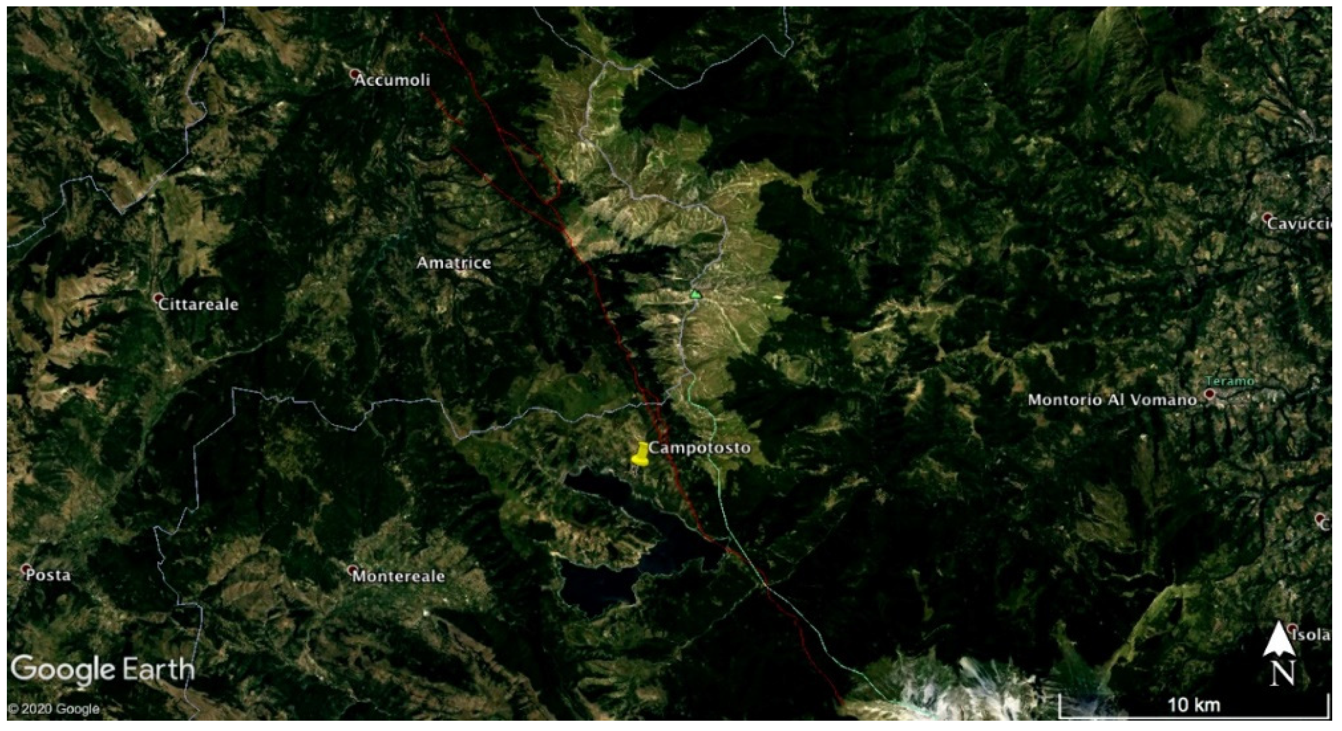
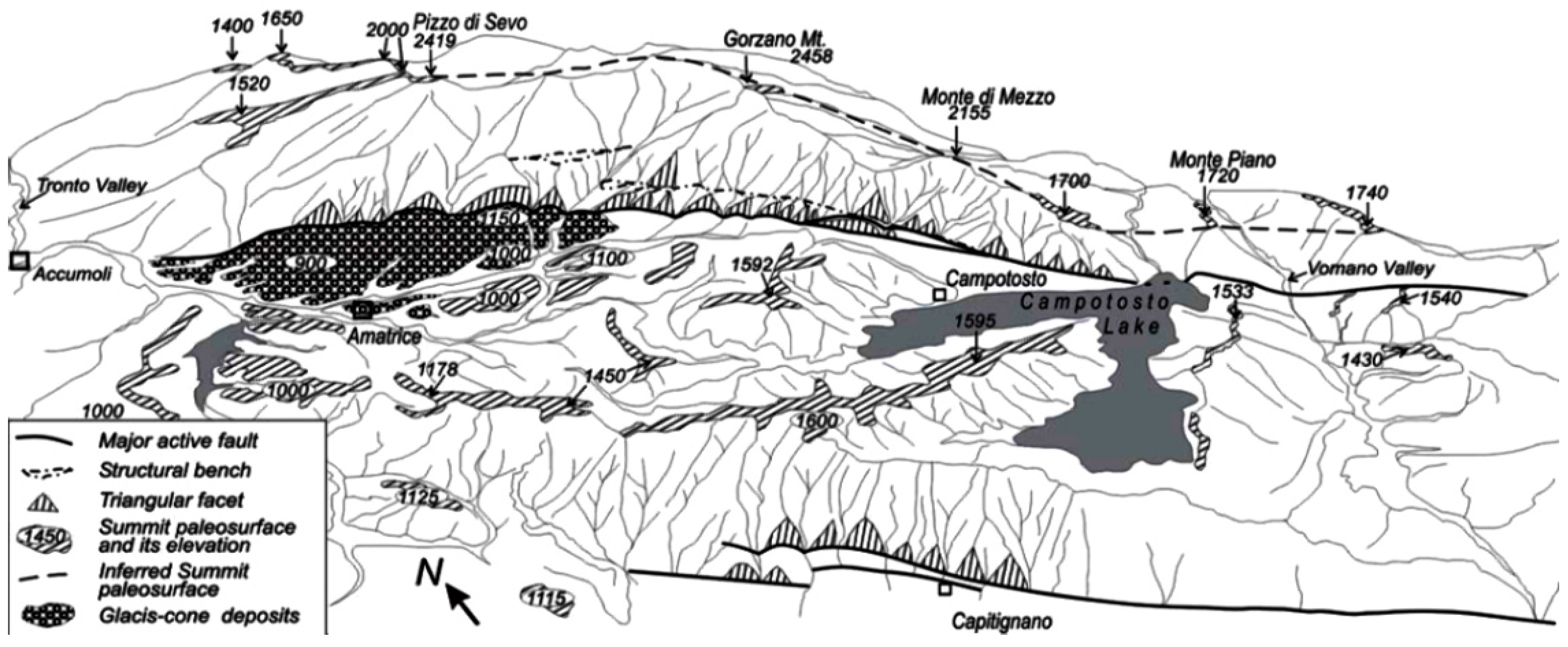
2.1. Experimental

The study area is located at Campotosto (42°55’ N and 13°38’ E), a small village approximately 20 km away from L’Aquila city, in the Abruzzo region (Central Italy, Figure 1). Abruzzo lies in the Apennine chain. In the vicinity of Campotosto, there is a significant active fault, the so called Mount Gorzano fault, of approximately 28 km length (Figure 2), a normal-type fault with WSW-dipping and a length-in-depth about 19.6 km [41,42,43,44]. Moreover, the rocks that outcrop in this study area are a flysh-type succession called the pre-evaporitic member of the Laga Formation [45]. This specific stratigraphic succession found in the study area is the arenaceous-pelitic (LAG4, lower Messinian [46]), characterized by the alternation of layers of sandstone and clay with relation A/P >1 [46]. This is a strategical study area because is very near to active faults that generated big earthquakes on 24 August 2016 and also on 26 and 30 October 2016 in Central Italy [43,44].
The 37 CO2 flux measurements were performed, independently, in two discrete phases, on 25 September 2019 and on 1 December 2019. Figure 3 presents all these 37 different measurements in the Campotosto area. During all the measurements, the climatic conditions were sunny without previous rain. Prior to data acquisition, superficial vegetation was removed in order to achieve the direct contact of the measuring device with the soil and rock underneath.
CO2 fluxes from soil were measured by a flux chamber unit constructed at the University ‘G. D’Annunzio’ of Chieti-Pescara, Italy. The instrument consists of a cylindrical stainless steel container of 30 cm diameter and of 18 cm height (12.72 L volume-chamber). The unit was calibrated and tested for measurement accuracy. The calibration phase was implemented through the use of a laboratory-constructed system, which controlled the flow of various air and CO2 mixtures (via a LabView program (National Instruments Corporation, Austin, TX, USA)), while concurrently measuring the flow with an external Mass Flow Controllers made by MKS Instrument, type 1179 Mass-Flo® Controller (Wilmington, MA, USA) and an internal CDM4160 (Figaro®) pre-calibrated module that was installed inside the flux chamber for carbon dioxide measurement (value range: 390–4000 ppm of CO2 concentration). The calibration factor of the flux chamber unit was calculated as the slope of the least-squares fit between the CO2 concentrations measured by the chamber unit (internal controller) and the flow-driven CO2 concentrations measured by the external units.
All the fluxes were calculated according to [47] by the equation:
ϕ gas = α H c
where α is the slope of the increase in gas concentration over time and H c is the height of the chamber. Using Equation (1), the CO2 fluxes were evaluated, and the relative results are shown in Figure 3 in ppm cm 2 s 1 .
The test phase was implemented to determine the quality of the CO2 concentration measurements provided by the internal module of the unit. Two main tests were carried out: the first was implemented through increasing steps of the CO2 concentrations driven to the chamber unit, and the second, through decreasing steps of CO2 concentrations. Between each experimentation, adequate time was left for the CO2 concentration values of the chamber to return to the corresponding baseline ones, which are usually around 400 ppm. In this way, the dead-time interval of the flux chamber unit was calculated, i.e., the time needed for the unit to return to its baseline recordings.
Proper sensors inside the chamber measured the temperature, pressure and humidity. Specifically, the LM35CAZ Precision Centigrade Temperature Sensor (National Semiconductor®, Santa Clara, CA, USA) was employed for temperature measurements, the XFPM-115KPA (Fujikura®, Tokyo, Japan) was used to measure atmospheric pressure, and the Honeywell® (Charlotte, NC, USA) HIH-4000 Series was utilized for relative humidity (RH) measurement. Moreover, the pressure inside and outside the chamber was balanced by a pressure compensation valve located at the top of the chamber. A rotating rod of carbon fibre and a gear motor (set to rotate less than 60 r/min) located inside the chamber reduces any bias effect due to gas stratification inside the chamber. The data were stored and saved every second with an Arduino board, mounted at the top of the chamber.

2.2. Mathematical Aspects
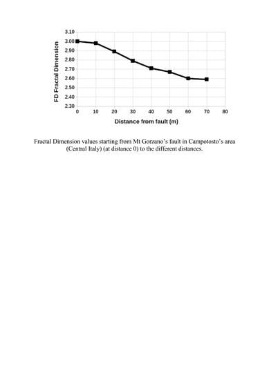
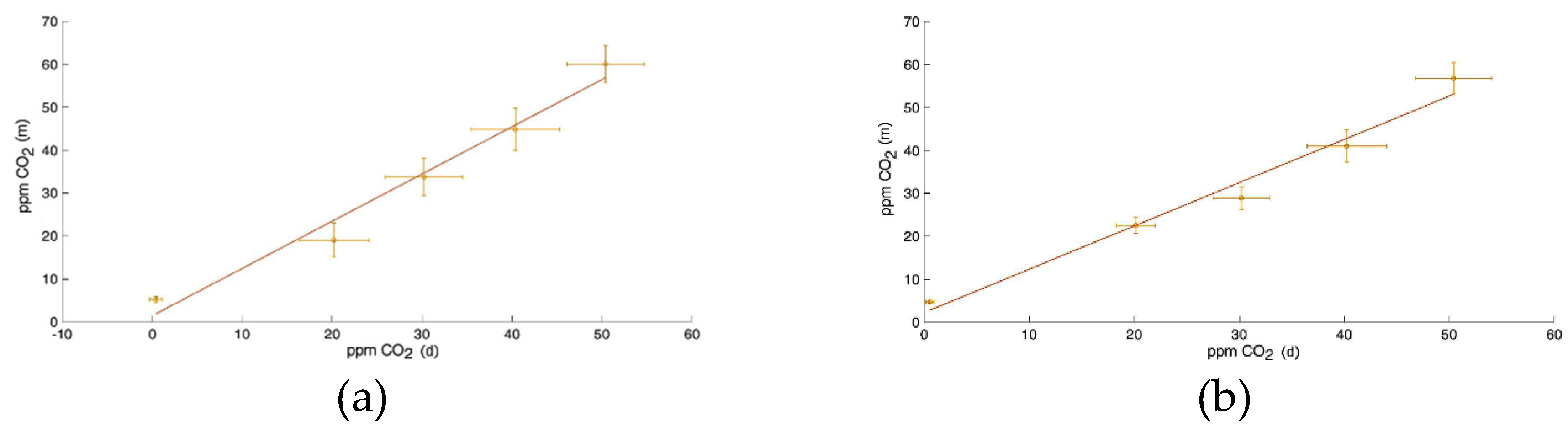
Spatial analysis based on the direction of measurements may provide important information regarding the fractal dimension (FD) and related scale-dependent phenomena [24,29,36]. Using experimental variogram analysis [36,48], it is possible to determine the fractal dimension according to Equation (2).
y ^ ( h ) = 1 2 N ( h ) i = 1 N ( h ) [ Z ( x i ) Z ( x i + h ) ] 2
where y ^ ( h ) is the semi-variance of points separated at a distance h , N is the number of pairs of points separated by h distance, Z ( x i ) is the value of the attribute at position x i and Z ( x i + h ) is the value of the same attribute in position x i + h .
The spatial structure of fractal surfaces can be described by means of a power law, as shown in the following relation:
| z ( x ) z ( x + h ) | h H
where the location x has an attribute value z , with the separation distance h , and H is the fractal codimension or Hurst exponent [49]. If 0 < H 1 , the fractal codimension can be defined as follows:
H = d FD
where FD is the fractal dimension and d is the Euclidian dimension of the system in which the fractal distribution has been described. For lines, surfaces and volumes, d = 1 , 2 , 3 , respectively. Hence, for a distribution of a soil attribute, the fractal dimension is given by
FD = 3 H .
Comparing Equations (2) and (3), it is possible derive the semi-variance at a given scale as
y ^ ( h ) h 2 H
or as:
log [ y ^ ( h ) ] 2 H log [ h ] .
Through a logaritmic transformation, the slope of the experimental variogram can be calculated on the log–log scale as 2 H . The H exponent can then be obtained by means of a linear regression on the log–log graph by the following equation [23]:
( log [ y ^ ( h ) ] 2 log [ h ] ) .
When H = 0 , the value of FD is equal to 3, which represents the lack of a spatial variability structure, as there would be no relationship between the way the attribute varies in space and the distance between the points. In this case, there is no fractal dimension, and the methodology does not apply. However, when 0 < H < 1 , the fractal dimension has values that characterize the presence of spatial variability and dependence with h [29,31]. According to Equation (5), 2.0 ≤ FD ≤ 3.0. When 2.0 ≤ FD ≤ 2.5, there is a persistence behavior, while if 2.5 ≤ FD ≤ 3.0, there is an anti-persistence behavior [29,36].

3. Results

The results of the calibration phase are given first. These results are very important because they verify the CO2 measurements provided by the flux chamber unit and validate the method of the measurements. As aforementioned, two calibration factors were calculated, corresponding to increasing and decreasing steps of CO2 driven concentrations. These are characteristically shown in Figure 4. The least-squares fit for Figure 4a is y = 1.1008 x + 1.4180 with R 2 = 0.9759 , and for Figure 4b, y = 1.0075 x + 2.2513 with R 2 = 0.9771 . Both lines have a very high square of the Spearman’s correlation coefficient. This means that the flux chamber unit very accurately records the pre-determined CO2 concentrations driven inside and originating from the external mass flow controllers. It is worth mentioning that the two mass flow controllers are good devices and that, therefore, the pre-determined driven CO2 concentrations are very well defined. Hence, it is expected that in real-time situations, the CO2 measurements will be accurate and reliable.
The measurements carried out in the Campotosto area to delineate the CO2 flux profiles of the Mount Gorzano fault and its vicinity are shown in Figure 3 The map shows the 37 CO2 flux measurements that were performed at various distances and positions from the fault. The maximum flux measured was 25.84 ppm cm−2 s−1, and the minimum one was 2.858 ppm cm−2 s−1. As can be observed from Figure 3, high CO2 flux values (from 20 to 25 ppm cm−2 s−1) are found near the fault, while, on the contrary, lower flux values (from 2 to 4 ppm cm−2 s−1) can be observed in positions far from it. Tectonic fracture is related to the deformation pattern along the fault system and also facilitates a pathway for the CO2 gasses [50,51,52], therefore leading to elevated fluxes near the fault. It should be noted that the soil CO2 flux can be influenced by the rock type and by other parameters like chemical, physical and biological processes, including the soil temperature and atmospherical pressure [28,53]. Since the confirmation of the above observations needs further analysis, it is crucial that appropriate methods are employed. A significant approach towards this is monitoring the spatial fractal behavior of the CO2 fluxes [29,36]. In association, it is significant to mention that the measurements were conducted following, as much as possible, the perpendicular direction (45° direction) with respect to the fault position. The scope was to acquire adequate profiles for statistical analyses. There are a variety of heights and spatial distributions of the measuring points in this study. The different distribution of heights is due to the morphology of the study area. Nevertheless, it seems that the surface profile of the fault is not a straight line (see Figure 3). Since the experimental approach of 45 degrees could not be followed exactly due to the morphology, further analysis in terms of the fractal semi-variogram method was attempted. In the following sections, this analysis is presented in detail.
As mentioned in the methods section and according to [36,54,55], the semi-variogram method is very efficient for the delineation of the hidden spatial trends in the CO2 flux measurements. Since a spatial distribution of points has been achieved from the measurement procedure, the following alternative methods were employed for the calculation of fractal dimensions with the semi-variogram method: (1) reorganizing the flux measurements in four different directions (horizontal, vertical, 45° and 135°) via arbitrarily selecting pairs of measurements from the whole dataset (each pair indicated with a different ID number), so that all the selected series of pairs correspond to each one of the four directions; (2) reorganizing the series of pairs of 1), with reference to their intra-pair distance; and (3) arbitrary selecting pairs of measurements with different distances from the fault. The fractal dimensions with reference to the horizontal direction (Figure 5a) exhibited values of 1.5 ≤ FD ≤ 3.0. The fractal dimensions with reference to the vertical direction (Figure 5b) exhibited values of 1.5 ≤ FD ≤ 3.0. The fractal dimensions with reference to the 45° direction (Figure 5c) all had values over 2.5; in particular, certain fractal dimension values were found of 2.85 ≤ FD ≤ 2.9 and 2.8 ≤ FD ≤ 2.85. The fractal dimensions with reference to the 135° direction (Figure 5d) present values of 2.0 ≤ FD ≤ 3.0.
Figure 6 presents fractal dimensions with reference to the distance in the four spatial directions. These are the distances between the various points that are spatially dispersed. Due to the scattering of the measurement points, there are a variety of distances from 20 m to 140 m. Note that Figure 6 is a reorganization of Figure 5 with reference to the distance and not to the ID number. Since there is no preferred direction in the above distances, Figure 6 has a different distribution of values in both the horizontal and vertical axes. It is very important to mention that all the fractal dimension values are over 2.5. This is a very significant finding that implies a strong fractal behavior of the CO2-generating system in the spatial manner because the Hurst exponent (H) is between 0 and 0.5 [47,55]. This significant finding implies that when a high CO2 concentration value is found, the next value will be low, and this tendency follows throughout the Campotosto area. Strong anti-persistent, long-lasting interaction exists. Observing that most high values are near the fault, the anti-persistence behavior justifies that the values after the fault will be low while the remaining values will have a trend of higher–lower values; all these values are lower than the corresponding values on the fault [56]. The fractal dimensions in the horizontal direction (Figure 6a) were all over 2.5; in particular, FD ≥ 2.9 at 40 and 80 m; 2.8 ≤ FD ≤ 2.9 at 50, 100 and 120 m; 2.6 ≤ FD ≤ 2.7 at 30, 90 and 110 m; and FD ≤ 2.6 at 60 m. The fractal dimensions in the vertical direction (Figure 6b) are all above 2.5; in particular, the FD is above or equal to 2.9 at 40 and 90 m; 2.8 ≤ FD ≤ 2.9 at 60 m; 2.7 ≤ FD ≤ 2.8 at 70, 90, 100 and 130 m; and FD ≤ 2.7 at 140 m. The fractal dimensions in the 45° plane (Figure 6c) are all over 2.5; in particular, 2.7 ≤ FD ≤ 2.8 at 20, 30 and at 50 m; and 2.6 ≤ FD ≤ 2.7 at 40 and 60 m. The fractal dimensions in the 135° plane (Figure 6d) are between 2.90 and 2.98.
This is characteristically shown in Figure 7 where the fractal dimensions with reference to the distance from the fault are presented. Figure 7 is the result of all the fractal dimension values taken at different positions from the fault. It is evident that the fractal dimension values away from the fault are lower. This finding verified the above facts in an alternative way. The fractal dimension values at greater distances are lower and, therefore, they follow the tendency of the CO2 concentrations to exhibit anti-persistent behavior of lower intensity at greater distances. This means that the system goes away from strong anti-persistence and fractality when it is away from the fault; strong anti-persistence gradually diminishes. The significance of the strong anti-persistence behavior has been mentioned by several publications [56,57,58,59,60]. In the above publications, it was reported, in a multi-facet way, that the strong anti-persistent behavior, similarly to the strong persistence behavior, is a footprint of hidden activity in soil radon or environmental electromagnetic disturbances. According to [12], the radon in soil and CO2 fluxes from soil may have similar origins inside the Earth’s crust prior to seismic activity. It is the micro-crack branching, as possibly in the Mount Gorzano fault, that may act as a pathway for the increase in radon and CO2 concentrations from soil. According to [61,62,63], the CO2 fluxes increase inside the fault. All these aspects report different faces of the same aspect; the Mount Gorzano fault, as a seismic area, is associated with a strong CO2 pathways and increased CO2 concentration fluxes.
The above findings are verified by the results of other investigators. For example, [29] reported similar results showing comparable fractal dimension values between 2.5 and 3.0 of the spatial variability of soil CO2 emissions, where it was shown that the fractal dimension decreased, as well, with the distance. This very important finding is similar to the tendency shown in Figure 7 and should be emphasized. This tendency of a decrease in the CO2 values with the distance was also reported by these authors. This is an additional verification of the findings of this work. Additionally, [36] reported a similar range of fractal dimension values as in this work, where the fractal dimension values were between 2.5 and 3.0 from 5 m to 60 m, also decreasing with the distance. Furthermore, [55] calculated—also with the experimental variogram method, using the same equation as Equation (2) of this publication—the spatial variability of soil CO2 fluxes. All the findings of this paper are comparable to those of other related papers, despite the fact that the sample size was not very high. More or less, the accuracy of the employed measuring device in conjunction with the modern methodological approach contributed towards this achievement.

4. Conclusions

The technique used for this work was an experimental semi-variogram that was applied to measuring CO2 fluxes at the Campotosto seismic area (central Italy). Non-continuous spatial and temporal phenomena were addressed from the measurements.
The fractal dimension values at greater intra-distances and greater distances from the fault are lower and, therefore, they follow the tendencies of the CO2 concentrations, to exhibit anti-persistent behavior of lower intensity at greater distances.
The fractal dimensions of this work are within the value ranges reported in similar work.

Author Contributions

Conceptualization, S.D., N.C., D.N.; Data curation, P.D.C. and E.A.; Formal analysis, D.N., E.P.; Investigation, S.D., P.D.C., E.A.; Methodology, D.N., I.V.; Resources, G.P.; Software, D.N. and N.C.; Supervision, D.N., P.D.C. and I.V.; Visualization, D.N.; Writing—original draft, S.D. and N.C.; Writing—review & editing, D.N., E.P., P.H.Y. and G.P. All authors have read and agreed to the published version of the manuscript.

Funding

This research received no external funding.

Conflicts of Interest

The authors declare no conflict of interest.

References

  1. King, C.Y. Impulsive radon emanation on a creeping segment of the San Andreas fault, California. Pure Appl. Geophys. 1985, 122, 340–352. [Google Scholar] [CrossRef]
  2. Ciotoli, G.; Guerra, M.; Lombardi, S.; Vittori, E. Soil gas survey for tracing seismogenic faults: A case study in the Fucino basin, Central Italy. J. Geophys. Res. 1998, 103, 23781–23794. [Google Scholar] [CrossRef]
  3. Baubron, J.C.; Rigo, A.; Toutain, J.P. Soil gas profiles as a tool to characterize active tectonic areas: The Jaut Pass example (Pyrenees, France). Earth Planet. Sci. Lett. 2002, 196, 69–81. [Google Scholar] [CrossRef]
  4. Ciotoli, G.; Lombardi, S.; Annunziatellis, A. Geostatistical analysis of soil gas data in a high seismic intermontane basin: Fucino Plain, central Italy. J. Geophys. Res. 2007, 112, B05407. [Google Scholar] [CrossRef]
  5. Fu, C.C.; Yang, T.F.; Du, J.; Walia, V.; Chen, Y.G. Variations of helium and radon concentrations in soil gases from an active fault zone in Southern Taiwan. Radiat. Meas. 2008, 43, S348–S352. [Google Scholar] [CrossRef]
  6. Walia, V.; Yang, T.; Hong, W.; Lin, S.; Fu, C. Geochemical variation of soil–gas composition for fault trace and earthquake precursory studies along the Hsincheng fault in NW Taiwan. Appl. Radiat. Isot. 2009, 67, 1855–1863. [Google Scholar] [CrossRef]
  7. Bigi, S.; Beaubien, S.E.; Ciotoli, G.; D’Ambrogi, C.; Doglioni, C.; Ferrante, V.; Lombardi, S.; Milli, S.; Orlando, L.; Ruggiero, L.; et al. Mantle-derived CO2 migration along active faults within an extensional basin margin (Fiumicino, Rome, Italy). Tectonophysics 2014, 637, 137–149. [Google Scholar] [CrossRef]
  8. Ciotoli, G.; Sciarra, A.; Ruggiero, L.; Annunziatellis, A.; Bigi, S. Soil gas geochemical behaviour across buried and exposed faults during the 24th August 2016 central Italy earthquake. Ann. Geophys. 2016, 59. [Google Scholar] [CrossRef]
  9. Wakita, H.; Nakamura, Y.; Notsu, K.; Noguchi, M.; Asada, T. Radon anomaly: A possible precursor to the 1978 Izu-Oshima-kinkai earthquake. Science 1980, 207, 882–883. [Google Scholar] [CrossRef]
  10. Reddy, D.V.; Sukhija, B.S.; Nagabhushanam, P.; Kumar, D. A clear case of radon anomaly associated with a microearthquake event in a stable continental region. Geophys. Res. Lett. 2004, 31, L10609. [Google Scholar] [CrossRef]
  11. Perez, N.M.; Hernandez, P.A.; Padron, E.; Melian, G.; Marrero, R. Precursory Subsurface 222Rn and 220Rn Degassing Signatures of the 2004 Seismic Crisis at Tenerife, Canary Islands. Pure Appl. Geophys. 2007, 164, 2431–2448. [Google Scholar] [CrossRef]
  12. Cicerone, R.; Ebel, J.E.; Britton, J. A systematic compilation of earthquake precursors. Tectonophysics 2009, 476, 371–396. [Google Scholar] [CrossRef]
  13. Ghosh, D.; Deb, A.; Sengupta, R. Anomalous radon emission as precursor of earthquake. J. Appl. Geophys. 2009, 69, 67–81. [Google Scholar] [CrossRef]
  14. Hashemi, S.; Negarestani, A.; Namvaran, M.; Nasab, S.M.M. An analytical algorithm for designing radon monitoring network to predict the location and magnitude of earthquakes. J. Radioanal. Nucl. Chem. 2013, 295, 2249–2262. [Google Scholar] [CrossRef]
  15. Petraki, E.; Nikolopoulos, D.; Panagiotaras, D.; Cantzos, D.; Yannakopoulos, P. Radon-222: A Potential Short-Term Earthquake Precursor. J. Earth Sci. Clim. Chang. 2015, 6, 282. [Google Scholar] [CrossRef]
  16. Rice, J.R. Fault stress states, pore pressure redistributions, and the weakness of the San Andreas fault. In Fault Mechanics and Transport Properties of Rock; Evans, B., Wong, T.F., Eds.; Academic Press Ltd.: San Diego, CA, USA, 1992; pp. 476–503. [Google Scholar]
  17. Sibson, R.H. Fluid involvement in normal faulting. J. Geodyn. 2000, 29, 449–469. [Google Scholar] [CrossRef]
  18. Collettini, C.; Cardellini, C.; Chiodini, G.; De Paola, N.; Holdsworth, R.E.; Smith, S.A.F. Fault weakening due to CO2 degassing in the Northern Apennines: Short and long-term processes. Geol. Soc. Lond. Spec. Publ. 2008, 299, 175–194. [Google Scholar] [CrossRef]
  19. King, C.Y.; King, B.S.; Evans, W.C.; Zhang, W. Spatial radon anomalies on active faults in California. Appl. Geochem. 1996, 11, 497–510. [Google Scholar] [CrossRef]
  20. Annunziatellis, A.; Beaubien, S.E.; Bigi, S.; Ciotoli, G.; Coltella, M.; Lombardi, S. Gas migration along fault systems and through the vadose zone in the Latera caldera (central Italy): Implications for CO2 geological storage. Int. J. Greenh. Gas Control 2008, 2, 353–372. [Google Scholar] [CrossRef]
  21. Sciarra, A.; Fascetti, A.; Moretti, A.; Cantucci, B.; Pizzino, L.; Lombardi, S.; Guerra, I. Geochemical and radiometric profiles through an active fault in the Sila Massif (Calabria, Italy). J. Geoch. Explor. 2014, 148, 128–137. [Google Scholar] [CrossRef]
  22. Mandelbrot, B.B. The fractal geometry of nature. Review by: Cannon, J.W. Am. Math. Mon. 1984, 91, 594–598. [Google Scholar] [CrossRef]
  23. Perfect, E.; Kay, B.D. Applications of fractals in soil and tillage research: A review. Soil Till. Res. 1995, 36, 1–20. [Google Scholar] [CrossRef]
  24. Eghball, B.; Hergert, G.W.; Lesoing, G.W.; Ferguson, R.B. Fractal analysis of spatial and temporal variability. Geoderma 1999, 88, 349–362. [Google Scholar] [CrossRef]
  25. Mandelbrot, B.B. Fractals: Form, Chance, and Dimension; W.H. Freeman: San Francisco, CA, USA, 1977; p. 365. [Google Scholar]
  26. Pachepsky, Y.; Crawford, J.W. Fractal analysis. In Encyclopedia of Soils in the Environment; Hillel, D., Ed.; Academic Press: Waltham, MA, USA, 2004; Volume 2, pp. 85–98. [Google Scholar]
  27. Allaire, S.E.; Lange, S.F.; Lafond, J.A.; Pelletier, B.; Cambouris, A.N.; Dutilleul, P. Multiscale spatial variability of CO2 emissions and correlations with physico-chemical soil properties. Geoderma 2012, 170, 251–260. [Google Scholar] [CrossRef]
  28. Ryu, S.; Concilio, A.; Chen, J.; North, M.; Ma, S. Prescribed burning and mechanical thinning effects on below-ground conditions and soil respiration in a mixed-conifer forest, California. For. Ecol. Manag. 2009, 257, 1324–1332. [Google Scholar] [CrossRef]
  29. Panosso, A.R.; Perillo, L.I.; Ferraudo, A.S.; Pereira, G.T.; Miranda, J.G.V.; La Scala, N. Fractal dimension and anisotropy of soil CO2 emission in a mechanically harvested sugarcane production area. Soil Till. Res. 2012, 124, 8–16. [Google Scholar] [CrossRef]
  30. Burrough, P.A. Fractal dimensions of landscapes and other environmental data. Nature 1981, 294, 240–242. [Google Scholar] [CrossRef]
  31. Palmer, M.W. Fractal geometry: A tool for describing spatial patterns of plant communities. Vegetatio 1988, 75, 91–102. [Google Scholar] [CrossRef]
  32. La Scala, N., Jr.; Marques, J., Jr.; Pereira, G.T.; Corà, J.E. Short-term temporal changes in the spatial variability model of CO2 emissions from a Brazilian bare soil. Soil Biol. Biochem. 2000, 32, 1459–1462. [Google Scholar] [CrossRef]
  33. Ohashi, M.; Gyokusen, K. Temporal change in spatial variability of soil respiration on a slope of Japanese cedar (Cryptomeria japonica D. Don) forest. Soil Biol. Biochem. 2007, 39, 1130–1138. [Google Scholar] [CrossRef]
  34. Kosugi, Y.; Mitani, T.; Ltoh, M.; Noguchi, S.; Tani, M.; Matsuo, N.; Takanashi, S.; Ohkubo, S.; Nik, A.R. Spatial and temporal variation in soil respiration in a Southeast Asian tropical rainforest. Agric. For. Meteorol. 2007, 147, 35–47. [Google Scholar] [CrossRef]
  35. Konda, R.; Ohta, S.; Ishizuka, S.; Aria, S.; Ansori, S.; Tanaka, N.; Hardjono, A. Spatial structures of N2O, CO2 and CH4 fluxes from Acacia mangium plantation soils during a relatively dry season in Indonesia. Soil Biol. Biochem. 2008, 40, 3021–3030. [Google Scholar] [CrossRef]
  36. Bicalho, E.S.; Panosso, A.R.; Teixeira, D.D.B.; Miranda, J.G.V.; Pereira, G.T.; La Scala, N. Spatial variability structure of soil CO2 emission and soil attributes in a sugarcane area. Agric. Ecos. Environ. 2014, 189, 206–215. [Google Scholar] [CrossRef]
  37. Telesca, L.; Lapenna, V.; Macchiato, M. Multifractal fluctuations in seismic interspike series. Phys. A 2005, 354, 629–640. [Google Scholar] [CrossRef] [Green Version]
  38. Chamoli, A.; Yadav, R.B.S. Multifractaly in seismic sequences of NW Himalaya. Nat. Hazards 2015, 77, s19–s32. [Google Scholar] [CrossRef]
  39. Weinlich, F.H. Carbon dioxide controlled earthquake distribution pattern in the NW Bohemian swarm earthquake region, western Eger Rift, Czech Republic—Gas migration in the crystalline basement. Geofluids 2014, 14, 143–159. [Google Scholar] [CrossRef]
  40. Fischer, T.; Matyska, C.; Heinicke, J. Earthquake-enhanced permeability–evidence from carbon dioxide release following the ML 3.5 earthquake in West Bohemia. Earth Planet. Sci. Lett. 2017, 460, 60–67. [Google Scholar] [CrossRef]
  41. Boncio, P.; Lavecchia, G.; Milano, G.; Rozzi, B. Seismogenesis in central Appennines, Italy: An integrated analysis of minor earthquake sequences and structural data in the Amatrice-Campotosto Area. Ann. Geophys. 2004, 47, 1723–1742. [Google Scholar]
  42. Pace, B.; Peruzza, L.; Lavecchia, G.; Boncio, P. Layered seismogenic source model and probabilistic seismic-hazard analyses in central Italy. Bull. Seismol. Soc. Am. 2006, 96, 107–132. [Google Scholar] [CrossRef]
  43. Lavecchia, G.; Castaldo, R.; de Nardis, R.; De Novellis, V.; Ferrarini, F.; Pepe, S.; Brozzetti, F.; Solaro, G.; Cirillo, D.; Bonano, M.; et al. Ground deformation and source geometry of the 24 August 2016 Amatrice earthquake (Central Italy) investigated through analytical and numerical modelling of DInSAR measurements and structural-geological data. Geophys. Res. Lett. 2016, 43. [Google Scholar] [CrossRef]
  44. Brozzetti, F.; Boncio, P.; Cirillo, D.; Ferrarini, F.; de Nardis, R.; Testa, A.; Liberi, F.; Lavecchia, G. High-resolution field mapping and analysis of the August–October 2016 coseismic surface faulting (central Italy earthquakes): Slip distribution, parameterization, and comparison with global earthquakes. Tectonics 2019, 38. [Google Scholar] [CrossRef] [Green Version]
  45. Blumetti, A.M.; Guerrieri, L. Fault-generated mountain fronts and the identification of fault segments: Implications for seismic hazard assestment. Boll. Soc. Geol. Ital. 2007, 126, 307–322. [Google Scholar]
  46. Festa, A. Geometrie e meccanismi di raccorciamento nel settore meridionale del Bacino marchigiano (Monte Gorzano, Appennino centrale). Ital. J. Geosci. 2005, 124, 41–51. [Google Scholar]
  47. Chiodini, G.; Cioni, R.; Guidi, M.; Raco, B.; Marini, L. Soil CO2 flux measurements in volcanic and geothermal areas. Appl. Geochem. 1998, 13, 543–552. [Google Scholar] [CrossRef]
  48. Vidal Vazquez, E.; Miranda, J.G.V.; Paz González, A. Characterizing anisotropy and heterogeneity of soil surface microtopography using fractal models. Ecol. Model. 2005, 182, 337–353. [Google Scholar] [CrossRef]
  49. Huang, C.H.; Bradford, J.M. Applications of a laser scanner to quantify soil microtopography. Soil Sci. Soc. Am. J. Abstr. 1992, 56, 14–21. [Google Scholar] [CrossRef]
  50. Lewicki, J.L.; Evans, W.C.; Hilley, G.E.; Sorey, M.L.; Rogie, J.D.; Brantley, S.L. Shallow soil CO2 flow along the San Andreas and Calaveras Faults, California. J. Geophys. Res. 2003, 108. [Google Scholar] [CrossRef] [Green Version]
  51. Walia, V.; Lin, S.J.; Fu, C.C.; Yang, T.F.; Hong, W.L.; Wen, K.L.; Chen, C.H. Soil-gas monitoring: A tool for fault delineation studies along Hsnhua Fault (Tainan), Southern Taiwan. App. Geoch. 2010, 25, 602–607. [Google Scholar] [CrossRef]
  52. Jung, B.; Garven, G.; Boles, J.R. Effects of episodic fluid flow on hydrocarbon migration in the Newport-Inglewood Fault Zone, Southern California. Geofluids 2014, 14, 234–250. [Google Scholar] [CrossRef]
  53. Concilio, A.; Chen, J.Q.; Ma, S.; North, M. Precipitation drives interannual vari- ation in summer soil respiration in a Mediterranean-climate, mixed-conifer forest. Clim. Chang. 2009, 92, 109–122. [Google Scholar] [CrossRef]
  54. Cantero, J.J.; Leon, R.; Cisneros, J.M.; Cantero, A. Habitat structure and vegetation relationships in central Argentina salt marsh landscapes. Plant Ecol. 1998, 137, 79–100. [Google Scholar] [CrossRef]
  55. Tavares, R.L.M.; Souza, Z.M.; La Scala, N., Jr.; Castioni, G.A.F.; Souza, G.S.; Torres, J.L.T. Spatial and Temporal Variability of Soil CO2 Flux in Sugarcane Green Harvest Systems. Rev. Bras. Cienc. Solo 2016, 40. [Google Scholar] [CrossRef]
  56. Nikolopoulos, D.; Petraki, E.; Yannakopoulos, P.; Cantzos, D.; Panagiotaras, D.; Nomicos, C. Fractal Analysis of Pre-Seismic Electromagnetic and Radon Precursors: A Systematic Approach. J. Earth. Sci. Clim. Chang. 2016, 7. [Google Scholar] [CrossRef] [Green Version]
  57. Nikolopoulos, D.; Petraki, E.; Vogiannis, E.; Chaldeos, Y.; Yannakopoulos, P.; Kottou, S.; Nomicos, C.; Stonham, J. Traces of self-organisation and long-range memory in variations of environmental radon in soil: Comparative results from monitoring in Lesvos Island and Ileia (Greece). J. Radioanal. Nucl. Chem. 2014, 299, 203–219. [Google Scholar] [CrossRef]
  58. Petraki, E.; Nikolopoulos, D.; Chaldeos, Y.; Koulouras, G.; Nomicos, C.; Yannakopoulos, P.; Kottou, S.; Stonham, J. Fractal evolution of MHz electromagnetic signals prior to earthquakes: Results collected in Greece during 2009. Geomat. Nat. Hazards Risk 2016, 7, 550–564. [Google Scholar] [CrossRef] [Green Version]
  59. Nikolopoulos, D.; Matsoukas, C.; Yannakopoulos, P.; Petraki, E.; Cantzos, D.; Nomicos, C. Long-Memory and Fractal Trends in Variation of Environmental Radon in Soil: Results from Measurements in Less Island in Greece. J. Earth Sci. Clim. Chang. 2018, 9, 1–11. [Google Scholar]
  60. Nikolopoulos, D.; Petraki, E.; Nomicos, C.; Koulouras, G.; Kottou, S.; Yannakopoulos, P. Long-memory trends in disturbances of radon in soil prior to the twin ML = 5.1 earthquakes of 17 November 2014 Greece. J. Earth Sci. Clim. Chang. 2015, 6, 1–10. [Google Scholar]
  61. Italiano, F.; Bonfanti, P.; Ditta, M.; Petrini, R.; Slejko, F. Helium and carbon isotopes in the dissolved gases of Friuli Region (NE Italy): Geochemical evidence of CO2 production and degassing over a seismically active area. Chem. Geol. 2009, 266, 76–85. [Google Scholar] [CrossRef]
  62. Quattrocchi, F.; Pizzi, A.; Gori, S.; Boncio, P.; Voltattorni, N.; Sciarra, A. The contribution of fluid geochemistry to define the structural patterns of the 2009 L’Aquila seismic source. Ital. J. Geosci. 2012, 131, 448–458. [Google Scholar] [CrossRef]
  63. Martinelli, G.; Plescia, P. Mechanochemical dissociation of calcium carbonate: Laboratory data and relation to natural emission of CO2. Phys. Earth Planet. Inter. 2004, 142, 205–214. [Google Scholar] [CrossRef]
Figure 1. Map of study area in proximity to Campotosto in Central Italy. The figure presents the Mount Gorzano fault (red line) [43,44] and the main cities.
Geosciences 10 00233 g001
Figure 2. Geomorphological map of the study area. Map taken from [45].
Geosciences 10 00233 g002
Figure 3. The map of the full set of measurements (flux values in ppm cm−2 s−1), with the fault position [43,44] shown with a red line. The x axis represents the latitude from 42°33′23.436″ N to 42°33′38.286″ N, while the y axis represents the longitude from 13°22′58.962″ E to 13°23′17.3832″ E.
Geosciences 10 00233 g003
Figure 4. The best-line fits of the two tests: the first, (a) reports the increasing concentration test, while the second, (b), the decreasing concentration test. In both figures, the x axis (ppm CO2 (d)) reports the CO2 concentrations driven into the flux chamber unit, while the y axis (ppm CO2 (m)) reports the CO2 concentrations measured.
Geosciences 10 00233 g004
Figure 5. Fractal dimension (FD) values found in different planes in four spatial directions. (a) FD values in the horizontal plane. (b) FD values in the vertical plane. (c) FD values in the 45° plane. (d) FD values in the 135° plane.
Geosciences 10 00233 g005
Figure 6. Fractal dimension (FD) values with different distances in the four spatial directions. (a) FD values in the horizontal direction. (b) FD values in the vertical direction. (c) FD values in the 45° direction. (d) FD values in the 135° direction.
Geosciences 10 00233 g006
Figure 7. Fractal dimension values from the fault (at distance 0) to the different distances.
Geosciences 10 00233 g007

