Article

The Khadzhokh Canyon System—An Important Geosite of the Western Caucasus

by
Anna V. Mikhailenko
1,
Dmitry A. Ruban
2,3,* and
Vladimir A. Ermolaev
4
1
Department of Physical Geography, Ecology, and Nature Protection, Institute of Earth Sciences, Southern Federal University, Zorge Street 40, 344090 Rostov-on-Don, Russia
2
K.G. Razumovsky Moscow State University of Technologies and Management (The First Cossack University), Zemlyanoy Val Street 73, 109004 Moscow, Russia
3
Department of Hospitality Business, Higher School of Business, Southern Federal University, 23-ja Linija Street 43, 344019 Rostov-on-Don, Russia
4
Department of Commodity Science and Expertise, Plekhanov Russian University of Economics, Stremyanny Lane 36, 117997 Moscow, Russia
*
Author to whom correspondence should be addressed.
Geosciences 2020, 10(5), 181; https://doi.org/10.3390/geosciences10050181
Submission received: 28 April 2020 / Revised: 7 May 2020 / Accepted: 11 May 2020 / Published: 14 May 2020

Abstract

:
True diversity of geological heritage sites (geosites) is yet to be fully understood. New field studies of the Khadzhokh Canyon and its vicinities in the Western Caucasus (Mountainous Adygeya tourist destination, southwestern Russia) have allowed characterizing its geoheritage. Multiple unique features are assigned to geomorphological, stratigraphical, paleontological, palaeogeographical, sedimentary, tectonic, hydro(geo)logical, and coupled economical and geoexplorationgeoheritage types. This geoheritage is highlycomplex, and its rank is national. The unique features include (but not limited to) three canyons, Triassic stratigraphical sections, Late Jurassic coral reef, megaclast accumulations, chevron folds, and waterfalls. The geoheritage is distributed along the Khadzhokh Canyon and its branches. The configuration of thisgeositemakes it possible to propose a new category, namely dendritic geosites distinguished by continuous occurrence of geoheritage via branching stripes. Such geosites can be either natural (determined by dendritic drainage network and deep valley incision) or anthropogenic (determined by dendritic road network with lengthy road cuttings). In the former case, geosites are also geomorphosites and host viewpoint geosites.

Graphical Abstract

1. Introduction

International research interest in geological heritage (geoheritage) has grown exponentially since the mid-2000s. Of special interest are manifestations of unique features, namely geosites. Geositessensulato (this definition is preferred in the present work) include geological heritage sites (geositessensustricto) and geomorphological heritage sites (geomorphosites).The basic knowledge of geoheritage, geosites, and geomorphosites is presented in the synthetic works by Brilha [1], Henriques et al. [2], Prosser at al. [3], Reynard and Brilha [4], Ruban [5], Štrba [6], and Wimbledon and Smith-Meyer [7]. Generally, these objects represent unique phenomena of geological environment that are valuable as pieces of natural heritage, and these are also of scientific, educational, and tourism importance. Brilha et al. [8] and Ruban et al. [9] related such phenomena to ecosystemsand geosystem services. Geoheritage, geosites, and geomorphosites are also essential objects for geotourism development [10,11,12].
Geosites vary significantly, and different approaches have been proposed to classify them [3,5,13,14,15,16,17]. Generally, it is possible to distinguish geosites by several criteria (e.g., general appearance in space, dynamic state, origin of unique features, etc), but the relevant knowledge remains incomplete. For instance, Migoń and Pijet-Migoń [18] have recognized recently a new type of geosites, namely viewpoint geosites, andRuban [19] has made some updates of the earlier geosite classifications.Two-dimensional (2D) “geometry” of geosites is of special interest because it provides some important keys for efficient geoheritage mapping. For instance, Ruban [5] and Migoń and Pijet-Migoń [18] have recognized point, linear, and areal geosites (this seems to be an example of a rare coincidence of scientific thoughts—these specialists coined the same terms and for the same purpose independently from each other). The former are very small geosites looking like points on even local maps—e.g., these are typical outcrops. Linear geosites are lengthy (up to many kilometers), but very narrow (out of scale on many maps) exposures of geological phenomena. For instance, these arecontinuous stratigraphical sections along rivers or roads. Such geosites can be very important in roadside geotourism [20]. Finally, areal geosites are recognizable on maps, and these may embrace territories measured by square kilometers. Examples include, particularly, extensive karst fields. However, the above-mentioned categories embrace only some, if even very common geosites that are simplyorganized in space. In fact, there may be manifestations of unique phenomena with significantly more complex “geometry”. The relevant classifications are chiefly of theoretical importance, but these may be also helpful for some practical purposes, including more precise geosite description, official delineation, and geo-routes planning.
Field studies in the Western Caucasus (southwestern Russia) have permitted to document a highlyunique geomorphological and geological feature, namely the Khadzhokh Canyon, which is a system of several lengthy and deep canyons [5,21].The configuration of this feature is specific and complex. The main objective of the present contribution is a description of this important geosite in the ofthe new evidence. Moreover, new field investigations allow not only its re-consideration and extension of the available knowledge, but these also provide matter to propose a new category of geosites.

2. Geographical and Geological Setting

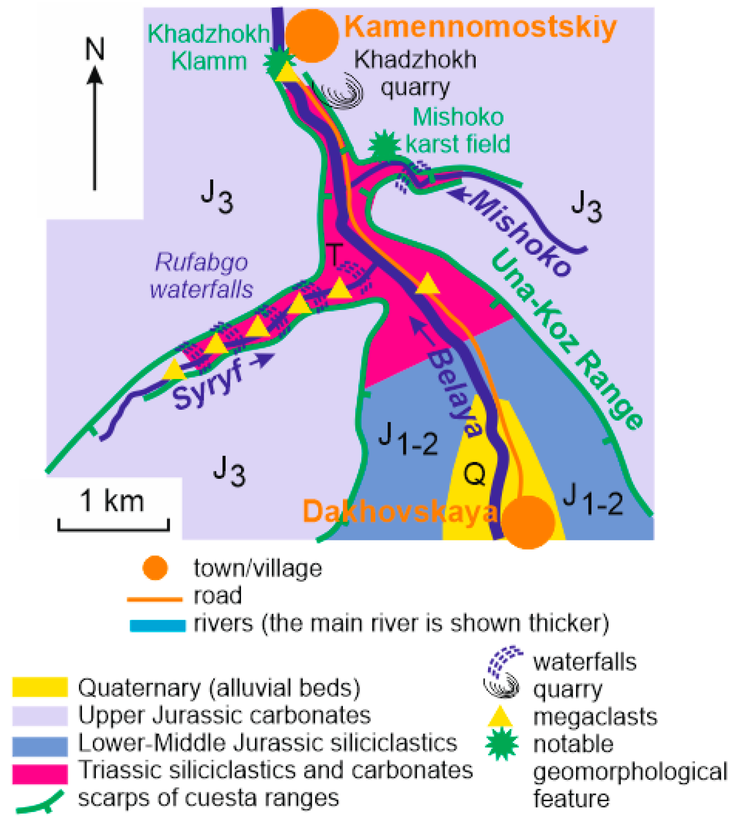
2.1. Geographical Setting

The study area is located in southwestern Russia and, particularly, in the southern, mountainous part of the Republic of Adygeya (one of the regions of the Russian Federation, Figure 1). Geographically, it belongs to the Western Caucasus, which is a part of the lengthy mountain chain of the Greater Caucasus stretching from the Black Sea in the west to the Caspian Sea in the east, along the borders of Russia, Georgia, and Azerbaijan.
The Greater Caucasus and, particularly, its western part are formed by several sub-parallel mountain ranges separated by lengthy depressions. Each of these ranges consists of smaller ranges, some of which retain local names. In the study area, the main range is the Skalistyy Range with amaximum height of up to 1000 m. The local name of its part is the Una-Koz Range (Figure 2). This range is a typical cuesta (such landforms are known from many places of the world, and these have been studied for more than a century [22,23,24,25,26,27,28,29,30,31]), the northern slope of which is very gentle, whereas the southern slope is steep, with a tall cliff (scarp). Formation of this cuesta is determined by the local geological setting (see below) where easy-to-erodeshales are overlain by difficult-to-erode limestones; the latter form a northward-dipping monocline.
The study area is situated in the watershed of the Belaya River, a left tributary of the big Kuban River flowing to the Azov Sea. The Belaya River crosses the area and flows to the north (Figure 2). This means it crosses the Skalistyy Range almost perpendicularly. Such correspondence of the range and the river results in deep (up to 500 m) and active incision of its U-shaped valley, i.e., the Khadzhokh Canyon (Belaya River canyon). The local tributaries of the Belaya River, namely the Mishoko River and the Syryf River also form canyons (the Mishoko Canyon and the Rufabgo Canyon, respectively), which are branches of the Khadzhokh Canyon (Figure 3a). The name of the latter is related to the traditional name of the town that is officially named Kamennomostskiy (however, Khadzhokh is reserved as thename of its railway station).

2.2. Geological Setting

Geologically, the study area belongs to the western domain of the Greater Caucasus, which is a Late Cenozoic orogen developed due to interaction of the Eurasian and Arabian plates and some smaller tectonic blocks [32,33,34,35,36]. The Khadzhokh Canyon and its vicinities are dominated by Triassic and Jurassic sedimentary rocks (Figure 2), and this is an example of the typical Tethyan geology. The Triassic deposits include the Induan–Olenekiansilicicalstics, volcaniclastics, and carbonates, the Anisianlimestones, the Ladinian–Carnianflysch-like siliciclastics, and the Norian mixed carbonate-siliciclastic deposits with the total thickness of ~1500 m [37,38]. Their accumulation occurred at the time of significant tectonic re-organizations on the southern periphery of Baltica that are yet to be understood. These strongly deformed complexes are exposed in an erosional “window” where the canyons are incised in the small Triassic tectonic block (Figure 3b) that was uplifted atthe end of the Middle Jurassic. The Jurassic sedimentary complexes dominate the study area (Figure 2). The Lower–Middle Jurassic sandstones and shales with the total thickness of up to 10 km [39] are intensively folded and faulted, and these were accumulated in a back-arc basin that evolved in this territory since the beginning of the Jurassic and until the end-Middle Jurassic contraction phase followed to be certain tectonic stabilization [40,41]. These complexes form slopes of the Khadzhokh Canyon. The Lower–Middle Callovian mixed siliciclasticsand carbonates (~10 m in thickness) are overlain by thick (up to 200 m) Upper Callovian–Middle Kimmeridgianreef-bearing carbonates (limestones and dolostones) [39,42,43] that formed in a vast, tropical basin with relatively stable geodynamic regime [41,44]. In contrast to the underlying deposits, the Upper Jurassic carbonates are deformed only slightly and form a kind of monocline dipping northward. These deposits cap the cuesta ranges, and they are widely exposed in cuesta scarps (Figure 3b). The Quaternary deposits include alluvial gravel–sandy accumulations near DakhovskayaVillage, slope debris deposits, and locally occurring megaclasts (see below, Figure 2).
The very high geoheritage value of the study territory has been recognized for about two decades. The international team of Triassic stratigraphers and sedimentologists that worked locally in the 1990s published their comprehensive report in the mid-2000s [37]. Although this report does not deal with geoheritage directly, the spectacular images of the Triassic chevron folds were placed to the cover of the journal issue because of their exceptional aesthetic properties. In the end-2000s, RubanandPugachev [21] provided a comprehensive geoheritage description of the Khandzhokh Canyon. A bit later, Ruban [5] registered several kinds of unique features, namely stratigraphical, paleontological, palaeogeographical, sedimentological, geomorphological, hydrological and hydrogeological, engineering, structural, and geohistorical features (thisclassification is partly outdated now—see [16,19]); although their uniqueness is chiefly no bigger than regional, the very diversity of the unique features concentrated in a relatively small object was judged enough to assign this object to the global geoheritage [5]. The next contributions to the understanding of the canyon’s geoheritagewere made by Lubova et al. [45] who pointed out the outstanding heritage value of megaclast accumulations in the Khadzhokh and Rufabgo canyons and then by MikhailenkoandRuban [46] and Mikhailenko et al. [47] who deciphered the aesthetic attractiveness of the Triassic rock exposures of the Rufabgo Canyon. Anyway, the previous knowledge of the local geoheritage needs certain systematization, extension, and update in the light of new investigations.
TheKhadzhokh Canyon is highlyimportant for local tourism development. The study area is situated in the northern part of the national-scale Mountainous Adygeya tourist destination. The road stretching through the canyon (Figure 2) is the main “channel” of tourist flow (up to several thousands of people per day in peak seasons). The Rufabgowaterfalls and the KhadzhokhKlamm (see below) are important tourist (also geotourist) attractions, as well as the Maiden’s Stone and the Mishoko Park. Unique geomorphological and geological features with high aesthetic properties are directly employed in the local tourism activities.

3. Methodology

There are various principles, criteria, and algorithms for geosite description [1,3,4,5,13,14,15,16,17,48,49,50,51]. However, despite some differences and specific recommendations, it is commonly accepted that such descriptions should indicate the given geosite location, unique features and manner of their exposure, complexity, anthropogenic pressure, accessibility, difficulty to understand, aesthetic properties, and importance to scientists, educators, and (geo)tourists.
Uniqueness determines heritage value of the geosite, and it can be established via qualitative analysis of the rarity of geological phenomena in a small area (local geosite rank), political and geological province (regional geosite rank), country (national geosite rank), and the entire world (global geosite rank) [5]. Unique features can be attributed to several types depending on their nature. In this study, the classification of geoheritage types proposed by Ruban [5], explained better by Habibi et al. [16], and updated recently by Ruban [19] is employed. According to the modern version of this classification [19], there are a total of 19 geoheritage types, namely geomorphological, sedimentary, igneous, metamorphic, stratigraphical, paleontological, palaeogeographical, mineralogical, tectonic, economical, engineering, pedological, geochemical, geocryological, geothermal, cosmogenic, hydro(geo)logical, geohistorical (or geoexploration), and complex types (the latter means co-occurrence of two and more types). In addition to uniqueness, semi-quantitative evaluation of the geosite by several criteria is undertaken (Table 1).
The present study is based on the results of the 2012–2019 field campaigns when the entire Khadzhokh Canyon and its vicinities have been visited and documented with attention to potentially unique features. This information coupled with some evidence published earlier [5,21,37,45,46,47] permits a new description of this geosite, mapping spatial distribution of geoheritage types within this geosite, and establishing their ranks (or re-consideration of the earlierestablished uniqueness). Special attention is paid to documentation of the somewhat unusual configuration (2D “geometry”) of this geosite.

4. Results

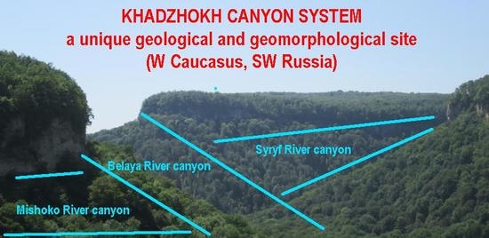
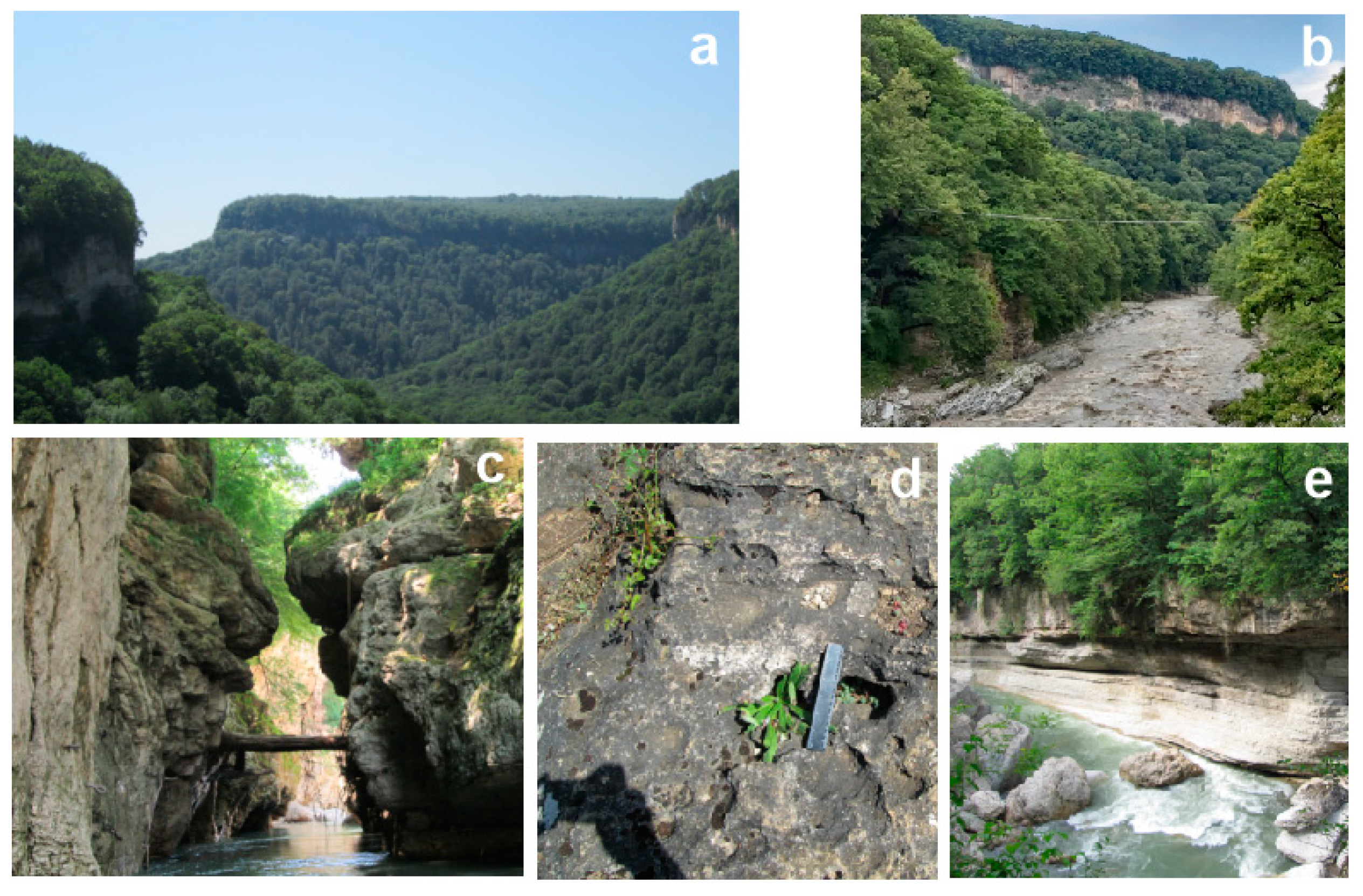
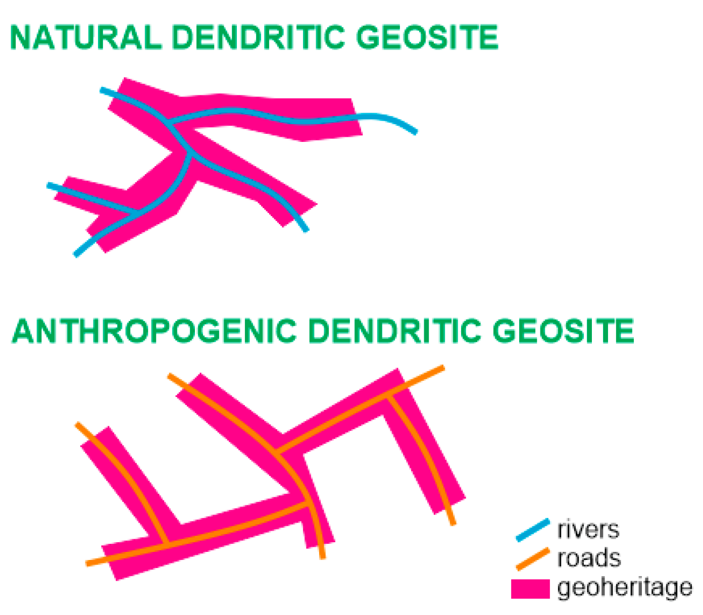
4.1. Geosite Outline

The Khadzhokh Canyon and its branches are proposed as a single geosite with the area of ~3 km2 that is located between Kamennomostskiy town in the north and Dakhovskaya Village in the south (Figure 2). The geoheritage value of this object was first established more than a decade ago [21] and then proven [5]. In fact, there are several canyons (Khadzhokh, Rufabgo, and Mishoko canyons, as well as some smaller stream valleys) in the study area, and, thus, it is better to label this geosite as the Khadzhokh Canyon System geosite.
The unique features are both numerous and diverse, and these can be attributed to several particular geoheritage types (see below). These features are exposed chiefly in natural outcrops along the rivers, roadcuttings, and cuesta scarps. Because of the diversity of unique phenomena, the entire geosite can be assigned to the complex type. Moreover, it is evident that the geomorphological features determine the very existence of this geosite. If so, the geomorphological features can be assigned to the dominant type (sensuRuban [5]), and the other types are non-dominant.

4.2. Dominant Geoheritage Type

The geomorphological type of geoheritage is represented in the study area by three large canyons, the KhadzhokhKlamm, and the Mishoko karst field. The Khadzhokh Canyon is the main landform dominating the study area (Figure 3a,b). Its eastern slope is known as the Una-Koz Range. The canyon has atypical U-shaped profile, and itis asymmetric in plan (Figure 2). Near the northern entrance, it is very narrow (just a few dozens of meters), and its slopes are steep, but relatively low. Near the southern entrance, the canyon is wide (up to 2 km), and its slopes are gentler, but very tall. This kind of asymmetry is fully determined by the local geological setting and, particularly, the relation of the landform to the Upper Jurassic monocline.
Two smaller canyons (Figure 2 and Figure 3a) are branches of the Khadzhokh Canyon, and these have been formed by an incision of the tributaries of the Belaya River. It cannot be excluded that their position is controlled by faults. The Rufabgo Canyon formed by the Syryf River has a length of ~3.5 km, width of 50–200 m, and depth of up to 500 m. Its slopes are very steep. This canyon has two levels (“steps”). The lower level is formed by the Triassic rocks (the Anisianlimestones and the Ladinian–Carnianflysch-like siliciclastics), and the upper level is formed by the Upper Jurassic limestones. The lower level is traced up to 2 km upstream from the mouth of the Syryf River, and the upper level is present everywhere. The Mishoko Canyon has comparable parameters, but it is shorter (~2 km).
The northern entrance to the Khadzhokh Canyon is so narrow (just 1–3 m somewhere) that looks like a fissure in the hard Upper Jurassic carbonates (Figure 3c). The slopes are either vertical or “hanging”. Natural bridges existed there in the historical times, but these are destroyed now. Such a landform can be defined with the German term “Klamm”. Although the latter is used very rarely in the professional literature [52], it is well suitable to describe the morphology of what is defined as the KhadzhokhKlamm [21].
Sub-horizontal surfaces of the Upper Jurassic carbonates exposed along the scarps of the Una-Koz Range are karstified extensively, especially near the Mishoko Canyon (Figure 2). Epi- and endokarstare very typical to Mountainous Adygeya [53], and the Mishoko karst field hosts numerous karren (Figure 3d) and small (up to 5 m in diameter) karst sinkholes that are often connected with cavities and even full-scale caves in the rock massif. The noted epikarst forms are quite common for the karst areas [54,55,56,57,58,59,60], and the Mishoko karst field provides a very typical representation of karstification of surfaces corresponding to gentle slopes of cuestas near their scarps.
Generally, the entire geomorphological type is characterized by certain diversity. The relevant features are often impressive by their size (Khadzhokh Canyon) or have an unusual view (KhadzhokhKlamm), but comparable landforms can be found in several if not many places of the Greater Caucasus, and they are unique only on the scale of the Western Caucasus. If so, the rank of this geoheritage type is regional. Geomorphological elements constitute the very essence of the analyzed geosite, and these are distributed everywhere within the latter. However, a concentration of unique geomorphological phenomena is registered in the northern part of the geosite (Figure 2).

4.3. Non-Dominant Geoheritage Types

The stratigraphical type of the Khadzhokh Canyon System geosite includes two important features. The first is one of the most complete successions of the Triassic of Russia. Lengthy exposures along the Belaya and Syryf rivers represent all stages of the Triassic, except for the Rhaetian [37,38]. The importance of this succession is diminished by two circumstances, namely the rarity of fossils and intense tectonic overprint by folds and faults. As a result, it is difficult to establish the age of some units and to correlate fragments of the same section. The second unique feature of this type is the stratotype section of the Kamennomostskaya Formation (Lower–Middle Callovian mixed siliciclastics and carbonates) in the natural outcrops of the Belaya River valley near the KhadzhokhKlamm (Figure 3e). This lithostratigraphical unit overlies the Upper Triassic shales with angular unconformity, and the latter represents the start of the new cycle of sedimentation. This section is not only important as a formation stratotype [39], but its uniqueness is also determined by exceptional condensation (the thickness is only ~7 m), which permits studying the stratigraphical patterns of this phenomenon [61,62,63]. Both the above-mentioned features are unique for the territory of the Western Caucasus and provide information on the regionalstratigraphical units. If so, the rank of the stratigraphical type of geoheritage is regional. Spatial distribution of this type is limited to the occurrence of the Triassic and Lower–Middle Callovian outcrops in the northern and central parts of the study area (Figure 2).
The paleontological type of geoheritage is represented locally by two fossil localities. The first is the above-mentioned stratotype section of the Kamennomostskaya Formation where marine invertebrates (ammonites, belemnites, bivalves, and brachiopods), fossil wood, and trace fossils have been found in significant amounts [39,64]. The most numerous are representatives of bivalve genera Chlamys and Radulopecten. The second locality is linked to the Khadzhokhquarry (see below) where numerous bivalves and brachiopods occur in the Oxfordianlimestones (their identification and description are yet to be done). Although both localities provide some important paleontological material, they have quite numerous analogsin Mountainous Adygeya [65], and, thus, the rank of the paleontological type of geoheritage is no more than local. The distribution of this type is limited to the northern part of the study area.
The paleogeographical type of geoheritage includes various features exposed in many places of the Khadzhokh Canyon System geosite. The Triassic sedimentary rocks represent a broad spectrum of depositional environments [37]. From them, the most interesting are the Ladinianflysch-like siliciclastics that mark an episode of strong deepening of the marine basin. On the global scale, the sea level was relatively moderate in the Ladinian, without any extraordinary rises [66]. Therefore, the deepening was a local/regional eventlimited to the Western Caucasus. The Jurassic deposits also differ facially. The Lower–Middle Jurassic dark-colored shales reflect accumulation in a deep, poorlyoxygenated basin [44], whereas the Upper Jurassic carbonates represent a big carbonate platform evolved on basin shelves [42,43]. Of special importance are coral reefs registered by Guo et al. [42] to the south of Kamennomostskiy. Although these paleogeographical features are notable, their uniqueness is restricted to the study area, and these have analogson the adjacent territories. If so, the only local rank can be assigned to the paleogeographical type of geoheritage. Nonetheless, this type is characterized by wide distribution within the geosite due to excellent exposure of the rocks representing the noted depositional environments.
The sedimentary type of geoheritage includes several features that contrast withtheir uniqueness. On the one hand, there are common sedimentary rocks like conglomerates, sandstones, shales, limestones, and dolostones. No specific features are linked to them, and, thus, these rocks cannot be judged unique even locally. On the other hand, the Khadzhokh Canyon and its branches host numerous megaclasts, i.e., clastic particles more than 1–2 m in diameter (Figure 3e and Figure 4a). Their accumulations are found in the Rufabgo Canyon and the KhadzhokhKlamm [45] (Figure 2). Some megaclasts also occur on the Khadzhokh Canyon slopes and at its bottom. A representative example is the Maiden’s Stone—a big megaclast with amaximum lengthof >10 m that is situated in the very midst of the Khadzhokh Canyon [45]. Inthe study area, the size of megaclasts differs from 1–2 m to >15–20 m. Their origin is linked to the collapse of huge blocks of Upper Jurassic carbonates from cuesta scarps.Megaclasts are in the focus of modern research, but these are rare features, often restricted to coastal zones [67,68,69,70,71,72,73,74]. Finding their significant accumulations (e.g., dozens of megaclasts form a specific sediment cover at the bottom of the Rufabgo Canyon) outside the coastal zone provides sedimentological evidence of outstanding importance for correctlyclassifying and genetic interpretation of megaclasts and megaclast deposits.Megaclasts of the Khadzhokh Canyon System geosite are unique on the scale of the Western Caucasus, and, thus, the rank of the sedimentary type of geoheritage is regional. This type is distributed widely within the geosite–megaclast accumulations are found in the Rufabgo Canyon and the KhadzhokhKlamm, and all three canyons host many megaclasts occurring individually (Figure 2).
The tectonic type of geoheritage includes two notable features, namely chevron folds in the Triassic deposits (Figure 4b) and the angular unconformity between the Norian and Callovian deposits. The folding is seen in continuous rock exposures along the Belaya, Syryf, and Mishoko rivers, and the unconformity is found in the KhadzhokhKlamm. Both features mark contraction phases in the regional evolution (the pre-Jurassic and mid-Jurassic tectonic events), but these can be also related to the Late Cenozoic growth of the Greater Caucasus orogen. Some important interpretations of these tectonic elements were proposed by Gaetani et al. [37], but further detailed investigations are necessary to decipher the origin and the age of the folding and the angular unconformity. These features are rare on the scale of the Western Caucasus, and, thus, the rank of the tectonic type of geoheritage is regional. The spatial distribution of the chevron folding is wide (the central part of the Khadzhokh Canyon and significant portions of the Rufabgo and Mishoko canyons).
The hydro(geo)logical type of geoheritage is represented, first of all, by the Rufabgo waterfalls of the Syryf River. The most known and accessible from them is the Shum waterfall with aheight of ~7 m (Figure 4c). Its scarp is formed by the hard Triassic limestones. There are also some other waterfalls on this river, its small tributaries, as well as on the Mishoko River. The Rufabgo waterfalls serve as an important tourist attraction in Mountainous Adygeya, but there are many other waterfalls in the Western Caucasus [75], and, thus, the rank of the hydro(geo)logical type of geoheritage is local. The spatial distribution of this type is limited to the tributaries of the Belaya River (Figure 2), the incision of which is not so strong to form a straight profile like the much bigger Belaya River. Inthe study area, there are other hydro(geo)logical objects like a small spring in the midst of the Khadzhokh Canyon and the Krasnoeartificial lake in the Khadzhokhquarry (Figure 4d). However, these are very ordinary objects, with very limited (if any) uniqueness. The activity of the Belaya River is also notable, but its effects are chiefly geomorphological and these are considered together with the dominant geoheritage type.
The coupled economical and geoexploration types of geoheritageconstitute the only Khadzhokhquarry. This quarry was operated in the mid-20th century for the purposes of Oxfordian limestone extraction (Figure 4d), and it is one of the biggest mining-related objects of the Republic of Adygeya. It also reflects the history of the regional exploration of geological resources. However, there are many other quarries in the Western Caucasus, and, thus, the rank of the Khadzhokhquarry is no more than local.

4.4. Other Geosite Characteristics

The Khadzhokh Canyon System geosite is highlycomplex because its unique features are attributed to nine geoheritage types co-occurring and intersecting in space. However, the ranks of the types are local (fivetypes) and regional (fourtypes). As for the entire geosite, it appears to be questionable whether it can be assigned to the global rank as earlier proposed [5]. On the one hand, the coincidence of multiple, essentially different unique features means that the uniqueness of the geosite is much higher than the uniqueness of its constituents taken separately. On the other hand, none feature is ranked higher than regional.There are three additional arguments in favor of high rank. First, some unique features are very typical and have analmost textbook view. These include the Khadzhokh Canyon itself, the megaclast accumulations, the chevron folding, and the waterfalls. Second, the Khadzhokh Canyon System geosite is distinguished by outstanding aesthetic properties recognized earlier [45,46,47] (see also the cover of the journal issue where [37] is published). Third, this geosite has become already an important (geo)tourist attraction. In regard to all these considerations, the rank of this geosite can be established as national. It should be stressed that this rank is established on the basis of the ranks of the geoheritage types related to the uniqueness (rarity) of the relevant features (see above) and the number of co-existing types (this approach is noted in [5]). Further procedures require an official listing of this geosite as a national geological heritage monument (this status is allowed by the Russian law), its delineation, and formal inclusion into the catalogsof the Russian protected areas. Thus, the present rank evaluation is a scientific proposal that forms the basis for the following steps.
The evaluation of the analyzed geosite by the criteria is given in Table 2. The relevant explanations are provided below. Generally, the mean score is high, which indicates the outstanding quality and importance of this geosite.
The anthropogenic pressure in the Khadzhokh Canyon System geosite is minimal, and it is linked to the growth of tourism infrastructure (construction of trails, guest houses, and parking) and road maintenance (slope stabilization requires some engineering solution). However, crowds of tourists change the meaning of the local scenery, which becomes less natural. On the one hand, such changes are inevitable, but, on the other hand, they may affect the aesthetic judgments of tourists based on scenery perception through the natural–unnatural frame [76,77].The accessibility of the geosite is perfect. First, the road stretches along the Khadzhokh Canyon on the right bank of the Belaya River (Figure 2). Second, there are well-established trails along the left bank of the Belaya River, the Rufabgo Canyon, the KhadzhokhKlamm, and in the southern vicinities of Kamennomostskiy. Many unique features can be accessed easily and examined in detail. The only exception is the Mishoko Canyon, which is accessible for only well-trained tourists. Some tourists can also find it difficult to reach the middle part of the Rufabgo Canyon.Additionally, panoramic views can be seen from the road inside the canyon, as well as from the cuesta ranges (Figure 4e). Two notable viewpoints are available on the border of the Khadzhokhquarry and the Mishoko karst field.
Understanding the essence of the majority of the unique features of the Khadzhokh Canyon System geosite requires professional knowledge of visitors or professional interpretation by speciallytrained guides, which is a kind of challenge for the local geotourism development. Nonetheless, this geosite is of extraordinary importance for different groups of visitors. Geoscientists can investigate various phenomena. Particularly, the study area provides material for deciphering the cuesta range development, Triassic stratigraphy, Callovian bivalve evolution, and megaclast nomenclature and genetic models. The probable occurrence of Late Paleozoic granitoids in the central part of this area, and the onyx localities in its northern part need further investigations; if proven, the presence of these features will permit to establish the igneous and mineralogical types of geoheritage. Geoeducators have used this geosite for many decades, andvisits there are included infield excursions of geoscience programs of several big universities of Russia. Finally, the tourist importance of this geosite and, particularly, the Rufabgo waterfalls and the KhadzhokhKlamm is very significant, as these are among the most popular attractions in the Mountainous Adygeya tourist destination.

5. Discussion and Conclusion

A really interesting characteristic of the Khadzhokh Canyon System geosite is its configuration in space (Figure 2) that cannot be described as either linear or areal. It is not linear because the unique features occur along several rivers as lengthy, interconnected stripes (Figure 5). It is not areal because the unique features do not occur on wide, gentle slopes of the cuesta ranges covered by dense vegetation. If so, it is sensible to propose a new category of geosites on the basis of the 2D “geometry” of the Khadzhokh Canyon System. The unique features are distributed chiefly along the Belaya River and its tributaries (Figure 5). This configuration resembles tree roots, and the word “dendritic” seems to be suitable to define it. This word is actively used in geoscience literatureto define drainage networks [78,79,80,81,82,83,84], deglaciation-related landforms [85,86,87,88,89], mineral aggregates [90,91,92], and some other phenomena. This word has been also applied to canyons [93], especially submarine canyons [94,95,96,97,98,99,100]. The main distinction of dendritic configuration is branching. The latter is typical for the only canyons of the study area, as well as to the distribution of the relevant geoheritage. In addition to the Khadzhokh Canyon and its two main branches, there are smaller valleys formed by tributaries of the Belaya, Syryf, and Mishokorivers. Although these are not lengthy, they often bear exposures of unique features such as the Triassic sedimentary rocks.
The evidence from the Khadzhokh Canyon System geosite permits to define dendritic geosites as big geosites where the geoheritage is distributed continuously via branching stripes (Figure 6). Three important remarks are necessary. First, these geosites should demonstrate integrity via the connection of unique features. Alternatively, these are the sets of smaller geosites (Figure 6). Second, unique features should present in all parts (branches) of a given dendritic network. For instance, it would be unreasonable to recognize any canyon as a dendritic geosite if only one branch of this canyon is a unique landform (e.g., because of its depth) or if geologicallyunique features concentrate in the only part (branch) of this canyon (Figure 6). Third, geoheritage should be restricted to narrow stripes (e.g., along river valleys); alternatively, this is an arealgeosite (Figure 6). The difference between areal and dendritic geosites is stressed above. However, it is not very strong because dendritic geosites may occupy a large area and the distance between the branches can be short in the case of a highlydense drainage network. That is why some dendritic geosites may be understood (if this is required by any research or practical purpose) as a kind of areal geosites. However, this is not the case of the Khadzhokh Canyon System geosite, particularly, because of certain simplicity of its shape (Figure 5). Such dendritic geosites can be also called branchinggeosites.
The geoheritage distribution in the Khadzhokh Canyon System geosite is continuous, and the geoheritage types co-occur and intersect in space (see above). Rather diverse unique features are found almost everywhere in this geosite (Figure 5). Moreover, there are features that occur in only “remote” parts of the geosite where the other features are not abundant; e.g., this is the case of theMishoko karst field. Undoubtedly, many dendritic geosites correspond to dendritic drainage networks with deep incision of valleys (either canyons or not), which allow continuous exposure of the rocks. A typical setting is characterized by Howard [93]. Such geosites are often (if not always)geomorphosites (sensu [49,101,102,103]) because of certain landform uniqueness, and these are often viewpoint geosites (sensu [18,104]) offering panoramic views from tall slopes (Figure 4e). However, dendritic geosites can have another origin too.Roadcuttings may expose unique geological features over significant distances [3,16]. Previous studies realized the importance of roadside geology in geoeducation [105] and geotourism [20]. If roads of a given area form a dendritic network and their cuttings exhibit precious geological information, a dendritic geosite can be recognized.In regard to the above-said, dendritic geosites can be both natural and anthropogenic (Figure 7). Anyway, it should be stressed that not all geosites located along rivers or roads are dendritic because drainage and road networks may differ substantially by their configuration. The density of river and road networks (if even these are just branching) also influences geosite shape.
As noted above, classification of geosites on the basis of their shape is chiefly of theoretical importance. Nonetheless, some practical implications are also evident. First, judging any given geosite as dendritic leads to its more precise description emphasison peculiar shape. Second, the distinction of areal and dendriticgeosites may be helpful for a better understanding of how a given geosite should be delineated officially (especially in regard to possible land-related disputes). For instance, the Khadzhokh Canyon System geosite requires official designation as a protected area (the Russian law allows this), and for this purpose, it should be characterized so to stress that the area with a special status will include only narrow stripes along the rivers, whereas the area between the branches doesnot require protection as it does not exhibit any geoheritage. Third, the label “dendritic” may be useful for geotourism practitioners, as it provides a clear idea of how geo-routes should be planned within such a geosite, i.e., these routes should follow rivers or roads.
Conclusively, the Khadzhokh Canyon System geosite in the Western Caucasus is a complex, nationallyranked geosite. Its unique features are assigned to nine geoheritage types, and finding some other types in the future is not excluded. Continuous distribution of geoheritage along the branching canyon system allows recognition of a novel category, namely dendritic geosites. Further investigations in the Khadzhokh Canyon and its vicinities should be aimed at finding the evidence of additional, potentially unique features. More generally, dendritic geosites have to be found in the other regions of the world and compared to the Khadzhokh Canyon System geositeof the Western Caucasus.

Author Contributions

Conceptualization, D.A.R.; methodology, A.V.M. and D.A.R.; investigation, A.V.M. and D.A.R.; writing—original draft preparation, D.A.R.; writing—review and editing, D.A.R. and V.A.E. All authors have read and agreed to the published version of the manuscript.

Funding

This research received no external funding.

Acknowledgments

The authors gratefully thank the journal editors and the reviewers for valuable recommendations and support.

Conflicts of Interest

The authors declare no conflict of interest.

References

  1. Brilha, J. Inventory and quantitative assessment of geosites and geodiversity sites: A review. Geoheritage 2016, 8, 119–134. [Google Scholar] [CrossRef] [Green Version]
  2. Henriques, M.H.; Pena dos Reis, R.; Brilha, J.; Mota, T. Geoconservation as an Emerging Geoscience. Geoheritage 2011, 3, 117–128. [Google Scholar] [CrossRef] [Green Version]
  3. Prosser, C.; Murphy, M.; Larwood, J. Geological Conservation: A Guide to Good Practice; English Nature: Peterborough, UK, 2006. [Google Scholar]
  4. Reynard, E.; Brilha, J. (Eds.) Geoheritage: Assessment, Protection, and Management; Elsevier: Amsterdam, The Netherlands, 2018. [Google Scholar]
  5. Ruban, D.A. Quantification of geodiversity and its loss. Proc. Geol. Assoc. 2010, 121, 326–333. [Google Scholar] [CrossRef]
  6. Štrba, L.; Rybar, P.; Balaz, B.; Molokac, M.; Hvizdak, L.; Krsak, B.; Lukac, M.; Muchova, L.; Tometzova, D.; Ferencikova, J. Geosite assessments: Comparison of methods and results. Curr. Issues Tour. 2015, 18, 496–510. [Google Scholar] [CrossRef]
  7. Wimbledon, W.A.P.; Smith-Meyer, S. (Eds.) Geoheritage in Europe and its conservation; ProGEO: Oslo, Norway, 2012. [Google Scholar]
  8. Brilha, J.; Gray, M.; Pereira, D.I.; Pereira, P. Geodiversity: An integrative review as a contribution to the sustainable management of the whole of nature. Environ. Sci. Policy 2018, 86, 19–28. [Google Scholar] [CrossRef] [Green Version]
  9. Ruban, D.A.; Tiess, G.; Sallam, E.S.; Ponedelnik, A.A.; Yashalova, N.N. Combined mineral and geoheritage resources related to kaolin, phosphate, and cement production in Egypt: Conceptualization, assessment, and policy implications. Sustain. Environ. Res. 2018, 28, 454–461. [Google Scholar] [CrossRef]
  10. Dowling, R.; Newsome, D. (Eds.) Handbook of Geotourism; Edward Elgar: Cheltenham, UK, 2018. [Google Scholar]
  11. Hose, T.A. 3G’s for Modern Geotourism. Geoheritage 2012, 4, 7–24. [Google Scholar] [CrossRef]
  12. Olafsdottir, R.; Tverijonaite, E. Geotourism: A Systematic Literature Review. Geosciences 2018, 8, 234. [Google Scholar] [CrossRef] [Green Version]
  13. Bradbury, J. A keyed classification of natural geodiversity for land management and nature conservation purposes. Proc. Geol. Assoc. 2014, 125, 329–349. [Google Scholar] [CrossRef]
  14. Bruschi, V.M.; Cendrero, A. Geosite evaluation; can we measure intangible values? Alp. Mediterr. Quat. 2005, 18, 293–306. [Google Scholar]
  15. Fernández, M.P.; Timón, D.L.; Marín, R.G. Geosites Inventory in the Geopark Villuercas-Ibores-Jara (Extremadura, Spain): A Proposal for a New Classification. Geoheritage 2014, 6, 17–27. [Google Scholar] [CrossRef]
  16. Habibi, T.; Ponedelnik, A.A.; Yashalova, N.N.; Ruban, D.A. Urban geoheritage complexity: Evidence of a unique natural resource from Shiraz city in Iran. Resour. Policy 2018, 59, 85–94. [Google Scholar] [CrossRef]
  17. Miljkovic, D.; Božic, S.; Miljkovic, L.; Markovic, S.B.; Lukic, T.; Jovanovic, M.; Bjelajac, D.; Vasiljevc, D.A.; Vujicic, M.D.; Ristanovic, B. Geosite Assessment Using Three Different Methods; A Comparative Study of the Krupaja and the Žagubica Springs-Hydrological Heritage of Serbia. Open Geosci. 2018, 10, 192–208. [Google Scholar] [CrossRef]
  18. Migoń, P.; Pijet-Migoń, E. Viewpoint geosites—Values, conservation and management issues. Proc. Geol. Assoc. 2017, 128, 511–522. [Google Scholar] [CrossRef]
  19. Ruban, D.A. Geological Heritage of the Anthropocene Epoch—A Conceptual Viewpoint. Heritage 2020, 3, 19–28. [Google Scholar] [CrossRef] [Green Version]
  20. Štrba, L.; Baláž, B.; Lukác, M. Roadside geotourism—An alternative approach to geotourism. e-Rev. Tour. Res. 2016, 13, 589–609. [Google Scholar]
  21. Ruban, D.A.; Pugachev, V.I. The Khadzhokhsky canyon and the Granitnoye gorge (Adygeia, Russia) as geological natural monuments. Geogr. Nat. Resour. 2008, 29, 50–53. [Google Scholar] [CrossRef]
  22. Ahnert, F. The influence of Pleistocene climates upon the morphology of cuesta scarps on the Colorado plateau. Ann. Assoc. Am. Geogr. 1960, 50, 139–156. [Google Scholar] [CrossRef]
  23. Barlow, J. Rock creep and the development of the Niagara Cuesta. Earth Surf. Process. Landf. 2002, 27, 1125–1135. [Google Scholar] [CrossRef]
  24. Davis, W.M. The Drainage of Cuestas. Proc. Geol. Assoc. 1899, 16, 75–93. [Google Scholar] [CrossRef]
  25. Duszynski, F.; Migoń, P.; Strzelecki, M.C. Escarpment retreat in sedimentary tablelands and cuesta landscapes—Landforms, mechanisms and patterns. Earth-Sci. Rev. 2019, 196, 102890. [Google Scholar] [CrossRef]
  26. Hübscher, C.; Borowski, C. Seismic evidence for fluid escape from Mesozoic cuesta type topography in the Skagerrak. Mar. Pet. Geol. 2006, 23, 17–28. [Google Scholar] [CrossRef]
  27. Jungerius, P.D.; Van Zon, H.J.M. The formation of the Lias cuesta (Luxembourg) in the light of present-day erosion processes operating on forest soils. Geogr. Ann. Ser. A 1982, 64, 127–140. [Google Scholar] [CrossRef]
  28. Peterek, A.; Schröder, B. Geomorphologie evolution of the cuesta landscapes around the Northern Franconian Alb—Review and synthesis. Z. Für Geomorphol. 2010, 54, 305–345. [Google Scholar] [CrossRef]
  29. Pinheiro, M.R.; Queiroz Neto, J.P.D. From the semiarid landscapes of southwestern USA to the wet tropical zone of southeastern Brazil: Reflections on the development of cuestas, pediments, and talus. Earth-Sci. Rev. 2017, 172, 27–42. [Google Scholar] [CrossRef]
  30. Schmidt, K.-H.; Meitz, P. Cuesta scarps on the Colorado Plateau, USA—Lithological and climatic control in different altitudinal belts. Erde 2000, 131, 181–204. [Google Scholar]
  31. Ward, D.J. Dip, layer spacing, and incision rate controls on the formation of strike valleys, cuestas, and cliffbands in heterogeneous stratigraphy. Lithosphere 2019, 11, 697–707. [Google Scholar] [CrossRef] [Green Version]
  32. Adamia, S.; Zakariadze, G.; Chkhotua, T.; Sadradze, N.; Tsereteli, N.; Chabukiani, A.; Gventsadze, A. Geology of the Caucasus: A review. Turk. J. Earth Sci. 2011, 20, 489–544. [Google Scholar]
  33. Rolland, Y. Caucasus collisional history: Review of data from East Anatolia to West Iran. Gondwana Res. 2017, 49, 130–136. [Google Scholar] [CrossRef]
  34. van Hinsbergen, J.J.; Torsvik, T.H.; Schmid, S.M.; Matenco, L.C.; Maffione, M.; Vissers, R.L.M.; Gürer, D.; Spakman, W. Orogenic architecture of the Mediterranean region and kinematic reconstruction of its tectonic evolution since the Triassic. Gondwana Res. 2020, 81, 79–229. [Google Scholar] [CrossRef]
  35. Vasey, D.; Cowgill, E.; Roeske, S.M.; Niemi, N.A.; Godoladze, T.; Skhirtladze, I.; Gogoladze, S. Evolution of the Greater Caucasus Basement and Formation of the Main Caucasus Thrust, Georgia. Tectonics 2020, 39, e2019TC005828. [Google Scholar] [CrossRef]
  36. Yin, A. Cenozoic tectonic evolution of Asia: A preliminary synthesis. Tectonophysics 2010, 488, 293–325. [Google Scholar] [CrossRef]
  37. Gaetani, M.; Garzanti, E.; Poline, R.; Kiricko, Y.; Korsakhov, S.; Cirilli, S.; Nicora, A.; Rettori, R.; Larghi, C.; Bucefalo Palliani, R. Stratigraphic evidence for Cimmerian events in NW Caucasus (Russia). Bull. De La Société Géologique De Fr. 2005, 176, 283–299. [Google Scholar] [CrossRef]
  38. Ruban, D.A.; Zerfass, H.; Pugatchev, V.I. Triassic synthems of southern South America (southwestern Gondwana) and the Western Caucasus (the northern Neotethys), and global tracing of their boundaries. J. South Am. Earth Sci. 2009, 28, 155–167. [Google Scholar] [CrossRef] [Green Version]
  39. Rostovtsev, K.O.; Agaev, V.B.; Azarian, N.R.; Babaev, R.G.; Beznosov, N.V.; Hassanov, N.A.; Zesashvili, V.I.; Lomize, M.G.; Paitschadze, T.A.; Panov, D.I.; et al. Yura Kavkaz; Nauka: St. Petersburg, Russia, 1992. (In Russian) [Google Scholar]
  40. Adamia, S.; Alania, V.; Chabukiani, A.; Kutelia, Z.; Sadradze, N. Great Caucasus (Cavcasioni): A Long-lived North-Tethyan Back-Arc Basin. Turk. J. Earth Sci. 2011, 20, 611–628. [Google Scholar]
  41. Ershova, A.V.; Brunet, M.-F.; Nikishin, A.M.; Bolotov, S.N.; Nazarevich, B.P.; Korotaev, M.V. Northern Caucasus basin: Thermal history and synthesis of subsidence models. Sediment. Geol. 2003, 156, 95–118. [Google Scholar] [CrossRef]
  42. Guo, L.; Vincent, S.J.; Lavrishchev, V. Upper Jurassic Reefs from the Russian Western Caucasus: Implications for the Eastern Black Sea. Turk. J. Earth Sci. 2011, 20, 629–653. [Google Scholar]
  43. Kuznetsov, V.G. Late Jurassic—Early Cretaceous carbonate platform in the northern Caucasus and Precaucasus. Am. Assoc. Pet. Geol. Mem. 1993, 56, 455–463. [Google Scholar]
  44. Jasamanov, N.A. Landshaftno-klimatitchieskije uslovija jury, mela i paleogena Juga SSSR; Nedra: Moskva, Russia, 1978. (In Russian) [Google Scholar]
  45. Lubova, K.A.; Zayats, P.P.; Ruban, D.A.; Tiess, G. Megaclasts in geoconservation: Sedimentological questions, anthropogenic influence, and geotourism potential. Geologos 2013, 19, 321–335. [Google Scholar] [CrossRef]
  46. Mikhailenko, A.V.; Ruban, D.A. Geo-Heritage Specific Visibility as an Important Parameter in Geo-Tourism Resource Evaluation. Geosciences 2019, 9, 146. [Google Scholar] [CrossRef] [Green Version]
  47. Mikhailenko, A.V.; Nazarenko, O.V.; Ruban, D.A.; Zayats, P.P. Aesthetics-based classification of geological structures in outcrops for geotourism purposes: A tentative proposal. Geologos 2017, 23, 45–52. [Google Scholar] [CrossRef] [Green Version]
  48. Fuertes-Gutiérrez, I.; Fernández-Martínez, E. Geosites Inventory in the Leon Province (Northwestern Spain): A Tool to Introduce Geoheritage into Regional Environmental Management. Geoheritage 2010, 2, 57–75. [Google Scholar] [CrossRef]
  49. Mucivuna, V.C.; Reynard, E.; Garcia, M.G.M. Geomorphosites Assessment Methods: Comparative Analysis and Typology. Geoheritage 2019, 11, 1799–1815. [Google Scholar] [CrossRef]
  50. Sinnyovsky, D.; Sachkov, D.; Tsvetkova, I.; Atanasova, N. Geomorphosite Characterization Method for the Purpose of an Aspiring Geopark Application Dossier on the Example of Maritsa Cirque Complex in Geopark Rila, Rila Mountain, SW Bulgaria. Geoheritage 2020, 12, 26. [Google Scholar] [CrossRef]
  51. Warowna, J.; Zglobicki, W.; Kolodynska-Gawrysiak, R.; Gajek, G.; Gawrysiak, L.; Telecka, M. Geotourist values of loess geoheritage within the planned Geopark Malopolska Vistula River Gap, E Poland. Quat. Int. 2016, 399, 46–57. [Google Scholar] [CrossRef]
  52. Scheidegger, A.E.; Hantke, R. On the genesis of river gorges. Trans. Jpn. Geomorphol. Union 1994, 15, 91–110. [Google Scholar]
  53. Lozovoj, S.P. Lagonakskoe nagor’e; Krasnodarskoe knizhnoe izdatel’stvo: Krasnodar, Russia, 1984. (In Russian) [Google Scholar]
  54. Bakalowicz, M. Epikarst Processes. Treatise Geomorphol. 2013, 6, 164–171. [Google Scholar]
  55. Jones, W.K. Physical structure of the epikarst. Acta Carsologica 2013, 42, 311–314. [Google Scholar] [CrossRef]
  56. Ginés, A.; Knez, M.; Slabe, T.; Dreybrodt, W. (Eds.) Karst rock features: Karren scuplturing; Karst Research Institute ZRC SAZU: Ljubljana, Slovenia, 2009. [Google Scholar]
  57. Veress, M. Morphology and solution relationships of three karren slopes in different environments (Totes Gebirge, Eastern Alps). Z. Für Geomorphol. 2012, 56, 47–62. [Google Scholar] [CrossRef]
  58. Veress, M. The karren and karren formation of bare slopes. Earth-Sci. Rev. 2019, 188, 272–290. [Google Scholar] [CrossRef]
  59. Veress, M.; Péntek, K. Theoretical model of surface karstic processes. Z. Für Geomorphol. 1996, 40, 461–476. [Google Scholar]
  60. Williams, P.W. The role of the epikarst in karst and cave hydrogeology: A review. Int. J. Speleol. 2008, 37, 1–10. [Google Scholar] [CrossRef] [Green Version]
  61. Alberti, M.; Fürsich, F.T.; Pandey, D.K. Deciphering condensed sequences: A case study from the Oxfordian (Upper Jurassic) Dhosa Oolite member of the Kachchh Basin, western India. Sedimentology 2013, 60, 574–598. [Google Scholar] [CrossRef]
  62. Föllmi, K.B. Sedimentary condensation. Earth-Sci. Rev. 2016, 152, 143–180. [Google Scholar]
  63. Gómez, J.J.; Fernández-López, S. Condensation processes in shallow platforms. Sediment. Geol. 1994, 92, 147–159. [Google Scholar] [CrossRef] [Green Version]
  64. Dzyuba, O.S.; Goryacheva, A.A.; Ruban, D.A.; Gnezdilova, V.V.; Zayats, P.P. New data on Callovian (Middle Jurassic) belemnites and palynomorphs from the Northwestern Caucasus, southwest Russia. Geologos 2016, 22, 49–59. [Google Scholar] [CrossRef] [Green Version]
  65. Vorob’ev, I.E. Poisk iskopaemykh na Severo-Zapadnom Kavkaze. Krasnodarskij kraj i Respublika Adygeja; KO RosGeo: Krasnodar, Russia, 2014. (In Russian) [Google Scholar]
  66. Haq, B.U. Triassic Eustatic Variations Reexamined. GSA Today 2018, 28, 4–9. [Google Scholar] [CrossRef] [Green Version]
  67. Blair, T.C.; McPherson, J.G. Grain-size and textural classification of coarse sedimentary particles. J. Sediment. Res. 1999, 69, 6–19. [Google Scholar] [CrossRef]
  68. Blott, S.J.; Pye, K. Particle size scales and classification of sediment types based on particle size distributions: Review and recommended procedures. Sedimentology 2012, 59, 2071–2096. [Google Scholar] [CrossRef]
  69. Cox, R.; Lopes, W.A.; Jahn, K.L. Quantitative roundness analysis of coastal boulder deposits. Mar. Geol. 2018, 396, 114–141. [Google Scholar] [CrossRef]
  70. Dewey, J.F.; Ryan, P.D. Storm, rogue wave, or tsunami origin for megaclast deposits in western Ireland and North Island, New Zealand? Proc. Natl. Acad. Sci. USA 2017, 114, E10639–E10647. [Google Scholar] [CrossRef] [PubMed] [Green Version]
  71. Johnson, M.E.; Ledesma-Vazquez, J.; Guardado-France, R. Coastal Geomorphology of a Holocene Hurricane Deposits on a Pleistocene Marine Terrace from Isla Carmen (Baja California Sur, Mexico). J. Mar. Sci. Eng. 2018, 6, 108. [Google Scholar] [CrossRef] [Green Version]
  72. Johnson, M.E.; Guardado-France, R.; Johnson, E.M.; Ledesma-Vazquez, J. Geomorphology of a Holocene Hurricane Deposit Eroded from Rhyolite Sea Cliffs on Ensenada Almeja (Baja California Sur, Mexico). J. Mar. Sci. Eng. 2019, 7, 193. [Google Scholar] [CrossRef] [Green Version]
  73. Scheffers, A.; Scheffers, S.; Kelletat, D.; Browne, T. Wave-emplaced coarse debris and megaclasts in Ireland and Scotland: Boulder transport in a high-energy littoral environment. J. Geol. 2009, 117, 553–573. [Google Scholar] [CrossRef]
  74. Terry, J.P.; Goff, J. Megaclasts: Proposed revised nomenclature at the coarse end of the Udden-Wentworth grain-size scale for sedimentary particles. J. Sediment. Res. 2014, 84, 192–197. [Google Scholar] [CrossRef]
  75. Trepet, S.A. Vodopady Rufabgo; Kubanskoe knizhnoe izdatel’stvo: Krasnodar, Russia, 2013. (In Russian) [Google Scholar]
  76. Kirillova, K.; Fu, X.; Lehto, X.; Cai, L. What makes a destination beautiful? Dimensions of tourist aesthetic judgment. Tour. Manag. 2014, 42, 282–293. [Google Scholar] [CrossRef]
  77. Schirpke, U.; Tappeiner, G.; Tasser, E.; Tappeiner, U. Using conjoint analysis to gain deeper insights into aesthetic landscape preferences. Ecol. Indic. 2019, 96, 202–212. [Google Scholar] [CrossRef]
  78. Alapati, U.; Jampani, M.; Sukhtankar, R.K. Geomorphic response of the river basin drainage in seismically active regions of India. Environ. Earth Sci. 2019, 17, 532. [Google Scholar] [CrossRef]
  79. Bouramtane, T.; Yameogo, S.; Touzani, M.; Tiouiouine, A.; El Janati, M.; Ouardi, J.; Kacimi, I.; Valles, V.; Barbiero, L. Statistical approach of factors controlling drainage network patterns in arid areas. Application to the Eastern Anti Atlas (Morocco). J. Afr. Earth Sci. 2020, 162, 103707. [Google Scholar] [CrossRef]
  80. Jarvis, R.S. New measure of the topologic structure of dendritic drainage networks. Water Resour. Res. 1972, 8, 1265–1271. [Google Scholar] [CrossRef]
  81. Jung, K.; Marpu, P.R.; Ouarda, T.B.M.J. Impact of river network type on the time of concentration. Arab. J. Geosci. 2017, 10, 546. [Google Scholar] [CrossRef]
  82. Khan, N. Tectonic geomorphology and structural architecture of eastern Sulaiman Fold Thrust Belt (SFTB) and adjacent Sulaiman Foredeep (SF), northwest Pakistan. Geomorphology 2019, 343, 145–167. [Google Scholar] [CrossRef]
  83. Naegeli, K.; Lovell, H.; Zemp, M.; Benn, D.I. Dendritic subglacial drainage systems in cold glaciers formed by cut-and-closure processes. Geogr. Ann. Ser. A Phys. Geogr. 2014, 96, 591–608. [Google Scholar] [CrossRef] [Green Version]
  84. Seo, Y.; Seo, Y.-H.; Kim, Y.-O. Behavior of a fully-looped drainage network and the corresponding dendritic networks. Water 2015, 7, 1291–1305. [Google Scholar] [CrossRef] [Green Version]
  85. Brennand, T.A. Deglacial meltwater drainage and glaciodynamics: Inferences from Laurentide eskers, Canada. Geomorphology 2000, 32, 263–293. [Google Scholar] [CrossRef]
  86. Delaney, C. Sedimentology of a glaciofluvial landsystem, Lough Ree area, Central Ireland: Implications for ice margin characteristics during Devensian deglaciation. Sediment. Geol. 2002, 149, 111–126. [Google Scholar] [CrossRef]
  87. Sambrook Smith, G.H.; Glasser, N.F. Late Devensian ice sheet characteristics: A palaeohydraulic approach. Geol. J. 1998, 33, 149–158. [Google Scholar] [CrossRef]
  88. Trommelen, M.S.; Ross, M.; Campbell, J.E. Glacial terrain zone analysis of a fragmented paleoglaciologic record, southeast Keewatin sector of the Laurentide Ice Sheet. Quat. Sci. Rev. 2012, 40, 1–20. [Google Scholar] [CrossRef]
  89. Trottier, A.-P.; Lajeunesse, P.; Gagnon-Poiré, A.; Francus, P. Morphological signatures of deglaciation and postglacial sedimentary processes in a deep fjord-lake (Grand Lake, Labrador). Earth Surf. Process. Landf. 2020, 45, 928–947. [Google Scholar] [CrossRef]
  90. Berdnikov, N.V.; Nevstruev, V.G.; Saksin, B.G. Genetic Aspects of the Noble-Metal Mineralization at the Poperechnoe Deposit, Lesser Khingan, Russia. Russ. J. Pac. Geol. 2017, 11, 421–435. [Google Scholar] [CrossRef]
  91. Koski, R.A.; Clague, D.A.; Oudin, E. Mineralogy and chemistry of massive sulfide deposits from the Juan de Fuca Ridge. Geol. Soc. Am. Bull. 1984, 95, 930–945. [Google Scholar] [CrossRef]
  92. Manuella, F.C. Vein mineral assemblage in partially serpentinized peridotite xenoliths from Hyblean Plateau (south-eastern Sicily, Italy). Period. Di Mineral. 2011, 80, 247–266. [Google Scholar]
  93. Howard, A.D. Simulation modeling and statistical classification of escarpment planforms. Geomorphology 1995, 12, 187–214. [Google Scholar] [CrossRef] [Green Version]
  94. Aslam, T.; Hall, R.A.; Dye, S.R. Internal tides in a dendritic submarine canyon. Prog. Oceanogr. 2018, 169, 20–32. [Google Scholar] [CrossRef]
  95. Hall, R.A.; Aslam, T.; Huvenne, V.A.I. Partly standing internal tides in a dendritic submarine canyon observed by an ocean glider. Deep-Sea Res. Part I Oceanogr. Res. Pap. 2017, 126, 73–84. [Google Scholar] [CrossRef] [Green Version]
  96. Porter-Smith, R.; Lyne, V.D.; Kloser, R.J.; Lucieer, V.L. Catchment-based classification of Australia’s continental slope canyons. Mar. Geol. 2012, 303–306, 183–192. [Google Scholar] [CrossRef]
  97. Rydningen, T.A.; Laberg, J.S.; Kolstad, V. Seabed morphology and sedimentary processes on high-gradient though mouth fans offshore Troms, northern Norway. Geomorphology 2015, 246, 205–219. [Google Scholar] [CrossRef] [Green Version]
  98. Stewart, H.A.; Davies, J.S.; Guinan, J.; Howell, K.L. The Dangeard and Explorer canyons, South Western Approaches UK: Geology, sedimentology and newly discovered cold-water coral mini-mounds. Deep-Sea Res. Part II Top. Stud. Oceanogr. 2014, 104, 230–244. [Google Scholar] [CrossRef] [Green Version]
  99. T aylor, B.; Smoot, N.C. Morphology of Bonin fore-arc submarine canyons. Geology 1984, 12, 724–727. [Google Scholar] [CrossRef]
  100. Vachtman, D.; Mitchell, N.C.; Gawthorpe, R. Morphologic signatures in submarine canyons and gullies, central USA Atlantic continental margins. Mar. Pet. Geol. 2013, 41, 250–263. [Google Scholar] [CrossRef]
  101. Kubalíková, L.; Kirchner, K. Geosite and Geomorphosite Assessment as a Tool for Geoconservation and Geotourism Purposes: A Case Study from Vizovická vrchovina Highland (Eastern Part of the Czech Republic). Geoheritage 2016, 8, 5–14. [Google Scholar] [CrossRef]
  102. Pereira, P.; Pereira, D. Methodological guidelines for geomorphosite assessment. Geomorphol. Relief Process. Environ. 2010, 2, 215–222. [Google Scholar] [CrossRef] [Green Version]
  103. Reynard, E.; Coratza, P.; Hobléa, F. Current Research on Geomorphosites. Geoheritage 2016, 8, 1–3. [Google Scholar] [CrossRef] [Green Version]
  104. Mikhailenko, A.V.; Ruban, D.A. Environment of Viewpoint Geosites: Evidence from the Western Caucasus. Land 2019, 8, 93. [Google Scholar] [CrossRef] [Green Version]
  105. Jolley, A.; Kennedy, B.M.; Brogt, E.; Hampton, S.J.; Fraser, L. Are we there yet? Sense of place and the student experience on roadside and situated geology field trips. Geosphere 2018, 14, 651–667. [Google Scholar] [CrossRef] [Green Version]
Figure 1. Geographical location of the study area (the view provided by Google Earth Engine).
Geosciences 10 00181 g001
Figure 2. Geomorphological and geological elements of the study area.
Geosciences 10 00181 g002
Figure 3. Geoheritage of the study area (part 1): a—general view of the Khadzhokh Canyon and its branches, b—the central part of the Khadzhokh Canyon, c—the KhadzhokhKlamm, d—minor epikarst features of the Mishoko karst field, e—the Callovian deposits and megaclasts near the KhadzhokhKlamm.
Geosciences 10 00181 g003
Figure 4. Geoheritage of the study area (part 2): a—megaclasts of the Rufabgo Canyon (D.A.R. stays for scale), b—chevron folds in the Triassic deposits, c—the Shum waterfall, d—the Khadzhokh quarry and the Krasnoe artificial lake, e—panoramic view of the Mishoko Canyon demonstrating the aesthetic potential of this point to (geo)tourists (A.V.M. stays for scale).
Geosciences 10 00181 g004
Figure 5. Distribution of geoheritage types in the Khadzhokh Canyon System geosite.
Geosciences 10 00181 g005
Figure 6. Differences of dendritic geosites from the other categories of geosites.
Geosciences 10 00181 g006
Figure 7. Dendritic geosites of different origin.
Geosciences 10 00181 g007
Table 1. Criteria used for geositeevaluation in this study.
CriteriaGeosite CharacteristicsScores
Complexity1–2 geoheritage types1
3–5 geoheritage types2
>5 geoheritage types3
ExposureSmall, dispersed outcrops 1
Fragmentary outcrops2
Lengthy outcrops3
Anthropogenic pressureSignificant modification/big amount of garbage1
Small modification/small amount of garbage2
Absent3
AccessibilityGeosite location in remote place, special training is required1
Special training is required for visiting some outcrops2
All parts of geosite are easily accessible3
DifficultytounderstandOnly professional knowledge is required1
Some professional knowledge is required2
Clear to all people3
Aesthetic propertiesNothing special comparing to the surrounding landscape1
Some peculiar features (unusual color of rocks or landform shapes, etc.)2
Aesthetically distinct features, panoramic views, etc.3
Importance to scientistsLow1
Medium2
High3
Importance to educatorsLow1
Medium2
High3
Important to touristsLow1
Medium2
High3
Table 2. The Khadzhokh Canyon System geosite evaluation.
CriteriaGeosite CharacteristicsScores
>5 geoheritage types3
ExposureLengthy outcrops3
Anthropogenic pressureSmall modification/small amount of garbage2
AccessibilitySpecial training is required for visiting some outcrops2
Difficulty-to-understandSome professional knowledge is required2
Aesthetic propertiesAesthetically distinct features, panoramic views, etc.3
Importance to scientistsMedium2
Importance to educatorsHigh3
Important to touristsHigh3
MEAN2.6

