Spatial Landslide Risk Assessment at Phuentsholing, Bhutan
Abstract
1. Introduction
2. Study Area
3. Data Used
4. Method
5. Results and Discussions
5.1. Landslide Hazard Assesment
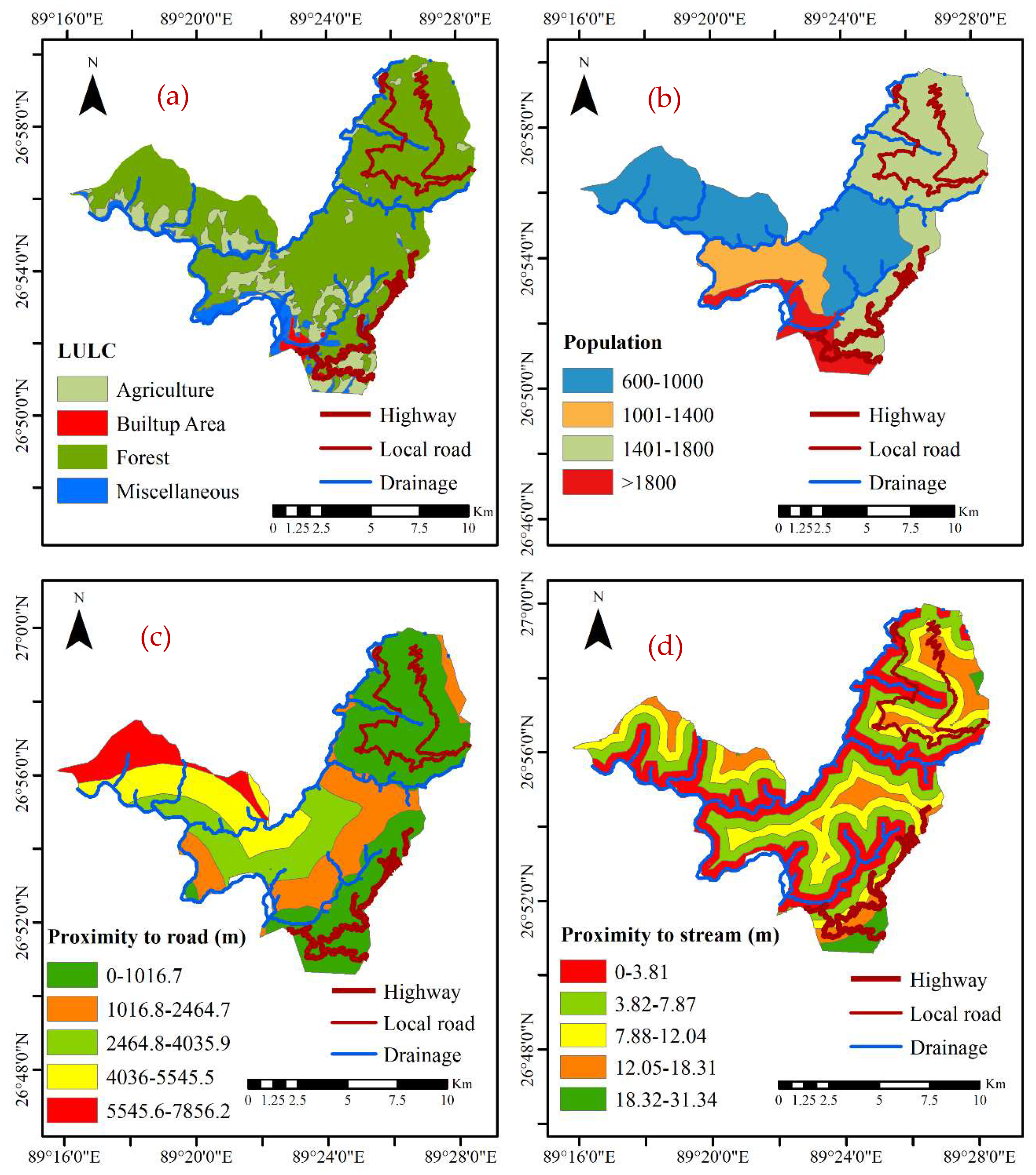
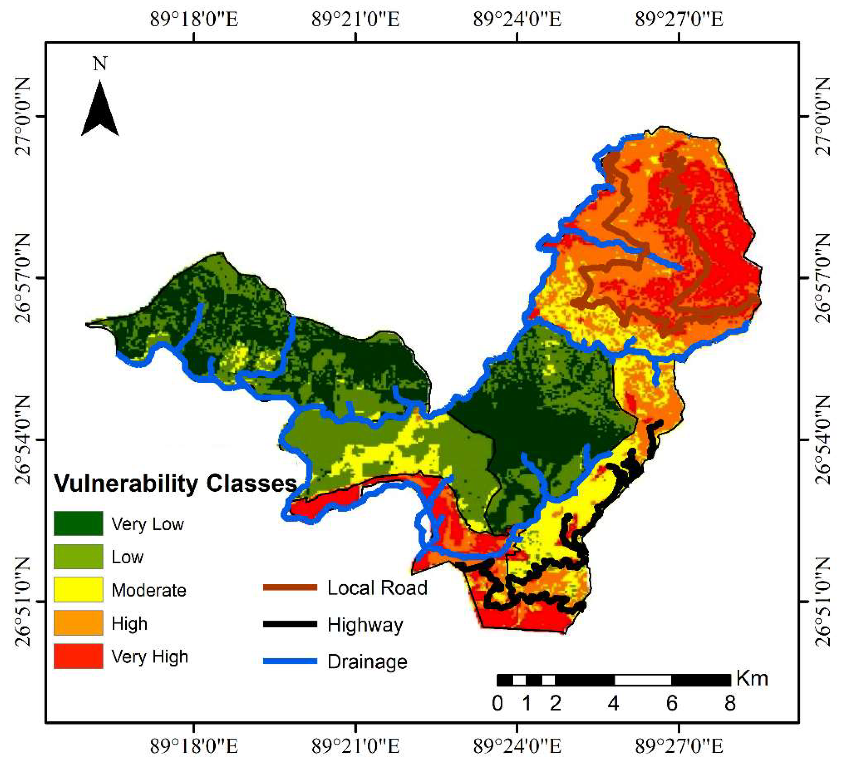
5.2. Landslide Vulnerability Assessment
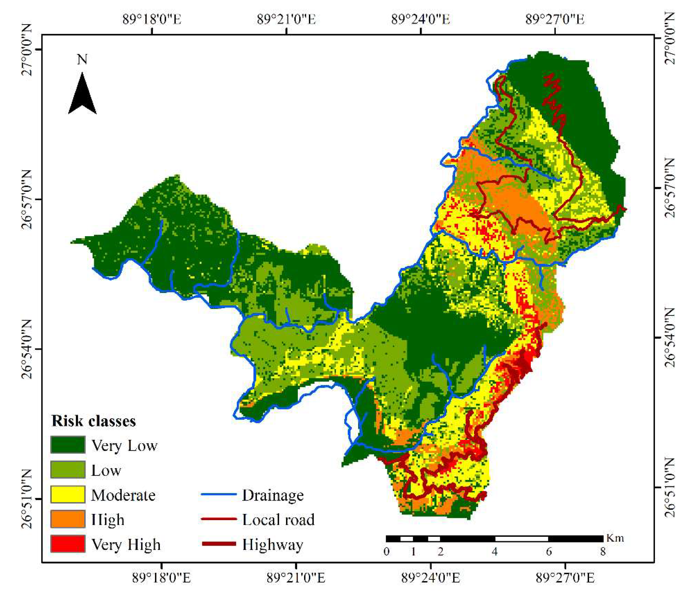
5.3. Landslide Risk Assessment
6. Conclusions
Author Contributions
Funding
Acknowledgments
Conflicts of Interest
References
- Petley, D. Global patterns of loss of life from landslides. Geology 2012, 40, 927–930. [Google Scholar] [CrossRef]
- Froude, M.J.; Petley, D.N. Global fatal landslide occurrence from 2004 to 2016. Nat. Hazards Earth Syst. Sci. 2018, 18, 2161–2181. [Google Scholar] [CrossRef]
- Dikshit, A.; Sarkar, R.; Pradhan, B.; Jena, R.; Drukpa, D.; Alamri, A. Temporal Probability Assessment and Its Use in Landslide Susceptibility Mapping for Eastern Bhutan. Water 2020, 12, 267. [Google Scholar] [CrossRef]
- Dikshit, A.; Satyam, N. Probabilistic rainfall thresholds in Chibo, India: Estimation and validation using monitoring system. J. Mt. Sci. 2019, 16, 870–883. [Google Scholar] [CrossRef]
- Segoni, S.; Piciullo, L.; Gariano, S.L. A review of the recent literature on rainfall thresholds for landslide occurrence. Landslides 2018, 15, 1483–1501. [Google Scholar] [CrossRef]
- Dikshit, A.; Sarkar, R.; Satyam, N. Probabilistic approach toward Darjeeling Himalayas landslides-A case study. Cogent Eng. 2018, 5, 1–11. [Google Scholar] [CrossRef]
- Yin, Y.; Zheng, W.; Liu, Y.; Zhang, J.; Li, X. Integration of GPS with InSAR to monitoring of the Jiaju landslide in Sichuan, China. Landslides 2010, 7, 359–365. [Google Scholar] [CrossRef]
- Bui, D.T.; Shahabi, H.; Omidvar, E.; Shirzadi, A.; Geertsema, M.; Clague, J.J.; Khosravi, K.; Pradhan, B.; Pham, B.T.; Chapi, K.; et al. Shallow Landslide Prediction Using a Novel Hybrid Functional Machine Learning Algorithm. Remote. Sens. 2019, 11, 931. [Google Scholar]
- Vranken, L.; Vantilt, G.; Eeckhaut, M.V.D.; Vandekerckhove, L.; Poesen, J. Landslide risk assessment in a densely populated hilly area. Landslides 2014, 12, 787–798. [Google Scholar] [CrossRef]
- Einstein, H.H. Landslide risk–Systematic approaches to assessment and management. Landslide Risk Assess. 2018, 25–50. [Google Scholar] [CrossRef]
- Althuwaynee, O.F.; Pradhan, B. Semi-quantitative landslide risk assessment using GIS-based exposure analysis in Kuala Lumpur City. Geomat. Nat. Hazards Risk 2016, 8, 706–732. [Google Scholar] [CrossRef]
- Carrara, A.; Publiese-Carratelli, E.; Merenda, L. Computer-based data bank and statistical analysis of slope instability phenomena. Z. fur Geomorphol. N.F. 1977, 21, 187–222. [Google Scholar]
- Nilsen, T.H.; Wright, R.; Vlasic, T.; Spangle, W. Relative slope stability and land-use planning in the San Francisco Bay region, California. Prof. Pap. 1979, 944. [Google Scholar] [CrossRef]
- Lovell, D.P.; Thomas, G. Quantitative risk assessment. In Proceedings of the Food Chemical Risk Analysis; Springer Science and Business Media LLC: Berlin/Heidelberg, Germany, 1997; pp. 57–86. [Google Scholar]
- Wong, H. Landslide risk assessment for individual facilities. In Landslide Risk Management; CRC Press: Boca Raton, FL, USA, 2005; pp. 247–306. [Google Scholar]
- Hadmoko, D.S.; Lavigne, F.; Sartohadi, J.; Hadi, P. Winaryo Landslide hazard and risk assessment and their application in risk management and landuse planning in eastern flank of Menoreh Mountains, Yogyakarta Province, Indonesia. Nat. Hazards 2010, 54, 623–642. [Google Scholar] [CrossRef]
- Pradhan, B.; Abdulwahid, W.M. Landslide Risk Assessment Using Multi-hazard Scenario Produced by Logistic Regression and LiDAR-Based DEM. In Laser Scanning Applications in Landslide Assessment; Springer Science and Business Media LLC: Berlin/Heidelberg, German, 2017; Volime 9, pp. 253–275. [Google Scholar]
- Liu, X.; Miao, C. Large-scale assessment of landslide hazard, vulnerability and risk in China. Geomat. Nat. Hazards Risk 2018, 9, 1037–1052. [Google Scholar] [CrossRef]
- Goorchi, R.N.; Amini, M.; Memarian, H. A new rating system approach for risk analysis of rock slopes. Nat. Hazards 2017, 91, 75–102. [Google Scholar]
- Saldivar-Sali, A.; Einstein, H.H. A Landslide Risk Rating System for Baguio, Philippines. Eng. Geol. 2007, 91, 85–99. [Google Scholar] [CrossRef]
- Alejano, L.R.; Stockhausen, H.; Alonso, E.; Bastante, F.G.; Oyanguren, P.R. ROFRAQ: A statistics-based empirical method for assessing accident risk from rockfalls in quarries. Int. J. Rock Mech. Min. Sci. 2008, 45, 1252–1272. [Google Scholar] [CrossRef]
- Lombardi, M.; Cardarilli, M.; Raspa, G. Spatial variability analysis of soil strength to slope stability assessment. Géoméch. Eng. 2017, 12, 483–503. [Google Scholar] [CrossRef]
- Tofani, V.; Bicocchi, G.; Rossi, G.; Segoni, S.; D’Ambrosio, M.; Casagli, N.; Catani, F. Soil characterization for shallow landslides modeling: A case study in the Northern Apennines (Central Italy). Landslides 2017, 14, 755–770. [Google Scholar] [CrossRef]
- Cardarilli, M.; Lombardi, M.; Corazza, A. Landslide risk management through spatial analysis and stochastic prediction for territorial resilience evaluation. Int. J. Saf. Secur. Eng. 2019, 9, 109–120. [Google Scholar] [CrossRef][Green Version]
- Gariano, S.L.; Sarkar, R.; Dikshit, A.; Dorji, K.; Brunetti, M.T.; Peruccacci, S.; Melillo, M. Automatic calculation of rainfall thresholds for landslide occurrence in Chukha Dzongkhag, Bhutan. Bull. Int. Assoc. Eng. Geol. 2018, 78, 4325–4332. [Google Scholar] [CrossRef]
- Dikshit, A.; Sarkar, R.; Pradhan, B.; Acharya, S.; Dorji, K. Estimating Rainfall Thresholds for Landslide Occurrence in the Bhutan Himalayas. Water 2019, 11, 1616. [Google Scholar] [CrossRef]
- Sarkar, R.; Dorji, K. Determination of the Probabilities of Landslide Events—A Case Study of Bhutan. Hydrology 2019, 6, 52. [Google Scholar] [CrossRef]
- Erener, A.; Duzgun, H.S.B. A regional scale quantitative risk assessment for landslides: Case of Kumluca watershed in Bartin, Turkey. Landslides 2012, 10, 55–73. [Google Scholar] [CrossRef]
- Luca, F.; D’Ambrosio, D.; Robustelli, G.; Rongo, R.; Spataro, W. Integrating geomorphology, statistic and numerical simulations for landslide invasion hazard scenarios mapping: An example in the Sorrento Peninsula (Italy). Comput. Geosci. 2014, 67, 163–172. [Google Scholar] [CrossRef]
- Piciullo, L.; Calvello, M.; Cepeda, J.M. Territorial early warning systems for rainfall-induced landslides. Earth-Sci. Rev. 2018, 179, 228–247. [Google Scholar] [CrossRef]
- Gansser, A. Geology of the Bhutan Himalaya. In Denkschriften der Schweizerischen Naturforschenden Geselschaft; Birkhäuser Verlag: Basel, Switzerland, 1983; p. 181. [Google Scholar]
- Segoni, S.; Pappafico, G.; Luti, T.; Catani, F. Landslide susceptibility assessment in complex geological settings: Sensitivity to geological information and insights on its parameterization. Landslides 2020, 1–11. [Google Scholar] [CrossRef]
- Long, S.; McQuarrie, N.; Tobgay, T.; Grujic, D. Geometry and crustal shortening of the Himalayan fold-thrust belt, eastern and central Bhutan. GSA Bull. 2011, 123, 1427–1447. [Google Scholar] [CrossRef]
- Lohmann, U.; Sausen, R.; Bengtsson, L.; Cubasch, U.; Perlwitz, J.; Roeckner, E. The Köppen climate classification as a diagnostic tool for general circulation models. Clim. Res. 1993, 3, 177–193. [Google Scholar] [CrossRef]
- Prokop, P.; Walanus, A. Impact of the Darjeeling–Bhutan Himalayan front on rainfall hazard pattern. Nat. Hazards 2017, 89, 387–404. [Google Scholar] [CrossRef]
- Hervás, J.; Bobrowsky, P. Mapping: Inventories, Susceptibility, Hazard and Risk. In Landslides–Disaster Risk Reduction; Springer Science and Business Media LLC: Berlin/Heidelberg, Germany, 2008; pp. 321–349. [Google Scholar]
- Reichenbach, P.; Rossi, M.; Malamud, B.; Mihir, M.; Guzzetti, F. A review of statistically-based landslide susceptibility models. Earth-Sci. Rev. 2018, 180, 60–91. [Google Scholar] [CrossRef]
- Michael, E.A.; Samanta, S. Landslide vulnerability mapping (LVM) using weighted linear combination (WLC) model through remote sensing and GIS techniques. Model. Earth Syst. Environ. 2016, 2, 88. [Google Scholar] [CrossRef]
- Jaiswal, P.; Van Westen, C. Estimating temporal probability for landslide initiation along transportation routes based on rainfall thresholds. Geomorphology 2009, 112, 96–105. [Google Scholar] [CrossRef]
- Guzzetti, F.; Reichenbach, P.; Cardinali, M.; Galli, M.; Ardizzone, F. Probabilistic landslide hazard assessment at the basin scale. Geomorphology 2005, 72, 272–299. [Google Scholar] [CrossRef]
- Lin, Q.; Wang, Y.; Liu, T.; Zhu, Y.; Sui, Q. The Vulnerability of People to Landslides: A Case Study on the Relationship between the Casualties and Volume of Landslides in China. Int. J. Environ. Res. Public Heal. 2017, 14, 212. [Google Scholar] [CrossRef]
- Baiocchi, V.; Dominici, D.; Guarascio, M.; Lombardi, M.; Vatore, F. Mapping seismic vulnerability in buildings by means of open source tools and open data. Geoing. Ambient. e Min. 2017, 151, 27–32. [Google Scholar]
- Glade, T.; Crozier, M.J. The Nature of Landslide Hazard Impact; Landslide Hazard and Risk; Wiley: Chichester, UK, 2005; pp. 43–74. [Google Scholar]
- Van Westen, C.; Alkema, D.; Damen, M.; Kerle, N.; Kingma, N. Multi-Hazard Risk Assessment: Distance Education Course Guide Book; United Nations University—ITC School on Disaster Geoinformation Management: Tokyo, Japan, 2009. [Google Scholar]
- Jena, R.; Pradhan, B.; Beydoun, G. Earthquake vulnerability assessment in Northern Sumatra province by using a multi-criteria decision-making model. Int. J. Disaster Risk Reduct. 2020, 46, 101518. [Google Scholar] [CrossRef]
- Pourghasemi, H.R.; Mohammady, M.; Pradhan, B. Landslide susceptibility mapping using index of entropy and conditional probability models in GIS: Safarood Basin, Iran. Catena 2012, 97, 71–84. [Google Scholar] [CrossRef]
- Park, S.-J.; Lee, C.-W.; Lee, S.; Lee, M.-J. Landslide Susceptibility Mapping and Comparison Using Decision Tree Models: A Case Study of Jumunjin Area, Korea. Remote. Sens. 2018, 10, 1545. [Google Scholar] [CrossRef]
- Kayal, J.R.; Arefiev, S.S.; Baruah, S.; Tatevossian, R.; Gogoi, N.; Sanoujam, M.; Gautam, J.L.; Hazarika, D.; Borah, D. The 2009 Bhutan and Assam felt earthquakes (Mw6.3 and 5.1) at the Kopili fault in the northeast Himalaya region. Geomat. Nat. Hazards Risk 2010, 1, 273–281. [Google Scholar] [CrossRef]
- Bhutan, N. Population and Housing Census of Bhutan; Royal Government of Bhutan: Thimpu, Bhutan, 2017.

| Factor | Area (km2) | Number of Landslides | |
|---|---|---|---|
| Geology | Pangsari Formation | 28.4 | 20 |
| Shumar Group | 22.7 | 20 | |
| Phuentsholing Formation | 21.0 | 24 | |
| Daling Formation | 23.9 | - | |
| Jaishidanda Formation | 4.0 | - | |
| Orthogneiss unit | 0.9 | - | |
| Lower metasedimentary unit | 30.8 | - | |
| Slope (in °) | 0–15 | 19.8 | 14 |
| 16–30 | 62.4 | 31 | |
| 31–45 | 44.8 | 18 | |
| 46–60 | 4.6 | 1 | |
| 61–75 | 0.1 | ||
| Elevation (in m) | 187–587 | 64.4 | 26 |
| 588–994 | 45.5 | 38 | |
| 995–1499 | 17.7 | - | |
| 1500–2437 | 4.1 | - | |
| Rainfall (in mm) | 2500–2800 | 5.8 | - |
| 2801–3100 | 33.0 | - | |
| 3101–3400 | 92.9 | 64 | |
| Land Use/Land Cover Type | Forest | 104.7 | 37 |
| Built up | 1.4 | 7 | |
| Agriculture | 19.4 | 14 | |
| Miscellaneous | 6.2 | 6 |
| Risk Zone | Area (%) | Area (km2) | Population |
|---|---|---|---|
| Very Low | 44.70 | 58.7 | 19,148 |
| Low | 27.75 | 36.7 | 2030 |
| Moderate | 15.85 | 21.2 | 5496 |
| High | 8.50 | 11.3 | 6341 |
| Very High | 3.20 | 3.8 | 429 |
| Chiwogs | Risk Zone | Area (km2) |
|---|---|---|
| Lingdaen | Very Low | 21.71 |
| Low | 5.60 | |
| Moderate | 0.20 | |
| High | 0.00 | |
| Very High | 0.00 | |
| Pachhu | Very Low | 1.30 |
| Low | 11.40 | |
| Moderate | 2.80 | |
| High | 0.07 | |
| Very High | 0.00 | |
| Dzongkhag Thromde | Very Low | 7.02 |
| Low | 0.09 | |
| Moderate | 1.70 | |
| High | 2.35 | |
| Very High | 0.03 | |
| Dophugchen Wangduegatshel | Very Low | 0.50 |
| Low | 2.71 | |
| Moderate | 6.90 | |
| High | 2.82 | |
| Very High | 2.71 | |
| Deling Marpji | Very Low | 14.20 |
| Low | 6.00 | |
| Moderate | 2.60 | |
| High | 0.14 | |
| Very High | 0.01 | |
| Chong Geykha Dophulakha | Very Low | 13.76 |
| Low | 11.10 | |
| Moderate | 6.96 | |
| High | 5.95 | |
| Very High | 1.07 |
© 2020 by the authors. Licensee MDPI, Basel, Switzerland. This article is an open access article distributed under the terms and conditions of the Creative Commons Attribution (CC BY) license (http://creativecommons.org/licenses/by/4.0/).
Share and Cite
Dikshit, A.; Sarkar, R.; Pradhan, B.; Acharya, S.; Alamri, A.M. Spatial Landslide Risk Assessment at Phuentsholing, Bhutan. Geosciences 2020, 10, 131. https://doi.org/10.3390/geosciences10040131
Dikshit A, Sarkar R, Pradhan B, Acharya S, Alamri AM. Spatial Landslide Risk Assessment at Phuentsholing, Bhutan. Geosciences. 2020; 10(4):131. https://doi.org/10.3390/geosciences10040131
Chicago/Turabian StyleDikshit, Abhirup, Raju Sarkar, Biswajeet Pradhan, Saroj Acharya, and Abdullah M. Alamri. 2020. "Spatial Landslide Risk Assessment at Phuentsholing, Bhutan" Geosciences 10, no. 4: 131. https://doi.org/10.3390/geosciences10040131
APA StyleDikshit, A., Sarkar, R., Pradhan, B., Acharya, S., & Alamri, A. M. (2020). Spatial Landslide Risk Assessment at Phuentsholing, Bhutan. Geosciences, 10(4), 131. https://doi.org/10.3390/geosciences10040131


