1. Introduction
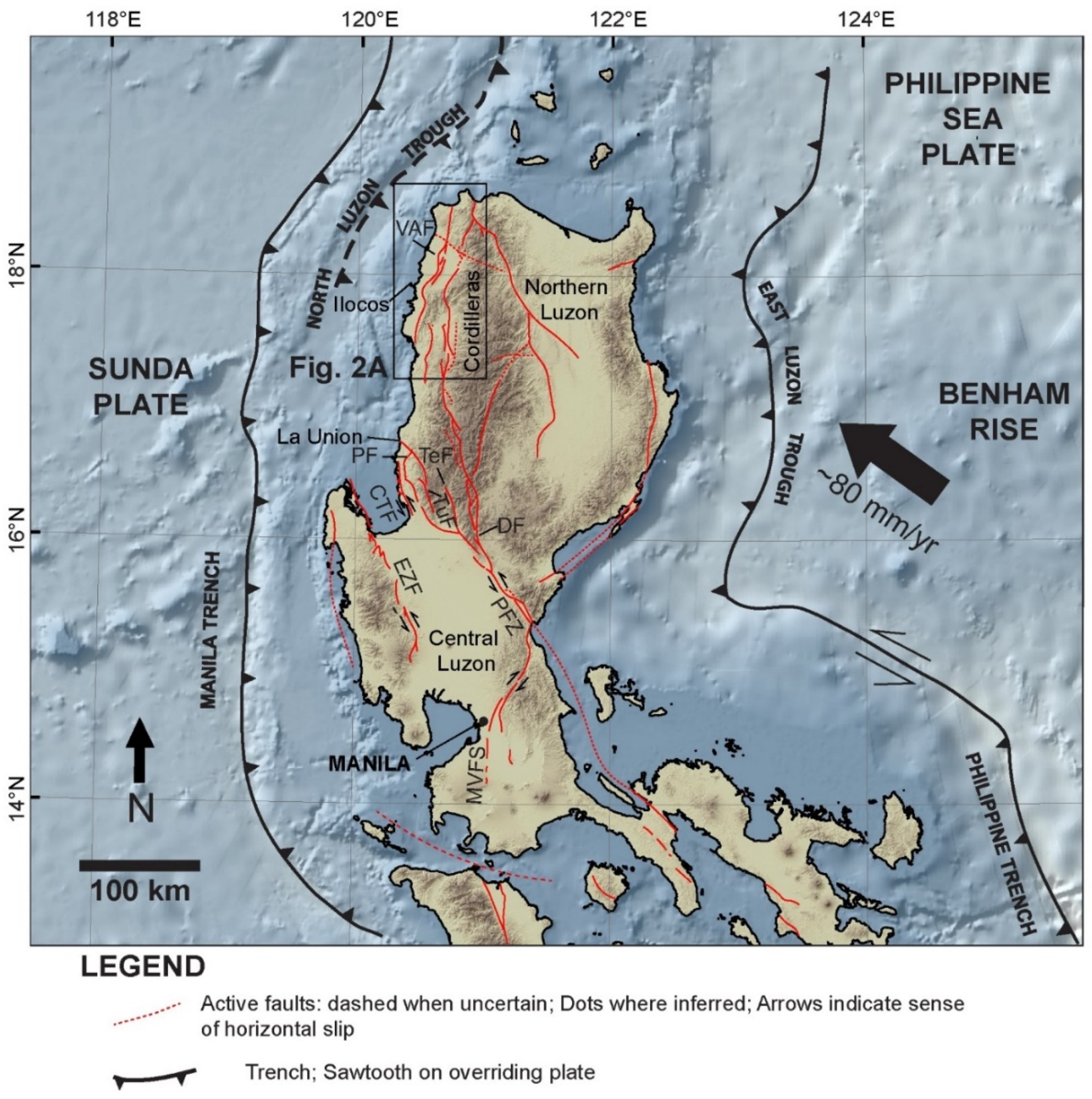
The major and minor active faults in northern Luzon and adjoining areas belong to a system of faults and subduction zones that accommodates part of the deformation due to the northwestward drift of the Philippine Sea Plate (PSP) towards the Sunda Plate (SP) (
Figure 1). The foremost of these faults is the Philippine Fault Zone (PFZ), with the Vigan-Aggao Fault being located in the westernmost part of this fault system.
How the Vigan-Aggao Fault and other major faults in the area within and in the vicinity of the PFZ accommodate crustal shortening through strike-slip and vertical slip is still uncertain, but may be clarified by a kinematic analysis of associated morphotectonic and structural features.
With the exception of a few segments of the PFZ and the Marikina Valley Fault System (or MVFS), most of the major active faults in the northern and central Luzon region have yet to be properly mapped (
Figure 1).
Numerous potentially hazardous minor active faults (e.g., in central Luzon) that are located within the blocks bounded by the major active faults are not yet known, let alone mapped in detail. The lack of understanding of faulting derived from comprehensive mapping and an accurate assessment of the kinematics of structures is a source of significant uncertainty in earthquake hazard and risk assessment for the region. The recent sense of motion of some major active faults in the region, for example, may have been inaccurately labeled because the methods used for determining recent kinematics are not appropriate (e.g., the Vigan-Aggao Fault and Coastal Thrust Fault (CTF) were misconstrued as thrust instead of strike-slip; the Bangui fault was mislabeled as strike-slip instead of normal; and the East Zambales Fault (EZF) was misconstrued as thrust instead of strike-slip). With inaccurate mapping and faulting mechanisms, the magnitude of resulting hazards and the severity of damage from earthquakes may have been greatly miscalculated. Due to our limited knowledge on these active faults, our understanding of deformation of the region resulting from plate motion is also limited. This study, in part, aims to address not only the issue on the kinematics of the Vigan-Aggao Fault, but also its continuity. In addition to its tectonic significance, a better understanding of the continuity and kinematics of the Vigan-Aggao Fault has implications for the estimation of seismic hazards it poses for nearby coastal towns of northern Luzon.
The neotectonic data generated would be useful in elucidating the deformation mechanisms of structures and the kinematic relationship of major and minor faults (e.g., MVFS, EZF, and PFZ) in two adjacent deformation environments (i.e., central and northern Luzon). This would also lead to an understanding of the plate kinematics and geometry of subducting plates and their boundaries, as well as the style, nature, and distribution in space and time of some of the deformation resulting from plate interactions in the Philippines, and their role in the overall mountain building processes.
2. Regional Geology and Tectonics
The PFZ accommodates (
Figure 1) much of the relative movement of the two plates between the trench systems and may decouple the northwestward movement of the PSP from the southeastward movement of the Sunda plate [
1,
2]. Another view is that the PFZ accommodates the boundary-parallel component of the overall plate convergence as a trench-linked strike-slip fault related to the Manila trench and/or the Philippine trench [
3,
4,
5]. To a certain degree, the known and predicted slips of the PFZ and most of its splays are consistent with this west-northwest to northwest motion of the PSP. The mountain range of the Cordilleras is cut by the PFZ and its branches. Among the more prominent faults in the area are the Digdig, Tebbo, Pugo, Tuba, and Coastal “Thrust” Fault [
6] (
Figure 1). The Cordilleras, which is composed of granodioritic bodies, shallow- to deep-sea sedimentary units, and volcanics, began uplifting during the Miocene. During the Pleistocene, the rate of its uplift is believed to have been 1.5 mm/yr [
7]. About 2 cm/yr of crustal shortening is co-seismically accommodated by the Philippine fault.
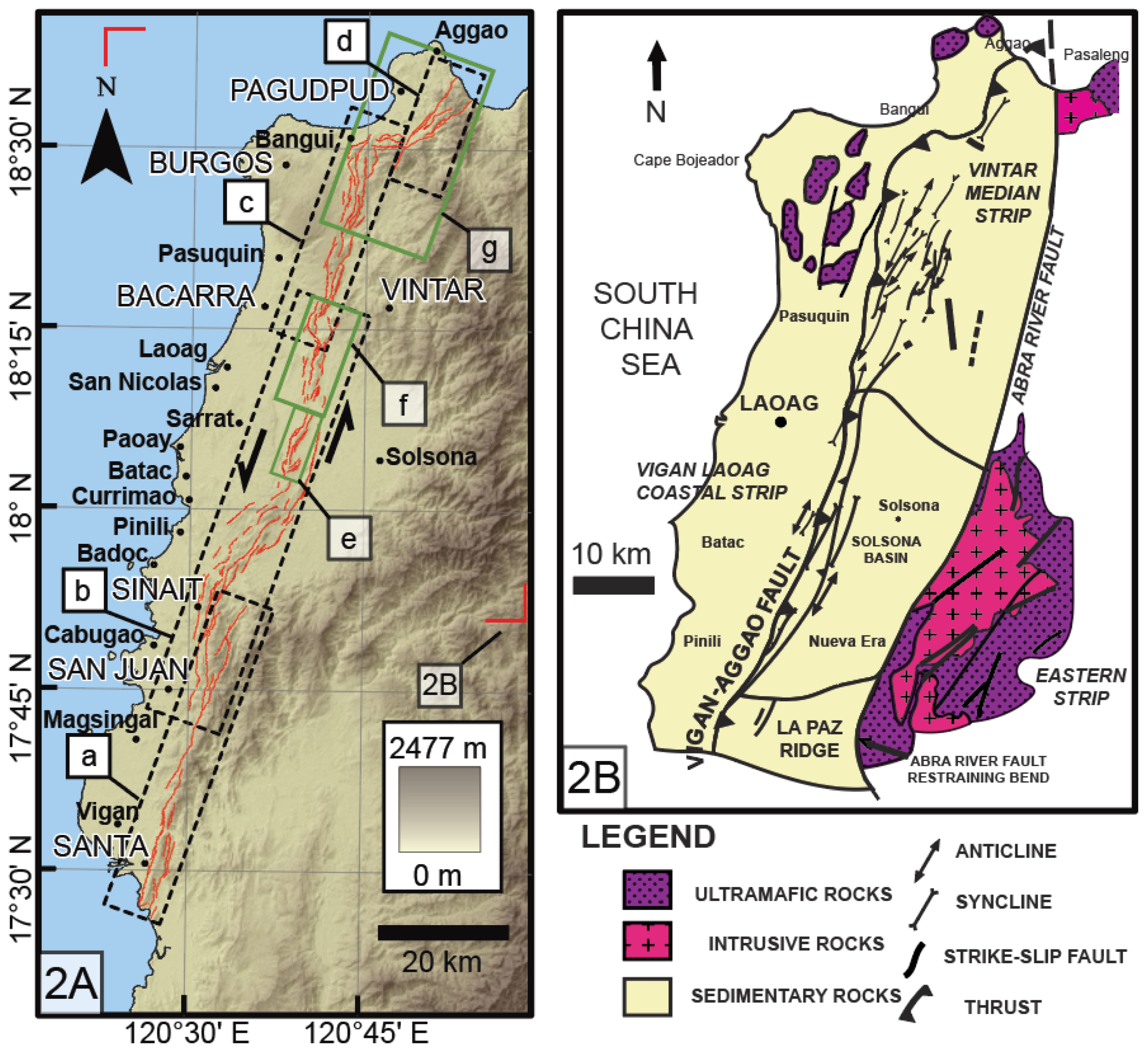
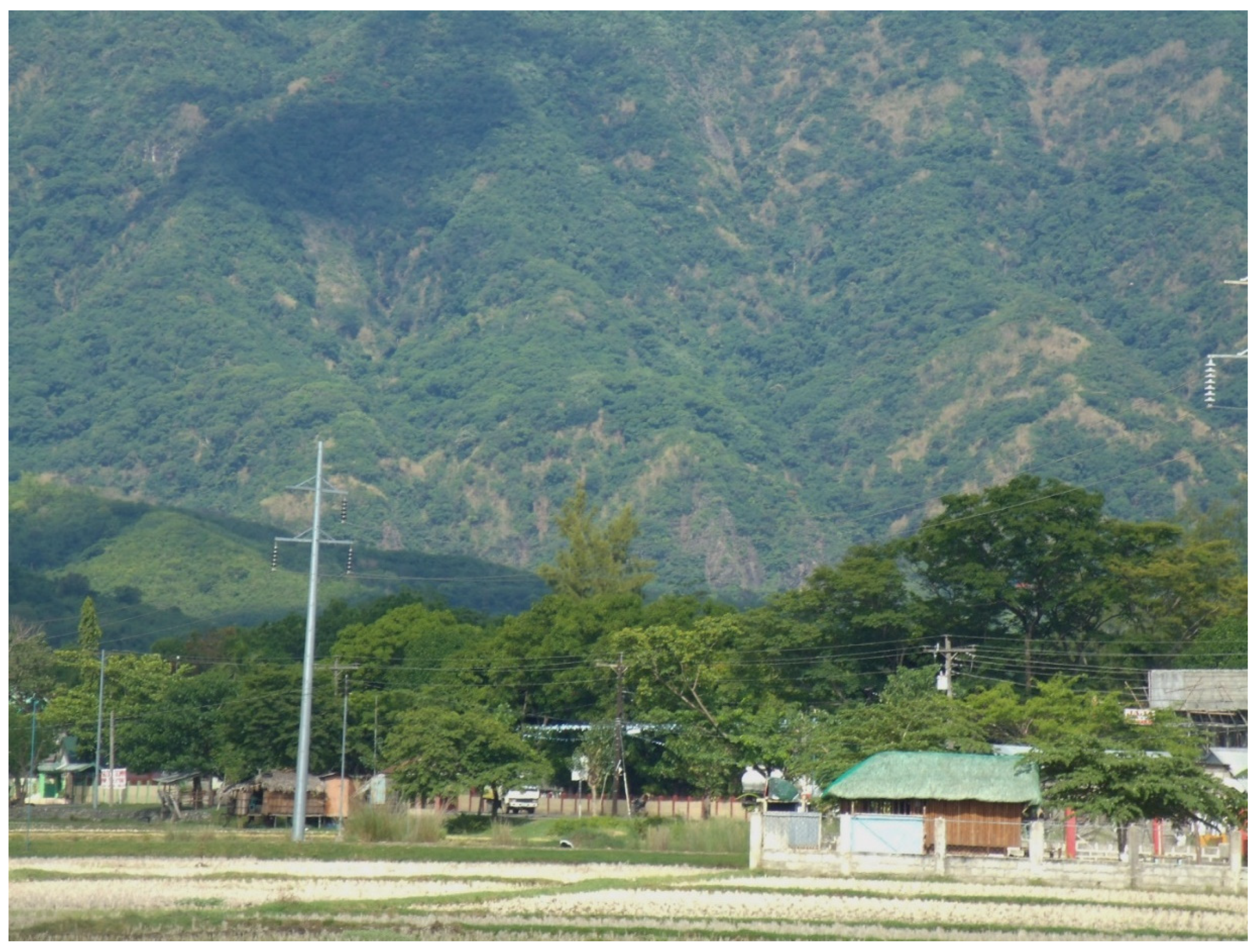
The Vigan-Aggao Fault (
Figure 2A) is the westernmost strand of the PFZ in northern Luzon. It represents the active deformation front along the western side of northern Luzon [
7]. The strike-slip activity of the PFZ has apparently propagated westward from the Middle Miocene to the present and the Vigan-Aggao Fault has represented the active deformation front in the region since it became active in the Pliocene [
8]. The folded area associated with the fault is 5 km wide [
8]. Along with the left-lateral strike-slip Abra River Fault to the east, it controls the formation of the Solsona Basin based on the elevation and observed deformation of sediments adjacent to the fault.
3. Methodology
Many landforms suggest youthfulness and are very useful in identifying the active traces or strands of fault zones. Some authors [
9,
10,
11,
12,
13] have related the freshness of appearance and type of geomorphic expression of faults to the age of faulting. Among the most distinctive characteristics of active strike-slip faults is an array of distinctive physiographic features [
14]. Many of the features can be explained by extension or contraction through simple shear [
15,
16] or through their location in releasing or constraining bends or steps of fault traces [
17,
18]. A variety of fault-formed structures, such as pressure ridges, sag ponds, shutter ridges, and systematically offset/deflected streams, have been documented by investigators, e.g., [
19,
20,
21,
22,
23,
24,
25,
26,
27,
28,
29,
30,
31]. Neotectonic strip maps such as those for the San Andreas Fault [
32,
33,
34,
35] and for other faults elsewhere typically show these characteristic landforms. Slemmons (1982) [
11] compiled a list of the main geomorphic features which are associated with active strike-slip, thrust, and normal faults, and showed how the sense of motion deduced from the offset of these features can vary along different types of fault.
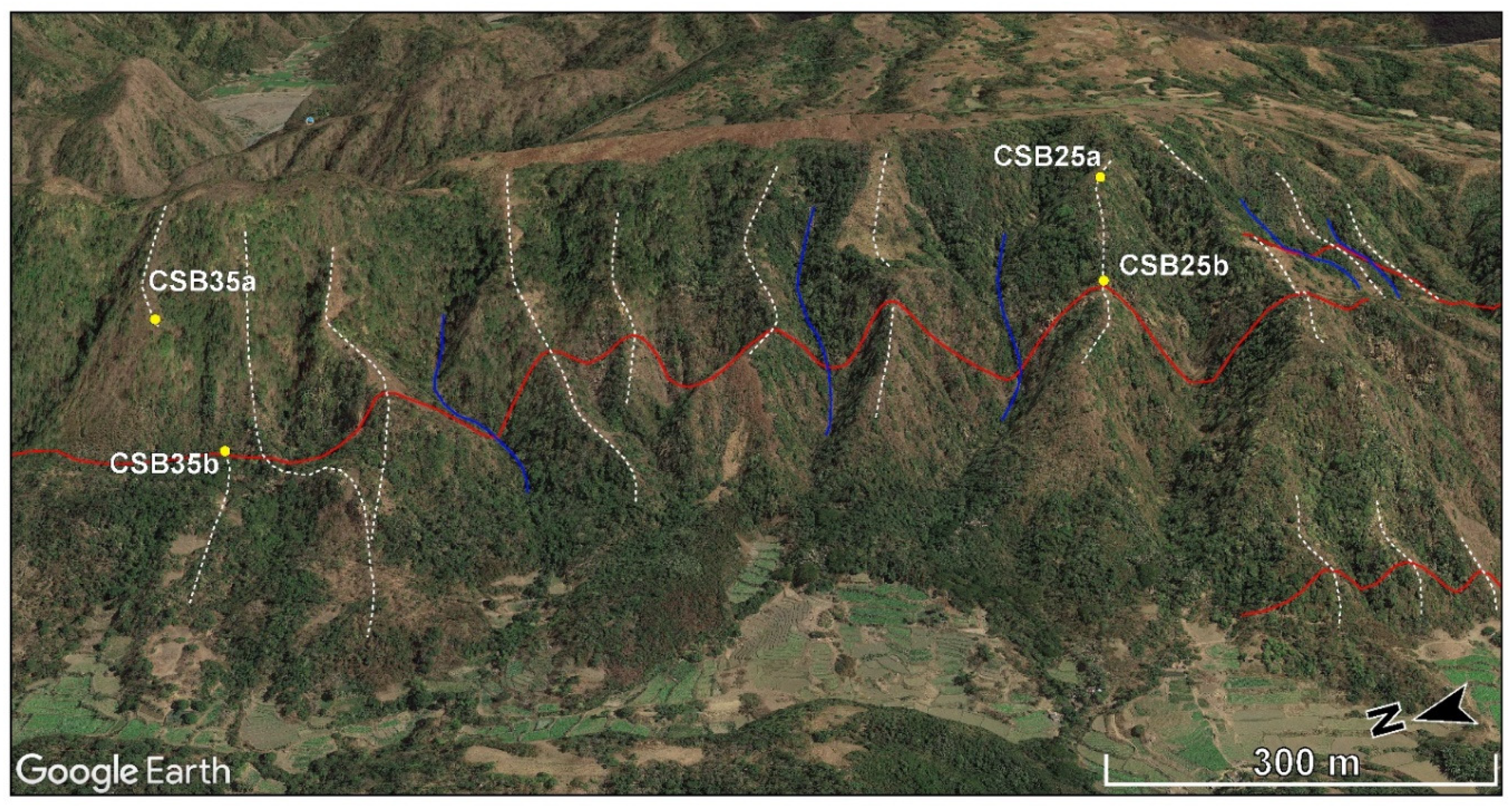
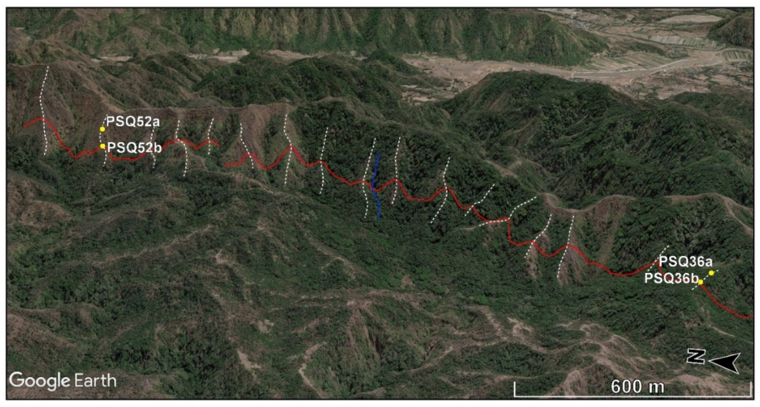
For the Vigan-Aggao Fault, the mapping of active trace and sense of motion of segments are inferred from offset values taken from each reference feature, primarily from offset spurs, which are more abundant along the whole stretch of the fault. Offset streams are as abundant, but piercing points on these provide far less reliable values for vertical separations than for horizontal offsets compared to offset spurs. We used satellite images from Google Earth for the rapid visualization, identification, and measurement of horizontal and vertical offsets from piercing points of offset reference features. The mosaic of images in Google Earth can be relied upon for horizontal offsets, but vertical separations were extracted both from these images and from ASTER (Advanced Spaceborne Thermal Emission and Reflection Radiometer) Global DEM (Digital Elevation Model) Version 2 (GDEM V2; 2011). ASTER has a more complete coverage for the study area compared to SRTM and, therefore, provides more homogeneous positional data. Google Earth and ASTER DEM are free and readily accessible. Since the results are comparable, only the results from Google Earth are presented herein.
The superimposition of digitized traces of active faults on Google Earth is becoming a standard practice for visualizing active faults, but the use of Google Earth in mapping active faults is still uncommon. This work marks the first instance of the extensive use of Google Earth as a tool in mapping and determining the kinematics of active faults. Google Earth superimposes satellite images and/or aerial photographs over DEMs. It uses DEM data from NASA’s SRTM mission for its 3D capability. Although the use of Google Earth in visualizing and extracting topographic data for various applications has been increasing since it was first introduced in 2005, issues regarding the positional accuracy have perhaps limited its use to mainly visualization and display. Assessments of Google Earth’s positional accuracy and applicability have provided variable results [
36,
37,
38,
39]. Surprisingly, a comparison of the accuracy of elevation data from Google Earth with those from other sources has shown that, in most places, only a limited number of sources (e.g., total station surveys, differential global positioning surveys (DGPS), or topographic maps from high-resolution aerial photography) can rival Google Earth’s accuracy, which is found to be more accurate than most aerial photography-based topographic maps and, occasionally, SRTM. This is made possible by updating Google Earth with better resolution images and by its use of other technologies and alternative data sources [
37]. In this study, resolution issues involved in vertical separation measurements using Google Earth and other sources of uncertainty in evaluating the sense(s) of motion are considered. Whether the uncertainty is large enough to render inferred sense(s) of motion unreliable will be a primary consideration in appreciation of the results for the Vigan-Aggao Fault area.
4. Previous Studies
Earlier studies are unclear about the recent kinematics of the Vigan-Aggao Fault, e.g., [
7,
8,
40]. In particular, detailed evidence on continuity, and the variation and controls of horizontal and vertical components of displacement, has yet to be presented [
7,
8,
40]. The Vigan-Aggao Fault has also been linked to the Coastal Thrust Fault (CTF) in La Union as its northern extension, partly on the basis of its similarity in terms of kinematics (i.e., having a thrust component) and partly on the basis of an interpretation of offshore seismic profiles south of Vigan [
41].
There remains uncertainty as to whether the Vigan-Aggao Fault has a dominantly thrust, e.g., [
40,
42] or strike-slip [
7,
8] faulting mechanism (
Figure 2B). The Vigan-Aggao Fault has previously been described as an NNE- to NS-trending, east-dipping thrust fault (40° to 55° E), with a length of 132 km from Vigan (Ilocos Sur) to Bacsil (Ilocos Norte), based on aerial photograph interpretation and observed structures [
40]. Additionally, the fault between Vigan and Aggao has been characterized in terms of the range front linearity, landform “disruption”, and changes in lithology, using Defense Mapping Agency (DMA) aerial photographs and synthetic aperture radar (SAR) images [
40]. In contrast, the Vigan-Aggao Fault has been described as a sinistral strike-slip fault with a thrust component, based on field structural observations and an analysis of fault plane slickenlines from outcrops, and is considered the westernmost strand of the PFZ in northern Luzon [
7,
8]. Ringenbach (1993) [
7] posited a northward increase in the thrust component of the strike-slip fault, which is consistent with Pinet and Stephan’s (1990) [
8] observations of thrust features. The fault also forms the western boundary of the Solsona basin, which is bounded by the Abra River Fault to the east. Pinet and Stephan (1990) [
8] and Ringenbach (1993) [
7] inferred that Plio-Quaternary convergent wrench faulting that formed a positive flower structure (of the Vigan-Aggao Fault) with a narrow, elongated ridge expression along the fault’s trace, was instrumental in the basin’s formation. The “flower structure” supposedly consists of parallel upthrusts with opposite dips and
en echelon folding. However, no details similar to the aforementioned descriptions were provided for the segments north and south of the fault segment in the Laoag area.
A detailed analysis of displacement data from the measurement of offset morphotectonic features can allow a comprehensive and systematic clarification of the kinematics of the Vigan-Aggao Fault. Aside from determining the fault’s kinematics, our analysis also aims to address the question of the Vigan-Aggao Fault’s segmentation and continuity to the south of Vigan. The Vigan-Aggao Fault is thought to be linked to the Coastal Thrust Fault in La Union, partly on the basis of the supposed similarity in the sense of slip (i.e., both are believed to be thrust faults) [
2], and partly on the continuity inferred from offshore seismic profiles south of Vigan [
43]. Such previous studies, however, are uncertain about the fault’s northern terminus.
6. Discussion and Interpretation
The Vigan-Aggao Fault is clearly a strike-slip fault rather than a thrust fault or normal fault, as suggested by earlier studies [
40,
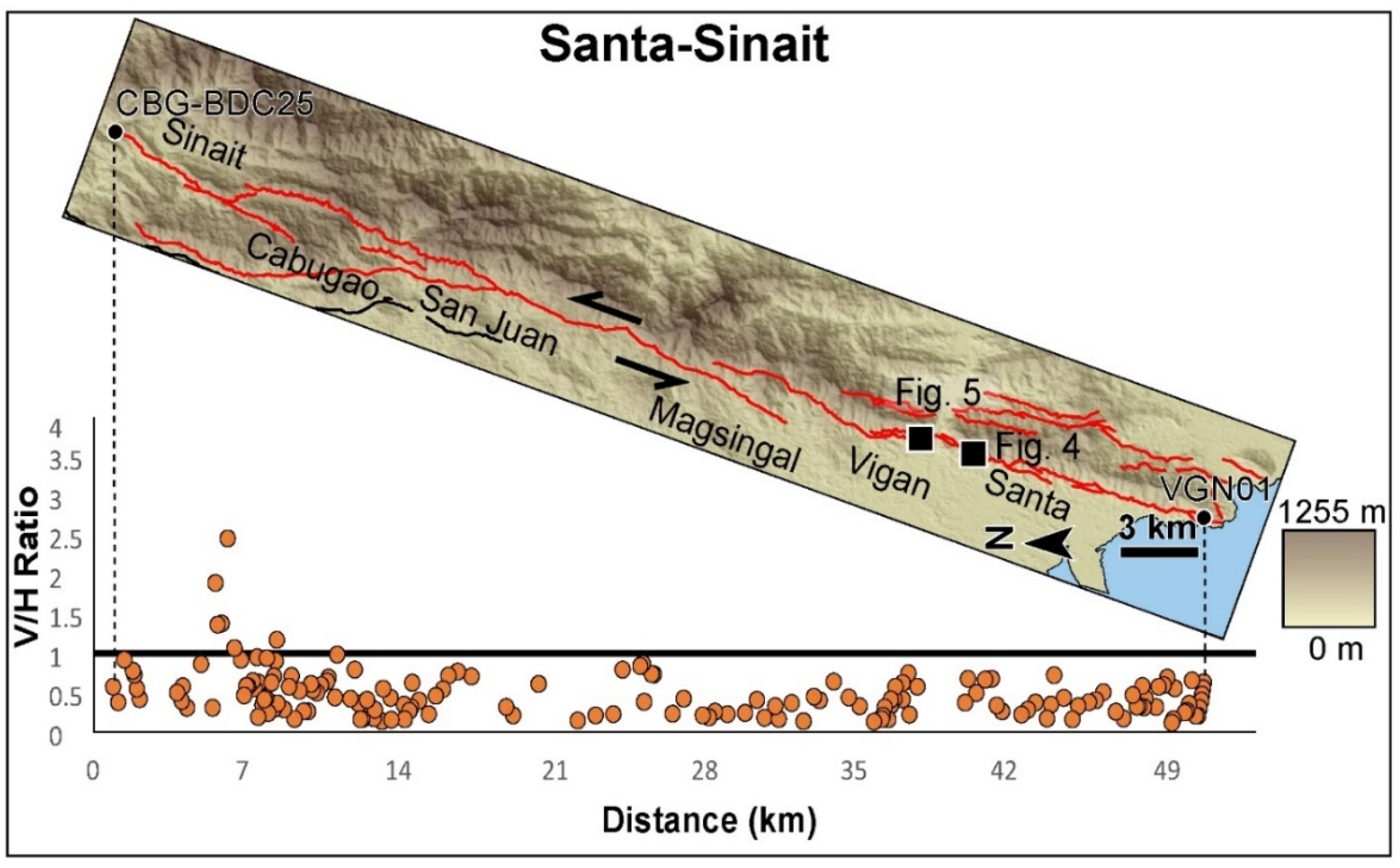
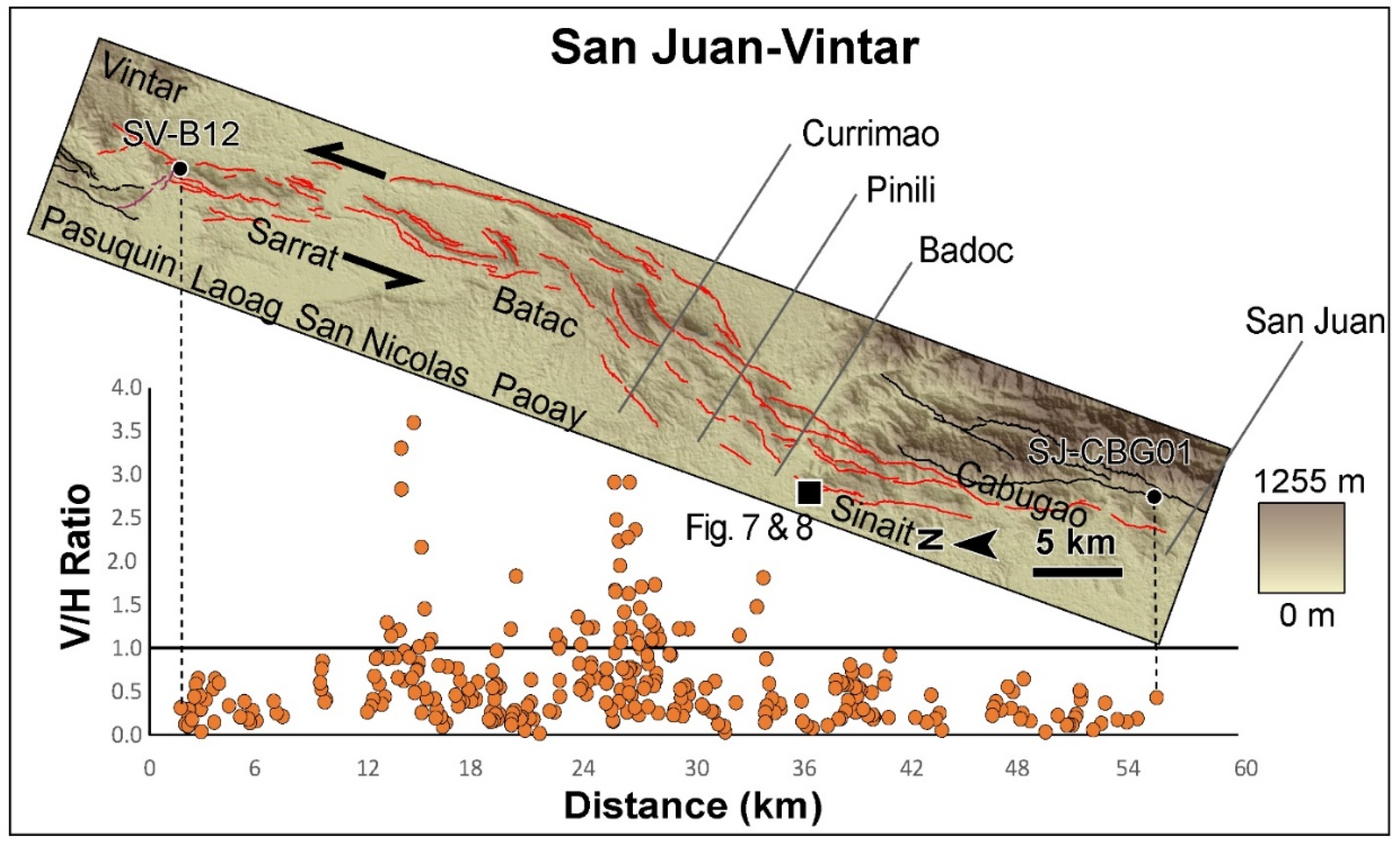
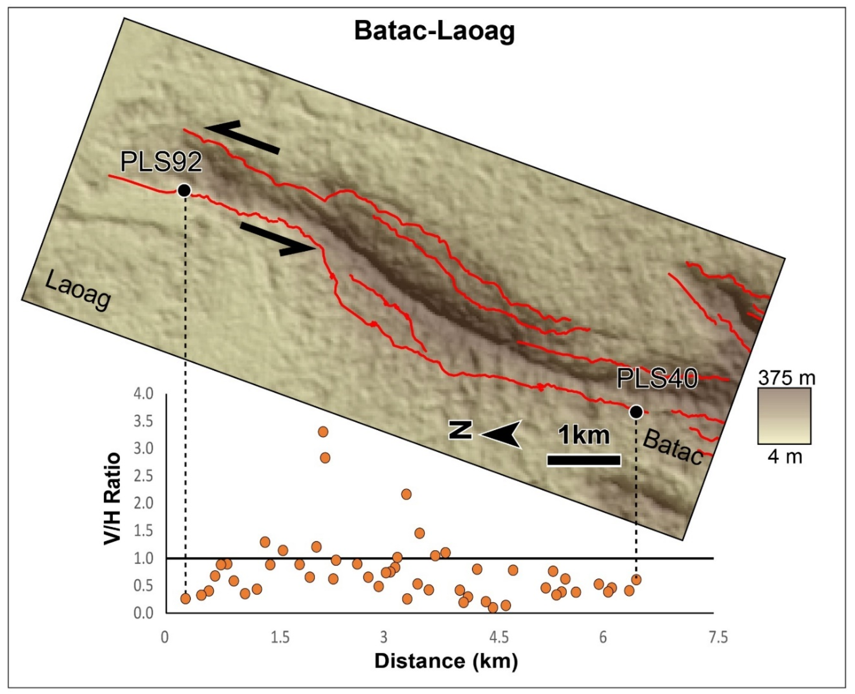
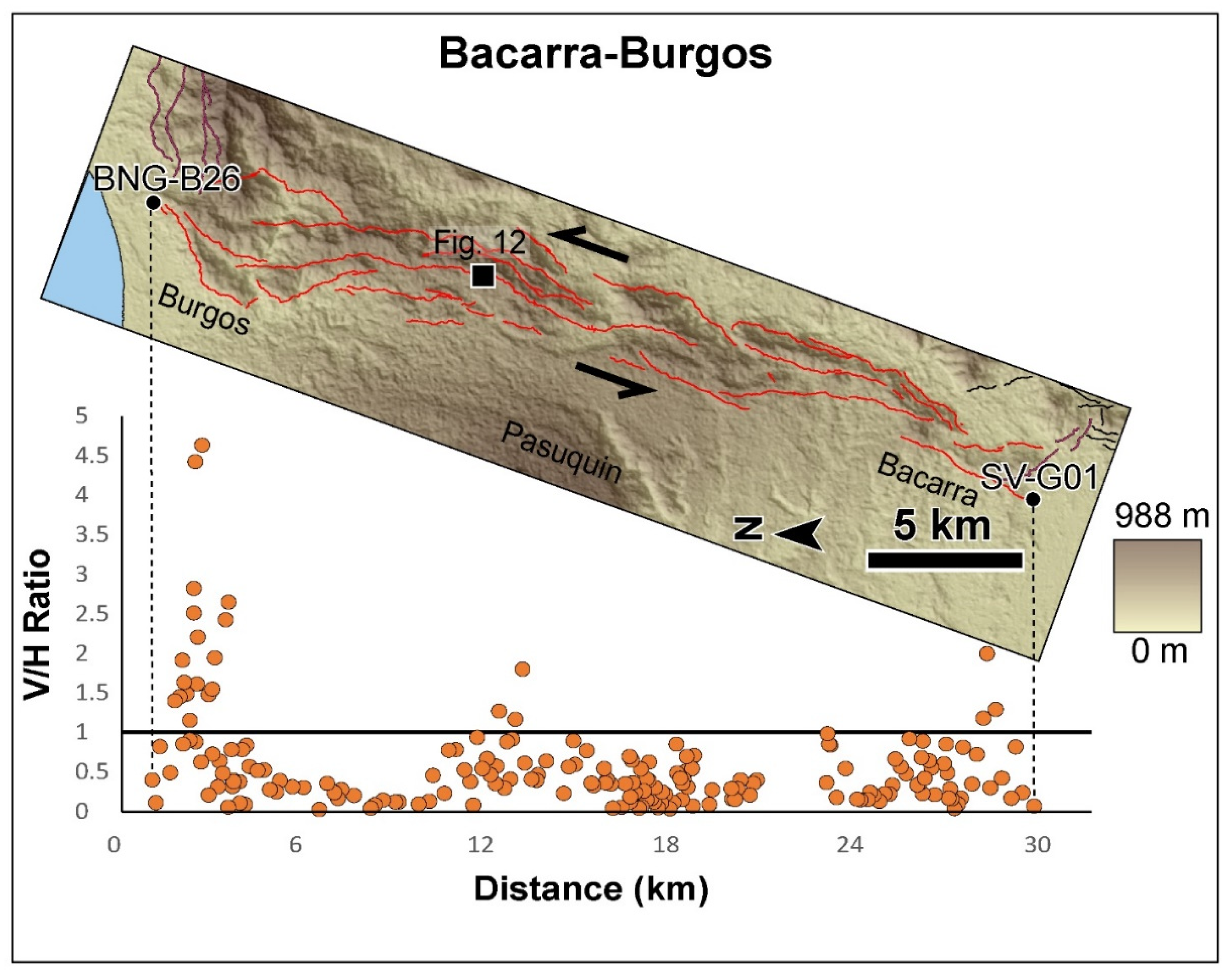
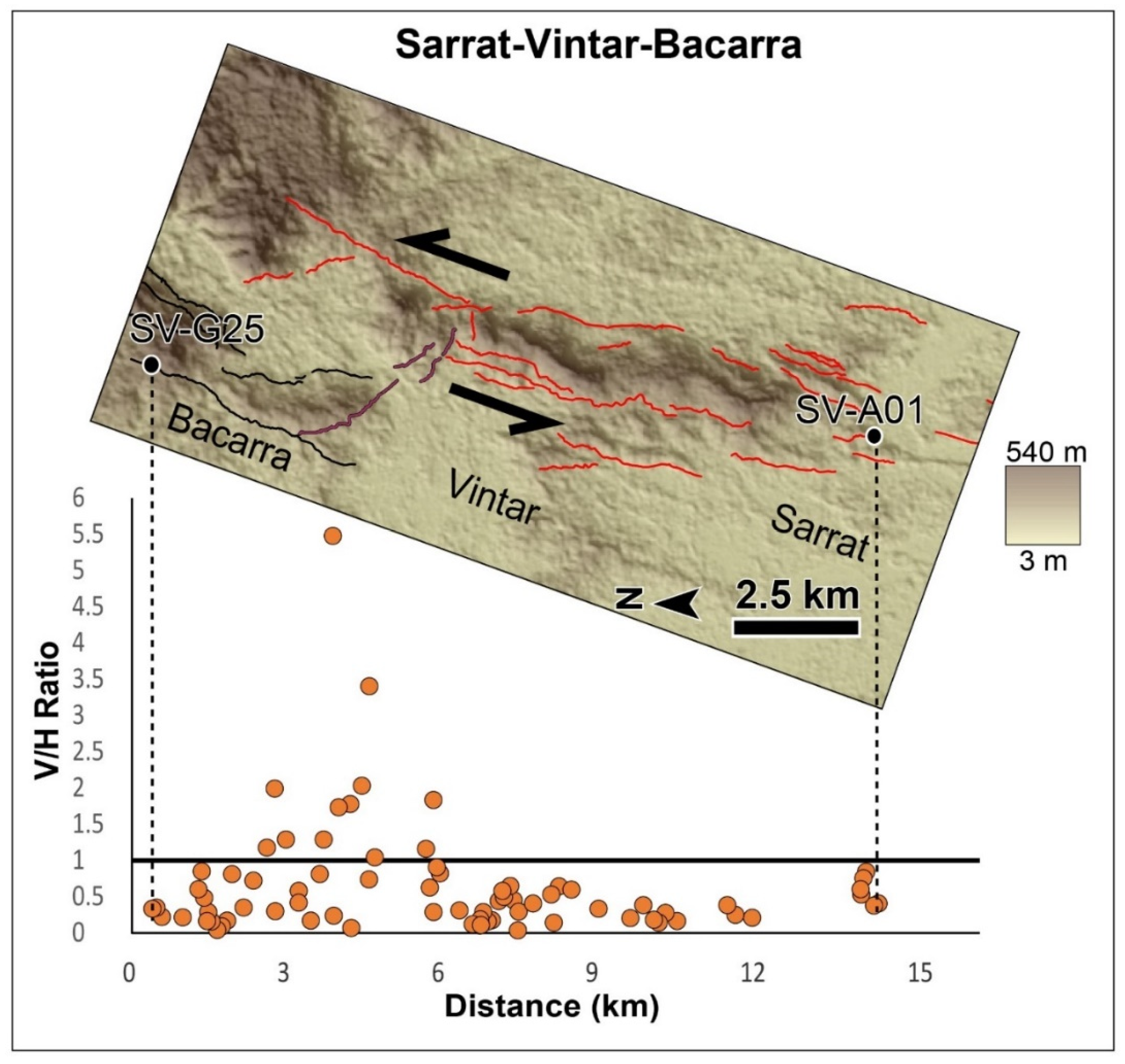
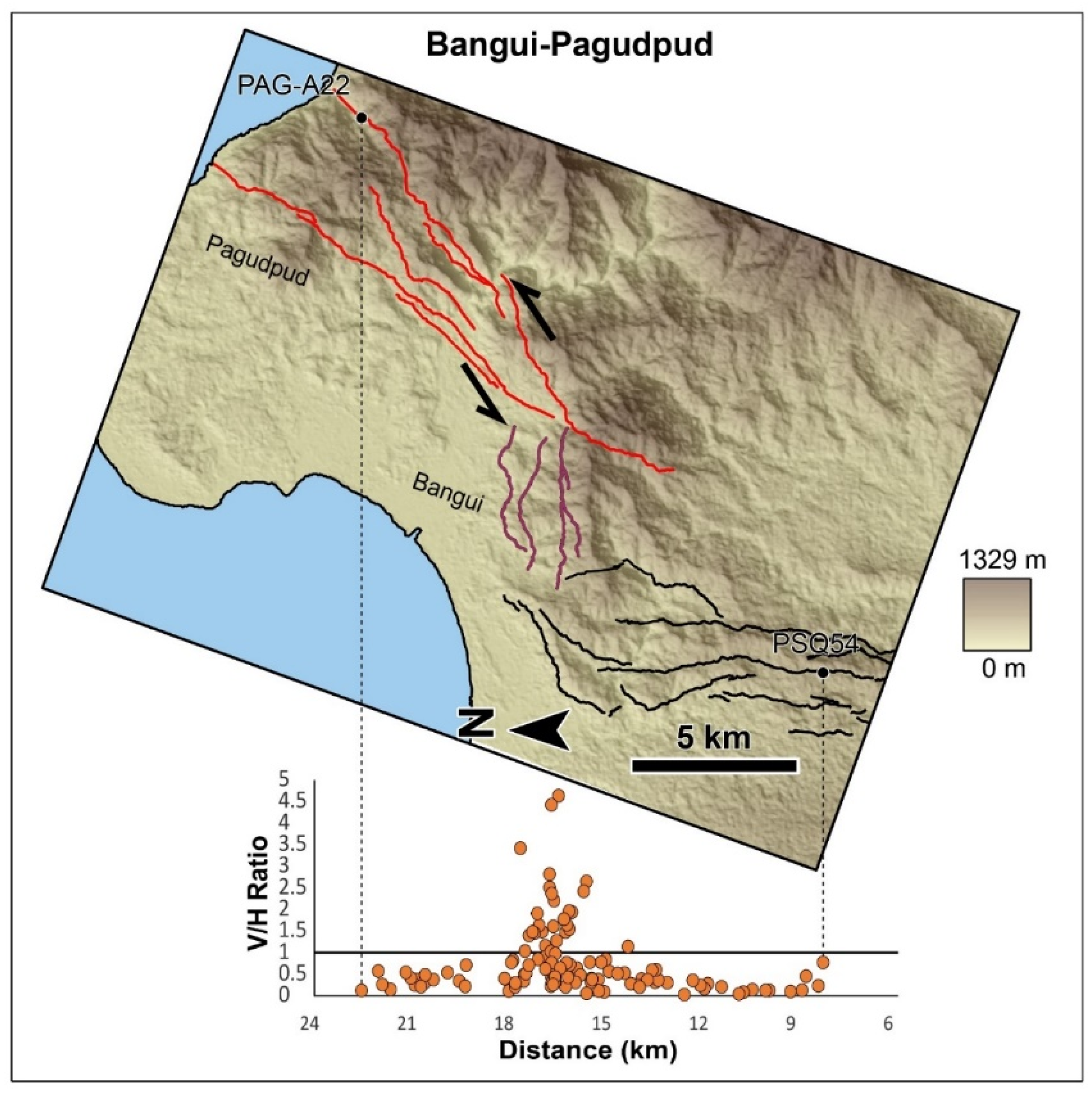
42]. This is based on the associated morphotectonic features that characterize strike-slip faults and on the more dominant horizontal component of slip. Along most of the stretch of the Vigan-Aggao Fault’s segments, the horizontal component of slip is much larger, as indicated by the V/H values, which were mostly below 1. The majority of the points below the V/H = 1 line are lower than 0.5. Locally, a large vertical component of displacement is associated with thrust or normal faults. The locations of these zones are strongly correlated with the locations of bends and jogs. Within these regions, both dextral and sinistral sense of the horizontal component of displacement coexist. This is not the case, however, outside of these zones of bends and jogs. The segments of the Vigan-Aggao Fault outside of the jogs and bends host V/H values below 1.
The reliability of the V/H ratio as an indicator of the sense of faulting depends on how well the vertical separation (V) measurements represent the dip-slip component of displacement. The use of SRTM elevation values from Google Earth is a source of uncertainty. The use of Google Earth poses positional errors, which are greater for elevation. The degree of underestimation of elevation due to the use of SRTM values becomes greater for higher elevation areas. Moreover, the higher the piercing points and the higher the elevation difference between two piercing points, the higher the error will be. Several studies, however, have demonstrated the reliability of elevation measurements from Google Earth relative to other available tools [
36,
37,
38,
39]. Additionally, the vertical separation value may underestimate the dip-slip component of displacement, wherein the underestimation is greater for more gentle dips. The dip of the Vigan-Aggao Fault is said to be variable along its trace [
46]. Because fault dips are variable, using an assumed uniform dip to estimate dip-slip introduces another source of error. The amount of underestimation from using vertical separation may not be as critical for parts of the fault with steep dips. Lastly, an underestimation/overestimation of vertical separation may also come from the varying amounts of erosion at the upthrown side and deposition of slope material on the downthrown side.
While a great majority of V/H values outside of the bends and jogs fall well below 1, borderline V/H values raise a question regarding the degree to which the dip-slip components of displacement were underestimated, considering the sources of uncertainty involved in estimating vertical displacements. However, the sense of left-lateral strike-slip are consistently sinistral outside of the jogs and bends. This reinforces the assessment that the Vigan-Aggao Fault is primarily an oblique sinistral strike-slip fault, rather than a thrust fault. This implies that the contributions of the sources of errors to the vertical separation estimates are not significant, at least in the case of the Vigan-Aggao Fault.
Oblique sinistral strike-slip faulting along the Vigan-Aggao Fault is kinematically congruent with the known sense of motion of the PFZ and its strands in northern Luzon (e.g., Tuba, Tebbo, Mirador, Abra River, Pugo, San Manuel, San Jose, Digdig, and Hapap). This is also consistent with the sense of motion of the Coastal “Thrust” Fault (CTF). The Coastal Thrust Fault (CTF) forms the northeastern boundary of the central Luzon basin (
Figure 1). Only regional maps of active faults in coastal La Union are available, and these indicate a thrust mechanism of faulting for the CTF. Our own analysis, however, clearly indicates left-lateral strike-slip with a more minor vertical component of slip. This suggests that the Vigan-Aggao Fault and the CTF are, more likely, part of the PFZ in northern Luzon—a system of faults that accommodates shortening in the region, mainly through strike-slip. Left-lateral strike-slip faulting along the PFZ is consistent with this westward en masse drift of the PSP. The kinematics of the major faults in northern Luzon and northern Luzon (e.g., Bornay, Asin, Bangui Fault, and East Zamabales Fault), which were previously indicated as either thrust or normal [
6,
8,
40,
42,
43], should be verified. This should also put into proper perspective how deformation is accommodated and distributed along the major structures and geological features.
Studies on the kinematics of active faults in the northern Luzon region should help clarify deformation in the region. Such studies, however, should be detailed enough to show relative contributions and along-length variations in vertical and horizontal displacements. A detailed morphotectonic analysis for the kinematics of active faults in northern Luzon needs to be conducted to help clarify this. Maleterre (1989) [
43] highlighted the contribution of significant vertical displacements along the PFZ to the uplift of the Central Cordillera due to oblique convergence between the SP and the PSP. Maleterre (1989) [
43] cited the significant thrust component along the Vigan-Aggao Fault. Until this study, it is clear that details on the contribution of the vertical component of motion of the Vigan-Aggao Fault have remained largely unknown. The Abra River Fault has also been characterized as having pure strike-slip motion [
6]. However, morphotectonic observations and investigations on the displacement variations along the Digdig Fault, before and after the 1990 Luzon earthquake, centered along the fault [
47,
48], strongly suggest that this may not be the case.
Through a detailed morphotectonic analysis comes the opportunity to assess the sense of slip of other active faults more accurately. The MVFS (
Figure 1), for one, has been found to have a dominantly dextral strike-slip motion from geomorphic evidence gathered along the entire length and its segments [
6,
49]. Considering its right-lateral strike-slip motion, lateral extrusion of the block bounded by the PFZ and MVFS [
6,
49] and block rotation (both regional and local) as a complementary mechanism have been used to explain the kinematics of the MVFS [
6,
49].
No detailed basis and clear evidence for the kinematics of other active faults outside of the PFZ have been made available. A careful analysis of the displacement of morphotectonic features shows a dominant sense of slip different from mechanisms earlier indicated for the recent movement of some of these faults (e.g., East Zambales Fault and Bangui Fault). With a more accurate determination of the kinematics of active structures, it is easier to see how these faults fit in the overall scheme of deformation in northern Luzon as a result of the northwestward motion of the PSP.
We also estimated possible associated earthquake magnitudes for the Vigan-Aggao Fault using an equation relating the magnitude to the surface rupture length [
50]. However, to assess the seismic potential of the Vigan-Aggao Fault, we must make assumptions as to whether the entire trace or only individual segments could rupture co-seismically. Due to the absence of independent paleoseismic data along this fault to support either scenario, we explored both scenarios to arrive at a seismic hazard assessment of the fault.
Assuming co-seismic rupture of individual segments, the Santa-Sinait (49 km), San Juan-Vintar (65 km), Bacarra-Burgos (31 km), and Pagudpud (17 km) segments yield magnitude estimates of MW 6.9−7.3, MW 7.0−7.4, MW 6.7−7.1, and MW 6.3−6.7, respectively. On the other hand, assuming a maximum surface rupture length of 140 km for the entire length of the Vigan-Aggao Fault yields an estimate ranging from MW 7.4 to 7.8.
7. Summary and Conclusions
Our morphotectonic mapping of the Vigan-Aggao Fault has revealed a complex pattern of active fault traces and segmentation. It has also provided evidence, primarily from offset spur and streams, of the active fault’s sense of motion. The Vigan-Aggao Fault in Ilocos Sur and Ilocos Norte is an oblique sinistral-strike-slip fault. The sinistral nature of the fault is supported by measurements of the horizontal and vertical displacements indicating that lateral displacements are dominant along the length of the fault. Extremely high V/H ratios, characteristic of thrust and normal faults, are confined to regions in the vicinity of jogs and bends. Despite the uncertainties involved in the estimation of the vertical component of displacement using vertical separation as a proxy, the majority of the V/H values outside of the bend and jog regions are below 1 while a large part of these are below 0.5. The consistency in the sense of horizontal displacement (sinistral) outside of the zones of bends and jogs indicates that the vertical separation measurements are reliable proxies for the dip-slip component of displacement in the case of the Vigan-Aggao Fault.
The assessment of the Vigan-Aggao Fault’s kinematics is consistent with the data of Pinet and Stephan (1990) [
8]. However, a more detailed delineation of the active fault’s traces and a determination of its segmentation and sense of motion are provided by this study through the visualization and extraction of horizontal and vertical displacement data from numerous offset morphotectonic features. This study goes farther, and into more detail, by explaining the along-strike variation of displacement by recognizing local zones of transpression and transtension that are associated with bends and step-over gaps. Applying the method outlined herein should help verify the kinematics of other mapped and unmapped active faults, not only in the Philippines, but also in various tectonic settings.
The continuity of the Vigan-Aggao Fault with the Coastal Thrust Fault, however, must be verified. The similarity in kinematics of the CTF and the Vigan-Aggao Fault indicates that these strike-slip faults are probably part of one strike-slip system (West Ilocos Fault System). Its proximity and a sense of motion that is similar to the other splays of the PFZ form a strong argument for its inclusion within the PFZ.
Based on the length of the entire fault and its segments, the sinistral strike-slip Vigan-Aggao Fault is capable of generating earthquakes ranging in magnitude from MW 6.3 to MW 7.8. An incorrect assessment of the sense of displacement of the major faults in northern and central Luzon will result not only in the overestimation or underestimation of hazards, but also in a misleading assessment of the deformation mechanism involved and of the contributions of the major structures in accommodating deformation in the region. The contribution of thrust faulting to the overall deformation budget may have previously been overestimated. A large part of shortening through faulting across central and northern Luzon is accommodated by strike-slip faulting, mainly along the PFZ. The Vigan-Aggao Fault participates in the shortening by strike-slip faulting rather than thrust faulting. The rest of the deformation due to the westward drift of the Philippine Sea Plate is accommodated by thrust faulting elsewhere (if there is any, or by the thrust component of oblique strike-slip faults), by subduction, and by regional uplift.
