Article

Geoheritage and Geotourism in Regions with Extinct Volcanism in Germany; Case Study Southwest Germany with UNESCO Global Geopark Swabian Alb

by
Heidi Elisabeth Megerle
University of Applied Forest Sciences Rottenburg, Schadenweilerhof, D-72108 Rottenburg am Neckar Baden- Wuerttemberg, Germany
Geosciences 2020, 10(11), 445; https://doi.org/10.3390/geosciences10110445
Submission received: 8 October 2020 / Revised: 30 October 2020 / Accepted: 4 November 2020 / Published: 8 November 2020
(This article belongs to the Special Issue Geomorphology, Geoheritage, Geoparks and Geotourism in Volcanic Areas)

Abstract

:
Geotourism has become more popular in recent decades. Volcanism is an essential part of geoheritage and attracts a high number of visitors. In contrast to active volcanism, Tertiary volcanism is often not identified as such by a lay audience and is understandably perceived as less spectacular. The challenge is therefore to protect the volcanic heritage, to communicate its values, and to enhance it with the help of adequate geotourism offers. Germany does not have active volcanism, but a very high quality volcanic geological heritage, especially from the Tertiary period. Fortunately, this heritage is being increasingly valued and presented in an attractive way for a lay audience. The two Geoparks in the Eifel (Rhineland-Palatinate) are pioneers in this field. The UNESCO Global Geopark Swabian Alb actually offers a well camouflaged potential. The Swabian volcano, with an area of 1600 km2, is one of the most important tuff vent areas on earth, but hardly known outside of expert groups. A comprehensive strategy for the geotouristic valorization of the Tertiary volcanic phenomena does not yet exist in the Geopark Swabian Alb.

1. Introduction

Tourism is rated as the “leading economy of the twentieth century” because of its high rates of growth and regional added value [1]. Geotourism, long considered a form of niche tourism, has become a popular form of theme tourism. Since the mid-1990s, not only geotourism offers, but also the scientific discussion of the definitional delimitation, as well as management, use, and enhancement of geoheritage have developed very dynamically (see [2,3,4,5,6,7,8,9]).
Volcanism has always fascinated and at the same time frightened people, and therefore attracted not only scientists, but also tourists. Travel to volcanic regions has become an increasingly popular branch of geotourism. Active volcanoes offer “nature’s most exciting and deadly shows” and a special thrill due to their unpredictability [10]. In regions with active volcanism, the volcanoes are among the “primary drawcards for visitors”, while in regions with dormant or extinct volcanism, they probably only play a secondary role. There, they need to be linked with other attractions in order to increase visitor numbers and length of stay [11]. However, dormant volcanism and landforms of extinct volcanism are also a defining component of the regional geoheritage and as such worthy of protection and important components of geotourism offers [12]. Although the dangers and risks of active volcanic areas do not exist here, on the other hand, landforms of extinct volcanism pose particular challenges to the development of attractive geotourism offers and geoenvironmental education (see [13,14,15]). With successful implementation, however, geotourism can provide a high attraction potential, contribute considerably to the understanding of the geological history of the respective region and arouse enthusiasm for the geoheritage. The economic effects of volcano tourism can also play an important role [16].
Germany is rarely mentioned as a destination for volcanic tourism, presumably because it has no active volcanism. However, there are numerous areas, shaped by volcanism in earlier geological epochs. This geological heritage is valorized intensively in some regions (e.g., Vulkaneifel, see Section 3.1), while in other regions (e.g., Geopark Swabian Alb) there is still some catching up to do. The present article focuses on Tertiary volcanism in Germany with a special case study of the UNESCO Global Geopark Swabian Alb located in southwest Germany. The later integrates with the so-called Swabian volcano (Schwäbischer Vulkan) a geological heritage of great importance. However, these volcanic landforms are difficult for laypeople to identify without further information. A special challenge therefore lies in adequate communication approaches in order to arouse fascination for these geological features.
The present article is based on a survey of literature as well as the homepages and information material of the integrated geoparks and other geotouristic sites, my own surveys in the area, expert interviews, and many years of experience as a scientist, landscape guide, and deputy chairwoman of the advisory board of the UNESCO Geopark Swabian Alb.

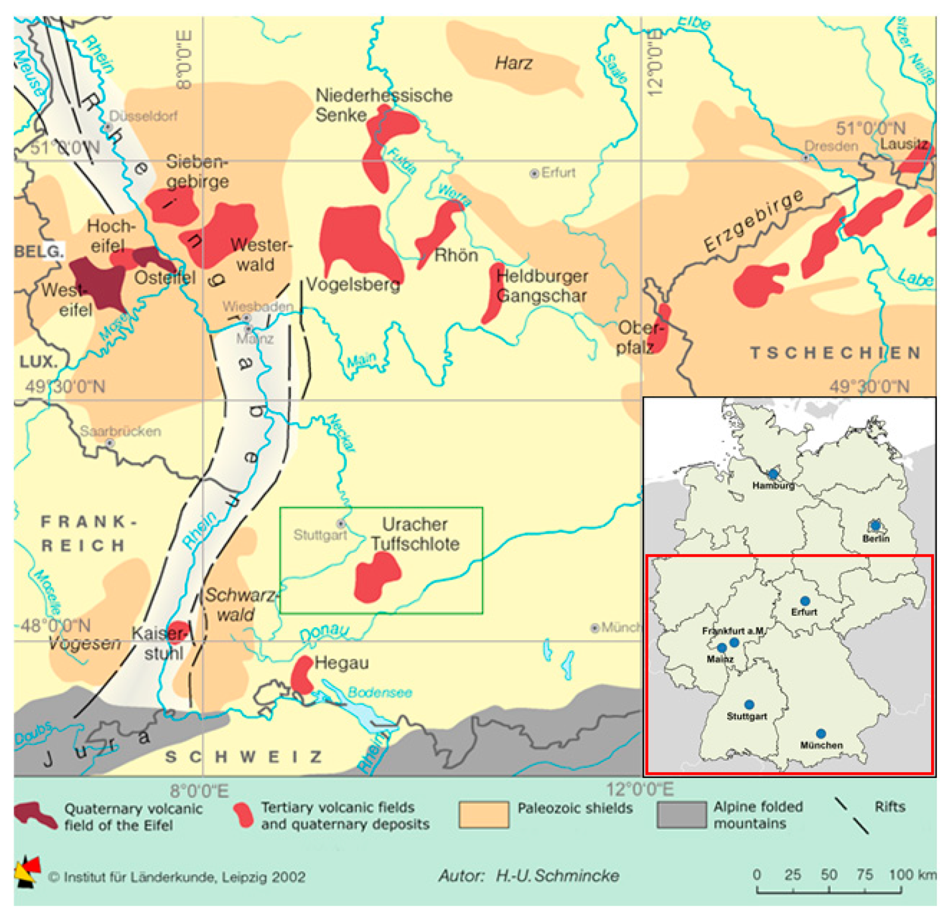
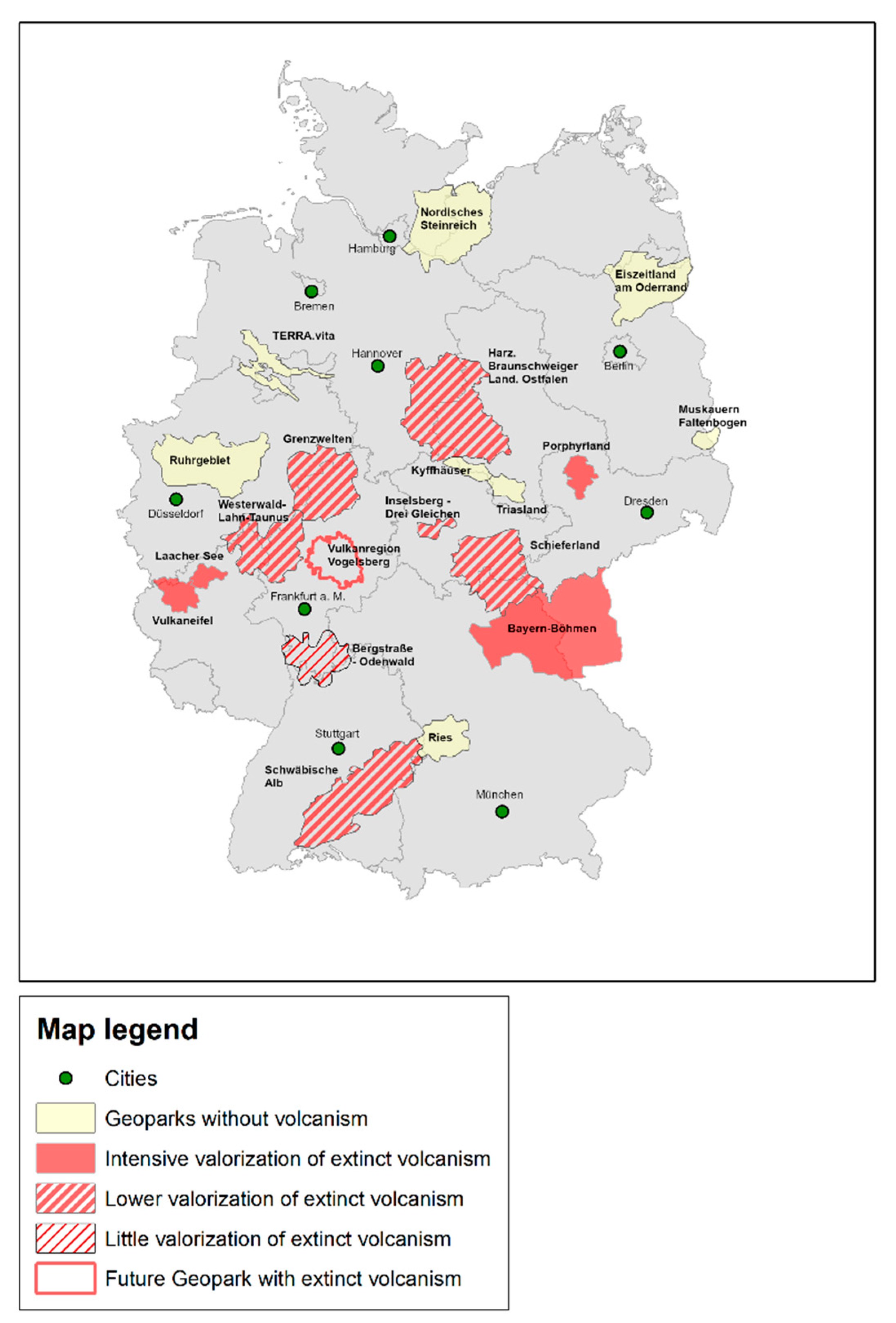
2. Volcanic Geoheritage in Germany

The Federal Republic of Germany currently has no active volcanism. The most recent documented volcanic eruption was around 11,000 years ago (Ulmen Maar in the Eifel, Rhineland-Palatinate). After-effects of these volcanic activities such as mofettes can still be found in the Eifel today. Since there is obviously still a magma chamber, further outbreaks cannot be completely ruled out [17,18].
As shown in Figure 1, extensive Tertiary volcanism areas are located in the central part of Germany in a zone running from west to east, integrating the Eifel (Rhineland-Palatinate), Siebengebirge and Westerwald in North Rhine-Westphalia, the Vogelsberg, Rhön and the Hessian Depression in Hesse as well as Oberpfalz (Bavaria) and Erzgebirge and the Egergraben in Saxony. Additionally, Tertiary volcanism is found in southwest Germany [17]. These areas are part of the European Cenozoic volcanic province, which stretches from the French Massif Central to Lower Silesia and is part of intraplate volcanism [19].
In the Eifel region, the eruption of the Laacher See volcano about 13,000 years ago produced six times more volcanic loose material than the eruption of Mount St. Helens in 1980. The tuff deposits, which reached heights of up to 20 m in the immediate vicinity of the eruption site, can be traced as far south as Turin (Italy) and as far as the Swedish island of Bornholm. In total, volcanic material was ejected or maars were formed at four hundred locations in the Eifel [17]. In this respect, volcanic landforms in the Eifel are still present in large numbers and are easy to recognize (for details see [20] and Section 3.1).
Both the volcanic landforms of the Siebengebirge and the Westerwald are related to the expansion movements in connection with the collapse of the Tertiary rift systems [17]. With an extension of 1.000 km2 the Westerwald hosts the second largest site of Cenozoic volcanic rocks in Germany [19].
In the Miocene, the Vogelsberg (Hesse) with 2100 km2, the largest contiguous volcanic area in Central Europe, was formed. Contrary to earlier interpretations, it is not a large stratovolcano, but the Vogelsberg consists of many basaltic and trachytic cover layers and is the result of a complex interplay of uplift and erosion [17].
The cross-border volcanic area Saxony-Czech Republic has volcanic material with an age of 65 million years up to the Quaternary [17]. Of particular interest to geotourists are basalt columns, such as those at Scheibenberg near Annaberg (Erzgebirge, Saxony).
Smaller volcanic areas are located in the Hessian depression, the Rhön and the Odenwald. The Messel fossil site near Darmstadt is world-famous. This site developed in a maar formed in the Eocene, represents an important archive of the landscape history of southern Germany, and has been a UNESCO World Heritage Site since 1995 [21]. Important fossil sites also developed in the sediments of other maar lakes, like Randecker Maar and Böttinger Marmor (Swabian Alb) and Öhningen and Höwenegg (Hegau) [22]. Due to the long duration of the Tertiary, the mostly excellently preserved fossils and the integration of groups of organisms (e.g., insects and arthropods), which are otherwise less frequently found, the research possibilities to understand the development history of flora and fauna are excellent. The volcanic landforms in southern Germany are described in more detail in Section 4.
Palaeozoic volcanic landforms can be found in the Geoparks Harz, Braunschweiger Land, Ostfalen and Schieferland. Volcanic landforms of the Rotliegend Period in the Geoparks Inselsberg—Drei Gleichen and Porphyrland (see Table 1).
Since the present article focuses on the geotouristic valorization of Tertiary volcanism, the geological background of extinct volcanism in Germany has only been sketched very briefly, especially the Paleozoic landforms. For further and more detailed information, reference is made to [17,19,20,23,24].

3. Geotourism and Volcanism in Germany

Even if there were forms of tourism in the past that could be assigned to geotourism, geotourism in the current sense has only developed in the last two decades in Germany [6]. Geoparks were and are crystallization points to this day, which use geological phenomena to increase the attractiveness of a tourist destination [25].
At the end of the 1990s, the Geopark movement started, supported by the four initiators Lesvos Petrified Forest (Greece), Réserve géologique Haute Provence (France), Maestrazgo Cultural Park (Spain) and Gerolstein/Vulkaneifel (Germany), financed by the EU—LEADER program with the aim of protecting the geological heritage and promoting sustainable regional development in the respective areas [26]. In the year 2000, the European Geoparks Network (EGN) was founded.
Geoparks are not a nature conservation category, but a predicate for a region that has a special geological heritage and a strategy for sustainable regional development, geoenvironmental education and scientific research. Clearly defined boundaries and economic development potential are required. In addition to the geopotentials, archaeological, ecological and cultural sights are to be linked in a network. Since the geological heritage is the decisive basis, geotope protection is mandatory [27]. Geoparks are key areas for geotourism [3].
Due to the increasing interest in geo-themes and the international movement, the BLA-GEO (Bund-Länder-Ausschuss Bodenforschung) created the seal of approval “National Geopark” for Germany. In 2002, the Alfred Wegener Foundation awarded this title to the first four German Geoparks [28].
As early as 2001, the European Geoparks signed an agreement with UNESCO, which placed the network under its patronage [27]. At the end of 2015 the UNESCO Global Geoparks were created as a further category of UNESCO sites—in addition to World Cultural Heritage, World Natural Heritage and Biosphere Reserves [29]. As innovation regions, they should reconcile comprehensive protection with economic development [30]. The UNESCO program has encouraged numerous countries to draw up corresponding development strategies [31].
The Geopark movement has been very dynamic over the last two decades. In the Federal Republic of Germany, 16 National Geoparks are accredited (see Figure 2 and Table 1). Six of them are simultaneously European Geoparks and UNESCO Global Geoparks. One region (Vogelsberg) is currently undergoing the recognition procedure.
Table 1 shows an overview of all 16 National Geoparks in the Federal Republic of Germany with their respective status, the occurrence of volcanic landforms and, if applicable, their geotouristic valuation. Only five Geoparks, i.e., less than a third, do not have any volcanic geoheritage.
Of the eleven Geoparks integrating volcanic geoheritage, only four, i.e., about a third, use their regional volcanic landforms for comprehensive geotourism and geoenvironmental education (e.g., Geopark Vulkaneifel) (Section 3.1). In the remaining seven, volcanic geoheritage is valorized as one aspect among many others (e.g., Geopark Swabian Alb; see Section 4.1) or hardly at all, so that a targeted search for these offers is necessary (e.g., Geo-Nature Park Bergstraße-Odenwald) (Section 3.2). The Vogelsberg Volcano Region, which is currently in the process of being recognized as a National Geopark [33], offers a very comprehensive range of volcanic geotourism. The majority of the cenozoic volcanic fields in Germany such as Siebengebirge, Westerwald, and Lausitz are however not present within the public awareness [34].
The valorization of the volcanic heritage takes place in many ways. In addition to classic nature trails, there are nature discovery trails, various guided tours, museums, visitor information centers, brochures, books and hiking or cycling tours as well as various individual offers. The general tendency—as is the case with other geotourism or geoenvironmental education offers—is to integrate more visitor participation and activity elements, especially for children and young people. In the Museum Vulkanerlebnis Parkstein (Geopark Bayern-Böhmen) a volcanic eruption can be experienced virtually [35]. In the Vogelsberg volcano region, the interactive Vulkaneum offers information and experience elements [36]. Based on the “German Volcanic Road” established in 2007 in the Eifel, a “Route to the volcanoes in Germany” is currently being developed, which will connect the volcanic fields of the Eifel with the neogene and palaeozoic volcanic fields across Germany via a west-east Theme-Road for geotourism. This route links existing and planned Geoparks and biosphere reserves, promotes tourism exchange and is intended to bring visitors to regions that have since been less known to (geo-)tourists. The virtual theme route will initially start with six volcanic fields (Vogelsberg, Hessian depression, Rhön, Heldburg, Oberpfalz, Lausitz) and an extension is being considered. The special scientific, geodidactic and geotouristic value of the new route results from insights into volcanic processes and structures, which the German Volcano Road cannot offer, based only on the volcanic geoheritage of the Eifel. The unique selling point lies in the unique potential to give insights into all structural levels of the volcanic system. In the long term, a European Route to Volcanoes is to be implemented [34].

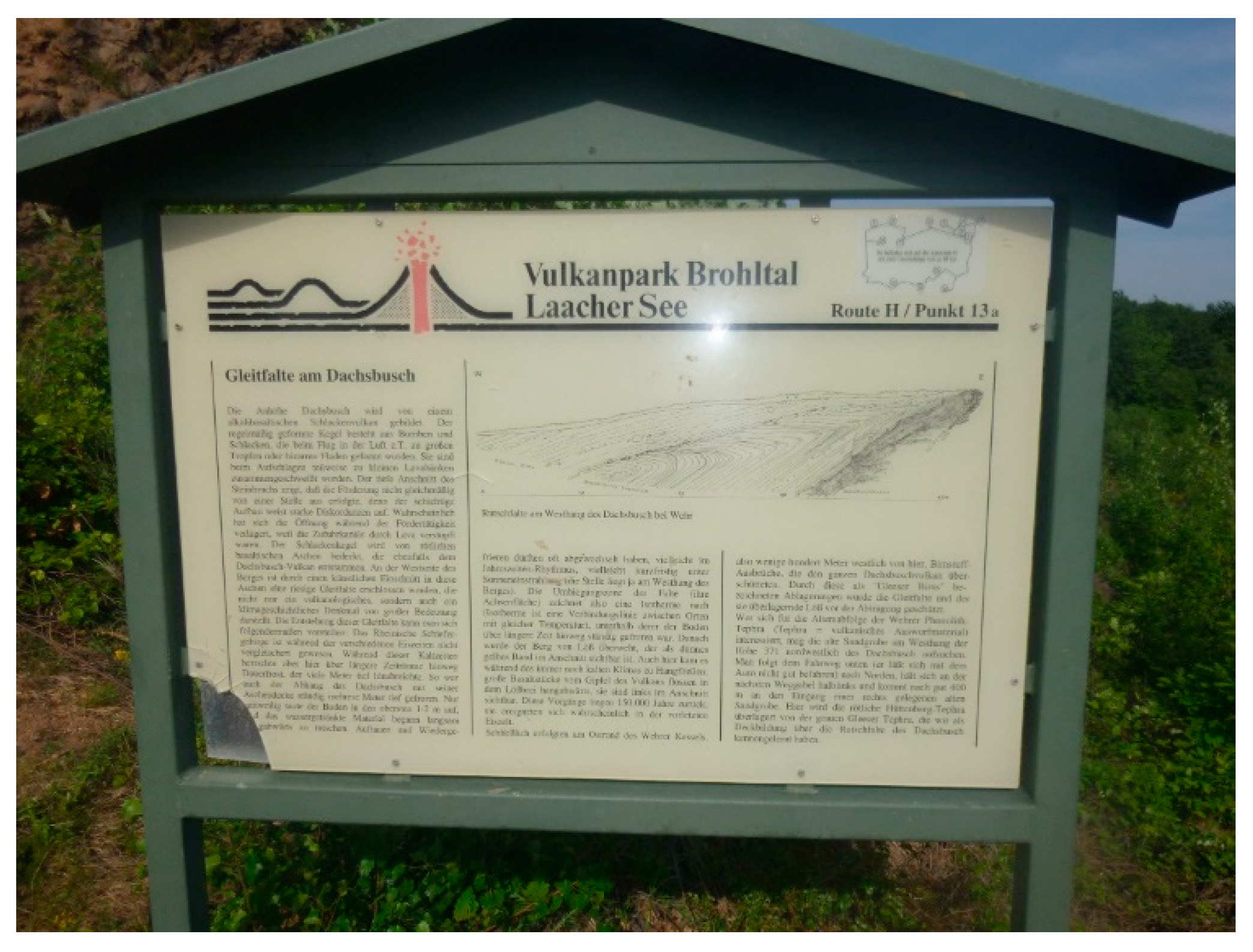
3.1. Geopark Vulkaneifel and Geopark Laacher See as Examples of an Intensive Valorization of Tertiary Volcanism

The Eifel (see Figure 1) was shaped by intensive Tertiary volcanism. Germany’s youngest volcano, the Ulmen Maar, can be found here as well as around 350 other volcanoes, maars, lava flows and numerous mineral springs [29] as well as the highest cold water geyser in the world, located near Andernach. The term “Maar” was coined in the Eifel in the early 19th century during a dispute between Neptunists and Plutonists about the formation of these maars. This made the West Eifel known internationally as a classic maar area [20]. The German Vulcanological Society was founded in Mendig (Eifel) in 1987. The aim of this society is to arouse interest in volcanism by promoting science, research, and education, and to deepen knowledge through excursions, publications, and other activities for scientists but also for a lay audience [37].
Characterized by barren agriculture and without any notable industry, the Vulkaneifel was an economically weak region. After the Second World War, attempts were made to establish tourism. For this purpose, the volcanic heritage was seen as an ideal unique selling proposition [38]. As early as the end of the 19th century, Rudolf Blenke described the Vulkaneifel and especially the area around the Laacher See as a major tourist attraction, because of the volcanoes and declared, “that it would be difficult to find another equally interesting region anywhere else in Germany”. A few years later (1884/1888), Johann Baumgarten published two travel guides on the volcanic attractions of the Eifel [39]. The region’s volcanic heritage had been actively valued since the late 1980s [40]. In 1984 the Hillesheimer Geopath was opened as a pilot project. The volcano museum in Daun followed in 1996 [25].
In 2016, the former Vulkaneifel Geopark was divided into two independent Geoparks. The western part, which had been recognized as a UNESCO Global Geopark, kept the name Vulkaneifel, while the eastern part became the Geopark Laacher See [41]. Since many of the activities date back longer than 2016, the two Geoparks will be considered here as an entire region.
The “Adventure of Volcanism” is valorized intensively and with great visibility. The Eifel is perceived as the “land of maars, geysers and sleeping volcanoes” [42]. Despite the activities of the other German volcanic regions, volcanism in Germany is mostly associated with the Eifel. This also applies internationally. Although Germany is not integrated as a volcanic destination, Erfurt-Cooper [16] lists the Eifel Museums in Daun, Manderscheid, and the Strohn Volcano House, as well as the Vulkaneifel Geopark as the only German example of volcanic geoparks.
Geotourism offers include both on-site and indoor offers, i.e., trails and panels, guided walks, informative leaflets and museums. “Volcanic storytelling” shall bridge the gap between science and society [43]. Also integrated are (historical) economic uses of volcanic material, such as the extraction of millstones or the underground quarries (“lava caves”) that were later used as cooling cellars for local breweries (e.g., in Mayen) [39]. Today, guided tours to the deepest beer cellar in the world are offered here to experience the “elemental forces of volcanoes” in the widely ramified basalt quarries and to convey what volcanism has to do with beer, thus “combining interesting facts with pleasure” [44].
To connect the two Geoparks, the German Volcano Road (Vulkanstraße) was created in 2006 as a common tourism marketing tool that covers both parts of the Vulkaneifel. However, a few years later this proved to be less effective than expected. More than a third of the visitors surveyed at museums along the Vulkanstraße had never heard the term before and almost half did not know that the museums are part of this road [25]. This coincides with surveys by Clement [45]. 88% of the people interviewed by him in the Vulkaneifel Geopark were in principle interested in geothemes, especially in self-guided trails and specific museums, but mostly learned about the offers only through the survey. Even the comprehensive surveys of Schmitz [38] did not show any changes. Nearly 75% of those questioned were not familiar with the Vulkaneifel Nature and Geopark, although they had been questioned within the Geopark. Even among the hosts within the Geopark, only slightly more than half of them knew it [38].
With over 10 million overnight guests and numerous day visitors, the Eifel is an important destination in Germany. Surveys by Kagermeier [25] showed that the geotouristic museums Daun, Manderscheid and Strohn only attracted a relatively limited number of Eifel visitors. Visitors were much more satisfied with the interactive elements, on condition that they worked well, while the traditional concept of the Vulkanmuseum Daun was not highly estimated.
In the course of time, adjustments were made to newer didactic findings. The youngest museum (Strohn) is designed to be much more interactive than the more traditional museum in Daun. In 25 years, the Geopark has also passed through three generations of information and nature trail boards. While the oldest ones had an extensive wording of more than 1000 words (see Figure 3), the second generation al-ready reduced the text volume to half but added colorful pictures, and the newest boards only contain about 200 words but in three languages [43].
Erfurt-Cooper [39] classifies the Eifel as one of the most successful tourist destinations in Germany, mainly due to the comprehensive geotouristic marketing of the volcanic landforms. The “Eyes of the Eifel” (aerial photos of the water-filled maars) are “probably the best known landscape feature having been used first as a unique selling proposition”. Schmitz [38], on the other hand, considers the potential to be by no means exhausted at the moment, despite the intensive connection between volcanism and the Geopark Vulkaneifel, numerous tourist offers, and a corresponding marketing strategy.

3.2. Geo-Nature Park Bergstraße-Odenwald as an Example for a Low Geotouristic Valorization of Volcanism

The Bergstraße-Odenwald Geo-Nature Park focuses its activities mainly on its non-volcanic features. In the short presentation [29] volcanic landforms are not mentioned at all; they can only be found on the homepage with a targeted search. This is quite astonishing, since the Katzenbuckel, the highest mountain of the Odenwald, has a volcanic origin from the Cretaceous period [20]. The Katzenbuckel was awarded “Geotope of the Year” in 2013. The “Path of Crystals”, a 1.5 km long nature trail, leads to the summit and explains the formation of the mountain and its various outcrops in ten stations. According to Simper [46] the Katzenbuckel is thus the volcano with the best geological interpretation in Germany. Nevertheless, the Geopark lists the “path of crystals” as a mineralogical nature trail and the Katzenbuckel as the highest mountain of the Odenwald, but neglects all hints of volcanism [47].
The world-famous Messel Pit is also located within the Geopark area, but is managed independently. Since 2010, there has been a visitor center and museum, which is visited by an estimated 100,000 persons per year. In addition, guided tours and self-guiding elements such as information boards and a viewing platform are offered. The volcanic formation is mentioned, but the focus is on the fossil finds [48].

3.3. Geotouristic Valorization of Volcanism Outside of Geoparks

Even outside of recognized geoparks there are examples of geotouristic valorization of the volcanic heritage. A good example is the Vogelsberg region (Hesse), for which an application process is currently under way to be recognized as a National Geopark.
Further examples are the Kaiserstuhl and the Hegau volcanoes in Baden-Wuerttemberg (see Section 4.2 and Section 4.3). Geological and hiking guidebooks also integrate excursions to volcanic landforms in the corresponding regions for a specialist audience or, in some cases, an interested lay audience [46].
In 2004, the Academy of Geosciences launched a Germany-wide competition to award the most important geotopes of the Federal Republic of Germany as so-called National Geotopes. From 180 submitted proposals, 77 National Geotopes were selected [49]. Of these 77 geotopes, 19 show a volcanic origin—see Table 2. Some of these geotopes are located within Geoparks.

4. Case Study Southwest Germany

The geological map of southwest Germany shows four large units with different dates of origin. The crystalline basement is built up by igneous and metamorphic rocks of Paleozoic age. The overburden consists of a wide variety of sediments, ranging from Permian to Jura, forming a cuesta landscape. The Upper Rhine Rift is filled with massive sediment deposits, mainly from the Pleistocene. The alpine foothills are covered with thick molasse layers. Lake Constance and its surroundings were extensively shaped by glaciation during the Pleistocene. Southwest Germany has a global importance for geologists due to the two meteor craters (Nördlinger Ries and Steinheimer Becken), the world-famous fossil sites (e.g., Holzmaden), the research of Jurassic stratigraphy by Friedrich-August von Quenstedt and of Ice Ages by Albrecht Penck, and finally the archeological sites of homo heidelbergensis and steinheimensis [51].
During the Tertiary, volcanic phenomena were observed in several places in what is now Baden-Wuerttemberg. This was the case in the Rhine Rift Valley, where the Kaiserstuhl in particular should be mentioned, the Hegau volcanoes west of Lake Constance and the Urach-Kirchheim volcanic area (Swabian Alb) (see Figure 1, Figure 4, and Figure 5). Volcanism, which reappeared for the first time since the Permian, is related to the intensification of the tectonic processes during Alpine orogeny and the formation of the Rhine Rift Valley (see below).
A survey of geotopes worthy of protection and those actually protected in the four administrative districts of Baden-Württemberg shows two important findings: Volcanic landforms generally make up only a very small proportion of all geotopes recorded. Of 2856 mapped geotopes, 102 had volcanic origin. This corresponds to a share of just 3.6%. Moreover, 54% of the volcanic geotopes are protected, 46% were principally worthy of protection, but without their own protection status [52,53,54,55]. However, volcanic geotopes share this problem with almost all other geotopes, as geotope protection in Germany is still a stepchild of nature conservation [56].
Most laypeople are not aware that there are volcanic landforms in Baden-Württemberg at all. Considering the rich geology of Baden-Württemberg and the singularity and small size of Tertiary volcanic landforms, they are only prominent in areas like the Hegau, where they can be also clearly identified visually. Mostly unspectacular volcanic landforms like in the Geopark Swabian Alb (see Section 4.1) are usually not recognized as such by a lay audience. A sound and professional valorization is therefore very important for both geotope protection and geotourism.

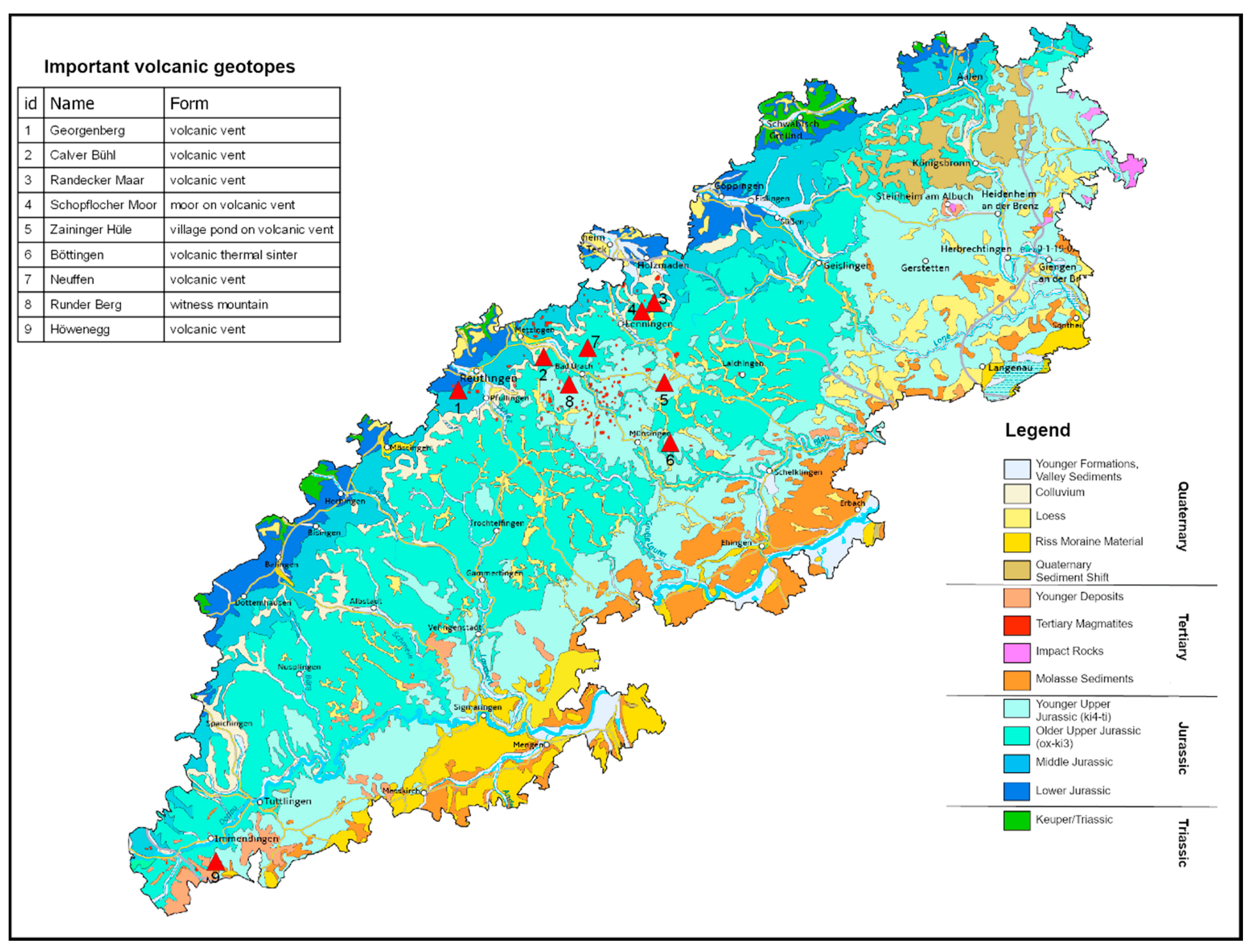
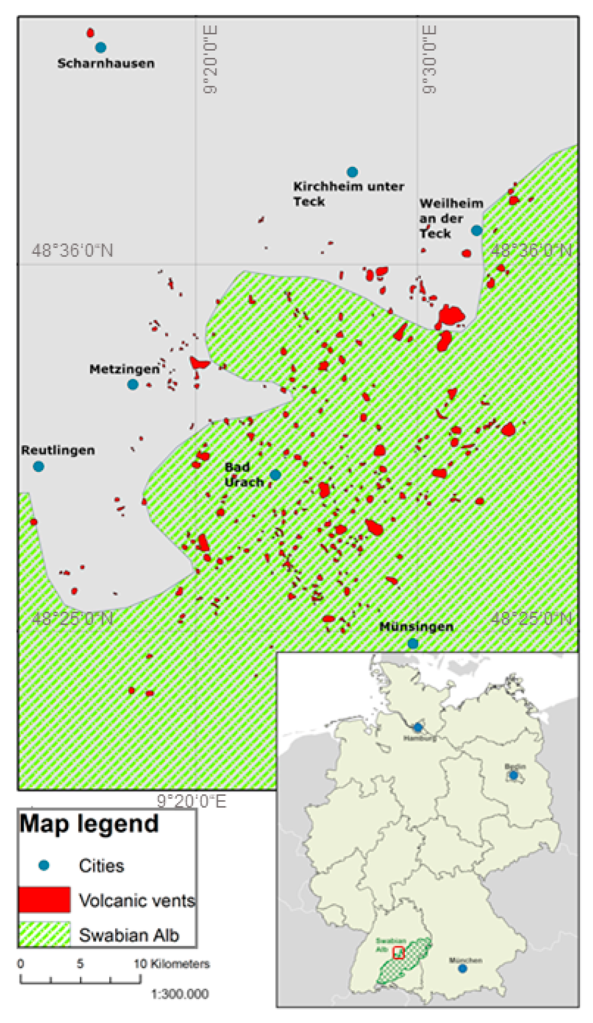
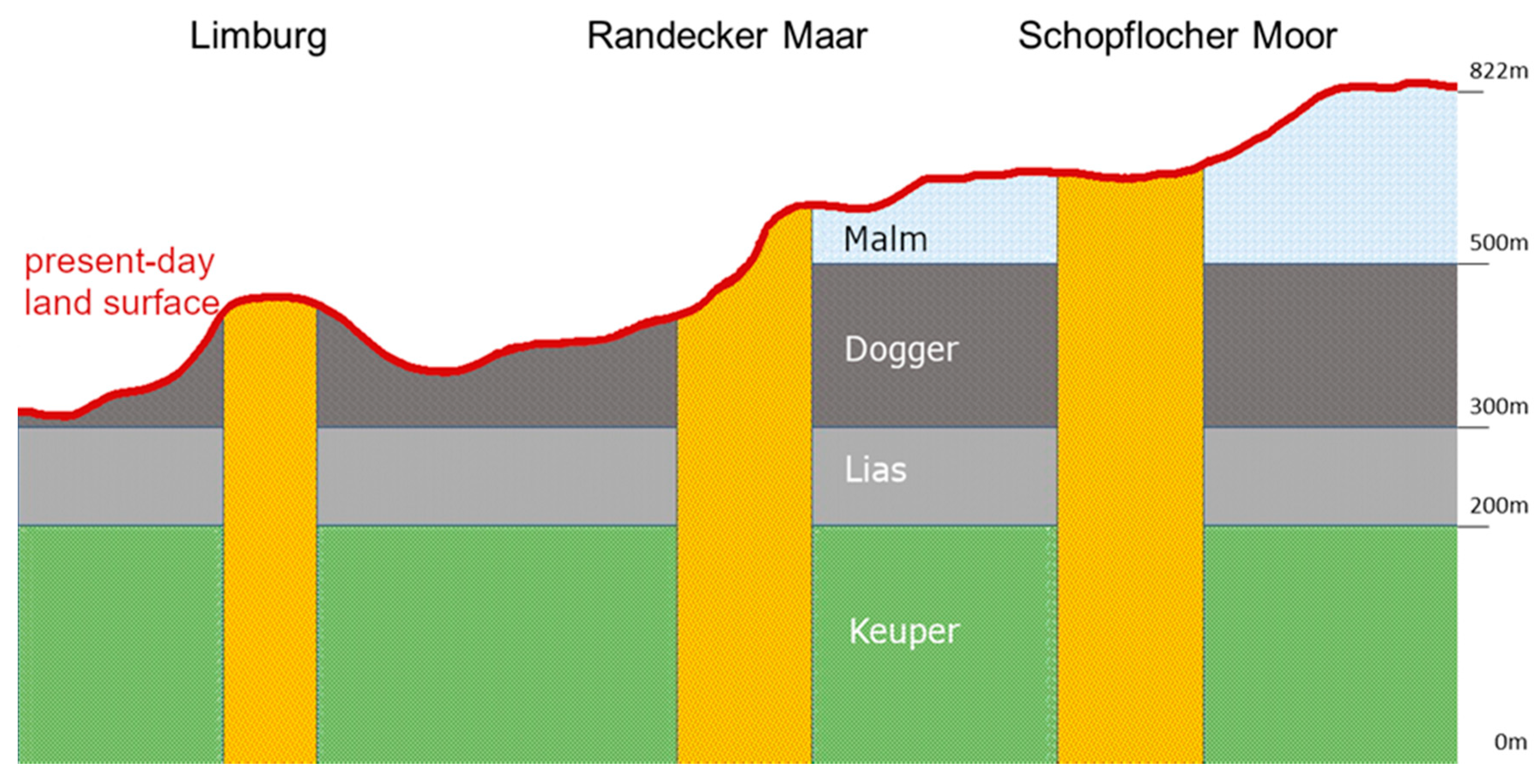
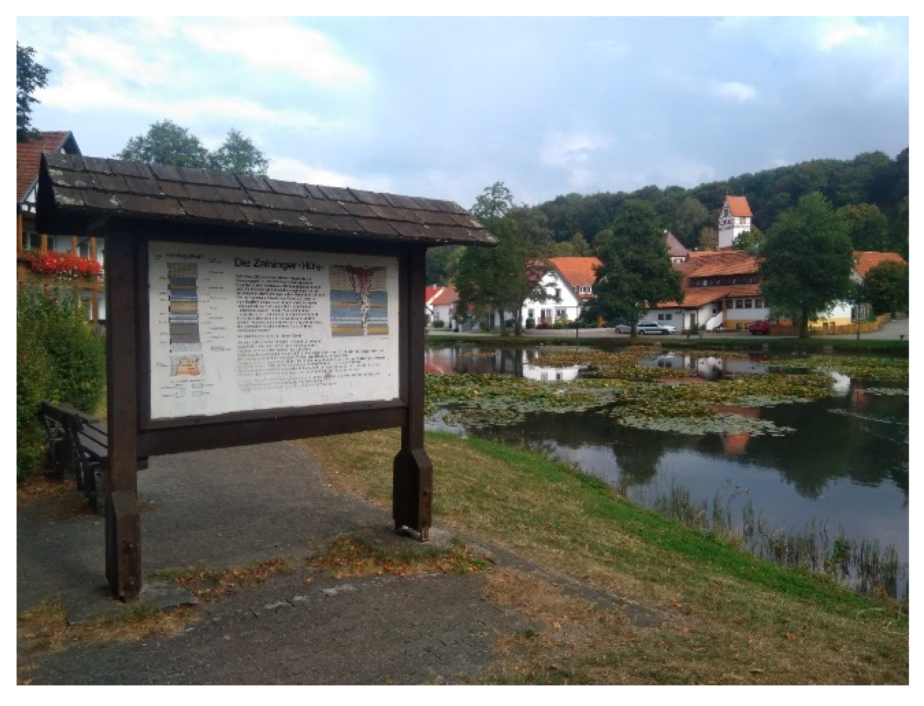
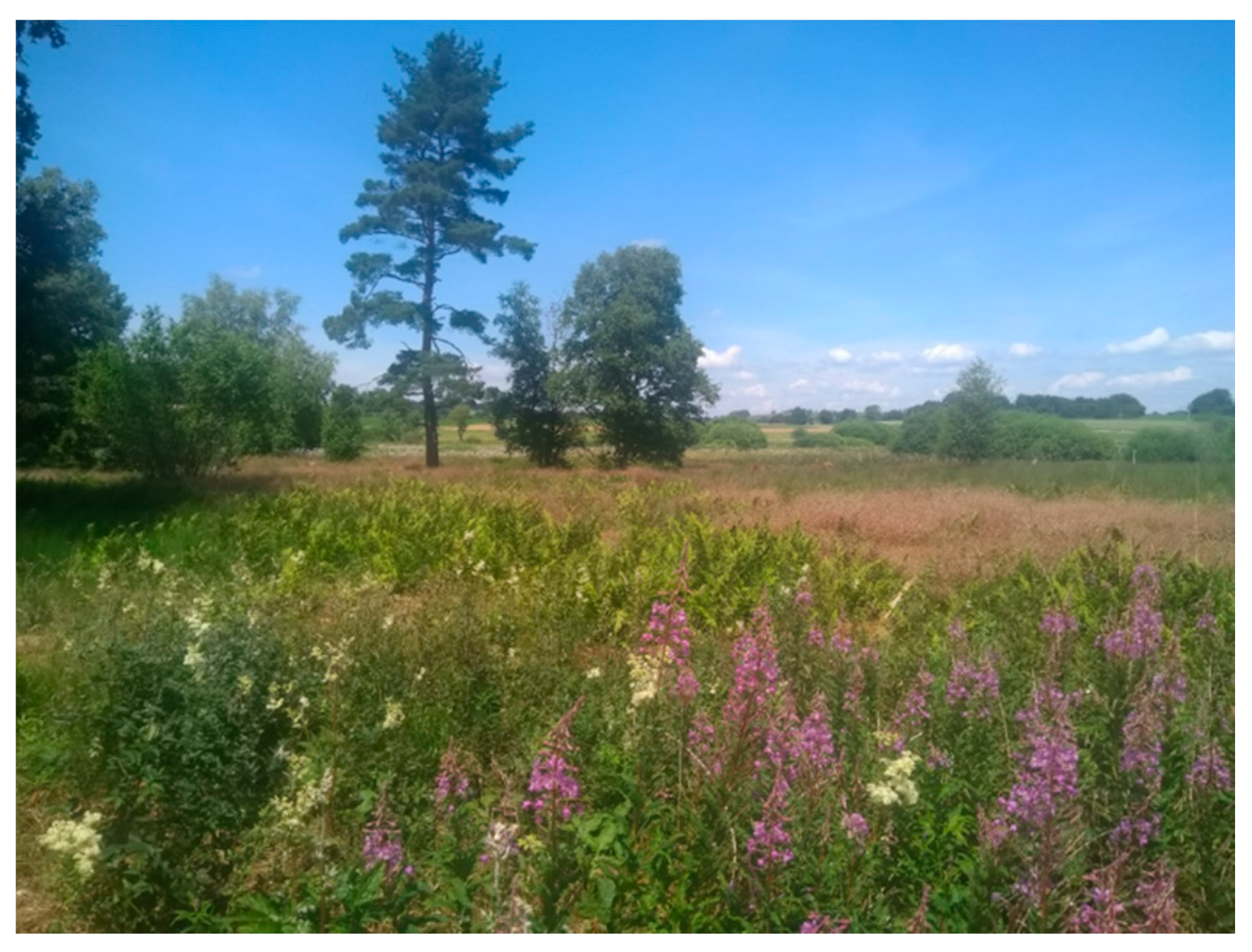
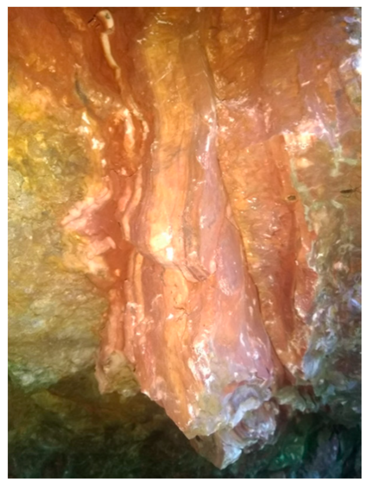
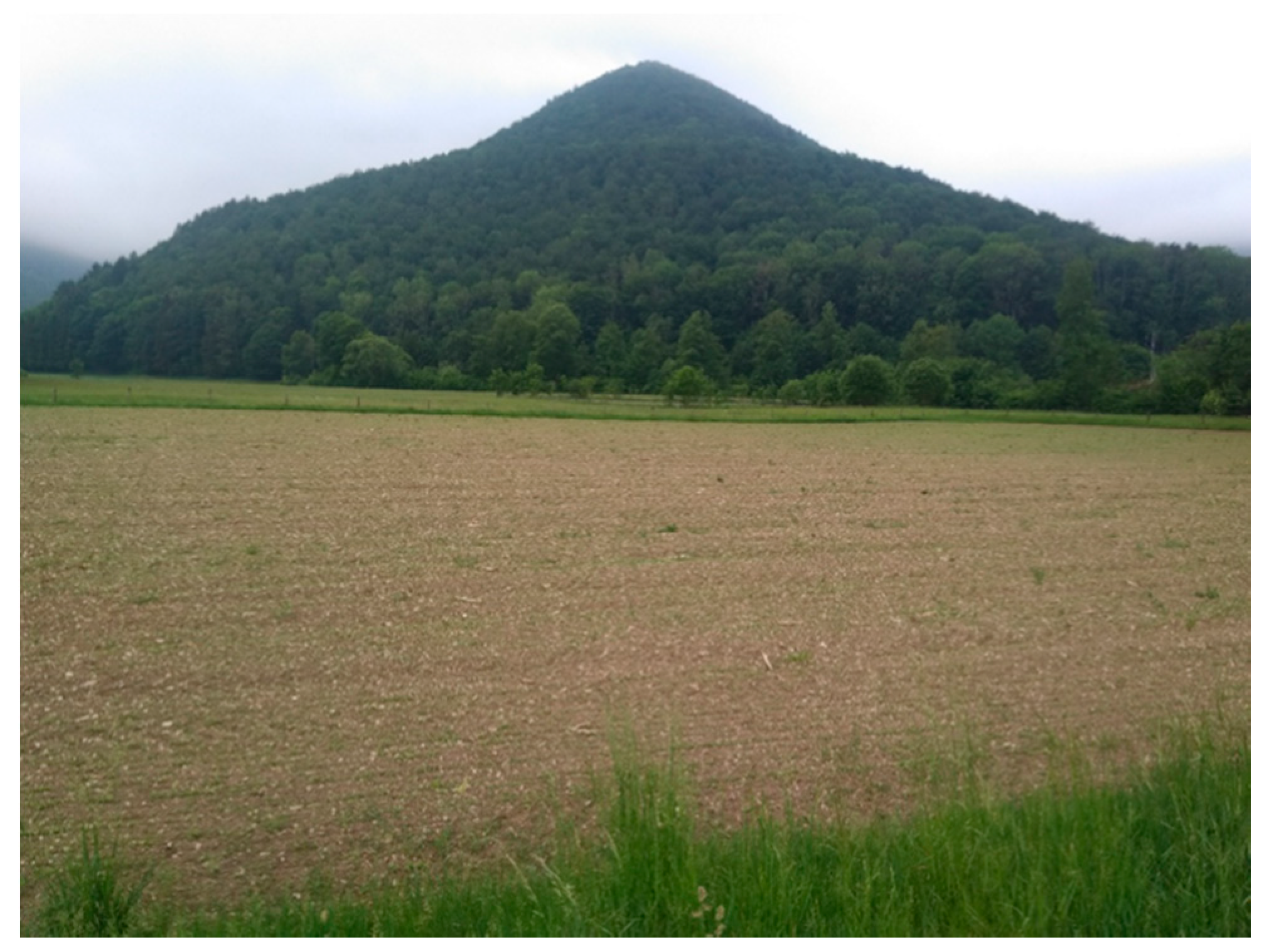
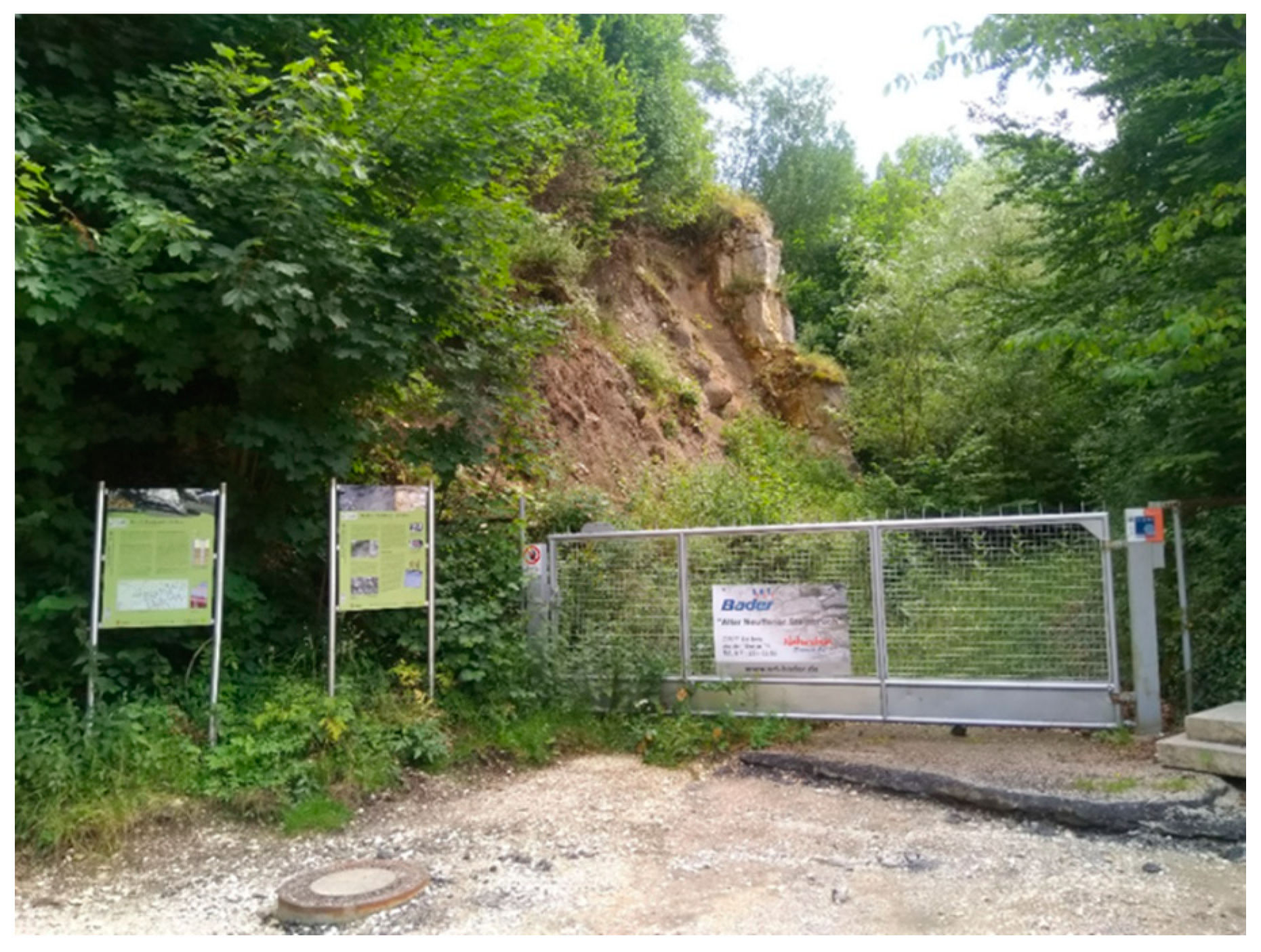
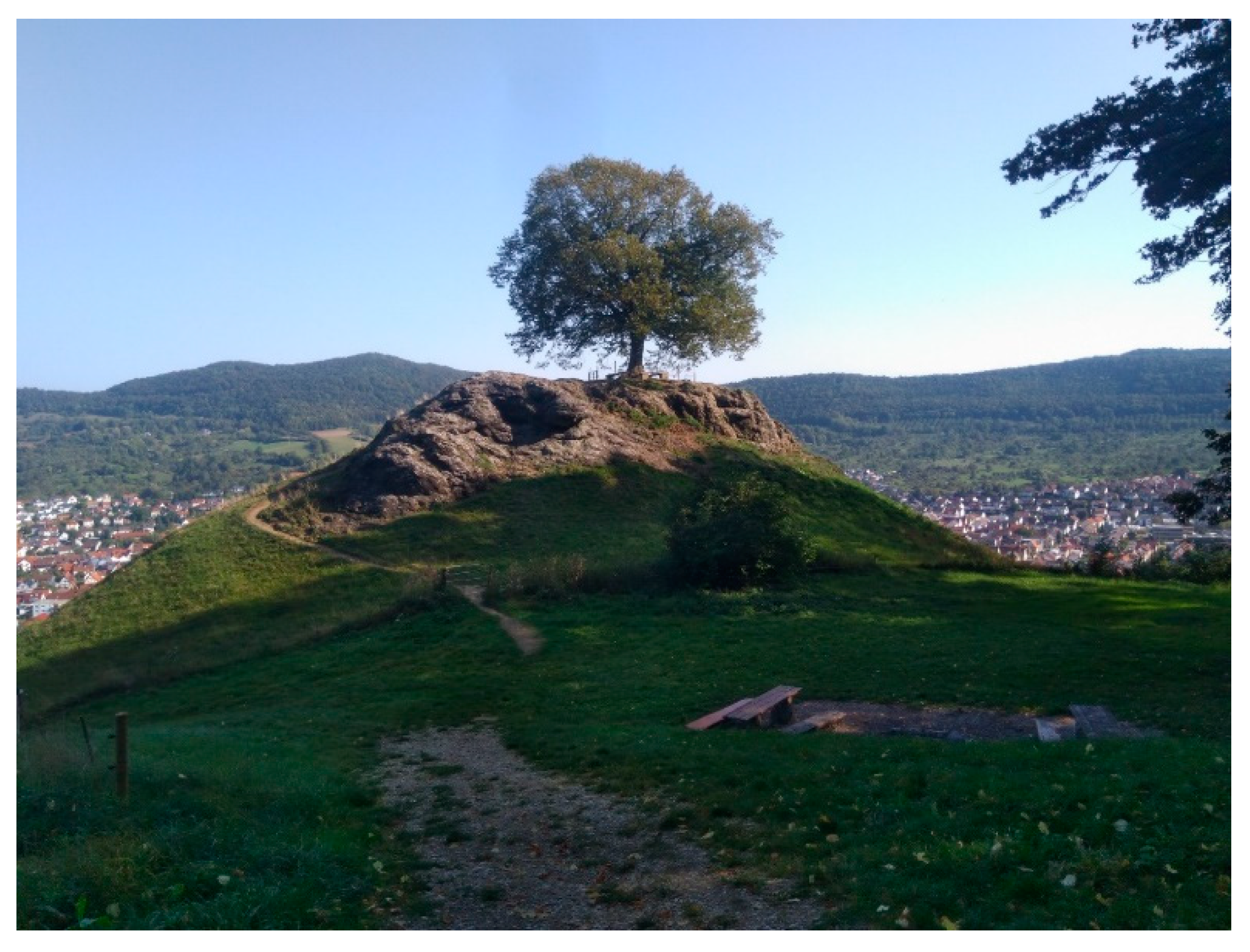
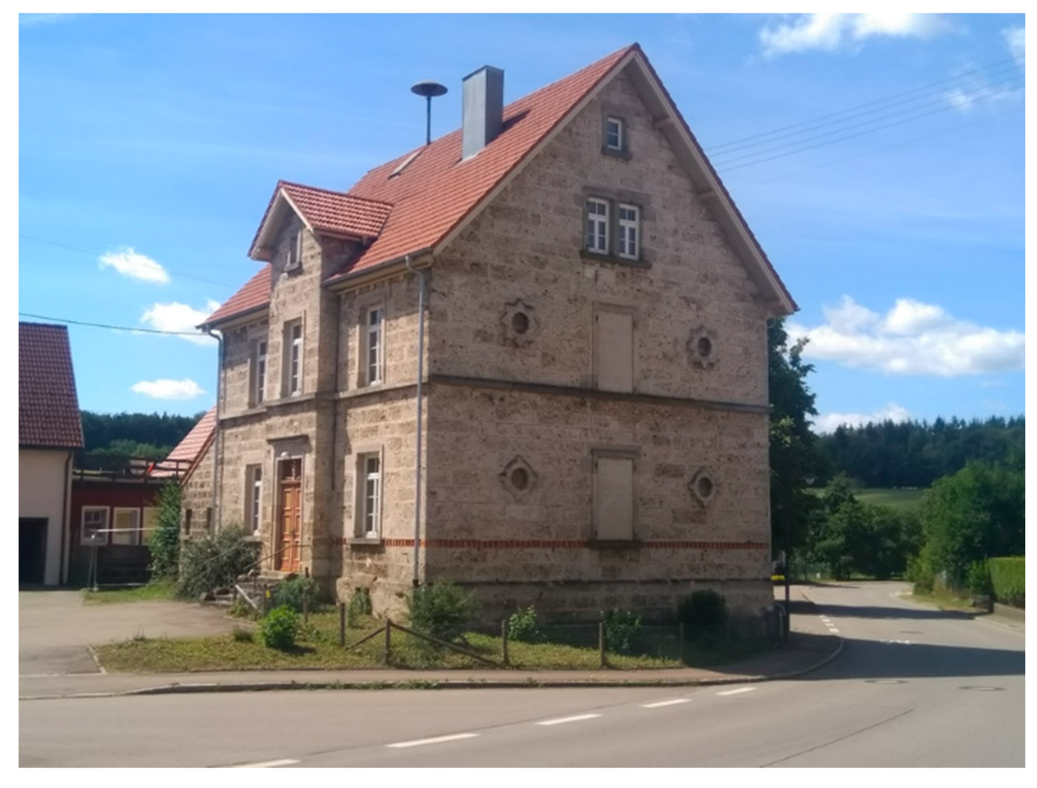
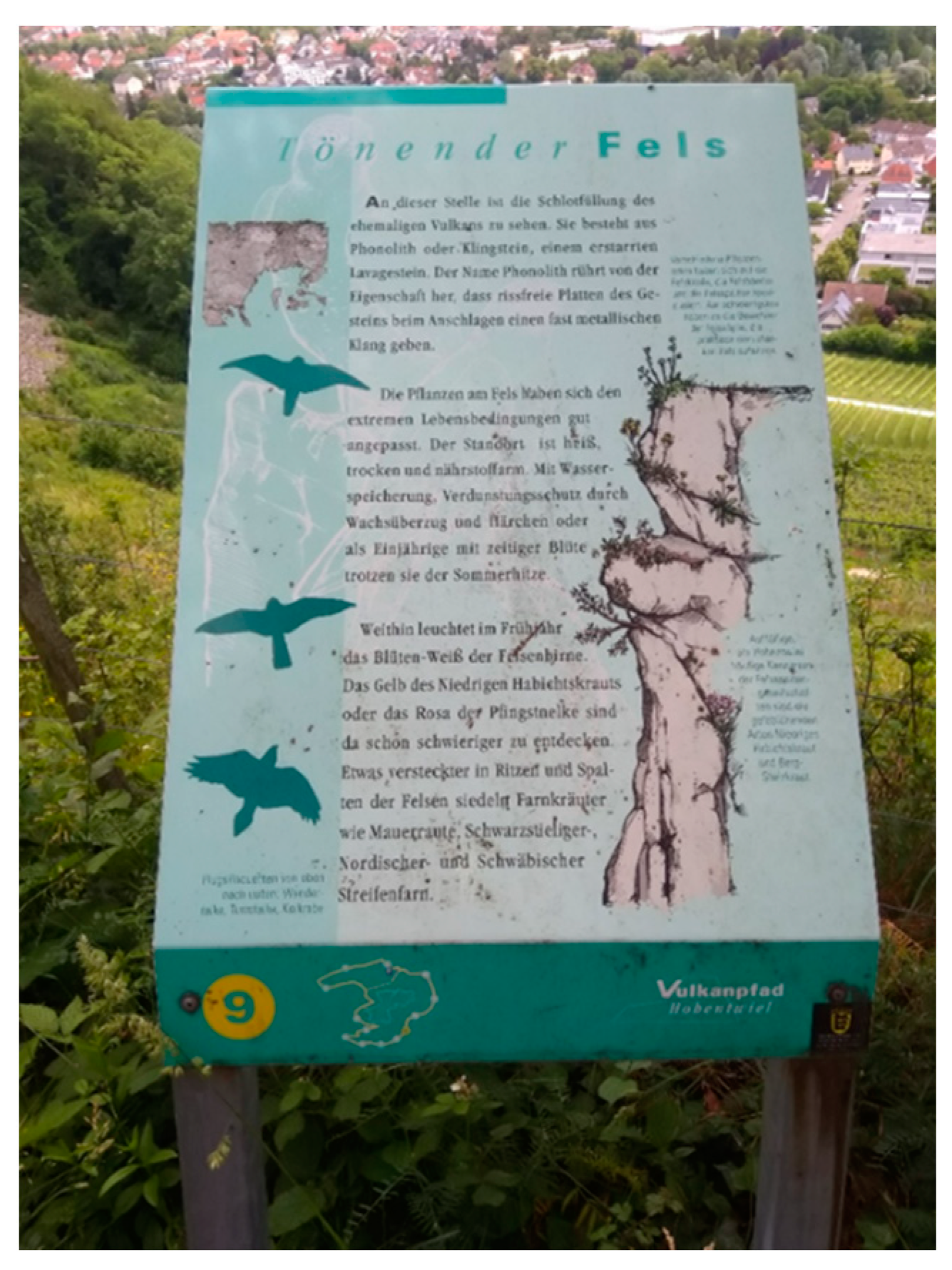
4.1. UNESCO Global Geopark Swabian Alb—A Well-Camouflaged Potential

The Geopark Swabian Alb was founded in 2000. In 2002 it was recognized as a National and European Geopark; in 2015 as a UNESCO Global Geopark.
With an area of around 6,200 km2, the Geopark integrates almost the entire Swabian Alb, a low mountain range, mainly characterized by limestone deposits from the Jurassic period (Figure 4). The Swabian Alb is the largest karst area in Central Europe and the cave-richest region in Germany with over 2800 documented caves. The caves played a decisive role in the Aurignacien period. The oldest prehistoric sculptures (Löwenmensch and Venus vom Hohle Fels) as well as the oldest musical instrument were discovered here [57]. Since 2017 they have been protected as UNESCO World Heritage Site “Caves and Ice Age Art in the Swabian Jura”. The two meteorite craters are another world-famous highlight. The larger one is in Nördlingen in the Ries Geopark, the smaller one in the Steinheimer Basin in the Geopark Swabian Alb.
Another special feature, which is usually little noticed outside geological expert groups, is the so-called Swabian volcano, today usually referred to as the Urach-Kirchheim volcanic area due to the location of the magma chamber (Figure 5). The main period of activity can be dated to the Miocene. Due to the predominantly pyroclastic rocks, it had been an explosive volcanism, i.e., rising hot magma came into contact with groundwater (phreatomagmatic processes) [20]. This also explains why, in contrast to the Vulkaneifel, on the Alb there are neither lava flows nor mighty layers of tuff. Instead, over 360 volcanic vents have been mapped (see Figure 5), most of which are only a few hundred meters in diameter, some of which have not even reached the surface. With an area of 1600 km2, the Swabian volcano is one of the most important tuff vent areas on earth [22]. The northernmost volcanic vent is near Scharnhausen (see Figure 5). For more than a century, the shift back of the Jura strata was calculated on Malm rocks found in this vent. It was only in 2018 that Schweigert [58] was able to prove that these rock fragments originate from Lias.
Due to the different hardness of the volcanic rocks and the surrounding materials, the volcanic vents in the Alb foothills were prepared as hilltops, while on the Alb plateau they form depressions embedded in the relatively hard malm layers (Figure 6).
The water-impermeable volcanic rocks were essential for settlement development. Due to karstification the Swabian Alb is the most arid region in Germany despite high precipitation. Many settlements were therefore located at volcanic vents. In some cases, a village pond (local name: Hüle) was created on this rock (see Figure 7), which served to supply the farm animals, but occasionally also the people.
The largest volcanic vent with a diameter of over one kilometer is the Randecker Maar. As a fossil site (in the former lake sediments) it became known to experts worldwide [59]. In the immediate vicinity of the Maar is the Schopflocher Moor (Figure 8), the only moor on the arid Alb. The maar sediments of Höwenegg are another internationally significant fossil site. Particularly noteworthy are the findings of relatives of the Hipparion genus, as well as water musk deer, fork deer, and rhinoceroses [22].
The so-called Böttinger marble also became reknowned as a fossil site as well as a sought-after building block. Formed by chemical precipitation from thermal waters, the marble is characterized by alternating light and red bands (Figure 9) [60]. Petrologically, it is no marble, but a special form of thermal sinter [61]. The naming comes from the earlier usage. Among others, the interior design of the King’s Palace in Stuttgart was decorated with Böttinger marble.
To this day the Urach-Kirchheim volcanic area is characterized by a geothermal anomaly. The geothermal depth is sometimes only a third of the usual values. This allows the exploitation of thermal water and the installation of thermal baths (Bad Urach, Beuren) [20].

Geotouristic Valorization of Tertiary Volcanism in the UNESCO Global Geopark Swabian Alb

The Swabian volcano aroused the interest of scientists very early on. Its volcanic origin was already discovered in the 18th century. At the end of the 19th century the first detailed monograph about the “largest maar area on earth” was published, at that time with 125 volcanic vents listed [22]. While scientific research was ongoing, the Swabian volcano was less noticed by the general public. Local volcanic geoheritage was “little known and always surprising” [59]. This might be due to the fact that the weathered crests and cones in the foothills of the Alb are not recognized as volcanic landforms by most laypeople, and that many of the volcanic vents are covered by debris and thus elude direct observation. Only magnetic field measurements can detect these vents [22]. The search for volcanic shapes therefore requires some intuition [59].
If it is known that volcanism existed in the area, then laypeople often refer to prominent witness mountains such as the “Runde Berg” near Bad Urach or the “Achalm” near Reutlingen as volcanoes, since they have a similar shape to a “classic volcano” (Figure 10). On student excursions in Bad Urach, such statements are the rule.
The UNESCO Geopark Swabian Alb focuses on a combination of individual geological highlights, some so-called geopoints equipped with information boards (Figure 11), museums that present geological contents, educational and adventure trails, guided tours and special campaigns, such as the “Day of the Geotope” every year in September.
The starting point of geotourism was the brochure “Adventures in Geology” [62], published in 1999, in which for the first time the geology of the Swabian Alb was prepared for a lay audience. A separate chapter “Volcanoes erupt, meteorites strike” was devoted to Tertiary volcanism. This brochure, which in a way represented the initial spark for the Geopark, has now been published in its 11th edition and has achieved widespread circulation with over 100,000 copies.
The basis for the geotouristic valorization was the survey of geotopes in Baden-Wuerttemberg, classified as worthy of protection. Based on this, 438 geotopes within the area of the Geopark were recorded in detail, taking into account accessibility, current use, condition and endangerment [63]. Possibilities for geotouristic valorization was not in the main focus. A proposal for a qualitative assessment of sites of geological interest for geotourism promotion as well as geoconservation was presented by [64]. A comprehensive and scientifically sound assessment of the geotouristic values of selected geosites as done by [13,14,65,66] is unfortunately still missing, as is a SWOT analysis (Analysis of Strengths, Weaknesses, Opportunities, and Threats) on the development of geotourism in the geopark.
Geotouristic valorization of volcanic geoheritage is still significantly underrepresented in the Geopark Swabian Alb. On the homepage, caves and fossil sites are promoted as interesting places to visit, but no volcanic landforms. In the special “Geoparks” issue of Bild der Wissenschaft, the Geopark presents itself as “Jurassic Park in Germany”. On the five-page presentation, the volcanic geoheritage is not mentioned once, and no volcanic landform appears among the highlights listed [35]. This applies analogously to the illustrated book “Vulkane, Schluchten und Höhlen” [42], in which the Swabian Alb is likewise reduced exclusively to fossils, strata and the meteorite impact.
Of the current 26 geopoints, which are supposed to represent a selection of the geotourism highlights, only two are volcanic landforms (Höwenegg volcanic crater and Neuffen volcanic vent) (Figure 11).
The 39 outstanding geotopes presented on the homepage, integrate only four geotopes of volcanic origin. In addition to the two geopoints mentioned above, the internationally important Randecker Maar and the closely related Schopflocher Moor are added. Of the 22 nature trails listed on the homepage, only one (Volcano crater circular trail—Vulkankraterrundweg Münsingen-Apfelstetten) deals with volcanic heritage. Of the 24 listed guided tours, not a single one valorizes volcanic geoheritage. Even for the guided tours of the Nature Conservation Center Schopfloch, in direct vicinity of the outstanding volcanic landforms Randecker Maar and Schopflocher Moor, the term “volcanism” is not mentioned at all. This applies analogously to the 42 listed museums as well as the official map of the Geopark. The Geopark cooperates with schools and offers support for school trips and excursions. Special educational material on volcanic geoheritage has not yet been elaborated.
Volcanic landforms, such as the weathered volcanic vents in the Alb’s foothills, are mostly without any information on site that could explain the volcanic formation to a casual visitor. This applies among others to the Georgenberg, a striking hilltop on the outskirts of the city of Reutlingen with a viewpoint that attracts numerous visitors as well as the Calver Bühl (Figure 12). This would be a good opportunity to draw attention to the Swabian volcano without great efforts.
In 2003 the geotouristic map for the National Geopark Swabian Alb was published. This map, which is supplemented by a detailed booklet, lists geotouristic destinations including museums, educational and adventure trails, nature conservation centers and selected geotopes. For each geotope listed, the booklet contains information on the location, accessibility and geological features. Of the 38 listed museums, only one deals marginally with volcanic geoheritage; of 19 nature trails also only one. Of 79 listed out-crops, 8 are of volcanic origin, of 83 landforms only four [67]. The selection seems somewhat arbitrary. Some volcanic landforms are mentioned, others not. Contrary to the geotouristic map for the Black Forest [68], which was published one year later, no general information about the Geopark’s geology was integrated. A keyword search therefore is not possible. The short scientific texts make it even more difficult for laypeople to use the map. For the outstanding Geopoint “Höwenegg” for example only the Miocene basalt tuff is mentioned. A reader who is not familiar with the technical terminology may completely overlook the volcanic formation.
The combination of didactically inadequate texts with incorrect assignments is particularly problematic. The trail board of the Sternberg’s nature trail does not take into account any of the required criteria for a professional heritage interpretation (see Section 5.1) and was unfortunately set up in front of dolomite rock and not at the aforementioned volcanic vent [69].
In 2003 the popularized hiking guide “Vulkanalb” [59] was published. 16 thematic hiking trails allow recreational visitors to discover the geoheritage. A new and updated edition appeared in 2016. Numerous other hiking guides also integrate volcanic phenomena, but in contrast to [59], only as one aspect among many others. Mostly, the particularly striking volcanic formations are integrated, especially the Randecker Maar. This applies analogously to geological field guides, which usually integrate some excursions. In contrast to the hiking guides, these books (e.g., [70,71]) are aimed more at a professional audience.
A comprehensive strategy for the geotouristic valorization of the Tertiary volcanic phenomena does not yet exist in the Geopark Swabian Alb. First ideas on a “volcanic route”, which combines different volcanic phenomena, are currently being discussed. The starting point could be the Münsingen suburb of Böttingen, where an older, currently vacant school building could be converted into a volcano museum and visitor center (Figure 13). Together with an interpretation concept for the nearby former quarry of Böttingen marble (Figure 9), this could be the first step for the valorization of the volcanic geoheritage.
In the foreseeable future, the signage of further volcanic geopoints is planned: Randecker Maar, Aichelberg and Calver Bühl (Figure 12), two volcanic vents in the Alb foothills, and the Hüle (village pond) in Zainingen (Figure 7), which points to the great importance of waterthawing volcanic rocks for the settlement development on the karstified Alb. Due to corona restrictions, several awards already planned for 2020, have been postponed to 2021. This also concerns the planned exhibition “Otto Mäusnest—Erforscher des Schwäbischen Vulkans” (Otto Mäusnest—Reseacher of the Swabian Volcano), which was to open in spring 2020 at the Biosphere center.
In addition to volcanic landforms, a stronger valorization of fossil sites is also worthwhile. Some of these are of international importance (Randecker Maar, Böttingen quarry, Höwenegg) and could reach other target groups. In the longer term, the Swabian volcano is to be included in the “Route to the Volcanoes of Germany” (see Section 3.1) [34]. As volcano geotourism is still underdeveloped in Geopark Swabian Alb, sharing experience and learning about good practice is especially important. Examples from other German Geoparks like Vulkaneifel or Bayern-Böhmen could be very helpful, as well as strategies from foreign regions, like the “Land of Extinct Volcanoes” in Poland, Bohemian Paradise (Czechia), Novohrad/Nógrád (Slovakia, Hungary) and Bakony-Balaton (Hungary) [13,14,15].
The Swabian Alb is one of the most important tourist regions in southern Germany. In 2016, it recorded 75 million day trips and 5.3 million overnight stays by tourists, thereby gaining a tourism added value of € 2.8 billion [72]. The twelve show caves of the Swabian Alb recorded 320,000 visitors per year [73]. Nevertheless, the Baden-Württemberg tourism concept criticizes the “under-utilization of the Geopark for tourism and the actual positioning in the market which does not correspond to the potential”. The Geopark Swabian Alb therefore adopted a master plan [74] that listed the most important fields of action, including the development of the geotope management concept [63], which is the decisive instrument to ensure the compatibility of geotope protection and geotourism. The valorization of volcanic landforms could bring more visitors to the Geopark. A stronger networking of the different actors in the Geopark and the development of a common strategy are crucial here. The outstanding guide “Vulkanalb” [59], for example, contains no references to the Geopark apart from the logo. The cooperation with the UNESCO biosphere area, which is located completely within the Geopark’s territorial delimitation, is still upgradable [75]. At important geotopes like the Neuffen volcanic vent, the Biosphere reserve set up information panels without even mentioning the Geopark.

4.2. Kaiserstuhl—Isolated Volcano with Viticulture

The Kaiserstuhl (Figure 1) is a volcanic ruin, originating 13–18 Mio. years ago [61], which is located at the intersection of two important fault zones. Since 80% of its surface is covered by loess today, the volcanic rocks are only exposed in a few places [20]. The good suitability for viticulture led to the construction of terraces very early on. In the course of an extensive land consolidation, these small structures fell victim to enormous, intensively agriculturally used large terraces. Although the rather small (15 by 12 km) and low volcano (557 m) is clearly visible as a landmark from afar due to its exposed position in the broad plain of the southern Rhine Rift Valley [61], the volcanic origin of the Kaiserstuhl is hardly recognizable to laypeople.
Several nature trails provide access to the local geology, where the volcanic origin is only one aspect among many.

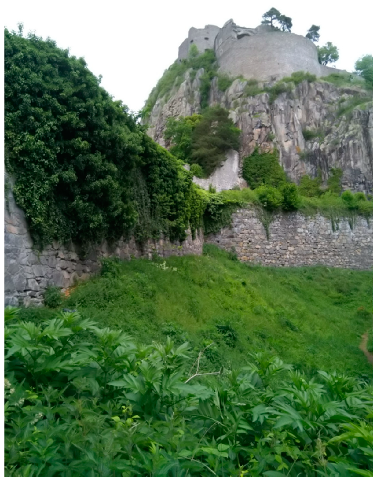
4.3. Hegau: Fire, Ice and Water; Volcano Trails and Tours

The Hegau volcanism took place 7–15 million years ago. Similar to the Alb’s foothills, volcanic vents are harder than the sedimentary rocks surrounding them [22]. During the Pleistocene, the basaltic and phonolithic volcano vents were strongly overshaped, most of the Hegau volcanoes overlooking the mighty glaciers as nunataks [20]. Today they form striking mountains, excellent building sites for castles (including the Hohentwiel fortress—see Figure 14). The embedding of the volcanoes in the molasse deposits leads to an impressive landscape, which is popularly known as God’s skittles [20].
A first attempt to geotouristically valorize the Lake Constance region was undertaken by an international team, including the author, in 2000. Based on the model of the brochure “Adventure Geology” (see Section 4.1), the brochure “Fire, Ice and Water” was intended to present the complex geology of the Lake Constance region in an exciting and vivid way for a lay audience. Under the headline “Etna and Vesuvius at Lake Constance” a popular scientific presentation of the Hegau volcanism is given [76]
Today, Hegau markets itself touristically as “Vulkan- und Burgenland” (Land of volcanoes and castles). Several hiking trails lead on and around volcanoes, like the 3 km long circular trail around the Hohentwiel (Figure 14). At the time of its inauguration, the path was a very good example of a successful implementation of heritage interpretation (see Section 5) [69]. Regrettably, the path was not maintained accordingly, such that the weather-exposed boards have visibly suffered in the meantime (Figure 15).
Unfortunately, this is not an isolated case. In a pilot project for cross-border geotourism, the map package “Vulkane im Hegau” (Volcanoes in Hegau) was developed, consisting of a double-sided printed map and two brochures. The package enables a lay audience to explore the Hegau landscape via various hiking tours. The demand was very positive, so that the first edition was sold out rather soon. A reprint or a revised new edition never took place, despite which Hegau tourism is still focusing on corresponding volcanic offers.

5. Resulting Requirements

Both in the Federal Republic of Germany in general and specifically in the southwest (State of Baden-Wuerttemberg) there is a high-quality volcanic geoheritage. In order to use this potential for geoenvironmental education and geotourism offers, the following aspects have to be considered:

5.1. Professionalization of Geo-Didactics, Geotourism and Geotope Protection

Geology generally held a subordinate position in environmental education for a long time. Only 3% of the educational trails in the Federal Republic dealt with geological topics [77]. Up until the 1980s, geological issues were hardly discussed outside of specialist circles; integrating the general public by providing information that was generally understandable was considered “unscientific” [78]. This began to change at the end of the 1990s in connection with the inauguration of the first Geoparks. Geoenvironmental education for laypeople was one of the main objectives [27]. Only in the 2000s the term “geodidactics” became established and was increasingly seen as important [79].
Geoenvironmental education should follow the guidelines of heritage interpretation, an educational activity, which aims to reveal meanings and relationships through the use of original objects, by firsthand experience, and by illustrative media, rather than simply to communicate factual information [80].
It is particularly important to consider the following points:
  • Awaken and maintain interest in geothemes.
  • Target group orientation.
  • Adequate mediation techniques, including understandable language.
  • Regional focus on local characteristics.
  • Take home message [6].
In the meantime, geology as well as methods of heritage interpretation are increasingly being integrated into the training courses of landscape guides, whereby the guides in the Geopark Swabian Alb today integrate geology in the vast majority of the offered tours [81]. Innovative methods for the valorization of geotopes were published by [7,82], among others. This has led to increasingly good examples of geotourism offers.
Outstanding examples of professional valorization of volcanism can be found in the geoparks of the Eifel, Bayern-Böhmen, and in the Vogelsberg volcanic region, among others. Innovative offers benefit from new technologies, such as film recordings or satellite images of current volcanic activity [83].
Nevertheless, there are still far too often “traditional” trail boards, sometimes with far too much text and a technical language incomprehensible to laypeople. Those panels can neither spark interest in volcanism nor sensitize for geotope protection. There is still some catching up to do in the Geopark Swabian Alb, where many volcanic phenomena are not provided with any information for the general public or in which the implementation is very inadequate (e.g., Sternberg).
Unfortunately, geotopes are still insufficiently protected. Geotopes that have no or insufficient legal protection can therefore only be maintained in good condition through a corresponding appreciation and awareness of their importance, but also of their vulnerability. Geoenvironmental education is therefore also of particular importance in promoting an understanding of the need for protection [84]. This is all the more true as the importance and value of geotopes is not only not well known to the general public, but even to other specialist disciplines [85]. Wardenbach et al. [86] even see a need for clarification among biologists and nature conservationists in order to achieve more acceptance for the “protection of dead rocks”. For volcanic landforms, this particularly applies to phenomena which are difficult to recognize for non-geologists.

5.2. Geotourism Offers, Regional Added Value and Geotope Protection

Tourism is generally a very important economic factor. Geotourism can be an important economic con-tribution, especially for peripheral regions with structural weaknesses [8]. Examples include the Sinter Terraces in Pamukkale (Turkey) [87], the US Mammoth Caves [4], and Terra Vita Geopark (Teutoburg Forest) [88]. For Ireland, INDE-CON [89] estimates the economic value added by geotourism and geoheritage at €660 million per year and 8750 jobs. However, the front-runners are Chinese geoparks, which attract over 2 million visitors per year and provide thousands of jobs [8]. For all sectors and areas, the numbers are expected to continue to rise. Since volcanic formations have a high attraction potential, surveys [16] show high visitor numbers and in connection with this a high regional economic value added.

6. Conclusions

Germany does not have active volcanism, but a very high quality volcanic geological heritage, especially from the Tertiary period. Fortunately, this heritage is being increasingly valued and presented in an attractive way for a lay audience. The two Geoparks in the Eifel are pioneers in this field.
Furthermore, in other regions of Germany, especially in the southwest, there is a high-quality geo-heritage, which, however, has so far only been insufficiently valued. This potential should be used for geotourism, regional added value, awareness raising and regional identification.
To make better use of this potential, a high-quality and professional geo-interpretation is required as well as a cooperation between the various actors (geo-scientists, specialists in geoenvironmental education, tourism experts, regional managers, local and regional politicians as well as locals and visitors) and ultimately good public relations and marketing.

Funding

This research received no external funding.

Acknowledgments

The author is very grateful to Maik Kessler for his valuable support for the maps included in this article, to Dr. Alice Cheylan for reviewing the English text and to Hans-Martin Luz for his support during the site inspections as well as his valuable suggestions as an experienced area expert. The author is also grateful to the three anonymous reviewers for their helpful suggestions.

Conflicts of Interest

The author declares no conflict of interest.

References

  1. Hopfinger, H. Geographie der Freizeit und des Tourismus. In Geographie: Physische Geographie und Humangeographie; Gebhardt, H., Glaser, R., Radtke, U., Reuber, P., Eds.; Spektrum Akademischer Verlag: Heidelberg, Germany, 2011; pp. 1041–1043. ISBN 978-3-8274-2816-5. [Google Scholar]
  2. Dowling, R.; Newsome, D. Handbook of Geotourism; Edward Elgar Publishing: Cheltenham, UK, 2018; ISBN 1785368850. [Google Scholar]
  3. Newsome, D.; Dowling, R. Geoheritage and Geotourism. In Geoheritage: Assessment, Protection, and Management; Reynard, E., Brilha, J., Eds.; Elsevier: Amsterdam, The Netherlands, 2018; pp. 305–321. ISBN 9780128095317. [Google Scholar]
  4. Dowling, R.; Newsome, D. Geotourism; Routledge: Amsterdam, The Netherlands, 2010; ISBN 978-1906884093. [Google Scholar]
  5. Hose, T. Geotourism–Appreciating the deep time of landscapes. In Niche Tourism, Contemporary Issues, Trends and Cases; Novelli, M., Ed.; Routledge: London, UK, 2004; pp. 27–37. [Google Scholar]
  6. Megerle, H. Geotourismus. Innovative Ansätze zur touristischen Inwertsetzung und nachhaltigen Regionalentwicklung; Kersting-Verlag: Rottenburg am Neckar, Germany, 2008; ISBN 3-937559-09-4. [Google Scholar]
  7. Reynard, E.; Coratza, P. Geomorphosites; Friedrich-Pfeil-Verlag: Munich, Germany, 2009; ISBN 978-3899370942. [Google Scholar]
  8. Gray, M. Geodiversity. Valuing and Conserving Abiotic Nature, 2nd ed.; Wiley-Blackwell: Chennai, India, 2013; ISBN 978-0470742143. [Google Scholar]
  9. Reynard, E.; Brilha, J. (Eds.) Geoheritage: Assessment, Protection, and Management; Elsevier: Amsterdam, The Netherlands, 2018; ISBN 9780128095317. [Google Scholar]
  10. Bourseillier, P.; Durieux, J. Volcanoes; Harry, N., Ed.; Abrams, Inc.: New York, NY, USA, 2002; ISBN 978-0810916999. [Google Scholar]
  11. Erfurt-Cooper, P.; Cooper, M. Volcano & Geothermal Tourism. Sustainable Geo-Ressources for Leisure and Recreation; Earthscan: New York, NY, USA, 2010; ISBN 978-1138994119. [Google Scholar]
  12. Erfurt-Cooper, P. Active geothermal and volcanic environments as tourist destinations. In Global Geotourism Perspectives; Dowling, R., Newsome, D., Eds.; Goodfellow Publishers: Oxford, UK, 2010; pp. 33–38. ISBN 978-1906884178. [Google Scholar]
  13. Pijet-Migon, E.; Migon, P. Promoting and Interpreting Geoheritage at the Local Level–Bottom-Up Approach in the Land of Extinct Volcanoes, Sudetes, SW Poland. Geoheritage 2019, 11, 1227–1236. [Google Scholar] [CrossRef] [Green Version]
  14. Migon, P.; Pijet-Migon, E. Overlooked Geomorphological Component of Volcanic Geoheritage—Diversity and Perspectives for Tourism Industry, Pogórze Kaczawskie Region, SW Poland. Geoheritage 2016, 8, 333–350. [Google Scholar] [CrossRef]
  15. Rózycka, M.; Migon, P. Customer-Oriented Evaluation of Geoheritage—On the Example of Volcanic Geosites in the West Sudetes, SW Poland. Geoheritage 2018, 10, 23–37. [Google Scholar] [CrossRef]
  16. Erfurt-Cooper, P. Volcanic Tourist Destinations (Geoheritage, Geoparks and Geotourism); Springer: Berlin/Heidelberg, Germany, 2014; ISBN 978-3642161902. [Google Scholar]
  17. Meschede, M. Geologie Deutschlands Ein Prozessorientierter Ansatz; Springer-Spektrum: Berlin/Heidelberg, Germany, 2015; ISBN 978-3662452974. [Google Scholar]
  18. Schmincke, H.-U. Vulkane der Eifel. Aufbau, Entstehung und Heutige Bedeutung; Spektrum Akademischer Verlag: Heidelberg, Germany, 2009; ISBN 978-3827423665. [Google Scholar]
  19. Zöller, L. Die Physische Geographie Deutschlands; Wissenschaftliche Buchgesellschaft: Darmstadt, Germany, 2017; ISBN 978-3534268689. [Google Scholar]
  20. Rothe, P. Die Geologie Deutschlands. 48 Landschaften im Portrait, 5th ed.; Wissenschaftliche Buchgesellschaft: Darmstadt, Germany, 2019; ISBN 978-3534271290. [Google Scholar]
  21. Eberle, J.; Eitel, B.; Blümel, W.; Wittmann, P. Deutschlands Süden vom Erdmittelalter bis zur Gegenwart; Spektrum Akademischer Verlag: Heidelberg, Germany, 2010; ISBN 978-3827425942. [Google Scholar]
  22. Heizmann, E.; Schmidt, F. Tertiärer Vulkanismus auf der Schwäbischen Alb und im Hegau. In Erdgeschichte mitteleuropäischer Regionen (2). Vom Schwarzwald zum Ries; Heizmann, E., Ed.; Verlag Dr. Friedrich Pfeil: Munich, Germany, 1998; pp. 177–190. ISBN 978-3931516338. [Google Scholar]
  23. Reischmann, T. Tertiärer Vulkanismus. In Stratigraphie von Deutschland IX. Tertiär Teil 1: Oberrheingraben und benachbarte Tertiärgebiete; Deutsche Stratigraphische Kommission, Ed.; Schweizerbart Science Publisher: Stuttgart, Germany, 2011; pp. 16–30. ISBN 978-3510492237. [Google Scholar]
  24. Geyer, M.; Nitsch, E.; Simon, T.; Geyer, O.; Gwinner, M. Geologie von Baden-Württemberg, 5th ed.; E. Schweizerbart’sche Verlagsbuchhandlung: Stuttgart, Germany, 2011; ISBN 978-3510652679. [Google Scholar]
  25. Kagermeier, A. Experience orientated staging of nature oriented and geotourism attractions. A case study from the European Geopark Vulkaneifel. In Tourism Development in Low Mountain Ranges; Ka-germeier, A., Willms, J., Eds.; Meta-GIS-Systems: Mannheim, Germany, 2010; pp. 23–46. ISBN 978-3936438345. [Google Scholar]
  26. Zouros, N. Geomorphosites within geoparks. In Geomorphosites; Reynard, E., Coratza, P., Eds.; Frie-drich-Pfeil-Verlag: Munich, Germany, 2009; pp. 105–118. ISBN 978-3899370942. [Google Scholar]
  27. European Geoparks Network European Geoparks. Available online: http://www.europeangeoparks.org/ (accessed on 16 September 2020).
  28. Geo-Union Alfred Wegener Stiftung Nationaler Geopark. Available online: http://www.nationaler-geopark.de/geopark/nationale-geoparks/die-16-nationalen-geoparks.html (accessed on 2 October 2020).
  29. Deutsche UNESCO-Kommission e.V. UNESCO-Geoparks. Vom Geologischen Erbe zu Einer Nachhaltigen Zukunft. Available online: https://www.unesco.de/sites/default/files/2020-06/Geoparks_Imagebroschuere_2020.pdf (accessed on 2 October 2020).
  30. Bétard, F. Géodiversité, Biodiversité et Patrimoines Environnementaux: De la Connaissance à la Conservation et à la Valorization; Mémoire d‘Habilitation à Diriger des Recherches; Université Sorbonne Paris Cité: Paris, France, 2017. [Google Scholar]
  31. Girault, Y. Les Géoparcs Mondiaux UNESCO. Une Mise en Tension Entre Développement des Territoires et Mise en Valeur du Patrimoine; ISTE Editions: Surrey, UK, 2019; ISBN 978-1784055622. [Google Scholar]
  32. Arbeitsgemeinschaft Deutscher Geoparks (AdG) Geoparks in Deutschland. Available online: https://www.geoparks-in-deutschland.de/de/suchergebnis.php?var=Vulkanismus&Zeitalter=# (accessed on 23 July 2020).
  33. Geopark Vogelsberg. VulkanErleben. Available online: https://www.geopark-vogelsberg.de/vulkanerleben.html (accessed on 9 September 2020).
  34. Abratis, M.; Viereck, L.; Büchner, J.; Tietz, O. Route to the Volcanoes in Germany. Conceptual model for a geotourism project interconnecting geosites of Cenozoic volcanism. Zeitschrift der Deutschen Gesellschaft für Geowissenschaften 2015, 2, 161–185. [Google Scholar] [CrossRef]
  35. Podbregar, N. 15 Nationale Geoparks mit Tollen Touren und Wertvollen Tipps. Bild der Wissenschaft. Spezial Geoparks. Reiseführer Erdgeschichte. Available online: http://www.nationaler-geopark.de/fileadmin/downloads/geoparks/bdw_Geoparks_Inhalt.pdf (accessed on 2 October 2020).
  36. Vulkaneum. Vulkaneum. Available online: https://www.vulkaneum.com/ (accessed on 2 October 2020).
  37. Deutsche Vulkanologische Gesellschaft. Available online: https://www.vulkane.de/index.html (accessed on 16 September 2020).
  38. Schmitz, S. Geotourismus in der Eifel. Konzepte, Auswirkungen und Perspektiven; Verlag Dr. Kovac: Hamburg, Germany, 2015; ISBN 978-3830082040. [Google Scholar]
  39. Erfurt-Cooper, P. The Vulkaneifel in Germany. A Destination for Geotourism. In Volcano & Geo-Thermal Tourism. Sustainable Geo-Ressources for Leisure and Recreation; Erfurt-Cooper, P., Cooper, M., Eds.; Earthscan: New York, NY, USA, 2010; pp. 281–285. ISBN 978-1138994119. [Google Scholar]
  40. Frey, M.-L. Vulkaneifel European Geopark–Langjährige geotouristische Erfahrungen. In Geoforum 2003: Geotope-Geoparks-Geotourismus; Quade, H., Ed.; Schweizerbarth: Stuttgart, Germany, 2003; pp. 61–67. ISBN 978-3510959129. [Google Scholar]
  41. Geo-Union Alfred Wegener Stiftung. Aus 1 mach 2. Nationaler GeoPark Vulkaneifel Teilt Sich in Zwei Geoparks. Available online: http://www.nationaler-geopark.de/geopark/aktuelles/einzelansicht/article/219.html (accessed on 2 October 2020).
  42. Lauterbach, M.; Kumerics, C. Vulkane, Schluchten, Höhlen. Geologische Naturwunder in Deutschland; Wissenschaftliche Buchgesellschaft: Darmstadt, Germany, 2014; ISBN 978-3806231663. [Google Scholar]
  43. Bitschene, P. Edutainment with basalt and volcanoes. The Rockeskyller Kopf example in the Westeifel Volcanic Field/Vulkaneifel European Geopark Germany. Z. Dtsch. Ges. Geowiss. 2015, 166, 187–193. [Google Scholar] [CrossRef]
  44. Vulkan-Brauerei. Führungen im Tiefsten Bierkeller der Welt–Das Ganz Besondere Erlebnis. Available online: https://www.vulkan-brauerei.de/aktionen-und-events/erlebnis-kellerfuehrung/ (accessed on 16 September 2020).
  45. Clement, T. Korallen, Maare, Mineralwasser–das geotouristische Angebot in der Vulkaneifel In Geotourismus. Innovative Ansätze zur touristischen Inwertsetzung und nachhaltigen Regionalentwicklung; Megerle, H., Ed.; Kersting-Verlag: Rottenburg am Neckar, Germany, 2008; pp. 185–192. ISBN 3-937559-09-4. [Google Scholar]
  46. Simper, G. Vulkanismus Verstehen und Erleben; Feuerland-Verlag: Feuerbach, Germany, 2005; ISBN 978-3000151170. [Google Scholar]
  47. Geo-Naturpark Bergstraße Odenwald. Available online: http://www.geo-naturpark.net/deutsch/willkommen/kommunen/neckar-odenwald/waldbrunn.php (accessed on 16 September 2020).
  48. Welterbe Grube Messel. Grube Messel. Available online: https://grube-messel.de/ (accessed on 28 July 2020).
  49. Look, E.; Feldmann, L. Faszination Geologie. Die bedeutendsten Geotope Deutschlands; Schweizerbart: Stuttgart, Germany, 2007; ISBN 978-3510652211. [Google Scholar]
  50. Frohn, H.-W.; Schmoll, F. Amtlicher Naturschutz. Von der Errichtung der “Staatlichen Stelle für Naturdenkmalpflege” bis zur “ökologischen Wende” in den 1970er Jahren. Nat. Landsch. 2006, 1, 2–7. [Google Scholar]
  51. Geyer, O.; Gwinner, M. Geologie von Baden-Württemberg, 4th ed.; Schweizerbart: Stuttgart, Germany, 1991; ISBN 978-3510651467. [Google Scholar]
  52. Schöttle, M. Geotope im Regierungsbezirk Tübingen. Available online: File:///C:/Users/HeMegerle/Downloads/45542-Steckbrief.pdf (accessed on 2 October 2020).
  53. Schöttle, M. Geotope im Regierungsbezirk Freiburg; Greiserdruck: Karlsruhe, Germany, 2005; ISBN 3-88251-293-8. [Google Scholar]
  54. Schöttle, M. Geologische Naturdenkmale im Regierungsbezirk Karlsruhe, 2nd ed.; Präzisdruck: Karlsruhe, Germany, 2000; ISBN 3-88251-079-X. [Google Scholar]
  55. Burgmeister, G.; Schöttle, M. Geotope im Regierungsbezirk Stuttgart; Kraft-Druck: Ettlingen, Germany, 2002; ISBN 3-88251-283-0. [Google Scholar]
  56. Megerle, H.; Pietsch, D. Geotopschutz als Stiefkind des Naturschutzes. Geoparks im Spannungsfeld von Schutz und Nutzung. Nat. Landsch. 2019, 51, 174–182. [Google Scholar]
  57. Landesamt für Denkmalpflege im Regierungspräsidium Tübingen, Höhlen der ältesten Eiszeitkunst. Welterbenominierung; Scheufele Druck und Medien: Stuttgart, Germany, 2016. [Google Scholar]
  58. Schweigert, G. Der Scharnhäuser Vulkan–eine Bestandsaufnahme 125 Jahre nach Brancos Beschreibung. Jahresh. Ges. Nat. Württemberg 2018, 174, 191–207. [Google Scholar]
  59. Roser, W.; Mauch, J.; Rosenberger, F. Vulkanalb. Unterwegs in der Landschaft des Schwäbischen Vulkans; GO-Verlag: Kirchheim unter Teck, Germany, 2016; ISBN 978-3925589669. [Google Scholar]
  60. Rosendahl, W.; Correa, M.; Gruner, C.; Müller, T. Der Böttinger Marmor. Schwäbisches Geojuwel aus heißen Quellen; Verlag Friedrich Pfeil: Munich, Germany, 2013; ISBN 978-3899371680. [Google Scholar]
  61. Lauterbach, M.; Kumerics, C. Blautopf, Kaiserstuhl und Katzenbuckel. Naturwunder in Baden-Württemberg; Wissenschaftliche Buchgesellschaft: Darmstadt, Germany, 2017; ISBN 978-3806234817. [Google Scholar]
  62. Hauff, R.; Megerle, A.; Megerle, H.; Dieter, A.; Behmel, H.; Kraus, U.; Klumpp, B. Abenteuer Geologie. Available online: https://www.geopark-alb.de/pdf/Geopark_Broschueren/geopark_imagebroschuere_05_2018_rz_internet.pdf (accessed on 2 October 2020).
  63. Pietsch, D.; Huth, T. Geotopmanagementkonzept; Geotopdokumentation 2017; UNESCO Global Geopark Schwäbische Alb: Marktstraße, Schelklingen, Germany, 2017; unpublished report. [Google Scholar]
  64. Megerle, H.; Schrembs, R. Ökonomische Effekte in den europäischen Nationalen Naturlandschaften – Beiträge der Geoparke und des Geotourismus für eine nachhaltige Regionalentwicklung; Thüringer Ministerium für Landwirtschaft, Naturschutz und Umwelt, Ed.; Weltnaturerbe Buchenwälder: Saalfeld, 2009; pp. 247–257. [Google Scholar]
  65. Selmi, L.; Coratza, P.; Gauci, R.; Soldati, M. Geoheritage as a Tool for Environmental Management: A Case Study in Northern Malta (Central Mediterranean Sea). Resources 2019, 8, 168. [Google Scholar] [CrossRef] [Green Version]
  66. Cappadonia, C.; Coratza, P.; Agnesi, V.; Soldati, M. Malta and Sicily Joined by Geoheritage Enhancement and Geotourism within the Framework of Land Management and Development. Geosci. J. 2018, 8, 253. [Google Scholar] [CrossRef] [Green Version]
  67. Huth, T.; Junker, B. Geotouristische Karte Nationaler Geopark Schwäbische Alb mit Umgebung; Reiff Druck: Munich, Germany, 2003. [Google Scholar]
  68. Huth, T.; Junker, B. Geotouristische Karte Schwarzwald mit Umgebung; Reiff Druck: Munich, Germany, 2004; ISBN 3-00-014219-3. [Google Scholar]
  69. Megerle, H. Naturerlebnispfade–Neue Medien der Umweltbildung und des Landschaftsbezogenen Tourismus? Tübinger Geographische Studien: Tübingen, Germany, 2003; ISBN 9783881210355. [Google Scholar]
  70. Krafft, M. Führer zu den Vulkanen Europas. Band 2: Deutschland. Frankreich; Ferdinand Enke Verlag: Stuttgart, Germany, 1984; ISBN 978-3827412515. [Google Scholar]
  71. Günther, D. Der Schwarzwald und seine Umgebung. Geologie-Mineralogie-Bergbau-Umwelt und Geotourismus; Sammlung geologischer Führer; Band 102. Gebr; Borntraeger: Stuttgart, Germany, 2010; ISBN 978-3443150884. [Google Scholar]
  72. DWIF, e.V. Wirtschaftsfaktor Tourismus für die Schwäbische Alb, unpublished report. 2017.
  73. Geopark Schwäbische Alb. Geotouristisches Besucherlenkungskonzept für den Geopark Schwäbische Alb, unpublished report. 2017.
  74. Roth, S. Masterplan GeoPark Schwäbische Alb e.V. 2015–2020, unpublished report. 2015.
  75. Megerle, H.; Pietsch, D. Consequences of overlapping territories between large scale protection areas and Geoparks in Germany: Opportunities and risks for geoheritage and geotourism. Ann. Géographie 2017, 717, 598–624. [Google Scholar] [CrossRef]
  76. Kommission Kultur der Internationalen Bodenseekonferenz (Ed.) Feuer, Eis und Wasser, Streifzüge durch die Landschaft der Bodenseeregion. Available online: http://www.bodenseekonferenz.org/bausteine.net/file/showfile.aspx?downdaid=8597 (accessed on 30 October 2020).
  77. Ebers, S.; Laux, L.; Kochanek, H. Vom Lehrpfad zum Erlebnispfad–Handbuch für Naturerlebnispfade; Naturschutzzentrum Hessen: Wetzlar, Germany, 1998; ISBN 9783926871336. [Google Scholar]
  78. Frey, M.-L. 15 Jahre Geotourismus–Ansätze, Erfolge, Perspektiven. In Geowissenschaften und Öffentlichkeit; Kruhl, J., Birkenhauer, J., Lagally, U., Lehrberger, G., Eds.; Deutsche Gesellschaft Für Geowissenschaften: Hannover, Germany, 2003; pp. 24–26. ISBN 3-932537-00-9. [Google Scholar]
  79. Wölfl, C. Grundlagen für die Planung geodidaktischer Angebote In Geotope–Bausteine der Regionalentwicklung; Rosendahl, W., Junker, B., Megerle, A., Vogt, J., Eds.; Deutsche Gesellschaft Für Geowissenschaften: Hannover, Germany, 2006; pp. 82–86. ISBN 3-932537-40-8. [Google Scholar]
  80. Tilden, F. Interpreting Our Heritage, 3rd ed.; The University of North Carolina Press: Chapel Hill, NC, USA, 1977; ISBN 0-8078-4016-5. [Google Scholar]
  81. Megerle, H.; Pietsch, D. Chancen und Herausforderungen für Geotourismus, Geotopschutz und Geodidaktik am Beispiel des UNESCO Global Geopark Schwäbische Alb. Geogr. Rundsch. 2017, 10, 26–31. [Google Scholar]
  82. Martin, S. Valoriser le Géopatrimoine par la Médiation Indirecte et la Visualisation des Objets Géomorphologiques, Géovisions 41; Université de Lausanne: Lausanne, Switzerland, 2013; ISBN 978-2-940368-17-4. [Google Scholar]
  83. Joyce, B. Geomorphosites and Volcanism. In Geomorphosites; Reynard, E., Coratza, P., Eds.; Friedrich-Pfeil-Verlag: Munich, Germany, 2009; pp. 175–188. ISBN 978-3899370942. [Google Scholar]
  84. Giusti, C. Introduction to the thematic issue: “From Geosites to Geomorphosites: How to decode the landscape? Geodynamic processes, surficial features and landforms, past and present environments”. Géomorphologie 2010, 2, 123–130. [Google Scholar] [CrossRef]
  85. Reynard, E.; Panizza, M. Géomorphosites: Definition, evaluation et cartographie. Une introduction. Géomorphologie 2005, 3, 177–180. [Google Scholar] [CrossRef] [Green Version]
  86. Wardenbach, T.; Schröder, V.; Lücke, M. Geotopschutz in der kommunalen Landschaftsplanung am Beispiel der Stadt Wuppertal. Nat. Landsch. 2009, 84, 496–501. [Google Scholar]
  87. Megerle, H.; Beuter, A. La protection des géotopes et le géotourisme–des intérêts contradictoires ou une préoccupation commune. In Les Géosciences au Service de la Société, Actes du Colloque en L‘honneur du Professeur Michel Marthaler; Reynard, E., Laigre, L., Kramar, N., Eds.; Institut de Géographie, Université de Lausanne: Lausanne, Switzerland, 2012; pp. 76–90. ISBN 978-2-940368-12-9. [Google Scholar]
  88. Härtling, J.; Meier, I. Economic Effects of Geotourism in the Geopark TERRA.vita, Northern Germa-ny. Available online: http://citeseerx.ist.psu.edu/viewdoc/download;jsessionid=430087D1A7EC628BD0B62AC19C594DA1?doi=10.1.1.380.1102&rep=rep1&type=pdf (accessed on 5 October 2020).
  89. INDECON An Economic Review of the Irish Geoscience Sector. Available online: https://www.leisuresolutions.com.au/wp-content/uploads/2015/02/Indecon_Economic_Review_of_Irish_Geoscience_Sector_Nov2017.pdf (accessed on 5 October 2020).
Figure 1. Regions with extinct volcanism in Germany (Author’s design, based on [18]).
Geosciences 10 00445 g001
Figure 2. German Geoparks and the geotouristic valorization of extinct volcanism (Author’s design).
Geosciences 10 00445 g002
Figure 3. First generation of nature trail boards in the Eifel (Author 2011).
Geosciences 10 00445 g003
Figure 4. Geological map of Geopark Swabian Alb with outstanding volcanic geotopes (Author’s Design based on Data from Geopark Swabian Alb).
Geosciences 10 00445 g004
Figure 5. Swabian volcano (Author’s design, based on Data from [59]).
Geosciences 10 00445 g005
Figure 6. Volcanic vents and erosion (Author’s design, based on [59]).
Geosciences 10 00445 g006
Figure 7. Village pond on volcanic vent in Zainingen (Author 2020).
Geosciences 10 00445 g007
Figure 8. Schopflocher Moor on volcanic vent (Author 2020).
Geosciences 10 00445 g008
Figure 9. Volcanic thermal sinter (Böttinger marble) (Author 2020).
Geosciences 10 00445 g009
Figure 10. Witness mountain “Runder Berg”. From laypeople often classified as “typical volcano” (Author 2020).
Geosciences 10 00445 g010
Figure 11. Geopoint Volcanic Vent Neuffen (Author 2020).
Geosciences 10 00445 g011
Figure 12. Volcanic vent Calver Bühl (Author 2020).
Geosciences 10 00445 g012
Figure 13. Possible volcano museum and visitor center in Böttingen (Author 2020).
Geosciences 10 00445 g013
Figure 14. Castle Hohentwiel built on a Hegau volcano (Author 2020).
Geosciences 10 00445 g014
Figure 15. Weathered board at the Vulkanpfad Hohentwiel (Author 2020).
Geosciences 10 00445 g015
Table 1. National Geoparks and volcanism (Author’s design, based on Homepages of Geoparks, [28,32]). The rating for German Geoparks and volcanism is based on https://www.geoparks-in-deutschland.de/de/suchergebnis.php?var=Vulkanismus&Zeitalter=#: 4 stars = main topic/unique selling proposition; 3 stars = many or very important volcanic geotouristic offers; 2 stars = some volcanic geotouristic offers; 1 star = subordinate topic; few volcanic geotouristic offers.
GeoparkCategoryFederal StateVolcanic Landforms Main TopicGeotourism (Selection)
Bayern-BöhmenNational GeoparkBavaria (border-crossing with Czechia)Tertiary and Quaternary volcanism of Eger GrabenVolcanism on front page
3 stars (Geoparks and volcanism 1)
Special offers for children both in general (How is a volcano formed?) as specific for the region.
(https://www.geopark-bayern.de/Kinder/Vulkanismus/Vulkaninfos3.htm)
Geotour “Volcanoes”
(https://www.geopark-bayern.de/de/GEOVulkane/GTV_0.html)
Bergstraße OdenwaldNational Geopark
European Geopark
UNESCO Global Geopark
Baden-Wuerttem­berg, Bavaria, HesseUNESCO World Heritage Site Messel Pit: Fossil site in maar-sediments; Katzen­buckel, cretaceous volcano [20]; highest elevation of Odenwald; awarded geotop of the year 2013 No direct mention of volcanism on homepage;
No mention (Geoparks and volcanism)
Georoute Heidelberg: Volcanoes, deserts, earth quakes
(https://geo-naturpark.net/deutsch-wAssets/docs/flyer/Heidelberg_Leporello.pdf)
Geopark Trail: Fire and water
(https://geo-naturpark.net/deutsch-wAssets/docs/geopfade/geopfad-moemlingen.pdf)
Grenz­weltenNational GeoparkHesse; North Rhine-WestphaliaTertiary volcanismNational Geotop Bruchhauser Steine
1–2 stars (Geoparks and volcanism)
No direct mention of volcanism on homepage
Harz. Braun­schweiger Land, OstfalenNational Geopark
European Geopark
UNESCO Global Geopark
Lower Saxony; Saxony-AnhaltPaleozoic volcanism (Devon, Karbon, Perm)Volcanism on front page.
Targeted search necessary for geological trails integrating volcanism
3 stars (Geoparks and volcanism)
Geological trail to volcanic cone Auerberg (https://geopark-hblo.de/standorte/geopfade/geopfad-am-auerberg/)
Nearly no geotouristic offers integrating volcanic landforms
Inselsberg. Drei GleichenNational GeoparkThuringiaVolcanism of RotliegendNo mention of volcanism on homepage; some research necessary to find geotouristic offers.
2 stars (Geoparks and volcanism)
Tabarzer Vulkansteig (https://www.bad-tabarz.de/wp-content/uploads/2017/08/Vulkanflyer_web.pdf)
Haderholzroute with Porphyr
(https://www.geopark-thueringen.de/fileadmin/user_upload/user/Georouten/routenfaltblatt_haderholzroute.pdf)
KyffhäuserNational GeoparkSaxony-Anhalt; ThuringiaNo volcanismNothing
No star (Geoparks and volcanism)
No volcanic geotouristic offers.
Laacher SeeNational GeoparkRhineland-PalatinateCenter of Tertiary and Quaternary volcanism of the EifelVolcanism in the name: Vulkanpark
4 stars (Geoparks and volcanism)
Comprehensive offers; Part of German Volcano Road
(https://www.vulkanpark.com/geopark-laacher-see/dt-vulkanstrasse/),
Information center Vulkanpark-
(https://www.vulkanpark.com/infozentrum/)
Lava-Dom in Mendig
(https://www.vulkanpark.com/lava-domelavakeller/)
Muskauer Falten­bogenNational Geopark
European Geopark
UNESCO Global Geopark
Branden­burg, Saxony; border-crossing with PolandNo volcanism; Nothing
No star (Geoparks and volcanism)
No volcanic geotouristic offers.
Porphyr­landNational GeoparkSaxonyNorthwest Saxon volcanic complex; with 900 km2 one of the largest areas in Central Europe from the Rotliegend periodVery prominently on the homepage: “Land of the super volcanoes”
4 stars (Geoparks and volcanism)
Numerous offers, e.g., Georoute Porphyrlehrpfad (https://www.outdooractive.com/de/route/themenweg/region-leipzig/porphyrlehrpfad-auf-dem-rochlitzer-berg/21894939/)
Guided tour “the super volcano below our feet”
(https://www.geopark-porphyrland.de/geoerlebnis/buchbare-angebote/)
RiesNational GeoparkBavaria; Baden-Wuert­tembergNo volcanism; Nothing
No star (Geoparks and volcanism)
No volcanic geotouristic offers.
RuhrgebietNational GeoparkNorth Rhine-Westphalia-No volcanism; Nothing
1 star (Geoparks and volcanism), but link runs nowhere
No volcanic geotouristic offers.
Schiefer­landNational GeoparkBavaria; ThuringiaUnderwater diabase volcanism (Devonian)No mention on Homepage
3 stars (Geoparks and volcanism)
Two Geotrails: Geotrail Eisenberg (http://www.geopark-schieferland.de/files/133A6B83BB6/Ludwigsstadt_web.pdf) and Geotrail Steinachtal (http://www.geopark-schieferland.de/files/13239BC9227/Steinachtal_web.pdf) However, volcanism is only mentioned in a subordinate manner.
Swabian Alb
(Schwä­bische Alb)
National Geopark
European Geopark
UNESCO Global Geopark
Baden-Wuert­tembergTertiary volcanism
(Swabian Volcano)
Mentioned on homepage, but much less prominent than the karst and cave phenomena
3 stars (Geoparks and volcanism)
Some offers like Volcano trail Münsingen-Apfelstetten (https://www.geopark-alb.de/de/Vulkankrater-Rundweg-M%C3%BCnsingen---Apfelstetten);
Some guided tours as well as geopoints
(https://www.geopark-alb.de/de/Naturwunder-H%C3%B6wenegg-ist-Geopoint??pid=0)
Terra VitaNational Geopark
European Geopark
UNESCO Global Geopark
Lower Saxony; North Rhine-WestphaliaNo volcanism; Nothing
No star (Geoparks and volcanism)
No volcanic geotouristic offers.
VulkaneifelNational Geopark
European Geopark
UNESCO Global Geopark
Rhineland-PalatinateExtensive Tertiary and Quaternary volcanism; numerous maarsVolcanism in the name: Vulkaneifel
2–4 stars (Geoparks and volcanism)
Great variety of volcanic offers, e.g., museums (https://www.geopark-vulkaneifel.de/geo-museen/vulkanhaus-strohn-mit-vulkancafe.html), trails, guided tours, etc.
Wester­wald-Lahn-TaunusNational GeoparkHesse; Rhineland-PalatinateTertiary volcanism with large basalt coveringsDifficult to find on homepage.
3 stars (Geoparks and volcanism)
Integration of volcanism in georoutes, e.g., (https://geopark-wlt.de/georoute-vom-teufelsberg-zur-caaner-schweiz) and some geopoints like
(https://geopark-wlt.de/basaltpark-2)
Table 2. National Geotopes of volcanic origin (Author’s design).
National GeotopFederal StateVolcanic LandformsGeotouristic ValorizationOther Remarks
Hexentanzplatz and RosstrappeSaxony-Anhalt;
Harz
Diabase as the remains of a submarine volcanismVolcanic geoheritage only plays a very minor role.
SiebengebirgeNorth Rhine-WestphaliaTertiary volcanismGeological hiking toursBuilding blocks, e.g., for Cologne Cathedral
Oldest nature reserve in Germany [50]
Bruchhauser SteineNorth Rhine-WestphaliaDevonian volcanismMentioned as geotope on the homepage of the Geopark Grenzwelten
Information center; 2015: 15,000 visitors, 1000 of whom booked a guided tour
Oldest ramparts of the region on the main rock
Messel PitHesseVolcanic MaarGeo-Naturpark Bergstraße-Odenwald (see Section 3.2).
Visitor and information center since 2010; Guided tours and information boards; approx. 100,000 visitors per year
UNESCO World Heritage Site due to fossils
Blockhalde am SchafsteinHesseTertiary volcanism,
Basalt stone run
Hiking tours with information boardsBiosphere Reserve Rhön
FeldsteinThuringiaTertiary volcanism
12m high Basalt rock
Popular name as devil’s stone; local sagas and legends about the origin
ScheibenbergSaxony
Erzgebirge
Tertiary volcanism
Basalt columns
Observation tower on the summitWorld famous through the Neptunist dispute 200 years ago.
PalmwedelSaxony
Erzgebirge
Tertiary volcanism
Basalt columns
Fomer quarry opened for the public and with an explanation boardLocal sagas and legends about the origin
Basaltschlot des Burgbergs von StolpenSaxony
Lausitz
Tertiary volcanism
Basalt dome
Guided tours to the castleStolpen Castle on the dome
Outstanding importance in the scientific research of basalt. Agricola used the term basalt for the first time in 1546 [49].
ElbsandsteingebirgeSaxonyMainly sediments, some Tertiary volcanism with BasaltTourist hotspot, but volcanism only plays a minor roleNational Park Sächsische Schweiz
Very high number of tourists; At times overtourism with all the associated disadvantages.
Porphyrtuff RochlitzSaxonyPart of the more than 2000 km2 large volcanic area of the Rotliegend period. Ignimbrite, popularly known as Rochlitzer PorphyrtuffPorphyr educational trailBuilding material since the 10th century, typically for numerous cities and buildings in the area
Dauner MaarRhineland-Palatinate
UNESCO Global Geopark Vulkaneifel
Tertiary and Quaternary volcanism
Volcanic Maars
Museum Daun;
Hiking tours
Land der VulkaneRhineland-Palatinate
UNESCO Global Geopark Vulkaneifel
Tertiary and Quaternary volcanism
Maars, volcanic cones
See Section 3.1Use of volcanic tuff as building blocks
Meurin Roman mine as one of the last remaining ancient tunnel systems. Unique monument of technology history.
DruidensteinRhineland-PalatinateTertiary volcanism
Basalt columns
Hiking tour At times used as a quarry
Local sagas and myths about the origin
Geysir AndernachRhineland-PalatinateAftermaths of Tertiary volcanism
Geysir
Touristic destination since 1912
KaiserstuhlBaden-WuerttembergMiocene volcanism;
Ruin of a volcano because of erosion
Nature center and numerous nature trails, but mainly due to the special fauna and flora (see Section 4.2)Some deep rocks were first described here, e.g., Mondhaldeit or Bergalit [49].
Used for viticulture since Roman times
Randecker MaarBaden-Wuerttemberg
UNESCO Global Geopark Swabian Alb
Miocene volcanism
Maar, Part of Swabian Volcano
Nature conservation center with exhibition; (see Section 4.1)Great importance as a fossil site and for bird migration
Hegau-VulkaneBaden-WuerttembergTertiary volcanism
Basalt- and Phonolith cones
Volcano trail (adventure trail); Volcano tours, guided tours (see Section 4.3)Numerous castles on the hilltops.
Fossil site Höwenegg with worldwide significance.
Hoher ParksteinBavariaTertiary volcanism
Basalt columns
Guided tours; hiking trails; geological trailEarly dismantling as road gravel; belongs to the hundred most beautiful geotopes in Bavaria
Publisher’s Note: MDPI stays neutral with regard to jurisdictional claims in published maps and institutional affiliations.

