Abstract
This article presents practical aspects of toponymics in the context of complex analysis of different kinds of data (ethnological, historical, geographical, geological, geopolitical, and sociological). The application of toponymy is here related to the city of Szczecin—a historical city and the recent capital of Western Pomerania, Poland—in order to reveal other same-named localities established on four continents. The historical, geological, and geographical backgrounds of different Szczecin locations is described, with an emphasis on natural values and geoheritage. Analysis of different kinds of data shows several toponymical units that have geographical names related to Szczecin (Stettin, Stettyn, or Settin), which are identified and associated mostly with geological or geographical units. The historical development of the locations described is related mostly to migration and exploration by people originating from Western Pomerania (historically part of Prussia and the German Empire), especially during the colonial and post-colonial ages.
1. Introduction
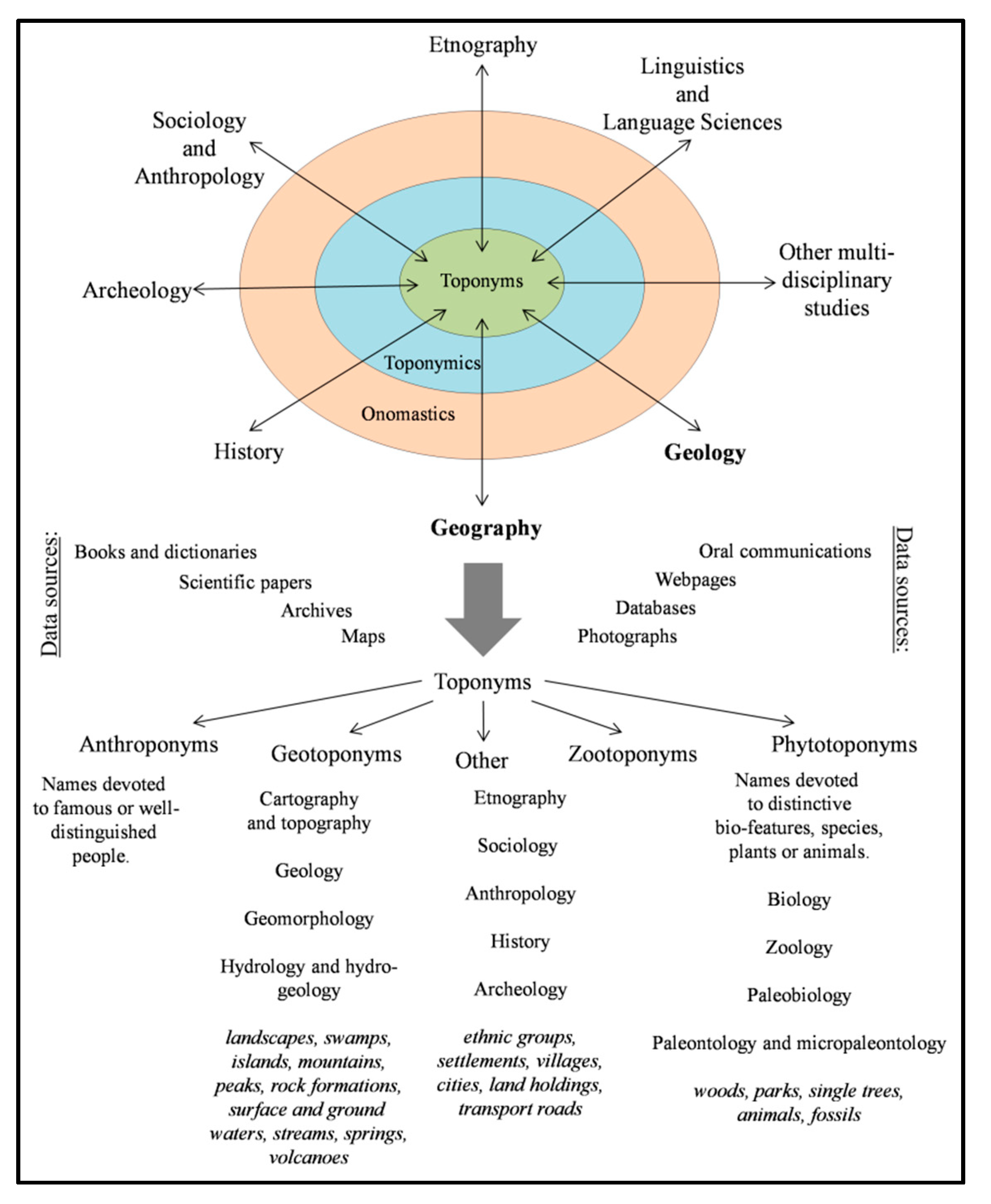
The scientific approach of toponymics (history of places) has developed over recent years, mainly relating to analyses of place names and their etymological meaning [1]. Toponymy, as a part of onomastics, places greater emphasis on natural and humanistic sciences, such as history, anthropology, ethnography, geography, and geology (Figure 1). These constitute the dominant basis for different geographical names, physical objects, natural and public sites (settlements), monuments, and even buildings, and provide access to intricate aspects of history, memories, and places (geoheritage).
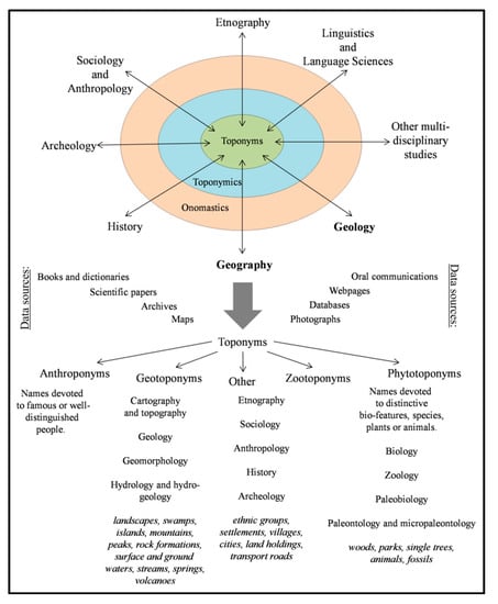
Figure 1.
Interrelations between onomastics, toponymics, toponyms, different group of sciences, and toponymical data sources.
Toponyms include the names for all natural features, such as islands, mountains, hills, lakes, rivers, bays, and other topographies. Cultural or human-made sites usually include cities, towns, villages, parks, fields, roads, and bridges. The general categories or families of place names, such as islands or mountains, are referred to as generic categories. Thus, toponymy provides a kind of historical retrospective view, being a main link to ancestors, ancestral lands, and at the same time the history of peoples, tribes, or nations [2].
Toponymical names express physical and symbolic spaces of objects and identify an authentic sense of place through time, providing a valuable perspective on the past and present of a location at the local level or beyond [3]. Combining the different histories of ideas with the ethnohistory of encounters recontables early modern constructions of a major portion of the globe as more than a linear process of European discovery and naming, especially relating to the so-called “new world” [4]. The naming of Europe-related places took place mostly during ancient, colonial, and post-colonial times, mainly due to military actions, colonization, the presence of dominating tribes or nations, and other causes [5].
Modern toponymic techniques include collection, compilation, and analysis of the following data: web resources, old and recent maps, ancient paintings, pictures or photographs, historical texts, and other accessible materials (Figure 1). The growing use of global online repositories or web archives, which provide scanned and searchable files, considerably increases the application of toponymy.
A number of semantic groups of toponyms has been distinguished: anthroponyms (names, surnames, nicknames of people), geotoponyms (earth-related names: surface forms or groundwaters), phytotoponyms, zootoponyms, and ethnotoponyms (ethnic groups, settlements, land holdings, transport routes). Thus, due to the complex and multifaceted interrelations between toponyms, the toponymics of a described region or place can be an extremely challenging task. Numerous linguistic transformations of names that span historical worldwide epochs have occurred, related to historical, geographical, geopolitical, or sociological factors. In several cases, recognition of the original toponym and proper etymology is difficult. The full analysis of toponymical data allows identification of different historical factors and provides timespan information about changes within the territory [6].
According to the Oxford English dictionary (OED), the term toponymy (or toponomy) denotes the study of place names of a country or district as part of a study [7]. Toponymics is a science relating to features of geographical names and is also related to topography (the science or practice of describing a particular place, city, town, manor, parish, or tract of land). Accurate, detailed delineation or description of any locality or its features is the main task of topology. These approaches are at present related almost exclusively to mathematical sciences (mathematical spaces and objects, mathematical topology, comparison of definitions with recent editions of the OED).
Topology should be considered in a wider historical context as a term meaning “the science of place names tentatively proposed or used in various senses”, or “the science by which, from the consideration of geographical facts about a locality, one can draw deductions as to its history” [7]. The term topology is not synonymous with topography, but bears a similar relation to topography as geology does to geography. Topology may be described as an “art of assisting the memory by associating the thing to be remembered with some place or building, the parts which are well known” [8].
Geographical names or toponyms form an integral part of the linguistic, cultural, and historical heritage of a country, region, or nation. Thus, the study of toponyms relates to origins and meanings of all geographical names and to changes these names have undergone in form, spelling, and pronunciation. A toponymist looks not only at the meaning of a given name but at a wider context, such as the history and spatial–temporal development of specific places or geographic areas. Specific place names represent individual cultures and languages, as these refer to culture, ideas, beliefs, knowledge, and human values. Toponyms are essential cultural footprints and indicators of societal occupation and awareness. The naming of geographical features is often a natural and spontaneous creative process of earth surface identity that provides a means for cultural groups to comprehend and relate to their environment. Hence, the given names define significant spaces of social, economic, and spiritual activity. It is of particular note that several geographical names may have been invented by ordinary people who lived in local communities and evolved due to the normal course of settling, living, and working (as part of the “circle of life”). Usually over time, the given names were accepted and officially established by local laws [2].
2. City of Szczecin as a Target for Toponymics
Szczecin is one of the largest and most important cities in north-western Poland, located about 100 km south of the Baltic Sea, 130 km east of Berlin, and a few kilometers east of the present Polish–German border.
The historical importance and economic growth of Szczecin is related to German influx. The first settlement was initiated in antiquity by Sorb and German tribes that lived in the southern Baltic Sea region. Over time the city developed, especially in the medieval and renaissance periods when it was the Pomeranian duke’s residence, until 1713 (formally 1720), when Szczecin became part of Prussia. During these years, the city was part of the Hanseatic League and an important sea and river harbor [9]. The great industrial expansion of urban areas was started by the Huguenots, who developed crafts and manufacturing. In 1826, the first steam shipping started on the Oder River, and from 1843 to 1846 the first railway connections to Berlin and Poznań were established (Posen, now Wielkopolska, central Poland).
The shipbuilding and steelmaking sectors were gradually expanded [10,11]. Several residential units established factories and infrastructure, which resulted in an increased population from 21,500 in 1816 to 240,000 in 1914. During these years, intensive emigration to the United States, Canada, Brazil, and other countries occurred among the citizens of Szczecin, Western Pomerania, and central Prussia [9,12]. Szczecin was heavily destroyed during World War II and incorporated into Poland in 1945. The city was one of the strongest points of resistance against the Third Reich [9]. At present, the population of Szczecin is about 400,000 citizens [13,14].
One of the nineteenth and twentieth century turning points in Europe was the growth of capitalism. The German Empire (to which Szczecin belonged), among others, started an extensive foreign colonial policy called Weltpolitik, developed and led by chancellor Otto von Bismarck and his successors. Despite some delay in these activities compared to other European countries, the German colonial expansion began in Africa, Oceania, and Asia. With the exploration and conquest of new areas, the first settlements and colonies were established, mainly as suppliers and producers of goods for the German Reich [15].
As important parts of the German Empire, both the city of Szczecin and region of Western Pomerania were involved in the new politics. The colonization processes required land exploration, such as basic geographical, hydrological, and geological processes often carried out by ordinary people, including the first settlers, immigrants, traders, explorers, and natural scientists, who were mentally, familiarly, historically, or politically bound to Western Pomerania and Szczecin. Due to the proximity of Berlin, where science was advanced, significant academic relations between Berlin and Szczecin were formally established.
The short Berlin–Szczecin distance affected the improved research abilities of Szczecin. In 1848–1873, the Deutsche Geologische Gesselschaft (German Geological Society) and Königliche Geologische Landesanstalt und Bergakademie (Royal Geological Institute and Mining Academy) were established [16]. For the early German geognosts, geologists, geographers, and biologists, the journal Zeitschrift der Deutschen Geologischen Gesselschaft (The Journal of German Geological Society), issued in Berlin and devoted to geological issues in Europe and around the world, was an important source of knowledge and scientific information. Geologists and biologists (especially entomologists) associated with Szczecin conducted exploration and research in some exotic places, such as Timor Island (fossils and new fauna description) and other Prussian colonies [17]. Natural scientists from Western Pomerania were among the first explorers to the region, who provided new names.
According to the etymological meaning of Szczecin, the name is probably of Slavic origin. Medieval and post-medieval sources suggest the city name comes from a horse or cow’s “bristles” (szczecina in Polish). An alternative derivation is from the word “sewage” (Polish ścieki), mainly because the Odra river is slowly flowing or "sinking" into the Pomeranian Bay and Baltic Sea [18]. More recent studies assign the name Szczecin to the word “peak” (szczyt in Polish) [19]. This name could also be related to the old German word stette, meaning fortress, or an old German tribe called Sidinians.
Ober the centuries the city name has changed, from “Stetin” (1133), to “Stetyn” (1188), “Stitin” (1251), and also “Stitinum”, “Stetina”, “Stittin”, or “Alten Stettin” [9,20]. The formal Polish name Szczecin was given after World War II (1946).
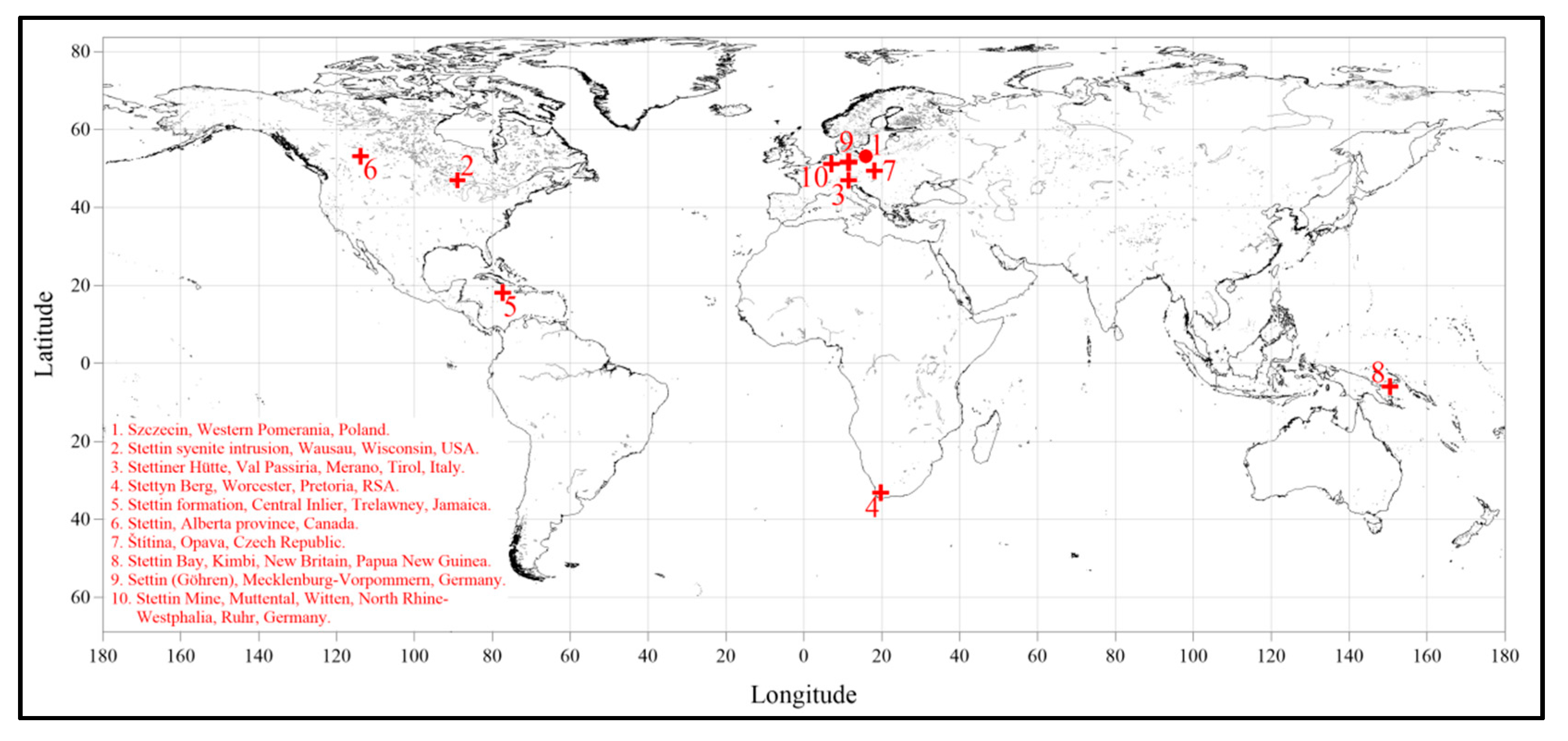
3. Szczecin Locations on the Geographical Map of World
According to analysis of several data sources, webpages, and historical publications, the nine major locations related to the city of Szczecin in terms of name (Stettin, Settin, Stettyn, or Štítina) were identified and described (Table 1, Figure 2). Minor locations such as street and square names shall be the topic of a separate study. These low-scale toponymical relations are found in several cities in Germany, the United States, Canada, and South Africa.

Table 1.
The “Szczecin” related locations described in the text and presented in Figure 2.

Figure 2.
“Szczecin” locations shown on a map of world.
In seven cases, the “Szczecin” name is related to major geological features (structural and lithological units), geomorphological or topographical forms (mountain ranges and peaks, lakes), mining areas, or settlement units. All of the presented locations shall be considered as pathways or signs of migration processes of people from Szczecin, Pomerania, or Western Prussia. The politics and economic issues of colonial expansion led to establishment of the first small settlements and villages, called Stettin or some other variant.
3.1. Szczecin, Western Pomerania, Poland, Europe
The city of Szczecin is geologically located within the Cretaceous, Paleogene-Neogene, and Quaternary chronostratigraphic units. There are no in situ outcrops of pre-Quaternary units, mainly due to a thick complex of glacial and Holocene sediments. The Quaternary is represented by tills, fluvial sands, and organic sediments, mainly peats and gyttja (Figure 3a) [21]. A number of glaciotectonic scales and rafts had been exploited until the 1960s, such as open pit chalk and clay deposits.
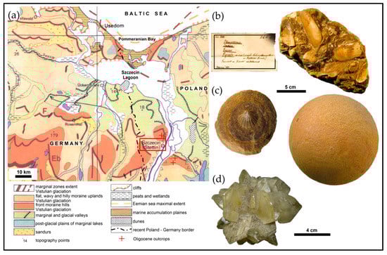
Figure 3.
Location of the city of Szczecin, Western Pomerania, Poland, on the geomorphological map of central Europe (a) [34]. Example of typical mollusk-rich sandstone from “Szczecin sands”, with the old German label and collection of the National Museum in Szczecin (b) (photograph by P. Sztajner, 2010). Pecten stettinensis inside spherical sandstone concretion (Stettiner Kugel) and example of non-crushed specimen (c) (photograph by P. Sztajner, from the collection of the Geological Museum of University of Szczecin, Poland); the length scale is the same for (b) and (c). Representative example of gypsum rosette from Oligocene clays, found in Szczecin (d) (from the collection of B. Cedro and the Geological Museum of University of Szczecin, Poland).
The first geological description of West Pomerania was made by Prussian geologists in the first half of the nineteenth century. Numerous Oligocene outcrops of clays and sands, with septhary and quarzitic-iron concretions that include marine fauna, were identified (Figure 3b). A second type of nodule (Figure 3c) formed spherical shapes with great dimensions, named Stettiner Kugeln (“Szczecin balls” or “bombs”). Additionally, German geologists proposed a new lithostratigraphic subdivision of Oligocene, called Stettiner Sande (“Szczecin sands”) [22,23,24].
The first detailed geological maps and descriptions of Oligocene fossils, including foraminifers, radiolarians, plant macrophytes, as well as molluscs (snails, mussels, scaphopods) and shark teeth, were prepared by Prussian and later Polish geologists [25,26,27]. One of the species was even given a name commemorating Szczecin, namely Pecten stettinensis (Figure 3c) [28,29]. Several specimens can be found in the Geological Museum of the University of Szczecin, Poland [30]. The Szczecin Oligocene clays are also famous for gypsum crystals (Figure 3d) [31,32]. After World War II, Polish geologists Edward Ciuk and Stanisław Dyjor re-named lithological divisions to “Szczecin layers” and stratigraphically classified them as late Eocene/early Oligocene [33].
3.2. Stettin Syenite Intrusion, Stettin Town, Wausau Syenite Complex, Northern Wisconsin, the United States
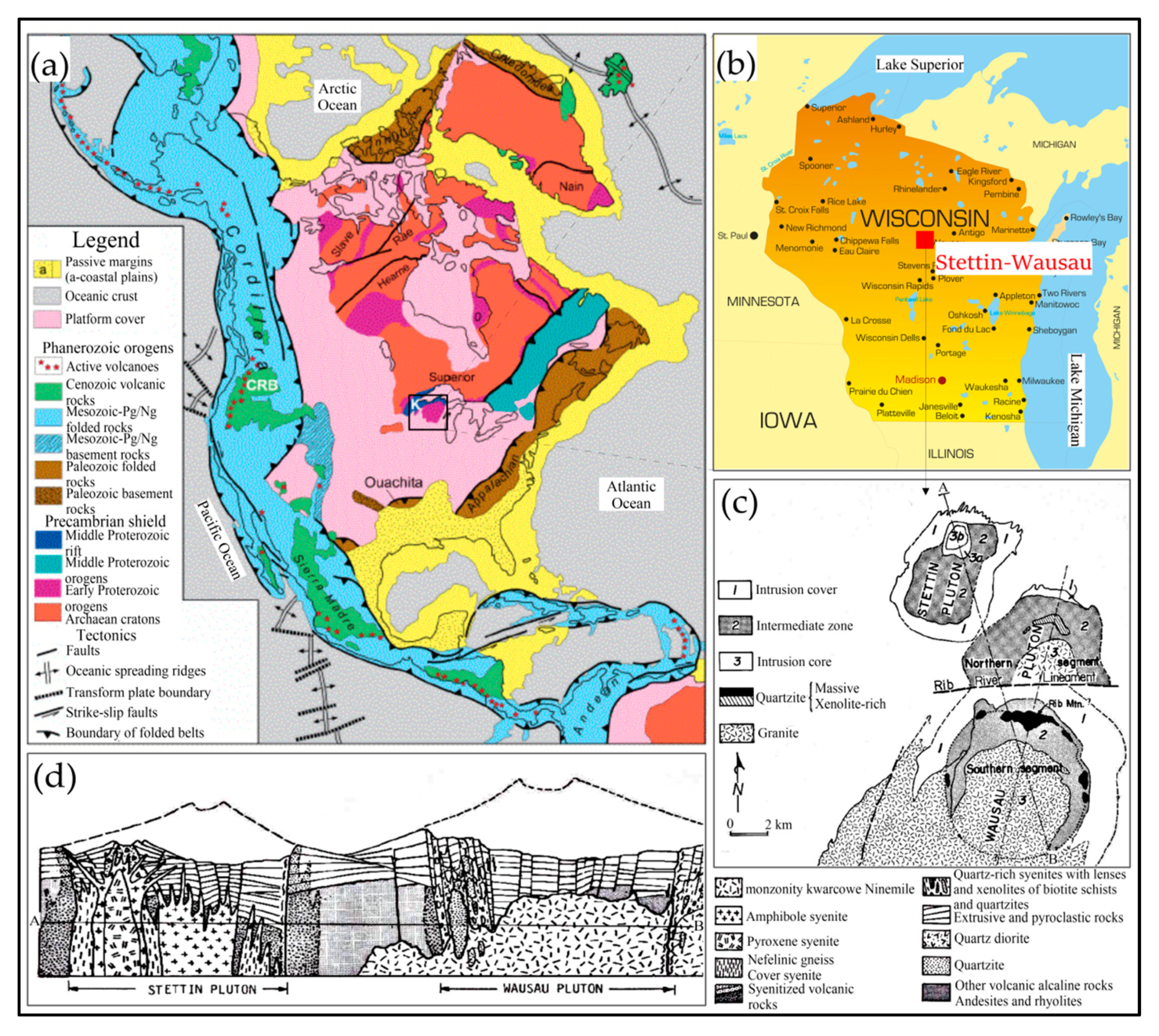
Syenite intrusions of Wausau syenite complex, Northern Wisconsin, the United States, were first described by Samuel Weidman (1907), however detailed information on who proposed this and what circumstances pertain to this name are unknown [35]. Several petrological and mineralogical data are known from the works of Emmons and Snyder (1944), Turner (1948), Geisse (1951), and cartographic works carried out in the 1970s by the Wisconsin Geological and Natural History Survey [36,37,38]. More recent geological data include works by Koellner (1974), LaBerg and Myers (1983), and Myers et al. (1984) [39,40,41].
The Wausau complex is part of the NW–SE-oriented belt of anorogenic granitic-type Precambrian intrusions with ages of 1.77 to 1.03 billion years (Ba) (Figure 4a,b). Granite rocks are mainly rapakiwi-type. The Wausau syenite complex was exposed during the last glacial retreat. Neighbouring crystalline rocks of Precambrian shield are composed of Archaic metamorphic migmatites, gneisses, and shale, dated to more than 2.80 Ba, accompanied by quartz-sillimanite, biotite schists, and metavolcanic rocks of amphibolite facies (gneisses, gabbro, tonalite, trondheimites, basal quartzites, and metasediments). The archaic Proterozoic complex is partially covered and cut with several intrusions of younger volcanic rocks, tonalites, trondheimites, and granodiorites, which include calcium-alkaline-rich basalt-rhyolite metamorphosed in younger Proterozoic greenschists. The younger Proterozoic complex is unconformably overlain by rhyolites, pyroclastic rocks, and intrusions with A-type granites of an approximate age of 1.76 Ba. Both complexes were dislocated tectonically during 1.63 to 1.60 Ba along the Stevens Point–Neillsville-oriented E–W fault system (Figure 4c).
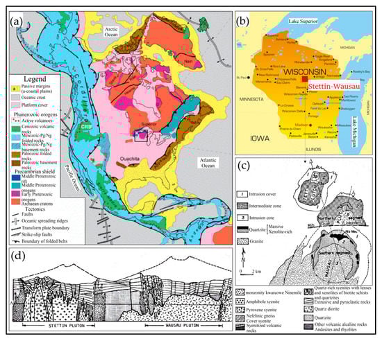
Figure 4.
Location of Stettin syenite intrusion within the Wausau syenite complex (a) and Wisconsin state (b) [42,43]. The geological plan (c) and cross-section (d) from [40,44].
The Stettin syenite intrusion shows a mean age of 1.52 Ba and is the oldest and most alkaline intrusion in the Wausau complex. The intrusion forms a large batholith with a well-developed nepheline core, visible in the terrain as a hill covered with thick forest. According to Emmons and Snyder [36], the formation of the Stettin intrusion is due to metamorphosis of feldspar-rich rocks along the shear zones and contact with the alkaline-rich hydrothermal solutions derived from other surrounding granitic intrusions. The Stettin syenite intrusion shows a concentric form and elongated NE axis direction in plan view. The dimensions are small at 8 km long and 6 km wide (Figure 4c,d), with the major rocks being of four types of syenite, which developed in contact with laminated metasediments and thermally altered volcanic rocks. All lithotypes have diverse and often gneiss to pegmatitic textures.
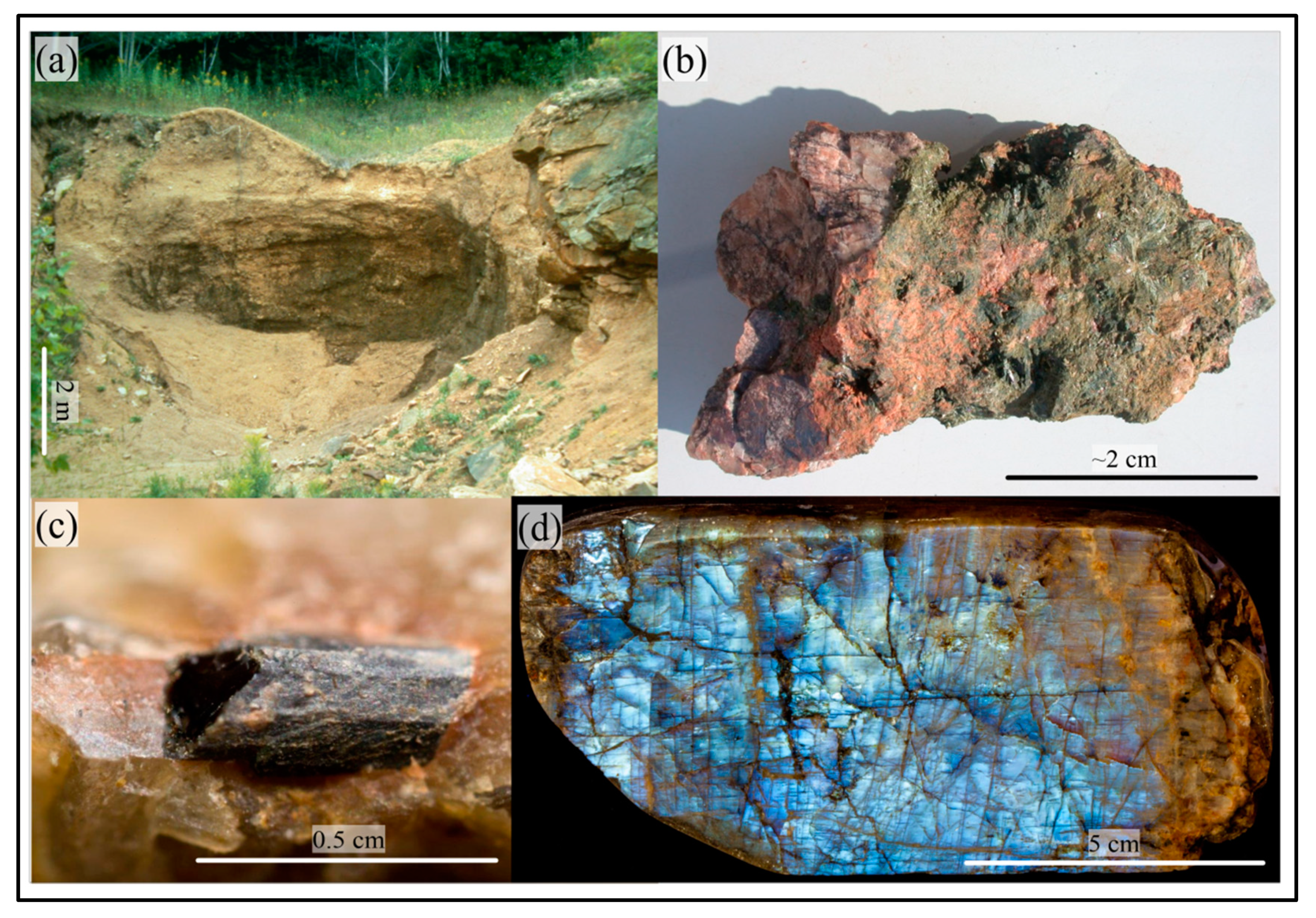
Several mineral specimens [45,46,47] found in small outcrops (Figure 5a) contain REE-rich (Rare Earth Elements) and rare minerals, such as hastingite, Hf-zircon, elpidite, and Ce-rhabdophane (Figure 5b,c). Large pertitic-feldspars over 35 cm in length have been found and described as forming with amphiboles and pyroxenes, forming so-called “moonstone” (Figure 5d). The most interesting specimens occur in the contact zones and within pegmatite bodies. The central part of the Stettin intrusion is composed mainly of larvikite, with agpaite-rich occurrences that indicate the presence of carbonatite-type rocks rich in magnetite. The full list of minerals from the Stettin pluton amounts to more than 60 [48].
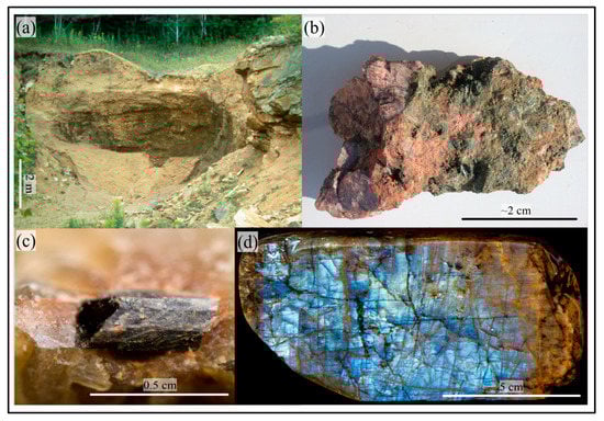
Figure 5.
Mineral specimens from the Stettin intrusion: example of a local geological outcrop, the so-called Zunker’s Pit (a) [48]; green aegirine with red orthoclase (b) [49]; small Ce-chevkinite crystal in a matrix (c) [49]; anorthoclase “Wisconsin moonstone” (d) [50].
Stettin was established by the settlement of lumberjacks and farmers of Prussian descent who also founded Berlin circa 1834–1835. The area was previously known to fur traders. Further development of the Stettin settlement was associated with founding of a sawmill (1844) and the first farm (1856). Initially, 75% of the population was of Prussian descent. Several early settlers came directly from Pomerania and proposed names for the location according to their homeland. Other settlers were Norwegian and Irish immigrants [51].
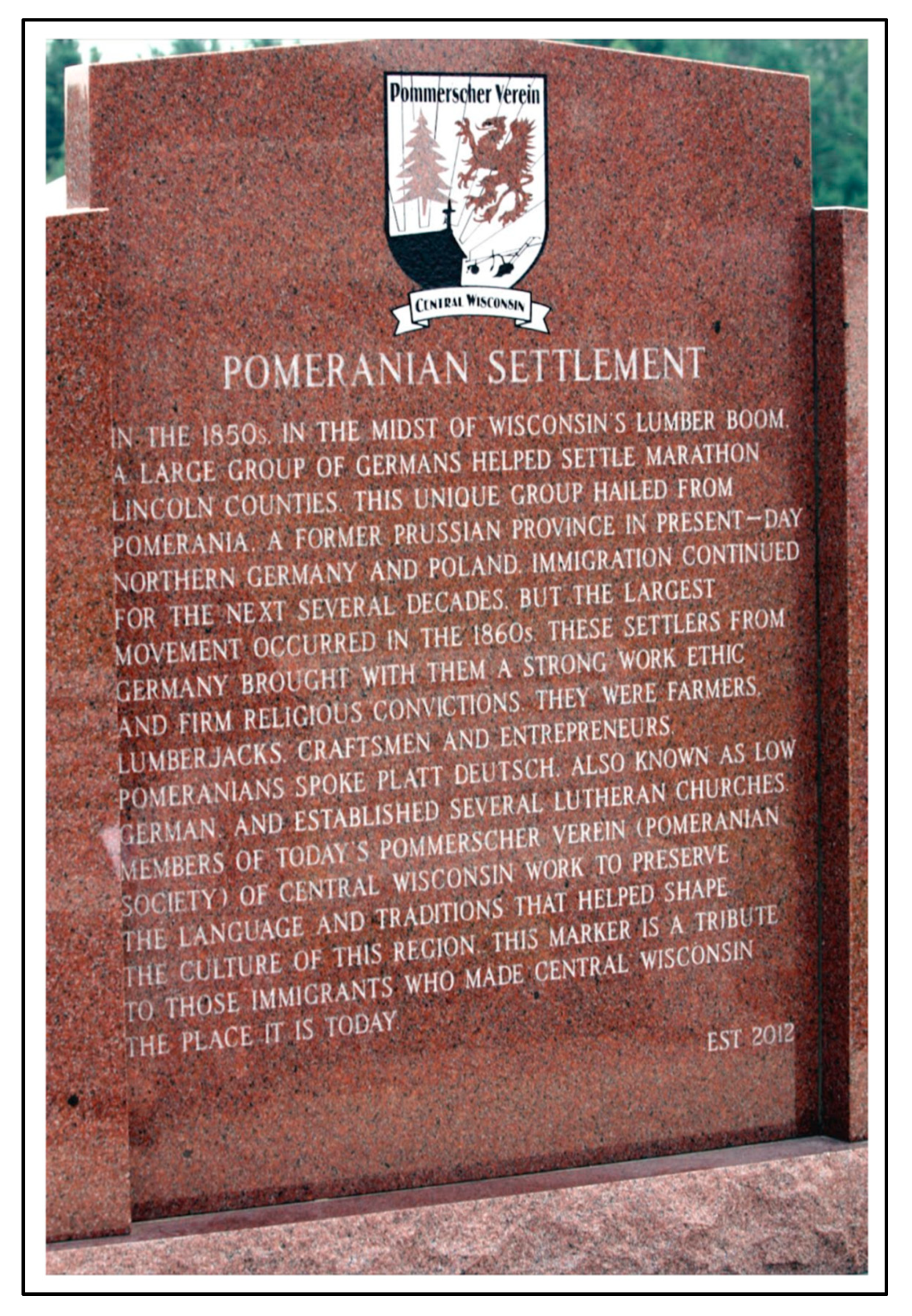
The largest group of immigrants arrived in the 1860s and the Stettin settlement was formally transformed into a city in 1860. The immigrants helped to establish many nearby vicinities, also named after German locations. Today, as a kind of a memorial, a monument exists in Berlin made from local red granite (Figure 6) [52].
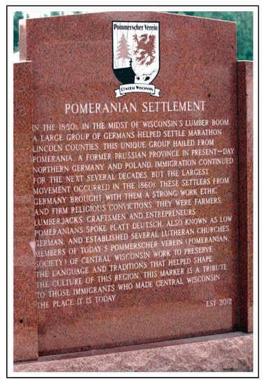
Figure 6.
The Pomeranian settlers memorial made from regional red granite, located in Berlin town, Wisconsin, the United States [52]. The griffin figure is the same as the historical Pomeranian griffin of Western Pomerania, Voivodship, Poland. The head of the griffin is also part of the official coat of arms in Szczecin, Poland.
Prior to colonization by Europeans, the area described was considered inaccessible because of native tribes. However, the location was extremely attractive as a settlement location due to resources such as wood and fur. The retreating Pleistocene continental glaciation left significant amounts of raw materials, mostly sands and gravels. Detailed geological exploration revealed several igneous intrusions that spread across Wisconsin. The local industry continues to be based mainly on raw mineral resources.
3.3. Stettiner Hütte, Val Passiria, Merano, Tirol, Italy
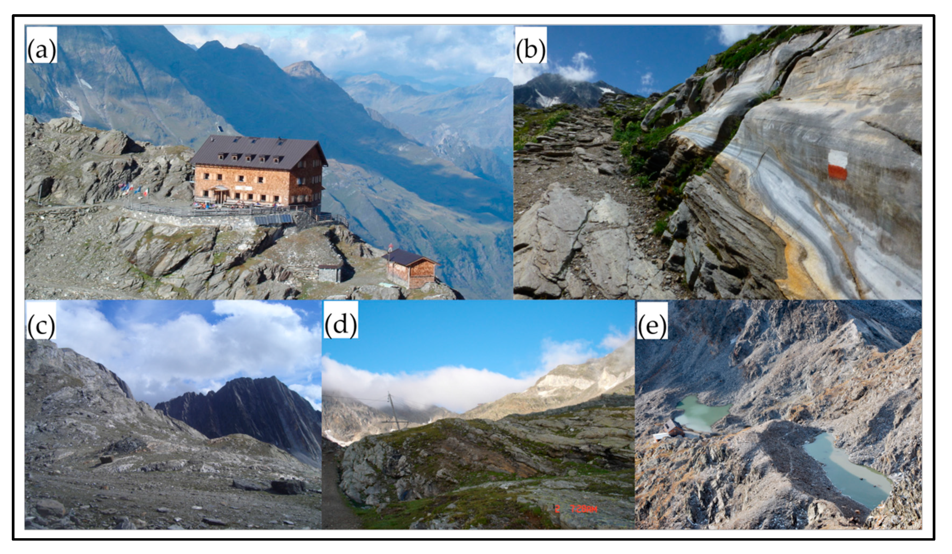
The Stettiner Hütte or “Szczecin’s Hut” is an attractive alpine mountain hostel (Figure 7a), placed at an altitude of 2875 m, near the Eisjöchls (2895 m), Höhe Weise (3279 m), and Höhe Wilde (3480 m) peaks, located in the vicinity of Merano town, central East Alp region, Tirol, Italy. The Stettiner Hütte is part of a network of thirteen shelters in Parco Naturale Gruppo di Tessa. The first hut shelter was erected between 1900 and 1913. In 1922, the Stettiner Hütte was taken over by a group of Italian mountain climbers from Padua’s Club Alpino Italiano (CAI). In the years since, the shelter has been under Italian control, surviving numerous avalanches and snowstorms. Recently, the road to the hut was adapted for mountain biking [53].

Figure 7.
The Stettiner Hütte and Alpine landscapes, with the elevated Eisjöchls peak in the background (a) [54]. The outcrops of metamorphic schist along the route to Zwickauer Hütte (b) [55]. The view of steep limestone layers along the route to the Stettiner Hütte (c,d) [56]. Small mountain glacial lakes located near Stettiner Hütte (e) [54].
The modern location dates back to 1895–1897, when a group of mountain climbers from Deutschen und Österreichischen Alpenverein (German-Austrian Alpine Society) in Stettin cleared the first trail to this mountain range crossing above the Pfelder valley [54]. This route and mountain hut serve as testimony to this titanic work, which made this part of the Alps available for mountaineering. The mountain climbers from Szczecin also made several geological and geomorphological observations of metamorphic mica schists (Figure 7b), limestones (Figure 7c,d), and karst phenomena. They observed small mountain lakes (Figure 7e), peaks with developed colluvium rockslides, and almost vertical rock layering, especially on the way to the Hochganghaus peak (1839 m a.s.l.) and Zwickauer Hütte.
3.4. Stettyn Berg (Peak) and Stettin Village, Worcester, Pretoria, Republic of South Africa
The “Stettyn”, located in South Africa about 100 km NE of Cape Town, is a small settlement in Western Cape province (West Cape) situated at an altitude of 320–330 m (Figure 8a). The history of the region and the Stettyn settlement is associated with 18th century immigration from Europe. Several areas around Stettyn are known for wine production (Figure 8b). In 1714, Governor Chavonnes from the Eastern Netherlands Indian Campaign planted a farm for two families of settlers from Prussian Szczecin (surnames Cloete and Radyn). An inflow of immigrants to Stettyn began in 1777. Since 1818, Stettyn has been the property of the Botha family. In the middle of the 20th century, many new wineries were opened [57].
The Stettyn (Stettynberg) name applies to a mountain range located in Western Cape province, which is structurally part of the Cape Fold Belt system. The mountain range resulted from the collision of African and South American tectonic plates during the Pangea accretion. The mountains exhibit a folded character and have advanced fault tectonics. The intensified erosion processes, dating from 0.2 Ba, led to the creation of several deep valleys, partially filled with fluvial sediments. The peaks are built of resistant sandstones and quartzites that form the Table Mountain (Tafelberg) and Witterberg ranges (Figure 8c). The bottom sections of river valleys usually contain eroded shales and mudstones of the Bokkeveld group. In some cases, clastic veins and pyroclastic material admixtures are found, which are often clearly visible [58]. The soils developed on these rocks are usually useful and adaptable for vineyards. The culmination of the Stettynberg area is Stettyn peak, one of the highest and southern-most locations in Africa (Figure 8d).
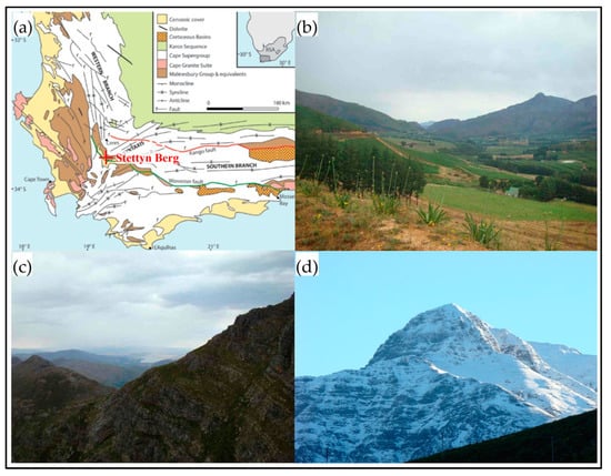
Figure 8.
Location of Stettyn, Stettynberg, and Stettyn Peak within the Cape Fold Belt, Table Mountain group, South Africa (a) [59]: Stettyn village and surrounding steep hills covered by several vineyards (b); steep sides and layering of Table Mountain sandstones and quartzite (c); view of one of the highest peaks in South Africa and the southern-most peak in Africa, Stettyn Peak (~1821 m a.s.l.) (d). All photographs from [60].

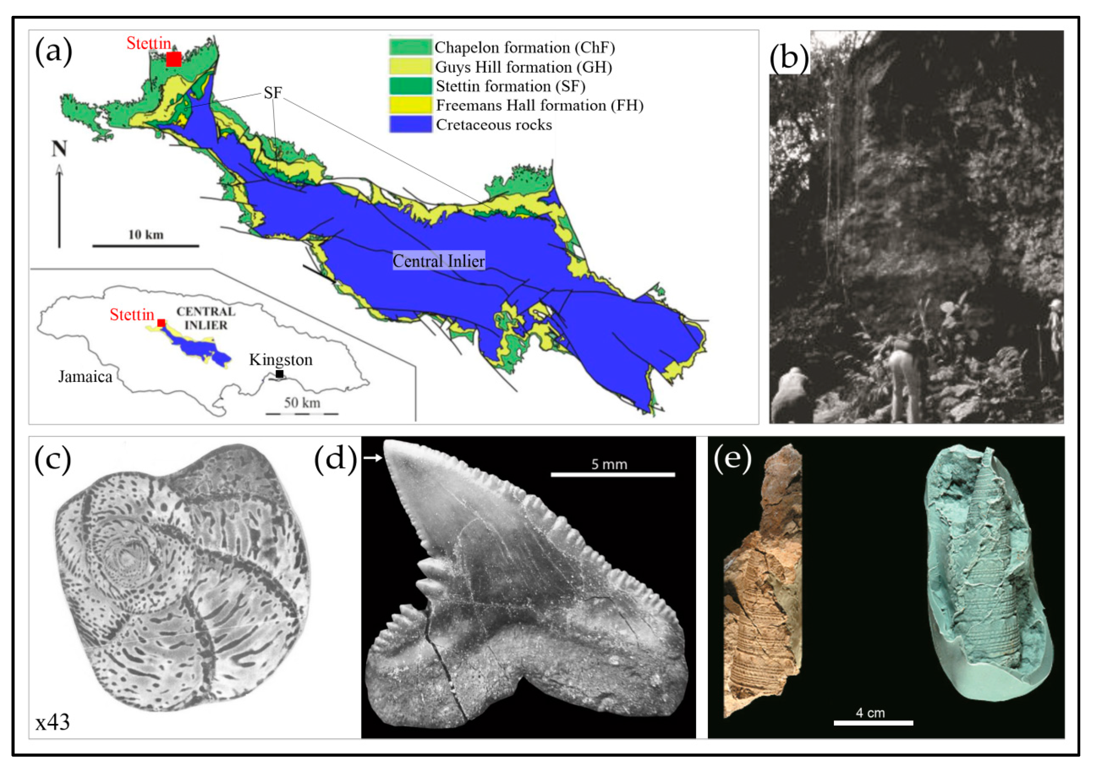
3.5. Stettin Formation and Stettin Town, Central Inlier, Trelawney County, Jamaica
The name Szczecin is represented in the geography and geology of Jamaica. “Stettin” is a small town situated in the island’s central part, with several geological outcrops of marine rocks, known in the geologic literature as “Stettin formation”, being the subgroup of the Chapelon formation (Figure 9a). The “Stettin formation” contains various types of transgressive, shallow-marine organogenic yellow limestones and minor sandstones, dating from the middle Eocene (Luthetian) and with a total thickness of up to 150 meters. The rocks of the Stettin formation show distinctive karst processes, which are visible in the terrain as numerous linearly directed depressions and elevations, funnels, and sinkholes, which are typical of the central part of Jamaica (Figure 9b). Rocks of the Stettin formation are rich in fossils of molluscs and vertebrates [61]. A wide range of foraminifera was also recognized and described (Figure 9c–e) [62]. The Stettin formation composes a carbonate platform, which is the main evidence of the first Palaeogene maritime transgression in Jamaica [63].
The Stettin township, located in Trelawney county, was one of the first German colonial settlements on the island, established by Dr. William Lemonius who came from Western Pomerania in about 1834. His family was originally from Szczecin. Lemonius was a renowned officer of the Prussian army and took part in the failed European uprising against Napoleon Bonaparte. After the uprising failure, he was saved by the British Royal Navy and became a Prussian officer of the army of Prince von Brunswick. He organized the transport of Prussian immigrants from Bremen to Jamaica [64], who similar to Lemonius, came mainly from northern Prussia. The Europeans were mostly of the Catholic faith and founded the first settlements in this part of the island. Lemonius arrived on the island among the first one thousand German settlers, who came mainly as planters, often accompanied by their families. Many of them died of tropical diseases, and many later migrated to the United States. It needs to be mentioned that the economic development of Jamaica was dominated by the immigration of Spanish and British colonists [65]. At present, the area of Stettin Town is mainly a farming zone and is not especially attractive as a tourist destination.

Figure 9.
Location of Stettin town and Stettin formation (SF) within Central Inlier, Jamaica (a) [66]: old photograph showing cliff outcrop of SF carbonate rocks overhanging the exit of Wait-a-Bit Cave (b) [61]; typical foraminifer Fabularia verseyi from local limestones (c) [63]; Carcharhinus shark tooth (d) [66]; the gastropod Campanile trevorjacksoni (e) [67].
3.6. Stettin Settlement, Alberta Province, Canada
The Stettin settlement, located in the central part of Alberta province, Canada (for location see Figure 2), about 15 km NW from Edmonton, is a village founded most probably at the beginning of the twentieth century by Herman Libke (1913), who originated from Pomerania, Germany, as the first postman in the region [68].
No important historical data on the detailed geological exploration is presently available. The nearby area is a flat part of the Alberta plain that is extensively modelled by continental Pleistocene glaciations, with numerous small post-glacial lakes. The plain area is composed of sedimentary Upper Cretaceous and Paleogene/Neogene rocks of the Wapipi formation. Several small deposits of raw materials are located here (sands, gravels, and minor clays). Local immigrants were mainly Presbyterians who came there due to the activities of the German–American Colonization Company, who sought wood, furs, and employment as railway construction workers [69].
3.7. Štítina Community and Village, Opava County, Czech Republic
Štítina, located in the Silesian-Moravian region, Czech Republic, is a small community and village (for location see Figure 2) with a known history that dates to the thirteenth century. In a few historical sources, the name “Stettin” occurs, but there is no further evidence of a toponymical relation with Szczecin, Poland [70].
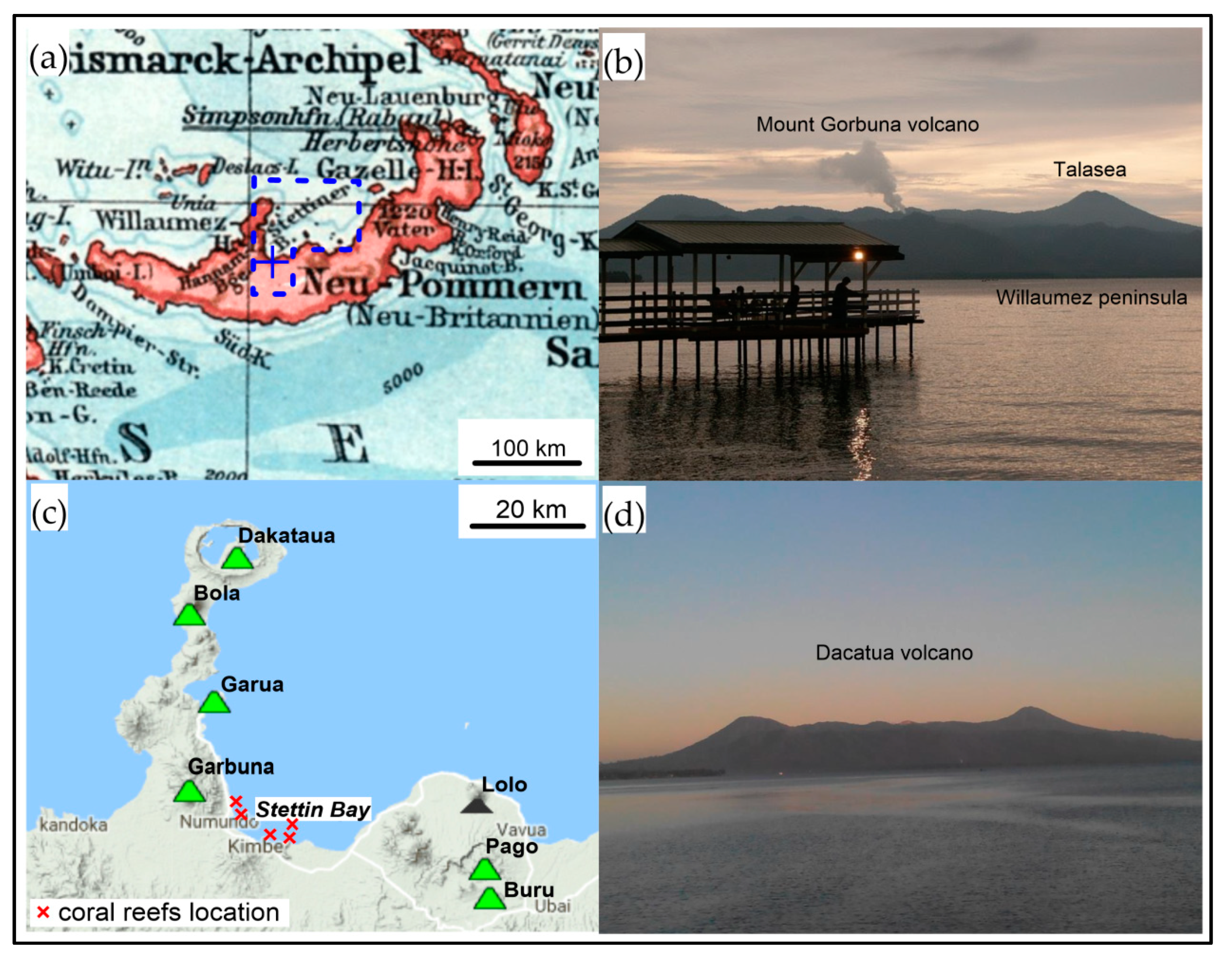
3.8. Stettin Bay, Kimbi Region, Western New Britain, Papua New Guinea
Stettin Bay, located in New Britain, Papua New Guinea, Bismarck Archipelago, near the city of Kimbe, is a shallow marine bay with several coral reefs that disrupt local navigation (Figure 10a,c). Coral reefs are exposed during low water stands. The nearby beaches are sandy, with a large admixture of black volcanic material [71]. The whole area is currently a nature protection site due to the significant logging of tropical forests and cultivation of oil palms [72].
New Britain island is the largest in the Bismarck Archipelago. In 1884, this became a protectorate of Prussia, and Neu-Pommern (New Pomerania) and Neu-Mecklenburg (New Mecklenburg) provinces were established. The first settlers sought wood and subordinated the native tribes for the purposes of slavery. Soon, several coconut, cotton, gum, and coffee plantations were built, but the colonists were afraid to go deeper into the island. The area was little explored until the early twentieth century. The first scientific exploration was carried out in 1908 by German geologists from the Hambyryan Scientific Society [73], who examined rock samples, soils, and the Garui geysers, although no direct information is available of the sources.
New Britain has many active volcanoes (Figure 10b,d). The area surrounding “Stettin Bay” is volcanically active, with several Quaternary volcanoes on which fertile soils and wetlands were formed. The six major active volcanoes are Garbuna, Garua, Boa, Dakataua, Pago, and Buru, along with one inactive volcano (Lolo). Volcanic phenomena are visible, especially hot springs, fumaroles, and geysers. The magma is rhyolitic, andesitic, and basaltic. Stratovolcano-type volcanoes produce ash (dacite pumice, volcanic glaze, and bombs), and in some cases, produce Plinian eruptions. The last intensive volcanic activity of Pago took place about 1200 years ago, while Garbuna erupted in 2005 after more than 1800 years of silence [74]. The volcanic cones presently show intensive erosion and poor vegetation processes.
German expeditions and related exploration and scientific research in the Pacific were strongly influenced by growing colonial interest and ethnology (Völkerkunde), which began in the late nineteenth century. The colonial expansion initiated interest among German naturalists and scientists. The nature research was seen as an important contribution to promote and help Germany’s economic and political growth. Natural scientific and ethnological research within the colonies were strongly supported and encouraged by the German Empire [75].
It is worth mentioning that German settlers also established Mount Varzin (Warcino) near Stettin Bay. The name was taken from the Varzin village, at present Warcino in Poland, located between Western Pomerania and Pomerania regions. The Varzin village was a noble property of the Bismarck family [76].
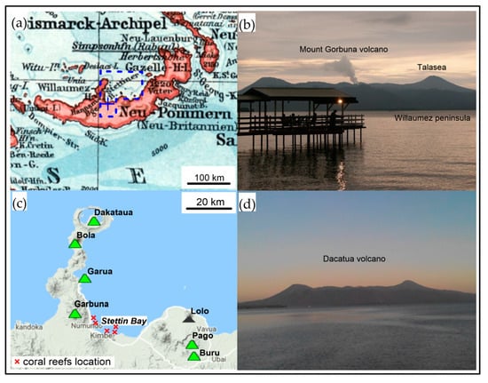
Figure 10.
Location of Stettin Bay at Neu-Pommern, Bismarck Archipelago (at present New Britain) (a) [73]. View from Stettin Bay to the active Mount Gorbuna volcano and Willaumez peninsula (b) [77]. Volcanoes and coral reefs in the area of Stettin Bay (c) [71]. View from Stettin Bay to the largest active volcano, Dakataua (d) [78].
3.9. Settin (Göhren), Mecklenburg-Vorpommern, Germany
Settin (or Göhren) is a small settlement founded in 1485, which initially had only a few buildings, located along the E–W road between Hamburg (Germany) and Szczecin, being historically one of the most important Hanseatic land trade routes (see Figure 2). At the beginning of the twentieth century, the Settin settlement was incorporated into the village of Göhren [79].
The exact history of the vicinity and name acquisition is unknown but is probably connected with a Pomeranian tradesman settlement. Also in the vicinity is a small post-glacial lake (Settiner See), which is typical of this region. Another slightly larger lake (Stettiner See, 13 ha) is situated a few km north towards Schwerin city, also of post-glacial genesis, and which is a part of Schweriner Seenlandschaft (Schwerin Lake Landscape Park) [80]. The surrounding area serves as a tourist destination with few non-exploited deposits of raw materials.
3.10. Stettin Mine (Shaft), Muttental, Witten, North Rhine-Westphalia, Ruhr, Germany
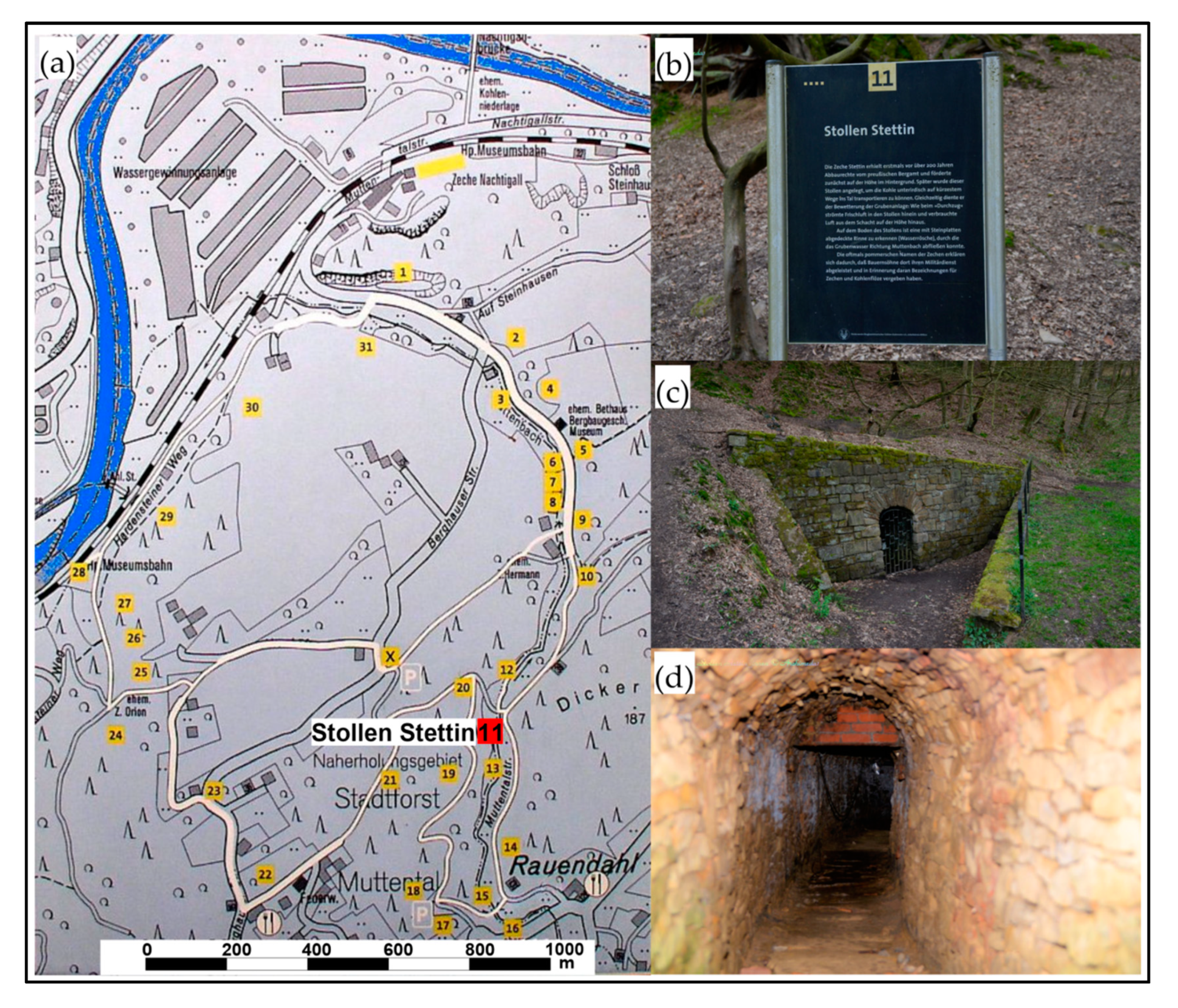
The Stettin mine, located in Witten-Muttental, historically known as the Neuglück and Stettin mine or Zeche Stettin and Neuglück, is an old black coal mine that is part of the Geopark of the Ruhr Basin (Bergbauwanderweg Muttental) (Figure 11a–d).
The mine’s history starts in 1758 as Zeche Neuglück, established by a group of Pomeranian explorers and mining engineers who worked for the Prussian army (Johann Caspar Dürholt, Johann Peter Kickut, and Peter Caspar Hilby) [81,82]. Construction of the main shaft started after several years of deposit prospection and preparatory work [83] and continued, with some stoppages, until 1796. It was reopened in 1824 under the new name Zeche Neuglück and Stettin, which was later changed to Zeche Herberholz. The main coal resources were already strongly depleted and prospection of deeper deposits was done. In 1934, the mine was shut down again and the shafts were filled with water. After World War II, the mine, called Zeche Neuglück II, was exploited for a few years with significant amounts of bituminous coal recovered, measuring hundreds of tons per year in poor periods and up to 3000 tons per year in the best ones [81].
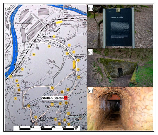
Figure 11.
Location of Stettin Mine and Stettin Shaft in Muttental, Germany (a): information next to Stollen Stettin (b) [84]; temporarily closed entrance (c) and typical old coal shaft built from bricks (d) [85].
Figure 11.
Location of Stettin Mine and Stettin Shaft in Muttental, Germany (a): information next to Stollen Stettin (b) [84]; temporarily closed entrance (c) and typical old coal shaft built from bricks (d) [85].
4. Conclusions and Relations to Practical Toponymics
Topological exemplification of the city of Szczecin, the largest and most important city in north-western Poland and the historical and most recent capital of Western Pomerania, provides valuable insight into the tracking history of geographical names and their global spreading patterns.
The historical significance and growth of Szczecin is strongly related to Prussian influx and geopolitics, especially related to the German Empire. This development of the southern Baltic Sea area and Pomerania was initiated in antiquity by the first Sorb and German tribes. With historical turbulence, Szczecin developed in the medieval period and renaissance era, mostly influenced by the activities of Pomeranian dukes, until 1713 (formally 1720) when it was included into the borders of Prussia. The role of Szczecin as an important Hanseatic sea and river harbor increased during these years. The great expansion of industry in the nineteenth century induced a large influx of people from other parts of Pomerania and Wielkopolska (central Prussia), at the same time Europe began an extensive colonial policy abroad led by chancellor Otto von Bismarck and his successors. The extensive colonial expansion began in Africa, Oceania, and Asia.
The first settlers, travelers, immigrants, and geoscientists, being mentally, familiarly, and historically bound to Szczecin and Pomerania, established several colonies and villages around the world. The exploration of new places also led to the naming of certain geographical and geological units, such as rock formations, mountain peaks, lakes, bays, and in some cases even mines, shelters, and paleontological species. The major toponymical units, particularly cities or villages, were established by economic or political migration of citizens. Naming of smaller units was related to single explorers or small groups of highly specialized settlers. These new places became part of a globally shared geoheritage.
Especially worth mentioning is the use of modern toponymic techniques related to the analysis of great amounts of data provided in global databases, which include scans of old documents, maps, paintings, and other easily accessible web materials. Most recent research papers on toponymics deal only with the strictly linguistic etymology (or derivation) of different location names. The new techniques may be used not only to explain the names’ linguistic history (onomastics), but also to trace spreading patterns of toponyms. The growing use of global online repositories or web archives containing scanned and searchable files considerably increases the application abilities of toponymics. Unfortunately, providing precise details of the “who, how, and why” of different names is a time consuming and expensive job, requiring the querying of old and non-digitized archives or genealogical research.
Funding
Publication of the article was funded by Institute of Marine and Coastal Sciences, University of Szczecin, Poland.
Acknowledgments
I wish to thank Sylwia Zawadzka, for the linguistic assistance and correction of the manuscript. I’m grateful to Andrzej Osadczuk (University of Szczecin) for the technical and financial support and Kevin McCartney (University of Maine at Presque Isle) for valuable comments and help during the review process. Finally, I would like to thank anonymous reviewers for constructive comments on the manuscript.
Conflicts of Interest
The author declares no conflict of interest. The funders had no role in the design of the study; in the collection, analyses, or interpretation of data; in the writing of the manuscript, or in the decision to publish the results.
References
- The Cambridge Dictionary. Available online: https://dictionary.cambridge.org (accessed on 10 June 2018).
- Handcock, W.G. An Introduction to Geographical Names and the Newfoundland and Labrador Geographical Names Board. NLGNB Rep. 2010. Available online: https://www.gov.nl.ca/landuseatlas/documents/1%20-%20An%20Introduction%20to%20Geographical%20Names%20and%20the%20NLGNB.pdf (accessed on 21 July 2019).
- Fuchs, S. History and heritage of two Midwestern towns: A toponymic-material approach. J. Hist. Geogr. 2015, 48, 11–25. [Google Scholar] [CrossRef]
- Douglas, B. Naming places: Voyagers, toponyms, and local presence in the fifth part of the world, 1500−1700. J. Hist. Geogr. 2014, 45, 12–24. [Google Scholar] [CrossRef]
- Kadmon, N. Toponymy and Geopolitics: The Political Use- and Misuse- of Geographical Names. Cartogr. J. 2004, 41/2, 85–87. [Google Scholar] [CrossRef]
- Tsinkoburova, M. Geology at the service of historical geography: About some controversial cases of the etymology of toponyms in the central part of the Lake District of Russia. In Proceedings of the 19th International Multidisciplinary Scientific Conference (SGEM 2019), Albena, Bulgaria, 27 June–6 July 2019. Issue 19/1. [Google Scholar]
- The Oxford English Dictionary. Available online: https://www.oed.com (accessed on 12 June 2018).
- Murray, J.K.H. (Ed.) The Oxford English Dictionary; Oxford University Press: Oxford, UK, 1933; Volume 11, p. 154. [Google Scholar]
- Białecki, T. (Ed.) The Encyclopedia of Szczecin, 2nd ed.; Szczecińskie Towarzystwo Kultury: Szczecin, Poland, 2015; pp. 909–1016. [Google Scholar]
- Włodarczyk, E. Rozwój Gospodarczy Miast Portowych Pruskich Prowincji Nadbałtyckich w Latach 1808−1914; Zakład Narodowy im. Ossolińskich: Wrocław, Poland, 1987. [Google Scholar]
- Włodarczyk, E. The Evolution of the Maritime Function of the 19th Century Pomeranian Port Towns. Studia Maritima 2011, 24, 147–159. [Google Scholar]
- Stanielewicz, J. City of Szczecin and American Commercial Connections in the First Half of the 19th Century. 2010, 60, pp. 366–376. Available online: http://bazhum.muzhp.pl/media//files/Ekonomiczne_Problemy_Uslug/Ekonomiczne_Problemy_Uslug-r2010-t-n60/Ekonomiczne_Problemy_Uslug-r2010-t-n60-s366-376/Ekonomiczne_Problemy_Uslug-r2010-t-n60-s366-376.pdf (accessed on 19 January 2020).
- Piskorski, J.M.; Wachowiak, B.; Włodarczyk, E. A Short History of Szczecin; Poznańskie Towarzystwo Przyjaciół Nauk: Poznań, Poland, 2002. [Google Scholar]
- Chojecki, D.K.; Giza, A.; Włodarczyk, E. Atlas Gmin Pomorza Zachodniego w 1939 Roku, Demografia–Społeczeństwo−Gospodarka; Wydawnictwo Naukowe Uniwersytetu Szczecińskiego: Szczecin, Poland, 2017. [Google Scholar]
- Zimmerman, A. Race and World Politics: Germany in the Age of Imperialism, 1878−1914. In The Oxford Handbook of Modern German History; Smith, H.W., Ed.; Oxford University Press: Oxford, UK, 2011; pp. 359–377. [Google Scholar]
- Burke, P. A Social History of Knowledge II: From the Encyclopaedia to Wikipedia; Polity Press: Cambridge, UK, 2012; Volume 2, p. 164. [Google Scholar]
- Beyrich, E. Über eine Kohlenkalk-Fauna von Timor; Druckerei der Königl. Akad. der Wiss: Berlin, Germany, 1865; pp. 1–98. [Google Scholar]
- Kwaśniewicz, W. 1000 Słów o Broni Białej i Uzbrojeniu Ochronnym; Wydawnictwo Ministerstwa Obrony Narodowej: Warszawa, Poland, 1989; pp. 323–336. [Google Scholar]
- Rospond, S. Słownik Etymologiczny Miast i Gmin PRL; Zakład Narodowy im. Ossolińskich: Wrocław, Poland, 1984; pp. 380–381. [Google Scholar]
- Grucza, F. Nazwy miejscowe i wodne Szczecina oraz najbliższej okolicy. In Dzieje Szczecina–Pradzieje Szczecina; Filipowiak, W., Labuda, G., Eds.; Wydawnictwo Naukowe PWN: Poznań, Poland, 1983; Volume 1, pp. 15–16. [Google Scholar]
- Borówka, R.K. Budowa geologiczna i rozwój rzeźby Pomorza Zachodniego. In Środowisko Przyrodnicze Wybrzeży Zatoki Pomorskiej i Zalewu Szczecińskiego; Borówka, R.K., Musielak, S., Eds.; Oficyna In Plus: Szczecin, Poland; pp. 5–18.
- Behm, J. Tertiärformation von Stettin. Z. Dtsch. Geol. Ges. 1857, 9, 323–354. [Google Scholar]
- Beyrich, E. Über die Abgrenzung der oligozänen Tertiärzeit. Monatsberichte K. Preußischen Akad. Wiss. Berl. 1859, 11, 51–69. Available online: https://www.biodiversitylibrary.org/item/41578 (accessed on 19 January 2020).
- Deecke, W. Geologie von Pommern; Gebrüder Borntraeger: Berlin, Germany, 1907. [Google Scholar]
- Odrzywolska−Bieńkowa, E. Utwory trzeciorzędowe z otworu Szczecin IG I w świetle badań mikropaleontologicznych. Kwart. Geol. 1967, 11, 118–130. [Google Scholar]
- Jakubowski, G. Fauna oligoceńska okolic Szczecina. Prz. Geol. 1983, 31, 428–430. [Google Scholar]
- Cedro, B.; Sztajner, P. Skamieniałości oligoceńskie Pomorza Zachodniego. In Środowisko Przyrodnicze Wybrzeży Zatoki Pomorskiej i Zalewu Szczecińskiego; Borówka, R.K., Musielak, S., Eds.; Oficyna In Press: Szczecin, Poland, 2005; pp. 34–37. [Google Scholar]
- Von Koenen, A. Das marine Mittel-Oligocän Norddeutschlands und seine Mollusken-Fauna. Paleontographica 1868, 16, 53–128. [Google Scholar]
- Reich, M. “Pecten” stettinensis v. Koenen, 1868 (Mollusca: Bivalvia) from the “Stettin rock” (Oligocene). Geschiebekd. Aktuell 2002, 18, 1–2. [Google Scholar]
- Zawadzki, D. The most valuable scientific collection at the Geological Museum of Szczecin University. Opuscula Musealia 2017, 25, 135–145. [Google Scholar] [CrossRef]
- Cedro, B. Występowanie mineralizacji siarczanowej w iłach trzeciorzędowych okolic Szczecina. Wszechświat 1993, 12, 304–308. [Google Scholar]
- Cedro, B.; Lorenc, S.; Zimmerle, W. Zur Petrographie des oligozänen Septarien-Tons im Raum Stettin (Szczecin). Zentralblatt Geol. Paläontologie 1995, 1, 147–159. [Google Scholar]
- Piotrowski, J.; Piotrowska, K. Jednostki nieformalne mezozoiku i kenozoiku. In Słownik Jednostek Litostratygraficznych Polski; Mardal, T., Ed.; Państwowy Instytut Geologiczny-Państwowy Instytut Badawczy: Warszawa, Poland, 2004; Volume 4, pp. 1–310. [Google Scholar]
- Liedtke, H. Die Nordischen Vereisungen in Mitteleuropa, Forschungen zur Deutschen Landeskunde; IVIS–Verlag: Berlin, Germany, 1981; Volume 204, pp. 204–307. [Google Scholar]
- Weidman, S. The geology of north-central Wisconsin. Wis. Geol. Nat. Hist. Bull. 1907, 16, 1–697. [Google Scholar] [CrossRef]
- Emmons, R.C.; Snyder, F.G. A structural study of the Wausau area. Wis. Geol. Nat. Hist. Surv. 1974, 44, 1–17. [Google Scholar]
- Turner, D.S. Heavy Accessory Minerals and Radioactive Studies of the Igneous Rocks in the Wausau Area. Ph.D. Thesis, University of Wisconsin, Madison, WI, USA, 1948. [Google Scholar]
- Geisse, E. The Petrography of the Syenites, Nepheline Syenites, and Related Rocks West of Wausau, Wisconsin. Master’s Thesis, Smith College, Northampton, MA, USA, 1951. [Google Scholar]
- Koellner, S.E. The Stettin Syenite Complex, Marathon County, Wisconsin: Petrography and Mineral Chemistry of Olivine, Pyroxene, Amphibole, Biotite, and Nepheline. Master’s Thesis, University of Wisconsin, Madison, WI, USA, 1974. [Google Scholar]
- LaBerge, G.L.; Myers, P.E. Precambrian Geology of Marathon County. Geol. Nat. Hist. Surv. Inf. Circular. Available online: https://wgnhs.wisc.edu/pubs/ic45/ (accessed on 18 January 2020).
- Myers, P.E.; Sood, M.K.; Berlin, L.A.; Falster, A.U. The field trip #3—The Wausau syenite complex, central Wisconsin. In The 30th Annual Institute on Lake Superior Geology; University of Wisconsin: Madison, WI, USA, 1984. [Google Scholar]
- Part of Administrative Map of Wisconsin State, USA (Slightly Modified). Available online: www.wisconsinmap.facts.co (accessed on 10 August 2017).
- USGS. The Simplified Geological Map of North America. 2013. Available online: www.home-hiroshima.au.jp (accessed on 8 August 2017).
- Myers, P.E. The Wausau syenite of central Wisconsin. In Proceedings of the 22nd Annual Institute of Lake Superior Geology, University of Wisconsin, Madison, WI, USA, 3–6 May 1976; p. 42. [Google Scholar]
- Falster, A.U. Minerals of the Stettin Pluton, Marathon County, Wisconsin. Rocks Minerals 1986, 61, 74–78. [Google Scholar] [CrossRef]
- Falster, A.U.; Buchholz, T.W.; Simmons, W.B. Mineralogy of an unusual pegmatite, Stettin pluton, Marathon County, Wisconsin. Rocks Minerals 2013, 88, 279–280. [Google Scholar]
- Buchholz, T.W.; Falster, A.U.; Simmons, W.B. A rediscovered pegmatite in the Stettin Complex, Wausau Syenite Complex, Marathon County, Wisconsin. Rocks Minerals 2019, 94, 184–185. [Google Scholar]
- Stettin Pluton List of Minerals. Photo of Zunker’s Pit. Available online: https://www.mindat.org/loc-26808.html (accessed on 15 July 2019).
- Mineral photographs from Stettin pluton by W. Cordua and D. Behnke, Wisconsin Geological and Natural History Survey, University of Wisconsin-Madison. Available online: https://wgnhs.wisc.edu/minerals (accessed on 4 January 2020).
- Anorthoclase photograph courtesy of B. Schoenfuss and Moonlight Photography. Available online: https://showmerockhounds.com/2015/05/02/wisconsin-moonstone (accessed on 15 July 2019).
- Town of Stettin Centennial, 1860 to 1960, Wausau. 1960. Available online: http://digital.library.wisc.edu/1711.dl/WI.Stettin (accessed on 15 July 2019).
- Monument picture published with permission of the Max Kade Institute for German-American Studies at the University of Wisconsin-Madison. Available online: http://maxkade.blogspot.com/2012/07 (accessed on 3 January 2020).
- Information about 13 Hütten Tourist Route. Available online: www.13h.de (accessed on 23 June 2017).
- General Information about Stettiner Hütte. Available online: de.wikipedia.org/wiki/Stettiner_Hütte (accessed on 15 July 2019).
- Stettiner Hütte Photograph by H. Gasser. Available online: www.hansgasser.de/2015/08/runde-sache (accessed on 15 July 2019).
- Stettiner Hütte Photographs by Courtesy of www.deine-berge.de. Available online: www.deine-berge.de/Touren/Hochalpin/186/Pfelders-Stettiner-Huette.html (accessed on 15 July 2019).
- Information about Stettyn Vineyards, RSA. Available online: www.stettyncellar.co.za (accessed on 15 July 2019).
- Geology of Cape Fold Belt, RSA. Available online: https://en.wikipedia.org/wiki/Cape_Fold_Belt (accessed on 15 July 2019).
- Geological map of Cape Fold Belt, RSA. Available online: www.35igc.org/Page/137/SOUTH-AFRICA-The-Cape-Fold-Belt (accessed on 15 July 2019).
- Stettyn (RSA) Photographs by Courtesy of Mel Elliott. Available online: https://melelliott.wordpress.com/2012/12/31/scaling-stettyn-mountain (accessed on 15 July 2019).
- Donovan, S.K. Field guide to the geology of the Eocene Chapelton Formation (Yellow Limestone Group), western Central Inlier. Caribb. J. Earth Sci. 2002, 36, 39–47. [Google Scholar]
- Mitchell, S.F.; Miller, D.F.; Maharay, R. Field guide to the geology and geomorphology of the Tertiary limestones of the Central Inlier and Cockpit Country. Caribb. J. Earth Sci. 2003, 37, 39–48. [Google Scholar]
- Robinson, E.; Wright, R.M. Jamaican Paleogene larger foraminifera. In Biostratigraphy of Jamaica; Robinson, E., Wright, R.M., Eds.; The Geological Society of America: Boulder, CO, USA, 1993; pp. 283–346. Available online: https://doi.org/10.1130/MEM182-p283 (accessed on 19 January 2020).
- Information about William Lemonius. Available online: www.old.jamaica-gleaner.com (accessed on 8 August 2017).
- Senior, O. Encyclopedia of Jamaican Heritage; Twin Guinep: St. Andrew, Jamaica, 2003. [Google Scholar]
- Underwood, C.J.; Gunter, G.C. The shark Carcharhinus sp. from the Middle Eocene of Jamaica and the Eocene record of Carcharhinus. Caribb. J. Earth Sci. 2012, 44, 25–30. [Google Scholar]
- Portell, R.W.; Donovan, S.K. Campanile trevorjacksoni sp. nov. (Mollusca: Gastropoda) from the Eocene of Jamaica: At last, a name for the first fossil used in intercontinental biostratigraphic correlation (de la Beche 1827). Geo. J. 2008, 43, 542–551. [Google Scholar] [CrossRef]
- General Information about Stettin Settlement, Alberta, Canada. Available online: https://sites.ualberta.ca/~german/AlbertaHistory/Placenames.htm (accessed on 8 August 2017).
- Information about Geology of Alberta, Canada. Available online: www.ags.aer.ca (accessed on 8 August 2017).
- General Information about Štítina (Czech Republic) Community and Village. Available online: www.stitina.cz (accessed on 15 July 2019).
- Information about Stettin Bay, Papua New Guinea. Available online: www.boatbuilding.xyz/papua-new-guinea/wwwcruisingbookscom-myb.html (accessed on 10 August 2017).
- Vegetation about Stettin Bay. Available online: http://www.fao.org/3/y7207e/y7207e07.htm (accessed on 10 August 2017).
- Brockhaus, F.A. Brockhaus Kleines Konversations Lexikon; FA Brockhaus: Lepizig, Germany, 1911; Available online: http://www.zeno.org/Brockhaus-1911/M/Karten+und+Tafeln/Deutsche+Kolonien (accessed on 10 August 2017).
- Volcanic Activity about Stettin Bay. Available online: www.volcanodiscovery.com/new-britain.html (accessed on 15 July 2019).
- Mönter, S. Dr. Augustin Krämer: A German Ethnologist in the Pacific. Ph.D. Thesis, University of Auckland, Auckland, Australia, 2010. [Google Scholar]
- Szkwarek, Ł. Pomorze na Pacyfiku; Głos-Dziennik Pomorza: Słupsk, Poland, 2017. [Google Scholar]
- Stettin Bay photograph Courtesy of J. Tate. 2013. Available online: https://www.panoramio.com (accessed on 12 August 2017).
- Stettin Bay Photograph Courtesy of J.B. Dikaung. 2015. Available online: mapio.net (accessed on 12 August 2017).
- General Information about Settin/Göhren. Available online: www.amt-stralendorf.verwaltungsportal.eu (accessed on 20 August 2017).
- Information about Schwerin Lake Landscape Park. Available online: www.seen.de (accessed on 21 August 2017).
- Huske, J. Die Steinkohlenzechen im Ruhrrevier. In Daten und Fakten von den Anfängen bis 2005; Deutsches Bergbau-Museum: Bochum, Germany, 2006. [Google Scholar]
- Koetter, G. Bergbau im Muttental. Geol. Gesch. Witten; Bergbauwanderwegs: Witten, Germany, 2001; pp. 1–198. [Google Scholar]
- Schilp, T.; Reininghaus, W.; Huske, J. Das Muth, Verleih, und Bestätigungsbuch 1770–1773. In Eine Quelle zur Frühgeschichte des Ruhrbergbaus; Wittnaack Verlag: Dortmund, Germany, 1993. [Google Scholar]
- Map of the Stettin Mine. Available online: https://de.wikipedia.org/wiki/Bergbauwanderweg_Muttental (accessed on 15 July 2019).
- Photographs of Stettin Mine. Available online: https://www.medienwerkstatt-online.de/lws_wissen/vorlagen/showcard.php?id=20582&edit=0 (accessed on 20 August 2017).

© 2020 by the author. Licensee MDPI, Basel, Switzerland. This article is an open access article distributed under the terms and conditions of the Creative Commons Attribution (CC BY) license (http://creativecommons.org/licenses/by/4.0/).