1. Introduction
The built environment, as the physical setting shaped and inhabited by people, directly influences the quality of life and developmental outcomes (
Hornberg and Pauli 2007;
Egli et al. 2019;
Chan and Li 2022). Neighborhoods, in particular, serve as the most immediate and formative environment for children. Unlike adults, who may access diverse places beyond their residential areas, children are largely confined to the spaces surrounding their homes (
Castonguay and Jutras 2010). This makes neighborhood conditions especially critical in shaping their physical health, social competence, emotional well-being, and cognitive growth (
Bessell 2019). Yet, many neighborhoods, particularly in low-income, high-density developments, fail to provide environments conducive to these developmental needs.
Outdoor spaces play an essential role in children’s daily lives, offering opportunities for unstructured play, physical activity, and social interaction (
Davies 1996;
Herrington and Studtmann 1998;
Fu et al. 2022). However, in rapidly densifying urban contexts, such spaces are increasingly constrained. Open areas are often reduced or repurposed, while communal spaces are neglected in favor of residential or commercial expansion (
Husin et al. 2021;
ThinkCity 2022). For children in low-income neighborhoods, this results in a severe lack of accessible, safe, and inviting outdoor places (
Castonguay and Jutras 2010). The consequence is not only a reduction in opportunities for play but also diminished chances for peer interaction, the exercise of autonomy, and the cultivation of a sense of belonging within their community.
The problem is further compounded by broader societal shifts. Rising parental anxieties over safety, traffic, and crime, coupled with the growing dominance of digital entertainment, have steadily eroded children’s independent mobility (
Zhao et al. 2023;
Loebach and Gilliland 2010;
Spencer and Blades 2006;
Dennis 2006). Outdoor play, once a natural part of daily life, has been displaced by structured indoor activities or screen-based leisure (
Beech et al. 2021). In low-income neighborhoods, where outdoor play might otherwise compensate for limited indoor space, these restrictions carry even heavier consequences (
Bessell 2021). Children are left with few places to go, and the spaces that do exist are often unsafe, poorly maintained, or socially contested (
Khazanah Research Institute 2023;
Hanapi and Sh Ahmad 2017;
Sazali et al. 2021). In such environments, their presence in public spaces is sometimes viewed negatively by adults, reinforcing exclusion rather than fostering community integration (
Loebach and Gilliland 2010;
Morrow 2001;
Weller 2006).
This inequitable distribution of quality neighborhood environments raises urgent questions about the everyday realities of children in disadvantaged urban contexts. While planning and housing policies often emphasize density and efficiency, they rarely account for children’s right to safe, supportive, and stimulating neighborhood environments (
Kusumo Dewi et al. 2020;
Husin et al. 2021). Building on this lens, we draw on
Gibson’s (
1979) affordance theory as the conceptual anchor, which emphasizes how environmental features either enable or constrain children’s actions. Unlike most studies that focus on either independent mobility (the physical freedom to move unsupervised) or autonomy (the subjective sense of control and agency), this study argues that the two are intertwined and must be interpreted together through children’s lived experiences.
Accordingly, we ask the following questions: (1) How do children in low-income, high-density neighborhoods navigate and appropriate outdoor neighborhood spaces in everyday life? (2) Which environmental affordances do they prioritize as shaping independent mobility and supporting autonomy? Guided by these questions, the study pursues two objectives: (1) to examine how children in low-income, high-density neighborhoods experience and use outdoor environments; and (2) to identify the environmental affordances they perceive as most significant in shaping their everyday mobility and autonomy.
By examining how children use and perceive their neighborhood spaces, the study seeks to foreground their voices and provide insights for planners and policymakers on designing more inclusive and supportive environments. This study presents a child-informed, affordance-based framework that integrates functional (independent mobility) and affective (autonomy) dimensions, specifying attributes for low-income, high-density neighborhoods. It provides actionable guidance for child-friendly neighborhood planning from a Southeast Asian perspective.
3. Methods
This study employed a qualitative, child-centered research design to explore the lived experiences, perspectives, and emotional expressions of children in low-income, high-density neighborhoods. Anchored in the United Nations Convention on the Rights of the Child (
United Nations 1989), the research recognized children as active social agents with the right to articulate their views. Accordingly, children’s voices were placed at the center of the inquiry, and participatory methods were adopted to ensure meaningful and active engagement. The design also reflected a research-to-action orientation, emphasizing collaboration with local stakeholders and co-construction of knowledge with those directly affected by the research topic (
Cornwall and Jewkes 1995;
Cargo and Mercer 2008).
To enhance the richness and credibility of the findings, multi-methods were employed, namely child-led walks and mental mapping. This combination aligns with the principle of data triangulation, which strengthens both the validity and interpretive depth of qualitative research (
Clark and Moss 2017;
Flewitt et al. 2018;
Busetto et al. 2020).
Child-led walks have been widely recognized as effective for facilitating children’s engagement with their physical environments (
Änggård 2013;
Hammarsten 2024). In this study, the walks were directed exclusively by the children, beginning with the prompt: “Can you bring me to your favorite place?”. Groups of three to four children took turns leading, while researchers followed and probed their experiences using a semi-structured guide with questions such as: “As we go along this route, what are the things you enjoy seeing or doing? Why do you like them?”, “Are there parts of this route you don’t like or that make you feel uncomfortable? Why?” and “How does this place/route make you feel?”. This approach allowed children to guide the route entirely, ensuring their priorities framed the exploration. Parents were invited to accompany at a distance to ensure comfort and safety, but without influencing the children’s responses. The method created opportunities for interaction between children, researchers, and the environment, providing experiential insights articulated through the children’s own narratives.
To complement these insights, mental mapping was used to capture children’s perceptions and representations of their neighborhoods beyond the physical routes observed during walks. Each child was asked: “From your house block, can you draw a map to the places you usually visit, and add the things you see or encounter along the way?”. They were encouraged to incorporate visual elements to illustrate what they value, notice, or avoid in their surroundings. This technique mitigated limitations associated with group activities, such as peer influence or the omission of sensitive topics, and enabled more individualized expressions of experience (
Guelton 2023;
Hammarsten 2024).
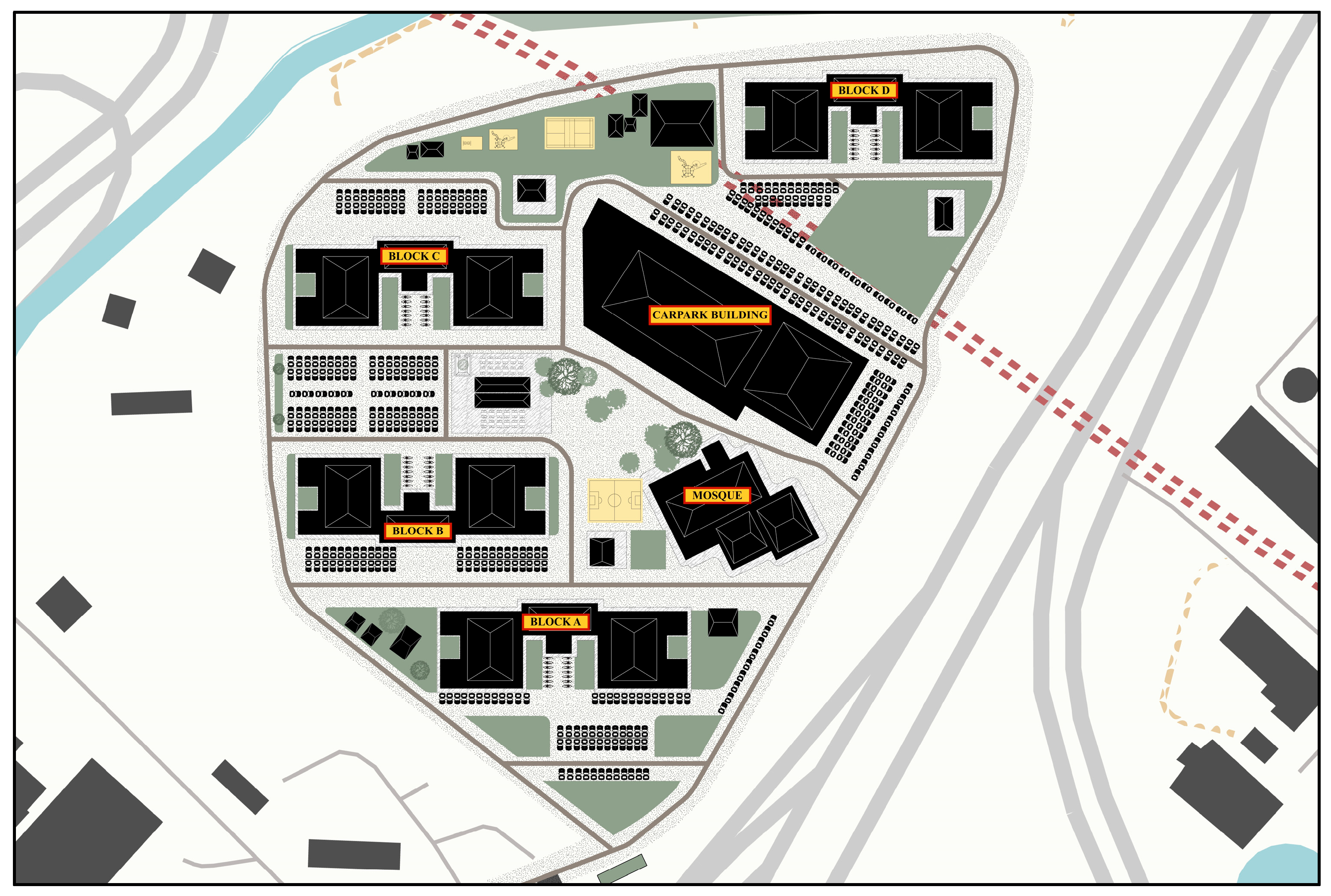
The study was conducted in a People’s Housing Project (PPR) community in Kuala Lumpur, PPR Raya Permai (see
Figure 1), which is one of the low-income, high-density neighborhoods in Malaysia. Participant recruitment was coordinated with the local Ketua Kampung (Head of Village), who disseminated study information for one month via the neighborhood WhatsApp group and a poster. Interested parents and children were invited to an information session at which researchers outlined the study aims, activities (child-led walks and mental mapping), expected time commitment, procedures for audio recording, confidentiality and data protection, potential risks or benefits, and the voluntary nature of participation (including the right to withdraw at any time without penalty). Families were then given one week to consider participation. All participants were recruited voluntarily, with both children and their parents or guardians providing signed informed consent before participation. Parents were invited to accompany their children during activities to ensure comfort and safety.
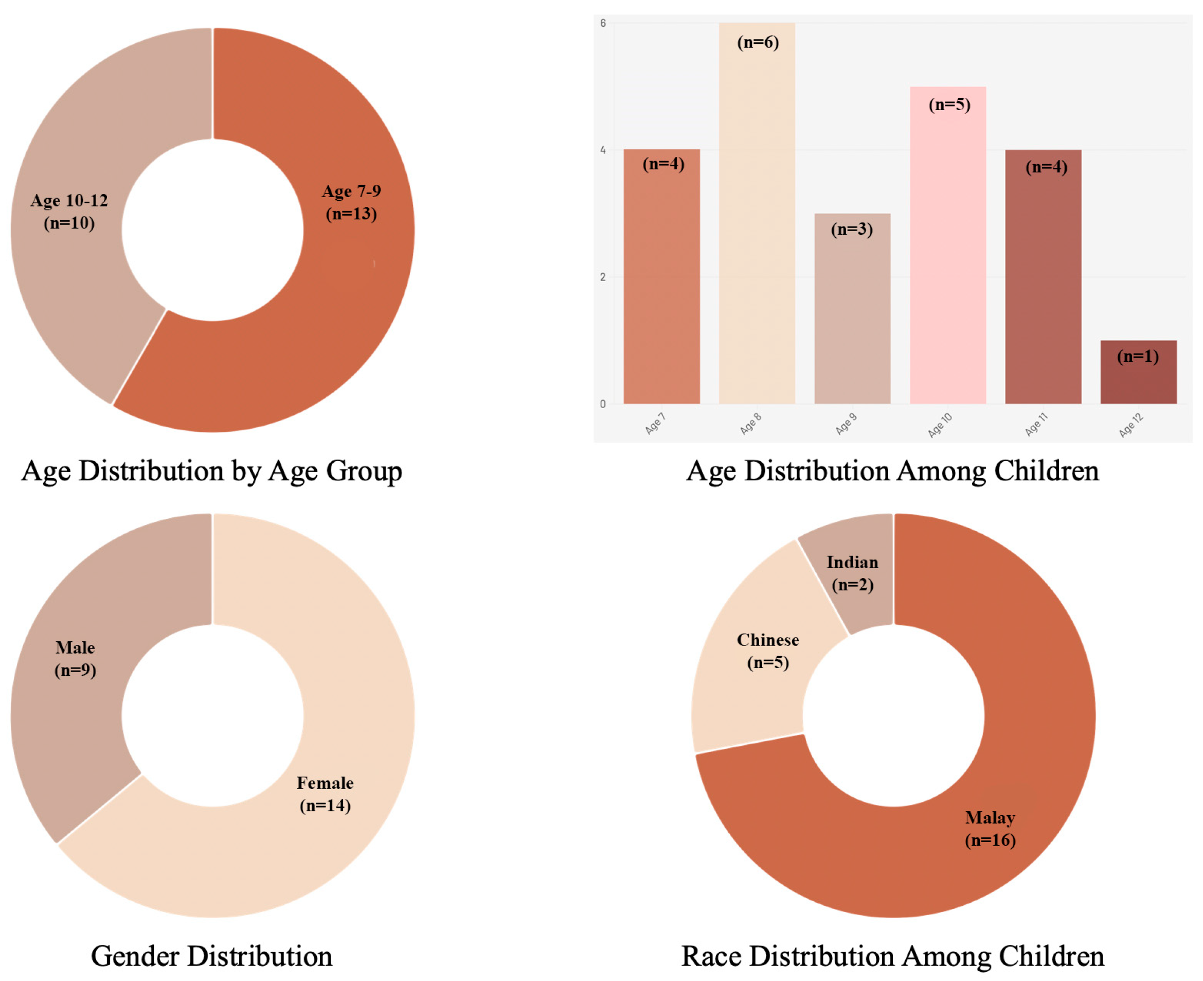
A total of 23 children aged between 7 and 12 years participated. Participant demographics are presented in
Figure 2. All children completed both the child-led walks and the mental-mapping exercises. Data collection continued until thematic saturation was reached.
All data were managed and analyzed using NVivo software. All conversations were translated from Malay and Chinese into English and imported into Nvivo. Analysis began with familiarization with the transcripts. Using an inductive approach, salient quotations were coded and organized under a provisional “child” code family. Coding was then iteratively reviewed and refined, and codes were grouped into themes. For the mental-mapping, all drawings were scanned and imported into NVivo. Each map was examined in detail and accompanied by analytic notes. The same inductive coding (anchored to the “child” code family) was applied, followed by thematic categorization to consolidate patterns across cases. Finally, evidence from the child-led walks and maps was triangulated through thematic cross-validation and integration. All children’s identities were anonymized, with names replaced by coded identifiers to ensure confidentiality and protection. The findings are presented under overarching themes that reflect how children perceive, navigate, and interact with their neighborhood environments.
4. Results
4.1. Findings of Child-Led Walk
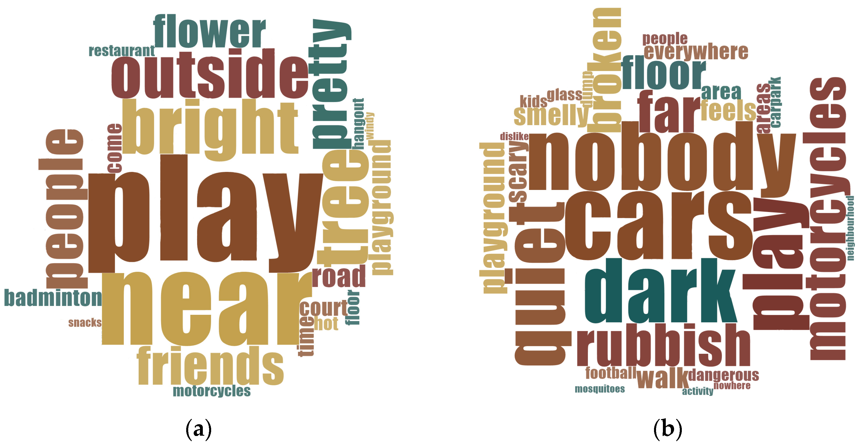
Figure 3 illustrates children’s perspectives on their neighborhood environments, distinguishing positive from negative experiences. The word clouds illustrate that children preferred outdoor play over indoor activities. Their choices of places were influenced by brightness, proximity, and the presence of people, including neighbors, vendors, friends, or peers, which heightened their sense of safety. Locations that were visually appealing, either through mural art, decorative lighting, or natural elements like flowers and trees, were described with enthusiasm and often referred to as “beautiful” or “happy places.”
Conversely, children also reported negative experiences during the walk. They avoided places that felt isolated or overly quiet. A major concern raised was the dominance of vehicles, cars and motorcycles, which occupied streets, playgrounds, and green spaces. This overuse of space for parking and traffic limited children’s opportunities for play, social interaction and free movement, reinforcing a sense of spatial marginalization. Children also noted poor maintenance of facilities, including broken flooring, damaged playground equipment, and futsal courts lacking safety fences. Additionally, scattered rubbish was frequently mentioned as a sign of neglect to enjoying their surroundings. Such conditions contributed to the children’s perception of certain areas as unwelcoming or unsafe, further restricting their range of accessible and enjoyable spaces.
4.1.1. Everyday Hazards and Unsafe Conditions
Across all three neighborhoods, children vividly described the unsafe and deteriorating conditions of their everyday environments. Open drains emerged as a recurring concern. They were not only perceived as dirty and unpleasant but also as dangerous, harboring animals that posed physical threats: “I don’t like the drainage because it has no cover, and monitor lizards crawl out of it. I was bitten by a monitor lizard before” (PPRRP06, Girl, aged 11, Malay). Several other children nodded in agreement, remarking that they avoided walking too close to drains out of fear.
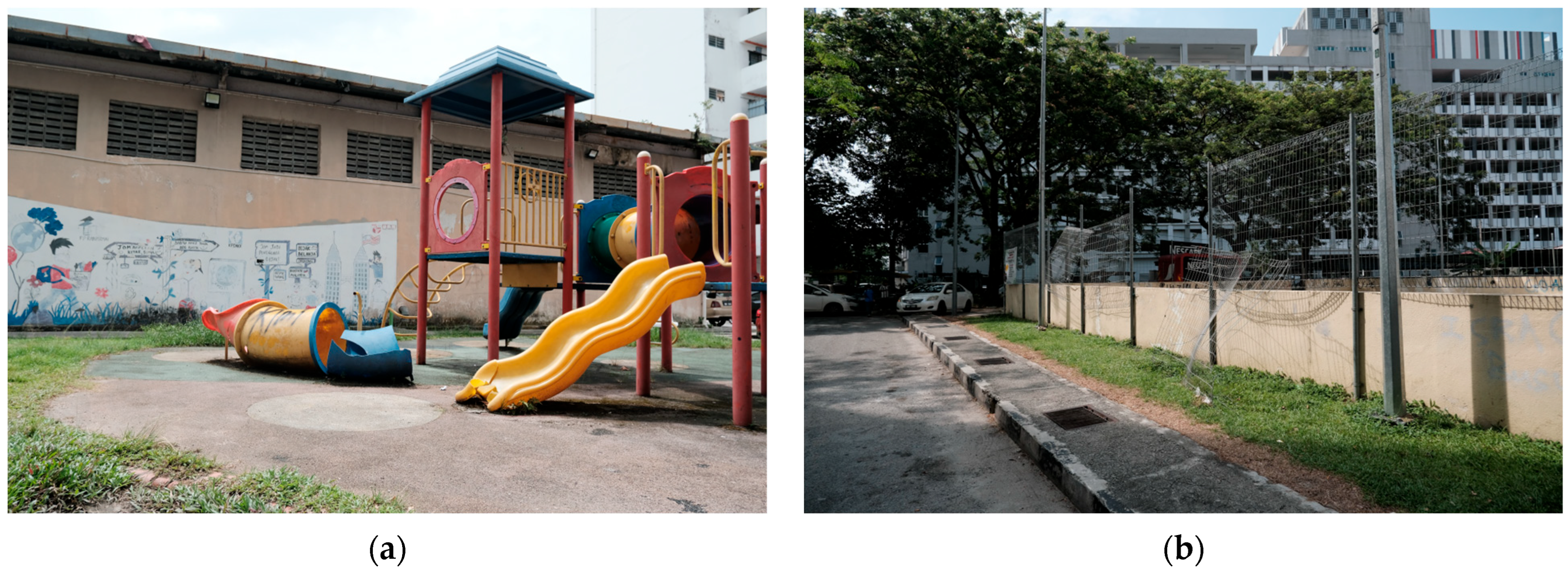
Playgrounds, although treasured as central gathering places, were described as double-edged spaces, places of joy but also of injury. Broken slides, rusted swings, and scattered nails made them hazardous: “The slide is my favorite. But most of them are spoiled and fallen down on the floor. There are nails on the floor too” (PPRRP23-Girl-aged 12-Chinese) (
Figure 4a). One child added during the walk, “When I run here, sometimes I get cut, so my mom says don’t play, but I still come because all my friends are here” (PPRRP11-Girl-aged 8-Malay).
Sports facilities, particularly futsal courts, were equally valued yet equally compromised. Children celebrated them as spaces of competition and camaraderie but lamented their deteriorated state: “The futsal court is the best! Me and my friends have matches every day. But the ground is already cracked. And there is no soccer net, the fences in the court are also falling down, it is very sharp and dangerous now, because I’m worried that if I have, it will poke into me” (PPRRP22-Girl-aged 11-Malay, PPRRP21-Girl-aged 10-Malay). Others pointed out that they had to bring makeshift equipment, such as plastic bottles for goalposts, because facilities were incomplete.
Traffic danger was another pervasive theme. Cars and motorcycles intruded into courtyards and empty spaces, obstructing play and creating constant anxiety. “Sometimes we play on the road. But I don’t like cars and motorcycles here. I am afraid to get hit” (PPRRP21-Girl-aged 10-Malay). Another child observed, “I don’t like motorcycles because they block the empty spaces in the buildings, leaving no place for us to play. We also can’t pass through because they are blocked” (PPRRP01-Girl-aged 8, Chinese) (
Figure 4b). Children noted that even when they were careful, motorcycles sped past unpredictably, reinforcing their vulnerability.
4.1.2. Safety Through the Role of “Eyes on the Street”
Children consistently equated safety with the presence of others. When spaces were animated by people, whether peers, parents, or passersby, they felt protected. Playgrounds, despite their hazards, were considered safe because they were lively: “We like to play at the playgrounds, because there are a lot of people here” (PPRRP14-Girl-aged 11-Malay, PPRRP13-Boy-aged 7, Chinese). Similarly, one child said, “I like hanging out at the playground with my friends” (PPRRP11-Girl-aged 8-Malay).
By contrast, deserted or dimly lit places provoked fear. “…my parents say it is very dangerous, because it is quite dark even during daytime, and nobody is there to watch us…” (PPRRP20-Boy-aged 10-Malay). Another child articulated the same unease more bluntly: “Quiet places, place that has no people, places that are dark, places that are confined” (PPRRP19-Boy-aged 8-Malay). The basement carpark illustrated this ambivalence most clearly: it was attractive for shade and privacy, but children acknowledged its dangers: “Oh oh, I also like to play at the basement carpark, because it is not hot… But my parents say it is very dangerous, because it is dark during day time, and nobody is there to watch us” (PPRRP20-Boy-aged 10-Malay) (
Figure 5).
4.1.3. Comfort, Amenities, and Aspirations for Better Spaces
Beyond immediate safety, children highlighted the lack of comfort and amenities in their neighborhoods. Shade and seating were recurring concerns. “It’s quite hot sometimes, the garden here is pretty, but not enough place like a hut for us to hangout or spend time here. I wish to have more huts, so we can relax here, spend time, or eat here with these nice views” (PPRRP09-Girl-aged 8-Indian). Another added, “Have a place to sit. Sometimes we get tired and have nowhere to sit. So we just sit on the floor, but the floor is hot…” (PPRRP22-Girl-aged 11-Malay). Others noted that “There’s nowhere to sit outside, except for the steps” (PPRRP14-Girl-aged 11-Malay).
Green spaces were seen as vital for play, relaxation, and family time. “I like trees because they provide fresh air and a cool breeze” (PPRRP02-Girl-aged 7-Malay).; “More trees would be good. Then we could have picnics under the tree, because it will have wind, it feels best” (PPRRP21-Girl-aged 10-Malay). However, children also flagged accessibility issues: “My sister and I like to go to the garden because it’s so nice there. But it’s a bit too far for us to go alone” (PPRRP14-Girl-aged 11-Malay).
Esthetic qualities influenced children’s pride in their neighborhood. Graffiti, in particular, was viewed negatively: “There’s a lot of graffiti on the walls, and some of it looks really scary. It makes our houses look ugly” (PPRRP12-Girl-aged 9-Malay). By contrast, even ordinary or “plain” features gained significance when they were near children’s homes, reinforcing the role of proximity and familiarity in shaping their attachment.
4.1.4. Negotiating Play in Constrained Environments
The shortage of designated, safe spaces pushed children to improvise. Streets, narrow pedestrian lanes, and carparks often doubled as play zones, despite their risks. “Sometimes we play on the roads, like racing to see who’s the fastest or just chasing each other. But we always have to be careful and watch out for cars, especially motorcycles, they go so fast, and they don’t look at us” (PPRRP11-Girl-aged 8-Malay). Another child added: “I don’t like small pedestrian lanes, they are very narrow and cause congestion” (PPRRP02-Girl-aged 7-Malay).
Yet, these improvised spaces were also sources of joy, bonding, and creativity. Children valued the flexibility of claiming whatever spaces were available, even when they were unsafe or contested. As one girl concluded during her walk, “We just find anywhere to play, even if it’s not good, because we still want to be outside with our friends” (PPRRP22-Girl-aged 11-Malay).
4.1.5. Summary of Child-Led Walk Findings
The child-led walks revealed a neighborhood environment characterized by contradiction. Playgrounds, futsal courts, and carparks were the most frequented and socially meaningful spaces, yet also the most unsafe due to traffic, poor maintenance, and environmental hazards. Children framed safety less in terms of infrastructure than in terms of visibility and social presence, preferring places where others were around. At the same time, they voiced aspirations for shaded seating, greenery, and better-maintained facilities. These findings indicate that children actively negotiate risk and opportunity in their everyday environments, creatively appropriating even unsafe spaces while simultaneously articulating clear visions for safer, more supportive neighborhood design (see
Table 1).
4.2. Findings of Mental Mapping
Children’s mental maps revealed how they perceive their neighborhoods not as literal replications of space but as lived realities, blending practical routes with emotional geographies. Their drawings captured constant tensions between hazard and opportunity, deprivation and creativity, fear and attachment. Cars, play areas, natural elements, vendors, and human figures appeared with varying levels of detail, each highlighting children’s awareness of both risks and affordances embedded in their surroundings.
4.2.1. Cars, Traffic, and the Domination of Streets
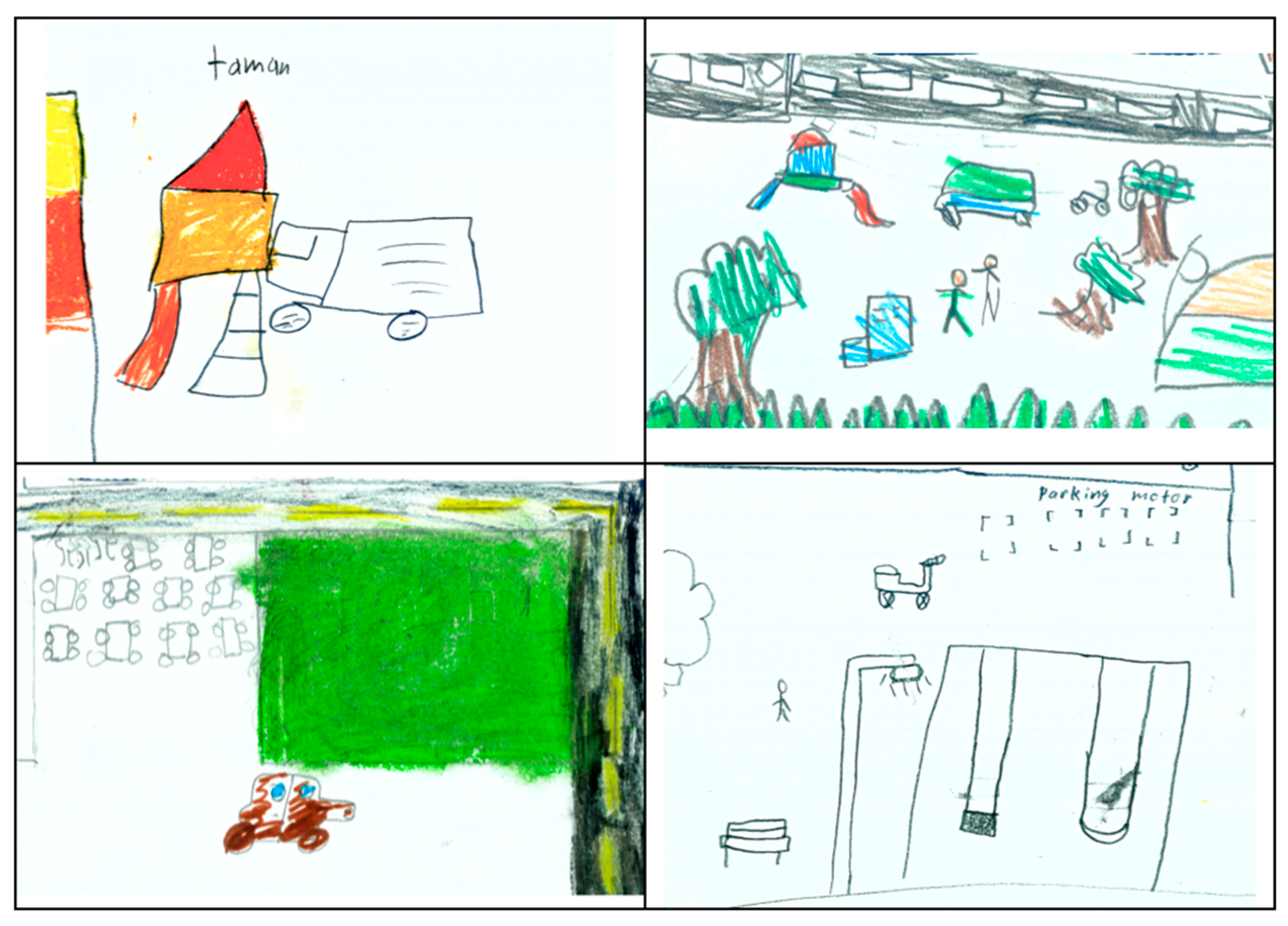
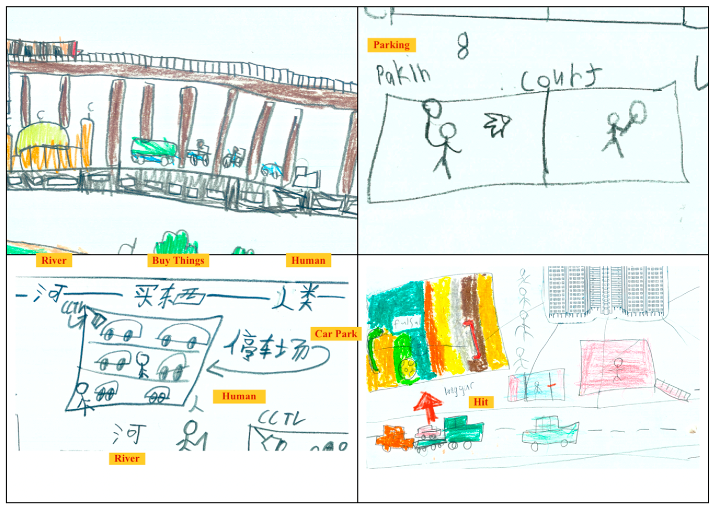
The most striking element in almost every drawing was the overwhelming presence of cars and motorcycles. Streets were represented as congested arteries, filled with vehicles that children identified as a central part of their daily routes. Cars appeared not only on main roads but also within playgrounds, parking spaces, and even courtyards, spaces supposedly reserved for play. In several drawings, cars were sketched colliding with playground equipment, such as slides, swings, and even benches, symbolizing how motorized traffic intrudes into spaces that children otherwise claim as their own.
Parking areas were frequently highlighted as both unavoidable and paradoxical spaces. Children indicated them as unsafe and disruptive, yet also as places where they improvised play, such as racing, chasing, or riding bicycles. One drawing included a cluster of cars parked tightly together beside a slide, with children represented as stick figures weaving between them, suggesting both the creativity and risk inherent in their everyday mobility. Another child added directional arrows to illustrate how motorcycles “cut through” the neighborhood, emphasizing the speed and unpredictability of these vehicles.
These depictions reveal that, for children in low-income, high-density neighborhoods, traffic is not a distant hazard but an omnipresent reality that infiltrates every corner of their environment, shaping their movement and constraining their freedom (see
Figure 6).
4.2.2. Playgrounds Under Pressure
Playgrounds were consistently marked in the drawings, often positioned as central gathering points. Yet their representation carried a dual meaning: they were the most beloved spaces, but also among the most dangerous. Slides were drawn crooked, sometimes tilted or broken, while swings were sketched without seats or with jagged lines suggesting missing parts. One child drew a car partially mounted on a slide, vividly representing the collision between intended play space and vehicular encroachment.
Despite these dangers, children continued to draw themselves and their peers playing in these areas, indicating the strong social pull of playgrounds. In one drawing, a child depicted a group of stick figures gathering around a swing with scattered nails on the ground, with an accompanying caption describing how they “still go there because everyone is there.” This juxtaposition illustrates the resilience of children’s social lives; even degraded and unsafe playgrounds retain importance because they represent spaces of interaction and community belonging (see
Figure 7).
4.2.3. Nature, Birds, and the Scary Tree
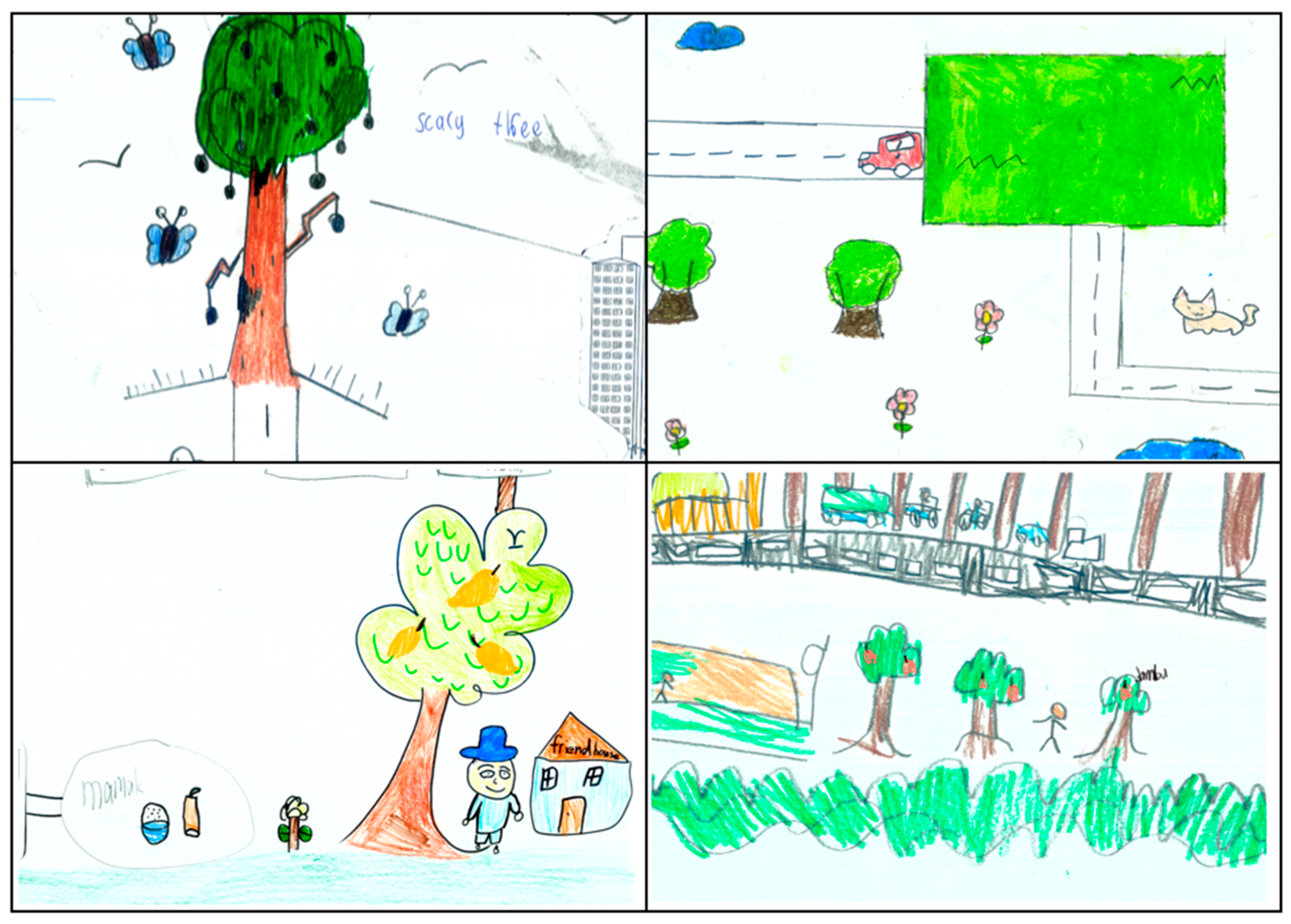
Natural elements were recurring motifs in the children’s maps, often drawn with care and color even when other elements were sketched more abstractly. Grass fields were frequently represented as rectangles or patches of green, signaling their importance as open areas for running, football, or resting. Flowers were drawn in bright colors, symbolizing beauty within otherwise congested neighborhoods, while birds were often sketched flying above roads or trees, suggesting freedom in contrast to the children’s restricted mobility.
Trees were represented with ambivalence. Some children drew large trees with wide canopies, under which they placed themselves and friends, indicating shade and social gathering. Others drew fruit-bearing trees, labeling them with words like “mango” or “jambu,” highlighting their sensory and seasonal appeal. Yet, one drawing depicted a “scary tree,” drawn with dark lines and twisted branches, showing how overgrown natural elements could also carry associations of fear or danger. Such drawings suggest that children’s relationship with nature is both affectionate and cautious, shaped by sensory experiences of shade, breeze, and fruit, but also by shadows and unfamiliarity (see
Figure 8).
4.2.4. Vendors, Human Sticks, and Everyday Social Life
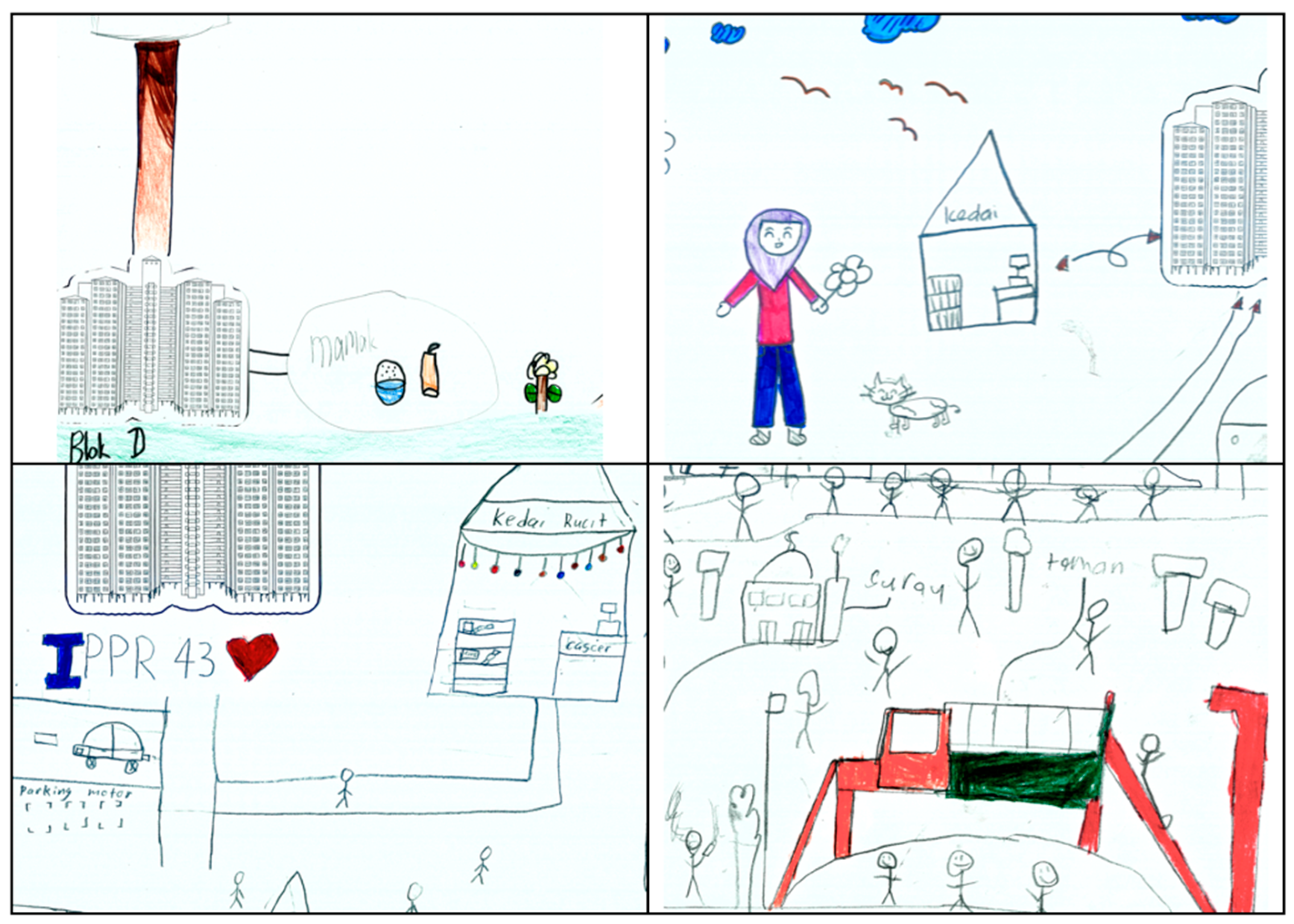
The presence of people was a defining feature of the drawings, captured in the form of “stick humans.” Children drew themselves, friends, parents, and siblings, often in the company of informal vendors. Food stalls were sketched as small boxes or rectangles with bright colors, usually located at street corners or near playgrounds. Vendors were depicted as landmarks, signaling familiarity, affordability, and social significance in the children’s daily lives.
These human figures were not mere additions to the scenery but central to how children mapped meaning into space. They marked where interactions took place, where food could be bought, and where supervision was present or absent. In one drawing, a child represented himself walking to a playground, passing by three vendors, and labeled them with the types of food sold. This illustrates how commercial life becomes inseparable from children’s mobility patterns, providing both attraction and orientation in their daily routes (see
Figure 9).
4.2.5. Lack of Amenities and Comfort
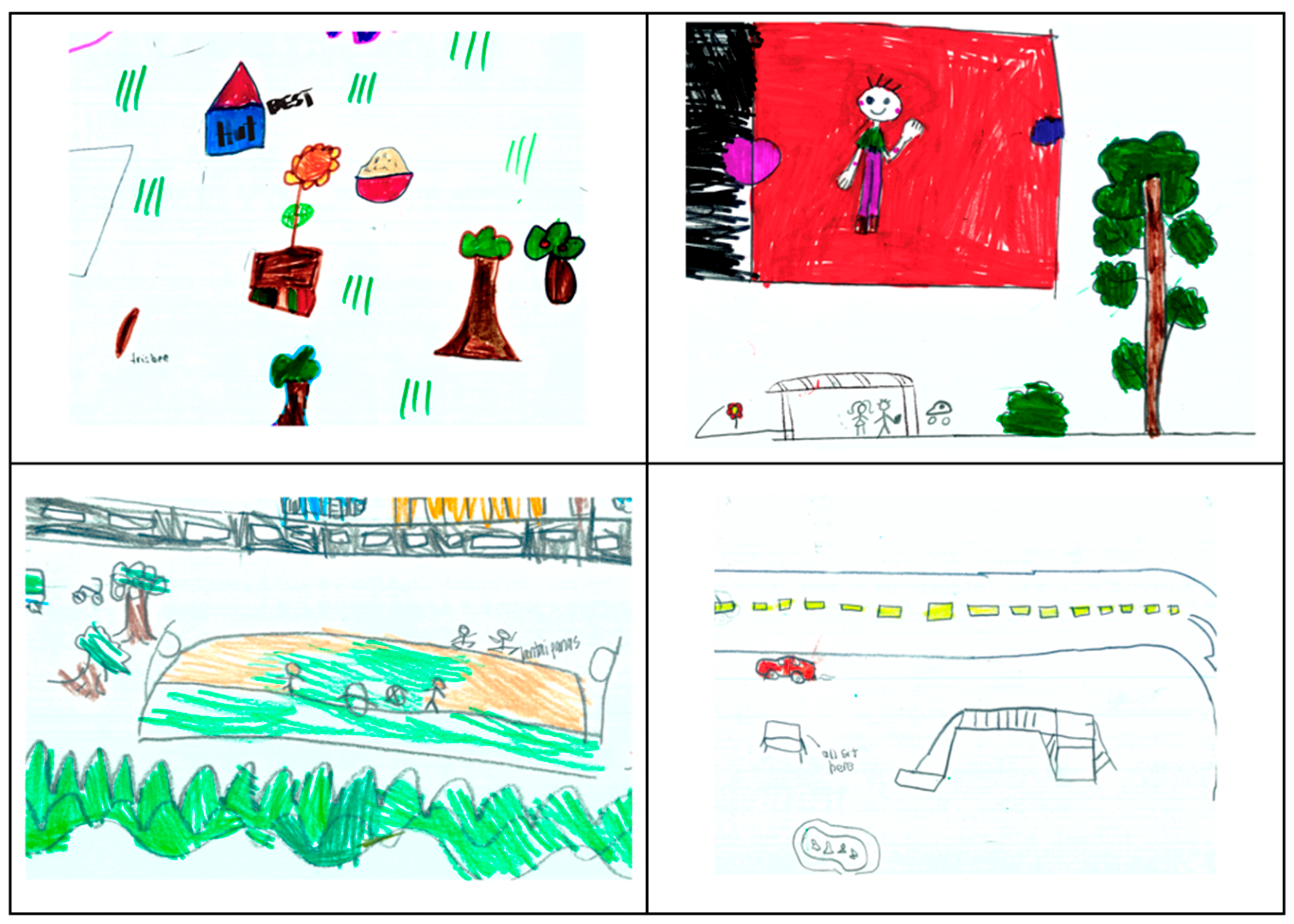
Another recurrent theme was the scarcity of seating and resting places. Benches were either absent in the drawings or appeared only a few, often further elaborated as “we sit here because nowhere else.” One child drew several stick figures sitting directly on the ground beside a wall, with arrows pointing to the “hot floor,” reflecting discomfort and lack of shaded rest areas.
The absence of supportive amenities extended beyond seating. A few drawings included covered walkways, shelters, or shaded huts. When present, these were highly valued: one child added a simple hut beside a garden and labeled it “best place to relax.” The scarcity of such features highlights the deprivation of basic comfort in environments where outdoor play is already contested and risky (see
Figure 10).
4.2.6. Children Playing on Streets and Parking Areas
Perhaps the most powerful motif across the drawings was children’s adaptation to constrained environments. Streets, parking lots, and even basements were represented as play zones, often crowded with cars. Stick figures were drawn chasing each other between parked vehicles, playing ball in narrow lanes, or cycling in circles within parking areas. These images highlight the improvisational nature of children’s play in deprived contexts; despite risks, they continued to appropriate whatever spaces were available.
The drawings also emphasized danger alongside play. Some children drew red lines or arrows near cars to indicate potential crashes. This illustrates how children are simultaneously aware of hazards and willing to navigate them for the sake of sociability and recreation (see
Figure 11).
4.2.7. Summary of Children’s Mental Mapping Findings
The mental maps reveal a neighborhood landscape dominated by vehicles, deprived of safe and adequate play infrastructure, and lacking supportive amenities. Cars invade playgrounds, slides collapse under neglect, and streets become risky but indispensable arenas of play. Yet, alongside these hazards, the drawings also revealed spaces of meaning, including trees offering shade, flowers and birds symbolizing beauty, vendors providing familiarity, and friends populating every corner.
Children’s representations highlight the paradox of life in low-income, high-density neighborhoods, environments that are simultaneously feared and loved, unsafe yet indispensable (see
Table 2). Their maps articulate both the material deficits of their surroundings and the imaginative strategies they employ to adapt and create social worlds within them.
4.3. Methodological Triangulation of Findings
The comparative analysis of child-led walks and mental mapping reveals both convergence and divergence in how children perceive and experience their neighborhoods. While the walks provided detailed accounts of immediate hazards and practical constraints, the drawings highlighted intangible elements such as attachment, familiarity, and appreciation, thereby revealing the layered meanings children assign to their environments. Together, these methods triangulate the complexity of children’s spatial realities in low-income, high-density neighborhoods.
Safety emerged as the most dominant theme in the walks, where children emphasized open drains, broken facilities, sharp fencing, and constant intrusion of cars and motorcycles. In the mental maps, safety concerns were also prominent but visualized more symbolically, with cars dominating playgrounds and slides or “scary trees” marking fearful places. While verbal accounts foregrounded immediate risks, the drawings communicated how these dangers permeate the broader landscape of children’s everyday mobility.
Nature was marginal in the walks but central in the drawings. While few children verbally highlighted greenery, their maps consistently included trees, grassy fields, flowers, and birds. These depictions signal not imaginative escape but rather appreciation and attachment: nature was marked as a source of shade, comfort, and beauty within otherwise deprived environments.
Comfort was voiced strongly in the walks, with repeated calls for shaded huts, benches, and cooler resting areas. Yet, comfort rarely appeared in drawings, suggesting that it is perceived as a daily practical concern rather than an enduring marker of neighborhood identity.
Sensory dimensions (graffiti, brightness/darkness, quiet vs. lively, fresh air) were captured in both methods. Walks linked these elements directly to feelings of safety and discomfort, while drawings expressed them more abstractly, with graffiti walls, colorful flowers, or the presence of birds.
Accessibility also revealed methodological differences. In walks, children emphasized blocked pedestrian paths, congested lanes, and difficulties reaching distant gardens. In drawings, however, accessibility was often symbolized through landmarks such as vendors, roads, and parking areas. These features were not merely functional but embedded with social meaning, orienting children within their neighborhoods and reflecting a sense of belonging through everyday routines.
Table 3 summarizes these findings.
5. Discussion
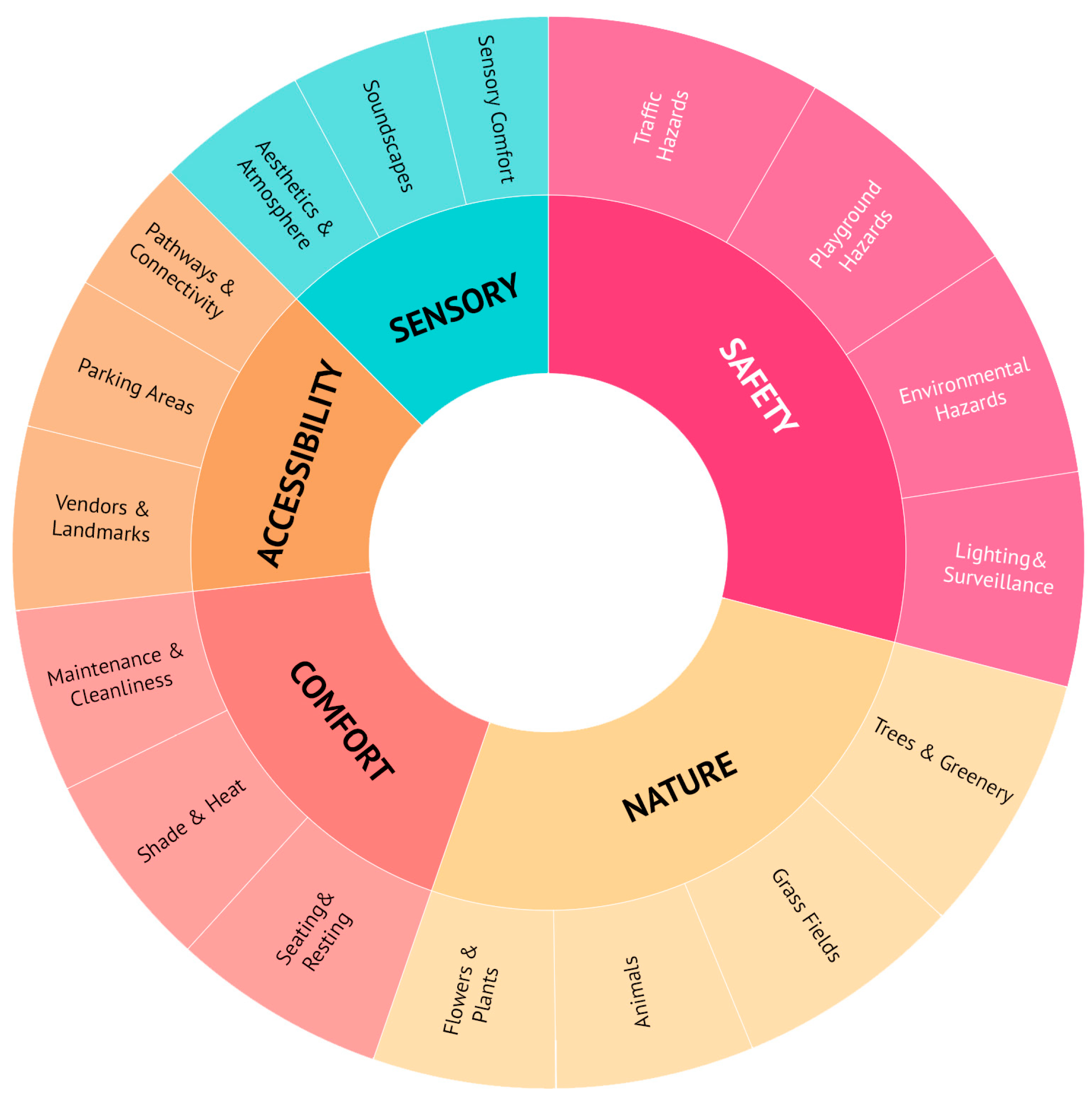
This study aimed to investigate how children in low-income, high-density neighborhoods experience and use outdoor environments, and to identify the environmental affordances that shape their everyday independent mobility and autonomy (see
Figure 12). By combining child-led walks with mental mapping, it foregrounds children’s perspectives in ways that both affirm and extend existing affordance frameworks. The findings demonstrate that independent mobility and autonomy are not discrete phenomena, but rather co-constituted through the interplay of material, social, and affective dimensions of neighborhood life.
The child-led walks highlighted the limits of independence in material terms. Hazards such as open drains, broken slides, cracked futsal courts, and cars encroaching on play areas dominated children’s accounts. These findings resonate with studies linking environmental neglect and traffic danger to diminished independent mobility (
Karsten 2002;
Dennis 2006;
Castonguay and Jutras 2010). Yet, as in
Valentine and McKendrick’s (
1997) and
Husin et al.’s (
2021) work, children in disadvantaged contexts still spent extensive time outdoors, appropriating even degraded or risky environments for play. Independence mobility here was less about empowerment than about negotiation, with children relying on strategies such as staying in groups or seeking out spaces with informal surveillance. This finding extends previous literature by showing that in low-income Asian settings, independent mobility is sustained not by infrastructure but by relational forms of safety.
In contrast, the mental mapping revealed how autonomy was nurtured through affective and symbolic affordances. Children consistently highlighted trees, flowers, birds, murals, and vendors, confirming prior research on the value of sensory and esthetic cues in children’s place attachment (
Herrington and Studtmann 1998;
Moula et al. 2021). Even ordinary or deteriorated features were imbued with meaning when located near homes, reflecting the child-centered reinterpretation of marginal spaces noted by
Loebach and Gilliland (
2019). This suggests that autonomy is not reducible to geographic range or unsupervised travel but is equally tied to the capacity to assign meaning, feel pride, and experience agency in the everyday environment.
Children’s accounts of their neighborhoods revealed affordances that were simultaneously enabling and constraining. On the one hand, courtyards, futsal courts, block basements, and shaded alleys provided opportunities for play, exploration, and peer interaction. On the other hand, these very settings were marked by hazards: open drains, broken slides, cracked surfaces, scattered rubbish, and the intrusion of vehicles into play areas. From
Gibson’s (
1979) perspective, these features represent conditional affordances; what they offer depends on both the physical form and the perceiver’s abilities and judgments.
Existing studies of children’s mobility often emphasize barriers such as traffic danger or the absence of facilities (
Karsten 2002;
Castonguay and Jutras 2010;
Clark and Moss 2017). Our findings confirm these challenges but extend the discussion by showing that affordances in disadvantaged neighborhoods are rarely unidimensional. The same courtyard affords both
danger and
play; the same parking lot affords both risk and social congregation. This duality illustrates
Högskolan and Kyttä (
2003) notion of “ambivalent affordances,” whereby children actively negotiate environments that are simultaneously threatening and indispensable. Moreover, children’s strategies for mitigating risks, staying in groups, occupying visible locations, or depending on “eyes on the street” (
Jacobs 1961) demonstrate that affordances cannot be divorced from the social context. A cracked futsal court may afford safe play only when peers are present; an alley may feel navigable only with neighbors nearby. In this way, affordances are dynamically co-produced by environmental form, social relations, and children’s adaptive agency.
While physical hazards constrained movement, the mental maps revealed that autonomy is sustained through affective and symbolic attachments. Children consistently highlighted natural elements such as trees, flowers, and grass fields, aligning with research that underscores the restorative and esthetic qualities of green space (
Herrington and Studtmann 1998;
Chawla 1988). Vendors, murals, and neighborhood landmarks were also drawn prominently, suggesting that autonomy derives not only from the ability to move freely but also from the ability to orient oneself within a landscape of familiarity and belonging. This perspective resonates with
Heft’s (
1989) functional taxonomy of affordances, where the environment provides not just opportunities for action but also cues for meaning and identity.
For children in constrained settings, murals or vendors may serve as anchors of psychological safety, offering what
Moula et al. (
2021) describe as “aesthetic affordances” that enrich the lived experience of place. Our findings extend this insight by showing how children imbue even marginal or ordinary features, like basements or shaded corners, with symbolic value. These sites become not merely backdrops but active supports for autonomy, enabling children to express identity, claim belonging, and reconfigure stigmatized spaces into meaningful ones. Importantly, these attachments illustrate that autonomy is not reducible to distance traveled or the absence of adult supervision. Rather, autonomy involves the psychological freedom to appropriate spaces, reinterpret them, and transform them into sources of comfort and pride. In this sense, autonomy is as much about how children feel in relation to their environments as it is about where they can go.
A central contribution of this study lies in demonstrating that independent mobility and autonomy are inseparable dimensions of children’s neighborhood experience. The dominant tendency in the literature has been to measure mobility as the capacity to travel independently (
Christensen et al. 2018;
Weir 2023) and autonomy as decision-making power or self-determination (
Ryan and Deci 2020;
Han et al. 2022). By treating these constructs separately, research risks overlooking how children themselves experience them as intertwined. Our findings reveal that mobility without affective safety does not guarantee well-being. For example, children’s ability to access a futsal court was undermined by its dilapidated condition and the threat of vehicular intrusion; here, physical mobility was possible but not accompanied by a sense of security or belonging. Conversely, affective attachment without mobility may sustain pride but restrict exploration; for instance, shaded corners may anchor children’s sense of identity, but do not expand their opportunities for movement or peer exchange. It is only in the integration of mobility and autonomy, when children can move with both physical freedom and emotional assurance, that environments truly support well-being.
This relational understanding advances existing environmental affordance frameworks in two important ways. First, it demonstrates that affordances should not be assessed solely in terms of functional opportunities (e.g., play equipment, walkable paths) but also in terms of affective and symbolic qualities that shape whether children choose to engage with those opportunities. Second, it emphasizes that autonomy and mobility are not endpoints on a continuum of dependence but are co-constituted processes. Children achieve independence through relational security, and they exercise autonomy through movement that is emotionally grounded.
By bringing these dimensions together, this study situates affordances at the intersection of physical conditions, social dynamics, and affective meaning. It moves beyond binary categorizations of “safe vs. unsafe” or “independent vs. dependent” to show how children actively negotiate environments that are simultaneously constraining and enabling. Mobility without autonomy risks disempowerment, while autonomy without mobility risks isolation. In highlighting this tension, the study offers a conceptual refinement of affordance theory as applied to disadvantaged childhoods: autonomy and independence are not parallel constructs but mutually reinforcing elements of everyday practice. Crucially, it contributes a comprehensive perspective grounded in children’s lived experiences of low-income, high-density housing in Southeast Asia, a regional context that remains underexplored in child-friendly urban studies.
Taken together, the findings extend current knowledge in three ways. First, they reveal the ambivalence of affordances in low-income, high-density neighborhoods, where the same settings simultaneously enable and constrain children’s practices. Second, they highlight the affective dimension of autonomy, demonstrating that belonging, pride, and comfort are as essential as infrastructural safety. Third, they advance a relational framework that integrates mobility and autonomy, positioning children’s experiences as simultaneously physical, social, and emotional.
By returning to the study’s objectives, the discussion underscores that children’s neighborhood experiences cannot be understood solely in terms of hazards or access. Rather, they must be interpreted through the entanglement of independence and autonomy as lived realities. This integrative perspective enriches both theorizations of affordances and practical debates on child-friendly urban design, offering a nuanced lens for understanding how marginalized children navigate and remake their environments.
6. Conclusions
This study demonstrates that children in low-income, high-density neighborhoods inhabit environments that systematically constrain their independent mobility while simultaneously demanding creative strategies to sustain autonomy. The child-led walks exposed the severity of infrastructural neglect that directly limits children’s spatial freedoms and reinforces their marginalization in the urban realm. In contrast, the mental maps revealed how children continue to construct autonomy through affective attachments even when their environments fail to provide adequate safety or comfort. This duality underscores a critical gap in urban policy and planning: the persistent framing of children’s mobility either as physical independence or psychological agency. The findings here argue for a comprehensive perspective that recognizes autonomy and independence as interdependent, situated within both the material and symbolic landscapes of children’s neighborhoods.
The study’s scope introduces certain limitations. Recruitment through local networks may have privileged families who were more engaged with community structures, and the presence of parents at a distance, while necessary for ethical reasons, may have subtly influenced children’s behavior. Importantly, the findings suggest concrete ways in which existing child-centered planning frameworks can be adapted to better support both autonomy and independent mobility. Frameworks such as the Child-Friendly Cities Initiative or national housing guidelines could be recalibrated to emphasize everyday routes and informal play spaces rather than focusing exclusively on formal playgrounds. In practice, this would mean incorporating design interventions that respond directly to children’s concerns: shaded seating and vegetation to mitigate heat stress; traffic calming and spatial segregation to reduce auto-pedestrian collisions in courtyards and play areas; improved lighting and maintenance to address safety perceptions; and the adaptive reuse of residual spaces, such as parking lots, into multifunctional child-friendly areas. By embedding these measures within existing frameworks, planning can move beyond symbolic recognition of children’s rights toward tangible improvements in their lived environments.
While this study is context-specific and based on a modest sample, its insights point to broader structural failings in the way urban environments are conceived for children. Future research must extend these analyses across diverse socio-economic contexts and adopt mixed, longitudinal approaches to capture the evolving interplay between environment, mobility, and autonomy. Unless children’s voices are systematically integrated into planning processes, urban policies will continue to privilege density and efficiency at the expense of children’s rights to safe, supportive, and meaningful neighborhood spaces.
