Article

The Most Advanced Hydraulic Techniques for Water Supply at the Fortresses in the Last Period of Al-Andalus (Thirteenth to Fifteenth Century)

by
Luis José García-Pulido
1,2,* and
Sara Peñalver Martín
3
1
Department of Art and Architecture, University of Málaga, 29016 Málaga, Spain
2
Laboratory of Archaeology and Architecture of the City (LAAC, EEA, CSIC), 18010 Granada, Spain
3
Architect, University of Málaga, 29016 Málaga, Spain
*
Author to whom correspondence should be addressed.
Submission received: 5 March 2019 / Revised: 5 May 2019 / Accepted: 9 May 2019 / Published: 15 May 2019
(This article belongs to the Special Issue Andalusi Architecture: Shapes, Meaning and Influences)

Abstract

:
Due to the conflicts that existed among the kingdoms of the Iberian Peninsula during the Middle Ages, the territories of al-Andalus were protected with defensive architecture that played an influential role on the landscape. The development of these fortresses was necessarily linked to water, either because of the strategic control of a hydraulic resource or because of the need to provide to inaccessible places, as it is often the case of the emplacement of these constructions. The study of their implantation in the territory and the hydraulic elements that they preserve has revealed quite diverse systems of water supply. This paper presents the comprehensive overview that emerged after verifying that many of the existing cisterns, rather than being autonomous and isolated elements, as has often been considered, are strongly related to the organization and development of the fortresses, sometimes located at the end of complex and advanced hydraulic networks, closely linked to the topography of each place. This study is devoted to the water supply systems of some of the most significant fortresses in the last territories of al-Andalus, corresponding to the Nasrid kingdom of Granada (1238–1492).

1. Introduction

As a general rule, the development of fortified settlements and defensive architecture in al-Andalus deals with very specific and conditioning topographical elements, in search of high places with an extensive view surveilling the surrounding territory and a controllable access. While favouring their position of defence and control, these places implied a series of difficulties to assure basic goods for a prolonged settlement. One of these essential resources is water.
Building a fortress at a high position always meant an additional difficulty to the stable access to water, which is a key element both in the construction and maintenance of defensive structures and sustaining life inside them. In addition, many of them were established to control the access to surface or groundwater resources, ensuring the protection of springs, wells, water channels, and even rivers (Pavón Maldonado 1990). If this was not possible due to other strategic or defensive issues, there was still the possibility of transporting water from another place or collecting rainwater. In many cases, there was a combination of all or some of these factors.
In this sense, facilities for water storage such as the cistern (called aljibe in Spanish, from Arabic al-jubb) and the pond (Spanish alberca, from Arabic al-birka) played an essential role within a citadel (Spanish alcazaba, from Arabic al-qaṣaba) and other different types of fortresses in al-Andalus. They provided autonomy during periods of peace and resistance against prolonged sieges. In addition, they are usually one of the surviving structures of these fortresses, due to their solid construction and their fully or partially interred situation. This fact has favoured their preservation, as they are less exposed to erosion and have been protected with the deposition of earth and debris from the destruction of other surrounding elements.
This occurs on most of the Nasrid fortresses. During this kingdom, many pre-existing defensive structures were reoccupied and adapted to new border status, as well as others were built from the ground up. In this process, the construction techniques and the solution for the defence and the hydraulic supply followed-up with long traditions, coupled with the wide accumulated knowledge that the Nasrid kingdom gathers, due to the concentration of population and trade from Medieval Europe and the Maghreb.

State of the Art

Historically, water supply to fortresses has relied on digging wells to get water from the ground, or in building cisterns inside the walled enclosures to storage piped water or rainwater. These constructive resources have been used from Prehistory, as the excavation of the Spanish Bronze Age archaeological sites of Motilla del Azuer in Daimiel (Aranda Jiménez et al. 2008), with the oldest fortified well found in the Iberian Peninsula, or Peñalosa in Baños de la Encina (Onorato et al. 2008, pp. 297–316) have revealed.
Besides their situation in high places, harsh and dry environments present more challenges to obtain water. That is the case of many fortresses and fortified settlement situated in the Near East, where more complex hydraulic systems were developed for catching water; deeper wells and other ways of water transport are needed, as well as a high storage capacity. The settlement of Masada, built between 37–31 BC, is a well-known example of this situation. There, a huge network of 12 cisterns that could hold about 40,000 m3 was dug out at the base of the mountain, being fed by a system of dams and two aqueducts that collect and drive flood water from the surrounding ravines and gorges. Water was raised to other cisterns situated on the top of the cliff by human and animal force along a protected staircase (Netzer 1991).
Similar uses of wells, pipes, and aqueducts were put in use in Roman castra and castella established in the Limes Arabica, along the Via Nova from Petra to Aila, that were built in wadis, next to ravines that could be dammed, as well as during Byzantine and Umayyad times in the so-called ‘desert castles’. Some of them were conceived as palatial strongholds with amenities as baths, sometimes situated at a distance from them.
The Umayyad Palace of Amman (Jordan), built in the first third of the eighth century on the northern side of the hill of Jabal al-Qalʿa, include a large circular pool next to a public area that ensures water supply, with a capacity of 1368 m3. Next to it, a bath was excavated whose layout was similar to that which may be seen at Qusayr ʿAmra and other Umayyad buildings in Jordan (Almagro Gorbea 2010, pp. 475–513).
When the last surviving member of this dynasty, ʿAbd al-Raḥmān III, escaped to al-Andalus, he established the independent Caliphate of Córdoba. Then, in 936, the palace-city of Madīnat al-Zahrā was built next to the old capital of the Roman Betis region, choosing a place on the way of one of the main Roman aqueducts of Córdoba, which was refurbished to supply water to the Umayyad citadel (Ruggles 2008, pp. 152–53).
Among the fortresses built by the Almoravids in the eleventh and twelfth century in their expansion from Saharan Africa to the north of Morocco, Zagora is one of the oldest. It was raised to the west of Sijilmāsa in the third quarter of the eleventh century, on the right bank of Wadi Draʿa, which ensured its water supply (Meunié and Allain 1956, pp. 310, 322). In its northern part, which is the lowest, there were two irrigation channels parallel to the ravine. They passed through the enclosure running along the northern wall. Only about 20 m from the inner channel, a ḥammām (Arabic bath) was dug out in the mid-twentieth century, while the water supply to the upper area where the dwellings are located was done by hand.
The fortress of Tāsgimūt was also built by the Almoravids around 1125. There, the remains of an alberca with a horseshoe plant made of stone, in which the rainwater was collected, are preserved, as well as a fountain that guaranteed the supply of water to a big aljibe of square plan and made with large stones, in the southeast of the fortress (Cressier and Erbati 1999, p. 61; Basset and Terrasse 1927, p. 170). In addition, a ravine near the walls was crossed by a thick wall that could have served as a dam (Marcos Cobaleda 2010, p. 484).
The fortress of Tiguemi Ouguellid or Agadir Izenaguen is quite similar to the previous one. It is located in the Taourirt N Lhassene massif, near Wadi Sayad. In the lower part of the enclosure, there is an aljibe of 600 m3 fed by rainwater, covered with a masonry barrel vault with circular openings (Ricard 1938, pp. 644–45).
The fortress of Qaṣbat al-Naṣrānī in Jebel al-Naṣrānī, at the north of Meknes, has a defensive character. The lowest point of the enclosure, at the northern side, is the exit of a ravine, and up to three springs are protected there by two rectangular towers that overtake the wall (Berthier 1938, plan 3).
All these fortresses based their water supply on the protection of natural resources (springs, rivers, etc.) or artificial structures linked to water (wells or cisterns filled with rain or by channels), usually situated in the lower areas of the walled enclosures, and hence, water has to be manually transported to the highest points. This continued to happen in the Almohad period (twelfth-thirteenth century) and in the late Middle Age Christian fortresses. As the conquest of al-Andalus advanced, they reuse previous structures or build new ones, as happened with La Peña de Martos Castle, the seat of the Order of Calatrava in the border with the Nasrid kingdom of Granada. There, a rectangular cistern was established at the lowest point of the fortified enclosure, in order to collect the runoff waters, and was connected with a three vaulted naves cistern (García-Pulido forthcoming).
In the Nasrid kingdom, the frontier fortresses were reinforced, and often new structures were built for the hydraulic supply, letting or modifying the previously existing ones. In many cases, the remains of these aljibes have been considered as autonomous structures but, as we can see, they are usually part of a complex system.
Regarding the fortresses in al-Andalus, when the aljibes have a certain entity or importance, they have been documented and studied from their constructive to their functional features (Feijoo Martínez and Alba Calzado 2005). Overall, they have been described as outstanding architectural and archaeological remains among the structures preserved in a fortress (Martín García et al. 1999; Gutiérrez Ayuso 2001; López Guzmán et al. 2002; Bestué Cardiel and González Tascón 2006). However, they have rarely been documented graphically and generally classified as isolated elements. In addition, there is the fact that, in most of the cases, the supply systems of the cisterns are unknown, especially in those preserved in urban citadels and rural fortresses.
There exist some important works developed in two aspects. On one hand, the documentation of aljibes from consolidated urban networks (Orihuela Uzal and Vílchez Vílchez 1991) and from some fortified enclosures (Córdoba de la Llave and Rider Porras 1994). On the other hand, the intense studies developed around the hydraulic networks in rural settlements, linked to irrigated lands on the Levant, the Balearic Islands and the southeast of Spain (Barceló i Perelló et al. 1986; Barceló i Perelló 1989; Cressier 1991). However, all of this work leaves a gap in relation to the hydraulic supply to fortified enclosures in al-Andalus.
This paper focuses on the analysis of the hydraulic systems of various fortresses within the Nasrid kingdom of Granada. The study of several cases has allowed us to locate evidence of supply networks very closely related to the fortification and the special topography of each place.

2. Results

The essential starting point is the survey of the aljibes and their relationship with other structures inside and outside the fortress from an archaeological and architectonical point of view, documenting both the remaining medieval landscape and the structures and infrastructures built in it.
The methodology used is based on photogrammetric and topographic documentation of several fortresses as well as a review of the present information. An accurate graphic documentation allows us to deal with the study of the hydraulic supply system at its final use as a fortress prior to the take-over by the Castilians. Pre-existing Andalusian elements and modifications that could have been carried out after the conquest have been detected through the different systems identified in the remains of each fortress.
Firstly, a classification that encompasses the different supply procedures identified has been established on the basis of the elements that may exist in the Andalusian hydraulic systems (Cressier 1991, pp. 403–28).
Surface water collection:
-
Water intake from a river, either through a dam, a waterwheel, or manually.
-
Water from a fountain or spring.
-
Runoff water collection.
Groundwater collection:
-
Well supplied from the water table or from an underground water channel. The most common means of raising water are usually a wheel and a crankshaft.
-
Drainage gallery of an aquifer: mine, qanāt, and a covered drainage trench on the river bed.
Water channelling:
-
With irrigation ditches, water channels, aqueducts, etc. in an open laminar regime.
-
By means of stone, ceramic, or metal water pipes.
Storage:
-
Reservoirs of water bodies: lagoons, pools, ponds, cisterns, water tanks, big vats, etc.
-
Recharge of aquifers to accede to extraction points (wells, drillings, draining galleries, etc.) or natural spillway (springs and fountains).
A series of case studies will be presented taking into account this classification, based on three essential points for the response to the hydraulic supply: the topographic context, the inspection of the hydraulic remains, and the hypotheses of the water supply network (Figure 1).

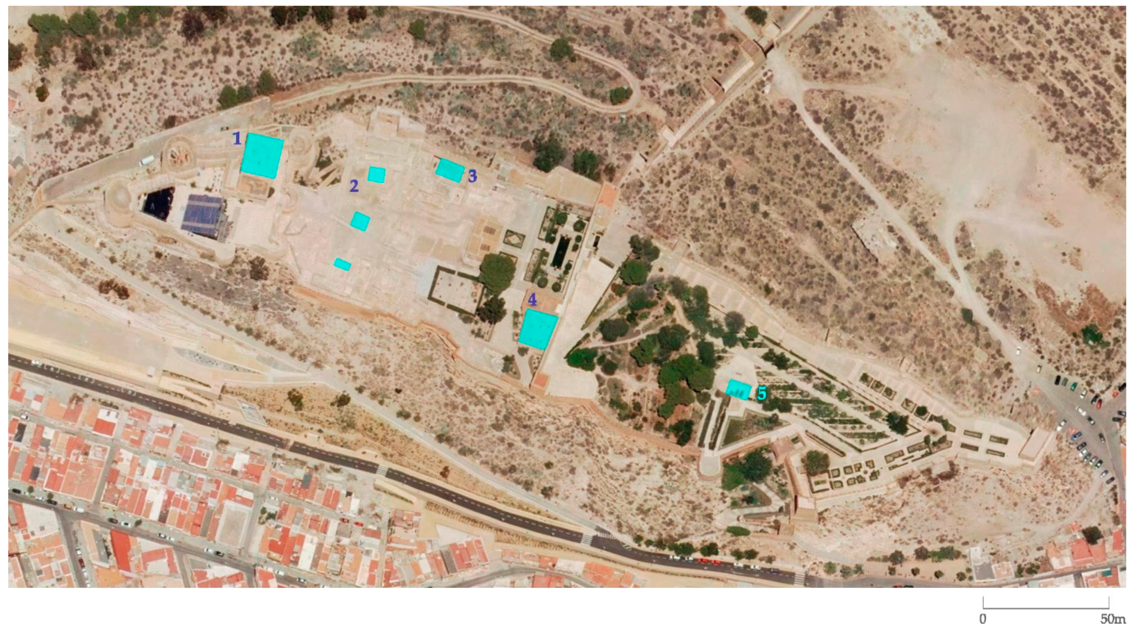
2.1. The Case of the Alhambra as a Summary of Advanced Hydraulic Solutions

The citadel of the Alhambra was the seat of the Nasrid dynasty (1238–1491), although its alcazaba is developed over an earlier fortress (Malpica Cuello 1996, 2002; Martín García et al. 1999). It is situated on the top of the Sabīka Hill (as was referred by the writer Ibn Baṭṭūṭah from Tangier, in the fourteenth century), also known as the Red (al-Ḥamrāʾ) Hill, a place with an excellent strategic position but, on account of its lack of water, with limitations for human settlement. The implementation of a complex and flexible hydraulic system capable of supplying abundant water would allow the development of a medieval palatine city near the Alcazaba of the Alhambra.
The first monarch of the Nasrid dynasty, Muḥammad ʿAbd Allāh ibn al-Aḥmar (r. 1232–1273), must have conceived the walls and general layout of the enclosure. According to Ibn ʿIdarī al-Marrākushī, in 1238, he took water from the river, building a dam and digging out a water channel for this sole purpose, which would ensure the Alhambra’s subsistence and independence (Huici Miranda 1954, p. 125). They looked for a collection point in the Darro River more than 6 km from the Alhambra, so that most of it could be supplied by gravity.
Further to this, Muḥammad V (r. 1362–1391) put the Acequia de los Arquillos (Little Arches Water Channel) into operation in the second half of the fourteenth century, which led to the supply of water to the almunias (from Arabic al-munya, plur. munān, country estates with vegetable gardens) that were situated beyond the reach of the first channelling. The almunias of Los Alijares (Higuera Rodríguez and Morales Delgado 1999, p. 33), Dār al-ʿArūsa (Rubiera Mata 2005, art. VIII, pp. 5–7; Orihuela Uzal 1996, pp. 221–27; Malpica Cuello 2002, pp. 333, 336–37) and Dār al-Wādī (García-Pulido 2016) were built, achieving the occupation and exploitation of the territory surrounding the Alhambra (Figure 2).

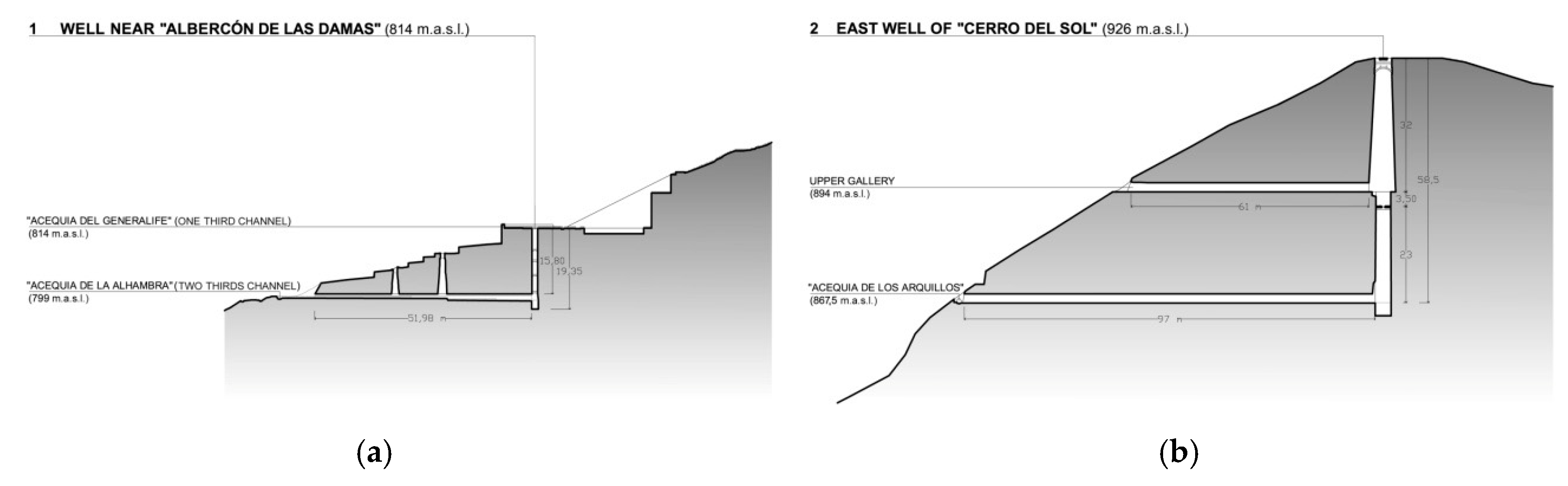
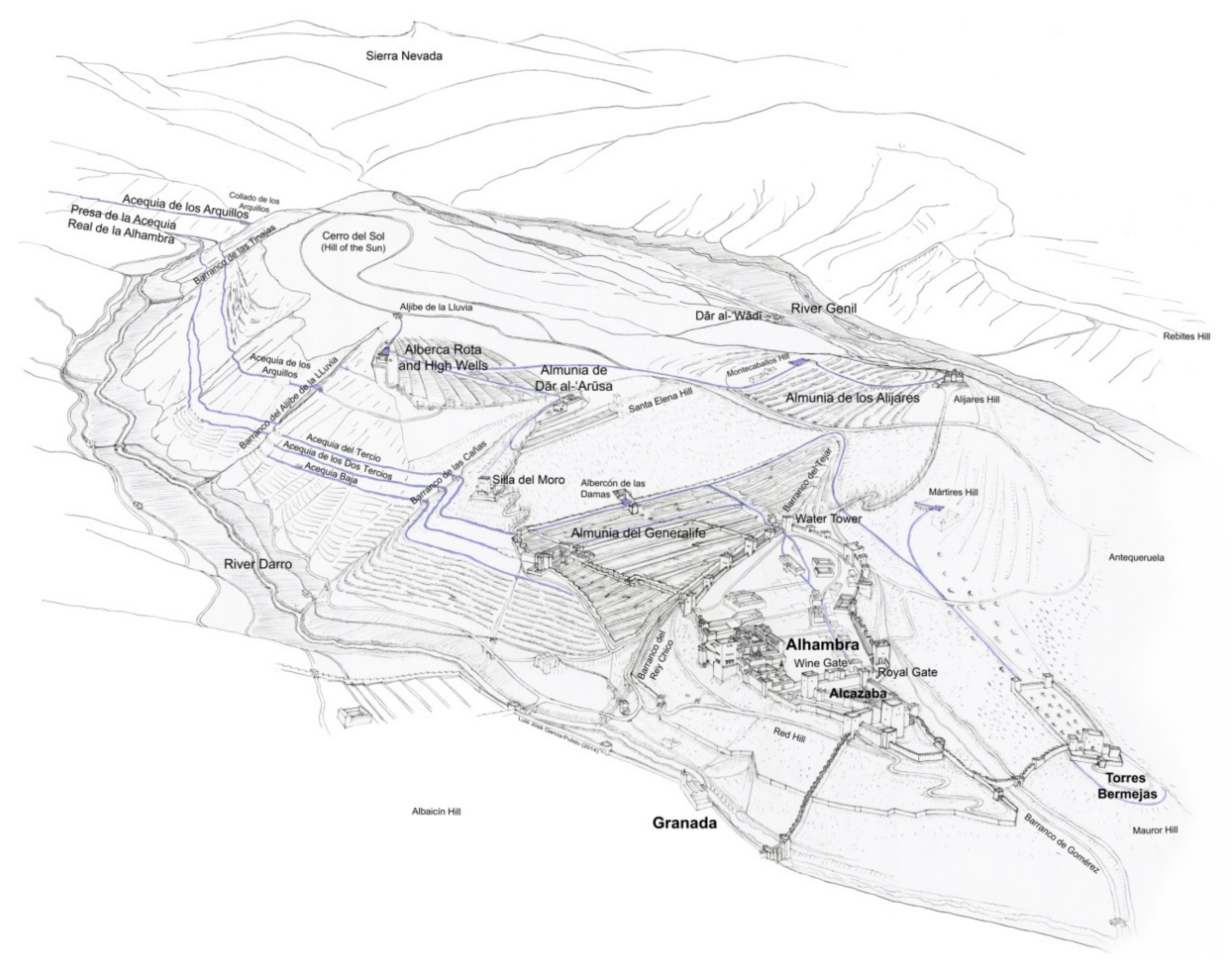
2.1.1. The Royal Water Channel (Acequia Real)

Prior to the works of Muḥammad I for the water supply of the Red Hill, a fortification existed in the area where the Alcazaba of the Alhambra was developed. It had a bath and a big cistern that was supplied by using a fortified wall (coracha) that reached the Darro River from the north wall. Later, in the thirteenth century, the development of a gravitational channelling system for the Alhambra also allowed supply to the aljibe of the Alcazaba (Gómez-Moreno Martínez 1966, p. 16), through the Royal Water Channel.
The source of this channel was on a diversion outlet dam on the Darro River, at 838 m above sea level, although there are other water catchments and medieval hydraulic archaeological remains slightly higher that converge on this spot.
The main water channel entry into the Generalife palace is at 798.50 m above sea level, maintaining a constant slope along its gardens and accomplishing the agricultural supply. However, after crossing 350 metres, it descends abruptly by 10.5 m to the level of its entry into the citadel. This indicates that, when designing the irrigation channel in 1238, extensive areas for cultivation were foreseen on the slope where the Generalife gardens are situated.
When the water channel entered into the Alhambra walls, it initially divided into two branches that later joined together, organising the urban structure of the citadel. An extensive network of different ceramic pipes called atanores in Spanish (from Arabic tannur), enabled the distribution by gravity to all the enclosures of the Alhambra, by means of separators with small flood gates that supplied water to at least six baths, more than eight aljibes, and numerous fountains, albercas, and gardens of the houses and palaces of this citadel.
The extension of the hydraulic system in the second half of the fourteenth century by the creation of the Acequia de los Arquillos entailed the settlement and control of the nearby hills, implementing ingenious elevation systems to overcome the altitude limitations created by these irrigation ditches. One of the most outstanding was the diversion tunnels that, at different levels, fill the reservoirs situated at the bottom of dry wells, in which a waterwheel was generally devised to raise the water to a higher point. Today, this system is usually referred as a reverse qanāt.
In Nasrid times, the intense hydraulic network established in the valley of the Darro river would have enabled an extensive settlement. Although Christian historical sources only refer to the existence of the farmsteads of Beas, Cortes, and Huétor, which were linked to the royal family, traces of other nuclei were preserved downstream along the water channels of the Alhambra, as Arquillos, Solana and Umbría, which would indicate the existence of other royal properties in this area.
Following the conquest of Granada by the Catholic Monarchs in 1492, they realized the mastery achieved by Nasrid people with respect to the use and management of water. Therefore, an immediate provision for the maintenance and functioning of the hydraulic systems was made, which enabled the survival of the Royal Water Channel up to the present day.

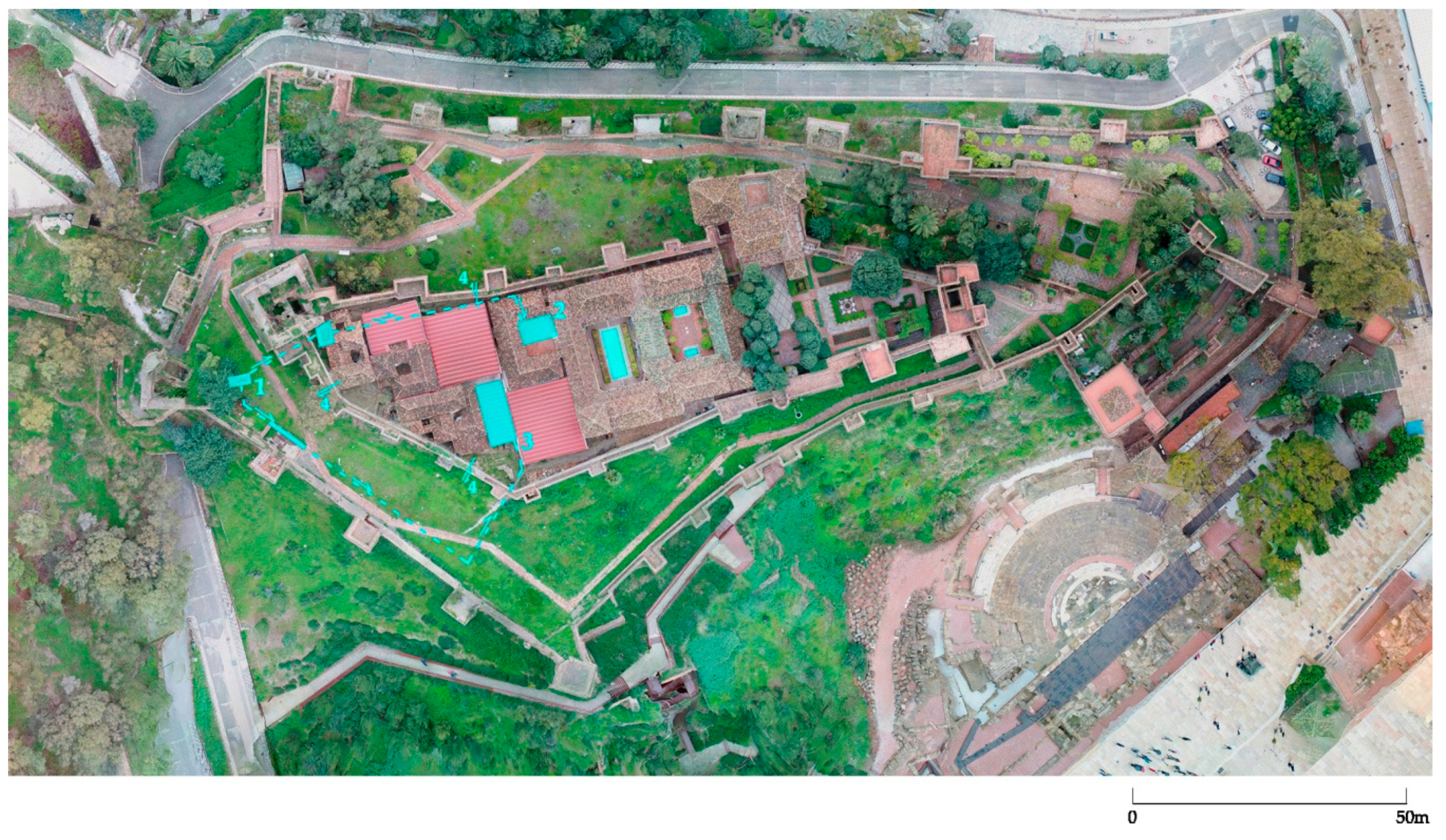
2.1.2. Water Elevation from the Royal Water Channel to the Alcazaba of the Alhambra

The Alcazaba of the Alhambra is separated from the Sabīka Hill by a ravine. It is situated at 778 m above sea level, 6 m above the beginning of the Royal Street of the Alhambra at the Puerta del Vino (Wine Gate). Water supply in these cases was usually solved either by using an aqueduct or a syphon as, for instance, was used in the last section of the canalization that supplied the Alijares Palace. In the Alcazaba, a syphon has been in operation since the nineteenth century, having replaced a unique device that had been functioning up to the end of the eighteenth century, after the Christian conquest, being carefully kept up as it was, even though its operating principle was not understood.
Confusing description of this device was mentioned in the second half of the eighteenth century (Velázquez de Echeverría 1764, vol. I, pp. 62–63). This system would have replaced an earlier one, destroyed with the demolition of the Puerta Real (Royal Gate) in the sixteenth century. The description shows the misunderstanding of the principle of physics that explained how it worked. It indicates the existence of a vertical tube with a vent at the top, which acted as an elevation duct to take water up to the level of the walls.
At the beginning of the twentieth century, it was demonstrated that such a water elevation procedure was feasible (Cáceres 1914, vol. IX, pp. 77–82; Rubio Gandía et al. 2002, pp. 279–82), through an experiment based on the idea of setting a suction tube within a descending pipe, which, after emptying into a sealed space, would become a propulsion tube. It was able to raise a fraction of the water that entered the device to a height almost triple the distance between the entrance funnel and the sealed lower receptacle. It showed that the 6-metre difference in height that existed between the Alcazaba and the Royal Gate could have been overcome if the original device had had a 2-metre load height. The interpretation of Cáceres’ description implies the use of something similar to a Vortex Tube (García-Pulido 2016, pp. 15–18).
This type of device could have been used in more Andalusian fortresses, like the Alcazaba of Antequera, as explained below.

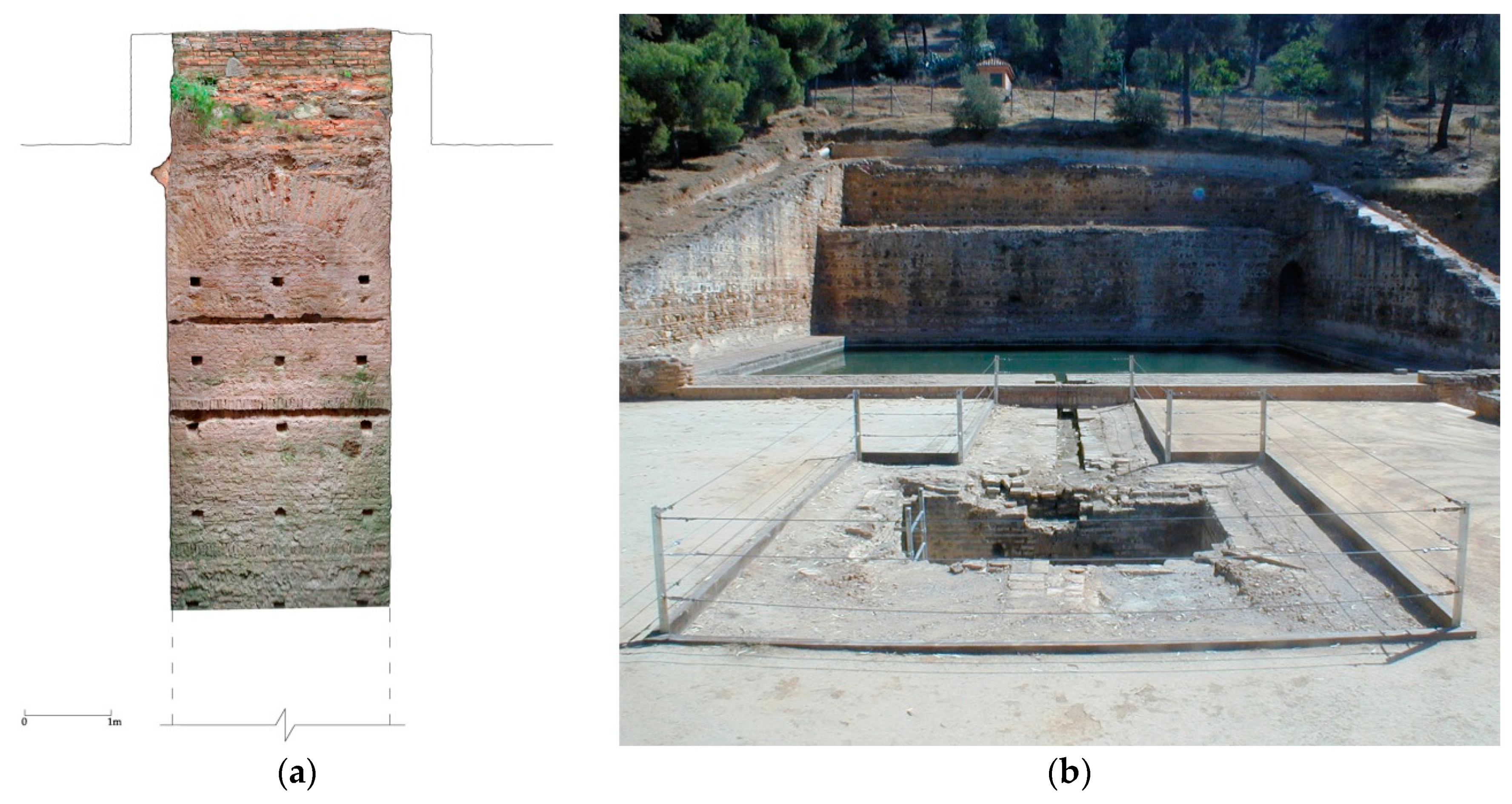
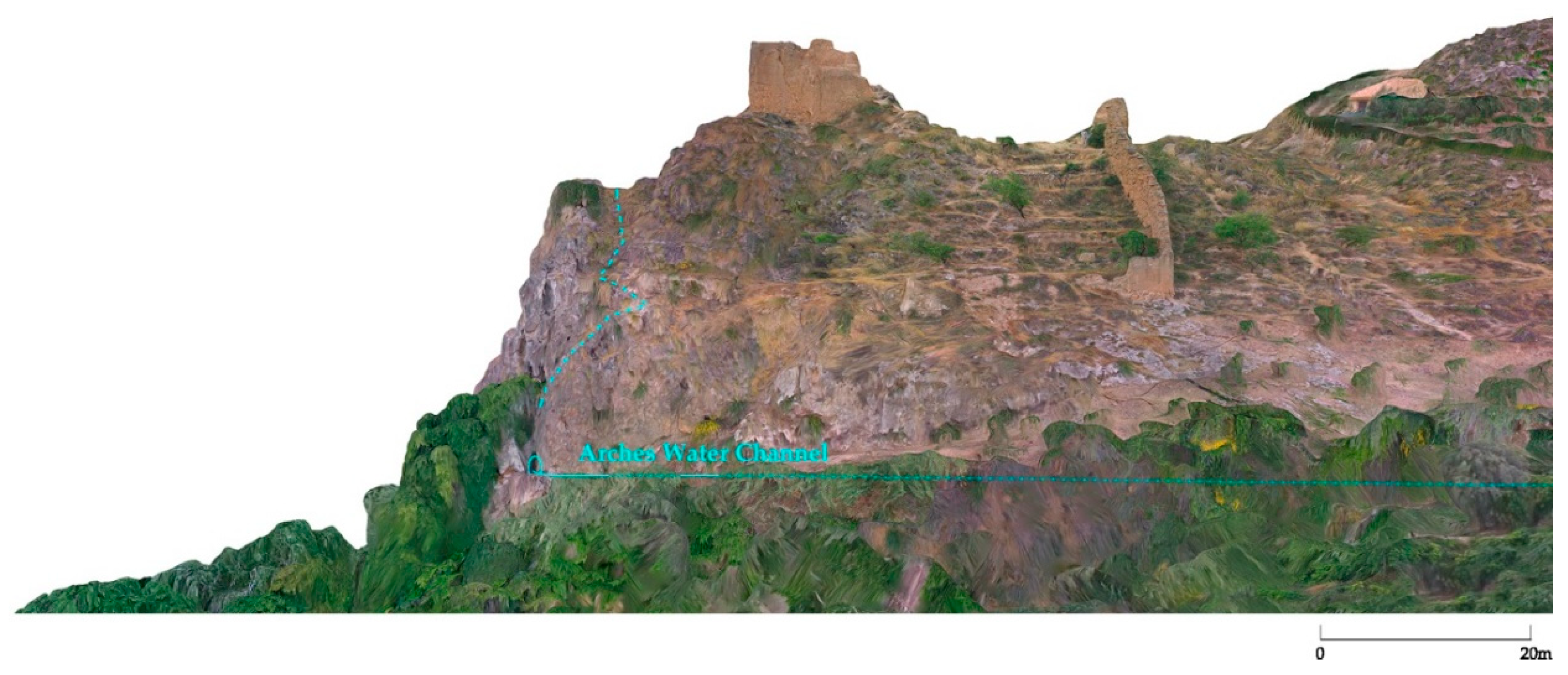
2.1.3. Use of Reverse Qanāts Associated with the Royal Water Channels

This is one of the systems used in the Alhambra and other important fortresses to break the altitude limitations of a water channel. The use of the term qanāt alludes to the fact that the layout of the required elements (a horizontal gallery, airing shafts (where they exist), and a main well) has a similar appearance to that of a qanāt, although its operating principle is completely different. It is a well that does not reach down to the water table, and therefore requires a horizontal underground gallery with slope downward to the interior to bring the water in from an external source. The existence of a deposit at the bottom of the well indicates that a certain amount of liquid could be accumulated; this water would have to be brought to the surface by a waterwheel. This was an expensive technique, both for construction and for maintenance and conservation.
In the Alhambra, the first known reverse qanāt was the one put in place to supply the Albercón de las Damas from the Royal Water Channel (Figure 3a). Some scholars argue that it must have been installed in the mid or first half of the fourteenth century when major works were carried out on the nearby Generalife (Malpica Cuello 1991, pp. 65–101; Malpica Cuello 1996, p. 414; Bermúdez López 1992, pp. 153–61; Salmerón Escobar 2006). Years later, it would be replaced by a second branch channel of the Royal Water Channel, called the One-Third or Generalife Water Channel, which had a higher level and reached the pond directly.
The major example of this technique in the Alhambra territory is the East Well of the Alberca Rota complex. It is divided into two levels, each with a horizontal gallery and underground deposits built of brick (Gómez-Moreno Martínez 1889, pp. 109–110; García-Pulido et al. 2011, pp. 828–31) (Figure 3b).
During the construction works carried out by Muḥammad V, the water supply was via the Little Arches Water Channel and the Royal Water Channel too. From the first one, the water penetrated into the hill by an inferior gallery 105 m long, by means of a conduction of ceramic piping as far as a small inner deposit made of brick. A waterwheel with buckets was installed in the upper section of the well to elevate water 59 m deep. A similar device had worked rising water from the Royal Water Channel to the entrance of the previous gallery, by means of another well 63 m deep linked to a lower tunnel 126 m long (García-Pulido forthcoming).
Later on, water catchment from the upper channel was abandoned in order to excavate a higher gallery 61 m long, situated at 32 m from the surface. Inside it, a narrow brick channel was laid, pouring the water into a small deposit suspended beneath the well shaft. The hydraulic supply could have been obtained from some mine that existed in the nearby ravine, whose water table had been exploited in various parts of the route. Particularly important was the catchment at the headwaters, which continues to flow into the Aljibe de la Lluvia (Cistern of the Rain).
The last moment of functioning was characterized by its residual use and the low output of the hydraulic system. The small deposit in the higher gallery was eliminated by means of an oval-shaped perforation made in the bottom, which made it possible to recover the water stored in the lower deposit; presumably, this still flowed through the Little Arches Water Channel or was taken out of another mine made in the ravine at a lower level. The water had to be raised to the surface by means of two manoeuvres, which meant that a waterwheel could not be used in the upper section of the well.
In the palace of Dār al-ʿArūsa there is a well depth of 6.60 m, and underneath it, there is a brick deposit 1.36 m wide and 3.6 m long. In the upper left part of the north-eastern face, 1.24 m up from the base of the well there are the remains of an earthenware pipe, 9.50 cm in diameter. Its level matches that of a channel coming from the Alberca Rota complex. In this case, the subterranean horizontal gallery of the reverse qanāt would have comprised this ceramic pipe.

2.2. Alcazaba of Malaga—Deep Well Dug through the Bedrock to the Water Table and Extraction by Means of a Waterwheel

The Alcazaba of Malaga is very close to the port of Malaga, taking advantage of a promontory situated to the southwest of the hill where the Gibralfaro Castle was built, between 30 and 50 m above sea level. The first constructions of this alcazaba seem to date back to the eleventh century, although during the thirteenth and fourteenth century, various reconstructions and extensions were carried out, which led in part to the shape of the citadel of present times. It is a palatial city and fortified enclosure inside the defensive systems of the city. It measures about 200 m in the west–east direction to a maximum of about 100 m from north to south (1.26 ha), conforming to the unevenness of the terrain.
In its northern part, there is a well in the enclosure that is between both lines of the walls, called Pozo Airón (Airon Well), at about 45 m above sea level. It is excavated in the rock, reaching a depth of 30 m at the present time, although maybe deeper until it reached a natural spring. There would have been a waterwheel to raise the water (Carranza Sell 2010, p. 121) (Figure 4a).
The well curb is a rectangle of 2.55 m × 1.00 m. Its constructive technique, similar to that one on the Albercón de las Damas at the Generalife (Figure 4b), allows us to identify the process followed in the building of the well (Figure 4a). Internally, it is covered with brick arranged in alternating rows, although it was plastered and still has some wedge-shaped incisions, very common in coatings of towers and hydraulic structures from Nasrid times. In the upper part, under the curb, there are low arches with a width of two feet. These structural elements show that they were built at the beginning of the excavation to support the curb. Finally, they were completed with brick rows on the lateral closing walls, arranged from the bottom of the well to the top, as it is shown by the hollows of the squared timber to brace the profiles of the excavation, in groups of three or by means of entire slats.
The well is located between the so-called Torre del Homenaje and the exterior wall, to the north of the Housing District, at the highest end of the upper enclosure of the alcazaba. This neighbourhood, considered a good example of the advanced urbanism of the eleventh century, was excavated by Leopoldo Torres Balbás in the first half of the twentieth century. A series of drains were found crossing the wall, two of which are situated near the well. The water inlet must, therefore, have occurred in the upper part, close to the ḥammām, next to which there is an aljibe that still accumulates water (Figure 5). This neighbourhood, the associated baths, the cistern and the palaces would have been supplied through this well (Carranza Sell 2010, p. 63).

2.3. Alcazabas of Almería and Baza—Channelling under the Hill and Elevation from a Tower by Means of a Well with a Waterwheel (Reverse Qanāt)
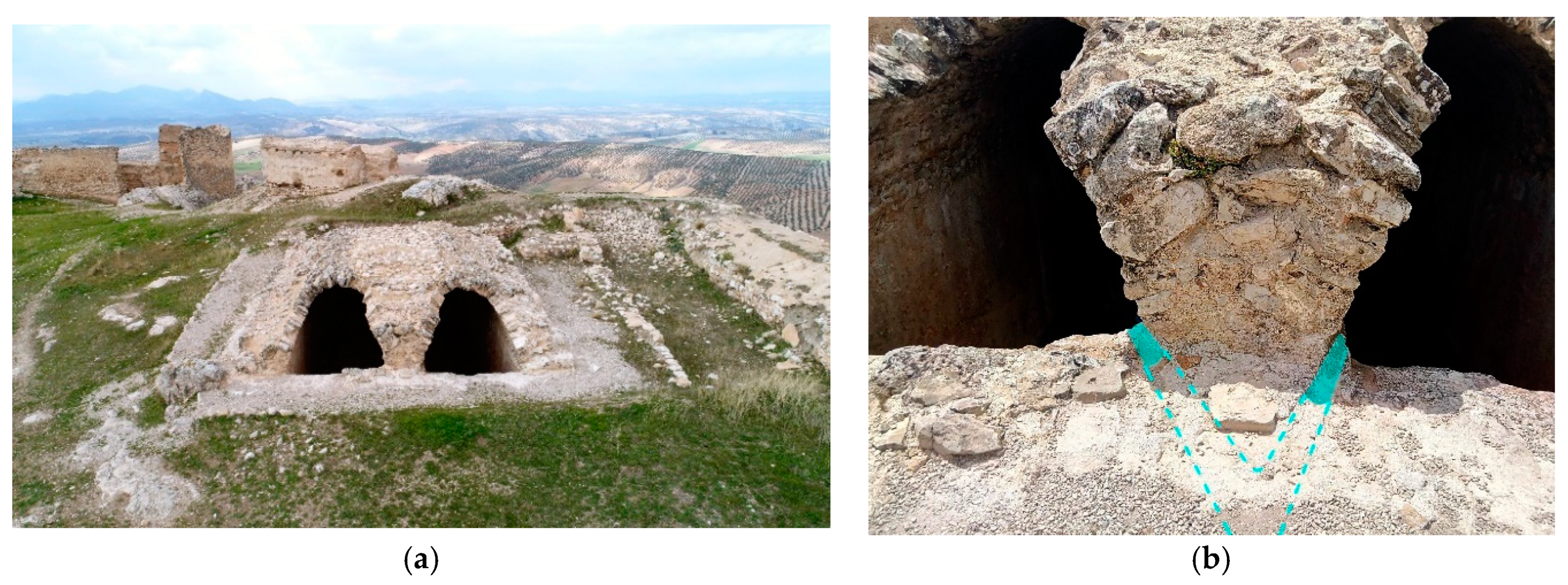
Almeria (al-Mariyya) was one of the main cities of al-Andalus, situated in the south-eastern end of the Iberian Peninsula. The port of Bajjāna (Pechina, an inland city situated 6 km from the Mediterranean Sea, on the left shore of the Andax River) was developed in this spot during the ninth century. Between 858 and 859, a watchtower (al-Mariyya) was built, as well as some defensive enclosures (maharis) to defend against Norman raids. In 915, there was already a citadel (Ibn Hayyan 1981, p. 85). This first Emiral enclosure was built on the highest part of the hill, and it would possibly be smaller than the final alcazaba that was developed afterwards (Gurriarán Daza forthcoming).
Shortly after the attack by the Fatimid caliph al-Muʿizz in 955–956, ʿAbd al-Raḥmān III and his son al-Ḥakam II restored and extended the citadel itself. They also walled the growing settlement of the former port of Pechina and transformed it into the city of Almeria (Lévi-Provençal 1957, p. 373).
The alcazaba (2.17 ha) is located on an elongated hill of 500 m × 100 m and more than 80 m above sea level, parallel to the Gulf of Almeria, in the lower parts of the hill of La Hoya. This promontory was levelled, it was divided into three enclosures following the topography and the lower one was also walled.
According to al-ʿUdrī from Almeria, in Taifa times (eleventh century) the leaders of the city built a channel for water supply. The authorities promoted hydraulic works which had a prestigious character (Navarro Palazón and Jiménez Castillo 1995, p. 402). The main Mosque of Almeria had its own supply in 1066 and a hydraulic shunt was derived from the water channel to behind the alcazaba. This new ditch flowed underground until it reached the well dug in the north of the citadel. A water mill was built on the well, to raise the water to the gardens of the palace (Lirola Delgado 2005, pp. 27–31).
Water was raised to the alcazaba by means of a well linked to the Noria del Viento Tower, situated in the northern walls of the upper enclosure (Gurriarán Daza forthcoming). This tower could be the one referred by the historical sources as the Tower of the Well of the alcazaba (Bury al-Biʾr), that was destroyed by Jayran during the siege of 1014. It was rebuilt by the Catholic Monarchs after the conquest of Almeria, on another previous rammed-earth tower, whose remains can still be seen at its foundation. This tower still has a well inside it, with a preserved depth of 35 m. It is situated at the highest point of the fortress, where it could supply the whole fortified enclosure.
The alcazaba palace (was built 100 m to the southeast of this point with a cross-shaped patio and three small ponds (one in the centre and two next to the porticos), in order to irrigate its inner gardens and those that could be situated in the surroundings of the palace.
The central enclosure would be defined by the southern wall of this palace and the Muro de la Vela towards the middle of the alcazaba, which separates it from the lower terrace. On this central terrace, the Baño de la Tropa was built, attached to the northern wall, while on the southern half of the Muro de la Vela and on the southern side of the main mosque of the alcazaba, a large cistern with five naves was built. It has been dated from the Umayyad Caliphate times (tenth century), due to the constructive patterns in its vault. The water supply of this aljibe comes from the rain, but it could also have been linked with the Tower of the Well.
The lower enclosure of the citadel has another storage system that was unearthed a few decades ago, supplying the surrounding neighbourhood. During the first half of the eleventh century, an aljibe with three naves and a water wheel was built. A fountain with a bowl was added in the first half of the twelfth century and, finally, a decanting basin that collected rainwater and drained it into the cistern (Cara Barrionuevo 2005, p. 115) (Figure 6).
The Noria del Viento Tower is situated about 85 m above sea level, and the main mosque of Almeria was around 70 m lower. If the connection had been made after the channel that reached the Aljama, it would have flowed approximately 500 m underground, until reaching the vertical of the well. Al-ʿUdrī wrote that the connection would have occurred by means of a derivation from the main water channel, perhaps after having reached the aljibe with three naves located near the Pechina Gate, around 23 m above sea level. From this point, it could have reached the southern slopes of the hill of the citadel about 250 m from the base of the well. An underground gallery of this length must be opened underneath the alcazaba and then be elevated about 62 m. A similar system has recently been excavated in the citadel of Salobreña (Navarro Palazón et al. 2018).

Alcazaba of Baza

The city of Baza is located on the western edge of the basin of the same name, which is one of the depressions of the north-eastern area of the province of Granada. The urban settlement is laid out on a gentle slope towards the east, between 870 and 820 m above sea level. The Hill of the Alcazaba stands out in this relief, at 860 m above sea level, with an elliptical shape arranged on a north–south axis.
The population along with its suburbs would have occupied over 23 ha during the Nasrid period. The city centre itself (the Almedina district, from Arabic al-madīna) would occupy about 3.24 ha and the alcazaba only 0.87 ha. To the west, the suburb of Algedid (from Arabic al-Jadīda, the New) was finally developed, and to the north, the suburb of Churra.
The citadel was open to the south, although at the moment it is surrounded in its entire perimeter by the urban development of the twentieth century. From the south end came the Caz or Acequia Mayor (main water channel), which was fed mainly from the Prado de las Siete Fuentes (The Meadow of the Seven Springs), located about 4 km south of the city, although it also received water supply by means of a divergence of the San Juan or Morayja Fountain.
At the height of 860 m above sea level, there are the remains of an extremely damaged tower, located at less than 10 m of difference from the passage of this water channel and about 5 m away from it. This opens the possibility of a system from inside the tower to elevate water from the channel to the citadel (Caballero Cobos forthcoming).

2.4. Alcazabas of Antequera and Ronda. Water Elevation without Energy Input

The description of the remains of the artefact that enables the ascent of water to the Alcazaba of the Alhambra, along with the experiments carried out in the twentieth century, allows us to consider its presence in other citadels of the Nasrid kingdom. Such could be the case at the Alcazaba of Antequera, as described above in the Alhambra.

2.4.1. Alcazaba of Antequera

Located on a hill on the left bank of the Villa River and to the south of the Plains of Antequera, the alcazaba (1.55 ha) is in a dominant position on the plateau where the present town of Antequera is situated. The hill is entirely conditioned by the river bed. It flows about 40 m from the town walls and generates a strong fall towards the southeast, although the topography has undergone many alterations due to the urban development of the eastern slope of the alcazaba.
It has two well-defined enclosures; one known as the Christian alcázar is subdivided into two terraces. The second space surrounds the previous one, marking a third terrace that ascends to the south to the level of 578 m above sea level. It descends progressively towards the north to 562 m above sea level (Romero Pérez et al. 2007, pp. 17–19; Melero García and Romero Pérez forthcoming). In Nasrid times, there was also a little opening or gate with direct access to the river.
There are remains of several hydraulic infrastructures linked to this hill. On one side, the vegetable gardens located on the north part of the city were irrigated at least until the end of the fifteenth century to the public water channel called Valedalanes.
Additionally, a hydraulic account of the city written by Sancho de Toledo in 1545 (Escalante Jiménez 2008) refers to two infrastructures that supplied water to Antequera. One of them is an underground mine discovered in 1995 next to the Torre del Agua (Water Tower) (Romero Pérez 2002, pp. 164–68). Its integration with the city walls indicates that it had a precursor from Nasrid times, although in modern times, it led the water to the new city outside the walls. Both the Valdealanes water channel and this mine are intercepted by the Torre del Agua, which should have allowed the raising of water manually or by means of a water wheel in order to supply the city inside the walls.
The Aqueduct of the Arches is the other infrastructure providing water in the mid-sixteenth century. It collects water at the foot of the Chimeneas mountain range, more than 4 km to the south of Antequera. It flows through the pass of Las Ánimas and the surroundings of the Torre del Hacho. There were continuous diachronic changes in its route until it was abandoned in the late nineteenth or early twentieth century, when it was replaced by the current Little Arches Aqueduct.
The objective of this channelling was to connect with the city through two points in the walls. One of them was not referred by Sancho de Toledo, but other scholars from the seventeenth century did mention it (Cobos Rodríguez 2014, p. 34). It consists of a direct channelling by means of a siphon of ceramic pipes from the Plaza del Portichuelo to the parade ground (Patio de Armas) of the fortress, crossing the barbican and the wall between the two main towers, thus reaching the highest point of the alcazaba. The other water supply could have been achieved by the Tower of the street of Herradores, next to the northern corner of the citadel. There, a similar elevation system to that of the Alcazaba of the Alhambra could have been established. Vertical ceramic pipes of different sizes could have raised water to at least 8 m from the present level 552 m above sea level outside the town. This system of ducts, water arcs in the high and low parts of the tower, different openings, and other hydraulic “secrets”, were related by Sancho de Toledo in 1545.
The most ancient evidence from the aqueduct seems to be part of a qanāt with wells linked to each other, which open on to the limestone terrain of an area that could correspond to the meadow of Duranguillo (Melero García and Romero Pérez forthcoming). These wells do not appear in Sancho de Toledo’s detailed description of each of the water arcs in use in 1545. They are considered to have been from the Islamic period, probably reusing another from Roman times.
Inside the precincts of the citadel, there exist cisterns from Antiquity, as well as little ponds dug in the limestone rock and covered with mortar, with a difficult dating. From the Andalusian times, there existed at least two aljibes with different chronology. They must have stored rainwater, although it is possible that they were supplied by some of these distribution branches of the Aqueduct of the Arches (Melero García and Romero Pérez forthcoming). One of them, located on the first terrace, dates from the eleventh or twelfth century, although it probably lasted up until the thirteenth century and could have been linked to the dwellings of the elite of the citadel. In the fourteenth century, the great cistern measuring 6.20 m × 4.10 m was built on the second terrace next to the mosque of the Alcazaba of Antequera.

2.4.2. Alcazaba of Ronda

The historical development of Ronda until the end of the Middle Ages is limited to the hill where the citadel is located and its foothills, mainly on the eastern side (Castaño Aguilar et al. 2005; Castaño Aguilar forthcoming). As with the previous ones, the Alcazaba of Ronda (1.09 ha) was also composed of a double walled enclosure: the main one, located at the highest part, and a lower one as a barbican. To the west, the rampart of the citadel overlapped with the city walls.
This is a relatively isolated flat hill that has a clearly dominant position over its surroundings, which became detached from a high plateau due to the erosive effect of the Guadalevín River that generates steep slopes to the west and east.
The need for water supply to this plateau was solved in the third century AD by means of an aqueduct (de Hoyos et al. 2004). Due to its location, a large cistern that exists in the convent of Santa Isabel de los Ángeles could be related to this Roman aqueduct (Castaño Aguilar forthcoming).
At the beginning of the twentieth century, there was the general idea that the water of medieval Ronda could not come from aqueducts because of its size and design (Pérez de Guzmán y Gallo 1910, p. 41). The most striking hydraulic element preserved in this city, the cave called Mina de la casa del Rey Moro, has contributed to this fact. It was a defensive and secure underground way to descend for water to the river level, protected by itself and by means of a tower that is still partly visible next to the Old Bridge (Pavón Maldonado 1990).
Among the large diaphragm arches inside this “mine” runs an intricate staircase with rooms, landings, and cantilevers whose function was not only related to the extraction of water and its maximum use, but also with its defence, both external and internal (De Hoyos and Aguilar 2000, pp. 379–80). As a hydraulic system, it was not supplied directly by the river, but by the water table. It is possible that water was elevated with a waterwheel since, at the bottom, structures were found that could have belonged to a cistern or wells (Pérez de Guzmán y Gallo 1910, pp. 46–47).
Within the enclosure of the alcazaba, we know of the existence of two aljibes (Miró Domínguez 1987, p. 96). Some of them were already known in other buildings, such as the Main Church (former aljama). Recently another one was discovered in the Plaza Duquesa de Parcent. Due to its size and storage capacity, it was considered a public cistern. In addition, all the houses of the neighbourhood of La Ciudad have their own or shared one. Among them, we highlight the Casa del Gigante, which has the only accessible cistern with a medieval chronology since it occupies the entire southern corridor of this dwelling. Possibly, the system was completed at the top of the city with a reservoir or cistern from which water would be distributed to the aljibes.
Recently, the director of the Museum of Ronda has discovered a perforation in the western barbican of the citadel, the purpose of which is to hold a water pipe (Castaño Aguilar forthcoming). This evidence could support the existence of a medieval syphon in the last section of this infrastructure. On the other hand, local scholars also described at the end of the nineteenth century the existence of lead pipes linked to this system (Rivera Valenzuela 1873, p. 50).
Until now, it has been assumed that the hydraulic supply of Ronda relied on the mine next to the River Guadalevín, but it is clear that the elevation of water from the river level to the network of reservoirs in the medina would have been a very costly task, especially to the alcazaba, which was in the opposite sector of the city.
The traces which were found of a system of pipes crossing the sections of the medieval wall in the immediate vicinity of the place occupied by the citadel would give credibility to the words of Ibn al-Khatib in the fourteenth century, referring to the existence of aqueducts that take water to the city (Castaño Aguilar forthcoming). These could be related to the Aqueduct of the Fountain of the Sand, which sets out from the left bank of the Arroyo de las Culebras and would reach the structures existing in the Predicatorio, in front of the alcazaba. From this point, the head of a syphon could have allowed water to be raised to the plateau of Ronda (Sierra de Cózar 1990).

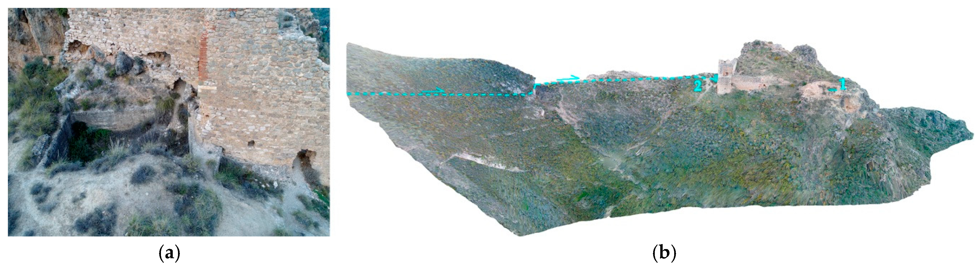
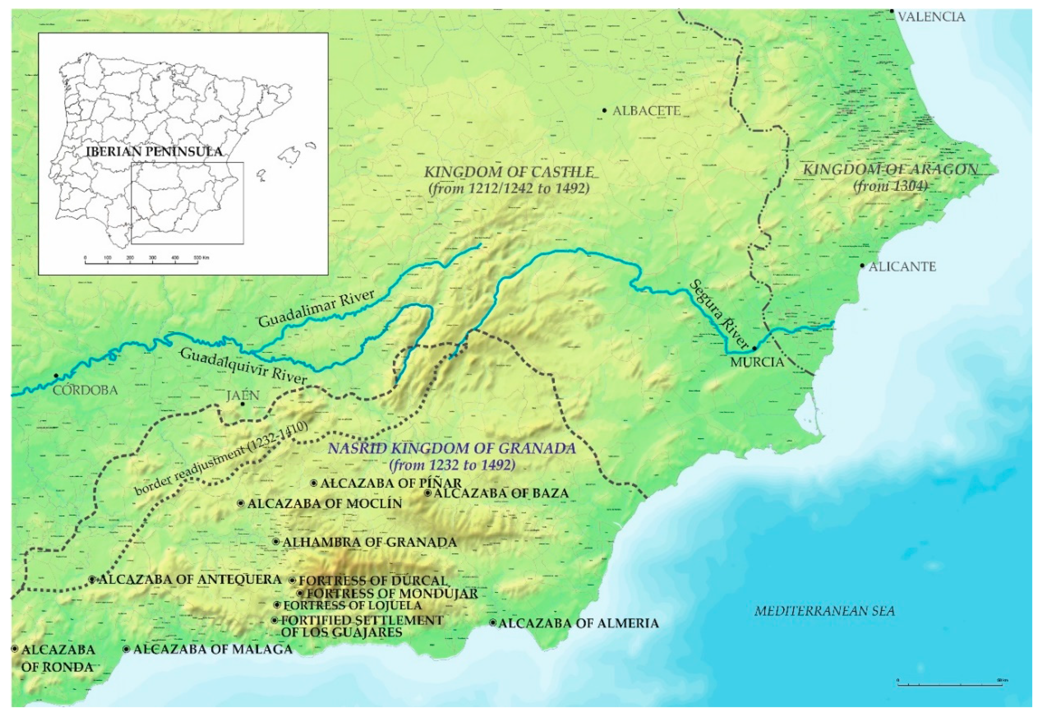
2.5. Mondújar Fortress and the Fortified Settlement of Los Guájares—Water Channel Gravity-Driven through Topography

In some cases, the topography itself enables water supply by gravity from levels higher than the location of an alcazaba, without the need to resort to any other facilities than minimum levelling systems or the introduction of small syphons.

2.5.1. Mondújar Fortress

Mondújar Fortress is located in the Lecrín Valley (Granada), built on the rocky summit of the last hill of a mountain range of the Fuentezuela ravine and another one known as the ancient Sierra path, a route from Mondújar to the southwest foothills of Sierra Nevada. The walls, some towers, and two cisterns are the only remaining parts of the castle (0.37 ha).
Written sources refer to its construction during the Nasrid kingdom. It might have been one of the strongholds built by Yūsuf I or Muḥammad V, as a part of its plan to refortify some areas of the Nasrid kingdom from the threat of the Castilians (Molina Fajardo 2007). Later, this fortress was the scene of the resistance towards the Mudéjar uprising in 1499, being the only fortress to remain in the hands of Castile, under the command of Guiomar de Acuña, wife of Pedro de Zafra. This fact shows the Castilian occupation and possible modifications of the fortress.
It is only accessible from the slope towards the northeast, and from the chain of hills that precede its position. These hills descend gradually from 1009 to 870 m above sea level, where the fortress is situated. This is reached through a pass in the higher mountains where there is a route that leads to the fortress.
Close to the main gate, there is a cistern that measures 9.25 m × 4.60 m, which retains the traces of a barrel vault that has now completely disappeared. This aljibe is located outside the walled enclosure and its layout is not aligned with the walls, which implies that the cistern could have been built prior to the walls. We should emphasize the existence of a vaulted passage in its northwest corner, connecting this water tank with the walled enclosure. This passage could be a way to manual access to water.
This cistern seems to be connected to the track that runs along the crest of the hill from the east and reaches the entrance of the fortress (Figure 7a). Along this hill, there is a series of traces that follow the isolines of the landform. One of them reaches a trough dammed by a masonry wall. This place could have been used to collect the runoff water from the adjacent slopes or even as a small dam of the old course of a river.
The hypothesis that water could be supplied by gravity through a water channel from the opposite hill to the fortress can be considered. Once here, a small aqueduct would save the depression that precedes the hill and maintain the level of the canal, which would reach the cistern which is outside the walled enclosure (Figure 7b).
Inside the fortified enclosure, there is another rectangular cistern with only one nave, attached to the northeast stretch of the wall, smaller than the outside one. It preserves the starting point of a semicircular vault in one corner, and there are two small holes on the wall facing the interior of the fortress. This aljibe could have been filled through these holes from the water collected inside the fortresses.

2.5.2. The Fortified Settlement of Los Guájares

The Fortified Settlement of Los Guájares is a walled enclosure (0.29 ha) occupied by a dense network of domestic buildings of a rural community (García Porras 2009, p. 1052), located on a hill defined by the deep ravines of Rendite and the course of the Toba River. The archaeological works carried out since the 1980s, focused on the settlement and its surroundings, as well as studies of the ceramic remains discovered, suggest that it was suddenly abandoned at the end of the thirteenth century or at the beginning of the fourteenth century (Barceló i Perelló et al. 1987, p. 366). There is evidence that the settlement continued to maintain a strong defensive identity, and may have had occasional reoccupation during the Mudéjar uprisings until the sixteenth century (García Porras 2009, p. 1053).
The hill is not an isolated elevation, but the end of a mountain chain that descends from Cerro del Palinar, at 914 m above sea level, in the foothills of Sierra del Chaparral. From this hill, a descendant trace can be followed until it ends at 405 m above sea level from the pass after the fortified settlement, where important hydraulic elements remain: a small water tank and a rammed-earth wall, 24 m long and almost 2 m high and aligned with the track. It preserves the imprints of a circular pipe in its upper part. Its layout disappears about 34 m before the entrance to the settlement, where the ground rises. Although it is difficult to reconstruct the route that it could have followed from this point with precision, next to the southeast corner of the settlement, several openings in the wall have been conserved that could show the passage of a pipe along the walled enclosure. The water would reach the interior cistern by gravity from this point, following the wall (Figure 8a).
For all these reasons, the water could be taken at some point in the hills or in the ravines west of the fortified enclosure, possibly from a spring or from a run-off water collection system. The channel would have been adapted to save the ridge prior the settlement, communicating the preserved structures to the alignment aqueduct as the venter of a syphon that would maintain the difference from ground level up to about 10 m (Figure 8b).
It should be noted that, on the northern slope, next to the remains of the water tank and the aqueduct, a system of irrigated terraces of Islamic tradition is preserved. They were supplied at first by a fountain and, later on, by an irrigation channel (García Porras 1995, p. 247; Barceló i Perelló et al. 1987).

2.6. Lojuela and Dúrcal Fortresses—Water Collection from a Lower Channel through a Protected Passage (Coracha) or a Mine

Sometimes there are remains of defensive paths from the fortress down to a river, or even passages that use natural cavities in the rock, which act as natural ways of defence. This old system, reported in the first century BC fortress of Masada for example, appears in several alcazabas already described, such as the Alhambra, or in the medinas of Antequera and Ronda. They can be accompanied by other more complex systems whenever a greater flow of water is needed.
However, in some cases, this infrastructure is the only one preserved in relation to the provision of water from a point outside the fortress itself.

2.6.1. Lojuela Fortress

This is located on a hill that rises on the left bank of the Dúrcal River, in the Lecrín Valley. There are still remains of a large stretch of the eastern wall, part of the northern wall, and the foundation of a tower at the highest point (0.21 ha). The west side is protected by the strong drop towards the Dúrcal river-bed. It is a small-sized fortress that could be a hisn, dating back to the Emirate of Cordoba (eighth–tenth century) (Malpica Cuello 1996). It could be associated with the alquería of Loxuela, which was developed in the surroundings in Nasrid times.
The hill on which it is situated lies at the end of a slope that descends from the Lomas de la Manteca, a plain that extends between the southwest foothills of Sierra Nevada and the Dúrcal River. This channel and a ravine parallel to the Barranco de la Hojuela define the hill, creating a deep slope so that the northern area is the only access point to the fortified enclosure. The source of the river is about 60 m below the level at which the castle is situated (590 m above sea level).
Among the remains of this castle, there is no hydraulic infrastructure other than a possible cistern inside the masonry base of the tower that remains standing (Martín García et al. 1999, p. 296). However, this settlement must have had another water supply system.
It is thought by the local population that there is a passage that communicates the base of the tower with an underground gallery towards the river. This could be a way to take water either from the river or from an intermediate channel (Padilla Mellado and Espinar Moreno 2007). As a matter of fact, a natural fissure can be seen to the east of the tower, which generates a natural trench to descend to the Acequia de los Arcos (Arches Water Channel), which flows at a level of about 40 m lower down (Figure 9).

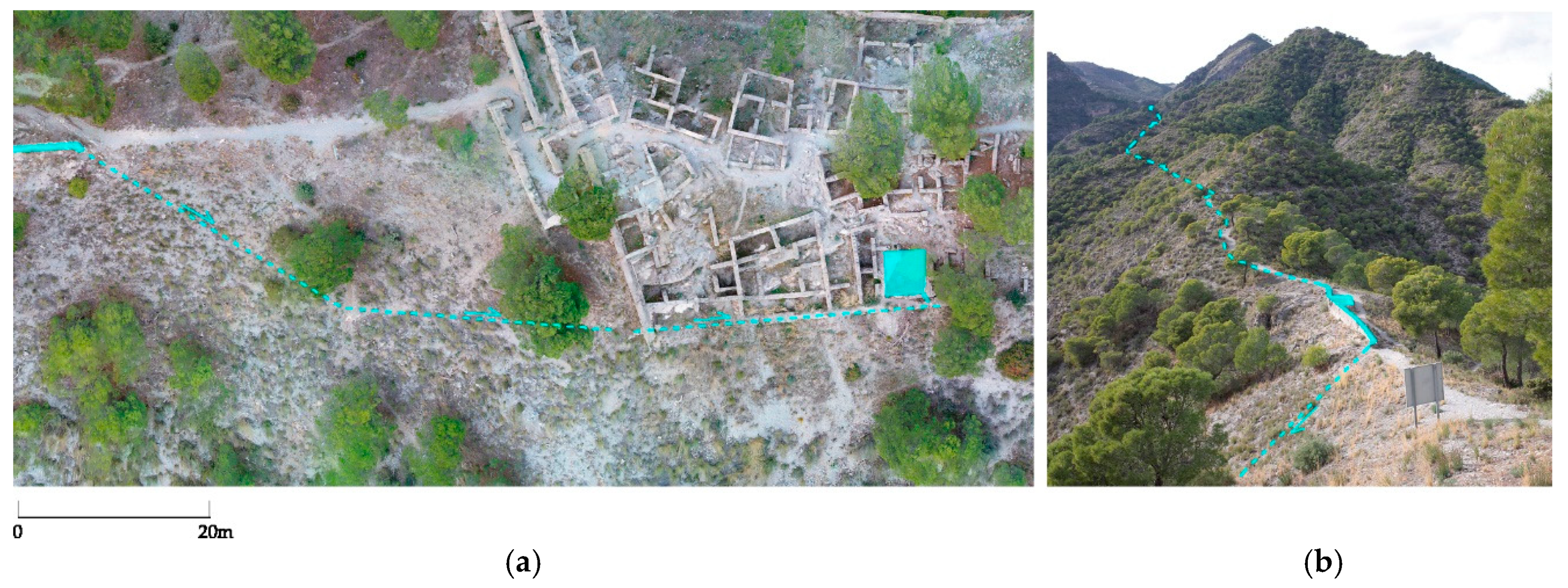
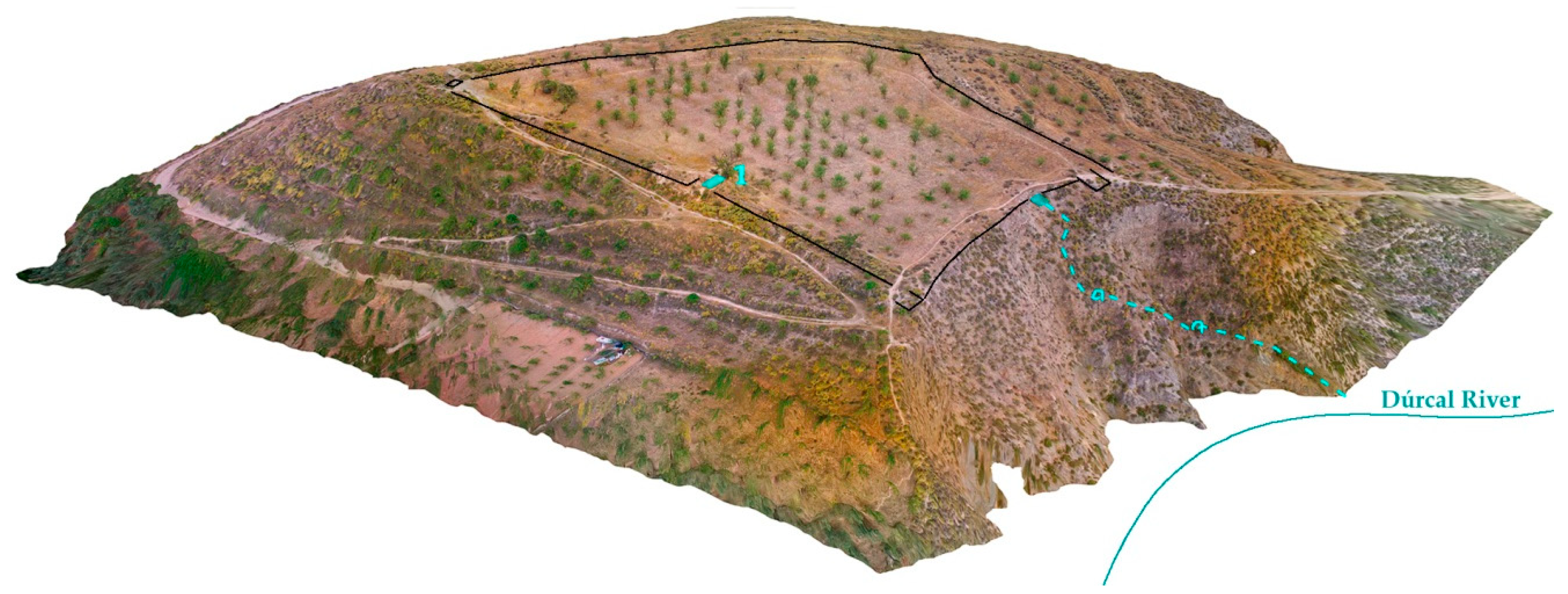
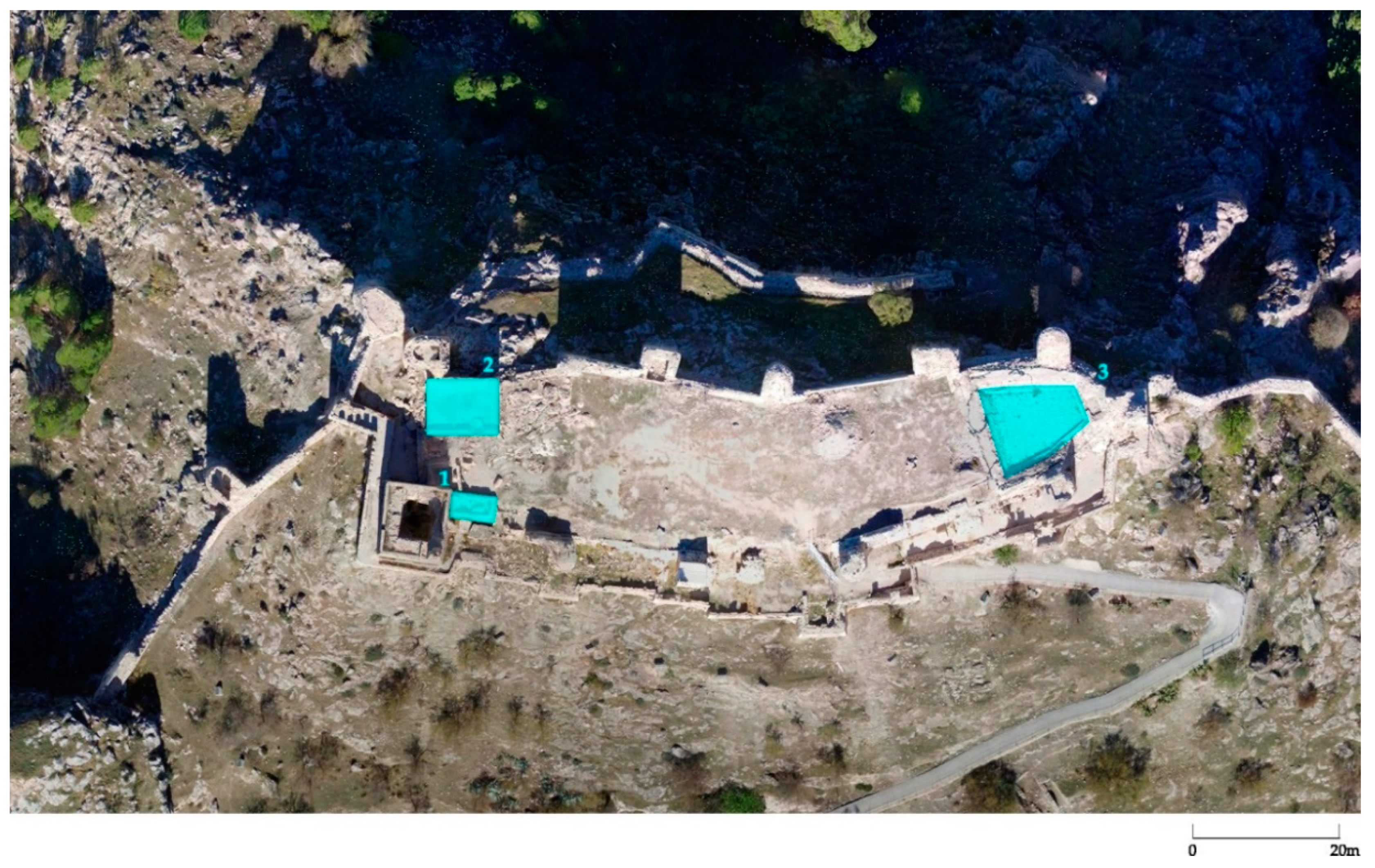
2.6.2. Alcazaba of Dúrcal

The Castle of Dúrcal (0.67 ha) is situated on a slight hill that leans out over the bed of the Dúrcal River, and culminates the plain at the bottom of the western foothills of Sierra Nevada, in the Lecrín Valley. No more remains are preserved than the foundations of some towers, built in rammed-earth and masonry, some parts of the wall and a cistern. However, the walled enclosure has lost much of its identity due to the poor state of these remains and the transformation of the inner terrain, now dedicated to farming.
The hill is defined by the ravine of the Baño in the south-southeast, and the Dúrcal River in the west. Towards this side, the hill has a strong drop. The north side presents a smoother access where there are several paths leading towards the tower located at the western end.
The cistern was attached to what would be the northern stretch of the wall, next to the remains of one of the towers. It measures 2.10 m × 5.00 m and completely conserves its barrel vault which is built at ground level. Apart from its central hollow of the vault, it has a series of breaks on two of its sides; one of them is used as an access, the other is filled with rubble and earth. There are no traces of channels or pipes in its walls.
The main sources of water collection appear on the sides with steepest slopes, at about 150 m below the level of the fortress (795 m above sea level). Despite this strong difference in height, the existence of open passages in the rock descending from the hill to the river-bed allows us to hypothesize that the water would be captured directly from the river or from a channel situated at a medium height. These passages were used as a protected access (Figure 10). It would be necessary to have archaeological data to verify the way in which the water was driven from the west side to the cistern.

2.7. Alcazaba of Moclín and Píñar—Cisterns with Self-Sufficient Water Supply

Finally, there are some cases in which the cisterns have their own supply, either natural through the land or through their own rainwater collection systems. A well-known case is the Cistern of the Rain, located at a higher level than the Alhambra, at about 930 m above sea level, at the head of one of the ravines that drop towards the Darro River. This cistern may have been one of the water collection points for the hydraulic complex of the Alberca Rota.
It was reproduced in an engraving by Joris Hoefnagel from 1563, included in the Civitates Orbis Terrarum edited by Georg Braun (1572–1618). This illustration clearly shows a structure with an inverted roof, as a compluvium, with the purpose of collecting the rainwater and pouring it into the cistern through a central oculus.
However, this is not their only source of supply, since the cistern is located on a natural spring that provides water. Although the oculus is currently blocked up, the cistern continues to be filled with water.

2.7.1. Alcazaba of Moclín

The alcazaba of Moclín is situated on an isolated hill, located between Sierra de Enmedio and Sierra de la Hoz, reaching an altitude of 1100 m above sea level. It has strong rocky slopes to the north, east, and west. The settlement and access were therefore associated with the slight hillside towards the south. The alcazaba (0.31 ha), located at the top, preserves most of its double wall, towers, and some interior remains excavated in the last archaeological interventions.
The variety of constructive elements shows the continuous evolution of this fortress, dated from the Almohad period (eleventh to twelfth century) to the processes of refortification carried out by Yūsuf I and Muḥammad V during the Nasrid period (García Porras 2014).
Inside the alcazaba, there are two cisterns. One of them, with only one nave, measures 5.40 m × 2.00 m and has lost its vault and part of its walls. It is twinned with the main tower and another perpendicular space, whose purpose is unknown. This tower has undergone an important evolution since it now has a masonry facing reinforcement of a massive rammed-earth tower. This cistern could have been very close to one of the first lines of the wall and could correspond to the first periods in the development of the fortress. However, it seems unlikely that it was fed through a collection system from the tower, as it is not part of this construction.
There is another very large cistern (6.70 m × 4.50 m), adjoined to the north wall. It retains its curbstone in its southern wall. There is evidence that at some moment, its vault was reconstituted after a break in its central part. The hypothesis is that this cistern could have been fed either by collecting rainwater on its own roof (73 m2) or by a channel that reached the cistern along the top of the wall, although there is no evidence of where this channelling could come from.
At this highest part of the hill of Moclín, there is also an extensive area with a slightly lower level adapted to the eastern point of the alcazaba. It is consolidated by a lime concrete parapet. This structure could be a pond, but there are no connections with the rest of the alcazaba or with the nearby stretches of the wall (Figure 11).
In this case, the hill is not apparently associated with the source of any river; the ravine runs about 500 m below on its southern slope, and the nearest natural water source is on the northern slope of Morrón del Hacho, at 1030 m above sea level. So, if this were the water collection point, an important syphon would be necessary to raise the water 80 m up to the level of the alcazaba up a rocky slope, which shows no remains of any hydraulic infrastructure.

2.7.2. Alcazaba of Píñar

The alcazaba of Píñar is situated on an isolated promontory at about 1120 m above sea level, in line with an area dominated by other lower hills. The Píñar River and the ravine of El Gaterón are the two depressions that mark the hill of this fortress. The alcazaba (0.22 ha) preserves most of its walls, together with two cisterns. There is a variety of construction techniques that demonstrates the continuous evolution of this fortress, which is characteristic of other frontier castles of the Nasrid kingdom (Bonet García 2007).
One of the aljibes is located near the access tower. It is a rectangular one-nave cistern, and there are no remains of its vault. It is not linked to the tower; therefore, it could be an autonomous element regarding its water collection.
On the other hand, close to the north wall and apparently isolated from any other structure, there is a large two-nave cistern, covered by slightly pointed vaults (Figure 12a). Although the headwalls that protrude from ground level have disappeared, the traces of the curbstone are maintained. Near the curbstone, on the outside and at ground level, there are the remains of two channels that bifurcate in the union between both vaults, going to the inner corners of both naves. These channels preserve traces of the ceramic pieces which would form the drain and, although the pipes have not been conserved, they clearly mark the direction by which the water would have entered into the cistern. This direction points to the area where the first cistern is located (Figure 11b).
The presence of the trace of these two entrance channels, together with the absence of gaps in their vaults, raises the possibility that it was supplied by a channel or irrigation ditch that would run through the courtyard of the alcazaba.

3. Conclusions

In the last decades, in depth studies have been conducted on the systems of the hydraulic supplies to the Andalusian settlements and their agricultural areas. In this context, it is essential to progress knowledge of the processes of water supply related to the fortresses. Water was a basic resource from the first moment of their construction, as well as during their development and evolution, and was a determining factor during armed conflicts.
In many cases, the preservation of aljibes as well as other apparently disconnected hydraulic elements, has led to the conclusion that many of them were only supplied with the rainwater collected in these cisterns. However, the panorama that emerges as a result of the study of these infrastructures seems to be much more complex and advanced, even when a great deal of the channelling systems has been lost. Therefore, we must continue to delve deeper into the signs presented by many fortresses, and be aware of the multitude of combined techniques that were known in al-Andalus regarding the systems of uptake, conduction, raising, and storage of water.
The status of the last Muslim kingdom in Iberia as a tributary territory of Castile and its favourable geographic position helped to prolong the small Nasrid Emirate of Granada for almost 250 years, allowing it to prosper as a crossroad of trade between medieval Europe and the Maghreb, as well as acting as a natural refuge for Muslims fleeing the conquered territories by Christians.
The result of this concentration of human capital and accumulated knowledge led to one of the most intense cultural flourishes of Islam (Peláez Rovira 2009). The mastery achieved during this period was not only in the architecture and the art, which reached their maximum splendour in the palatial ensemble of the Alhambra, but also in the hydraulic engineering, as they managed to gather and update all the water supply techniques known until the Late Middle Ages in a universe of palaces, agricultural estates, gardens, ponds, and fountains. This knowledge was not only implemented in the seat of the Nasrid power but, as far as possible, it was also put into operation in other fortresses built or refurbished during this period.

Author Contributions

Conceptualization, L.J.G.-P.; Writing, L.J.G.-P. and S.P.M.

Funding

The general study of these fortresses has been developed in parallel to different projects led by Luis José García-Pulido and Jonathan Ruiz-Jaramillo, at the University of Malaga, and funded by the Ministerio de Economía y Empresa, Gobierno de España (HAR2016-79689-p) and the Centro de Estudios Andaluces, Junta de Andalucía (PRY/259/17). Part of the studies referred in this paper to the Alhambra have been developed within some restoration projects on the hydraulic system of the Alhambra, funded by Patronato de la Alhambra y Generalife.

Conflicts of Interest

The authors declare no conflict of interest.

References

  1. Almagro Gorbea, Antonio. 2010. The Umayyad Palaces between the East and the West. In Umayyad Legacies. Medieval Memories from Syrian to Spain. Edited by Antoine Borrut and Paul M. Cobb. Leiden: E. J. Brill, pp. 475–513. [Google Scholar]
  2. Aranda Jiménez, Gonzalo, Sergio Fernández Martín, Martín Haro Navarro, Fernando R. Molina Ricardo, and Margarita Sánchez Romero. 2008. Water control and cereal management on the Bronze Age Iberian Peninsula: La Motilla del Azuer. Oxford Journal of Archaeology 27: 241–59. [Google Scholar] [CrossRef]
  3. Barceló i Perelló, Miquel. 1989. El diseño de espacios irrigados en al-Andalus. Un enunciado de principios generales. In El agua en zonas áridas. Arqueología e historia. Hidráulica tradicional de la provincia de Almería. Almería: Instituto de Estudios Almerienses, pp. 2013–47. [Google Scholar]
  4. Barceló i Perelló, Miquel, Ramon Martí, Maria Antònia Carbonero Gamundí, and Guillem Rosselló-Bordoy. 1986. Les aigües cercades: els qanat(s) de l’illa de Mallorca. Palma de Mallorca: Institut d’Estudis Baleárics. [Google Scholar]
  5. Barceló i Perelló, Miquel, Patrice Cressier, Antonio Malpica Cuello, and Guillem Roselló-Bordoy. 1987. Investigaciones en el Castillejo (Los Guájares–Granada). In Les illes orientals d’al-Andalus i les seves relacions amb Sharq Al-Aldalus, Magrib i Europa cristiana (ss. VIII-XIII). V Jornades d’estudis històrics locals. Palma de Mallorca: Institut d’Estudis Baleàrics, November 28–30. [Google Scholar]
  6. Basset, Henri, and Henri Terrasse. Sanctuaires et forteresses almohades (suite). Le ribāṭ de Tiṭ. Le Tasghimout. Hespéris 2: 117–71.
  7. Bermúdez López, Jesús. 1992. Introducción a la estructura urbana de la Alhambra. In Al-Andalus. Las artes islámicas en España. Edited by Jerrilynn D. Doods. Madrid: El Viso Ed. [Google Scholar]
  8. Berthier, P. 1938. Essai sur l’Histoire du Massif de Moulay Idris. De la conquête musulmane à l’établissement du Protectorat français. Rabat: Éditions Félix Moucho. [Google Scholar]
  9. Bestué Cardiel, Isabel, and Ignacio González Tascón. 2006. Breve guía del patrimonio hidráulico de Andalucía. Sevilla: Agencia Andaluza del Agua, Junta de Andalucía. [Google Scholar]
  10. Bonet García, María Teresa. 2007. Piñar (Granada). Restauración de un castillo de frontera. Spain: Arqueología Medieval 85. Available online: http://www.arqueologiamedieval.com (accessed on 5 March 2019).
  11. Cáceres, Toribio. 1914. Invento de los árabes de Granada equivalente al ariete hidráulico’. In Asociación Española para el Progreso de las Ciencias. Congreso de Granada. Ciencias de la aplicación. Madrid: Eduardo Arias impr, vol. IX, pp. 77–82. [Google Scholar]
  12. Caballero Cobos, Alejandro, and Luis José García-Pulido. Forthcoming. Madīnat Basta. La Baza nazarí. In Ciudades nazaríes: estructura urbana, sistema defensivo y suministro de agua. Edited by Antonio Orihuela Uzal. Granada: Universidad de Granada, Patronato de la Alhambra and CSIC.
  13. Cara Barrionuevo, Lorenzo. 2005. Ciudades portuarias, alquerías y comercio en el sudeste peninsular. El ejemplo de Almería en la Edad Media. Arqueología medieval 9: 125–37. [Google Scholar]
  14. Carranza Sell, Fanny de. 2010. Alcazaba de Málaga. Málaga: Esirtu. [Google Scholar]
  15. Castaño Aguilar, José Manuel, Pedro Aguayo de Hoyos, Pilar Delgado Blasco, Pilar Ordoñez Vergara, Bernardina Padial Robles, and Karlheinz Weyh. 2005. Carta Arqueológica Municipal de Ronda: la Ciudad. Sevilla: Consejería de Cultura. [Google Scholar]
  16. Castaño Aguilar, José Manuel. Forthcoming. Madinat Runda: la Ronda Nazarí. In Ciudades nazaríes: estructura urbana, sistema defensivo y suministro de agua. Edited by Antonio Orihuela Uzal. Granada: Universidad de Granada, Patronato de la Alhambra and CSIC.
  17. Cobos Rodríguez, José Juan. 2014. El río de la Villa de Antequera (Málaga): eje hidráulico para una ciudad medieval y sus huertas. Miscelánea medieval murciana 38: 29–49. [Google Scholar]
  18. Córdoba de la Llave, Ricardo, and Faustino Rider Porras. 1994. Aljibes hispano-musulmanes de la provincia de Córdoba. Meridíes 1: 161–219. [Google Scholar]
  19. Cressier, Patrice. 1991. Agua, fortificaciones y poblamiento: el aporte de la arqueología a los estudios sobre el sureste peninsular. Aragón en la Edad Media 9: 403–28. [Google Scholar]
  20. Cressier, Patrice, and Larbi Erbati. 1999. Note sur la forteresse almorávide du Tāsgimūt. Archéologie Islamique 8–9: 55–66. [Google Scholar]
  21. De Hoyos, Pedro Aguayo, José Manuel Castaño Aguilar, and Bernardina Padial. 2004. Análisis arqueológico de una manzana. Intervenciones de urgencia en el casco antiguo de Ronda, 1994–2000. Anuario Arqueológico de Andalucía 2: 772–88. [Google Scholar]
  22. De Hoyos, Pedro Aguayo, and José Manuel Castaño Aguilar. 2000. Estado de la cuestión sobre la estructura urbana de la ciudad de Ronda en época medieval. In Ciudad y territorio en al-Andalus. Edited by Lorenzo Cara Barrionuevo. Granada: Athos-Pérgamos, pp. 365–97. [Google Scholar]
  23. Escalante Jiménez, José. 2008. El abastecimiento de agua en Antequera. El memorial de Yllanes Sancho de Toledo (1545). Antequera: Excmo. Ayuntamiento de Antequera. [Google Scholar]
  24. Feijoo Martínez, Santiago, and Miguel Alba Calzado. 2005. El sentido de la Alcazaba emiral de Mérida: su aljibe, mezquita y torre de señales. Mérida, excavaciones arqueológicas 8: 565–86. [Google Scholar]
  25. García Porras, Alberto. 1995. Cerámica nazarí tardía y cristiana de “El Castillejo” (Los Guájares, Granada). Arqueología y territorio medieval 2: 243–58. [Google Scholar] [CrossRef]
  26. García Porras, Alberto. 2009. Cerámica y espacio doméstico. El poblado fortificado de “El Castillejo” (Los Guájares, Granada). Paper presented at VIII Congreso Internacional de Cerámica Medieval en el Mediterráneo Occidental, tomo II, Almagro, Ciudad Real, Spain, February 27–March 3. [Google Scholar]
  27. García Porras, Alberto. 2014. La frontera del reino nazarí de Granada. Origen y transformaciones de un asentamiento fronterizo a partir de las excavaciones en el castillo de Moclín (Granada). Revista del Centro de Estudios Históricos de Granada y su reino 26: 53–86. [Google Scholar]
  28. García-Pulido, Luis José, Julio Navarro Palazón, and Fernando Ortega Camacho. Forthcoming. Análisis de las estructuras emergentes del castillo de la Peña, cabeza de la Encomienda Calatrava de Martos (Jaén). Arqueología de la Arquitectura.
  29. García-Pulido, Luis José. 2016. The mastery in hidraulic techniques for water supply at the Alhambra. Journal of Islamic Studies 27: 355–82. [Google Scholar] [CrossRef]
  30. García-Pulido, Luis José, Paula Sánchez Gómez, Manuel Pérez Asension, María del Mar Villafranca Jiménez, Francisco Lamolda Álvarez, and Francisco Urbistondo Tamayo. 2011. Primera fase de intervención arqueológica y puesta en valor de la Alberca Rota y el Pozo Este del cerro del Sol (Alhambra, Granada). Paper presented at XVIII Congreso Internacional Conservación y Restauración de Bienes Culturales, Granada, Spain, November 9–11. [Google Scholar]
  31. Gómez-Moreno Martínez, Manuel. 1889. Crónica del “centro”. Sección de Excursiones. Boletín del Centro Artístico de Granada 60: 109–10. [Google Scholar]
  32. Gómez-Moreno Martínez, Manuel. 1966. Granada en el siglo XIII. Cuadernos de la Alhambra 2: 16. [Google Scholar]
  33. Gurriarán Daza, Pedro. Forthcoming. Madinat al-Mariyya: la Almería Nazarí (ss. XIII-XV). In Ciudades nazaríes: estructura urbana, sistema defensivo y suministro de agua. Edited by Antonio Orihuela Uzal. Granada: Universidad de Granada, Patronato de la Alhambra and CSIC.
  34. Gutiérrez Ayuso, Alonso. 2001. Contribución al conocimiento de los aljibes hispanomusulmanes extremeños. Tipología de un ejemplo de arquitectura del agua. Norba-arte XX–XXI: 7–27. [Google Scholar]
  35. Higuera Mata, Alicia de la, and Antonio Morales Delgado. 1999. La almunia de los alijares según los autores árabes: Ibn ‘Āsim e IbnZamrak’. Cuadernos de la Alhambra 35: 33. [Google Scholar]
  36. Huici Miranda, Ambrosio. 1954. Ibn ‘Idhārī al-Marrākushī: al-Bayān al-mughrib fi ikhtiṣār akhbār mulūk al-Andalus wa-l-Maghrib: al-qism al-thālith: Tārīkh al-Muwaḥḥidīn. Tetuan: Editorial Maroquí. [Google Scholar]
  37. Hayyan, Ibn. Crónica del califa ‘Abderrahaman III an-Nasir entre los años 912 y 942 (al-Muqtabis V). Introduced and translated into Spanish by María Jesús Viguera Molins, Federico Corriente and José María Lacarra. Zaragoza: Anubar, Instituto Hispano-Árabe de Cultura.
  38. Lévi-Provençal, Evariste. 1957. España Musulmana hasta la caída del califato de Córdoba (711–1031). Historia de España. Edited by Ramón Menéndez Pidal. Madrid: Tomo IV. [Google Scholar]
  39. Lirola Delgado, Jorge. 2005. Almería andalusí y su territorio. Textos geográficos. Almería: Fundación Ibn Tufayl de Estudios Árabes. [Google Scholar]
  40. López Guzmán, Rafael, Jesús Bermúdez López, and Manuel Acién Almansa. 2002. Arquitectura de al-Andalus: Almería, Granada, Jaén, Málaga. Granada: Comares. [Google Scholar]
  41. Malpica Cuello, Antonio. 1991. El complejo hidráulico de los Albercones. Cuadernos de la Alhambra 27: 65–101. [Google Scholar]
  42. Malpica Cuello, Antonio. 1996. Poblamiento y castillos en Granada. Granada: Lunwerg Ed. [Google Scholar]
  43. Malpica Cuello, Antonio. 2002. La Alhambra de Granada, un estudio arqueológico. Granada: Universidad de Granada. [Google Scholar]
  44. Marcos Cobaleda, María. 2010. Los almorávides: Territorio, arquitectura y artes suntuarias. Ph.D. Thesis, University of Granada, Granada, Spain. [Google Scholar]
  45. Martín García, Mariano, Jesús Bleda Portero, and José María Martín Civantos. 1999. Inventario de la arquitectura militar de la provincia de Granada (Siglos VIII al XVIII). Granada: Diputación Provincial de Granada. [Google Scholar]
  46. Melero García, Francisco, and Manuel Romero Pérez. Forthcoming. Madīnat Antaqīra: la Antequera nazarí. In Ciudades nazaríes: Estructura urbana, sistema defensivo y suministro de agua. Edited by Antonio Orihuela Uzal. Granada: Universidad de Granada, Patronato de la Alhambra and CSIC.
  47. Meunié, Jacques, and Charles Allain. 1956. La forteresse almorávide de Zagora. Hespéris 3–4: 305–23. [Google Scholar]
  48. Miró Domínguez, Aurora. 1987. Ronda. Arquitectura y urbanismo. Málaga: Confederación de Cajas de Ahorros. [Google Scholar]
  49. Molina Fajardo, Aurora. 2007. Revisión bibliográfica para el estudio del patrimonio histórico-artístico en el Valle de Lecrín (Granada). Siglos XIII al XVII. Ph.D. thesis, University of Granada, Granada, Spain. [Google Scholar]
  50. Navarro Palazón, Julio, and Pedro Jiménez Castillo. 1995. El agua en la vivienda andalusí: abastecimiento, almacenamiento y evacuación. Verdolay 7: 401–12. [Google Scholar]
  51. Navarro Palazón, Julio, Antonio Orihuela Uzal, and Antonio Reyes Martínez. 2018. Salobreña. De alcazaba palatine a fortificación castellana en la costa de Granada. In Poblamiento e intercambios en las zonas costeras del mar de Alborán. Edited by Bilal Sarr. Granada: Alhulia Ed. [Google Scholar]
  52. Netzer, Ehud. 1991. Masada III. In The Yigael Yadin Excavations 1963–1965 Final Reports. The Buildings. Stratigraphy and Architecture. Jerusalem: Israel Exploration Society. [Google Scholar]
  53. Onorato, María Auxiliadora Moreno, Francisco Contreras Cortés, Juan Antonio Cámara Serrano, Luis Arboledas Martínez, Eva Alarcón García, and Margarita Sánchez Romero. 2008. Nuevas aportaciones al estudio del control del agua en la Edad del Bronce. La cisterna de Peñalosa (Baños de la Encina, Jaén). Cuadernos de Prehistoria y Arqueología de la Universidad de Granada 18: 297–316. [Google Scholar]
  54. Orihuela Uzal, Antonio. 1996. Casas y palacios nazaríes. Siglos XIII–XV. Barcelona: El Legado Andalusí-Lunwerg Ed. [Google Scholar]
  55. Orihuela Uzal, Antonio, and Carlos Vílchez Vílchez. 1991. Aljibes públicos de la Granada Islámica. Granada: Ayuntamiento de Granada. [Google Scholar]
  56. Padilla Mellado, Lorenzo Luis, and Manuel Espinar Moreno. 2007. Arquitectura defensiva del Valle de Lecrín. Granada: ASB Producciones Editoriales. [Google Scholar]
  57. Pavón Maldonado, Basilio. 1990. Tratado de arquitectura hispanomusulmana. 1 Agua. 2 Ciudades y fortalezas. Madrid: Consejo Superior de Investigaciones Científicas. [Google Scholar]
  58. Peláez Rovira, Antonio. 2009. El emirato nazarí de Granada en el siglo XV: dinámica política y fundamentos sociales de un estado andalusí. Granada: Universidad de Granada. [Google Scholar]
  59. Pérez de Guzmán y Gallo, Juan. 1910. La Casa del Rey moro en Ronda. Madrid: Imprenta de Fortanet. [Google Scholar]
  60. Ricard, Prosper. 1938. Une forteresse maghrébine de l’Anti-Atlas (XIIe siècle). Quatrième Congrès de la Fédération des Sociétés Savantes de l’Afrique du Nord 2: 641–50. [Google Scholar]
  61. Rivera Valenzuela, Juan María de. 1873. Diálogos de memorias eruditas para la historia de la nobilísima ciudad de Ronda. Ronda: Rafael Gutiérrez Giménez Ed. [Google Scholar]
  62. Romero Pérez, Manuel. 2002. Las murallas de Antequera: una aproximación arqueológica. Revista de estudios antequeranos 13: 145–84. [Google Scholar]
  63. Romero Pérez, Manuel. 2007. Memoria Final. Actuación Arqueológica Puntual Centro de Interpretación de la Ciudad de Antequera. Antequera, Málaga 2007. Memoria inédita. Antequera: Ayuntamiento de Antequera, Oficina Arqueológica. [Google Scholar]
  64. Rubiera Mata, María Jesús. 2005. Los jardines y patios de la Alhambra según Ibn Zamrak’. In La ciudad en el Occidente Islámico Medieval. Jardines de al-Andalus. Granada: Preview Proceedings, art. VIII, pp. 5–7. [Google Scholar]
  65. Rubio Gandía, Miguel Ángel, Miguel Giménez Yanguas, and José Miguel Reyes Mesa. 2002. El antecedente del ariete hidráulico. Invención de la Granada medieval. In Patrimonio industrial en Granada. Granada: Universidad de Granada. [Google Scholar]
  66. Ruggles, D. Fairchild. 2008. Islamic Gardens and Landscapes. Philadelphia: University of Pennsylvania Press. [Google Scholar]
  67. Salmerón Escobar, Pedro. 2006. La Alhambra estructura y paisaje, 3rd ed. Granada: Collec. La Biblioteca de la Alhambra. [Google Scholar]
  68. Sierra de Cózar, Pedro (coord.). 1990. Antiguos sistemas de suministro de agua a Ronda. Acueducto de la Fuente de la Arena. Ronda: Servicio de Publicaciones del Centro de Profesores de Ronda. [Google Scholar]
  69. Velázquez de Echeverría, Juan. 1764. Paseos por Granada y sus contornos. Granada: Imp. de Nicolàs Moreno, vol. 1. [Google Scholar]
Figure 1. Fortresses studied in relation to their water supply. Created by authors.
Arts 08 00063 g001
Figure 2. Hypothesis on the development of the Alhambra and its surroundings at the time of maximum expansion during the second half of the fourteenth century. Created by authors.
Arts 08 00063 g002
Figure 3. Reverse qanāts around the Alhambra. (a) Well near Albercón de las Damas; (b) Upper cross-section of the East Well of Cerro del Sol, linked to the Little Arches Water Channel. Created by authors.
Arts 08 00063 g003
Figure 4. (a) Inside ortho-corrected photogrammetry of the Airon Well (Alcazaba of Málaga); (b) Well connected to the Albercón de las Damas at the Generalife. Created by authors.
Arts 08 00063 g004
Figure 5. Ortho-corrected photogrammetry of the Alcazaba of Málaga. Hydraulic constructions and hypothesis on the irrigation line: (1) Pozo Airón, (2) cistern, (3) ḥammām, and (4) ceramic drain pipes. Created by authors.
Arts 08 00063 g005
Figure 6. Alcazaba of Almería. Hillside terraces and hydraulic constructions: (1) Noria del Viento Tower, (2) the ponds of the palace, (3) the Baño de la Tropa (ḥammām), (4) the cistern next to Aljama mosque, and (5) the cistern on the lower terrace. Created by authors.
Arts 08 00063 g006
Figure 7. Fortress of Mondújar (a) View of the aljibe outside the walls. (b) Hypothesis on the water supply with cistern inside (1) and outside (2) the fortress and its blocked off arch. Created by authors.
Arts 08 00063 g007
Figure 8. Fortified settlement of Los Guájares. Hypothesis of the water supply system. (a) Situation of the cistern (b) View of the hill’s summit line, the water tank, and channels. Created by authors.
Arts 08 00063 g008
Figure 9. South-east prospect of the Alcazaba of Lojuela. Hypothesis on the coracha and detail of the Acequia de los Arcos. Created by authors.
Arts 08 00063 g009
Figure 10. Photogrammetric model of the hill of the Alcazaba of Dúrcal. (1) Cistern and, in dotted lines, hypothesis of the protected passage. Created by authors.
Arts 08 00063 g010
Figure 11. Orto-corrected photogrammetry of the Alcazaba of Moclín. Isolated hydraulic constructions: (1) Oldest cistern, (2) large cistern, and (3) possible collection surface. Created by authors.
Arts 08 00063 g011
Figure 12. Cistern formed by two naves in the Alcazaba of Piñar. (a) View of the two naves cistern (b) Detail of the ceramic pipes at the joint of the vaults. Photographies by authors.
Arts 08 00063 g012

