Article

Tracking Change in Rock Art Vocabularies and Styles at Marapikurrinya (Port Hedland, Northwest Australia)

Centre for Rock Art Research and Management, School of Social Sciences, University of Western Australia, Crawley, WA 6009, Australia
Arts 2025, 14(5), 123; https://doi.org/10.3390/arts14050123 (registering DOI)
Submission received: 19 May 2025 / Revised: 26 September 2025 / Accepted: 27 September 2025 / Published: 11 October 2025
(This article belongs to the Special Issue Advances in Rock Art Studies)

Abstract

Track engravings dominate the rock art assemblage across Marapikurrinya (Port Hedland) in Northwest Australia, with social change through time linked to changes in how and when this graphic vocabulary is employed. Discrete styles have been identified within the broader engraving body, which is argued to have been produced semi-continuously over the last 7000 years, from the point of sea-level stabilisation in this region. It is proposed that changes in these styles reflect and negotiate environmental, demographic, and social changes. In the most recent stylistic phases, track motifs dominate, and it is argued to reflect change in marking strategy, from localised territorial bounded art to regional social harmonisation. This paper explores the potential functions of track motifs as a vocabulary distinct from other figurative art, using Marapikurrinya as a case study.

1. Introduction

This paper explores the Marapikurrinya (Port Hedland, Northwest Australia) engraving province, in particular its extensive track repertoire, and how this rock art shows social change through time linked to the arid-zone cultural bloc. Marapikurrinya is located on the modern-day coastline and falls within a maritime desert (Veth et al. 2014), being located on a thin temperate coastline, fringed by the semi-arid Abydos Plain and Pilbara desert. The rock art province is stylistically unique and internally heterogeneous. Discrete and sequential styles have been identified within this engraving body (Harper 2016, 2017; McCarthy 1962), which is argued to have been produced semi-continuously over the last 7000 years, from the time of sea-level stabilisation in this region (Lewis et al. 2013). It is proposed that changes in these styles reflect and negotiate environmental, demographic, and social changes. Track motifs form a significant component (~30% of all recorded engravings) within this repertoire, both human and other animal, and have connections with arid-zone track marking systems. The Marapikurrinya canvas, with low-elevation calcarenite ridges that you walk over, is pertinent in the creation of meaning for this motif type. Diachronically, in the most recent stylistic phase, track motifs dominate, and it is argued that this reflects a change in marking strategy at Marapikurrinya, from localised territorial bounded art to regional social coordination.
Track motifs are generally under-researched (e.g., Carden 2009; Lenssen-Erz et al. 2023), lumped with geometric rock art, “leaving them badly under-researched despite their global ubiquity and broad chronological distribution” (Lenssen-Erz et al. 2023, p. 2), and largely interpreted economically around hunting knowledge (e.g., Mithen 1988; see Motta and Veth 2021; Schaafsma 2015). In looking at this track repertoire, this paper explores the potential functions of track motifs as a vocabulary distinct from both geometrics broadly and other ‘figurative’ art, using Marapikurrinya as a case study. These analytical categories will be assessed for their usefulness when looking at style and function. The relationships between these tracks and other Australian arid-zone track styles are presented to understand human use of this seasonally arid landscape. The specific questions that will be explored here include how track motifs can be used to mark space within an engraved rock art body; how tracks change in style and dominance through time at Marapikurrinya; whether definitions of tracks outside of ‘figurative’ classifications and allied with ‘geometric’ motifs are valid and what these classifications tell us about symbolic vocabularies when looking at style; and what perceived changes in track motif dominance can tell us about the local story of the human use of Marapikurrinya as a seasonally arid place.

2. Background

2.1. Cultural and Environmental Context

On the northwestern coast of Western Australia, Marapikurrinya, the coastal harbour and adjacent mainland at Port Hedland, is located on the current coastline, within the biogeographic Pilbara region. Marapikurrinya is one clan estate of Kariyarra country, and loosely translates as pointing hand, referring to the shape of the harbour and tidal creeks (see Figure 1). Kariyarra country covers both the Pilbara coastline and hinterland (Abydos Plain), and Marapikurrinya sits at the northern edge of this area, adjacent to Njamal country. The Pilbara bioregion has distinct linguistic and cultural groups, building from the work of Norman Tindale (1974: see Figure 2).
Marapikurrinya is classified as a ‘maritime desert’, a specific ecozone coined by Veth et al. (2014, p. 156), which takes advantage of coastal and marine bounty, along with other arid resources: coastal deserts are where Aboriginal people have deployed ‘hybrid’ societies focusing on the bounty of the littoral zone alongside the more scattered resources of the arid interior (Veth et al. 2014, p. 156). This geographical setting is important for the discussion of track motifs in this paper, as whilst track motifs are recorded across the majority of all Australian rock art bodies, they are specifically associated with arid-zone marking (e.g., Mountford 1937; Maynard 1979; Franklin 2004; McDonald 2017).
Additionally, the formation of Marapikurrinya as a coastal locale is the result of changing sea-levels through time. The geology on which engravings are made is a Pleistocene-aged limestone (Bosscut formation oolitic calcarenite: Beard 1975; Harrison 2009), likely lithified calcareous sand dunes (Clarke 1978; Semeniuk 1996). Today, these are low-elevation rocky platforms, largely horizontal, which have been utilised as platforms for various purposes, including living, camping, reorganising into stone arrangements, and engraving. This relatively soft and flat limestone contrasts with the bordering Abydos Plain geology, which comprises largely Archaean granites (Beard 1975). The Marapikurrinya harbour itself has no major river draining into it from the Abydos Plain and instead, is likely a relict Pleistocene river delta (Harrison 2009; Paling 2002).

2.2. Archaeology and Chronology

The period of time of interest here is from approximately 7000 years ago to the present, as this marks sea-level stabilisation in the region (Lewis et al. 2013; excluding two high sea-stands, Harrison 2009), whilst Aboriginal occupation of the Pilbara is firmly dated from 45 to 50,000 years ago (Dortch et al. 2019; Morse et al. 2014; Slack et al. 2018, 2024; Veth et al. 2014). As a result of rising sea levels, Marapikurrinya becomes a tidal harbour with tidal islands, which were once elevated portions of a broader coastal plain, as with the Dampier Ranges (Murujuga: McDonald 2015) and Barrow and the Montebello Islands (Veth et al. 2014). Most archaeological sites in and around Marapikurrinya date to the Holocene, and older archaeology is assumed to be now inundated (Harper 2017).
This timeframe addresses three phases of environmental and demographic change in northwest Australia, as synthesised by Williams et al. (2015):
  • Holocene Climatic Optimum: ~9000–6000 ya;
  • El Niño South Oscillation (‘ENSO’) aridity impacts: ~4500–2000 ya; and
  • La Niña climatic amelioration and Intensification: ~2000 ya to the present.
Immediately prior to the Holocene Climatic Optimum comes the proliferation of large mangrove forests across the northwest (Woodroffe et al. 1985), with changes such as increased humidity and changes to the tidal regime allowing for mangrove growth (Jennings 1975; Semeniuk and Johnson 1982). This in turn fosters resource productivity of these intertidal zones and development of mangrove economies (McDonald and Berry 2017). Following the Holocene Climatic Optimum, and with the development of ENSO from the mid- to late-Holocene, mangrove forests decrease, affecting shell species habitat and availability. This is seen across the Northwest archaeologically, with a switch from Terebralia sp. (mangrove) to Tegillarca granosa (previously Anadara granosa sandy, rock platform, and mudflat) species (Bowdler 1990; Kendrick and Morse 1990).
Archaeologically, with no rock shelter or closed sites, the main site types recorded in and around Marapikurrinya, excluding engravings, are shell middens (Harrison 2009). Archaeological salvage of seven Tegillarca granosa-dominated shell midden sites south of the Port Hedland township was undertaken by Warren (1995) and Eureka Archaeological Research et al. (2007), returning a near continuous sequence of sites between 5250 cal BP and 50 cal BP, suggesting that groups were targeting different shell beds along the estuarine system through time (Harrison 2009). This study has been critically assessed by Barham, Sullivan, and Hughes (Sullivan et al. 2011), who reject the archaeological nature of these shell beds. What this later assessment does not address are the presence of stratified lithic artefacts within the shell mounds (Eureka Archaeological Research et al. 2007), which lends weight to their archaeological nature. Research by Veitch (1999 in the area has returned the radiocarbon ages of surface shells sourced off mounded middens at 750 ± 60 BP (Terebralia sp.) and 620 ± 60 BP (Tegillarca granosa).
From this archaeological context, there is a strong narrative around seascape use of this coastal zone in the mid-to-late Holocene as evidenced largely through shell mounds and middens. The cyclonic nature of this coastline and geological formations limit further deep time deposits—however, the density and variability within the rock art provides a rich body of cultural engagement at this coastal place, which redirects this watery focus.

2.3. Tracks in Rock Art

Limited research has focused explicitly on track motifs in rock art, with a few exceptions (e.g., Carden 2009; Dobrez 2017, 2018; Lenssen-Erz et al. 2023; Schaafsma 2015; Walker 1996). Track motifs, in general, have been treated as a specific class of rock art motif—distinct from ‘figurative’ depictions of animals—and in partnership with geometric motifs that they are frequently identified alongside. As presented by Rosenfeld (2002), tracks replicate the marks left behind by animals on the land. This further conceptualisation of tracks as an icon or symbol from which whole animals can be inferred is a rich field for further exploration (e.g., Clegg 1987). Of note in a few identified locations across the globe are twisted perspective tracks—where figurative animals in rock art have tracks for feet, rather than anatomical feet, and the view is twisted to show the track attached to the end of the leg. Examples of this come from European Palaeolithic art (e.g., Clottes 2015; Mithen 1988) and the southwest USA Jornada style (Schaafsma 2015), through to Arnhem Land in northern Australia (Ouzman et al. 2002). More work could be conducted here in deconstructing these analytical class-level distinctions between tracks and figurative animals. In the following sections, this paper will summarise how tracks have been classified and common interpretations.

2.3.1. Classifying Tracks: Figurative and Geometric Connections

In an Australian context, early researchers advocated for an ‘ancient’ engraved tradition across the arid zone, comprising tracks and geometrics, that facilitated open-exchange networks and the early peopling of the continent, bolstered by the information storage potential of these motif classes (McDonald and Veth 2013). This led to pioneering research by Maynard (1979), which presented a tri-partite schema for all Australian rock art. The earliest phase she identified was named the ‘Panaramitee’, after the type-site located in the Flinders Ranges in South Australia (building on Edwards (1971) ‘track and circle’ tradition), being an engraved tradition dominated by tracks and geometric motifs, with a handful of ‘figurative’ inclusions such as infill lizards and snakes. Within the Panaramitee style, tracks make up the bulk of motifs, somewhere in the order of 60%, with this proportion or frequency being a core attribute in defining the style (Clegg 1987; Maynard 1979).
Maynard’s sequence, and, in particular, the Panaramitee style have now been roundly critiqued (e.g., Franklin 2004; McDonald and Veth 2011; McDonald 2022; Rosenfeld 1991), particularly as it now is apparent that track and geometric repertoires are not limited to ‘early’ art across the continent but continue to proliferate into the recent past, in places like Central Australia (Frederick 1999; Rosenfeld 2002) and the Pilbara (Harper 2017). For example, in Rosenfeld’s analysis of changing social geographies across arid-zone Australia being marked by synchronic changes in rock art style within track and geometric marking systems showed at key places, such as Puritjarra and Wallace Rock Hole in Central Australia, tracks are utilised in both the older art markings and in more recent time. What she distinguishes, however, is between the use of track trails or sequences, as common in occupation and open sites, and in contrast, the use of individual or static tracks as icons, linked into totemic geography and specific powerful, and sometimes restricted, narratives (Rosenfeld 2002, pp. 74–75; see also Dobrez (2017) for gesture-derived inscription of scenes and how we understand them via tracks). However, when focusing on the antiquity of this marking system, McDonald and Veth advocate for an older, largely geometric style alongside archaic faces as a unifying communication system, with ongoing use varying in space and time across the continent (McDonald and Veth 2013). This latter approach allows for the ubiquitous nature of tracks to be recognised as a key symbolling tool to enable rapid dispersal and communication across space, such as in the peopling of the Australian continent.
In other global contexts, such as Zuni rock art from the southwest of the USA, animal tracks and human hand- and footprints dominate, alongside various geometric designs, from the periods of Basketmaker III through to Pueblo III (Young 1985). These motifs are shared between rock art, pottery, and blankets, and in Zuni country, identifying particular animals from their tracks has been linked to both hunting and clan group identity—and where these repeated track motifs are found in one location being suggestive of the ritual activity of particular clans returning to the same place and marking their presence each time.

2.3.2. Interpretations: Functional, Ritual, and the Role of Placement

Connections between tracks and hunter–gatherer creators are a repeated theme in rock art research, often with an economic focus on hunting knowledge (e.g., Mithen 1988; Walker 1996). This approach has been pursued by Lenssen-Erz and colleagues in the Doro! Nawas mountains of Namibia, who worked with present-day Indigenous trackers to interpret tracks in the rock art, which comprise ~30% of known Namibian engraved art assemblage. In applying this approach, what they found was that track depictions indicated a much broader array of animal species than seen in depictions of the animals themselves amongst figurative rock art, as is the case for Marapikurrinya (Harper 2017). Similarly, McCarthy’s research at Port Hedland in Australia’s northwest, working with local informants, illuminated a greater array of bird species in the tracks including ‘native companion’ (brolga), bush turkey, seagull, duck, curlew, and galah, and for mammals, distinguished between kangaroo forepaw and dingo. Working with informants also allowed for the interpretation of scenes as narratives, such as this example from Captain George, a Kariyarra man (McCarthy 1962, p. 30):
Captain George identified one set of a large and some small human tracks as those of a man chasing a woman; he dropped his spears, shown behind him, became involved in a fight (indicated by the shields and spears in front of him). He also said that the big and the broad tracks are those of Kariyarra men, and the long slender ones are of the Minyiburu.
Focusing on tracks as reflecting hunting knowledge (Mithen 1988) provides a functional interpretive framework of tracks within rock art assemblages. Hunter–gatherer knowledge of discrete information around species, age, and health are encoded within anatomically detailed visual marking—as explored by Lenssen-Erz and colleagues whose team included present-day individuals with these connections and knowledge to interpret these kinds of information embedded within track motifs. The caution applied here is summarised by Schaafsma’s (2015) research on roadrunner tracks from Southern New Mexico, for example, where she notes that this anatomical detail can be inferred as ‘hunting magic’. Reductionist, this approach can fail at identifying connections between track motifs and their role in ritual.
The ritual and narrative role of tracks is also discussed by Carden (2009) utilising a case study from Piedra Museo, in southern Argentina. Carden breaks down stylistic choices made in the representation of tracks by classifying whether they are anatomical and naturalistic, or stylised. This distinction is used to ask questions around this spectrum of depiction and inferred symbolism, whilst stating that “although the formal distance of the track representation from the ‘natural referants’ may be relevant for exploring their symbolism, this fact should not deny the symbolic potential of naturalistic representation” (Carden 2009, p. 29). Carden’s morphological focus allowed for a distinction between prey and predator animals represented in naturalism and stylised tracks, linked to the known cosmological importance of the latter—abstracted or symbolised predator tracks.
The importance of the placement of track motifs has been discussed in the human conception of these images, as noted by Rosenfeld (2002) that track motifs often replicate the real-world imprints made by humans and other animals on flat surfaces, with links to sand art (Dobrez 2017; Munn 1973), or on different kinds of material culture such as drums, or in body paint (Schaafsma 2015). The use of the ground for illustrative and explanatory purposes is pervasive in the environment of Central Australia where there is ample inscribable ground, and this attention to the surface of the ground arises partly from a cultural preoccupation with observing the information encoded on its surface (Green 2014, p. 2). Walker and team discuss this pattern around the placement of tracks and human feet on horizontal surfaces, as opposed to walls and vertical surfaces (Walker 1996), and argue that this placement has links to cognitive perception. His research at the Matsieng creation site in Botswana notes that there is also a distinction in that the figurative art of humans and animals on the walls is painted, whereas tracks (human and other animals) are engraved and on the floor. In this way, the placement of tracks may be a useful variable for understanding functional variation.

2.4. Marapikurrinya and the Pilbara

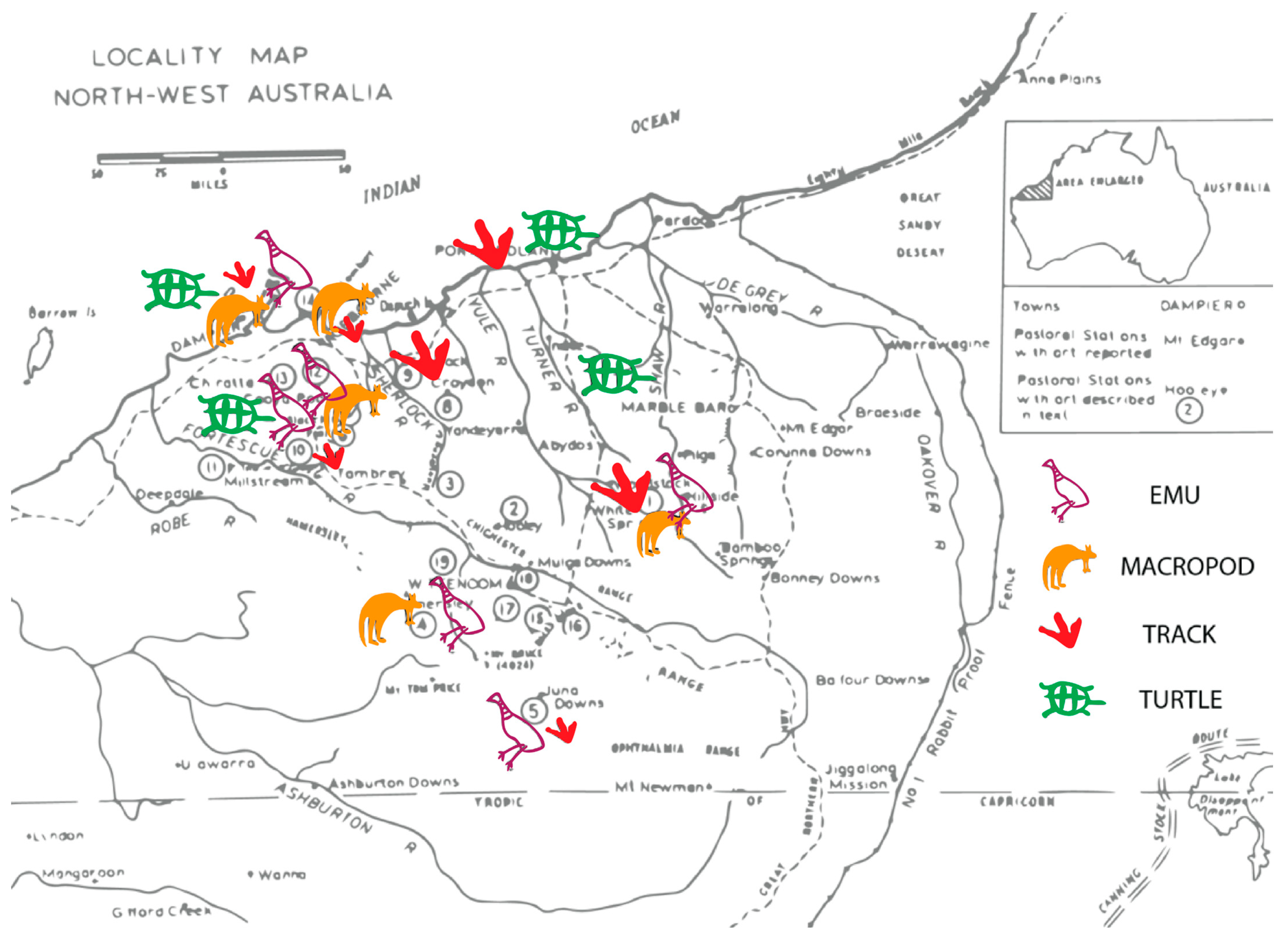
Looking particularly at northwest Australia and the rock art-rich Pilbara bioregion, early research across engraved Pilbara rock art by Wright (1968) identified high stylistic variability across this region. This research also identified variability in content across the Pilbara coastline and hinterland, and further research of the Marapikurrinya assemblage (Harper 2017) expands on Wright’s (1968) analysis assemblages (recognising that this dataset is biassed towards a large sample size at Upper Yule River, and particular stations), and for this paper, the key variables relate to where track repertoires are found, and where figurative depictions of animals are—and further where distinctions can be made between terrestrial and marine fauna. Across recorded Pilbara engravements, looking specifically at major marine and terrestrial figurative representations by species, turtles, macropod, and emus are found at both coastal and hinterland sites—and tracks are also found at both coastal and hinterland sites (Wright 1968, Figure 3). Wright identified the following terrestrial fauna: macropods, emus, dingoes, lizards, snakes, echidnas, gliders, thylacines, marsupial mice, and a single horse—with macropods identified at ten of his fourteen sites across the Pilbara (excluding Sherlock Station [143 motifs], Gregory Gorge [71 motifs], Croydon Station [14 motifs], and Pyramid Hill [11 motifs]); and the following marine fauna: turtle, crab, octopus, fish, and stingray livers—with marine fauna generally less common across sites, with turtles recorded at six of these. This division between marine and terrestrial fauna is made by the author—and draws a hard boundary between land and sea—however, there are several liminal species, including snakes, turtles, and crabs, which operate between these two surfaces.
In looking more closely at track and figurative animal depictions at Marapikurrinya, Wright’s (1968) research identified no figurative macropods or emus, whilst track motifs comprised 30% of all engravings—of which 60% or 1546 were either macropod or bird tracks, the vast remainder being human tracks (Harper 2017; McCarthy 1962: 41% track motifs). Figurative faunal engravings are common—however 85% are marine fauna, dominated by stingrays and turtles, then general marine and liminal species like crabs. Of terrestrial figurative, the majority are snakes and lizards, with one quadruped and one unusual bird motif recorded—likely a bush turkey. The absence of either emu or kangaroo motifs within the figurative component, in contrast to Murujuga (Burrup Peninsula), another coastal region to the south, is likely to reflect temporal and stylistic patterning, as discussed further below.

3. Marapikurrinya Tracks

Research undertaken by the author (Harper 2016, 2017) focused on tidal islands ‘South West Creek 4′ (‘SWC4′) and ‘Mourambine Kariyarra 3′ (‘MK3′) (Figure 1) within Marapikurrinya rock art places and recorded 8320 engravings, identifying superimposition sequences visible within this soft oolitic calcarenite. Primary fieldwork was undertaken by a team of two researchers over four weeks in 2014, targeting tidal islands whose access was restricted due to large diurnal tidal ranges (~7 m), and extensive mudflats, with limited resources on these low-elevation rocky islands. A preliminary survey indicated high levels of rock-art preservation and density, with the former notable compared with sites in the town centre, with minimal prior recording undertaken at these places. Engravings are located across low-lying carpet-like outcrops of calcarenite. The same recording strategy was deployed on each island, with an initial site survey to establish the extent of rock-art panels and locate areas of greatest density. Following this, a sampling strategy was used, to target areas of high density (to allow for the recording of complex superimpositions found in these areas), as well as panels of medium and low density, and isolated engravings. The purpose of this sampling strategy was to be able to provide comparative samples for different densities of engraving, against other archaeological and environmental factors (e.g., presence of wells/water sources), to analyse discrete site uses. Recording was undertaken with customised recording forms, a full-frame DSLR, a handheld GPS, a measuring tape, and a compass. Photographs were taken of each motif or complex panel, with landscape context shots taken where relevant. Where extensive complex panels were encountered, a monopod was used to photograph the entire panel to maintain high level contextual integrity of how the motifs and rock surfaces were integrated. A 50 mm prime lens was used for this photography, and the camera was attached to a monopod, which created a distance of approximately 2.1 m between the lens and ground surface. In total, 8320 motifs were recorded across this period, including counts and ratios of motif types, size, location, technique, form, superimposition, condition, and attribution within the McCarthy (1962) sequence, and interactions with the natural vughs in the rock surface. Additional detailed desktop recordings of particular attributes were made for motif groups pertinent to the thesis’ research questions.
In their discussion of superimpositions (and superpositions), Gunn et al.’s (2022, p. 101444) definitions make the point that
“all forms of overlap are superpositions; superimpositions are a subset that involve the total or near-total overlap of marks or images that ‘map on’ the earlier form. Differentiating between superposition and superimposition in this way allows for a consideration of not only when an image was made, but also how, once on a rock surface, pre-existing images continued to be engaged and activated through time.”
For the purposes of this paper, superimpositioning is used as these overlaps are seen as cumulative narrative construction, where lower images remain visible but clear choices and activations are made in the addition of these overlapping positions.
It has long been recognised that it is difficult to correctly identify the order of superimposed engravings, particularly without the use of magnifying or other in situ technology (e.g., Clegg 1987; Maynard 1979). Maynard (1979) and Franklin (2004) also argue that intersecting facets of engravings are obliterated with time because of erosion and patination, particularly in the case of solid figures over linear figures. During fieldwork across Marapikurrinya sites, differential weathering of engravings was observed between sites, particularly comparing Two Mile Ridge in the Port Hedland township to both SWC4 and MK3. While Two Mile Ridge has been subject to ongoing impacts (e.g., increased weathering of engravings by iron ore dust and proximity to the transport corridor/active port (Atkins 1990), these impacts have not affected sites SWC4 and MK3. Consequently, and for the benefit of superimposition analysis, differential weathering rates are often evident between different engravings, and individual peck marks are frequently identifiable. Examination of these superimpositions, particularly on panels of high repeated engraving activity, provide the opportunity to test McCarthy’s (1962) sequence, as well as the validity of inferring a sequence from engravings via visual inspection. It was found that in some situations, and particularly with highly weathered engravings, the order of engravings could not be determined. However, in the majority of superimpositions, sequencing was possible through the examination of visible peck marks, obliteration of underlying engravings, and to some extent evidenced by differential weathering rates between motifs. Whilst the weathering rates of engravings do not provide a quantifiable time relationship, it is argued that where engravings are located on top of each other and subject to the same environmental conditions, the more weathered engraving will be the older one. Superimposition was identified in the field for each individual motif, noting superimposition order by motif number. Discussions were held between team members to verify the order of superimpositions for a selection of motifs. This was conducted in a way as not to bias either party, i.e., superimpositions were assessed without knowledge of assessments made by the other party. Additionally, field assistants were not informed of the McCarthy (1962) sequence and consequently were not making decisions within this established framework. Where superimposition order could not be determined, the presence of superimposition was noted, but no proposed sequence noted. In approximately 19% of superimpositions, it could not be determined whether motifs were either above or below, i.e., no sequence was observable; and in an additional 6% of superimpositions, not all motifs within a given superimposition could be ordered, i.e., the complete sequence was not observable.
During the data audit phase, high resolution photography was examined as a secondary confirmation of superimpositions recorded in the field. The ability to ‘zoom in’ allowed identification of individual peck marks and logical unpacking of superimposition order at magnification. This specifically relates to the large panels recorded by monopod, as key superimpositions were identified in-field (approximately 25%), particularly for instances of greater than three layers of superimposition, with the remainder identified via digital photographs.
This research reassessed the McCarthy (1962) rock art sequence for Marapikurrinya, and has found that there are three distinct sequential styles as follows:
  • Outlined/Patterned Figurative: dominated by marine fauna, patterned material culture, and anthropomorphs; large; outline in form with various patterned infill.
  • Linear Schematised: dominated by spears, anthropomorphs, and tracks; linear in form; ‘life-size’; schematised.
  • Infill Naturalistic: dominated by zoomorphs (marine and terrestrial) and tracks; ‘life-size’; naturalistic and detailed anatomy (Figure 4).
Where figurative fauna is dominant within the earliest style phase, terrestrial tracks invert this pattern in the most recent rock art phase (Table 1).
Interestingly, the frequency of superimposition in the Marapikurrinya rock art may be globally significant in terms of the superposition/superimposition for engraved rock art, as these identified layers of superimposition (up to six in some instances) have not been identified elsewhere in the published literature. Additionally, there are distinctive frequencies of superimposition of track motifs in comparison with other motif choices. Looking at recorded engravings across tidal islands, South West Creek 4 and Mourambine Kariyarra 3 (Harper 2017, p. 254), one quarter of all engravings are involved in a superposition relationship, with tracks being the least common motif class to be found within a superimposition relationship (<7%). A similar frequency was recorded by Lenssen-Erz et al.’s (2023) research on Namibian tracks, which recorded a very low superimposition frequency—of the 407 animal tracks 17 were superimpositions, across 10 different species.
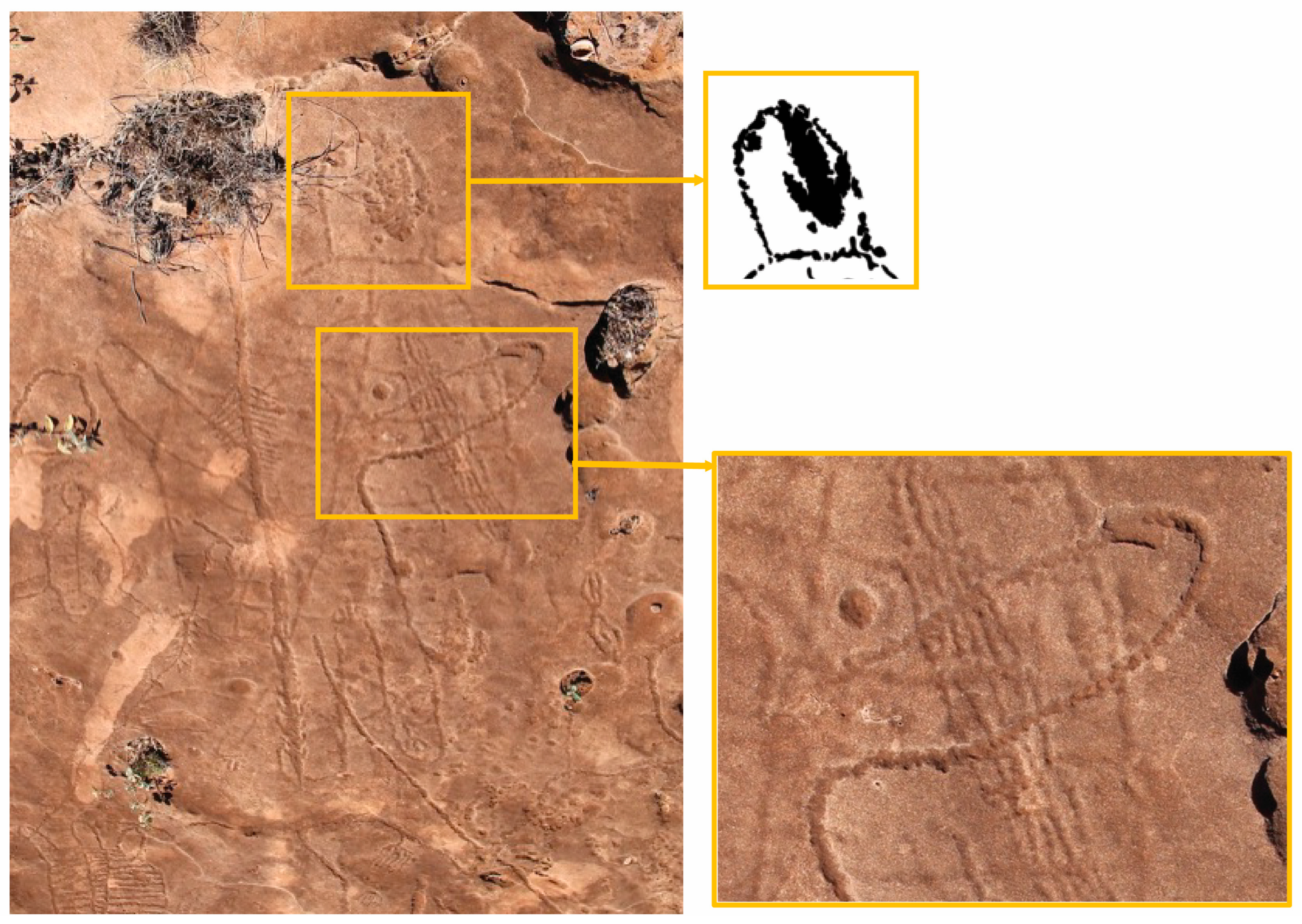
The Marapikurrinya limestone has been described elsewhere as a carpet—the low elevation and largely horizontal nature of this surface means that you can walk over these engraved panels and experience them from above. In understanding this engraved surface and the stories it shares, using the style sequence as presented above, we can see a distinct change in perspective, from viewing marine fauna as if from above the water to the solidification into rock that has been imprinted by many different terrestrial animals, with many examples of direct superimposition of say an emu foot over a turtle’s head Consequently, the number of track motifs is interesting from a narrative sense, as proposed by researchers such as Clegg (1987), Rosenfeld (2002) and Dobrez (2017), as they travel across these large canvases linking up with other motifs. Our understanding of the surface of these rocks’ mirrors much softer surfaces—as if recording the literal travels of key animals, or in some instances, found in isolation and not part of a moving sequence.
Macropod, bird, human, dingo, lizard, and insect tracks were all identified across SWC4 and MK3, and in addition, McCarthy recorded echidna tracks around the ‘Two Mile Ridge’ site, which sits within the modern-day Port Hedland township. As introduced above, tracks were single, paired, and in scenes suggesting movement, as well as with associated motifs—for example legs and/or eggs. There is significant variation across track motifs recorded (Figure 5), both in terms of style and of probable species variation, particularly for both macropod and bird tracks. Amongst bird tracks, there is a diverse array of both three-toed ‘terrestrial’ tracks, and four-toed waders, as to be expected in this coastal intertidal locale, and as explored by Carden (2009) bird tracks fall across a spectrum of both stylistic choice, from simplified and stylised (e.g., examples on the left), to anatomically detailed (e.g., examples on the right). In contrast with Carden, this level of abstraction appears to be linked to broader stylistics changes and decision making, rather than species level groupings. There are however many mythological narratives that feature key animals seen repeated across the track repertoire, such as emus and kangaroos (Palmer 1977). Lastly, the inclusion of dingo tracks helps to refine the date range of these engravings to the last 4000 years (Balme and O’Connor 2021).
Regarding the high frequency of superimpositions across the tidal islands SWC4 and MK3, one quarter of all motifs are in a superimposition relationship, which is significant for an engraved art body. In opposition to Clegg’s assertion that engravings repel each other and will spread out from origin points within a panel:
…when I realized that it can never have been possible to delete, or rub out engravings, to clean the blackboard of what was there already. If you tried to draw something new on top of old but still visible engravings, the old would get in the way and make it all an illegible mess. Better to move to a new area.
The calcarenite at Marapikurrinya, being relatively soft, may instead facilitate the layering of superimposed images in a way that does not erase lower engravings. What is interesting then about track motifs, is that of all motif classes recorded, they have the lowest frequency of superimposition.
It has long been recognised that it is difficult to correctly identify the order of superimposed engravings, particularly without the use of magnifying or other in situ technology (e.g., Clegg 1987; Franklin 2004; Maynard 1979). However, these arguments were built out of experience with Sydney-Hawkesbury basin sandstones, rather than the Marapikurrinya calcarenite limestones. Historically, when McCarthy suggested his pan-Australian stylistic sequence for engraved art, largely based on his research around Marapikurrinya (Port Hedland), heavy critique was levelled at him including, specifically, the ability to correctly identify the order of engraved images and the high probability of form bias, i.e., that infill motifs would always erase prior outlines or linear motifs (Clegg 1987). There may have been a series of motivations for this debate, for example—the boldness of proposing a one pan-continental model conflicts with other regional sequences, which placed linear figures as most recent (Wright 1968, 1977), and the ability to accurately diagnose engraved superimpositions, where it was argued that infill motifs would always appear to be more ‘recent’ than other forms (Clegg 1987).
However, as discussed above, the Marapikurrinya rock type allows for individual peck marks within layered engravings to be discerned (e.g., Figure 6), and it is this quality that makes superimposition analysis possible in this engraved art body, inverting the form bias proposed for engraving superimposition sequences (Harper 2017). Where old and weathered motifs lose this definition, with intersecting facets worn away (Franklin 2004; Maynard 1979), as observed more frequently at site Two Mile Ridge, engravings of the same styles on SWC4 and MK3 are largely unweathered in comparison. Previous research on the impacts of construction around the Port Hedland township have been conducted (Atkins 1990), which may be exacerbating this perceived difference.
In confidence with the proposed sequence and distinctness of these engraved superimpositions, patterns can be seen as to when track motifs become dominant at Marapikurrinya: in the two later styles, the Linear Schematised and Infill Naturalistic. The earliest identified style has been argued as being linked to sea-level stabilisation in the region based on the dominance of marine fauna and seascape themes (e.g., fishing boomerangs) within the earliest rock art, and identity marking behaviours inferred (Harper 2017; McDonald and Harper 2016; Tindale 1974). There is a single outline bird track present in this early style. The Linear Schematised repertoire sees the increased dominance of bird and macropod tracks, alongside anthropomorphs and spears. This style is efficient and appears to utilise iconic symbols to communicate. Following this, in the Infill Naturalistic style, the time-cost of engravings increases, with regular use of intaglio infill, anatomical detail, and a combination of coastal and terrestrial themes in the figurative component, including lizards, snakes, and crabs. There is a large track component in this style which is dominated by birds—again with liminality suggested with intertidal species, as well as terrestrial birds including emu and a variety of macropod tracks.
In comparison with Murujuga, which lies approximately 275 km southwest along the Pilbara coastline, Mulvaney’s ongoing research has recorded that tracks comprise approximately 10% of the engraving assemblage (Mulvaney 2015). Mulvaney’s analysis of 5650 motifs recorded that roughly half of these tracks are linear, and 35% are infill or solid, with small proportions of outline and patterned motifs. Additionally, when looking at change through time, there are distinct changes in size and anatomical detail, with a focus on wader birds and turtle tracks in the more recent phases of his sequence. Mulvaney (2015) identified various marine and terrestrial figurative fauna in his analysis, and from sites across Murujuga, there is variation in the frequency of marine, terrestrial, and track motifs. The most common motifs recorded were turtles and macropods—a pattern not seen at Marapikurrinya. Another pattern observed is that marine motifs dominate sites along the current coastline—particularly crustacean motifs (like at Marapikurrinya), with a few exceptions that may be geology related—and places like Murujuga, where it is argued that engravings have been made over a long period of time (Mulvaney 2015).
The change through time in Marapikurrinya rock art tells a distinctive story about identity signalling, with the extensive track repertoire playing a key role in our understanding of social coordination in the recent past. With a change in motif preference dominance from figurative marine fauna to terrestrial track motifs, one interpretation is that the meaning of the rock surface (Bradley 1997) has changed from water, where turtles, stingrays and other marine fauna of the Outline/Patterned Figurative style are observed from a birds eye view, into solidified land, with tracks left behind as symbols and traces of animals walking across it in the Infill Naturalistic style. Additionally, when put into context of changing sea levels in the region, with these identified styles being extrapolated to match social and environmental changes, it is argued that these styles function to firstly assert localised exclusive seascape identity; and through time, to become an inclusive regionally broad arid-zone identity, where tracks feature as the major information signaller.
Further questions to be developed are how the rich body of heterogeneous patterned material culture engravings, which fall within this first style, fit within this marking strategy, and what role Marapikurrinya played regionally at the time these engravings were being made (see McDonald and Harper 2016).
Contextualising this recent track focus within an Australian arid-zone context, following arguments developed by Dobrez (2017), there may be a conspicuous connection between geometric and track motifs, due to their frequent co-occurrence, as discussed above in reference to the Panaramitee. The conception of tracks, in comparison with ‘figurative’ motifs, has been suggested to represent traces left behind by objects in the world (Strehlow [1964] in Dobrez (2017)), where the plane of perspective is altered. In considering Rosenfeld’s (2002) work with communities across arid-zone Australia, we may need to consider that track scenes and individual tracks, or specific placement of tracks, need to be treated separately—and that the latter fit more neatly within Munn’s work on iconicity of track motifs. We see this amongst Marapikurrinya rock art in the most recent phase where deliberate superimpositioning of intaglio emu tracks are found over older turtle engravings (e.g., Figure 6), stamping an arid-zone marking system over and in combination with the local seascape identity.

4. Conclusions

There is stylistic and temporal variability in the Marapikurrinya engravings, from a seascape to a hybrid coastal/arid-zone system (Veth, Hook and Ditchfield). The more recent styles identified here emphasise arid-zone and coastal themes, indicating connections with the broader terrestrial Pilbara, as well as coastal/intertidal liminal themes. Together, these suggest resource hybridity, and potential seasonality, and infers regional homogeneity and social cohesion—or at least looks at the broader Kariyarra language bloc, which covers a large section of the arid Abydos Plain. The change in themes in the rock art styles changes the direction of focus, from the near sea, to the broader inland landscape, and this change can also be interpreted as changing the perception around the quality of the limestone surface on which the engravings are located: the Outline style shows marine fauna as if from above and looking through the surface of the water; the rock then solidifies through the styles with instead the marks left by terrestrial fauna imprinted onto a solid surface, again as from above, but looking onto the solid earth.
The change in vocabulary between the styles, from more figurative representations of animals and objects, to predominantly track motifs and more iconic imagery, is utilised here to signal a change in the kind of group identity being signalled: from a localised, exclusive seascape identity, to a regional inclusive coastal and arid-zone identity, using the track vocabulary to confirm social cohesion and reinforce the arid-zone and terrestrial features of this cultural group. This change is mirrored in a decrease in superimposition, making this track vocabulary more visible (with the notable exception of large intaglio tracks made over marine fauna in conspicuous locations, e.g., a turtle’s head), enhancing the active nature of this identity marking. The persistence of tracks as a marking system has pertinent links to multivocality of these iconic images—and the ability the layer meanings within them, whilst having distinct real-world referents to outsiders: we see the emu track and can link it with emu business. Further work untangling these narratives in sync with songlines and other cultural behaviours will build up a more complex understanding of this use of rock art as a distinct identity-making and -marking behaviour. In this way, the track repertoire within the Marapikurrinya engraving corpus provides a key example of the role tracks can play in communicating key information around group identity and likely narratives, independent of other rock art classes, from deep time into the recent past.

Funding

This research was funded by an Australian Postgraduate Award scholarship, and BHPBIO direct funding.

Institutional Review Board Statement

This research was undertaken with UWA Human Ethics approval RA/4/1/6418, 17 March 2014.

Informed Consent Statement

Not applicable.

Data Availability Statement

The data presented in this study are available on request from the corresponding author due to ICIP considerations, with additional consultation with Kariyarra required.

Acknowledgments

I acknowledge Kariyarra as Traditional Owners of their Country, and this body of cultural material, and thank them for their involvement and support.

Conflicts of Interest

The author confirmed there is no conflict of interest.

References

  1. Atkins, Lee. 1990. Two Mile Ridge Rock Engraving Site Port Hedland. Canberra: AIATSIS. [Google Scholar]
  2. Balme, Jane, and Sue O’Connor. 2021. The coming of the dingo. In The Oxford Handbook of the Archaeology of Indigenous Australia and New Guinea. Edited by Ian J. McNiven and Bruno David. Oxford: Oxford University Press, pp. 361–80. [Google Scholar]
  3. Beard, John Stanley. 1975. Pilbara. Explanatory Notes and Map Sheet 5, 1:100,000 Series Vegetation Survey of Western Australia. Vegetation Series Explanatory Notes to Sheet 5. Nedlands: University of Western Australia Press. [Google Scholar]
  4. Bowdler, Sandra. 1990. The silver dollar site, Shark Bay: An interim report. Australian Aboriginal Studies 2: 60. [Google Scholar]
  5. Bradley, Richard. 1997. Death by water: Boats and footprints in the rock art of western Sweden. Oxford Journal of Archaeology 16: 315–24. [Google Scholar] [CrossRef]
  6. Carden, Natalia. 2009. Prints on the rocks: A study of the track representations from Piedra Museo locality (Southern Patagonia). Rock Art Research 26: 29–42. [Google Scholar]
  7. Clarke, John. 1978. Deterioration Analysis of Rock Art Sites Conservation of rock art. In Proceedings of the International Workshop on the Conservation of Rock Art, Perth 1977. Edited by Colin Pearson. Perth: Institute for the Conservation of Cultural Material, pp. 54–63. [Google Scholar]
  8. Clegg, John. 1987. Style and tradition at Sturt’s Meadows. World Archaeology 19: 236–55. [Google Scholar] [CrossRef]
  9. Clegg, John. 2002. Variability and Information in Rock Art. In Tempus 7: Barriers, Borders, Boundaries: Proceedings of the 2001 Australian Archaeological As Sociation Annual Conference. Edited by Sean Ulm, Catherine Westcott, Jill Reid, Annie Ross, Ian Lilley, Jonathan Prangnell and Luke Kirkwood. Brisbane: University of Queensland, pp. 101–8. [Google Scholar]
  10. Clottes, Jean. 2015. The identification of human and animal figures in European Palaeolithic art. In Animals into Art. Edited by Howard Morphy. London: Routledge. [Google Scholar]
  11. Dobrez, Patricia. 2017. From tracks to gesture-derived inscription: An Australian genealogy for’tracks and lines’ petroglyphs. Rock Art Research: The Journal of the Australian Rock Art Research Association (AURA) 34: 149–68. [Google Scholar]
  12. Dobrez, Patricia. 2018. The body as intelligent tool: The making and reading of trace and trace-derived forms in rock art. Time and Mind 11: 41–66. [Google Scholar] [CrossRef]
  13. Dortch, Joe, Jane Balme, Jo McDonald, Kate Morse, Sue O’connor, and Peter Veth. 2019. Settling the West: 50,000 years in a changing land. Journal of the Royal Society of Western Australia 102: 30–44. [Google Scholar]
  14. Edwards, Robert. 1971. Art and Aboriginal Prehistory. In Aboriginal Man and Environment in Australia. Edited by Derek John Mulvaney and Jack Golson. Canberra: Australian National University Press, pp. 356–67. [Google Scholar]
  15. Eureka Archaeological Research, Gavin Jackson P/L, and Anthropos Australia. 2007. The Report of the Salvage Test Pit Excavations of Selected Aboriginal Archaeological Sites at the Proposed Port and Load-Out Facility at Port Hedland, Pilbara Region. Unpublished report prepared for the Pilbara Native Title Service & Fortescue Metals Group Pty Ltd. [Google Scholar]
  16. Franklin, Natalie. R. 2004. Explorations in Variability in Australian Prehistoric Rock Engravings. Oxford: British Archaeological Reports. [Google Scholar]
  17. Frederick, Ursula K. 1999. At the centre of it all: Constructing contact through the rock art of Watarrka National Park, central Australia. Archaeology in Oceania 34: 132–44. [Google Scholar] [CrossRef]
  18. Green, Jennifer. 2014. Drawn from the Ground: Sound, Sign and Inscription in Central Australian sand Stories. Language, Culture and Cognition 13. Cambridge: Cambridge University Press. [Google Scholar]
  19. Gunn, Robert G., Bruno David, Jean-Jacques Delannoy, Benjamin Smith, Augustine Unghangho, Ian Waina, Leigh Douglas, Cecilia Myers, Pauline Heaney, Sven Ouzman, and et al. 2022. Superpositions and superimpositions in rock art studies: Reading the rock face at Pundawar Manbur, Kimberley, northwest Australia. Journal of Anthropological Archaeology 67: 101442. [Google Scholar] [CrossRef]
  20. Harper, Sam. 2016. Outlining the Port Hedland style: A distinctive local signature within the broader shared iconographies of the Pilbara, northwest Australia. Journal of the Anthropological Society of South Australia 40: 70–107. [Google Scholar]
  21. Harper, Sam. 2017. Inside the Outline: Understanding Inclusive and Exclusive Identity in Marapikurrinya (Port Hedland) Rock Art. Ph.D. thesis, University of Western Australia, Perth, Australia. [Google Scholar]
  22. Harrison, Rodney. 2009. The archaeology of Port Hedland coastal plain and implications for understanding the prehistory of shell mounds and middens in northwestern Australia. Archaeology in Oceania 44: 81–98. [Google Scholar] [CrossRef]
  23. Jennings, J. N. 1975. Desert dunes and estuarine fill in the Fitzroy estuary (north-western Australia). Catena 2: 215–62. [Google Scholar] [CrossRef]
  24. Kendrick, George W., and Kate Morse. 1990. Evidence of recent mangrove decline from an archaeological site in Western Australia. Australian Journal of Ecology 15: 349–53. [Google Scholar] [CrossRef]
  25. Lenssen-Erz, Tilman, Andreas Pastoors, Thorsten Uthmeier, Tsamgao Ciqae, Ui Kxunta, and Thui Thao. 2023. Animal tracks and human footprints in prehistoric hunter-gatherer rock art of the Doro! nawas mountains (Namibia), analysed by present-day indigenous tracking experts. PLoS ONE 18: e0289560. [Google Scholar] [CrossRef]
  26. Lewis, Stephen E., Craig R. Sloss, Colin V. Murray-Wallace, Colin D. Woodroffe, and Scott G. Smithers. 2013. Post-glacial sea-level changes around the Australian margin: A review. Quaternary Science Reviews 74: 115–138. [Google Scholar] [CrossRef]
  27. Maynard, Lesley. 1979. The archaeology of Australian Aboriginal art. In Exploring the visual art of Oceania: Australia, Melanesia, Micronesia and Polynesia. Edited by Sidney M. Mead. Honolulu: University Press of Hawai’I, pp. 83–110. [Google Scholar]
  28. McCarthy, Frederick D. 1962. The Rock Engravings at Port Hedland, Northwestern Australia. Berkeley: University of California, Kroeber Anthropological Society. [Google Scholar]
  29. McDonald, Jo. 2015. I must go down to the seas again: Or, what happens when the sea comes to you? Murujuga rock art as an environmental indicator for Australia’s north-west. Quaternary International 385: 124–35. [Google Scholar] [CrossRef]
  30. McDonald, Jo. 2017. Discontinuities in arid zone rock art: Graphic indicators for changing social complexity across space and through time. Journal of Anthropological Archaeology 46: 53–67. [Google Scholar] [CrossRef]
  31. McDonald, Jo. 2022. The Sydney School and the genesis of contemporary Australian rock art research. In Histories of Australian Rock Art Research. Series: Terra Australis. Canberra: ANU, pp. 43–71. [Google Scholar]
  32. McDonald, Jo, and Megan Berry. 2017. Murujua, Northwestern Australia: When Arid Hunter-Gatherers Became Coastal Foragers. The Journal of Island and Coastal Archaeology 12: 24–43. [Google Scholar] [CrossRef]
  33. McDonald, Jo, and Peter Veth. 2013. Rock art in arid landscapes: Pilbara and Western Desert petroglyphs. Australian Archaeology 77: 66–81. [Google Scholar] [CrossRef]
  34. McDonald, Jo, and Sam Harper. 2016. Identity signalling in shields: How coastal hunter-gatherers use rock art and material culture in arid and temperate Australia. Australian Archaeology 82: 123–38. [Google Scholar] [CrossRef]
  35. McDonald, Josephine, and Peter Veth. 2011. Information Exchange amongst Hunter-Gatherers of the Western Desert of Australia. In Information and Its Role in Hunter-Gatherer Bands: Ideas, Debates and Perspectives. Edited by Robert Whallon, William A. Lovis and Robert K. Hitchcock. Los Angeles: UCLA/Cotsen Institute of Archaeology Press, pp. 221–33. [Google Scholar]
  36. Mithen, Steven J. 1988. Looking and learning: Upper Palaeolithic art and information gathering. World Archaeology 19: 297–327. [Google Scholar] [CrossRef]
  37. Morse, Kate, Richard Cameron, and Wendy Reynen. 2014. A tale of three caves: New dates for Pleistocene occupation in the inland Pilbara. Australian Archaeology 79: 167–78. [Google Scholar] [CrossRef]
  38. Motta, Ana P., and Peter M. Veth. 2021. Relational ontologies and performance: Identifying humans and nonhuman animals in the rock art from north-eastern Kimberley, Australia. Journal of Anthropological Archaeology 63: 101333. [Google Scholar] [CrossRef]
  39. Mountford, Charles P. 1937. Rock paintings at Windulda, Western Australia. Oceania 7: 429–35. [Google Scholar] [CrossRef]
  40. Mulvaney, Ken. 2015. Murujuga Marni: Rock Art of the Macropod Hunters and Mollusc Harvesters. Nedlands: UWA Publishing. [Google Scholar]
  41. Munn, Nancy D. 1973. Walbiri Iconography: Graphic Representation and Cultural Symbolism in a Central Australian Society. Ithaca: Cornell University Press. [Google Scholar]
  42. Ouzman, Sven, Paul S. Taçon, Ken Mulvaney, and Richard Fullager. 2002. Extraordinary engraved bird track from north Australia: Extinct fauna, dreaming being and/or aesthetic masterpiece? Cambridge Archaeological Journal 12: 103–12. [Google Scholar] [CrossRef]
  43. Paling, Eric I. 2002. Assessment of Issues Relating to Acid Sulphate Soils in Port Hedland August 2002. Perth: Report to Government of Western Australia Department of Environment Regulation. [Google Scholar]
  44. Palmer, Kingsley. 1977. Myth, Ritual and Rock Art. Archaeology & Physical Anthropology in Oceania 12: 38–50. [Google Scholar]
  45. Rosenfeld, Andrée. 1991. Panaramitee, dead or alive? Aboriginal rock art styles. In Rock art and prehistory: Papers presented to Symposium G of the Aura Congress, Darwin. Edited by Paul Bahn and Andrée Rosenfeld. Oxford: Oxbow Books, pp. 136–44. [Google Scholar]
  46. Rosenfeld, Andrée. 2002. Rock-Art as an Indicator of Changing Social Geographies in Central Australia. In Marking and Making Place. Edited by Bruno David and Meredith Wilson. London: Routledge, pp. 61–78. [Google Scholar]
  47. Schaafsma, Polly. 2015. Supper or Symbol: Roadrunner tracks in southwest art and ritual. In Animals into Art. Edited by Howard Morphy. London: Routledge, pp. 262–79. [Google Scholar]
  48. Semeniuk, V. 1996. Coastal forms and Quaternary processes along the arid Pilbara coast of northwestern Australia. Palaeogeography, Palaeoclimatology, Palaeoecology 123: 49–84. [Google Scholar] [CrossRef]
  49. Semeniuk, V., and D. P. Johnson. 1982. Recent and Pleistocene beach/dune sequences, Western Australia. Sedimentary Geology 32: 301–28. [Google Scholar] [CrossRef]
  50. Slack, Michael, Boone Law, and Luke Gliganic. 2018. Pleistocene settlement of the eastern Hamersley Plateau: A regional study of 22 rock-shelter sites. Archaeology in Oceania 53: 191–204. [Google Scholar] [CrossRef]
  51. Slack, Michael J., W. Boone Law, Adelle C. Coster, Kane Ditchfield, Judith Field, Jillian Garvey, and Puutu Kunti Kurrama. 2024. A 47,000 year archaeological and palaeoenvironmental record from Juukan 2 rockshelter on the western Hamersley Plateau of the Pilbara region, Western Australia. Quaternary Science Reviews 338: 108823. [Google Scholar] [CrossRef]
  52. Sullivan, Marjorie, Philip Hughes, and Anthony Barham. 2011. Changing Perspectives in Australian Archaeology, part II. Abydos Plain—Equivocal archaeology. Technical Reports of the Australian Museum 23: 7–29. [Google Scholar] [CrossRef]
  53. Tindale, Norman B. 1974. Aboriginal Tribes of Australia. Berkeley: University of California Press. [Google Scholar]
  54. Veitch, B. 1999. Shell middens on the Mitchell Plateau: A reflection of a wider phenomenon. In Australia Coastal Archaeology. Edited by Jay Hall and Ian J. McNiven. Canberra: ANH Publications, pp. 51–64. [Google Scholar]
  55. Veth, Peter, K. Ditchfield, and Fiona Hook. 2014. Maritime deserts of the Australian northwest. Australian Archaeology 79: 156–66. [Google Scholar] [CrossRef]
  56. Walker, Nick. 1996. In the footsteps of the ancestors: The Matsieng creation site in Botswana. The South African Archaeological Bulletin 52: 95–104. [Google Scholar] [CrossRef]
  57. Warren, L. 1995. A report of a preliminary archaeological survey of proposed hot briquetted iron quarry areas on Boodarie Station, near Port Hedland, W.A. An unpublished report prepared for BHP Billiton. [Google Scholar]
  58. Williams, Alan N., Sean Ulm, Chris S. Turney, David Rohde, and Gentry White. 2015. Holocene demographic changes and the emergence of complex societies in prehistoric Australia. PLoS ONE 10: e0128661. [Google Scholar] [CrossRef]
  59. Woodroffe, Colin D., B. G. Thom, and John Chappell. 1985. Development of widespread mangrove swamps in mid-Holocene times in northern Australia. Nature 317: 711–13. [Google Scholar] [CrossRef]
  60. Wright, Bruce J. 1968. Rock Art of the Pilbara region, North-West Australia. Canberra: Australian Institute of Aboriginal Studies, Vol. 11. [Google Scholar]
  61. Wright, Bruce J. 1977. Schematisation in the rock engravings of north-western Australia. In Form in Indigenous Art: Schematisation in the Art of Aboriginal Australia and Prehistoric Europe. Edited by Peter J. Ucko. Canberra: Australian Institute of Aboriginal Studies, pp. 110–18. [Google Scholar]
  62. Young, M. Jane. 1985. Images of power and the power of images: The significance of rock art for contemporary Zunis. The Journal of American Folklore 98: 3–48. [Google Scholar] [CrossRef]
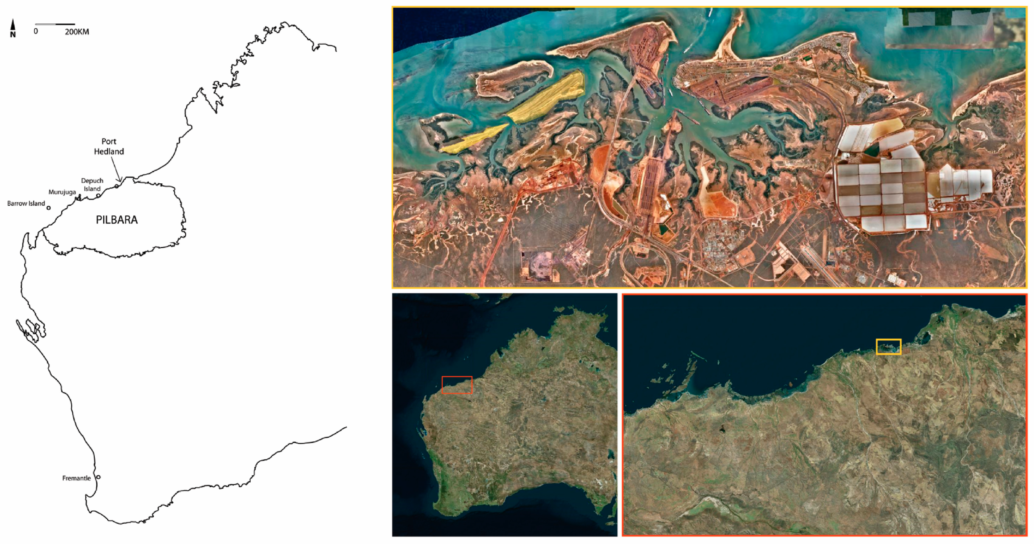
Figure 1. Marapikurrinya location: Left: Western Australia and Pilbara; right: Aerial imagery of Marapikurrinya harbour, with key study areas identified in yellow (Basemap: Nearmap—UWA licence).
Arts 14 00123 g001
Figure 2. Map of the Pilbara with language groups (grey) and key engraving provinces (black), adapted from McDonald and Veth (2013), from Tindale (1974).
Arts 14 00123 g002
Figure 3. General location of recorded figurative emu, macropod, and turtle engravings and track engravings: icon size provides relative frequencies (Base image: Wright 1968).
Arts 14 00123 g003
Figure 4. Marapikurrinya Styles (1: Outline/Patterned Figurative; 2: Linear Schematised; 3: Infill Naturalistic).
Arts 14 00123 g004
Figure 5. Marapikurrinya track variation with most common bird and macropod tracks indicated (orange circle ≥ 250; blue circle ≥ 100; green circle ≥ 50).
Arts 14 00123 g005
Figure 6. Example of multiple superimpositions where individual peck marks allow for order of superpositions to be determined, with turtle and track superimposition (top right).
Arts 14 00123 g006
Table 1. Summary of rock art style, time, climate, and track variability.
Rock Art StyleProposed Age-Range EstimatesClimatic ContextTracks (Figure 4)
Outlined/Patterned Figurative~7–5000 yaHolocene climatic optimum and sea-level stabilisation, Marapikurrinya becomes a seascape place—after rapid coastal shelf lossAlmost absent
Linear Schematised~5–1000 yaENSO and increasing aridity; resource stressDominated by three- and four-toed bird tracks; macropod tracks/trails; simplified, ‘quick’.
Infill Naturalistic1000 ya–presentClimatic amelioration, increasing ritual exchange with arid zone and desertArray of animals with terrestrial and intertidal birds, noticeable emu tracks; macropods (including array of postures/scenes); dingo, increase in track superimpositions
Disclaimer/Publisher’s Note: The statements, opinions and data contained in all publications are solely those of the individual author(s) and contributor(s) and not of MDPI and/or the editor(s). MDPI and/or the editor(s) disclaim responsibility for any injury to people or property resulting from any ideas, methods, instructions or products referred to in the content.