Abstract
Petroglyph motifs from 23 sites and 37 panels in northern Georgia and western North Carolina foothills and mountains are analyzed within their archaeological, ethnographic, and landscape contexts. The Track Rock Tradition comprises 10 chronologically sequenced marking categories: (1) Cupules/Meanders/Open Circles; (2) Soapstone Extraction cars; (3) Vulva Shapes; (4) Figures; (5) Feet/Hands/Tracks; (6) Nested Circles; (7) Cross-in-Circles; (8) Spirals; (9) Straight Lines; and (10) Thin Incised Lines. Dating spans approximately 3800 years. Early cupules and meanders predate 3000 years ago, truncated by Late Archaic soapstone extraction. Woodland period (3000–1050 years ago) motifs include vulva shapes, figures, feet, tracks, and hands. Early Mississippian concentric circles date to 1050–600 years ago, while Middle Mississippian cross-in-circles span 600–350 years ago. Late Mississippian spirals (350–200 years ago) and post-contact metal tool incisions represent the most recent phases. The Track Rock Tradition differs from western Trapp and eastern Hagood Mill traditions. Given the spatial overlap with Iroquoian-speaking Cherokee territory, motifs are interpreted through Cherokee beliefs, supplemented by related Muskogean Creek ethnography. In Cherokee cosmology, the matrilocal Thunderers hierarchy includes the Female Sun/Male Moon, Selu (Corn Mother)/Kanati (Lucky Hunter), Medicine Woman/Judaculla (Master of Game), and Little People families. Ritual practitioners served as intermediaries between physical and spirit realms through purification, fasting, body scratching, and rock pecking. Meanders represent trails, rivers, and lightning. Cupules and lines emphasize the turtle appearance of certain rocks. Vulva shapes relate to fertility, while tracks connect to life-giving abilities. Concentric circles denote townhouses; cross-in-circles and spirals represent central fires. The tradition shows continuity in core beliefs despite shifting emphases from hunting (Woodland) to corn cultivation (Mississippian), with petroglyphs serving as necessary waypoints for spiritual supplicants.
1. Introduction
This paper contains information compiled over three decades of repeatedly recording Native American petroglyphs and reevaluating relevant Native American accounts. It focuses on 23 sites and 37 panels featuring stylistically related petroglyphs in the foothills and mountains of north-central Georgia and western North Carolina (Figure 1). Of the 23 petroglyph sites, the Track Rock Gap petroglyph site in far northern Georgia contains the most panels (n = 8) (Figure 2), the broadest range of motif categories (n = 9), and the most intricate motif overlap sequence. Since the Track Rock site shares motifs and an overall stylistic sequence with the other 22 petroglyph sites in the region, the 23 sites together are the Track Rock Tradition. Track Rock Tradition petroglyphs cover an area measuring 300 km from the northeast to the southwest by 100 km from the northwest to the southeast (see Figure 1). Considering that this paper presents the first formal identification, delineation, seriation, and interpretation of the Track Rock Tradition, the paper is longer than normal as it includes supporting evidence, both archaeological and ethnographic.
Individual sites include anything from one panel to eight panels. For descriptive and analytical purposes, a panel is a single uniform surface defined by recognizable edges. Within the region studied, panels almost always occur on separate boulders, except for Silver City Rock, where two panels are on opposite sides of the same boulder. As far as can be ascertained, the recorded sample includes virtually all known unmovable petroglyphs in the region, except for Sunrise Road Rock. This boulder lies within a heavily guarded private property with restricted access. Relatively smaller and lighter movable, or portable, rocks found in the southeastern United States are excluded (e.g., Charles 2010, p. 55). The primary reason for this exclusion is the fixed nature of unmovable rocks on the landscape, which minimizes assumptions regarding the original context and landscape setting (Whitley 2005, p. 3).
Figure 1 shows the overall northeast-to-southwest alignment of the petroglyph sites following the general trend of the Blue Ridge Mountains and Piedmont foothills. Upon closer examination, the petroglyphs align with the major drainage systems. Taking heed of the cautionary note by (Stoffle et al. 2000, p. 41) that “many anthropologists studying…objects, places, and landscapes look for cultural meanings in the style of rock art, instead of where it was placed…and the meaning of rivers, instead of the power inherent in running water,” this paper explores meaning alongside the significance and use of places as evidenced in Southeastern Native American beliefs and practices. From a performance theory perspective, if the views informing Native Americans’ reciprocal interactions with petroglyph surfaces are recurrent, then the functional repercussions of the interactions become apparent; the repetition of ritualized behaviors, or performances, adds to their efficacy (e.g., Witelson 2023).

Figure 1.
Relief map showing the distribution of the petroglyph sites mentioned in the text.
Figure 1.
Relief map showing the distribution of the petroglyph sites mentioned in the text.


Figure 2.
Map of the track rock petroglyph complex.
Figure 2.
Map of the track rock petroglyph complex.

Although information regarding meaning, which can be both polysemic (a single thing with multiple related meanings) and multivalent (different things can share a single meaning), is lost, sufficient traces have survived to allow interpretation. Applying archaeological systematics to reconstruct a relative sequence of petroglyphs and consulting the ethnographic record for Native American interpretations of and interactions with petroglyph rocks, the following three major themes are explored in this paper: the relationship between chronological change and the ongoing significance of petroglyph motifs among Native Americans; the relationship between petroglyphs along river drainages and distant mountains; and the relationship between widely separate petroglyph sites.
The heavy reliance of this paper on Cherokee and Creek ethnohistory and ethnography may be questioned by those who argue that many aspects have changed since the petroglyphs were created and/or that Native American perceptions of the petroglyphs have undergone significant shifts over time. Archaeologists and ethnographers have countered such arguments for several reasons. First, Native Americans’ prioritization of cyclical time over linear time ensures a core of continuity during times of change (e.g., Moore 1994). Secondly, when outside groups settle in a new area, they tend to adopt the sacred geography of their predecessors, as shown, for example, by the research of Sundstrom (1996) in the Black Hills where the most recent Lakota occupants’ beliefs regarding the landscape mirror those of the preceding Cheyenne, Kiowas, and Kiowa Apache. Thirdly, the addition of petroglyphs on the same panels over millennia, incorporating older motifs into more recent ones, suggests a continuity of core beliefs and concerns. Since the Cherokees and Creeks had been long-standing inhabitants of the region when Europeans first arrived, and an archaeological record suggests a core of continuity within a veneer of change, these communities are a valid and reliable source of information.
Federal, State, and County officials have facilitated my contacts with Cherokee and Creek Native Americans to record, condition-assess, clean, and interpret petroglyph sites under their jurisdiction. I combined information from Native American sources with the ethnohistorical and ethnographic literature, as well as archaeological contexts.
Paper Layout
The paper presents a dialectical approach, beginning with the archaeological thesis of changing motif categories over linear time, followed by an ethnographically informed antithesis of recurring beliefs and actions in cyclical time, and finally, by synthesizing the linear and cyclical perspectives. In this regard, Taçon and Chippindale (1998) distinguish between formal archaeological techniques and informed ethnographic interpretations. Among archaeologists, formal equals an etic approach, whereas informed implies an emic one; economic anthropologists, on the other hand, distinguish between formal and substantive analyses. Such distinctions are not absolute, however, as all formal archaeological analyses are informed by what European-influenced archaeologists perceive as relevant units of observation. In contrast, formal archaeological frameworks of the past dictate informed ethnographic interpretations (Smith and Blundell 2004). Regardless of these issues, the inevitable selective and analogical mindset of archaeologists working with the past is a heuristic attempt to create a semblance of understandable order of an ostensibly fractal record. I have deliberately included details in this paper that might appear superfluous, intended for readers unfamiliar with the region, its petroglyphs, and the people associated with the petroglyphs. This paper aims to present sufficient textual and graphical evidence for others to critically evaluate and potentially utilize what they deem trustworthy and relevant information for future research.
2. Formal Thesis: Archaeological and Historical Contexts
Broad similarities in Late Mississippian, or Lamar, ceramics and inter-and intra-site layouts transcended linguistic and cultural boundaries between Native Americans who once inhabited the entire southeastern woodland region in what is now known as Georgia, eastern Alabama, southeastern Tennessee, northern Florida, western South Carolina, and western North Carolina (e.g., Williams and Shapiro 1990, p. 5). Nonetheless, extensive cultural resource management (CRM) excavations have revealed noticeable regional idiosyncrasies within this pan-regional spread. Due to the wide-ranging socio-economic, marriage, and ritual interactions between communities and individuals, the town-centered Lamar polities, which are often widely separate, resemble each other in many ways. Archaeological evidence indicates that Lamar ceramics, such as those found at late precontact and early post-contact period sites in the vicinity of the petroglyph under discussion, are closely related to historic Cherokee and Creek ceramic traditions (e.g., Rodning 2008). Motifs found on Middle Mississippian ceramics (AD 1200–1350) in northern Georgia date back to the Late Woodland period (AD 500–1000), notably, nested circles and cross-in-circles (Wauchope 1966). Spiral motifs, both stamped and incised, are common on Late Mississippian ceramics (AD 1350–1830) of the region. Rodning (2008, p. 39) traces Lamar-looking Qualla vessels in the Cherokee heartland of western North Carolina to much earlier Mississippian ceramics, such as those found at Wilbanks, Savannah, and Etowah in northern Georgia. These ceramics are more closely associated with Muskogee-speaking Creek communities. With the apparent Creek abandonment of northwest Georgia in the late 1400s and early 1500s, it is likely that these refugees settled in the Blue Ridge Mountains of North Carolina and intermarried with the Cherokee makers of earlier Pisgah and Catawba ceramics. That at least some Muskogee-speaking Creeks once lived in areas historically occupied by Cherokees can be seen in Muskogee place and river names, such as Coosa Town in the upper Nottely River catchment near the Track Rock Gap petroglyphs, the Chattahoochee River (Marked Rock River) and Suwanee Creek near the Hickorynut Mountain petroglyphs, and Coweeta Town near the Turkey Track Rock petroglyphs (Mooney 1900, p. 383).
The permeability and shifting of ethno-linguistic boundaries in the region are demonstrated by a letter dating to 1826, for example, in which John Payne refers to an old Native American custom of changing the names of specific towns. The letter describes how, depending on changing demographics and political fortunes, the Cherokee town of Echota was renamed Occhays by the Creeks and then reverted to Echota again by the Cherokees (Hicks 1826). Based on archaeological and ethnographic information, it is mainly among the Cherokee and Creek groups that we should look for as the creators of the petroglyphs. But more specifically, bearing in mind that the post-contact distribution of Iroquoian-speaking Cherokees, such as indicated on a map by Moseley (1733) which labels this portion of the Appalachian Mountains as the “Cherokee Mountains,” most closely coincides with the distribution of Track Rock Tradition petroglyphs (Figure 3), it is perhaps not surprising that Cherokees mention and interact with the petroglyphs more often than any other southeastern Native American group. But as can be seen in Figure 3, predominantly Muskogee Creek communities occupied the foothills immediately south of the Cherokee Mountains, and their settlements overlapped with those of the Cherokees. Accordingly, the traditions of the Muskogee and other neighboring groups, such as the Chickasaw, are also applicable in better understanding the petroglyphs.
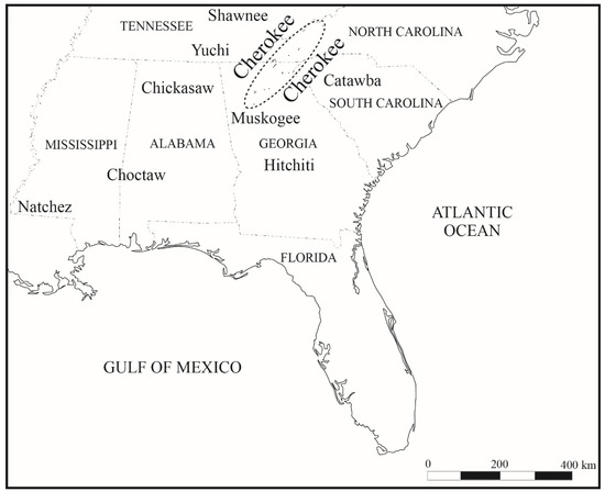
Figure 3.
Map of the southeastern United States showing the overlap between the Cherokees and the petroglyphs (petroglyph sites are dots).
Mooney (1900, pp. 234–35, 452) suggests that the various Cherokee, Creek, Catawba, Uchee, and Natchez towns shared certain beliefs and rituals due to constant trade and other long-distance interactions between these communities. On a fundamental social and subsistence level, all these communities were matrilineal and matrilocal, focused on the cultivation of domesticated corn, beans, and squash, supplemented by hunting game and gathering plant foods.
The Cherokees, also known as Ani-Yun Wiya (Real People), spoke several dialects of a common Iroquoian language; however, they lacked unified political authority. The de Soto and Prado entradas of the mid-16th century encountered people who spoke Cherokee (Hudson 1997). In 1674, a trader on the South Carolina coast, Henry Woodward, mentions the “Chorakae” as suppliers of deer hide from the interior (Hatley 1993, p. 17). At least since the early contact period, drainage segments divided Cherokee polities into separate matrilocal-centered towns and associated farmsteads, almost all located along the bottoms of fertile river valleys. Smaller farmsteads that fell within the same drainage segment as the main town often bore the same name and shared architectural features with the main town, but on a smaller scale. For example, a winter house would be a scaled-down version of a townhouse, and a summer house would resemble a square ground. When viewed clockwise from the north, post-contact town-centered areas included the Overhill Towns along the lower Little Tennessee River west of the mountains, the Out Towns along the Tuckaseegee and Oconaluftee River near the center of the mountains, the Middle Towns along the upper Little Tennessee River drainage, the Lower Towns in the headwaters of the Savannah and Chattahoochee Rivers, and the Valley Towns along the upper Hiwassee River.
The recording of the 23 petroglyph sites with 37 panels adds details to the ethnographic accounts outlined below; ethnographic “musculature” is arranged according to an archaeological “skeletal frame”.
3. Formal Thesis: Recording Methods and Results
As much as possible, the information in this paper is presented graphically, considering that petroglyphs are a graphic medium that needs assessment both visually and textually (details on recording methods and results appear in the Supplementary Materials at the end of this paper). To obtain a thorough, robust, and reliable graphic record of all the petroglyphs encountered, a variety of recording techniques was used (Table S1). Also, whenever possible, recording of the same panel was repeated during different times of the day and year. The reason for repeated recording is that, viewed and recorded in direct midday light or when soaked immediately after rains, many petroglyphs become hardly visible or completely invisible. Raking light early in the mornings and the afternoons, especially during spring and fall, renders the petroglyphs the most visible. Slightly damp surfaces with a shallow layer of reflective water pooling in the pecked, carved, and incised areas also aid in the identification and recording of some petroglyphs. Native American accounts discussed in this paper suggest that the changing visibility of petroglyphs during periods of light and moisture fluctuations is a fitting physical manifestation of how Native Americans view and approach them.
The hardness of the rocks facilitated the petroglyphs’ survival. All the recorded rocks with petroglyphs are metamorphic in origin (Table S2). Of the 23 recorded sites, most are soapstone (n = 9, 39%), followed by quartzite (n = 4, 17%), various gneisses (n = 4, 17%), schist (n = 2, 9%), fine textured metasiltstone and course grained phyllite (n = 2, 9%), and finally, amphibolite (n = 1, 4%) and slate (n = 1, 4%) (Table S2). Four of the recorded sites occur on the western end of a narrow soapstone band that completely encircles Brasstown Bald, the highest mountain in Georgia. Soapstone outcrops are also located south and northwest of Atlanta, Georgia, and in the Sylva area, western North Carolina. Contrary to conventional wisdom, there is no inextricable link between petroglyphs and soapstone quarrying for the following three reasons: Petroglyphs occur on rocks other than soapstone; most soapstone quarries contain no traces of petroglyphs (e.g., Elliott 1986; Sassaman 2006; Wells 2006), and nine petroglyph panels on soapstone contain no traces of soapstone quarrying. Moreover, soapstone panels with petroglyphs vary in shape and size (Table S2).
The recorded petroglyphs are located on three types of rock supports: bedrock, boulders, and slabs (Table S2). Bedrock is a solid rock mass that forms part of the Earth’s crust, a boulder is a large, unmovable rock that is detached or semi-detached from bedrock, and a slab is a large detached or semi-detached, flat, and relatively thin unmovable rock. As shown in Table S2, most panels are located on boulders (n = 16, 43%), followed closely by slabs (n = 15, 41%), and a few on bedrock (n = 6, 16%).
At least 13 petroglyph sites are known to be closely associated with water (Table S3). Of these, four occur within a river, one is on the edge of a river, and eight are near creeks and waterlogged areas. The rest could also have been associated with wet surfaces at one time or another, considering that ground disturbances, such as tree tip-ups and floods, can open new springheads or bury old ones. During the construction of the new walkway at Judaculla Rock, for example, an old spring, previously covered by colluvial wash, was exposed on its western side. Before its exposure, surplus rainwater pooled along the southern end of the sloping Judaculla Rock, creating a conservation problem for site managers and visitors.
When directly tracing the petroglyphs through a plastic drop cloth, the recorder assumes the bodily position and posture of Native Americans who created the petroglyphs. During tracing, it became necessary at times to stand knee-deep to waist-high in a river, crouch in a creek, or stand in a wet spring head, or on swampy ground and muddy soil. Accordingly, care had to be taken during recording to remove wet sandy clay particles from one’s shoes to avoid abrading the rock surface. The performative aspect of creating petroglyphs by standing on wet ground or within water becomes apparent when viewed in its ethnographic context.
In addition to being located close to water, there is suggestive evidence that in situ petroglyph occurrences are more common at ecotonal transitions. Due to logging and other ground disturbances, unfortunately, reliable biological evidence for this has been lost at most sites. Nonetheless, the biotite outcrop on which Hickorynut Rock is located separates thick rhododendron on its downslope side from open hardwoods upslope (Loubser 2010), while Judaculla Rock is located immediately upslope from an unusually dense stand of River Cane (Arundinaria gigantea). Cherokees who visit sites such as Judaculla Rock emphasize that the plants and animals in the vicinity require respect and should not be harmed.
4. Formal Thesis: Recorded Petroglyph Motif Classification and Sequence
4.1. Petroglyph Motif Categories
Adopting, in a modified fashion, the systematics approach of Dunnell (1971) as applied to ceramics (Huffman 1980), petroglyph motifs and associated alterations to the rock were grouped according to the following four criteria: shape, resemblance, placement alongside contemporary motifs within a direct overlap sequence, and technique of execution. The following 10 categories of pecked, carved, and incised markings occur on rock surfaces that belong to the Track Rock Tradition: (1) Cupules/Meanders/Open Circles; (2) Soapstone Extraction Scars; (3) Vulva Shapes; (4) Figures; (5) Feet/Hands/Tracks; (6) Nested Circles; (7) Cross-in-Circles; (8) Spirals; (9) Straight Lines; and (10) Thin Incised Lines. Photographic examples of these categories are presented in Figure 4, Figure 5, Figure 6, Figure 7, Figure 8, Figure 9, Figure 10, Figure 11, Figure 12 and Figure 13. Although the categories admittedly lump together motifs that exhibit internal variation, splitting them into multiple smaller sub-categories did not yield any additional insights. Where relevant, however, significant differences within categories are mentioned in this paper.
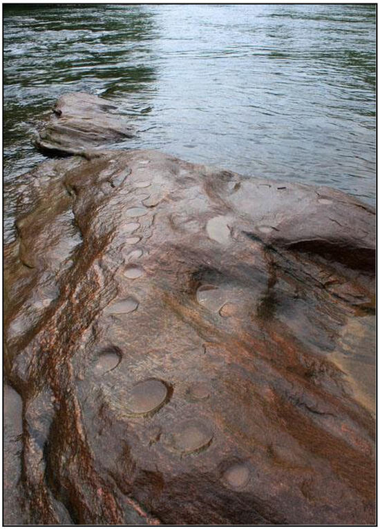
Figure 4.
Rock with cupules, Chattahoochee River (Alan Cressler).
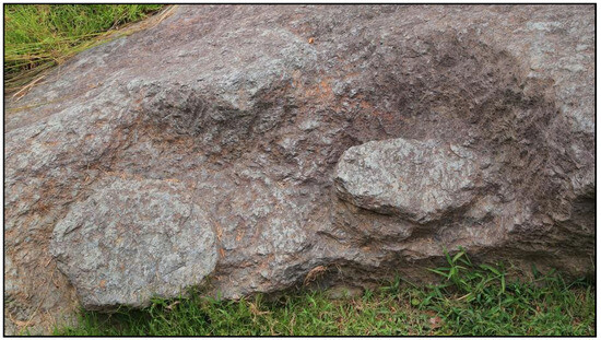
Figure 5.
Soapstone extraction pedestals, Judaculla Rock (Alan Cressler).
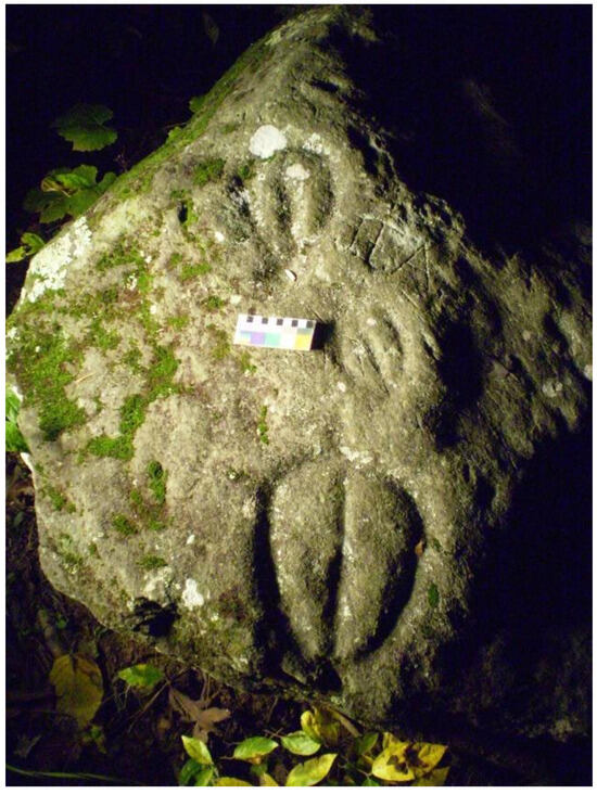
Figure 6.
Vulva shapes, Track Rock 2 (Jannie Loubser).
Figure 7.
Figure, Judaculla Rock (Alan Cressler).
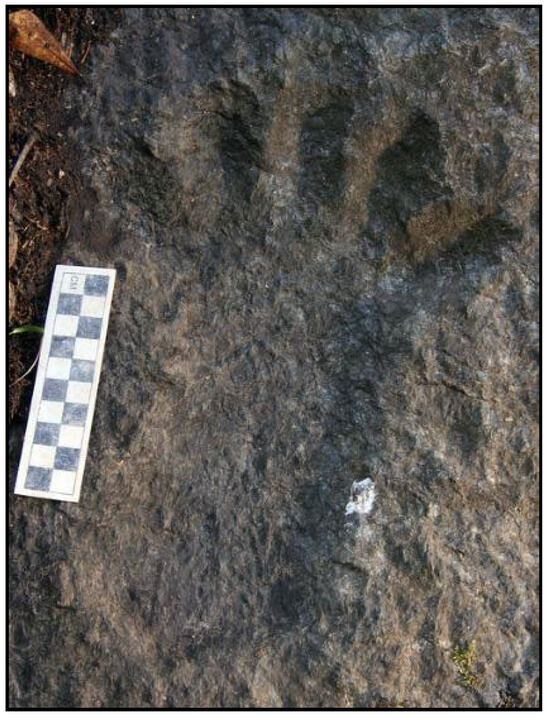
Figure 8.
Human foot, Shoal Creek (Alan Cressler).
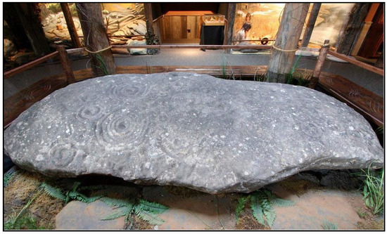
Figure 9.
Nested circles, Reinhardt Rock (Alan Cressler).
Figure 10.
Cross-in-circles on meanders, Chatuge Rock (Allen Cressler).
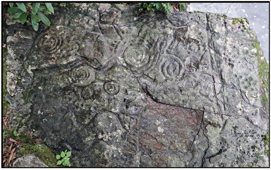
Figure 11.
Spirals, Hiwassee Fishing Rock (Alan Cressler).
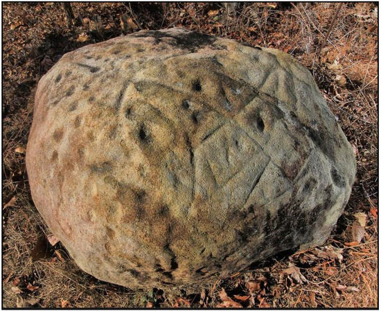
Figure 12.
Straight lines, Allen Rock (Alan Cressler).
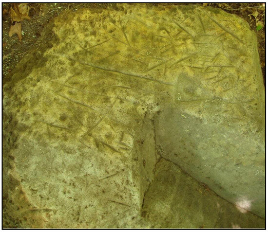
Figure 13.
Thin incised lines, Turkey Track Rock A (Lori Hansen and Scott Ashcraft).
The fact that only a few of the petroglyph motifs within the Track Rock Tradition match everyday physical things means that the identification and naming of most motifs are more for descriptive and classificatory purposes, based on what the shapes resemble, rather than implying that they are literal representations. Nonetheless, the motifs identified and interpreted by Native Americans do represent known physical things and metaphorically refer to concepts explored in the ethnographic literature, which are discussed in subsequent sections.
4.2. Petroglyph Panels Sharing Motif Categories
Excluding soapstone extraction scars, the remaining nine motif categories from 33 petroglyph panels were compared using a correspondence index based on motif category affinities between paired sites (Table 1). Presence/absence scores were calculated from the sum of common scores divided by the maximum common score (Robinson 1951). This analysis differs from the one presented in Loubser et al. (2018) in that it excludes seven petroglyph sites that fall outside the range of Track Rock Tradition motif categories.

Table 1.
Presence/absence scores of nine motif categories from 33 petroglyph panels.
Each of the motif categories chosen for comparison encompasses sub-categories. Correspondence analyses of these finer-grained categories yielded no statistically significant differences. The correspondence scores shown in Table 1 have two main shortcomings: First, panels with the broadest range of motif categories tend to have higher correspondence scores than those with fewer motif categories, and secondly, the presence of virtually identical motifs on widely separate panels is not reflected in the similarity scores. Nonetheless, specific observations are worth noting. First, petroglyph sites with 90 percent or more correspondence are not necessarily located close to each other geographically. Figure 14 shows the 11 sites (comprising 15 panels) with correspondence scores of 90% or more. The results show that widely separated petroglyph sites share high scores, such as Brinkley Rock, deep in the Blue Ridge Mountains, and River Hill in the Piedmont foothills. Based on motif categories, then, the petroglyph sites in the Georgia Piedmont cannot be said to be stylistically separate from those in the geographically distinct Blue Ridge Mountains. Secondly, except for the high correspondence between Sprayberry Rock and Reinhardt Rock in the Etowah River catchment, between River Hill and Silver City in the Etowah River Catchment, and between the Track Rock panels and Young Harris Rock in the Brasstown Creek catchment, similarity scores between sites within the same drainage catchments, such as Brinkley Rock and Judaculla Rock along the Caney Creek or the petroglyph sites along the Hiwassee River, are lower. Apart from the high similarity scores among Track Rocks 4, 5, and 6 and, separately, between Turkey Track Rocks A and B, the intra-site correspondence scores between other panels within the same petroglyph site complex are also low. Viewed overall, the correspondence results suggest a close relationship between distant sites within the Track Rock Tradition, and that nearby sites are not necessarily closely matched.
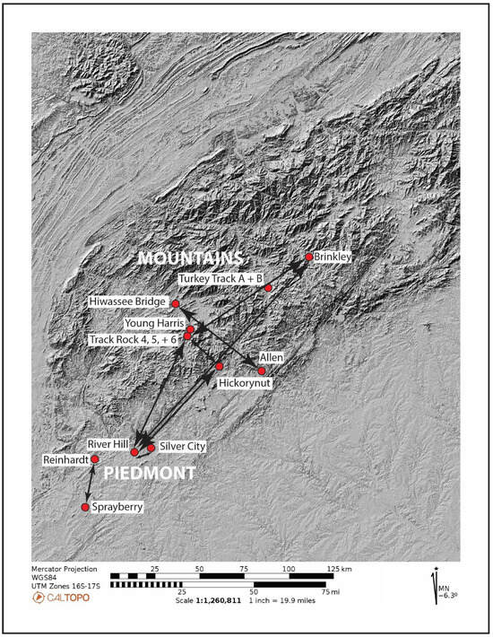
Figure 14.
Relief map showing sites with a correspondence score of ≥90%.
4.3. Defining the Outer Limits of the Track Rock Tradition
Except for cross-in-circles and long straight lines, markings reminiscent of those in the Track Rock Tradition also occur in neighboring northern Alabama and eastern Tennessee to the west, albeit in different shapes and different settings (Faulkner et al. 2004). These differences suggest that, although they are related, the petroglyphs to the west of the Track Rock Tradition are part of a separate but related tradition, which is tentatively labeled the Trapp Tradition after an elaborate petroglyph site in a northern Alabama rock shelter (Figure 15). Most noticeably, instead of cross-in-circles, northern Alabama and eastern Tennessee petroglyph sites feature a distinctive nested cross without a circle, reminiscent of motifs on Mississippian-period ceramics in the region. Northern Alabama sites feature depictions of bi-lobed Mississippian period artifacts (Henson and Martz 1979, pp. 10, 15), which are absent in the Track Rock Tradition petroglyphs. Moreover, depictions of vulva shapes in far northwestern Georgia, eastern Alabama, and eastern Tennessee differ from those in the Track Rock Tradition. And finally, Trapp Tradition petroglyphs sites include cliffs, bluffs, and rock shelters (Faulkner et al. 2004, pp. 80–87), which is not the case for Track Rock Tradition sites. East of the Track Rock Tradition, mainly in the mountains and foothills of northwestern South Carolina, petroglyphs are noticeably different, comprising various rectilinear shapes and circles (Charles 2010). The most elaborate petroglyph site in South Carolina is Hagood Mill, hence the name “Hagood Tradition” for the associated petroglyph sites in the region. South of the Chattahoochee River, the isolated outlines of arms, hands, and rayed circles, pecked and incised into boulders (Ed Lanham 2014, personal communication), differ from the solidly pecked and engraved hands of the Track Rock Tradition. The geographic spread of the outlined “Hand Tradition” to the south and west of the Chattahoochee River has not yet been determined.
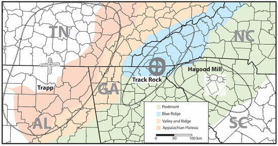
Figure 15.
Track Rock Tradition petroglyphs with Trapp and Hagood Mill Traditions.
4.4. Sequencing of Motif Categories
The following methods were used to construct the sequence of rock marking categories within the Track Rock Tradition (with AD 1950 representing the “present”): (1) identifying direct overlaps between pairs of categories within each panel and synthesizing the overlap trends between panels with direct overlaps using reduction rules; (2) comparing the degree of weathering of different categories within the same panel; (3) determining which categories occur on top or below soapstone quarrying, which is a terminal Late Archaic period horizon marker with a known date range of 3800 to 3000 years ago; (4) identifying vulva shapes, figures, feet, hands, and tracks that are sandwiched between earlier meanders and later nested circles, which are most likely Woodland period motifs dating to between 3000 and 1050 years ago; (5) identifying cross-media isomorphism date ranges (e.g., Roe 1991) based on petroglyph motifs occurring on dated ceramic styles, notably, Early Mississippian ceramics with nested circles dating to between 1050 to 600 years ago, Middle Mississippian ceramics with cross-in-circles dating to between 600 and 350 years ago, and Late Mississippian ceramics with spirals dating to between 350 and 200 years ago; and (6) identifying incisions of various shapes and sizes, mainly turkey tracks and a face, that were cut with sharp metal knives, dating between 200 years ago and the present.
The sequence was primarily constructed with the aid of Harris Diagrams for each of the 23 panels that have overlaps. Applying the following two reduction rules made it possible to construct an overall overlap sequence between panels (Harris et al. 1993; Loubser 1997; Orton 1982): (1) the transitive relationship rule and (2) the anti-symmetric relationship rule (Figure 16). The transitive relationship rule states that if Category 1 is without exception below Category 2 and Category 2 is without exception below Category 3, then Category 1 is without exception below Category 3. Category 3 is later than Category 1, even when no direct overlap was recorded between Categories 1 and 3. The anti-symmetric rule states that if Category 1 is below Category 2 in some instances but Category 2 is below Category 1 in others, then the two categories are relatively contemporary.
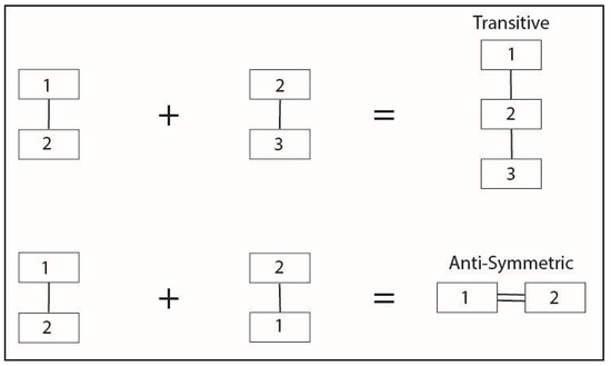
Figure 16.
Graphic representation of Harris Diagram reduction rules.
Due to evidence for a recurrent sequence of categories on 23 panels within the Track Rock Tradition, the 14 panels with shared motifs but without any noticeable overlaps between these motifs are included in the sequence. Panels with many tightly packed motifs at one stage have likely exhibited signs of overlaps, such as Hiwassee Fishing Rock. Still, the weathering of the petroglyphs makes it impossible to determine. Of the 23 panels with direct motif overlaps, Figure 17 shows seven with the most representative overlaps.
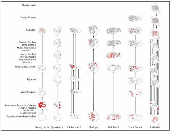
Figure 17.
Graphic summary of the most representative overlaps (the rocks are not on the same scale).
Unless evidence is found to the contrary, the overlap sequence for the Track Rock Tradition is accepted as a helpful way to order the recorded categories. The identification of motifs within each category and their interpretation in this descriptive section are primarily based on assumptions from a European archaeological perspective instead of a Native American one. The categories of motifs stratigraphically associated with the soapstone bowl extraction scars are presented in relative chronological order, starting with the earliest two: meanders and cupules.
4.5. Meanders
Meanders are depicted on 24 panels, some of which are highly fragmented and faint in appearance. The overall fainter appearance of most meanders compared with other motif categories on the same panels is evidence of their relatively early date. A few faint, tiny circles with central dots and larger, truncated circles are grouped with the meanders (Figure 18 and Figure 19). The early placement of the latter two categories is supported by a small circle with a central dot motif, which is covered by a figure on Boling Park Rock, and by a large empty circle that is truncated by a foot on Track Rock 6. Five weathered remnants of meanders are truncated by soapstone bowl extraction scars at Sprayberry Rock in the central Georgia foothills (Figure 18). These truncated weathered meanders must be older than 3000 years, which is the youngest direct AMS date for Late Archaic soapstone cooking bowls in the southeastern woodlands (Sassaman 2006).
Figure 18.
Weathered meanders truncated by soapstone scars at Sprayberry Rock.
Most meanders appear reticulated and “random”, with no discernible pattern, although two resemble incomplete cross-in-circles, one on Reinhardt Rock and the other on Track Rock 3 (Figure 19). Zigzags are present on Track Rock 3 and Squirrel Rock. The “tidy” curvilinear meanders on Silver City Rocks 1 and 2 deviate from the haphazard meanders found on other panels. The linear and parallel meanders on Hiwassee Fishing Rock also deviate from the prevailing reticulated pattern within the Track Rock Tradition and appear to be contemporary with the concentric circles and spirals on the same rock. As shown below, concentric circles and spirals are later in the overlap sequence.

Figure 19.
Petroglyph panels with meanders and tiny circles are red, gray at Hiwassee Fishing Rock is roughly contemporary, and outlines are soapstone quarry scars (scale bar = 10 cm).
Figure 19.
Petroglyph panels with meanders and tiny circles are red, gray at Hiwassee Fishing Rock is roughly contemporary, and outlines are soapstone quarry scars (scale bar = 10 cm).

Like cupules, only a few meanders predate soapstone extraction scars; the majority are most probably later, as can be seen by meander remnants pecked into a soapstone extraction scar on Track Rock 2. Unlike cupules that continue throughout the Track Rock Tradition sequence, “random” meanders are covered by subsequent vulva shapes, figures, feet/hands/tracks, nested circles, cross-in-circles, straight lines, and thinly incised lines. However, on Track Rocks 3 and 4, short sections of “random” meanders have been re-pecked over the toes of feet. The straight meanders on Hiwassee Fishing Rock and Hiwassee/Brasstown Rock are probably later too, due to their seamless attachments to later spiral motifs.
4.6. Cupules
Cupules, which are round and curved-shaped pecked and ground hollows, occur on 30 of the 37 petroglyph panels of the Track Rock Tradition. The seven petroglyph panels on which cupules are absent show signs of extreme weathering, so these could at one time have had cupules too.
Due to their geographical co-occurrence with Track Rock Tradition petroglyphs, it is worth noting that 55 boulders with cupules only (without petroglyphs, as shown in Figure 4 above) have been documented in northern Georgia and western North Carolina (Hansen 2009; Alan Cressler 2022, personal communication). Only a handful of recorded cupule sites occur outside this area, with a few occurrences in Alabama, Tennessee, and South Carolina (Figure 20). A definite cut-off point for cupule only boulders is the Chattahoochee River in the Atlanta area, with nothing to the immediate south, west, and east. This stretch of the Chattahoochee is generally considered the southernmost extent of known Cherokee towns. The close spatial fit between rocks with cupules and Cherokee towns suggests that the production and use of cupules in the region is tied to Cherokee practices.
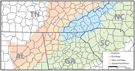
Figure 20.
Distribution of cupule-only sites by county.
Four weathered cupules are truncated by soapstone bowl extraction scars at Young Harris Rock in the mountains of far northern Georgia (Figure 21). These cupules must be older than the youngest date of soapstone extraction, which was 3000 years ago. Although a few cupules occur under meanders at Track Rock 6, Reinhardt Rock, and Judaculla Rock, cupules also occur on top of the same meanders and later motifs, including vulva shapes, figures, tracks, and nested circles.
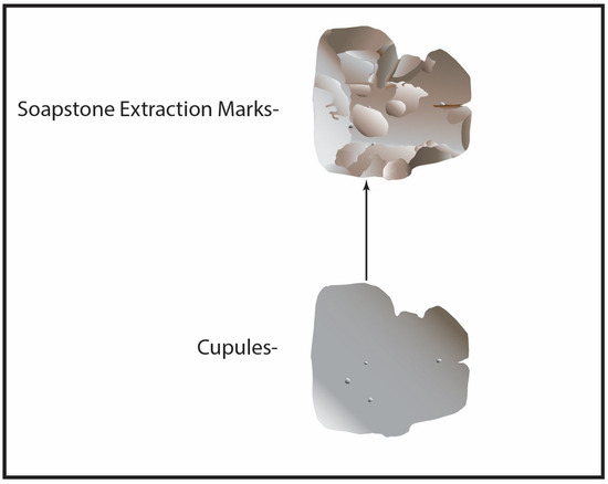
Figure 21.
Cupules truncated by soapstone scars at Young Harris Rock.
The number of cupules increases through time, with most occurring at the end of the overlap sequence (Figure 22). Relatively fresh-looking cupules are arranged linearly along the spines of Track Rock 6, Silver City Rock, Judaculla Rock, Hiwassee 5 Rock, and the Hiwassee Dogs Rock, for example. Prominent cupules are placed in the center of concentric ring motifs, while smaller ones occur in each of the four quadrants of cross-in-circle motifs at Judaculla Rock and Chatuge Rock. Cupules also form the heads of figures at Golf Course Rock, Track Rock, Judaculla Rock, Hickorynut Rock, and River Hill Rock 2. A few cupules at Judaculla Rock and Hiwassee 5 are larger than usual, while those at Hiwassee Rock 5 are noticeably smaller. The latter resembles dots instead of curved, cup-shaped objects.
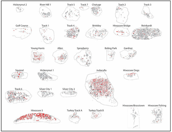
Figure 22.
Petroglyph panels with later cupules shown in red; gray is earlier, but for Hiwassee, gray is roughly contemporary (scale bar = 10 cm).
4.7. Soapstone Bowl Extraction Scars
The subsequent modification of the rock surfaces, following early cupules and meanders, are soapstone bowl extraction scars, dating to between 3800 and 3000 years ago (Sassaman 2006). Adopting the nomenclature proposed by Elliott (1986), the following four scar types can be identified on eight soapstone boulders with Track Rock Tradition petroglyphs: grooves, protruding blanks, stems/pedestals within depressions, and empty depressions. These four scar types represent successive stages in soapstone bowl production, starting with grooves that create protruding blanks, followed by the creation of a pedestal from which the blank can be knocked off. Finally, the stem is removed, leaving an empty depression. The amount of soapstone extraction varies from boulder to boulder (Figure 23). Being almost entirely covered with hollow scallops and a protruding blank, Young Harris Rock had the most soapstone removed, resembling a faceted lithic core. Stems within depressions and hollow depressions can be seen on Judaculla Rock (see Figure 5 above), Sprayberry Rock, and Quarry Rock. Grooves and stems within depressions are present at the two Turkey Track sites. Track Rock 2 has had a slab of soapstone removed, while Brinkley Rock shows a faint trace of a groove. Depending on the degree of weathering, marks created by soapstone bowl extraction tools vary from one rock to another, with striations and peck marks left by deer antlers being most noticeable at Judaculla Rock (see Figure 5 above).
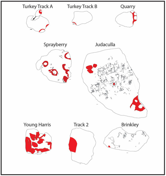
Figure 23.
Petroglyph panels with soapstone quarry scars in red; gray are earlier at Sprayberry and roughly contemporary at Judaculla and Brinkley (scale bar = 10 cm).
4.8. Vulva-Shapes
The term vulva refers to oval-, U-, and V-shaped motifs bisected by lines and/or encircling dots. Vulva-looking shapes occur at eight sites and on 13 panels (Figure 24). On all the vertically slanted rocks, the long axes of all the vulva shapes face downwards. All the vulva shapes on Track Rock 1, 2, 4, 5, and 6 and Young Harris Rock are oval-shaped. However, each of the two vulva-like motifs on Track Rock 1 has a pointed tip that resembles the tracks of a deer. The oval-shaped vulva-like motifs on Track Rock 6 feature elaborate shapes and infills, ranging from those with a rayed interior and dots to those with dots and vertical lines bisecting the oval. Four of the Track Rock 6 ovals have vertical lines extending below their lower ends, all pointing downwards to the ground below. These lines suggest fluids emanating from the ovals. A pair of open oval shapes abuts the outer edge of River Hill Rock 1. V-shaped vulva-looking motifs occur on Hickorynut 1, Squirrel, Silver City 1, and Silver City 2 Rocks. U-shaped motifs, some with interior dots, occur on Silver City 1 and Shoal Creek Rocks.
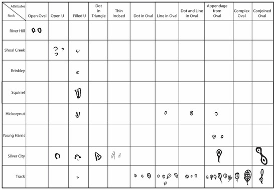
Figure 24.
Vulva-shape sub-categories by site.
A vulva shape overlaps a hollow scallop at Young Harris Rock, while two figures overlap two separate hollow scallops, one at Sprayberry Rock and the other at Judaculla Rock (Figure 25). In no instances do soapstone extraction scars truncate vulvas, figures, feet, hands, tracks, nested circles, or cross-in-circles, indicating that these motifs are probably younger than 3000 years. The overlap sequences on Track Rock 6 and Hickorynut Rock 1 show that no unidirectional motif overlap trend exists among vulvas, figures, feet, and tracks, as each of these categories is both on top and below one another. According to the anti-symmetric rule, these categories constitute a contemporary unit. Except for two feet at Track Rock that occur below re-pecked sections of meanders, all vulvas, figures, feet, tracks, and hands occur on top of meanders wherever they overlap. So, vulvas, figures, feet, tracks, and hands are more recent than both soapstone extraction scars and meanders. Of these motif categories, a foot and a hand occur below concentric circles at Reinhardt Rock. Since none of the contemporary vulvas, figures, feet, and tracks occur on top of any concentric circles, they constitute an earlier unit.
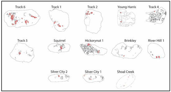
Figure 25.
Petroglyph panels with vulva shapes shown in red; gray is earlier. Soapstone Quarry scars are outlined (scale bar = 10 cm).
4.9. Tracks
Tracks, which occur on 21 panels, include human footprints, mammal tracks, deer tracks, bird tracks, and human handprints (Figure 26). Except for one human footprint on Judaculla Rock, which has its claw-like toes depicted separate from the rest of the foot, all the other human footprints have toes that are either attached or semi-attached. The toes of all human footprints that occur on upward sloping rock surfaces are pointing upwards, as if they emerge from the water or ground below (Figure 26). A series of six vertically aligned footprints at Shoal Creek Rock creates the unmistakable impression that they have emerged from Shoal Creek immediately below (Figure 27).
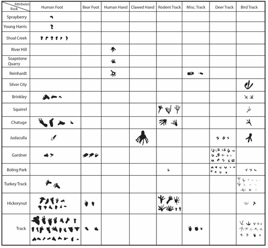
Figure 26.
Track sub-categories by site.
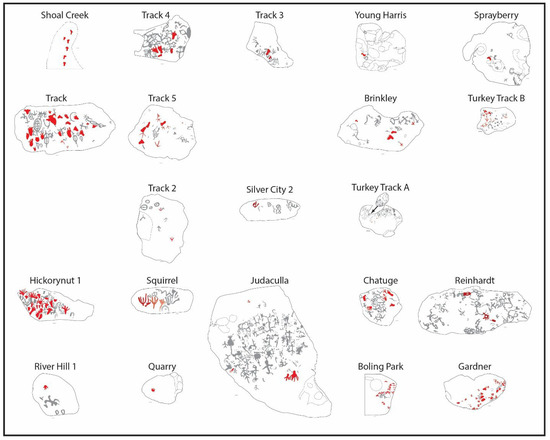
Figure 27.
Petroglyph panels with tracks shown in red; gray is earlier. Soapstone Quarry scars are outlined (scale bar = 10 cm).
Among the mammal tracks is one on Track Rock 6 that resembles a black bear’s paw print. Rodent tracks include a squirrel-looking one on Track Rock 3 and cotton rats and jumping mice on Hickorynut Rock 1 (Murie and Elbroch 2005, pp. 328–29). Like human footprints, the rodent tracks all point upwards, as if they are escaping from the ground at the base of the rock.
Multiple deer tracks on Boling Park Rock, which is near the southern limit of the Track Rock Tradition’s geographical spread, are mostly pointed, while those on Gardner Rock marking the opposite extreme northern side of the Track Rock Tradition are parallel. Unlike human footprints and rodent tracks, deer tracks are haphazardly arranged on the rock, pointing in different directions.
The bird tracks that occur on seven panels most closely resemble those of a turkey. The thinly incised tracks at the Turkey Track site differ in appearance and appear more recently made than the pecked turkey tracks on the other panels. Having been carved with sharp metal tools, the Turkey Track panels date to post-contact times. A single webbed track on Track Rock 6 could be that of a duck. An isolated trident motif on Silver City Rock 2 could represent the track of a giant bird.
In contrast, the miscellaneous track-like motifs on Squirrel Rock could represent either animal tracks or plants. While a few bird tracks point upwards, the majority face in various directions. The haphazard orientations of bird tracks resemble those of deer.
Human-looking hands are present at River Hill Rock 1 and Quarry Rock. Due to weathering, the number of digits on these two hands cannot be determined with certainty. A big hand with seven claw-like digits points obliquely downwards towards the base of Judaculla Rock. Next to this abnormally big hand is a three-toed bird-looking track. A small open circle with short radiating lines at Reinhardt Rock is reminiscent of a hand and arm attached to the solitary figure at Hiwassee Fishing Rock.
4.10. Figures
Figures, which include two dog-like motifs and two serpents with diamond-shaped heads, occur on 15 panels. Of the 30 human-looking figures, the two on the Hiwassee/Brasstown Rock are the most detailed (Figure 28). A Hiwassee/Brasstown Rock figure features an eared head and beak that resemble a bird. This bird-headed figure is the only hollow-bodied figure in the Track Rock Tradition. The human figure on the same panel has seven digits on one enlarged hand. Most figures have outstretched arms, outstretched legs, and cupules as heads. Six of these have a vertical line attached to their lower torsos, resembling a tail or exaggerated penis. A solitary figure on Hickorynut Rock 2 features downward-pointing, curvilinear arms that resemble bird wings. Each of the two figures with herringbone torsos has an atypical head; one has ears, and the other has a diamond-shaped head. A plant-looking figure on Judaculla Rock has an upper torso that resembles a datura plant’s seed pod as seen from the side (not shown in Figure 28). A figure on Sprayberry Rock has a concentric ring head. Two figures on Track Rock 6 are depicted upside-down compared to ground level. Considered together, the bird-looking head, the wing-looking arms, the “ribbed” figures with anomalous heads, the plant-like figure, and a figure with a concentric head are suggestive of bodily transformations. The two upside-down figures are also anomalous. The following two figures are merged with other seemingly contemporary motifs: One on Hiwassee Fishing Rock is part of a meander motif that touches a spiral, and the other on River Hill Rock 1 holds a rayed concentric ring in one hand. The fact that these two figures and most figures on Judaculla Rock merge with earlier meanders suggests that, despite any time differences, separate motif categories, most likely dating to different periods, are merged in several instances.
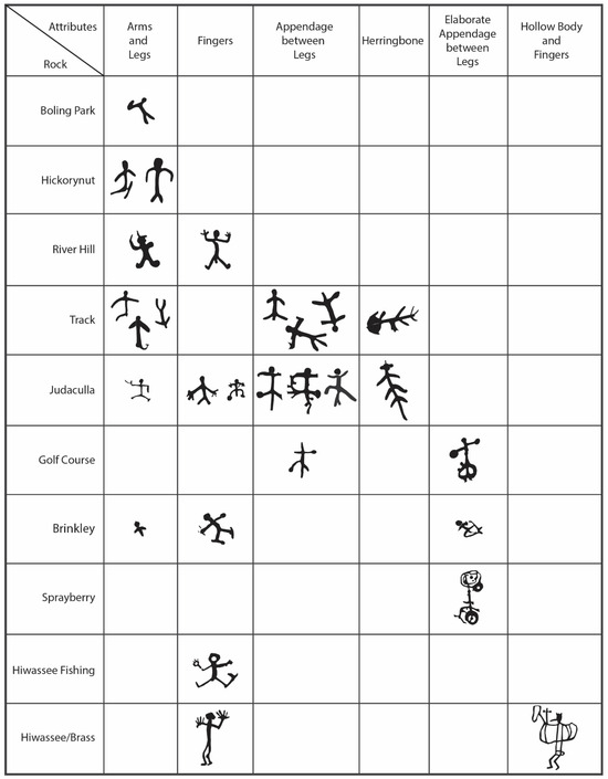
Figure 28.
Figure sub-categories by site.
However, based on similar depths, the absence of truncation or overlaps, and the degree of weathering on the same rock surface, a horned figure on River Hill Rock 1, a figure with outstretched limbs on Hiwassee Fishing Rock, and two figures on Hiwassee/Brasstown Rock are probably contemporary with the concentric circles.
Thin turkey tracks that were engraved with sharp metal implements at Turkey Track Rock A and Turkey Track Rock B are also more recent. Given the overlap evidence, then, except for four figures and the thinly incised turkey tracks, the pecked and engraved vulva, feet, track, and hand unit is sandwiched between earlier soapstone extraction scars and meanders on the one hand and later concentric circles on the other (Figure 29, Figure 30 and Figure 31). As reiterated below, being older than concentric circles implies that most figures and the feet, track, and hand unit are probably not younger than 1050 years. Also, as will be shown below, four of the more elaborate figures, all from the Hiwassee River Corridor sites, are probably more recent.
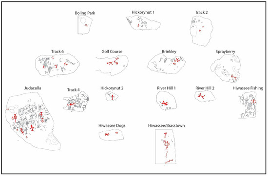
Figure 29.
Petroglyph panels with figures shown in red; gray is earlier except for the Hiwassee rocks where gray is relatively contemporary. Soapstone Quarry scars are outlined (scale bar = 10 cm).
4.11. Concentric Circles
Fourteen panels contain concentric circles. Included in this category are the following motifs: a single circle centered on a cupule, concentric circles without a central cupule, concentric circles centered on a cupule, and nested arcs forming half a circle (Figure 30).

Figure 30.
Concentric circle and spiral sub-categories by site.
Figure 30.
Concentric circle and spiral sub-categories by site.

Nested circles occur on top of meanders, soapstone extraction scars, and a figure at Sprayberry Rock, on top of meanders and a hand at Reinhardt Rock, and on top of meanders at Silver City Rocks 1 and 2 (Figure 31). A rayed concentric circle motif is associated with a horned figure at River Hill Rock 1. Nested half circles touch the edge at Reinhardt Rock and Track Rock 7, while water erosion and rock spalling have caused the concentric circles at Hiwassee Rock 5 and Hiwassee Fishing Rock to split in half. Closely juxtaposed, or paired, concentric circles occur at Reinhardt Rock, Judaculla Rock, and River Hill Rock 3. Reminiscent of the nested circles on Track Rock Tradition panels are nested circles on Early Mississippian ceramics, dating to between 1050 and 600 years ago. Based on this cross-media isomorphism, it is reasonable to propose that the Track Rock Tradition concentric circles date to this period.

Figure 31.
Petroglyph panels with concentric circles and spirals shown in red; gray is earlier except for the Hiwassee Rocks where gray is relatively contemporary. Soapstone Quarry scars are outlined (scale bar = 10 cm).
Figure 31.
Petroglyph panels with concentric circles and spirals shown in red; gray is earlier except for the Hiwassee Rocks where gray is relatively contemporary. Soapstone Quarry scars are outlined (scale bar = 10 cm).

4.12. Cross-in-Circles
Altogether, six Track Rock Tradition sites and eight panels have cross-in-circle motifs (Figure 32).
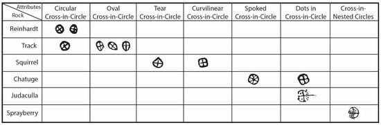
Figure 32.
Cross-in-circle sub-categories by site.
A cross-in-circle covers a concentric circle and meanders at Reinhardt Rock. Cross-in-circles cover meanders at Chatuge Rock, Squirrel Rock, Sprayberry Rock, Track Rock 3, and Track Rock 6 (Figure 33). At Track Rock 2, a short horizontal line is engraved across a bisecting vertical line of a vulva shape. This line transforms the vulva into a circle-in-cross shape. At Track Rock 3, a section of an earlier meander is transformed into a circle-in-cross shape as well. Dots occur in each of the four quadrants of a cross-in circle at both Judaculla Rock and Chatuge Rock. Chatuge Rock also has a modified cross-in-circle with an added line, resembling a five-spoked wheel.
Cross-in-circles that occur over nested circles at Reinhardt Rock are reminiscent of cross-in-circles found on Middle Mississippian Etowah ceramics in the area, dating to between 600 and 350 years ago. More specifically, a cross-in-nested circle motif placed on a soapstone extraction scar at Sprayberry Rock is identical to diagnostic cross-in-nested circle motifs found on Middle Mississippian Etowah ceramics. Taken together, the cross-media stylistic similarities and the overlap sequence support the inference that cross-in-circles postdate nested circles and most likely fall within the Middle Mississippian period.

Figure 33.
Petroglyph panels with cross-in-circles shown in red. Soapstone Quarry scars are outlined (scale bar = 10 cm).
Figure 33.
Petroglyph panels with cross-in-circles shown in red. Soapstone Quarry scars are outlined (scale bar = 10 cm).

4.13. Spirals
Spirals occur on three panels (see Figure 30 and Figure 31 above), all located along a roughly three-kilometer-long section of the Hiwassee River. This section of the river features five separate petroglyph panels, with the westernmost panel situated at the confluence of the Hiwassee River and Brasstown Creek.
The westernmost panel, labeled Hiwassee/Brasstown Rock, is three kilometers south of the Mississippian Period Peachtree Mound site. An intensive riparian survey conducted by Scott Ashcraft and Cherokee assistants (Scott Ashcraft 2000, personal communication) located no petroglyphs between the Hiwassee–Brasstown Rock and the Peachtree Mound. However, numerous exposed rock surfaces are present within the river and along its banks between the two locales.
Of interest is that spirals only occur along the four-kilometer corridor of the Hiwassee River and on no other Track Rock Tradition panel. Incised spirals are found on Ware B ceramics at the nearby Peachtree Mound site (Setzler and Jennings 1941, p. 42) and on other Late Mississippian Lamar period pottery from northern Georgia, dating to between 350 and 200 years ago. Spirals do not overlap any other motifs but occur with parallel meanders, concentric circles, and a figure at Hiwassee Fishing Rock, with two figures and two snakes at Hiwassee/Brasstown Rock, and with two dogs at Hiwassee Dogs site. Two spirals on Hiwassee Fishing Rock and one spiral on Hiwassee Dog Rock have horn-like appendages attached to their outward-facing ends. All three horned spirals and an additional “plain” spiral are done in a counterclockwise fashion. A solitary spiral on Hiwassee/Brasstown Rock is clockwise.
4.14. Straight Lines
Straight lines occur on 12 panels (Figure 34). These vary from short lines at Hiwassee Bridge Rock, Brinkley Rock, and Golf Course Rock to long vertical and diagonal lines on Silver City Rock 1, Gardner Rock, Judaculla Rock, Track Rock 4, and Hiwassee Fishing Rock. Short intersecting lines forming squares and triangles can be seen on Track Rock 6, Turkey Track Rock A, Squirrel Rock, and Allen Rock. The long lines on Silver City Rock 1 cover concentric circles, those on Gardner Rock cover deer tracks, and those on Judaculla Rock and Track Rock 4 cover meanders. Short intersecting lines form a triangle that covers meanders on Allen Rock. In addition to them covering earlier motifs, the depth and relatively fresh look of the straight lines are indicative of their more recent date within the Track Rock Tradition. The few deep cupules on Judaculla Rock, located within the straight lines running down the rock, are older than the lines, as can be seen by the lines sloping into the cupules’ edges instead of being truncated by them.
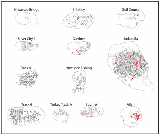
Figure 34.
Petroglyph panels with straight lines shown in red; gray is earlier. Soapstone Quarry scars are outlined (scale bar = 10 cm).
4.15. Composite Motif
An anomalous combination of straight lines and circles around central cupules occurs at Shoal Creek Rock, at a crossing of a prominent northern tributary of the Etowah River in the upper Piedmont of Georgia. Straight lines are conjoined to form three juxtaposed box shapes at Shoal Creek Rock (Figure 35). Within the left-hand box are nine circles, each surrounding a central cupule. In the center of the middle box is another circle surrounding a central cupule. On the right side is a box within a box, with a circle and central cupule in the center and a cupule in each of the outer box’s four corners. Although the cupule within circle motif is found on nearby Reinhardt Rock, the placement of cupules within circles within squares is unique to the Track Rock Tradition. Together with the vertically aligned human footprints to the left and the U-shaped vulvas above the main Shoal Creek panel, the site is considered an outlier, both stylistically and geographically, of the Track Rock Tradition petroglyph sites. Falling within an area formerly occupied by Muskogean Creek communities, the panel is interpreted in terms of Muskogee ethnography in the Section 9.8 discussion of concentric circles below.
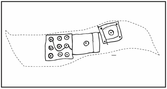
Figure 35.
Anomalous combination of categories at Shoal Creek Rock (scale bar = 10 cm).
4.16. Fine Line Incisions
Fine line incisions, most likely performed with a sharp metal implement, were recorded at the following five sites: Turkey Track Rock A; Turkey Track Rock B; Hickorynut Rock 2; Judaculla Rock; and Hiwassee Rock 5. As most fine lines are shallow and, hence, more prone to weathering, more panels could have had them at one time. A faint, fine-lined, incised, tiny head with two rounded eyes can be seen near the bottom of Judaculla Rock. Both Turkey Rocks A and B contain fine-lined turkey tracks and a multitude of scattered short, straight-lined incisions (Figure 36). Turkey Track A additionally includes two arrows pointing northwards. A medium-length vertical, thinly incised line covers one arm of a winged-looking man on Hickorynut Rock 2. In contrast, numerous short and shallow scratches cover a variety of petroglyphs at Judaculla Rock and Hiwassee Rock 5. The latter scratches are always the latest in the sequence of overlaps.
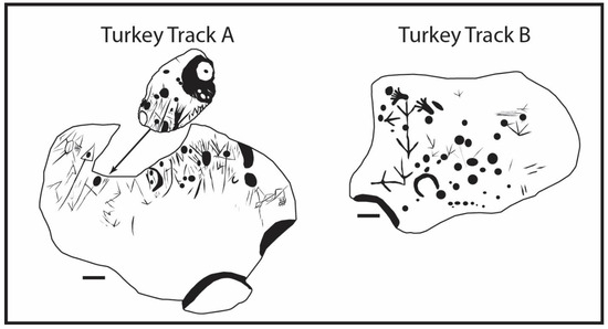
Figure 36.
Fine line incisions on Turkey Track Rocks A and B (scale bar = 10 cm).
4.17. Smooth Hollows and Grooves
Round to oval-shaped hollows with smooth interiors occur at the following four sites: Boling Park Rock, Hiwassee Rock 5, Hiwassee Bridge Rock, and Gardner Rock. Whereas Boling Park Rock is partly submerged in a small creek near its confluence with the Etowah River, both the Hiwassee Rocks are in the middle of the Hiwassee River (Figure 37). Only Gardner Rock is not within water, although a creek runs nearby. The hollows were most likely used for grinding materials into a powder form. Elongated oval grooves on Hiwassee Rock 5 conceivably resulted from grinding and shaping stone tools, such as celts. Since most of these markings do not overlap any motifs, their placement within the relative overlap sequence is uncertain. However, on Hiwassee Rock 5, a few grooves cut into hollows, suggesting that these grooves were created after the hollows were formed.
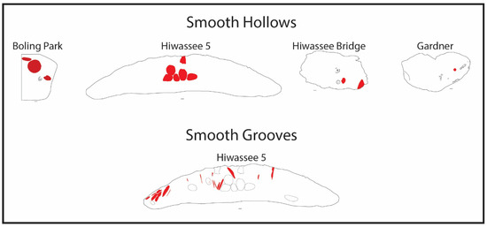
Figure 37.
Smooth hollows and grooves shown in red (scale bar = 10 cm).
4.18. Summary of Motif Categories and Sequence
The above sequence of motif categories is based on an admittedly limited number of direct overlaps, with some motifs “bleeding” into later categories, such as a proposed Woodland period curvilinear figure associated with a Mississippian concentric circle at River Hill Rock 1. At the same time, Woodland pecked turkey tracks re-appear as post-contact incised tracks with metal tools at the two Turkey Track rocks. Also, short sections of older meanders were re-engraved over portions of later footprints, while later cross-in-circles followed the outlines of fainter and earlier meanders. What cannot be denied, however, is the fact that at the earliest known end, a few cupules and meanders predate soapstone scars that are not younger than 3000 years, while at the latest known end, fine-lined incisions done with metal tools cannot be older than 200 years. Based on these two bookends, the Track Rock Tradition petroglyphs lasted at least 3800 years.
Viewed in the light of a few exceptions to the overlap sequence and Native American emphasis on cyclical time, which are considered next, chronological differences become less important. It is proposed that the traditional Native American emphasis on cyclical time and their view of petroglyphs as ancient, sentient entities overrides a concern with linear time, even though Native Americans recognize the latter. Moreover, Native Americans’ practical knowledge of materials and their physical properties is not negated by the fact that they link this knowledge to spiritual matters. The following two sections, which deal with the physical and spiritual qualities of water, illustrate this contention and mark a shift in emphasis in this paper.
5. Formal Thesis: Water as a Medium to Penetrate Rock
Having been awarded federal contracts and with the approval of relevant Native American Tribal Historical Offices to remove deeply carved graffiti from rocks with petroglyphs, it became clear to me that water is an essential ingredient to increase the abrasive effectiveness of my graffiti removal tools. The addition of water as a vehicle for abrasive particles enables the removal of deeply incised graffiti from soapstone. This rock type features surfaces much harder than commonly assumed (i.e., hard soapstone measures up to 4.5 on the Mohs scale, equivalent to that of marble) (Garden State Soapstone 2016). To have been able to peck, engrave, and incise motifs into soapstone and other rock types with petroglyphs in the southeastern woodlands of the United States, Native Americans almost certainly added water during the production process. When mixed with rock particles generated during pecking, engraving, and incising, highly polar water acts as a carrier, with the suspended particles adding to the overall cutting surface area and the pressure exerted. As described above, most petroglyphs in the mountains and foothills of northern Georgia and the mountains of western North Carolina occur near water, albeit in different shapes, sizes, and quantities, ranging from swampy “soaks” through springheads, to creeks and rivers.
6. Informed Antithesis: Water as a Medium to Breach the Divide Between Physical and Spiritual Realms
In addition to using water as a physical means to breach rock surfaces during petroglyph production, Native Americans living in the southeastern United States also interact with water as a medium to bridge the material and spiritual divide between the physical and spiritual realms (Lewis-Williams and Loubser 2014). As will be shown in this paper, multiple Iroquoian-speaking Cherokee and Muskogee-speaking Creek accounts refer to a range of physical (literal), emotional (metaphorical), and existential (esoteric) transformations associated with various occurrences of water and damp surfaces. Physical and metaphorical contact with and immersion in various manifestations of water can be seen as giving “materiality” to a variety of transformational experiences (Lewis-Williams 1997, p. 328). Moreover, viewed together, the material properties of water and the range of contexts in which it occurs makes it an apt “natural model” to describe and guide different emotional and physiological shifts experienced during various life crisis rituals (Whitley 1994, p. 1). A virtually universal concept among Native Americans regarding water is aptly expressed by a Paiute saying the following: “anytime water flows; you have spirits flowing through there” (Stoffle et al. 2011, p. 31).
7. Informed Antithesis: Cherokee and Creek Beliefs and Practices
7.1. Animistic Beliefs as Informed by Altered State Experiences
Considering that the petroglyphs discussed in this paper occur in territory known to have been occupied by various Cherokee and Creek towns, the beliefs and lifeways of these people should inform any interpretive undertaking. In this regard, it is critical to recognize that these southeastern Native Americans do not view and treat physical and spiritual realms as rigidly separate entities, with no reciprocal interaction between the two. Native Americans believe that, like human beings, physical landscape features, rocks, plants, animals, tools made from rocks, plants, and animals, weather phenomena, and the heavenly bodies are conscious beings with spiritual potency and agency. Human interaction with these other-than-human persons accordingly involves verbal and gestural communication, as well as exchanges of goods and services, known in short as “restoring the balance.”
The broad outline of Native Americans’ beliefs above conforms to Tylor’s (1871, p. 387) concept of animism. While denying Tylor’s supremacist associations regarding animistic beliefs as being “primitive,” comparative ethnographic examples support his hypothesis that such beliefs can be traced to the high value particular socio-cultural groups ascribe to altered state experiences, particularly dreams, visions, and near-death experiences. Importantly, it is during these altered state experiences that people, rocks, plants, animals, and other “natural” features take on independent agency, which is mainly counterintuitive when viewed and judged in terms of daily activities and experiences in the physical world of awake consciousness. Essentially, people believe that rocks, plants, animals, landscape features, weather phenomena, and heavenly bodies share an internal energy and possess agency, as they perceive what they see and experience in dreams, visions, and near-death situations to be just as real as during waking consciousness. Many Cherokee accounts, for example, treat dream experiences as real as those being awake (e.g., Champagne 1990, p. 8; Fogelson 1980, p. 77; Mooney 1900, p. 323; 1982a, pp. 27–28). Creeks likewise ascribed great significance to dream experiences (e.g., Adair 1930, p. 334; Bartram 1955, p. 314; Swanton 1987, p. 775). The interaction between physical beings and spirit beings via altered states is succinctly stated by Mooney (1900, p. 492) as follows: “Every sacred dance and religious rite, as well as almost every important detail of Indian ceremonial, is supposed to be in accordance with direct instruction from the spirit world as communicated in a vision” [my italics].
An agreement, understanding, or shared belief among virtually all members of a society, also known as a consciousness contract (Lewis-Williams and Pearce 2005, p. 40), that the counter-intuitive world of altered states is one inhabited by potent spirit beings and seemingly boundless spirit powers is evident in accounts of early Europeans travelling through southeastern Native American territory. According to Bartram (1955, p. 391), who traveled through the southeastern woodlands in the mid-1770s, the Native Americans inhabiting the region “have many accounts of trances and visions of their people, who have been supposed to be dead, but afterwards reviving, have related their visions, which tend to enforce the practice of virtue and moral duties.” Individuals who possessed special access to spirit beings sometimes rose to prominent positions of power and political influence, such as chiefs and priests. For example, Long Warrior, the great chief of the Seminoles in northern Florida during the 1770s, “was acknowledged by the Indians to have communion with powerful invisible beings or spirits, and on that account esteemed worthy of homage and great respect” (Bartram 1955, p. 215). Bartram (1955, p. 390) added that Southeastern Native Americans generally believe that high priests have “communion with powerful invisible spirits, who they suppose have a share in the rule and government of human affairs, as well as the elements; that they can predict the result of an expedition…and indeed their predictions have surprised many people. They foretell rain and drought, and pretend to bring rain at pleasure, cure diseases, and exercise witchcraft, invoke or expel evil spirits, and even assume the power of directing thunder and lightning”.
Adair (1930, p. xxxv), who traded with various Native American groups throughout the southeastern woodlands between the mid-1730s and the mid-1760s, mentions “the secrecy and closeness of the Indians as to their own affairs”. Nonetheless, Muskogee Creek warriors told Adair of spirit beings from the abandoned Ocmulgee Mound descending to the waters of the nearby Ocmulgee River to purify, as well as of spirit “apparitions” warning warriors of impending dangers (ibid., pp. 39–40). In 1765, an old Chickasaw medicine man told Adair (1930, p. 185) that through dancing, he secured Adair’s house from “the power of the evil spirit of the north, south, and west, and, from witches, and wizards, who go about in dark nights, in the shape of bears, hogs, and wolves, to spoil people.” In this account, note how the sorcerers change into animals. Another account mentions an old medicine man who visited spirit beings within a cave in the interior mountains, many miles west of Charleston, South Carolina, to help warriors with their livelihood (ibid., p. 204). Although skeptical of dreams’ efficacy among Native Americans (ibid., p. 26), Adair (1930, p. 334) mentions that the southeastern “Indians in general, are guided by their dreams when they attend…to war” and that “they acted in obedience to their Nana Ishtohoollo, “or guardian angels”, who impressed them in the visions of night” (ibid., p. 409).
7.2. Hierarchy of Ritual Practitioners Among Southeastern Native Americans
Although knowledge of and interaction with spirit beings were and continue to be widespread among southeastern Native American communities, the knowledge is not shared equally or practiced with equal intensity. In the past, ritual practitioners included at least the following three grades of people: priests, shamans, and part-time individuals. Priests, also referred to as Conjurers, Beloved Men, or Knowers, were particularly respected among the Native Americans of the southeastern woodlands. A few Cherokee women, known as Beloved or Pretty Women, played a significant role in making decisions regarding war and peace (Mooney 1900, pp. 489–90). The Ani’-Kwăta’nĭ, an ancient hereditary group of priests among the Cherokee associated with mounds, was overthrown by popular uprising around 1780, if not earlier. Following the demise of the Ani’-Kwăta’nĭ, the priests’ religious tasks were assumed by village-level shamans (Haywood 1823, p. 266; Mooney 1900, p. 392). One of the last of such priest leaders was an elderly Indian known as Connocotte, or Old Hop, who lived at the Cherokee capitol town of Chota in Tennessee during the early 18th century (Adair 1930, p. 85). With the collapse and scattering of most traditional Indian polities by the end of the 18th century, prominent warriors or individuals with European connections replaced the priests as political rulers, while shamans retained their advisory position in social, economic, and religious affairs. A category of feared individuals that cut across all of these was known as sorcerers. Priests exerted influence at an intra-polity and inter-village level, shamans exerted influence at an intra-village and inter-household level, and everyday people exerted influence at an intra-household level. With the disintegration of Cherokee and Creek polities by the mid-1780s, shamans replaced priests to officiate during the annual first-fruit ritual, known as the Green Corn Dance among the Cherokees and the Busk among the Creeks.
7.3. Townhouses and Rivers as Central Ritual Locales
The rite of the first fruits typically began in early fall, when corn became full-eared. When priests still had widespread influence among the Cherokees, the Green Corn Ceremony was held in the capital town of individual townhouse-centered polities. In 1765, for example, Timberlake described a Cherokee Corn Dance performed on a large square in front of the townhouse door of a capitol town (Wetmore 1983, p. 46). Among the 18th-century Creeks, Adair (1930, p. 117) witnessed communal processions going for purification in a river adjacent to the capitol town in which the priest leads the way from the townhouse, followed in order of diminishing rank by his attendants, shamans, warriors, women, children, and transgressors of sacred laws. During these annual Busk and Green Corn renewal rituals, all the participants took medicines, fasted, extinguished old fires, scratched themselves, immersed in the closest running water, and waited for the priest from the main town to ignite a new fire.
With the collapse of centralized polities, purification in rivers and creeks continued, with townhouses, winter houses, and individual sweat lodges taking over the function of “temples” on mound tops. According to Mooney (1900, p. 230) the proper place for story-keepers and shamans to meet was in a townhouse, the proper time was at night, and the proper rituals that followed at daybreak for all participants were to be scratched with a bone-tooth comb and dipping seven times in a river or creek during the Going to Water rite while facing the rising sun.
All-night vigil and fasting, be it in the winter house or sweat lodge, is expected to induce visions and dreams among Native Americans (e.g., Swanton 2000, p. 610). Generally associated with the Going to Water ceremony, fasting precedes attempts to beat rival villages during inter-village ball games, success during raiding, recovering from illness, winning the affection of a person, or success at hunting (Mooney 1982b, p. 20). Considering that older people have fasted and dreamt so many times, the Cherokees tend to regard them as on equal footing with shamans, the latter being known for their rigorous regimen of fasting. Cherokees believe that spirit beings, such as the Immortals, can see the Cherokees wherever they go and whatever they do, but to see the spirit beings, individual Cherokees must fast, dance, and go to water (e.g., Mooney 1900, p. 342), especially during certain liminal times of the day, month, and year or during life crises events. Spirit people can also appear and disappear unannounced during daily activities, such as when a boy constructs a stone fish weir across a river or when a group of women crosses a river shoal following a townhouse dance (Mooney 1900, p. 332).
7.4. Rituals as Re-Enactments of “Mythical” Events
While it is true that individuals can see and visit spirit beings by following proper rituals or simply working in or wading through a river, it is also true that, in some instances, individuals transform into spirit beings when associated with water or moist surfaces. Many Cherokee and Creek accounts mention bodily transformations that occur at rivers, streams, and other watery features. In this regard, it is worth mentioning that instead of being “just so” stories, the accounts were traditionally shared by ritual practitioners with listeners “who observed the proper form and ceremony” (Mooney 1900, pp. 229, 431). Moreover, what are commonly referred to as Cherokee and Creek “myths” are more correctly oral traditions to invigorate and guide correct ritualized conduct. Ongoing ritualized re-enactments of oral traditions, including those dealing with creation, demonstrate that these oral traditions serve as mnemonic devices to help create an ongoing present, rather than being relegated to a distant past.
Among the Cherokees and Creeks, oral traditions and ritualized activities are best viewed as self-similar events, one conducted orally and the other through action. For example, a Creek creation account of a man transforming into a Horned Serpent (Grantham 2002, p. 25) is reflected in a Cherokee account, where a boy transforms into a Uktena, a horned serpent, as it slithers from a hothouse into a deep pool at the bend of a nearby river (Mooney 1900, p. 304). According to the accounts of different Creek groups, individuals transform into a snake, at times with horns, as they move between a special house and a watery body (Grantham 2002, pp. 199–227). Normally, these transformed individuals either disappear from everyday view or become shamanic teachers of medicine songs. Cherokees view bears as transformed people, too, some of whom live within a mountain townhouse behind an “enchanted” lake (Mooney 1900, pp. 264, 328). Cherokees believe that spirit beings, such as bears, can move from one underground townhouse to another through subterranean caves, while leeches and snakes can travel from one river to the next along watery fault lines (ibid., p. 475).
According to Watts (2013), Native American stories are not “myths” but expressions of “Place-Thought,” implying that the landscape and its features are sentient and predominantly feminine in nature. The same stories and rituals, which are sometimes tied to widely separate locales, share specific physical characteristics. These spatially separate places, accordingly, serve as the same natural model (i.e., they are multivalent). Widely separate rivers, towns, and mountains with the same name are examples. However, places with different names can share significant characteristics, too, or a single place can have multiple associations (i.e., it is polysemic).
7.5. Rivers as Sentient Beings
Cherokees view and interact with rivers as “Long Man,” or Yûwï Gûnahi’ta, a sentient giant with his head up in the mountains and his foot down in the floodplains, speaking in murmurs that a shaman should understand (Mooney 1982c, p. 30) but also that some gifted children may grasp (Mooney 1900, p. 426). Cherokees invoke Long Man’s aid by fasting and prayer before transitional and uncertain phases in life, notably birth, curing, raiding, courting, hunting, combating sorcery, and ball games. Since going to and purifying in Long Man is so essential, townhouses that serve as preparatory places for Going to Water rituals tend to be located close to riverbanks. During Going to Water rituals, a shaman proclaims that “I originated near the cataract, and from there I stretch out my hand towards this place…Now my soul stands erect in the seventh heaven” (ibid., p. 31). Long Man is a sentient being who shamans and other supplicants can follow from its foot near a valley townhouse of physical beings to its head that contains a townhouse of spirit beings (Mooney 1900, p. 240). Early mornings and transitions between seasons are good times to enter Long Man, because it is during these times that the diluted power of the sun, falling leaves (Mooney 1891, p. 336), and new plant saps add the right amount of medicine to the flowing water (Witthoft 1983, p. 69). As a living being, Long Man is respected for its power to ingest, hold, transport, and dispose of any substance cast into it, such as stones, sticks, fish, and beavers (Mooney 1900, pp. 31, 32). Long Man has the ability to share potent lessons with those who can understand what he says and the ability to carry medicines. Still, these are two of many reasons why almost every rock or bend along his body is accompanied by a story (Mooney 1900, p. 230). On a broader landscape level, the spirits of dead people travel west and downstream along rivers to the land of the dead, while living shamans and other supplicants travel east and upstream to enter the land of spirit beings (e.g., Witthoft 1983, p. 68). In many ways, Long Man is a larger-than-life human being; the spiritual energy, or soul, of both resides in their heads (Witthoft 1983, p. 68) while their bodies can host other beings, such as the Uktena horned serpent (Kilpatrick and Kilpatrick 1967, p. 44). This creative spiritual force, known as the first soul, is conscious and has continuity after physical death. Significantly, the first soul that resides in the head creates and supplies life-giving watery fluids to both rivers and human bodies (Witthoft 1983, p. 68). To gain access to this life-giving source located in the head, in times of scarcity, change, and need, it becomes necessary for human beings to travel upstream.
In the past, shamans, supplicants, and, at times, entire towns (Mooney 1900, pp. 336, 341) traveled upstream to visit potentially helpful spirit beings residing in their mountain-top townhouses. The townhouses of spirit beings are most frequently located within prominent mountains or hills. Still, they can also be found behind waterfalls (Mooney 1900, p. 418), within caves (ibid., pp. 242, 372), or at the bottom of river pools (ibid., pp. 347, 349). As mentioned above, watery trails usually lead to these townhouses, such as when two female spirit beings inform a lone suitor who is reluctant to enter a creek that “this is not water, this is the road to our house” (Mooney 1900, p. 345).
7.6. A Hierarchical Universe of Self-Similar Beings
The universe of Cherokees and Creeks is a nested one of self-similarity at different scales; what exists in the world of spirit beings is mirrored in the world of physical beings and vice versa. Notably, the Creek square ground is a microcosm of one in Sky World (Grantham 2002, p. 67), and the Cherokee townhouse is a microcosm of Sky Vault (Mooney 1900, p. 240).
Mirroring the hierarchy of ritual practitioners, Cherokees believe in a hierarchy of spirit beings; those at the highest level are inaccessible to most human beings. Mirroring the matrilineal arrangement of Cherokee society, spirit beings are viewed and interacted with as members of an extended matrilocal family. Near the top of the hierarchy, the female Sun and male Moon reside on opposite ends of a massive, dome-shaped townhouse with solid rock ceilings and walls, its door opening alternately to the east and the west. This door serves as a portal that allows the Sun to enter from the east (the land of life-giving powers), travel along the ceiling of the rock-lined dome, and exit to the west (the darkening land of the physically departed). Unsuccessful Cherokee and Creek shamans who want to follow the route of the Sun through the townhouse in the sky are crushed by the closing door (Mooney 1900, p. 256; Grantham 2002, pp. 173, 184).
A lower equivalent of Moon is the “Great Thunderer,” known as Kanati, who lives in a townhouse with the Thunderer family of spirit beings, immediately outside the western door of the sky vault townhouse. It appears that Kanati at first inhabited a cave in the north face of Black Mountain in northeastern portion of west North Carolina (Mooney 1900, p. 432) but later re-located to Pilot Knob in central western North Carolina (ibid., pp. 242, 342). Ever since, supplicants approached Kanati and his Thunderer family’s townhouse within Pilot Knob. At times referred to as the “Lucky Hunter,” Kanati lives with his wife, Selu, who has various other names, such as “Great Female,” “Old Mother, or “Corn,” and their two sons, known collectively as the “Thunder Boys” and individually as “Young Boy” and “Wild Boy.” When Selu washes the butchered deer and turkey that Kanati brought home, blood drops falling in a nearby river give rise to Wild Boy, also known as “Lightning.” While on a journey to the darkening land of the west, Wild Boy creates grooves in the rock where he rolled a roaring chunky stone across the Tennessee River (Mooney 1900, p. 311).
Like their father, the “Thunder Boys” are not only great hunters but also gain access to hordes of game animals hidden behind a boulder in Kanati’s Black Mountain cave (Mooney 1900, pp. 243, 249). When the boys remove the stone barrier, the escaping animals and birds create a thundering sound. In the ensuing scramble, the animals also left their tracks in the soft rock. The cave is in the vicinity of Gardner Rock on the northwestern approach to Black Mountain. A related account mentions animals and birds escaping from the western land of spirit beings, which created the tracks at the Track Rock site in northern Georgia (ibid., p. 419).
Earth-bound spirit equivalents of Kanati and Selu are the red giant Judaculla and his human wife. Like Kanati, Judaculla is a hunter. Best known as “Master of the Game,” Judaculla’s Europeanized name derives from the Cherokee tsulʽkălû’, which means slanted (Mooney 1900, p. 338). The slanting refers to his pupils having the lenticular shape of certain snakes and cats (Tom Belt to Scott Ashcraft 2014, personal communication). The Creeks in Oklahoma speak of the Tall Man, a giant with vertical eyes (Grantham 2002, p. 35). Vertical pupils are associated with good night vision and also serve as a metaphorical reference to the ability to see through barriers, including rock surfaces or the thoughts of others within their minds. Like spirit beings in general and accomplished shamans, Judaculla can see the thoughts of people and visit shamans in their dreams (Zeigler and Grosscup 1883, p. 23; Mooney 1900, pp. 327, 338).
Judaculla first lived with his wife in her tiny hothouse within Kanuga Town on the Pigeon River before departing westwards to his big townhouse within Tsunegûñyĭ Mountain, currently known as Richland Bald, at the source of the Pigeon. Their first child is born when his mother-in-law tosses his wife’s menstrual blood into the river, while the second is born along the damp riparian trail leading up to his townhouse. Imprints of his wife giving birth to the second child and the footprints of the two rapidly growing children can still be seen on the rocks along the way (Mooney 1900, p. 339). Before its destruction, a petroglyph rock bearing these footprints could be visited between the forks of the Pigeon River (ibid., p. 480). Unlike Judaculla’s wife with her shamanic attributes, such as walking up and down vertical cliffs and not being afraid of Judaculla’s countenance, Judaculla’s wife’s brother is at first unable to enter Judaculla’s mountain top townhouse where Judaculla’s game is kept (ibid., p. 341) and later fails to see Judaculla face-to-face. Yuchis have accounts that echo those of Kanati and Judaculla of a keeper, or Master of the Game, watching over deer kept in a cave (Grantham 2002, p. 91). Like the other members of the extended Thunderer family, Kanati and Judaculla’s actions are often associated with a thundering sound (Mooney 1900, pp. 340, 435).
Based on Cherokee accounts, Judaculla offered special spiritual dresses to his followers who wished to join him in his townhouse, provided that they followed a demanding ritual protocol of fasting and bathing in water (Mooney 1900, pp. 340–41). Successful adherence to the ritual’s demands meant that the acolytes could become members of Judaculla’s extended family, who controlled the release of game (Haywood 1823, p. 280). Approaching Judaculla’s mountain top townhouse from the opposite direction, along the Caney Creek trail from the west, Cherokee hunters had to first stop at Judaculla Rock along the way. Failure to do so enraged Judaculla, who, with a thundering sound, leaped from his mountain top abode down onto the rock in the valley below, where he incised a straight line into the rock with his fingernail, designating it as a boundary to his terrain that needs to be respected (Parris 1950b, pp. 36–37). This line and his seven-fingered handprint can still be seen on the rock. A now destroyed petroglyph boulder on the Tuckasegee River, near the Mother Town mounds site known as Kadua, had impressions of Judaculla’s big footprints and deer tracks. The destroyed petroglyph boulder was a place where the Great Female’s family appeared to Cherokees (Mooney 1900, pp. 409–10). The Great Female is most probably Judaculla’s wife and mother of his extended family.
Oral traditions suggest that Judaculla used to have a wide sphere of influence that roughly coincides with the distribution of Track Rock Tradition petroglyph sites in the region, extending from at least Kanuga Town on the Pigeon River in the north to Blood and Yonah Mountains on the southern edge of the Blue Ridge Mountains (Kirk 2013, p. 80). This distribution excludes Gardner Rock in the extreme north and the petroglyph sites in the Etowah River headwaters of the Georgia foothills. Whereas Gardner Rock falls in the area that features accounts of Kanati’s cave with game, the Georgia foothills is an area more closely, but not exclusively, associated with Creeks. Yet, the 19th century antiquarian Charles Jones (1873, p. 337) suggests that Silver City Rock in the Georgia foothills is the work of Cherokees, bearing in mind that before their removal west of the Mississippi River around 1838, Cherokee settlements extended to the Chattahoochee River, immediately south of the southernmost Track Rock Tradition petroglyph site.
Like Kanati, the Thunder Boys, and Judaculla, the Uktena, a horned serpent, is closely associated with thunder. Serpents, including the Uktena and rattlesnakes, are described as possessing human attributes and are depicted as actual people in certain accounts (Mooney 1900, pp. 253, 346). For example, before embarking on journeys or conducting raids, Cherokees recite sacred formulas that mention Uktena has feet (Kilpatrick and Kilpatrick 1967, pp. 134–35). While a large Uktena resides beyond the sky vault, multiple smaller ones inhabit mountain passes, caves, and river pools (Mooney 1900, pp. 297, 346). The upper Uktena, also known as “Keen Eyed,” tends to respond kindly to Cherokee sacred formulas, while the lower ones are tricksters that have been banned from the sky vault. Uktenas usually have horns on their heads, blazing crystals on their foreheads, and luminous scales (Mooney 1900, p. 297). Shamans in possession of Uktena crystal or scales are considered powerful and, at times, can transform into an Uktena (ibid., pp. 304, 460). Some priests and chiefs are buried with the remains of an Uktena and his crystal (ibid., p. 396). Those that possess a crystal from the forehead of an Uktena can read the minds of other people (ibid., pp. 458–59), very much like Judaculla and other powerful spirit beings. Spirit beings and shamans who can read the minds of others can make impressions into the rock surface, such as a dying Uktena creating holes in the rock where Citico Creek joins the Tennessee River (Mooney 1900, p. 315) or a captured Uktena creating deep scratches on rocks along the Tuckasegee River (ibid., p. 410). Because some shamans transform into Uktena, it can be argued that they were responsible for the scratching. Also, like almost all other spirit beings, Uktena is associated with thunder (Mooney 1900, p. 346; Kilpatrick and Kilpatrick 1967, pp. 51–56). A Cherokee told Mooney (1900, p. 481) that “Thunder is a horned snake, and lightning its tongue, and it lives with water and rains.”
Rattlesnakes, too, are associated with lightning and thunder among Cherokees (Fogelson 1982, p. 96), while tie-snakes among the Creeks are closely associated with lightning. A Creek shaman who transformed into a sharp-breasted snake cut grooves into rocks that divided one river pool from another (Swanton 2000, p. 493). In doing so, the snake resembled lightning. Shamans use the horns of lightning snakes as powerful medicines for hunting and war (Swanton 1987, p. 773; Swanton 2000, p. 494). According to Grantham (2002, p. 65), southeastern Native Americans considered hunting and warfare to be sacred undertakings, accompanied by elaborate rituals. Snakes are associated with lightning and war, especially among different Creek groups (Grantham 2002, pp. 26–28, 220–28).
Belief in a variety of lightning and thunder beings is widespread among southeastern Native Americans, including ascribing thunderstorms to a host of spirit beings fighting in the sky (Adair 1930, p. 68). Certain Creeks go further by implying that lightning and thunder are independent other-than-human persons (Adair 1930, p. 773), who can either assist or hinder humans. Helpful thunder on the day of planting tobacco is considered suitable for the plants (Kilpatrick and Kilpatrick 1967, p. 9) and Cherokees who view thunder as a benevolent being are seldom struck by lightning (Fogelson 1982, p. 94). Creeks believe that a long snake that rises out of water or from beneath a rock can throw a blue lightning bolt back up to the sky and so gain the attention of powerful spirit beings above (Swanton 2000, p. 486). In return, lightning is one way that the Sky beings communicate with spirit beings and shamans below the ground or within water, considering that the Thunderers above the sky vault send bolts down to the earth as a creative force (Mooney 1900, p. 240).
Little People are, for the most part, earthbound Thunderers. Little People tend to live in caves, behind waterfalls, and under fallen trees, from where they can announce their presence with short claps of thunder (Mooney 1900, p. 435). Unlike most other spirit beings, however, Little People tend to be smaller and more mischievous. Little People can be kind, such as helping with chores or returning lost children to their homes, but can also be mean, such as bewildering people or causing harm to them or their possessions from a distance (Swanton 2000, p. 497). Hunters tend to find evidence of Little People in the form of footprints that they leave after crossing a river or disappearing behind a waterfall (Mooney 1900, pp. 333–34). To a lesser extent than Kanati and Judaculla, Little People have power over game animals, and for this reason, hunters tend to pray for their assistance. As earthbound manifestations of Wild Boy in the sky vault, Little People can trick hunters who are not following proper ritual protocol. Little Peoples’ association with life-giving powers is also evident in their ability to impregnate women (ibid., p. 430).
There is a clear and intimate connection between Thunderers and both the life-giving and destructive powers of lightning, water, and rain. Many Creek stories claim that in the beginning, there was only the Sun, water, and a few animals (Grantham 2002, pp. 90–93, 107). The animals could think, speak, and act like human beings, but the problem was to make the earth livable for people. Cherokee accounts claim that the first fire was created when the Thunderers sent lightning into the center of a hollow sycamore tree (Mooney 1900, p. 240). This tree, which can be viewed as a primal townhouse, was surrounded by a body of water, which could be an allusion to a flooded square ground, as seen in accounts among the Creeks (Grantham 2002, p. 206) and Cherokees (Swanton 1987, p. 769). In one account, it was a water spider that brought the fire across the water for everybody to share, including humans. Other accounts suggest that the sunlight was too bright for people on Earth, and it was a human-like rattlesnake that bit the Sun, causing her to diminish the intensity of the light so that humans could share it in the form of earthly fire. Cherokees believe that Fire is a sentient other-than-human person that plays an intermediary role between humans and Sun (Wetmore 1983, p. 52). Traditionalist Keetoowah Cherokees, conservative Creeks, and few Natchez consider the fire in the center of their townhouses and square grounds as a connection to their deep past (Hendrix 1983, p. 73). This fire, addressed as “Ancient and Honorable Red Person,” is usually built with four logs radiating out from the center in the four cardinal directions (ibid., p. 77). However, Bartram (1955, p. 358) reports a split cane fire that resembles a spiral in the center of a Creek townhouse. The central fires of important townhouses can become permanently imprinted on the landscape, such as the fire that still burns below Kadua Mound (Mooney 1900, p. 396). In contrast, the smoke holes directly above central fires continue to re-appear in the center of whirlpools (Grantham 2002, p. 209; Mooney 1900, p. 347).
Once a year, fires within the townhouses of prominent mother towns are extinguished before Cherokee Green Corn Dances and Creek Busk rituals. New fires are lit within the central townhouse, and the burning logs are then distributed to re-light the fires of subsidiary townhouses in the same river valley. During Busks, participants spend time around the fire before going to the nearby river for purification (Adair 1930, pp. 106–17). During certain Green Corn Dances, Lanham (1849, p. 424) reported that Cherokees diverted water from nearby rivers to partially flood the square ground in front of the townhouse door. To enter the pool, participants must pass through a fire that is lit between the dry and wet portions. During various other rites of passage, Cherokee shamans pray to the Sun, Ancient White Fire, and the Long Man River before immersing themselves in rivers (Mooney 1982c, p. 31). Like rivers, fire hearths are portals to the world of spirit beings, both in the sky and underground. For example, to help the spirit of a deceased person travel to the land of departed spirits in the west, a shaman addresses Sun by staring down into the fire of a domestic hearth (ibid., p. 32). As a gatekeeper to the world of spirit beings, Fire is a sentient being who can see and hear human beings and judge their conduct (Adair 1930, p. 106).
Those individuals who can master the requirements of Fire and travel successfully through watery mediums and the sky are mostly priests and shamans adhering to traditions of proper conduct. Shamans give certain “chosen” newborn Cherokee babies medicines that bestow them potential powers to see invisible things or things behind barriers, to shift forms, and even to fly out of their bodies, visit distant places, and observe things from above (Fogelson 1980, p. 67; Witthoft 1983, p. 71). Algae and lichens collected from moist rocks, that symbolize the dark underworld, are essential ingredients in these medicines. Not all individuals aspiring to become shamans experience the spirit world in the same way; some enter and exit successfully, while others leave the profession, some go insane or permanently transform into an animal, and others “die” as they disappear and never return in physical form (Mooney 1900, pp. 324–33). Shamans who successfully enter, travel through, and exit the parallel world of spirit beings tell stories of personal encounters that defy everyday logic, particularly the abundance of things and things that are the reverse of those in the physical world. It is the reverse nature of the spirit world that serves as an inspiration to those who dare to enter it, bearing in mind that scarcity and struggles in the physical world imply abundance and peace in the spiritual world. Those who survive the ordeals of extra-corporeal travels during dreams, visions, and near-death experiences tend to end up where they started, such as outside a cliff face or within a hothouse, and are, accordingly, able to share their experiences with others (Grantham 2002, pp. 181, 187; Mooney 1900, p. 342). Shamans not only engage with spirit beings or turn into such beings, but they also engage and often fight with competing shamans. This competition tends to occur during dreams and over long distances (Swanton 2000, p. 654).
7.7. Summary of Cherokee and Creek Beliefs and Rituals
The above evidence strongly suggests that altered state encounters with animated beings in the spirit world inform and reinforce the beliefs and practices of associated communities. In turn, the altered states of consciousness are guided by the traditional beliefs and practices of the associated communities.
The above overview of relevant Cherokee and Creek beliefs and rituals highlights commonalities between the two linguistic groups. These commonalities, in turn, highlight recurrent associations between humans and spirit beings as mediated by watery features, rocks, and fire. Common themes include the following:
- Self-similar relationships exist at macro and microcosmic scales, most noticeably, the mirrored behavior of Sun and Moon, Selu and Kanati, Judaculla and his Wife, and Little People and everyday physical people.
- Reciprocal exchange relationships exist between the physical and spiritual realms, expressed as “restoring the balance,” manifest in various ways, such as through Uktena, lightning, and ritual practitioners traveling back and forth between the physical and spiritual realms, or hunters leaving “offerings” of deer meat to spirit beings.
- Thundering sounds of various kinds and intensities are associated with virtually all spirit beings. They are experienced by both ritual practitioners and ordinary people who are stressed or in contact with these entities.
- Spirit beings, or ritual specialist representatives, create impressions on rocks, including lines created by Wild Boy playing chunky, tracks left by animals and birds escaping from the Kanati’s townhouse, dueling Uktenas and lightning bolt snakes carving rocks, menstrual blood impressions left by Judaculla’s wife, Judaculla’s finger drawn lines and handprints in Judaculla Rock, and the footprints left by Judaculla’s children.
- Shamans and other ritual practitioners who assumed the identity of spirit beings, such as Uktena, or individuals who became part of Judaculla’s extended family, are the ones who created the petroglyphs.
- By entering water, priests, shamans, and individuals seeking favors from spirit beings can transcend physical and mental barriers between the physical and spiritual realms, such as those represented by rocks.
- Fire, the antithesis of water, is also a gateway that allows for movement between realms.
- Locales that are widely separated from other locales on the ground, in the sky, or below the ground can share physical and metaphorical attributes.
- The movements between vastly separated locales, both horizontally and vertically, are informed by out-of-body sensations experienced by ritual specialists during dreams, visions, and near-death experiences.
- The socio-cultural acceptance of altered states of consciousness as part of reality among southeastern Native Americans nurtures the impression that rocks, plants, animals, and specific artifacts and features are sentient beings.
The self-similar hierarchical structuring of the Cherokee universe is graphically represented in Figure 38.
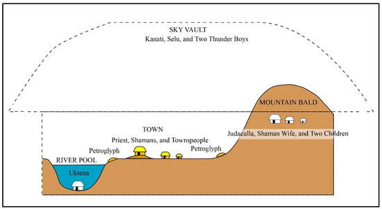
Figure 38.
Idealized side view showing petroglyphs within a nested universe.
The ethnographically informed themes outlined above are now applied to the different petroglyph categories, broadly in the sequence of their observed and recorded overlaps.
8. Informed Antithesis: Significance of the Petroglyphs in Terms of Cherokee and Creek Beliefs and Practices
Tenacious Native American Beliefs as an Information Filter
Reliable traditional information that is handed down orally and via ritual actions tends to be esoteric (not fully understood by all the members of a community) and confidential (not to be shared with unqualified individuals) (Stoffle et al. 2000, p. 40). In addition to not having access to the full range of relevant ethnographic information, the range of physical evidence is incomplete, due to damage and destruction by natural and human agents. Regardless of these limitations, it is assumed that sufficient ethnographic and physical details are available to appraise the traditional significance and ongoing use of petroglyphs in the southeastern mountains and foothills.
The power of the spirit world is traditionally tied to creation and permeates the Native American cosmos “like spider webs in a thin scattering and in definite concentrations with currents, generally where life is also clustered” (Stoffle et al. 2000, p. 43). Priests, shamans, and other ritual practitioners use spirit power to bring creation into the present so that they can act as if being within that powerful time (e.g., Bean 1976, p. 410). But spirit power has diminished since the original creative events in quality, quantity, and availability, especially following the large-scale subjugation, relocation, and domination of Native American communities by European settlers (ibid., p. 411). Surviving traces of spirit power in the physical world are nonetheless kept alive by ongoing interactions between Cherokees and petroglyphs that fall within their recent interaction sphere, particularly Judaculla Rock, Hiwassee Fishing Rock, and Turkey Track Rocks, all three being within short distance from the Qualla Boundary Reservation of the Eastern Band of Cherokee Indians.
9. Informed Antithesis: The Multiple Meanings of and Various Interactions with the Petroglyph Motifs and Rocks
9.1. Introduction
What follows is the sequence of archaeologically derived motif categories interpreted primarily in terms of Native American beliefs and practices. As will be shown, from a Native American perspective, the time differences inferred by archaeologists become mostly inconsequential. It also becomes clear that a single motif category can have multiple meanings (i.e., they are polysemic) and that different motif categories can have the same meaning (i.e., they are multivalent). Accordingly, although presented individually, motif categories only make sense when interpreted with other categories on the same panel, regardless of inferred age differences.
Beau Carroll (2020, personal communication), a Cherokee traditionalist and archaeologist, explained that the motif categories classified by archaeologists are not simply representations of things, but rather living parts of those things and the sentient beings that created them. Accordingly, damage to those things or misrepresenting them harms not only the attached creative entities but also those people who transmit and receive the information. Bearing this caveat in mind, I take a risk sharing the following interpretations, with the heartfelt hope that they help promote positive contemplation, greater appreciation, and better preservation of the petroglyphs.
9.2. Meanders
The oldest markings among the Track Rock Tradition petroglyphs are cupules and meanders. Unlike cupules that continued to be produced throughout the petroglyph sequence, meanders are concentrated at the earlier end of the overlap sequence. Due to the antiquity of meanders, it is perhaps not surprising that Cherokees do not identify meanders with certainty. For example, when shown a tracing of the meanders on Reinhardt Rock, Jeremiah Wolfe (2001, personal communication), a “Beloved Man” among the Eastern Band of Cherokee Indians was unsure but he suggested that they could represent trails. Because he did not elaborate, it remains unclear if he meant physical or metaphorical trails or both.
Zigzag lines on Track Rock 3 and Squirrel Rock resemble lightning bolts, while most of the other meanders are reticulated networks of arcs and bolt-looking forms (see Figure 18 above). It is, accordingly, possible that these multiple seemingly chaotic lines on 24 boulders are metaphorically associated with the lines created by Wild Boy, a member of the primal Thunderer shamanic family, while playing chunky (Mooney 1900, p. 311). Uktena are also known to create deep scratches in rocks, at times in the form of lightning bolts (ibid., p. 410). Because shamans are known to transform into Uktena, it can be argued that they performed the scratching. Thunder and lightning are, after all, audible and visual phenomena experienced by ritual practitioners who have transformative experiences when entering the world of spirit beings. As described above, lightning bolts not only transmit spirit energy from the sky to the ground and back again but also between distant locales on the ground. As shown in the next section, petroglyph boulders are located on riverine trails leading to the abodes of the Thunderers. It is conceivable that spirit beings and their shamanic intermediaries peck and engrave lightning bolts on certain rocks along the trails as visual cues to what overpowering visual and auditory experiences to expect when entering the abodes of powerful spirit beings. Petroglyphs as places where Cherokee hunters and acolytes of Judaculla must stop to “rest” are attested by Cherokee accounts regarding Judaculla Rock (e.g., Parris 1950a, p. 37), a destroyed petroglyph rock within the fork of the Pigeon River (Mooney 1900, p. 339), and at Track Rock (Mooney 1900, p. 419).
Tom Belt, a Cherokee linguist and traditionalist, informed Scott Ashcraft, a Forest Service Archaeologist, about a Cherokee ritual in which water with medicinal properties from the spring below Judaculla Rock is poured over the top ridge of the rock (Scott Ashcraft 2010, personal communication). Water that runs down the vertical meanders and lines is collected in open containers at the bottom of the rock (Figure 39). The collected water has gained additional medicines absorbed from the rock on its way down. The medicinal potency of the rock is enhanced by pouring crushed renamed tobacco and powdered red ocher into a few of the bigger cupules. The largest cupule in the rock’s surface is also used to rest tobacco pipes, the stems of which should come together if set down correctly. Whatever the antiquity of meanders, Cherokees recognize their presence and interact with them as an integral part of the rock.
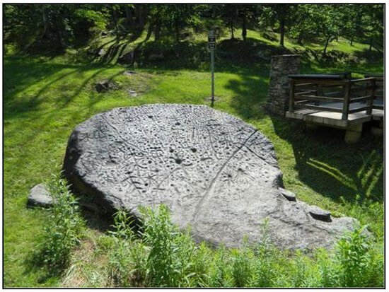
Figure 39.
Photo of Judaculla Rock showing the spring in the center left (Jannie Loubser).
9.3. Cupules
Cupules have a range of meanings and use. Surprisingly, given the close geographical fit between the distribution of cupules and Cherokee towns, hardly any information regarding cupules comes from published Cherokee sources. A Cherokee account of a dying Uktena creating holes in the rock at the confluence of Citico Creek and the Tennessee River (Mooney 1900, p. 315) could refer to cupules, though. The placements of cupules as heads of petroglyph figures, as centers of concentric circles, and within each quadrant of cross-in-circles show that at least some were deliberately integrated into petroglyph motifs. Most cupules, however, occur apart from petroglyph motifs.
The ubiquity of rock surfaces with cupules in an area once inhabited by the Cherokee may have also resulted from their production process, generating a surprising amount of rock dust. As already explained, the addition of water speeds up the process of creating cupules and a substantial pile of wet slurry (see also Loubser 2005, p. 153). The location of most cupule surfaces in northern Georgia and western North Carolina near or within water might be due, at least in part, to this practical reason.
Dust and slurry from cupule production have dietary benefits, including trace elements that support pregnancy, alleviate heartburn, and serve as general dietary supplements (e.g., Callahan 2004). Female Pomo and Shasta Native Americans of northern California, for example, ingest rock dust to become fertile. At the same time, hunters believe that the rock dust released into the sky will bring rain and game animals (e.g., Merriam 1955; Parkman 1995).
Callahan (2004, p. 70) notes that Dakota names for boulders with cupules suggest that they are dwelling places of spirit beings that impart the boulder’s internal energy and the ability to move on its own. Moving boulders are mentioned in Cherokee accounts, such as the lone hunter that sat on a boulder that turned into a slow-moving turtle within the cavernous townhouse of the Thunderers (Mooney 1900, pp. 345–46). The turtle-shaped Allen Rock, with multiple cupules across its surface, also known as Turtle Rock (Figure 40), lies on an old trail that once connected a Cherokee townhouse near modern-day Clarksville with a cave behind Tallulah Falls, where the moving turtle rock resides. Judaculla Rock, with its multiple cupules, is also known as Turtle among the Cherokees (Loubser and Ashcraft 2019, p. 262). Like turtles, these petroglyph boulders, with their multiple cupules, serve as gatekeepers to the abodes of spirit beings (ibid.).
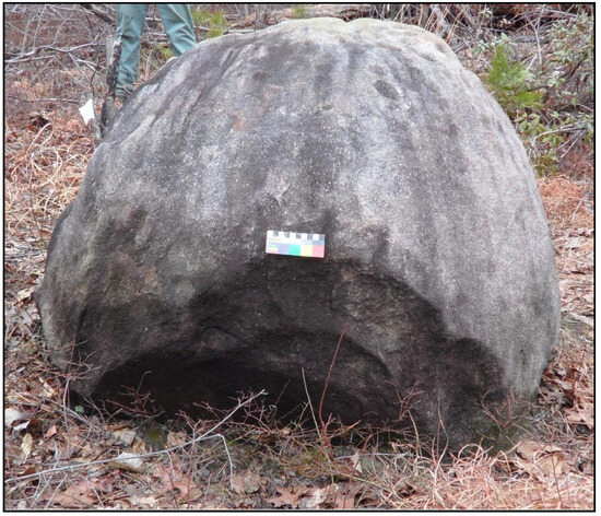
Figure 40.
Photo of Allen Rock, showing its turtle shape (Jannie Loubser).
Once produced, cupules take on additional functions, such as those on Judaculla Rock that serve as receptacles for medicines and ritual paraphernalia. Placing medicines within a cupule is also recorded among the Muskogee Creeks, where a young initiate seeking to become a shaman chews a root placed within a solitary cupule on a riverbank. Guided by an invisible voice to the cupule, the rock within which it is placed cracks with a thunderous sound (Lewis and Jordan 2002, p. 49). In another account, Little People guide an adult Natchez hunter to a cupule filled with medicines. By imbibing the medicinal concoction, the hunter successfully kills a deer (Swanton 2000, p. 497). Of interest in these two accounts are the voices of spirit beings guiding the individuals to the location of rare cupules, that the one acolyte is an apprentice shaman and the other a hunter, the riparian setting of at least one cupule, the medicines placed within, and the ensuing thunderous sound in one instance and success in acquiring deer in the other. Although a few cupules have been recorded west and east of the region covered by the Track Rock Tradition petroglyphs (see Figure 15 above, Alan Cressler 2023, personal communication), the interaction of the two Creek individuals with cupules resonates with Cherokee beliefs and practices, particularly the relationship between petroglyphs and hunting but also likely procreation.
9.4. Soapstone Bowl Extraction Scars
Apart from commenting on the production process regarding soapstone quarrying, Cherokees did not share any additional information regarding the significance of soapstone. However, there appears to be a consensus among Cherokees that soapstone extraction continued until recent times. The fact that petroglyphs did not incorporate soapstone scars in their designs suggests that quarrying did not play a significant role in the spiritual significance of the petroglyphs, other than that they are viewed as the product of ancestors who are now in the parallel spirit world.
9.5. Vulva Shapes
It is unclear if a bisected pointed oval shape on Track Rock 1 (Figure 41) resembles a deer track (e.g., Murie and Elbroch 2005, p. 263) or a vulva (e.g., Hays-Gilpin 2004). In this regard, it is worth noting that visual and metaphorical relationships between deer tracks and vulvas are widespread in Native American oral traditions. Both are indicative of females’ reproductive powers. For example, in Lakota tradition, the odor left by a deer hoof becomes a delicate perfume when transformed into a vulva (Sundstrom 2002, p. 107), presumably during a reversal upon entering the world of spirit beings.
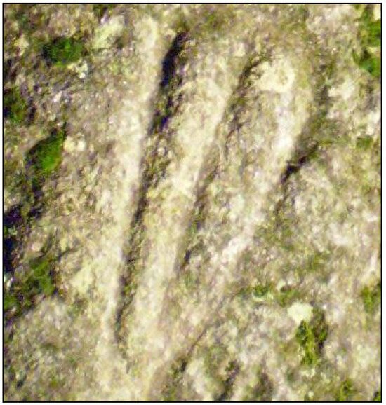
Figure 41.
Vulva resembling deer track, Track Rock 1 (Jannie Loubser).
Cherokee comments on the vulva forms at Track Rock are unfortunately lacking, conceivably because Mooney (1900, pp. 279, 284) omitted “vulgar” details they shared with him. Regardless, the short vertical lines that are attached to the dorsal ends of at least eight vulva-forms at Track Rock could very well be depictions of menstrual blood giving rise to babies, especially where the blood meets damp or watery surfaces (Grantham 2002, pp. 16, 98, 100, 242). For example, rock markings and tiny footprints on a boulder along the Pigeon River trail that Judaculla and his menstruating wife followed looked “as if a baby had been born there” (Mooney 1900, p. 339). A specific link between the life-giving powers of menstrual blood and human footprints can be seen in a Muskogee account of an old woman collecting blood from her track in a “hard and smooth” path, possibly rock, that developed into a baby boy (Grantham 2002, pp. 250–51). The meaning and function of the vulva-shaped petroglyph motifs among the Cherokees remain unclear. Still, judging by the tight connections between tracks and procuring game animals from members of Judaculla’s extended family, the vulvas were conceivably marks made to acquire fertility from powerful female spirit beings, such as Selu and Judaculla’s wife. After all, blood produced from actions of both these female spirit beings, from washing a deer carcass in Selu’s case, gave rise to babies after touching wet surfaces (Mooney 1900, pp. 242, 338, 432). This notion relates to the Cherokees’ belief that killing a deer by hunting is only temporary, as the deer is resurrected from its blood drops (ibid., p. 262). The shared shapes of certain vulva forms and deer tracks possibly allude to their shared connections to the fecundity of the spirit world. The visual resemblance of certain bird tracks and vulva shapes may imply a shared connection to an abundant spirit world.
9.6. Tracks
A common denominator between deer tracks, human footprints, and vulva shapes is the life-giving power of the spirit world, hidden from the common gaze below the ground. Access to the spirit beings who control these powers is limited to certain rock surfaces, especially anomalous ones associated with water and riparian trails leading to the mountain townhouses of spirit beings. Bearing in mind that southeastern Native Americans are primarily matrilineal and matrilocal societies that rely on agricultural produce instead of hunting, a question might rightly be posed: Why do petroglyphs depict imagery associated with game animals and not domesticated plants? In this regard, it is instructive that most Cherokee and Creek accounts emphasize hunting over cultivation. For example, Selu, disguised as a corn stalk, instructs a Cherokee hunter to chew on her roots, purify in running water before dawn, and then go out to hunt deer (Mooney 1900, p. 323) successfully. As the wife of Kanati, the primal hunter and the Master of the Game in the sky dome, Selu possesses powerful hunting secrets. Like Selu, Judaculla’s wife is also known as the “Great Female.” Both are spirit beings invoked by shamans and hunters. A destroyed petroglyph boulder on the Tuckasegee River near the Kadua Mound mother town was a place where acolytes could approach the “Great Female.” Tellingly, this boulder contained the giant footprints of Judaculla and the tracks of his deer (Mooney 1900, pp. 407, 409–10). So, viewed together, these accounts strongly suggest that the dual Masters of the Game, Kanati in the Sky Dome townhouse and Judaculla in a mountain top townhouse, can be approached via their powerful spouses.
Spirit beings at various levels of the Thunderer’s extended family serve as gatekeepers, guarding access to game animals. The existence of guardians can be seen whenever Cherokee hunters approach Kanati, Selu, Judaculla, Judaculla’s Wife, and the Little People before departing on hunts. An account of Kanati’s animals being released by his two sons from behind a boulder on the northern slopes of Black Mountain and leaving their tracks on the boulder downstream conceivably refers to Gardner Rock with its multiple deer tracks. Slightly northwest and upslope from Gardner Rock is a cliff with low overhangs, which could be an entrance to the spirit world. Boling Park Rock, located on the opposite end of the Track Rock Tradition petroglyphs’ distribution from Gardner Rock, also contains multiple deer tracks. Boling Park Rock is situated within a creek bed, slightly downstream from a small grotto, providing an apt setting for deer escaping from their underground abode and leaving their tracks (Figure 42).
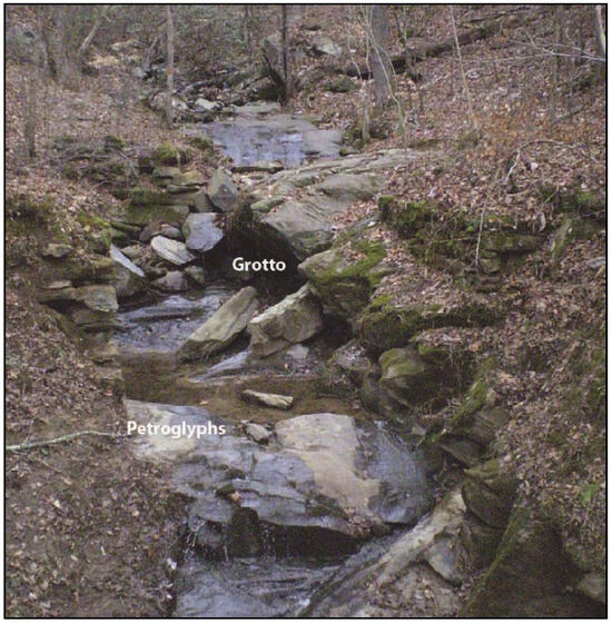
Figure 42.
Boling Park Rock petroglyphs and the grotto (Jannie Loubser).
Animals escaping from their underground abode include deer, various rodents, turkeys, and other birds (Mooney 1900, p. 243). Rodent tracks can be seen on Hickorynut Rock, for example. According to Cherokees, the multiple bird and deer tracks at the Track Rock site are imprints of animals escaping from the west (ibid., p. 219), the abode of the Thunderers. According to White (1854, p. 660), the Cherokee’s “Great Spirit” had his sanctuary within Track Rock Gap, while Creeks told Stephenson (1871, pp. 214–15) that a “Great Warrior” left his footprint on the main rock within the gap. These two statements refer to a powerful spirit being on par with Kanati and Judaculla. Large human footprints among the deer tracks at Gardner Rock could also be those left by powerful spirit beings, most likely Kanati and the Thunder Boys, based on oral traditions that link them to this area. The various Cherokee accounts mentioned above suggest that the smaller petroglyph footprints on the rocks probably include those of Little People and Judaculla’s two children.
The omnipresence and ubiquity of Judaculla as a powerful spirit can be seen in the petroglyphs. Most revealingly, Judaculla’s signature six-digit claw-like hand on Judaculla’s Rock (Parris 1950a, p. 36) and his six-digit hand on Hiwassee/Brasstown Rock (Brett Riggs 2013, personal communication) are his “maker’s marks” according to various Cherokees. According to Parris (1950a, p. 36), Judaculla chased Cherokee hunters seeking game but failed beforehand to fast and purify in Caney Creek leading up to his townhouse in the Balsam Mountains. Accompanied by lightning and thunder, the irate Judaculla made a mighty leap and landed on his claw-like hand, creating a lasting imprint on Judaculla’s Rock (Figure 43). In a related account collected by Zeigler and Grosscup (1883, p. 22), Judaculla turned into a snake. Judaculla’s slanting pupils are snake-like, while his eyes and claws are reminiscent of cats (Mooney 1900, p. 338). Judaculla’s ability to change shapes and his polydactyly are attributes associated with shamans and certain animals around the globe (e.g., Ripinsky-Naxon 1993, p. 71). It is with the nail of his right finger that Judaculla scratched a straight line across Judaculla Rock to “remind the Cherokee that death would come to all who crossed it [without first fasting and purifying in a nearby stream]” (Parris 1950a, p. 37). The prominent straight line that post-dates the handprint does not seem to change Cherokee beliefs regarding Judaculla.
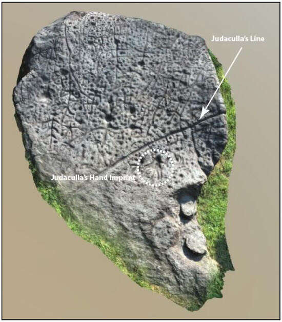
Figure 43.
Judaculla’s imprints on Judaculla Rock (Joel Logan).
Cherokee oral traditions associate Judaculla with the following five rocks: Judaculla Rock (Parris 1950b; Wilburn 1952b); Hiwassee/Brasstown Rock (Tom Belt to Brett Riggs 2013, personal communication); Track Rock Gap (Haywood 1823, p. 280); a destroyed petroglyph panel between the forks of the Pigeon River (Mooney 1900, pp. 339, 480); and a destroyed petroglyph panel on the Tuckasegee River near the Kadua Mound mother town (Mooney 1900, pp. 409–10). The close association between Judaculla’s foot and handprints and the imprints made by his game is expressed by shared place names between widely separate petroglyph locations. Both Track Rock and the destroyed rock on the Pigeon River are known as Datsun’ălâsgûñyĭ, or “Where Their Tracks Are This Way,” while the rock on the Tuckasegee River is known as Tsulâ’sinûñyĭ, or “Where the Footprint Is.” Petroglyphs associated with Judaculla are also associated with vulva shapes and later concentric circles, cross-in-circles, and spirals.
The significance of isolated human handprints, each with five digits, at River Hill Rock 1, Soapstone Quarry Rock, and Reinhardt Rock is uncertain. A Ute elder thought that handprints at Newspaper Rock in Utah are associated with women and abundant offspring (Stoffle et al. 2024, p. 29).
9.7. Figures
Whereas the petroglyph depictions of feet, tracks, and vulvas show them as separate from bodies and as if viewed from above or the front, human-like figures are depicted in their entirety, as if viewed from the front. Yet, as evidenced by Cherokee individuals who link Judaculla’s disembodied six-digited claw print on Judaculla Rock with the six-fingered figure on Hiwassee/Brasstown Rock, there is a relationship between disembodied hand imprints and fully portrayed figures.
Although the bodies of the figures resemble humans, one on Hiwassee/Brasstown Rock has a crested bird-looking head resembling a woodpecker, another one on Hickorynut Rock 2 has outstretched arms resembling wings, two “ribbed” figures—one on Judaculla Rock and the other on Track Rock 4—have outsized heads, and a figure on Sprayberry rock has a concentric ring head. All five figures are suggestive of bodily transformations. The two figures with avian features are likely to refer to humans who have transformed into birds. A figure with outstretched, downward-curving arms on Hickorynut Rock 2 also resembles a bird (Figure 44). The transformations are alluded to in a Cherokee oral tradition of a young shaman who could fly like a bird after “dressing” as a hummingbird (Mooney 1900, p. 255). The young shaman regains his human shape once he removes the “dress.” As evidenced in the account of the acolytes wishing to put on the “dresses” that Judaculla offers them so that they could finally see him (Mooney 1900, p. 34), “dressing” is an allusion to the transformation of consciousness and shape that occurs during altered states. The two large-headed figures with rib-like protrusions could be the skeletons of transformed people singing and dancing in the spirit world (e.g., Mooney 1900, p. 261).
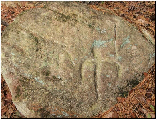
Figure 44.
Bird-looking figure, Hickorynut Rock 2 (Alan Cressler).
The association of these figures with transformations during altered states and visits to the spirit world is supported by a plant-looking figure on Judaculla Rock with an upper torso resembling the seedpod, or ovary, of a datura plant (Datura stramonium) as seen in a longitudinal-section view (Figure 45). Native Americans living in California soak roasted datura seeds, also known as jimsonweed, in water before imbibing the processed extracts as a hallucinogen (Dave Whitley 2009, personal communication). Taken in small doses, this poisonous tropane alkaloid induces realistic visual and auditory hallucinations, which include bodily transformations and feelings of flying. Considering this association with the trance experience, it is perhaps not surprising that a Cherokee visitor to Judaculla Rock claimed that one of the figures on the rock is a shaman (he did not specify which one). The concentric circle head of the Sprayberry Rock figure resembles entoptic shapes that individuals see while in a trance state (Reichel-Dolmatoff 1978b, pp. 291–92). The two upside-down figures on Track Rock 6 also suggest an out-of-body sensation.
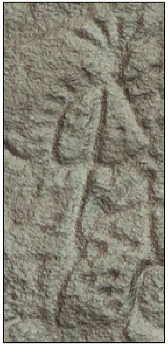
Figure 45.
Datura-looking Motif, Judaculla Rock (Alan Cressler).
Multiple figures merging with earlier meanders can be seen on Judaculla Rock, while a prominent figure on Hiwassee Fishing Rock is merged with an elongated meandering line. In the latter case, the figure appears to be an integrated part of the meander, which could signify that he is the “Long Man” of the River.
The embeddedness of figures among larger vulvas, tracks, feet, and handprints, but with slightly smaller concentric circles, suggests that concern with comparable scales in the physical world was not a priority for those who produced the petroglyphs. The discrepancy in scale can be seen, for example, by two figures touching comparatively small concentric circles, one on Hiwassee Fishing Rock and the other on River Hill 1 Rock.
9.8. Concentric Circles
When asked what the concentric circles with central cupules on Reinhardt Rock depict, Jeremiah Wolfe (2001, personal communication) said that they are most likely townhouses as viewed from above. In certain prominent towns, townhouses occurred in pairs, as suggested by the paired big concentric circles on Reinhardt Rock and smaller conjoined concentric circles at Silver City Rock, Sprayberry Rock, River Hill Rock 3, and Hiwassee Fishing Rock (see Figure 29). Paired townhouse structures on Mississippian period mound tops have been recorded archaeologically in Tennessee, for example (Schroedl 1998, pp. 70, 79). Townhouses are often covered by mounds of soil and clay or occur on top of those mounds, with postholes and stones arranged as concentric circles around a central fire (e.g., Bartram 1955, p. 297; Mooney 1900, p. 396). Copies of Bartram’s drawing of a Creek rotunda, or townhouse (Figure 46), clearly show it as having a concentric ring internal post and seating arrangement centered on a clockwise spiraling central fire (Waselkov and Holland Braund 1995, pp. 174–75). Plan maps of excavated Cherokee townhouses at Chota (Whyte 1974) and Chattooga (Howard and Riggs 1993) show the internal post holes arranged in a concentric circle fashion around a central hearth. Archaeological excavations of Middel Woodland Muskogee sites have similarly revealed concentric circle posthole patterns associated with townhouses, also known as council houses (Thompson et al. 2022, p. 710). These houses continue to be the hub of public life in southeastern Native American towns, serving as venues for political meetings, rituals, and as a place to burn the sacred fire on behalf of the entire community. Dances within townhouses, which are part of water rituals, also occur in concentric circles (Adair 1930, p. 101), while others follow in-and-out spiral shapes (see below). When early European travelers approached the cone-to-dome-shaped townhouses from a distance (Bartram 1955, p. 357), they appeared as small mountains (e.g., Sturtevant 1978, p. 200). Essentially, the shape of the townhouses mirrored the mountains inhabited by spirit beings. Some Cherokee accounts have thunder from a mountain creating a mound or townhouse (Mooney 1900, pp. 340–41; Haywood 1823, p. 280), while others have Immortal spirit beings turn a townhouse into a mountain (Mooney 1900, pp. 335, 432).
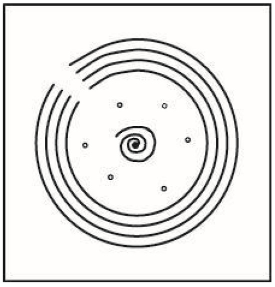
Figure 46.
Copy of Bartram’s drawing of a Creek rotunda, or townhouse.
Whereas numerous spirit townhouses are elevated in the mountains, others are submerged in river pools. A Cherokee account equates the center of a whirlpool as the smoke hole in the center of a townhouse’s roof, directly above the central fire below. It is through this central smoke hole that it is possible to see spirit beings beckoning from below (Mooney 1900, p. 347). Another account states that ever since the Cherokee townhouse of Gutsi Town collapsed into the Tennessee River, canoeists can see “the round dome of a townhouse—now turned to stone—in the water below them and sometimes hear the sound of the drum and dance coming up” (Mooney 1900, p. 336).
A Tukabahchee Creek account mentions a fasting man visiting a submerged Creek square ground used as a summertime townhouse, where “the beds were all made of snakes plaited together” (Swanton 2000, p. 491). A Cherokee traditionalist (2017, personal communication) who visited Judaculla Rock identified one of the two concentric circles on the rock as a coiled snake. Instead of contradicting the townhouse identification of Jeremiah Wolfe, associations between a snake and a townhouse occur in a variety of Cherokee accounts. For example, Cherokee shamans coil invisible snakes around townhouses for protective purposes (Mooney 1900, p. 433). While spirit beings are said to inhabit certain mountain towns, such as Judaculla and the Thunderers, others are associated with peace, including the Immortals residing in Pilot Knob (Mooney 1900, p. 341).
In contrast, those living in townhouses submerged in river pools tend to be associated with sorcery and warfare. For example, a Cherokee followed a female sorcerer to the river where “she stepped in…and there was a road under the water, and another country there just like that above” (Mooney 1900, p. 349). A Muskogee account features a young warrior diving into a river, where snakes seize him in the aquatic townhouse of a snake king (Grantham 2002, pp. 222–24). The king ultimately helps the warrior and his town defeat a marauding enemy.
A depiction of a likely aquatic Creek townhouse can be seen on the large anomalous-looking panel at Shoal Creek Rock, placed barely 10 cm above Shoal Creek’s normal level (see Figure 35 above). Considering that Shoal Creek Rock (Figure 47) is not far upstream from Etowah Mounds, a prominent Early and Middle Mississippi period site that the Muskogees, according to Creek ethnography, most probably inhabited, recourse to Creek ethnography helps identify the concentric circles-in-square motifs. The left-hand square with nine circles at Shoal Creek resembles a Creek cabin next to a square ground (open townhouse structures used in the summer) that has been documented in post-contact times (Hewitt 1939, p. 131). Usually, four open cabins surrounded a square ground, and the roof of each cabin was raised on nine posts. A fire was kindled in the center of the Creek square ground, in front of the cabins. At Shoal Creek, this fire could be the concentric circle in the center of the central rectangle. The pecked square on the opposite side of the rectangular area is in the exact location as the historically documented “Sharp House” (Hewitt 1939, p. 132). This house was erected around a central pole, like the concentric circle pecked in the center of the right-hand square at Shoal Creek. Absent from the pecked panel at Shoal Creek, however, are depictions of the other three cabins commonly found around a Creek square ground. Notably, following heavy rains, the water level of Shoal Creek rises, covering the Shoal Creek panel and temporarily transforming it into a submerged aquatic feature.
An anonymous reviewer of this paper suggested that the panel could also be a cosmogram depicting the relationship between places and spirit beings. Square grounds in Creek settlements are indeed physical “maps” of the spirit world directly above the Sky Vault, which include heavenly bodies and “spirit roads” (e.g., Grantham 2002, p. 21). This is yet another example of physical features at ground level having symbolic connotations.

Figure 47.
Shoal Creek Rock at low Shoal Creek level (Alan Cressler).
Figure 47.
Shoal Creek Rock at low Shoal Creek level (Alan Cressler).

Two meters left of this imposing Shoal Creek Rock panel is a vertical alignment of weathered petroglyph feet (Figure 48). Judging from their degree of weathering on the same rock surface as the concentric circles-in-square motifs, the feet are most probably older. The setting at Shoal Creek is reminiscent of a Cherokee account of “fresh footprints of the Little People all over the floor” where a whole company of Little People came “down to the ford of the river and cross over and disappear into the mouth of a large cave on the other side” (Mooney 1900, pp. 333–34). A low overhanging cliff a few meters west of Shoal Creek could be an abode of Little People. The exposed rock pavement immediately above the concentric circles-in-square panel and the aligned feet are covered by weathered vulva shapes. Considered together, the weathered feet and the weathered vulva shapes most probably predate the juxtaposed concentric circles-in-square panel. The decision to place the concentric circles-in-square panel at this location was probably informed, at least in part, by the presence of earlier feet and vulva-forms. In turn, the nearby small waterfall and deep river pool, immediately north of the panel, very likely influenced the placement of all these motifs; an example where petroglyphs are associated with anomalous riverine features.
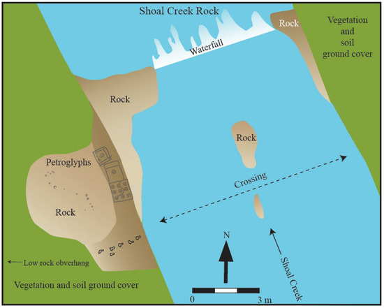
Figure 48.
Map of Shoal Creek Rock, showing the aligned feet.
The examples discussed above suggest that concentric circles and circles around a cupule are linked at various scales, ranging from entire townhouses to individual posts within townhouses. Being the central place where the fire is extinguished and renewed every harvest season, and from where most water rituals are launched, which include preparations to visit spirit beings in their distant townhouses, these townhouses are associated with fecundity, renewal, and contact with spirit beings. As locales where rites of passage tend to concentrate and contact with spirit beings are initiated, it can perhaps be expected that townhouse depictions are placed on rock surfaces at or near liminal locations, such as at changes in geology, terrain, vegetation, and water features.
Nested circles are particularly prolific on petroglyph sites along the Etowah River drainage. From west to east, these include Shoal Creek Rock, Reinhardt Rock, the three River Hill Rocks, and Silver City Rock. Early Mississippian Etowah ceramics, featuring nested circles, dated between 1050 and 600 years ago, suggesting that the nested circle petroglyphs also date back to this time range. The Etowah drainage area is also an area that falls on the southernmost extension of the Cherokee territory, where their sphere of influence overlapped with those of the Creeks.
9.9. Cross-in-Circles
The total of six sites with cross-in-circles represents a sharp decline from the 14 sites with concentric circles, suggesting that the creation of petroglyphs decreased during the Middle Mississippian period. Although the appearance of cross-in-circles could mark a shift in emphasis, it does not signify a complete break from the past. Continuity is primarily suggested by modifications of earlier motifs or incorporations of earlier motifs in the same design. For example, the vulva shape on Track Rock 1 features a horizontal line drawn through its vertical axis, transforming it into a cross-in-circle. A curving portion of an early meander on Track Rock 3 is infilled by a later cross-in-circle, and a concentric circle merges with a cross-in-circle on Sprayberry Rock.
Changing a vulva into a cross-in-circle could be significant in the light of an account where the two Thunder Boys take all night dragging their mother Selu’s bloodied head in a cross-in-circle fashion across a cleared patch in front of the townhouse and, in so doing, create corn from the drops (Mooney 1900, p. 245). Emulating this story, actual Cherokee farmers elicit the help of a shaman or do it themselves when they traverse their corn field in a cross-in-circle fashion, all the while singing songs to attract “Old Woman,” Selu, to bring corn into the field. Instead of announcing her arrival with the sound of thunder like Kanati and Judaculla tend to do, Selu makes a loud rustling sound (Mooney 1900, pp. 423–24). In these stories, the creative powers of Selu’s blood are expressed. Still, instead of creating humans or acting as a provider of game animals on behalf of her husband, her presence creates corn, the life-sustaining staple of the Cherokee and Creek peoples.
The cross-in-circle motif mirrors the fire in the center of most townhouses. This fire typically consists of four logs radiating outward at right angles from the center and is surrounded by the edge of a hearth (Hendrix 1983, p. 77). The central fire is a place of transformation. The fire in the center of a household hut is the place where shamans protect the soul of the deceased family member from malignant sorcerers who want to abduct the departing soul on its journey to the land of the west (Witthoft 1983, p. 69). Witthoft (1983, pp. 70–71) proposes two kinds of shamanic activities associated with fire. The “red” one is practiced in the presence of the townhouse fire, the ball dance fire, the war campfire, all of which involve the Thunder Brothers, collectively known as Grandfather. The “white” one is practiced in the presence of the square ground fire and domestic fires, which involve the hierarchy of female spirit beings, collectively known as Old Woman. Shamans also kindle a fire at night on the edge of a river, where apprentices enter early the next morning to purify (Fogelson 1980, p. 68). Every fire in a mother town and its affiliated satellite towns is extinguished before the annual Green Corn or Busk harvest festival. The fire is re-ignited by logs taken from the central townhouse fire of the mother town (Bartram 1955, p. 399; Wetmore 1983, p. 49). Cherokees view Corn as Selu or Mother, and Fire as Sun or Grandmother. Because Fire is considered the closest earthly manifestation of Sun, offerings of food made to Fire are deemed the most efficacious (Swanton 1987, p. 775; Wetmore 1983, p. 52). Before ball games between competing towns, a shaman representing each town prays to Ancient White Fire, Long Man River, and the Sun (Mooney 1982c, p. 31). These examples strongly suggest that like fire, the cross-in-circle is a gateway to the life-giving and life-taking world of spirits. Viewed on a global scale, cross-in-circle motifs on artifacts and rock surfaces are points of intersection between physical and spiritual worlds (e.g., Lewis-Williams and Pearce 2004, pp. 52, 180).
It is proposed that the cross-in-circle motif is an enlarged version of the central cupule within a concentric ring; both represent a central fire, as well as what it metaphorically signifies. This possibility is supported by the fact that during the Green Corn, or Busk, harvest festivals, participants dance in three concentric circles around a central fire (Adair 1930, p. 101) among other configurations, mirroring the cross-in-concentric circle design found on Sprayberry Rock and on Etowah period ceramic sherds in the area. It is accordingly proposed that, over time, the central cupule within the concentric circle motif, found on Early Mississippian ceramics and petroglyphs, became the central focus and was enlarged into a cross-in-circle motif, also found on both ceramics and petroglyphs dating to the Middle Mississippian period in the region. This shift in emphasis could coincide with a growing ritualized importance of corn, a sphere traditionally associated with females rather than the male-oriented hunting sphere.
It is worth mentioning that ascribing ethnographically informed meanings to the cross-in-circle and spiral motifs found in the petroglyphs has also been applied to ceramics (e.g., Pauketat and Emerson 1991; Van Schalkwyk 2020). The comparative-based ethnographic interpretations of spirals and implied crosses on Early Mississippian Ramey jars by Pauketat and Emerson resonate with those presented in this paper.
9.10. Spirals
Spirals are limited to three sites, all of which are located along a four-kilometer-long stretch of the Hiwassee River. Of the five spirals recorded at these sites, four are clockwise and one is anticlockwise. The anticlockwise spiral is located on Hiwassee/Brasstown Rock, three of the clockwise spirals are located on Hiwassee Fishing Rock, and the remaining clockwise spiral is located on Hiwassee Dogs Rock. As mentioned before, clockwise spiral motifs occur on Late Mississippian period ceramics and as central fires in certain townhouses, particularly those in Creek towns. In this regard, the spiral is a design that embodies the same principles as earlier concentric circles and cross-in-circles. Like concentric circles, spirals represent whirlpools, among other related phenomena. It is also the fire directly below the center of a whirlpool, where a townhouse of spirit beings can be found.
Whirlpools can both drag a person down to the land of the dead or spit a person back to the land of the living (Mooney 1900, p. 347). While working along the Hiwassee River petroglyph corridor, Cherokees told Scott Ashcraft (2000, personal communication) that the clockwise spirals are associated with death and counterclockwise ones with life. Creeks arrange split cane in a clockwise spiral at the center of their townhouses (see Figure 45 above, Bartram 1955, p. 358). These fires are left to burn following the course of the sun, from its birth in the east towards its death in the west. The alternating clockwise and anticlockwise directions of specific southeastern Native American group dances follow the same idea of moving between life and death (Marquardt and Kozuch 2015). Among Native American groups in general, the back-and-forth movements of spiritual power and humans seeking that power are not only viewed as spiral-like, but also as concentric and radial, emanating from the center and returning (Miller 1983, pp. 79–80). Viewed together, graphic metaphors associated with back-and-forth movements between the worlds of physical beings on one side and spirit beings on the other are expressed as concentric circles, cross-in-circles, and spirals, all of which are defined by a central point of transition. Perhaps not surprisingly, when viewed as a gateway between the physical and spiritual realms, the Ojibway people of the Canadian Shield regard spiral motifs as locks to theabodes of powerful shamans and spirit beings (Rajnovich 1994, p. 90).
Two petroglyphs with clockwise spirals have horn-like protrusions on their outward-facing ends, both of which are located within the Hiwassee River Corridor of petroglyphs (see Figure 29 and Figure 30 above). One is located on Hiwassee Fishing Rock, and the other is situated on Hiwassee Dog Rock. Cherokees who have seen these petroglyphs unequivocally equate them with Uktena, the horned serpent (Scott Ashcraft 2000, personal communication; and Brett Riggs 2012, personal communication). A fourth clockwise spiral, juxtaposed to the horned serpent on Hiwassee Fishing Rock, has a head-looking protrusion sticking out to the right. Cherokee say that high mountain passes, and deep river pools usually are places “where the Uktena stays” (Mooney 1900, p. 297). These are the exact locations where other lesser members of the extended Thunder family reside (ibid., p. 257), which conceivably includes the petroglyph figures juxtaposed to the Uktena depictions.
Both Hiwassee Fishing Rock and Hiwassee Dog Rock are located next to deep pools in the Hiwassee River. The Cherokee and Creek accounts discussed above refer to individual humans shapeshifting into horned serpents as they move between their sweat lodges and nearby river pools. Such accounts highlight the ability of a few experienced ritual practitioners to become the spirit beings from whom they gain favors and potent objects. For example, luminescent crystals, scales, and horns of horned serpents are prized possessions in the hands of powerful shamans and are used as potent war medicines among the Cherokees (Mooney 1900, p. 298) and Creeks (Grantham 2002, p. 26).
Until 1806, the Natchez, whose ritual practitioners are known for their war medicines, inhabited a prominent town among the Cherokees on the floodplains north of the Hiwassee River, in the vicinity of Brasstown (Mooney 1900, p. 387). According to Brett Riggs (2012, personal communication), an old Natchez town site of Aquonatuste is located on the floodplain, directly north and on the opposite side of the river, from Hiwassee Fishing Rock. Following the 1838 removal of the Cherokee and Natchez to the west, these displaced peoples’ greatest regret was leaving behind their spirit relatives in the string of pools within the Hiwassee River, south of Murphy (Mooney 1900, p. 336), an area that includes the Hiwassee River petroglyph corridor, featuring unique Uktena petroglyphs.
Peachtree Mound, which is roughly three kilometers north of the Hiwassee River petroglyph corridor, falls within the area associated with powerful war medicine. It is perhaps instructive that an arrow-looking straight line near Uktena motifs and spirals on Fishing Rock points downstream, in the direction of the mound.
Uktenas are known for their abilities to both assist and harm human beings. Among their negative qualities is their ability to devour human beings, which conceivably accounts for their heads pointing outwards in the Hiwassee petroglyphs and their clockwise spiral shape signaling death. While some shamans can turn into Uktenas, others are known to fight them, such as the powerful Shawnee shaman captured by the Cherokees, known as “Ground-Hogs’ Mother” (Mooney 1900, pp. 298–300). Inter-shamanic battles can permanently leave marks on the rocks, such as at “where the Uktena got fastened” on the Tuckasegee River near Bryson City (Mooney 1900, p. 410).
Cherokees still believe that Uktena reside in river pools. When recounting our failed attempt to thoroughly trace the petroglyphs on Hiwassee Rock 5 due to the increased turbulence of the surrounding Hiwassee River’s water, Russ Townshend, the Cherokee Tribal Historic Preservation Officer, said it was Uktena in the adjacent pool sending us a message that we should leave. Some suggested that the series of boulders with cupules and petroglyphs visible above the water level of the Hiwassee River could be the coils and cut marks of a giant spotted Uktena lurking immediately below the surface.
9.11. Two Unique Dogs and a Spiral
The Uktena on Hiwassee Dog Rock are inundated during high water levels, reminiscent of the Creek townhouse petroglyph immediately above Shoal Creek. The two dog-looking figures on Hiwassee Dog Rock, one on each side of the Uktena motif and facing towards it, recall two red spirit dogs seen playing on a riverbank in the Cherokee Qualla Reservation (Mooney 1900, p. 407). Some Creeks view dogs as gatekeepers, deciding which souls of the physically deceased can enter the Upper World once they have crossed a slippery log over a river (Bloch 2018, pp. 231–32). Below the log is a water monster, waiting to eat the souls of those who slip and fall. It is unclear whether this water monster is a horned serpent, but the story resonates with the location of the Hiwassee Dog Rock, situated in the middle of the river.
Dogs can shape shift into other entities, such as a chunky stone or a green-headed beetle (Mooney 1900, pp. 246, 311). In another account, Immortal spirit helpers living in Pilot Knob have dog paws as feet (ibid., p. 344). Dog spirits among the Cherokees and Creeks can be helpful (Mooney 1982a, p. 27; Swanton 1987, p. 773) and are known to warn people of impending dangers (Witthoft 1983, p. 71; Fogelson 1980, p. 78); however, they can also be harmful (Swanton 2000, p. 491). To assist clients, ritual practitioners are known to transform into dogs (King 1977, p. 194).
The dog motif immediately to the left of the Uktena motif on Hiwassee Dogs Rock has a tail arranged in a partial clockwise fashion, signaling life and opposition to the counterclockwise and destructive Uktena to its right (Figure 49). A short comma-looking dash immediately outside the dog’s gaping mouth could indicate vocalization. The ethnographic record mentions talking dogs. For example, following a regimen of fasting, a Creek shaman dove into a whirlpool where he ended up being killed by talking dogs who emerged from underneath a rock (Swanton 2000, p. 491). Overall, the Hiwassee Dog Rock petroglyph tableau could depict an inter-shamanic battle. Still, unlike a static depiction of an actual event, the appearance and disappearance of the dogs and Uktena petroglyphs, influenced by changing light and water levels, impart to them a life-like quality. At certain times, a layer of silt deposited by the Hiwassee River covers this and other rocks within the same corridor, creating a temporary veil that hides the petroglyphs from everyday view.
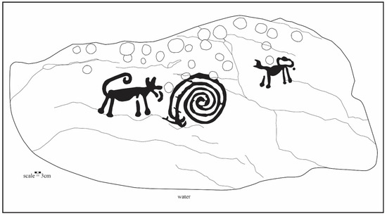
Figure 49.
Dogs and Uktena on Hiwassee Dog Rock.
9.12. Straight Lines
Due to their relatively deep carving and recent production, straight lines are more noticeable than in earlier motif categories. The longer straight lines on Judaculla Rock, Track Rock 4, Silver City Rock 1, Hiwassee Fishing Rock, and Gardner Rock connect widely separate motifs, most of them pre-dating the straight lines. These straight lines are reminiscent of the long, straight lines found in southern Paiute and western Shoshone petroglyphs in south-central Nevada, which meticulously connect motifs dating back to much earlier times (Loubser 2024). By connecting separate underlying motifs, the long lines not only signify recognition of earlier motifs but also draw attention to the connections between them. This connection is strengthened when Cherokees pour water over Judaculla Rock and let it flow down the straight lines and earlier meanders, and in the process, adding new medicines from the water to the underlying motifs and absorbing older medicines from the motifs along the way.
The long diagonal line that Judaculla drew with his right fingernail across Judaculla Rock demarcates a boundary into his domain, which is located immediately upstream from the rock in the Balsam Mountain range (Loubser and Ashcraft 2019). The rock can also be viewed as a three-dimensional map of the Balsams, with two of the most prominent lines mimicking the overall orientation of the Tuckasegee River and Caney Creek on the surrounding landscape (Loubser 2009; Loubser and Frink 2007).
Short intersecting lines forming multiple square shapes within a bigger square occur on Track Rock 6 and Turkey Track A (see Figure 34 above). Long-time residents near Track Rock maintain that Cherokees told their grandparents that these square shapes depict their log cabins (Loubser 2010; Mister Brown 2009, personal communication).
Identification of the intersecting triangles on Track Rock 6, Turkey Track Rock A, Squirrel Rock, and Allen Rock remains unclear. However, the intersecting triangles that cover much of the dome-shaped Allen Rock add to its turtle-like appearance. Considering this resemblance, it is not surprising that the alternative name for Allen Rock among residents in the area is Turtle Rock, a name considered apt by the Cherokees who reviewed the site report submitted to the Forest Service (Loubser 2011; James Wettstaed 2011, personal communication). Cherokees also equate Judaculla Rock with a turtle (Scott Ashcraft 2012, personal communication). The intersecting lines on Allen Rock give it the overall appearance of marks on a turtle’s carapace, particularly the Eastern box turtle (Terrapene carolina). The flattish top of the striated Judaculla Rock, together with its narrow, neck-like extension, gives it an overall terrapin-like appearance. Creeks believe that turtles were once bipedal (Chaudhuri and Chaudhuri 2001, p. 124), while Cherokees consider them as formerly great warriors (Mooney 1900, p. 306).
Turtles, tortoises, and terrapins appear and are used in various materials, shapes, and sizes among the Cherokees and Creeks. On a macro scale, in some Creek stories, hunters see dome-shaped hills as turtles (Grantham 2002, p. 182). On an intermediate scale, the dome-shaped roofs of some townhouses and sweat lodges, or âsĭ, are considered as the backs of turtles, while the central fires within are the turtle’s head (North Carolina Museum of History 2011). At the microscale, female dancers wear turtle shells during renewal Green Corn and Busk dances (Garrett and Garrett 1996, p. 71; Swanton 2000, p. 522)
Rocks shaped and acting like sentient turtles occur in several Cherokee stories. In one story, a Cherokee acolyte visiting spirit beings in their townhouse sits down on a rock next to a sacred fire only to find it moving, “with its head sticking out from the shell” (Mooney 1900, p. 343). In another story, a Cherokee suitor finds himself in the townhouse of his potential Thunderer in-laws, when a rock he was sitting on turned into “a large turtle, which raised itself up and stretched out its claws as if angry at being disturbed” (Mooney 1900, p. 346). Located behind Tallulah Falls in northeastern Georgia, this townhouse can be reached by walking along an old trail that bypasses Allen Rock. If turtles and terrapins are viewed as human-like gatekeepers between the underground and underwater spirit beings on one side and above-ground physical beings on the other, then rocks shaped like these other-than-human animals and modified to accentuate the resemblance could likewise be viewed as gatekeepers. The location of Turtle Rock on an old trail connecting the old Cherokee townhouse in Sâkwi’yĭ town with the Thunderer townhouse behind Tallulah Falls accentuates its gatekeeper connotation. The gatekeeper role of petroglyph boulders is explicitly stated for Judaculla Rock. Cherokee hunters who needed the assistance of Judaculla, the Master of the Game, had to stop and conduct the necessary rituals at Judaculla Rock before continuing walking along the old trail that connected Cherokee townhouses on the Tuckasegee River floodplains with Judaculla’s townhouse at the top of the Balsam Mountains. Failure to purify in the nearby Caney Creek and to properly fast resulted in punishment, while compliance guaranteed successful hunts. The intermediate landscape setting of Judaculla Rock and other Track Rock Tradition petroglyphs is discussed further in the landscape section below.
9.13. Fine Line Incisions
Fine lines that are incised with sharp metal implements come in various shapes and sizes at all five sites on which they occur. At these sites, they are always on top of other motifs wherever they overlap. Multiple tiny scratches on the surfaces of Judaculla Rock and Hiwassee Rock 5 are evidence of some interaction with the petroglyphs, such as attempts to remove and collect minute amounts of fine rock powder from them (as is presumably the case with at least some cupules at these sites).
A small, rounded head with round eyes is incised near the bottom of Judaculla Rock (Figure 50). It closely resembles an incised marine shell mask-looking gorget from Peachtree Mound (Rodning 2012, p. 38). Rodning (ibid., pp. 41, 45) estimates that the gorget comes from a mortuary context that dates to the 16th or 17th centuries. Smith and Smith (1989) suggest that such masks are related to hunting and warfare. The date range of the marine shell masks suggests that the rounded head at Judaculla Rock may be late precontact to early contact. Its mimicking of images on marine shells implies coastal connections, and its association could be with warfare. If so, then its association with the warfare symbolism of finely incised turkey tracks at Turkey Track Rock makes sense.
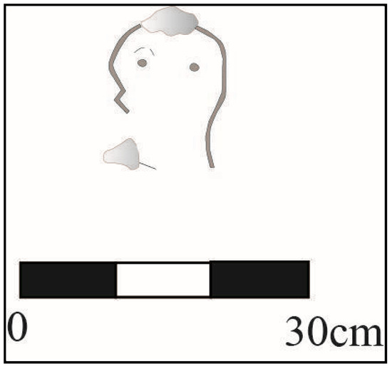
Figure 50.
Small incised head near the lower end of Judaculla Rock (flakes are shaded).
Fine line incisions are the most pronounced on the two Turkey Track Rocks (Figure 51, see Figure 36 above). The Turkey Track Rock complex is located six kilometers due south of Nikwasi Mound, both sites situated slightly above the western bank of the Little Tennessee River. Nikwasi Mound is known for containing the subterranean townhouse of the Immortals, or spirit “People Who Live Anywhere” (Mooney 1900, p. 330). Whereas Immortals who reside in other locations, such as townhouses within Pilot Knob and Blood Mountain, help Cherokees reestablish peace (Mooney 1900, p. 341), the Immortals from Nikwasi are warriors who assist Cherokees in battle (Mooney 1900, p. 336).
Sam Jessan, a representative of the Cherokee Historical Association, mentions that the two thinly incised arrows on Turkey Track Rock A point north, straight in the direction of Nikwasi (The Franklin Press and Highlands Maconian 1961). These arrows suggest a close connection between the Turkey Track Rocks and Nikwasi Mound. This connection is likely associated with warfare, given that Immortal Spirit warriors are known to have inhabited Nikwasi Mound after its abandonment in 1819 (Mooney 1900, p. 330) and the multiple turkey tracks on the Turkey Track Rocks.
Southeastern Native Americans associate turkeys with conflict and war in a variety of ways. Turkey beards refer to scalp trophies obtained in battle (e.g., Mooney 1900, pp. 287–88; Dorsey and Swanton 1912, pp. 36–37), the people-killing propensities of turkeys are recounted in various stories (e.g., Swanton 1928, p. 36), the war whoop is an imitation of a turkey’s gobble, and Chitimacha shamans use turkey beards as potent charms to bring calamity to their enemies (Densmore 1943). It is conceivably the anomalous nature of a wild turkey among birds that makes it significant to the Native Americans of the southeastern woodlands. A wild turkey is a comparatively large bird, with an average weight of approximately 30 kg. Yet, it is also a swift runner and one of the fastest-flying game birds alive; a wild turkey has been recorded flying at 88.5 km per hour (L. E. Williams 1981). Moving between its ground nest in the day and its tree-top roosts at night, a turkey is a convenient metaphor for passage between the ground and sky worlds. Moreover, their deceptively quick movements on the ground probably give these birds a reputation as an unusual adversary. It is accordingly not surprising that certain Cherokee warriors took medicine to alter their shape at will, thereby evading their opponents (Mooney 1900, p. 393). According to the concept of mimesis, a warrior could take on the abilities of a wild turkey by imitating it.
The wild turkey’s association with conflict in the ethnographic record includes a shaman’s use of the seven sharp splinters from a turkey quill to scratch players before a ball game, also known as the Little Brother of War (Mooney 1982b, pp. 18–19). Cherokee accounts have animals and spirit beings scratch rocks, such as at a place called “Where They Scratched,” bearing animal scratches, and at Ukte’na-tsuganûñ’tatsûñ’yĭ where the Uktena scratched rocks along the Tuckasegee River (Mooney 1900, pp. 410–11). The long line that Judaculla scratched into Judaculla Rock serves as a boundary marker. Still, it is one among many other likely connotations (Parris 1950b, p. 37). Tantalizingly, the blood from scratched skins inflicted during a wide range of purification ceremonies, including following birth or departing on a hunting trip, is washed away in the closest river immediately following scratching. Scratches left on certain surfaces with petroglyphs suggest that they, too, might undergo purification; the petroglyph rocks being too big to go to water necessitates bringing the water to them.

Figure 51.
Multiple scratches on Turkey Track Rock A (Lorie Hansen and Scott Ashcraft).
Figure 51.
Multiple scratches on Turkey Track Rock A (Lorie Hansen and Scott Ashcraft).

9.14. Smooth Hollows and Grooves
Whereas smooth hollows on petroglyph boulders conceivably resulted from grinding pigments and plant materials for medicines, Cherokee statements imply that Uktenas created the elongated grooves on Hiwassee Rock 5 (Figure 52, Brett Riggs 2012, personal communication). Another rock protruding into Brasstown Creek, located slightly upstream from where it joins the Hiwassee River, has similar-looking grooves to those on Hiwassee Rock 5. The Brasstown Creek rock contains cupules alongside grooves, but no other motifs, so it was not included in the petroglyph site repertoire. The activity of grinding and sharpening tools within the grooves on these two rocks may have some connection to Uktenas, a possibility that warrants further investigation. That the petroglyph surfaces were viewed, used, and interacted with in various ways is undisputed.
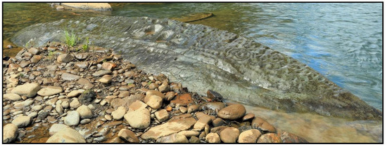
Figure 52.
Photo of Hiwassee Rock 5, showing smooth hollows (Alan Cressler).
9.15. Continued Interaction with the Petroglyph Surfaces
Cherokee accounts agree that Judaculla left for the land of the west after his prolonged stay with his human friends (e.g., Mooney 1900, p. 391). Before he left, he revealed instructions to his followers, including sacred formulas on how to conduct certain rituals and the appropriate ways to communicate meaningfully with animals and plants. These instructions can still be seen, but not necessarily understood, in a layered fashion on Judaculla Rock (Kirk 2013, p. 81).
Located on the floodplain immediately north of the rock was a Cherokee hamlet, its occupants taking care of the visitors to the rock and the rock itself on a year-round basis (Kirk 2013, p. 81). Following the forced expulsion in 1838 of most Cherokees living in the area, Cherokee delegates from west of the Mississippi River continued to visit the rock on small numbers until at least the 1890s (Wilburn 1952b, p. 21).
According to information shared by a Cherokee elder with Kirk (2013, pp. 81–82), shamans from different towns gathered at the rock at specific times throughout the year to conduct rituals, following the instructions outlined by the petroglyphs on the rock. Certain medicines could only be made on the rock, assisted by the citation of sacred formulas. Although not specified by Kirk, these medicines were probably obtained by pouring water over the rock’s apex and collecting the water at the bottom, as described above.
Cherokees told Kirk (ibid.) that medicines made at the rock were in response to a shaman’s visions calling for several towns to receive the medicines, instead of it being intended for individual consumption. Medicines were distributed to the various towns according to the map on the rock. The map is just one of many layers displayed on the rock. Another layer contains the location of the heavenly bodies. The ability to understand and use the map and its various layers has since been lost.
Traditionalist visitors to Judaculla Rock in the past used a long river cane to point at different features on the rock, understood to represent a map of the surrounding area and the wider region (Wilburn 1952b, p. 21). Using a river cane or stick to point at features on the rock is still done today by knowledgeable and observant traditionalist Cherokee visitors (Tom Belt’s communication on two separate occasions, first to Tom Hatley in 2007 and again to Scott Ashcraft in 2010). The reason for this appears to be respect for the powerful and potentially harmful spiritual energy residing within the rock. For visiting Cherokees, Judaculla Rock remains a significant physical and spiritual nexus between the sky world, the world above, and the world below (Loubser 2009, p. 304).
It is unclear whether Judaculla is still invoked during Cherokee rituals, but at least until the late 19th century, Cherokee hunters invoked Judaculla in their hunting songs. Hunters first prayed to Fire, from which he received omens, then to the river canes from which he made his arrows, followed by directly addressing Judaculla (Mooney 1891, p. 342). This custom is but one example of how Cherokee ritual was, and, among some quarters of the population, continues to be, an integrated part of everyday subsistence activities.
Visits by Native Americans from west of the Mississippi River to the Track Rock Gap petroglyphs in far northern Georgia continued to at least the early 20th century (Kay Waldrip 2009, personal communication), if not later (Perryman 1968, p. 5). Kay Waldrip’s father recalls seeing a solitary Native American visiting the petroglyph site around 1910, lingering along the rocks before ascending Thunderstruck Mountain to the west and above the site. A 19th century account identifies Track Rock Gap as “the sanctuary of the Great Spirit [Judaculla?], who is so much provoked at the presumption of man in attempting to approach so near the throne [Thunderstruck Mountain or Brasstown Bald?] of Divine Majesty, that he commands the elements to proclaim his power and indignation by awful thundering and lightning, accompanied by deluges of rain, that his subjects might be kept in awe and fear, and constrained to venerate and adore their God” (Stevenson according to White 1854, p. 660). This account is probably a variation of the Judaculla story at Judaculla Rock, particularly expressing the general Cherokee belief that if not properly approached, powerful spirit helpers, such as Judaculla, who governs from his townhouse in the Balsam Mountains of western North Carolina, can harm disrespectful hunters, through thunder, lighting, and earthquakes (e.g., Mooney 1900, pp. 335, 341, 346).
Residents living in the vicinity of Fishing Rock on the Hiwassee River of western North Carolina recall a group of Oklahoma Cherokees camping and conducting rituals near the rock in the early 20th century (Brett Riggs 2012, personal communication). Both Judaculla Rock and Fishing Rock continue to be visited by Eastern Band of Cherokee Indians living nearby.
More recently, the Eastern Band of Cherokee Indians has acquired the land surrounding the Turkey Track Rocks, located south of Franklin in western North Carolina. Apart from regular site monitoring visits, the nature of ongoing Cherokee interaction with the Turkey Track rocks is not known.
Ethnographic evidence gathered by Zedeño (2000) in the American West suggests that places, such as petroglyph locales, are created and re-created because they serve as the loci of human interactions with one another and with spirit beings. Creating additional petroglyphs or adding water for medicines to petroglyphs causes spiritual power to accumulate at those petroglyphs. Nearby plants and animals are thought to be powerful as well, as powerful places tend to attract and exchange power with other powerful elements.
9.16. Summary of the Significance of Petroglyphs and the Places Where They Occur
It should be apparent in the preceding discussion that motif categories cannot be divorced from the rocks on which they occur or from the surrounding landscape and the variety of Native American accounts and actions regarding them. Table 2 summarizes suggested associations between the motif categories, their physical representations, metaphorical allusions, associated spirit beings, and interactions with the motifs and their rock support. As can be seen, Judaculla and members of his extended matrilocal family, including Little People, which is patrilocal in the reversed spirit world, are associated with meanders, cupules, vulva shapes, figures, concentric circles, and straight lines. All these categories are associated, directly or indirectly, with hunting game animals.
Table 2.
Suggested associations of the motif categories.
Cross-in-circles, in contrast, are primarily associated with female Sun, Selu, central fires, and matrilocal concerns, such as the cultivation of domesticated corn. The unique spiral shapes that are hallmarks of the Hiwassee River Corridor are found in central townhouse fires among the Creeks but appear to be primarily associated with Uktena and war medicines. It is noteworthy that petroglyph concentric circles, cross-in-circles, and spirals occur on Mississippian period ceramics, and that petroglyph meanders, vulvas, tracks, and figures do not. The appearance of concentric circles, cross-in-circles, and spirals implies a shift of emphasis towards female-oriented activities, such as cultivation and ceramic production. Nonetheless, judging from Cherokee and Creek accounts, the importance of hunting and game animals persisted in post-contact times.
The post-contact fine line incised turkey tracks at Turkey Track rocks appear to be associated with war. Both the Hiwassee rocks and the Turkey Track rocks are located south of mound centers associated with warfare. The Hiwassee rocks are associated with the area around Peachtree Mound, known for its use of war medicines, and the Turkey Track rocks are linked to the Immortal Warriors believed to reside within Nikwasi Mound. It is perhaps not a coincidence that an arrow on Hiwassee Fishing Rock and two arrows on Turkey Track Rock point in the downstream direction where the mounds are located: Peachtree Mound on the Hiwassee River and Nikwasi Mound on the Little Tennessee River.
The chronological shift from meanders through vulvas, tracks, and figures to concentric circles and spirals suggests that the significance and role of the Track Rock Tradition petroglyphs changed over time. However, re-pecking and re-engraving sections of meanders over later motifs, as well as the reappearance of turkey tracks in post-contact times, suggest an underlying continuity rather than a complete break from tradition. Viewed together, the enduring petroglyphs within the Track Rock Tradition became, over time, the “repository for the accumulated insights of generations” (Lewis-Williams 1992, p. 26). Belief in and contact with spirit beings persisted throughout time. However, the emphasis appeared to have shifted from hunting (Woodland) to cultivation (Mississippian) and then to conflict (post-contact Mississippian).
Associated geometric petroglyph motifs enhance the transformational qualities of specific petroglyph figures. It is not contradictory to propose that the meanders, concentric circles, and spirals within the Track Rock Tradition refer to both things observed in the physical world, such as lightning bolts, townhouses, and central fires or whirlpools on the one hand, and neurologically generated entoptic phenomena observed in the spirit world of altered states on the other (Lewis-Williams and Dowson 1988; Reichel-Dolmatoff 1978a). For example, both the southern San and the Amazonian Turkano associate so-called abstract motifs (more accurately referred to as geometric motifs) with representational imagery, such as zigzags representing transformed shamans or actual lightning bolts. Moreover, petroglyphs and pictographs worldwide feature geometric motifs juxtaposed with iconographic ones, as seen in the representation of vulvas, tracks, figures, dogs, and Uktenas, alongside meanders, concentric circles, and spirals. In addition to visual associations, meanders are probably associated with sound, as suggested, for example, for the extensive Toro Muerto petroglyph site in southwestern Peru (Rozwadowski and Woloszyn 2024). A line of short grooves along the outer edges of Track Rock 4 and Gardner Rock is very likely associated with the creation of sound. When running a straight stick back and forth along the serrated edges of these two rocks, a rasping sound is created. Comparative evidence in conjunction with numerous instances of Cherokee and Creek ritual practitioners’ experiences in the spirit world suggest that meanders, concentric circles, and spirals are not merely “abstract” and representational markings, but markings that specifically recreate the physiological sensations experienced during altered states, such as loud bangs, bright flashes of light, pulsating concentric circles, and spiraling vortexes.
The petroglyphs and the locations where they are placed imply not only transition from one kind of physical terrain to another, such as the change from floodplain to hilly terrain or from normal river to deep pools, rapids, or sharp bends, but also changes in awareness, such as moving from everyday physical undertakings to ones dominated by spirit beings. To reach the spirit beings and ask them for favors in their townhouses, supplicants traveled primarily along riparian trails, journeys that took them via petroglyph boulders along the way. The following section combines archaeological knowledge of sites with relevant Cherokee and, to a lesser degree, Creek traditions to demonstrate how riparian corridors tie together towns inhabited by physical beings, petroglyphs, and towns inhabited by spirit beings.
10. Synthesis of Formal and Informed Information: The Landscape Setting of the Petroglyphs
10.1. Introduction
In the following section, nine river corridors that link physical townhouses with spiritual townhouses via a petroglyph site or sites are presented in turn, based on the amount of ethno-historic background information and physical traces of trails. The nine corridors are as follows: the Brasstown Creek Corridor, the Hiwassee River Corridor, the Caney Creek and Pigeon River Corridors, the Soucee Creek Corridor, the Little Tennessee River Corridor, the Cane River Corridor, the Chickamauga Creek Corridor, and the Etowah River Corridor (Figure 53). As will become apparent, less ethnographic information can be gleaned from the river corridors farthest removed from the central heartland of the post-contact Cherokee towns in western North Carolina. It is in the Cherokee heartland of western North Carolina that oral traditions survived most intact.
During the post-contact period, six of the river corridors had names. In 1755, the government of the South Carolina colony named six river catchments, or “hunting districts”, centered on mother towns in the Blue Ridge Mountains and surrounding foothills. In a clockwise direction from the western end, the following town units are listed: Overhill Towns, Middle Towns, Valley Towns, Out Towns, Lower Towns, and Piedmont Towns (Royce 1887, p. 142).

Figure 53.
Relief map showing the nine river corridors with petroglyphs.
Figure 53.
Relief map showing the nine river corridors with petroglyphs.

10.2. The Brasstown Creek Corridor
The most apparent link between Native American towns, trails, petroglyph sites, and spirit houses is the Choestoe Trail in the mountains of far northern Georgia, which was considered, at the time of European incursion, to be at the southern end of the Valley Towns (Wynn 1990). Track Rock Gap lies at the uppermost headwaters of the north-flowing Brasstown Creek, a tributary of the Hiwassee River. An 1832 land lottery survey map of Indian land in the then-Cherokee County, Section 1, District 17 (Torrence 1832), shows the Choestoe Trail running through the gap (Figure 54). From the gap, it runs through the upper Brasstown Creek valley in a northeasterly direction but turns more to the east where it joins the Hiwassee River valley (see Figure 54). Roughly six kilometers north of the Track Rock petroglyph complex is Young Harris Rock, followed by Soapstone Quarry Rock immediately to its north, and then Golf Course Rock roughly two kilometers north of Golf Course Rock. The original location of Chatuge Rock is uncertain, as is the direction of the Choestoe Trail north of the Georgia State line; however, Chatuge Rock may have once been located on the trail. Taken together, the four petroglyph sites in the upper Brasstown Creek catchment constitute the Brasstown Creek Corridor.
Located on a floodplain west of Brasstown Creek and adjacent to Golf Course Rock is the Brasstown Valley archaeological site complex, with components dating from the Early Archaic period to the early contact period of the Cherokee (Cable and Gard 2000). At the confluence of Shooting Creek and the Hiwassee River was another significant Cherokee settlement, known as Cattoogachaye, which became inundated with the completion of the Chatuge Dam in 1942.

Figure 54.
Relief map showing petroglyph sites along the Brasstown Creek Corridor.
Figure 54.
Relief map showing petroglyph sites along the Brasstown Creek Corridor.

The oldest known published reference to Track Rock at the head of the Brasstown Creek Corridor was made by a prominent Cherokee, Charles Hicks, to a prominent Tennessee judge and antiquarian, John Haywood (Haywood 1823, p. 280). According to Hicks’ account, a failed ritual in a townhouse associated with a mound in the vicinity of Brasstown, which is most likely Peachtree Mound, prompted Judaculla, his wife, and their first child to move to their spirit townhouse within Brasstown Bald, variously called Echia, Echoee, Etchowee, or Enotah in the Cherokee language, the highest peak in northern Georgia. On their way to Brasstown Bald, presumably along Brasstown Creek, Judaculla and his small family “made the tracks in the rocks which are to be seen there” (Haywood 1823, p. 280). This account is a variation of Judaculla and his small family leaving Kanuga Town on the Pigeon River to visit his spirit townhouse within Tanasee Bald, known as Tsunegûñyĭ among the Cherokees, located at the apex of the Balsam Mountains. This similarity is expressed in the identical name, Datsun’ălâsgûñyĭ, or “Where Their Tracks Are This Way”, given to the extant petroglyphs within Track Rock Gap and the now destroyed petroglyphs in the fork of the Pigeon River. Petroglyphs with tracks sharing the same name and being located between a townhouse/sweat lodge on the one end and a spirit townhouse on the other imply that the Pigeon River Corridor northeast of Tanasee Bald mirrors the Brasstown Creek Corridor northeast of Brasstown Bald. With roughly 190 km separating the two corridors, the similarities are indicative of a widely shared cultural tradition.
The precursor of the current Arkaqua Trail probably branched off from the main Choestoe Trail in Track Rock Gap and headed east towards Brasstown Bald along a narrow ridgeline (see Figure 54). It is near the first ridge east of Track Rock Gap, along the Arkaqua Trail, that Carey Waldrip, a resident living near Track Rock Gap, found a natural vent that Mooney (1900, p. 332) described as a small, chimney-like hole. Waldrip found that on freezing winter mornings, relatively warm and moist air emanates from a crevice in a boulder as visible vapor. Cherokees believed that the vapor was caused by the Immortals having a townhouse and fire directly under the rock. Apprehensive Cherokee hunters who stopped at the vent to rest on winter mornings did not stay long.
On a ridge immediately south of the Arkaqua Trail is a large, piled-stone complex comprising walls, terraces, and small piled-stone mounds of various shapes and sizes (Loubser and Frink 2010). This complex, which dates to the Early Mississippian period, was reported by Stevenson in 1834 (White 1854, p. 658). Supplicants who ascended the slopes of Brasstown Bald almost certainly were aware of this complex. The nearby Choestoe Trail, which connected settlements in the Georgia foothills to the south with those in the mountains of western North Carolina to the north, brought additional foot traffic to the area, lending greater public visibility to the petroglyphs and the piled stone feature complex within Track Rock Gap. It is likely that the Choestoe Trail once connected the Brasstown Creek Corridor to the Hiwassee River Corridor to the northwest.
10.3. The Hiwassee River Corridor
An approximate 20-kilometer-long “empty” stretch of the Hiwassee River valley, without any known petroglyph sites, separates the Hiwassee River Corridor from the Brasstown Creek Corridor downstream. Like the Brasstown Creek Corridor, the Hiwassee River Corridor falls within the area known as Valley Towns to Europeans. The petroglyphs within the Hiwassee River Corridor extend almost three kilometers from Fishing Rock to the confluence of the Hiwassee River and Brasstown Creek (Figure 55).
Three of the five boulders within the Hiwassee River Corridor are concentrated at a point where the river makes an unusually sharp turn northwards towards Peachtree Mound (see Figure 54). This abrupt change in the river’s course is also where Brasstown Creek joins it from the south, in the direction of Brasstown Bald. It is not clear if the petroglyphs are connected to Peachtree Mound to the north or Brasstown Bald to the south, or if they are connected to both. Mountain tops, such as Tsuwa’tel’da elsewhere among the Cherokees (Mooney 1900, pp. 343–44), and mounds, such as Nanih Waiya among the Creeks (Adair 1930, pp. 355, 406). These latter two sites are known to be end destinations for supplicants or “pilgrims” seeking assistance from spirit beings. Whereas Charles Hicks links the nearby town of Brasstown to Brasstown Bald in his narrative of Judaculla’s journey, the war medicine connotations of the Uktena and dog petroglyphs link them to the nearby Cherokee and Natchez towns, known for their use of war medicines. A downstream journey by canoe could bring Peachtree Mound within easy reach of the petroglyph corridor. Riparian links with both the mound and the mountain, located in opposite directions, are possible, too.

Figure 55.
Relief map showing petroglyph sites along the Hiwassee River Corridor.
Figure 55.
Relief map showing petroglyph sites along the Hiwassee River Corridor.

10.4. Caney Creek and Pigeon River Corridors
Various accounts imply that hunters and other supplicants living in towns along the Tuckasegee River floodplain, including Cullowhee Town, followed Caney Creek via Judaculla Rock to reach Judaculla’s townhouse in Tanasee Bald (Parris 1950a; Wilburn 1952b). European settlers considered this stretch of the Tuckasegee River as the Out Towns. On the opposite side of Tanasee Bald, oral traditions recall Judaculla and his family leaving Kanuga Town for his townhouse, following the Pigeon River via the destroyed Track Rock petroglyphs (Mooney 1900) (Figure 56). By the time of large-scale European settlement in the Pigeon River Valley, the towns were for the most part abandoned. Therefore, for this report, the area is referred to as the Pigeon River Towns.
Having researched various placenames related to Judaculla, Wilburn (1952a) mentions Judaculla’s Old Fields and Judaculla Mountain, both located on the west-facing slopes of Tanasee Bald and the surrounding Balsam Mountains. Following interviews with Cherokee traditionalists, Ashcraft (2014) added Judaculla’s Judgement Seat (called Devil’s Courthouse by early European settlers) and the Looking Glass granite dome to the list of places associated with Judaculla. Knowledgeable Cherokees view the Balsam Mountains upslope and east of Judaculla Rock as “Judaculla’s Domain,” a potent precinct within which it is advisable for people not to linger too long and certainly not to live permanently (Loubser and Ashcraft 2019, p. 265).
Judaculla appears to have had more than one townhouse in the Balsam Mountains, which includes at least Tanasee Bald and Judaculla’s Judgement Seat. Judaculla’s Judgement Seat (erroneously called Devil’s Courthouse by European settlers) is a massive rock outcrop on a ridge spur roughly eight kilometers south of Tanasee Bald, with an imposing view over the surrounding terrain. Zeigler and Grosscup (1883, p. 21) mention a “great medicine-man” visiting Judaculla in his cave-like townhouse by walking along a precipitous ledge. This physically dangerous act is reminiscent of Judaculla’s wife and children being able to walk up and down a vertical cliff below his Tanasee Bald townhouse (Mooney 1900, p. 341).
Of likely significance are the different directions that are taken to Judaculla’s townhouse in the Balsam Mountains. When Judaculla and his family walk southwest towards his townhouse along the Pigeon River Corridor, he is separated from other human beings physically. In contrast, physical humans walk northeast along the Caney Creek Corridor to supplicate game animals from the Master of the Game. The southwest movement is that of physical concealment and death, whereas the northeastern movement is that of spiritual exposure and life. It is telling that when Judaculla and his family move towards Brasstown Bald, they also move in a southwesterly direction, the Darkening Land of Spirit Beings. In a subsequent account, a young Cherokee hunter travels in a northeasterly direction along the Soucee Creek Corridor to interact, albeit unsuccessfully, with spirit beings.

Figure 56.
Relief map showing petroglyph sites along Caney Creek and the Pigeon River Corridors (according to oral traditions, riparian trails followed drainages in red).
Figure 56.
Relief map showing petroglyph sites along Caney Creek and the Pigeon River Corridors (according to oral traditions, riparian trails followed drainages in red).

10.5. The Soucee Creek Corridor
Soucee Creek is featured in an account of a young Cherokee who wanted to marry Thunder’s sister (Mooney 1900, pp. 345–47). This account takes place in an area known as the Lower Towns. In the account, a young warrior who partakes in an all-night dance within the townhouse of Săkwi’yi Town, next to Soucee Creek, falls in love with one of two sisters with beautiful hair. Unbeknownst to the warrior, the sisters are spirit beings with the ability to appear and disappear at will. To visit them in their townhouse, the sisters demand that he fast for seven days. After his fast and following another all-night dance, at daybreak, the time of going to water, he reluctantly follows the two women into Soucee Creek. Reading his thoughts, as spirit people do, the sisters assure him that “this is not water, this is the road to our house” (ibid., p. 345). As he steps into the water, it turns into a trail of soft grass. The riparian trail leads them to the Tallulah Falls within the Tallulah River, roughly 10 km northeast of Săkwi’yi town (Figure 57). As he stands on the threshold of a cave’s entrance behind the waterfall, the warrior is met with the sound of distant thunder. The cave habitation of his would-be in-laws, the Thunders1 family, is a terrifying place, where the sisters turn bald, a rock on which he is offered a seat turns into an angry turtle, and his prospective brother-in-law appears at the entrance with a great thunderclap. The failed suitor finds himself outside after lightning from his prospective brother-in-law’s eyes knocks him out. As he regains consciousness, the young warrior finds himself in the tranquil creek again; the snakes that twisted around his wrists at the cave’s entrance having turned into laurel bushes. After his return to Săkwi’yi Town, his relatives inquired why he had been away for such a long time. Seven days after he tells them about his terrifying experience, he dies, for no ordinary person can come back from visiting spirit beings and tell it and live.
The account has all the hallmarks of terrifying altered state experiences documented among other Native American groups, notably, a waking nightmare of a Crow warrior living on the Plains described by Nabokov (1982, p. 148). Unlike the Crow warrior’s recollection of his waking nightmare, the Cherokee account of the suitor is not necessarily an event in a particular person’s life, but rather an allusion to the average Cherokee male’s uncomfortable relations with his matrilocal affinal family as well as reversals and potential chaos associated with spirit world visions.
Of significance is the turtle-shaped Allen Rock’s location next to an old, eroded trail connecting the headwaters of Soucee Creek with Tallulah Falls (Figure 57). Also known as Turtle Rock, the turtle-shaped petroglyph boulder (see Figure 40) conceivably served as a stopping point before supplicants could proceed to the townhouse of the powerful Thunder’s family, where their wishes could be granted or rejected.

Figure 57.
Relief map showing Allen Rock along the Soucee Creek Corridor.
Figure 57.
Relief map showing Allen Rock along the Soucee Creek Corridor.

10.6. The Little Tennessee River Corridor
The Turkey Track Rock site is roughly five kilometers south of the Nikwasi Mound and seven kilometers north of the Coweeta Creek site (Figure 58). A Cherokee townhouse on top of the Nikwasi Mound was the focus of the surrounding Nikwasi Town on a floodplain west of the Little Tennessee River in the 18th century (Steere 2015, pp. 205–6). The town dates to the Early Mississippian period and 1819, with the mound becoming a vacant ritual center roughly 30 years before Mooney conducted his fieldwork in the area. The Coweeta Creek site, located to the south and upstream from Nikwasi Mound, dates from the mid-15th century to the early 19th century (Ward and Davis 1998). The Coweeta Creek site, the Turkey Track site, and the Nikwasi mound site are all located on the western side of the Little Tennessee River. These sites are part of what has been labeled the Middle Towns.
The placement of the post-contact Turkey Track Rock site between the Coweeta Creek site and Nikwasi Mound along the Little Tennessee River valley, together with the two incised arrows on Turkey track Rock A pointing towards Nikwasi Mound, suggest that this petroglyph locale served as a stopping point for supplicants from upstream towns traveling to the downstream mound with its Immortal spirit warriors (Mooney 1900, p. 330). Such a journey would be reminiscent of the one proposed down the Hiwassee River Corridor to Peachtree Mound. Cherokees told Mooney (1900, pp. 396–97) that an everlasting townhouse fire still burns at the bottom of the Nikwasi Mound and that the normally invisible Immortals could only be seen within the precincts of Nikwasi Town, presumably only to those with the necessary credentials.

Figure 58.
Relief map showing Turkey Track rocks along the Little Tennessee River Corridor.
Figure 58.
Relief map showing Turkey Track rocks along the Little Tennessee River Corridor.

10.7. The Cane River Corridor
No documented Cherokee account explicitly mentions Gardner Rock; the petroglyph boulder located immediately north of a creek that empties into the nearby Cane River to the south. The source of the Cane River is Attaculla Mountain, the Cherokee name for Mount Mitchell, which is located towards the southern end of the majestic Black Mountain range (Figure 59). It is perhaps to be expected that the powerful Cherokee deity, Kana’tĭ, kept his game within Attaculla Mountain, bearing in mind that it is the highest peak not only in the Blue Ridge Mountain range (Mooney 1900, p. 432) but also in the United States west of the Rocky Mountains. The Cane River connects the Early Mississippian to the Late Mississippian Cane River site (Schubert 2017), five kilometers west of Gardner Rock.
It is in this area where the two sons of Kana’tĭ, the primal and transcendent Master of the Game among the Cherokees, moved a heavy rock away that blocked the cave where Kana’tĭ kept his game (Mooney 1900, pp. 243, 249). Upon opening the cave, the animals rushed out and scattered in all directions, leaving multiple imprints. The multiple animal tracks on Gardner Rock are probably indicative of what Cherokee supplicants can expect when they proceed farther up the Cane River drainage towards Attaculla Mountain.
The paucity of ethnographic information regarding Gardner Rock can be ascribed to two likely factors. First, any account that mentions the origin of game animals was held so sacred that, before hearing it from a specialist religious practitioner, a person had to be purified by fasting in the townhouse and then go to the closest river to purify themselves (Mooney 1900, p. 431). Secondly, Black Mountain is generally considered to demarcate the easternmost limit of Cherokee habitation (Scott Ashcraft 2021), citing information supplied by Tom Belt), an area far removed from the post-contact Cherokee heartland. Gardner Rock is currently the northernmost known Track Rock Tradition petroglyph site, and no petroglyph boulders exhibiting similar motifs have yet been reported to the north and east. Due to its location on the outer fringes of Cherokee settlement during the early contact period, no town designation has been given to the area. For this report, the area is referred to as Cane River Towns.

Figure 59.
Relief map showing Gardner Rock along the Cane River Corridor.
Figure 59.
Relief map showing Gardner Rock along the Cane River Corridor.

10.8. The Chickamauga Creek Corridor
Hickorynut Rock and Squirrel Rock are located on a west-facing ridge toe, between Tray Mountain to the north and extensive Native American town sites on the Chattahoochee River floodplain to the south (Figure 60). Together, this area was considered the upper reaches of the Lower Towns.

Figure 60.
Relief map showing Hickorynut and Squirrel Rock along the Chickamauga Creek Corridor.
Figure 60.
Relief map showing Hickorynut and Squirrel Rock along the Chickamauga Creek Corridor.

There are several mounds located on the Chattahoochee River floodplain, among which Kinemer Mound and Nacoochee Mound are the best known. The Kinemer Mound site comprises two mounds; the eastern mound is the largest of the pair and dates to the Late Woodland period (M. Williams 1999). The Nacoochee Mound and its surrounding floodplain yielded deposits spanning the Early Woodland through the Middle and Late Mississippian periods, as well as the contact period of early European visitation (Langford 2002). Before its destruction, the Lumsden piled stone mound was located on high ground east of the Chickamauga Creek. Excavations of this mound (Wauchope 1966) yielded artifacts dating to the Late Mississippian period (Ledbetter et al. 2006, p. 385). Lumsden Mound shared specific attributes with a prominent Early Mississippian stone mound on the eastern slopes of Track Rock Gap (Loubser and Frink 2010).
The north-to-south-aligned Chickamauga Creek valley provides the most likely route linking the mound sites and surrounding Cherokee towns with Tray Mountain (see Figure 60). An eroded trail, which runs straight up the central crest of a ridge toe, links the upper reaches of the creek with Hickorynut Rock and the ridge crests beyond, likely up to Tray Mountain. Although no known oral traditions exist regarding a likely trail along this corridor, its proposed placement between populated floodplain and prominent mountain top mirrors those of the Choestoe Corridor, the Caney Creek and Pigeon River Corridors, and the Soutee Creek Corridor.
10.9. The Etowah River Corridor
The six petroglyph sites located within the upper Etowah River catchment are the only ones within the Track Rock Tradition that fall within the foothills, or Piedmont, of northern Georgia. A gap of roughly 60 km separates these Piedmont petroglyphs from the ones in the Blue Ridge Mountains to the northeast (see Figure 1 above).
The following four petroglyph sites are located along the Etowah River, between the Etowah Mounds site to the west and Sawnee Mountain to the east: Boling Park Rock, Reinhardt Rock, River Hill Rock, and Silver City Rock. Perhaps significant is that the headwaters of the Etowah River are the imposing Amicalola Falls and Black Mountain to the northeast (Figure 61).
The two additional petroglyph sites that fall within the upper Etowah River Catchment are Shoal Creek to the north and Sprayberry Rock to the south. Shoal Creek Rock is located on a small waterfall three-quarters of the way up Cagle Mountain. In contrast, Sprayberry Rock is located immediately above the headwaters of Little River, halfway between Sweat Mountain to the east, Blackjack Mountain to the south, and Kennesaw Mountain to the west.
Although prominent old trails that connect distant regions have been recorded for the area, virtually no known ethnographic information has been forthcoming regarding the six petroglyphs within the upper Etowah River catchment. The only known hint of ethnographic information is Jones’ (1873, p. 337) suggestion that the petroglyphs on Silver City Rock are the work of Cherokees. However, there is consensus that the Muskogee Creek predominantly inhabited the Etowah Mounds and numerous other mound sites in western Georgia at the time of the Spanish entrada (e.g., W. L. Williams 1979). For this report, the known early contact Cherokee sites in this area are collectively referred to as the Etowah Towns.
Whitley and Hicks (2003, p. 78) mention five major trails that traversed the upper Etowah River catchment during early post-contact times (Figure 60). These are the Hightower/Etowah Trail, the New Echota Trail, the War Woman’s Trail, the Alabama Road/Tugaloo Trail, and the Cherokee Federal Road. River Hill Rock and Silver City Rock are located near the intersection of the Tugaloo Trail, War Woman’s Trail, and the Cherokee Federal Road.
From west to east, Wauchope (1966, p. 222) mentions the following post-contact Cherokee towns along the upper Etowah River: Sixes Old Town, Red Banks Village, Hickory Log Village, and Long Swamp Village. Prominent Woodland and Mississippian period sites tend to be concentrated along a section of the Etowah River floodplain in the vicinity of the Etowah Mound complex, which includes the Middle Woodland Leake Mound complex slightly to the west (Keith 2010) and various mound sites to the east on floodplains inundated by the Allatoona Dam since 1949. Boling Park Rock is the first known petroglyph site to the west of Allatoona Lake’s easternmost extent. Of the six petroglyph sites within the upper Etowah River catchment, four occur along the Etowah River, and two occur along the most prominent tributaries of the Etowah: Shoal Creek to the north and Little River to the south.

Figure 61.
Relief map showing petroglyph sites along the Etowah River Corridor (Tugaloo Trail marked in red).
Figure 61.
Relief map showing petroglyph sites along the Etowah River Corridor (Tugaloo Trail marked in red).

In contrast to the linear arrangement of 17 Track Rock Tradition petroglyph sites along river corridors described above, the six petroglyph sites within the upper Etowah River catchment are separated into three of the four cardinal directions: north, east, and south. A petroglyph site that marks the western direction may now be inundated under Allatoona Lake. In the absence of direct ethnographic accounts but in the light of the other accounts given above and the associated archaeological evidence, it is conceivable that a past connection existed between the mounds along the Etowah River and the distant waterfalls and mountains mentioned above (see Figure 61).
10.10. Summary of the River Corridors
Native American trails are enduring physical evidence of Indigenous knowledge and use of the landscape. Many are sacred to Native Americans because they lead to places with spirit beings and spiritual power (Stoffle et al. 2002, p. 57). It is virtually a pan-North American belief that when a ritualized place, such as a spirit townhouse on a prominent mountain, is networked into a landscape, the surrounding area is too powerful to approach without proper ability, experience, preparation, and stopover points (Stoffle et al. 2002, p. 29). Stopover points on the way to powerful locations, such as petroglyph sites in the Blue Ridge Mountains and Piedmont, are located along trails followed to enter the buffer zones surrounding the spirit townhouses.
Table 3 and Table 4 summarize petroglyph sites and associated corridors, towns of origin, and destinations. Table 3 lists sites that are mentioned in Cherokee accounts, while Table 4 lists sites where no associated Cherokee accounts could be found.
Table 3.
Summary of Blue Ridge petroglyphs mentioned in Cherokee accounts.
Table 4.
Summary of Petroglyph Boulders Located between Mounds and Prominent Mountains.
An assessment of the examples discussed suggests that, instead of always following major trails, petroglyph sites consistently follow riparian corridors, ranging from populated floodplains to remote mountain summits or abandoned mounds. At specific topographic changes, such as ridge lines, trails to spirit houses leave the tight riverine corridors and follow abutting ridge crests instead. Correspondence between major trails that link distant settlements and smaller trails leading to specific mountain tops or mounds only occurs when both happen to follow the same riparian route before parting ways.
The following Cherokee statement documented by Mooney (1900, p. 240) summarizes the underlying idea that guided the evidence presented in this paper: “the streams that come down from the mountains are the trails by which we reach this underworld, and the springs at their heads are the doorways by which we enter it, but to do this one must fast and we go to water and have one of the underground people for a guide.” The actions informed by this idea are expressed as specific features on the landscape that are graphically depicted in Figure 62. The Cherokee statement conveyed to Mooney adds that the spirit world is a mirror of the physical one, save that things are reversed. The reversal is a reason why supplicants travel upriver to the remote spirit townhouses of Kanati and Judaculla, notably, Attakulla Mountain and Tanasee Bald, respectively, so that they can ask for surplus game animals in the spirit world whenever game is scarce in the physical world. When conflict and uncertainty reigned in towns, entire communities would walk to spirit houses to supplicate for peace, such as visiting the Immortals in Pilot Mountain. In later times of increasing conflict, supplicants appeared to travel downstream to specific abandoned mound centers, notably, Peachtree Mound and Nikwasi Mound, to request assistance from the Immortals in war.
The following four transformations are necessary for a journey upstream or downstream along trails that mostly follow river corridors but diverge to ridgelines when narrow riparian terrain becomes prohibitive:
- The first transformation involves prolonged dancing and fasting within a townhouse, with a sacred central fire at the focus, accompanied by repetitive circular movements. The overnight physical exhaustion of a supplicant is intended to enhance awareness of spirit beings, such as the two sisters who visit the young warrior in Săkwi’yi Town’s townhouse.
- The second transformation involves early morning purification in a nearby river, sometimes preceding by scratching the arms with sharp animal bones or teeth (this is also part of the Green Corn and Busk rituals that are common throughout the southeastern United States). A purified supplicant faces the rising sun and then proceeds on the journey to the townhouse of spirit beings, following a riparian trail, at times walking or canoeing (the latter if heading downstream, such as along the Hiwassee and Little Tennessee Rivers).
- The third transformation is a “rest” stop at a petroglyph site, where certain rituals are conducted and sacred formulas are recited. Failure to comply with proper ritual requirements is likely to result in bad encounters with spirit beings once a spirit townhouse is reached, such as Judaculla pursuing disrespectful hunters.
- The fourth transformation of entering the townhouse of spirit beings is a dangerous one and seems to be reserved only for a select few ritual practitioners, notably, shamans and perhaps priests (the latter before the populace ousted them). This transformation involves entering a trance-like state and communicating with spirit beings, who are, for the most part, not audible or visible in the everyday physical world. Ordinary people can join these journeys. Still, like Judaculla’s brother-in-law, they must be content to stay outside the townhouses of powerful spirit beings or risk terrifying encounters that can result in death.
Each transformational step signifies, both literally and metaphorically, a shift in consciousness, which culminates in a completely altered state of consciousness once a spirit townhouse is entered. During any of these transformational stages, animated non-human beings can be of assistance or a hindrance. For example, Little People can show travelers the way or lead them astray. Uktenas can act as gatekeepers at certain river pools en route to the spirit townhouses. Once within a spirit townhouse, rocks can serve as convenient seats or morph into menacing turtles.

Figure 62.
Idealized top view of the relationship between townhouses, rivers, and petroglyphs.
Figure 62.
Idealized top view of the relationship between townhouses, rivers, and petroglyphs.

The above four transformational stages conceivably involved all the petroglyph sites within the Track Rock Tradition. Such shared transformations suggest a significant inter-river corridor connection, or an interaction sphere, that spans the southern Blue Ridge Mountains and the foothills immediately south of the mountains, a region that measures 300 km northeast to southwest by 100 km northwest to southeast. It is this regional setting that the final section addresses.
11. Synthesis of Archaeological and Ethnographic Information: The Regional Setting of the Track Rock Tradition Petroglyphs
Water not only connects distant places within the same river catchments, but its ubiquitous nature transcends time and space differences. Cherokees believe that the world was once entirely water and that it will ultimately return to water again (Mooney 1900, p. 239). Various Creek groups believe only water and sky existed before the emergence of dry land (Grantham 2002, p. 14). Flood stories among the Creeks have apocalyptic connotations connected to people increasingly neglecting rituals (ibid., p. 19).
Examples in this paper suggest that birth and rebirth occur in watery media, especially those associated with rivers. River, personified as Long Man, is born in the high points of the landscape. Shamans and other supplicants seeking the help of spirit beings inhabiting high points are reborn in townhouse rituals and immerse themselves in a nearby river. A successful journey of a soul belonging to a physically deceased person to the spirit world in the West involves passing over a raging watery chasm with the help of shamans.
Like most Native American groups, the Cherokees and Creeks maintain that they had deep-rooted connections, understandings, and interactions with the land when the Europeans first encountered them. Long-standing co-dependence with human and non-human beings fostered a traditional knowledge where the division between secular and spiritual relationships disappears, as does the distinction between survival activities and ritual activities. To elicit the assistance of powerful spirit beings in achieving success with fertility, finding partners, hunting, games, gambling, raiding, weather control, and cultivation, the Cherokees and Creeks have incorporated travel to the townhouses of these spirit beings into their ritual repertoire. Carroll (2007, p. 70) ascribes such journeys, or “pilgrimages,” to a cultural logic that “affirms the collective valuation of particular places and social memories inscribed in the landscape.”
The Cherokee believe that water connects places separated by great distances, as illustrated by a 2010 interview that Scott Ashcraft had with Tom Belt, a Cherokee linguist and traditionalist, at Judaculla Rock. During their revealing conversation, Belt told Ashcraft that “a little bit of this water [from the spring below the rock] makes its way to the ocean, but this water doesn’t become part of the ocean, the ocean becomes part of this water- the ocean is born here.”
Stoffle et al. (2002, p. 34) note that “distance is not a limiting factor when it comes to an individual Indian person traveling to a power place to acquire spiritual power, new guidance, or renewal of their powers.” Capable and experienced ritual practitioners can travel great distances overland quickly, following river courses divided by mountain gaps, as recounted in the journey of the powerful Shawano shaman known as Ground-hogs’ Mother (Mooney 1900, p. 299) from Tennessee in the northeast to Georgia in the southwest. By shapeshifting into a bird, a shaman can cover vast distances through the sky (ibid., p. 255). Entire towns are said to purify in water so that they can travel far towards the abodes of potentially helpful spirit beings (ibid., pp. 335–36). The greater the distance traveled, and the more menacing the obstacles encountered along the way, the greater the chance of receiving a spiritual award at the endpoint. Preparatory rituals, especially fasting and purifying in water, are essential starting points.
Native Americans across North America view water as a necessary purifying agent for transformation, while some, like the Cherokees, believe water speaks with a breath that only a few understand. As a sentient entity and a medium through which other sentient entities move, water and the beings within it at times come to people, particularly during dreams and visions, rather than people constantly having to go to water. Native American accounts suggest that water is web-like, permeating the skies, the ground surface, and the subterranean layers, with the different strands intersecting at specific points within this layered cosmos (Miller 1983, pp. 78–79). Anomalous places where water emanates from, accumulates at, and rapidly changes course or drops in elevation are where physical beings and spirit beings tend to meet and interact.
Native Americans ascribe great significance to prominent mountains as places where water is believed to be passed from the spirit world to the physical one. High mountains are also places where water radiates outwards in a web-like fashion down their valleys. Water and the beings moving within it can travel from one valley to the next through subterranean passages, culminating in an expansive inter-valley web of physical and spiritual connections. Spirit beings and transformed people traveling through the sky, often accompanied by moving thunderstorms and lightning, are another way the web connects different places across a vast region.
Notably, the fact that Gardner Rock and Boling Park Rock, with their multiple deer tracks, occur on opposite ends of the Track Rock Tradition petroglyphs’ distribution suggests that they are not linked to a single place or a single “mythical” event but instead are tied to rock overhangs and caves where spirit beings release deer from the underworld. Whereas Gardner Rock, at 2600 feet above mean sea level, is near the highest point on the entire landscape (i.e., Attaculla Mountain, at almost 6700 feet above mean sea level, in the Black Mountain Range), Boling Park Rock, at 920 feet above mean sea level, is at the lowest point on the landscape, the Etowah River floodplain. The primal Kanati is closely associated with the Black Mountain Range and the ultimate source of game animals. Could it be that Long Man, a sentient giant with his head up in Attaculla Mountain and his foot down in the Etowah River floodplain, connects all the river corridors and petroglyph sites in between?
In terms of academic and heritage-related concerns, spatially separated petroglyph sites in the mountains of western North Carolina and the mountains and foothills of northern Georgia are best viewed as geosites connected within a much broader geoscape. Geosites are places of cultural significance ascribed to their geological and hydrological properties. Along with related geosites, a geosite’s significance is tied to a larger geoscape; the significance of individual petroglyph sites without reference to the larger area in which they are embedded is lost when viewed in isolation (Stoffle et al. 2024). In the Southern Appalachians, the geosite concept highlights the relationship between enduring features on the landscape, including petroglyph locales, nearby piled stone features, mounds, eroded remains of old trails, vents, grottos, waterfalls, sharp bends in drainages, and prominent mountains. In the American West, Native American epistemologies connect geoscapes that are spatially separated by hundreds of kilometers and temporally separated by thousands of years (Stoffle et al. 2025, p. 11). The evidence presented in this paper strongly suggests that this applies to the region covered by the Track Rock Tradition petroglyphs.
Dating back thousands of years and covering a big chunk of Southern Appalachia, virtually all the Track Rock Tradition motif categories are associated, directly or indirectly, with the spirit world below the ground. In this regard, they differ from the winged sky beings depicted in the dark zone caves and some above-ground cliffs of northeastern Alabama and eastern Tennessee (Simek et al. 2018). Although depictions in both regions hint at reversals between physical and spirit realms, the underlying landscape logic appears to differ slightly. What distinguishes northern Georgia and western North Carolina from northeastern Alabama and east-central Tennessee is the absence of prominent mountain tops in the latter region, which is the Ridge and Valley and Cumberland Plateau physiographic regions. Instead of prominent mountains within the Blue Ridge Mountains and adjacent Piedmont being the destination of town-based supplicants looking for favors from spirit beings, supplicants wishing to contact spirit beings on the Ridge and Valley and Cumberland Plateau probably travelled directly to pictographs and petroglyphs as their end destinations. As separate but related physiographic and cultural regions, or geoscapes, the petroglyphs of the juxtaposed Blue Ridge and Cumberland Plateau were variants within a more extensive Mississippian Interaction Sphere.
The extensive Mississippian Interaction Sphere, stretching from Florida in the southeast to Wisconsin in the northwest, comprised numerous smaller interaction spheres, each being a regional variant of a wider belief system. Track Rock Tradition petroglyphs are part of a regional interaction sphere in Southern Appalachia, even though specific details of this sphere escape definitive description and interpretation. What can be stated with certainty, however, is that communities who have lived and continue to live in the region are old acquaintances of the nearby Track Rock Tradition petroglyphs, as evidenced by ongoing visits by Cherokees to petroglyph sites close to where they have managed to resist removal. Features near the petroglyphs, such as water, plants, and animals, are included in the circle of the Cherokees’ acquaintances, while others, such as remote mountain tops, continue to be respected and are held in reverence.
For the Cherokees and Creeks, water implies a sense of transcendence, and engaging with it implies transformation. Accordingly, by standing on wet ground or stepping into water to create petroglyphs, those individuals who performed the pecking, engraving, and incising not only acted out this belief but also became co-creators, visibly perpetuating and strengthening that belief and associated experiences. Outside onlookers will continue to get their feet wet, gazing at the petroglyphs more closely, but will be unable to confidently ascertain what is masked by changing moisture, light, and prevailing paradigms.
Supplementary Materials
The following supporting information can be downloaded at: https://www.mdpi.com/article/10.3390/arts14040089/s1, Table S1: List of Sites by Recording Techniques; Table S2: List of Sites by Rock Type and Rock Support; Table S3: List of Sites by their Association with Water. (The Reinhardt Alumni Powwow 1948) is cited in Supplementary Materials.
Funding
This research received no external funding.
Data Availability Statement
All panel recordings, raw fieldnote spreadsheets, data analyses, illustrations, and texts are archived and available at Stratum Unlimited, LLC, Harlem, New York.
Acknowledgments
Information presented in this paper was acquired during various Contract Resource Management projects for the National Forest Service, county governments, private individuals, and personal funding. Thanks are due to Dave Whitley for allowing me to publish this extra-long paper. In the early days of my research on Georgia petroglyphs, Tommy Hudson guided me to many sites. Jean Allan from Alabama unselfishly gave me a thick three-ring binder with all the known publications about southeastern petroglyphs and pictographs available in the 1990s. Marilyn Moore from Geo-Environmental funded some of the earlier recordings in Georgia. Joe Joseph from New South Associates in Stone Mountain, Georgia, is thanked for supporting my rock art-related work in the 1990s and early 2000s. Scott Ashcraft and Lorie Hansen from the North Carolina Rock Art Survey facilitated various projects on North Carolina petroglyph sites, as well as provided crucial background context and publications. Scott is also thanked for willingly sharing the results of his interviews with Cherokee traditionalists. Rodney Snedeker facilitated projects on Forest Service land in North Carolina. James Wettstaed from the Forest Service is thanked for granting me the petroglyph recording and conservation contracts on Georgia petroglyphs. Alan Cressler kindly permitted me to use his excellent high-resolution photographs for this and other papers. Alan and Lorie Hansen are thanked for giving me access to their cupule distribution information. Joel Logan is thanked for his skilled contributions to drone and GIS operations. Jan Simek from Tennessee shared helpful information about his pioneering work on petroglyphs in Tennessee and Alabama. Tommy Charles and Michael Bramlett freely shared information on South Carolina sites whenever needed. First-hand ethnographic information and insights shared by Richard Stoffle and Kathleen Van Vlack opened new vistas. My gratitude goes out to Brett Riggs for sharing his encyclopedic knowledge of the Cherokees with me. Lastly, but certainly not least, I would like to thank members of the Eastern Band of Cherokee Indians, particularly Russ Townsend, Johi Griffin, and Beau Carroll, for enlightening me on Cherokee culture. Any errors and omissions remain my sole responsibility, however.
Conflicts of Interest
I declare that the research was conducted in the absence of any commercial or financial relationships that could be construed as a potential conflict of interest.
Note
| 1 | At first, Mooney (1900) uses the term “Thunderers,” but later in his book, he changes it to the “Thunders.” Although the reason for this change is unclear, this paper retains the different terms for the seemingly same extended family of spirit beings as they initially appear in the quoted printed pages. |
References
- Adair, James. 1930. Adair’s History of the American Indians. Edited by Samuel C. Williams. New York: Promontory Press. [Google Scholar]
- Ashcraft, Scott. 2014. Cultural Resources Survey for the Proposed Courthouse Creek Project. National Forest Report Submitted to the National Forests in North Carolina. Asheville: National Forests in North Carolina. [Google Scholar]
- Bartram, William. 1955. Travels of William Bartram. Edited by Mark Van Doren. New York: Dover Publications, Inc. [Google Scholar]
- Bean, Lowell J. 1976. Power and Its Applications in Native California. In Native Californians: A Theoretical Retrospective. Edited by Lowell John Bean and Thokas C. Blackburn. Ramona: Ballena Press, pp. 407–20. [Google Scholar]
- Bloch, Lee. 2018. Sweetgum’s Amber: Animate Mound Landscapes and the Nonlinear Longue Durée in the Native South. Ph.D. dissertation, University of Virginia, Charlottesville, VA, USA. [Google Scholar]
- Cable, John S., and Hall S. Gard. 2000. Research Design and Field Results of Archaeological Excavations in Brasstown Valley. Early Georgia 28: 6–21. [Google Scholar]
- Callahan, Kevin L. 2004. Pica, Geogaphy, and Rock-Art in the Eastern United States. In The Rock-Art of Eastern North America, Capturing Images and Insights. Edited by Carol Diaz-Granados and James R. Duncan. Tuscaloosa: The University of Alabama Press, pp. 65–76. [Google Scholar]
- Carroll, Alex K. 2007. Place, Performance, and Social Memory in the 1890s Ghost Dance. Ph.D. dissertation, Department of Anthropology, University of Arizona, Tucson, AZ, USA. [Google Scholar]
- Champagne, Duane. 1990. Institutional and Cultural Order in Early Cherokee Society: A Sociological Interpretation. The Journal of Cherokee Studies 15: 3–26. [Google Scholar]
- Charles, Tommy. 2010. Discovering South Carolina’s Rock Art. Columbia: The University of South Carolina Press. [Google Scholar]
- Chaudhuri, Jean, and Joyotpaul Chaudhuri. 2001. A Sacred Path: The Way of the Muskogee Creeks. Los Angeles: UCLA American Indian Studies Center. [Google Scholar]
- Densmore, Frances. 1943. A Search for Songs Among Chitimacha Indians in Louisiana. Anthropological Papers 19, Smithsonian Institution Bureau of Ethnography Bulletin. Washington, DC: US Government Printing Office, vol. 133, pp. 1–16. [Google Scholar]
- Dorsey, James O., and John R. Swanton. 1912. A Dictionary of the Biloxi and Ofo Languages. Bureau of American Ethnology Bulletin 47. Washington, DC: Smithsonian Institution Bureau of American Ethnology. [Google Scholar]
- Dunnell, Robert C. 1971. Systematics in Prehistory. New York: The Free Press. [Google Scholar]
- Elliott, Dan T. 1986. The Live Oak Soapstone Quarry, DeKalb County, Georgia. Atlanta: Garrow and Associates. [Google Scholar]
- Faulkner, Charles H., Jan F. Simek, and Alan Cressler. 2004. On the Edges of the World: Prehistoric Open-Air Rock-Art in Tennessee. In The Rock-Art of Eastern North America: Capturing Images and Insight. Edited by Carol Diaz-Granados and James R. Duncan. Tuscaloosa: The University of Alabama Press, pp. 77–89. [Google Scholar]
- Fogelson, Ray D. 1980. The Conjurer in Eastern Cherokee Society. Journal of Cherokee Studies 5: 60–87. [Google Scholar]
- Fogelson, Ray D. 1982. Cherokee Little People Reconsidered. Journal of Cherokee Studies 7: 92–8. [Google Scholar]
- Garden State Soapstone. 2016. Soapstone and the Mohs Scale. Available online: https://www.gardenstatesoapstone.com/blog/2016/06/soapstone-and-the-mohs-scale/ (accessed on 2 January 2025).
- Garrett, J. T., and Michael T. Garrett. 1996. Medicine of the Cherokee: The Way of Right Relationship. Rochester: Bear and Company. [Google Scholar]
- Grantham, Bill. 2002. Creation Myths and Legends of the Creek Indians. Gainesville: University Press of Florida. [Google Scholar]
- Hansen, Lorie. 2009. Rock Art in North Carolina. Asheville: North Carolina Rock Art Survey. [Google Scholar]
- Harris, Edward C., Marley R. Brown III, and Gregory J. Brown. 1993. Practices of Archaeological Stratigraphy. London: Academic Press. [Google Scholar]
- Hatley, Tom. 1993. The Dividing Paths: Cherokees and South Carolinians Through the Revolutionary Era. Oxford: Oxford University Press. [Google Scholar]
- Hays-Gilpin, Kelley. 2004. Ambiguous Images: Gender and Rock Art. Walnut Creek: AltaMira Press. [Google Scholar]
- Haywood, John. 1823. The Natural and Aboriginal History of Tennessee, up to the First Settlements Therein by the White People, in the Year 1768. Nashville: George Wilson. [Google Scholar]
- Hendrix, Janey B. 1983. Redbird Smith and the Nighthawk Keetoowahs. Journal of Cherokee Studies 8: 73–86. [Google Scholar]
- Henson, Bart, and John Martz. 1979. Alabama’s Aboriginal Rock Art. Montgomery: Alabama Historical Commission. [Google Scholar]
- Hewitt, John N. B. 1939. Notes on the Creek Indians. Smithsonian Institution Bureau of American Ethnology, Anthropological Papers No. 10. Washington, DC: United States Government Printing Office. [Google Scholar]
- Hicks, John. 1826. Traditions and History of the Cherokee Indians to 1776. Letters in the Handwriting of John H. Payne to John Ross. In the Ayer Collection. Chicago: Newberry Library. [Google Scholar]
- Howard, Eric, and Brett Riggs. 1993. Digital Library of Georgia. Knoxville: Frank H. McClung Museum, The University of Tennessee. Available online: https://dlg.usg.edu/record/dlg_zlna_mm081?canvas=0&x=369&y=435&w=1674 (accessed on 2 January 2025).
- Hudson, Charles. 1997. Knights of Spain, Warriors of the Sun: Hernando de Soto and the South’s Ancient Chiefdoms. Athens: University of Georgia Press. [Google Scholar]
- Huffman, Thomas N. 1980. Ceramics, Classification, and Iron Age Entities. African Studies 39: 123–74. [Google Scholar] [CrossRef]
- Jones, Charles C. 1873. Antiquities of the Southern Indians, Particularly of the Georgia Tribes. New York: D. Appleton and Co. [Google Scholar]
- Keith, Scot J. 2010. Archaeological Data Recovery at the Leake Site, Bartow County, Georgia. Southern Research Report Submitted to the Georgia Department of Transportation. Atlanta: Georgia Department of Transportation. [Google Scholar]
- Kilpatrick, Jack F., and Anna G. Kilpatrick. 1967. Run Toward the Nightland: Magic of the Oklahoma Cherokees. Dallas: Southern Methodist University Press. [Google Scholar]
- King, Laura H. 1977. The Cherokee Story-Teller: The Raven Mocker. Journal of Cherokee Studies 2: 190–94. [Google Scholar]
- Kirk, Deborah L. 2013. Visualizing the Cherokee Homeland Through Indigenous Historical GIS: An Interactive Map of James Mooney’s Ethnographic Fieldwork and Cherokee Collective Memory. Master’s thesis, Department of Geography, University of Kansas, Lawrence, KS, USA. [Google Scholar]
- Langford, Jim B. 2002. Nacoochee Mound. The New Georgia Encyclopedia. Available online: https://www.georgiaencyclopedia.org/articles/history-archaeology/nacoochee-mound/ (accessed on 30 July 2025).
- Lanham, Charles. 1849. Letters from the Alleghany Mountains. New York: Geo. P. Putnam. [Google Scholar]
- Ledbetter, R. Jerald, K. B. Burns, Thomas G. Gresham, Scott Jones, David S. Leigh, William G. Moffat, and Lisa D. O’Steen. 2006. Archaeological and Historical Investigations of the Georgia Pacific and Hardin Tracts, Greene County, Georgia (with Addendum). Southeastern Archaeological Services Report Submitted to Reynolds Plantation. Greensboro: Reynolds Plantation. [Google Scholar]
- Lewis, David, and Ann T. Jordan. 2002. Creek Indian Medicine Ways: The Enduring Power of Mvskoke Religion. Albuquerque: University of New Mexico Press. [Google Scholar]
- Lewis-Williams, J. David. 1992. Vision, Power and Dance: The Genesis of a Southern African Rock Art Panel. Fourteenth Kroon Lecture. Amsterdam: Stichting Nederlands Museum voor Anthropologie en Praehistorie. [Google Scholar]
- Lewis-Williams, J. David. 1997. Harnessing the Brain: Vision and Shamanism in the Upper Paleolithic Western Europe. In Beyond Art: Pleistocene Image and Symbol. Edited by M. W. Conkey, O. Soffer, D. Stratmann and N. G. Jablonski. San Francisco: Memoirs of the California Academy of Sciences, Number 23. pp. 321–42. [Google Scholar]
- Lewis-Williams, J. David, and David G. Pearce. 2004. San Spirituality: Roots, Expression, and Social Consequences. Walnut Creek: AltaMira Press. [Google Scholar]
- Lewis-Williams, J. David, and David G. Pearce. 2005. Inside the Neolithic Mind: Consciousness, Cosmos, and the Realm of the Gods. London: Thames and Hudson. [Google Scholar]
- Lewis-Williams, J. David, and Johannes H. N. Loubser. 2014. Bridging Realms: Towards Ethnographically Informed Methods to Identify Religious and Artistic Practices in Different Settings. Time and Mind 7: 109–39. [Google Scholar] [CrossRef]
- Lewis-Williams, J. David, and Thomas A. Dowson. 1988. The Signs of All Times: Entoptic Phenomena in Upper Palaeolithic Art. Current Anthropology 29: 210–45. [Google Scholar] [CrossRef]
- Loubser, Johannes H. N. 1997. The Use of Harris diagrams in recording, Conserving, and Interpreting Rock Paintings. International Newsletter on Rock Art 18: 2–9. [Google Scholar]
- Loubser, Johannes H. N. 2005. In Small Cupules Forgotten: Rock Markings, Archaeology, and Ethnography in the Deep South. In Discovering North American Rock Art. Edited by Lawrence L. Loendorf, Christopher Chippendale and David S. Whitley. Tucson: The University of Arizona Press, pp. 131–60. [Google Scholar]
- Loubser, Johannes H. N. 2009. From Boulder to Mountain and Back Again: Self-Similarity between Landscape and Mindscape in Cherokee Thought, Speech, and Action as expressed by the Judaculla Rock Petroglyphs. Time and Mind 2: 287–12. [Google Scholar] [CrossRef]
- Loubser, Johannes H. N. 2010. The Recording and Interpretation of Two Petroglyph Locales, Track Rock Gap and Hickorynut Mountain, Blue Ridge and Chattooga River Ranger Districts, Chattahoochee-Oconee National Forests, Union and White Counties, Georgia. Statum Report Submitted to the USDA Forest Service. Gainesville: USDA Forest Service. [Google Scholar]
- Loubser, Johannes H. N. 2011. Heritage Resources Evaluation of the Allen Petroglyph Boulder, 9HM299, Habersham County, Chattooga Ranger District, Georgia. Stratum Report Submitted to the USDA Forest Service. Gainesville: Chattahoochee-Oconee National Forest. [Google Scholar]
- Loubser, Johannes H. N. 2024. LCAI Round 13—Graffiti Mitigation and Rock Art Recording at Site 26LN211 PO# 140L3923P0002. Stratum Report Submitted to BLM-NV Caliente Field Office. Caliente: BLM-NV Caliente Field Office. [Google Scholar]
- Loubser, Johannes H. N., and Douglas Frink. 2007. Heritage Resource Conservation Plan for Judaculla Rock, State Archaeological Site 31JK3, Jackson County, North Carolina. Statum Report Submitted to Jackson County. Sylva: Jackson County. [Google Scholar]
- Loubser, Johannes H. N., and Douglas Frink. 2010. An Archaeological and Ethnohistorical Appraisal of a Piled Stone Feature Complex in the Mountains of North Georgia. Early Georgia 38: 29–50. [Google Scholar]
- Loubser, Johannes H. N., and Scott Ashcraft. 2019. Gates between Worlds: Ethnographically Informed Management and Conservation of Petroglyph Boulders in the Blue Ridge Mountains. In Mind, Ethnography, and the Past in South Africa and Beyond. Edited by David S. Whitley, Johannes Loubser and Gavin Whitelaw. New York: Routledge, pp. 247–69. [Google Scholar]
- Loubser, Johannes H. N., Scott Ashcraft, and James Wettstaed. 2018. Betwixt and Between: The Occurrence of Petroglyphs between Townhouses of the Living and Townhouses of Spirit Beings in Northern Georgia and Western North Carolina. In Transforming the Landscape: Rock Art and the Mississippian Cosmos. Edited by Carol Diaz-Granados, Jan Simek, George Sabo III and Mark Wagner. Oxford: Oxbow Books, pp. 200–44. [Google Scholar]
- Marquardt, William, and Laura Kozuch. 2015. The Practical and Spiritual Significance of the Lightning Whelk. Paper presented at the 80th Annual Meeting of the Society for American Archaeology, San Francisco, CA, USA, April 16. [Google Scholar]
- Merriam, C. Hart. 1955. Studies of California Indians. Berkeley: University of California. [Google Scholar]
- Miller, Wick R. 1983. Numic Languages. In Great Basin, Handbook of North American Indians. Edited by Warren L. D’Azevedo. Washington, DC: Smithsonian Institution, Volume 11, pp. 9–106. [Google Scholar]
- Mooney, James. 1891. The Sacred Formulas of the Cherokees. In Seventh Annual Report of the Bureau of American Ethnology, 1885–1886. Washington, DC: Government Printing Office. [Google Scholar]
- Mooney, James. 1900. Myths of the Cherokee. In Nineteenth Annual Report of the Bureau of American Ethnology, 1897–1898. Part 1. Washington, DC: Government Printing Office. [Google Scholar]
- Mooney, James. 1982a. Cherokee Theory and Practice of Medicine. The Journal of Cherokee Studies 17: 25–29. [Google Scholar] [CrossRef]
- Mooney, James. 1982b. The Cherokee Ball Play. The Journal of Cherokee Studies 17: 10–24. [Google Scholar]
- Mooney, James. 1982c. The Cherokee River Cult. The Journal of Cherokee Studies 17: 30–36. [Google Scholar] [CrossRef]
- Moore, John H. 1994. Ethnoarchaeology of the Lamar People. In Perspectives on the Southeast: Linguistics, Archaeology, and Ethnohistory. Edited by Patricia B. Kwachka. Athens: University of Georgia Press, pp. 126–41. [Google Scholar]
- Moseley, Edward. 1733. A New and Correct Map of the Province of North Carolina (Moseley Map). MC0017. East Carolina University Digital Collections. Available online: https://digital.lib.ecu.edu/62315 (accessed on 30 July 2025).
- Murie, Olaus J., and Mark Elbroch. 2005. The Field Guide to Animal Tracks. New York: Houghton Mifflin. [Google Scholar]
- Nabokov, Peter. 1982. Two Leggings: The Making of a Crow Warrior. Lincoln: Bison Books, University of Nebraska Press. [Google Scholar]
- North Carolina Museum of History. 2011. Health and Healing in North Carolina: An Interactive Timeline. Available online: http://ncmuseumofhistory.org/exhibits/healthandhealing/topic/9 (accessed on 2 August 2013).
- Orton, Clive. 1982. Mathematics in Archaeology. Cambridge: Cambridge University Press. [Google Scholar]
- Parkman, E. Breck. 1995. California Dreamin’: Cupule Petroglyph Occurrences in the American West. In Rock Art Studies in the Americas: Papers from the Darwin Rock Art Congress. Edited by Jack Steinbring. Oxford: Oxford Monograph, No. 45, pp. 1–13. [Google Scholar]
- Parris, John. 1950a. Mythical Jutaculla—The Paul Bunyan of His Race. Durham Evening Herald, May 29. [Google Scholar]
- Parris, John. 1950b. The Cherokee Story. Asheville: The Stephens Press. [Google Scholar]
- Pauketat, Timothy R., and Thomas E. Emerson. 1991. The Ideology of Authority and the Power of the Pot. American Anthropologist 93: 919–41. [Google Scholar] [CrossRef]
- Perryman, Margaret. 1968. Sculptured Monoliths of Georgia, Part 2. Tennessee Archaeologist 24: 1–7. [Google Scholar]
- Rajnovich, Grace. 1994. Reading Rock Art: Interpreting the Indian Rock Paintings of the Canadian Shield. Toronto: Natural Heritage/Natural History, Inc. [Google Scholar]
- Reichel-Dolmatoff, Gerardo. 1978a. Beyond the Milky Way: Hallucinatory Imagery of the Tukano Indians. Los Angeles: UCLA Latin American Center. [Google Scholar]
- Reichel-Dolmatoff, Gerardo. 1978b. Drug-induced Optical Sensations and their Relationship to Applied Art Among some Colombian Indians. In Art in Society. Edited by Michael Greenhalgh and Vincent Megaw. London: Duckworth, pp. 289–304. [Google Scholar]
- Ripinsky-Naxon, Michael. 1993. The Nature of Shamanism: Substance and Function of a Religious Metaphor. Albany: State University of New York Press. [Google Scholar]
- Robinson, William S. 1951. A Method for Chronologically Ordering Archaeological Deposits. American Antiquity 16: 293–310. [Google Scholar] [CrossRef]
- Rodning, Christopher B. 2008. Temporal Variation in Qualla Pottery at Coweeta Creek. North Carolina Archaeology 57: 1–49. [Google Scholar]
- Rodning, Christopher B. 2012. Late Prehistoric and Protohistoric Shell Gorgets from Southwestern North Carolina. Southeastern Archaeology 31: 33–56. [Google Scholar] [CrossRef]
- Roe, Peter G. 1991. Cross-Media Isomorphism in Taíno Ceramics and Petroglyphs from Puerto Rico. In Proceedings of the Fourteenth Congress of the International Association for Caribbean Archaeology. Barbados: IACA, Volume 14, pp. 637–71. [Google Scholar]
- Royce, Charles C. 1887. Old Cherokee Towns from the Cherokee Nation of Indians. In Fifth Annual Report of the Bureau of Ethnology, 1883–1884. Nashville: Tennessee Government Printer. [Google Scholar]
- Rozwadowski, Andrzej, and Janusz Z. Woloszyn. 2024. Dances with Zigzags in Toro Muerto, Peru: Geometric Petroglyphs as (Possible) Embodiments of Songs. Cambridge Archaeological Journal 34: 671–91. [Google Scholar] [CrossRef]
- Sassaman, Kenneth E. 2006. Dating and Explaining Soapstone Vessels: A Comment on Truncer. American Antiquity 71: 141–56. [Google Scholar] [CrossRef]
- Schroedl, Gerald F. 1998. Mississippian Towns in the Eastern Tennessee Valley. In Mississippian Towns and Sacred Spaces: Searching for Architectural Grammar. Edited by R. Barry Lewis and Charles Stout. Tuscaloosa: The University of Alabama Press, pp. 64–92. [Google Scholar]
- Schubert, Ashley. 2017. The Pisgah View from the Appalachian Summit: Recent Findings from the Cane River Site (31YC91), Yancey County, North Carolina. Paper Presented at the Cherokee Archaeological Symposium, Cherokee, NC, USA, September 7. [Google Scholar]
- Setzler, Frank M., and Jesse D. Jennings. 1941. Peachtree Mound and Village Site, Cherokee County, North Carolina. Smithsonian Institution Bureau of American Ethnology, Bulletin 131. Washington, DC: Government Printing Office. [Google Scholar]
- Simek, Jan F., Alan Cressler, and Bart B. Henson. 2018. Prehistoric Rock Art, Social Boundaries, and Cultural Landscapes on the Cumberland Plateau of Southeastern North America. In Transforming the Landscape: Rock Art and the Mississippian Cosmos. Edited by Carol Diaz-Granados, Jan Simek, George Sabo, III and Mark Wagner. Oxford: Oxbow Books, pp. 156–97. [Google Scholar]
- Smith, Benjamin W., and Geoffrey Blundell. 2004. Dangerous Ground: A Critique of Landscape in Rock-Art Studies. In Pictures in Place: The Figured Landscapes of Rock-Art. Edited by Christopher Chippindale and George Nash. Cambridge: Cambridge University Press, pp. 239–62. [Google Scholar]
- Smith, Marvin T., and Julie B. Smith. 1989. Engraved Shell Masks in North America. Southeastern Archaeology 8: 9–18. [Google Scholar]
- Steere, Benjamin A. 2015. Revisiting Platform Mounds and Townhouses in the Cherokee Heartland: A Collaborative Approach. Southeastern Archaeology 34: 196–219. [Google Scholar] [CrossRef]
- Stephenson, Matthew F. 1871. Geology and Mineralogy of Georgia. Atlanta: Globe Publishing Company. [Google Scholar]
- Stoffle, Richard W., Kathleen A. Van Vlack, Alannah Bell, and Bianca E. Uribe. 2024. Storied Rocks: Portals to Other Dimensions. Arts 13: 168. [Google Scholar] [CrossRef]
- Stoffle, Richard W., Kathleen A. Van Vlack, and Heather Lim. 2025. Celestial Light Marker: An Engineered Calendar in a Topographically Spectacular Geoscape. Arts 14: 25. [Google Scholar] [CrossRef]
- Stoffle, Richard W., Kathleen A. Van Vlack, Hannah Z. Johnson, Philip T. Dukes, Stephanie C. De Sola, and Kristen L. Simmons. 2011. Tribally Approved American Indian Ethnographic Analysis of the Proposed Delamar Valley Solar Energy Zone. Report Prepared by Bureau of Applied Research in Anthropology. Tucson: School of Anthropology, University of Arizona. [Google Scholar]
- Stoffle, Richard W., Maria Nieves Zedeño, Jaime K. Eyrich, and Patrick Barabe. 2000. The Wellington Canyon Ethnographic Study at Pintwater Range, Nevada. Report Submitted by the Bureau of Applied Research in Anthropology, University of Arizona in Tucson to US Air Force, Nellis Air Force Base and Range Complex, Native American Interaction Program, and Science Applications International Corporation. Las Vegas: US Air Force. [Google Scholar]
- Stoffle, Richard W., Rebecca S. Toupal, and Maria Nieves Zedeño. 2002. East of Nellis, Cultural Landscapes of the Sheep and Pahranagat Mountain Ranges: An Ethnographic Assessment of American Indian Places and Resources in the Desert National Wildlife Range and the Pahranagat National Wildlife Refuge of Nevada. Report Submitted by the Bureau of Applied Research in Anthropology, University of Arizona in Tucson to US Air Force, Nellis Air Force Base and Range Complex, Native American Interaction Program, and Science Applications International Corporation. Las Vegas: US Air Force. [Google Scholar]
- Sturtevant, William C. 1978. Louis-Philippe on Cherokee Architecture and Clothing in 1797. Journal of Cherokee Studies 3: 198–205. [Google Scholar]
- Sundstrom, Lea. 1996. Mirrors of Heaven: Cross-Cultural Transference of the Sacred Geography of the Black Hills. World Archaeology 28: 177–89. [Google Scholar] [CrossRef]
- Sundstrom, Lea. 2002. Steel Awls for Stone Age Plainswomen: Rock Art, Religion, and the Hide Trade on the Northern Plains. Plains Anthropologist 47: 99–119. [Google Scholar] [CrossRef]
- Swanton, John R. 1928. Social Organization and Social Usages of the Indians of the Creek Confederacy. Bureau of American Ethnology Bulletin. Washington, DC: Smithsonian Institution, vol. 42, pp. 23–472. [Google Scholar]
- Swanton, John R. 1987. The Indians of the Southeastern United States. Washington, DC: Smithsonian Institution Press. [Google Scholar]
- Swanton, John R. 2000. Creek Religion and Medicine. Lincoln: University of Nebraska Press. [Google Scholar]
- Taçon, Paul S. C., and Christopher Chippindale. 1998. An Archaeology of Rock-Art Through Informed Methods and Formal Methods. In The Archaeology of Rock-Art. Edited by Christopher Chippindale and Paul S. Taçon. Cambridge: Cambridge University Press, pp. 1–10. [Google Scholar]
- The Franklin Press and Highlands Maconian. 1961. On Angel Farm—Indians Come Here to Study Markings, vol. 20, p. 1.
- The Reinhardt Alumni Powwow. 1948. Prehistoric Indian “Monument” Given College by Mrs. Cline, vol. 3, p. 5.
- Thompson, Victor D., Jacob Holland-Lulewicz, RaeLynn Butler, Turner W. Hunt, LeAnn Wendt, James Wettstaed, Mark Williams, Richard Jefferies, and Susan K. Fish. 2022. The Early Materialization of Democratic Institutions among the Ancestral Muskogean of the American Southeast. American Antiquity 87: 704–23. [Google Scholar] [CrossRef]
- Torrence, John. 1832. District Plats of Survey, Survey Records, Surveyor General, RG 3-3-24. Atlanta: Georgia Archives. [Google Scholar]
- Tylor, Edward B. 1871. Primitive Culture: Researches into the Development of Mythology, Philosophy, Religion, Art, and Custom, Volume 1. Cambridge: Cambridge University Press. [Google Scholar]
- Van Schalkwyk, Johnny. 2020. A Cognitive Approach to the Ordering of the World: Some Case Studies from the Sotho- and Tswana-Speaking People of South Africa. In Mind, Ethnography, and the Past in South Africa and Beyond. Edited by David S. Whitley, Johannes Loubser and Gavin Whitelaw. New York: Routledge, pp. 184–200. [Google Scholar]
- Ward, Trawick H., and R. P. Stephen Davis, Jr. 1998. Time Before History: The Archaeology of North Carolina. Chapel Hill: University of North Carolina Press. [Google Scholar]
- Waselkov, Gregory A., and Kathryn E. Holland Braund. 1995. William Bartram and the Southeastern Indians. Lincoln: University of Nebraska Press. [Google Scholar]
- Watts, Vanessa. 2013. Indigenous Place-Thought and Agency amongst Humans and Non-Humans (First Woman and Sky Woman Go on a European World Tour!). Decolonization: Indigeneity, Education & Society 2: 2034. [Google Scholar]
- Wauchope, Robert. 1966. An Archaeological Survey of Northern Georgia, With a Test of Some Cultural Hypotheses. Washington, DC: Memoirs of the Society for American Archaeology, No. 21. [Google Scholar]
- Wells, Edward W. 2006. Soapstone Vessel Chronology and Function in the Southern Appalachians of Eastern Tennessee. Master’s thesis, The University of Tennessee, Knoxville, TN, USA. [Google Scholar]
- Wetmore, Ruth Y. 1983. The Green Corn Ceremony of the Eastern Cherokees. Journal of Cherokee Studies 8: 46–56. [Google Scholar]
- White, George. 1854. Historical Collections of Georgia. New York: Pudney and Russell Publishers. [Google Scholar]
- Whitley, David S. 1994. Shamanism, Natural Modeling and the Rock Art of Far Western North America. In Shamanism and Rock Art in North America. Edited by Solveig Turpin. San Antonio: Rock Art Foundation, Inc., Special Publication 1. pp. 1–43. [Google Scholar]
- Whitley, David S. 2005. Introduction to Rock Art Research. Walnut Creek: Left Coast Press. [Google Scholar]
- Whitley, Thomas G., and Lacey M. Hicks. 2003. A Geographic Information Systems Approach to Understanding Potential Prehistoric and Historic Travel Corridors. Southeastern Archaeology 22: 77–91. [Google Scholar]
- Whyte, T. 1974. Frank H. McClung Museum, The University of Tennessee, Knoxville, Presented in the Digital Library of Georgia. Available online: https://dlg.usg.edu/record/dlg_zlna_mm024?canvas=0&x=400&y=400&w=1506 (accessed on 1 January 2025).
- Wilburn, Hiram C. 1952a. Judaculla Place Names and the Judaculla Tales. Southern Indian Studies IV: 23–26. [Google Scholar]
- Wilburn, Hiram C. 1952b. Judaculla Rock. Southern Indian Studies IV: 19–22. [Google Scholar]
- Williams, Lovett E. 1981. The Book of the Wild Turkey. Tulsa: Winchester Press. [Google Scholar]
- Williams, Mark. 1999. Archaeological Testing at the Kenimer Site, 9WH68. Athens: LAMAR Institute Publications, No. 47. [Google Scholar]
- Williams, Mark, and Gary Shapiro. 1990. Introduction. In Lamar Archaeology: Mississippian Chiefdoms in the Deep South. Edited by Mark Williams and Gary Shapiro. Tuscaloosa: The University of Alabama Press, pp. 3–9. [Google Scholar]
- Williams, Walter L. 1979. Southeastern Indians: Since the Removal Era. Athens: University of Georgia Press. [Google Scholar]
- Witelson, David M. 2023. Theaters of Imagery: A Performance Theory Approach to Rock Art Research. Oxford: British Archaeological Reports. [Google Scholar]
- Witthoft, John. 1983. Cherokee Beliefs Concerning Death. Journal of Cherokee Studies 8: 68–72. [Google Scholar]
- Wynn, Jack T. 1990. Mississippi Period Archaeology of the Georgia Blue Ridge Mountains. Athens: University of Georgia Laboratory of Archaeology, Report Number 27. [Google Scholar]
- Zedeño, M. Nieves. 2000. The Archaeology of Territory and Territoriality. In Handbook of Landscape Archaeology. Edited by Bruno David and Julian Thomas. Walnut Creek: Left Coast Press, pp. 210–18. [Google Scholar]
- Zeigler, Wilbur G., and Ben S. Grosscup. 1883. The Heart of the Alleghanies, or Western Carolina. Raleigh: Alfred Williams. [Google Scholar]


Disclaimer/Publisher’s Note: The statements, opinions and data contained in all publications are solely those of the individual author(s) and contributor(s) and not of MDPI and/or the editor(s). MDPI and/or the editor(s) disclaim responsibility for any injury to people or property resulting from any ideas, methods, instructions or products referred to in the content. |
© 2025 by the author. Licensee MDPI, Basel, Switzerland. This article is an open access article distributed under the terms and conditions of the Creative Commons Attribution (CC BY) license (https://creativecommons.org/licenses/by/4.0/).