Abstract
This article critically considers sample multigenerational oral traditions of Numic-speaking communities known as the Nüümü (Northern Paiute), Nuwu (Southern Paiute), and Newe (Western Shoshone), written down over the last 151 years. Utilizing the GOAT! phenomenological method to compare the onto-epistemologies of Numic peoples with a wide range of data from (G)eology, (O)ral traditions, (A)rchaeology and (A)nthropology, and (T)raditional knowledge, the author analyzed 824 multigenerational ancestral teachings. These descriptions encode multigenerational memories of potential geological, climatic, and ecological observations and interpretations of multiple locations and earth processes throughout the Numic Aboriginal homelands within California and the Great Basin. Through this layered and comparative analysis, the author identified potential convergences of oral traditions, ethnography, ethnohistory, rock art, and geological processes in the regions of California, the Great Basin, and the Colorado Plateau, indicative of large-scale earth changes, cognized by Numic Indigenous communities as earth birthing events, occurring during the Late Pleistocene/Early Holocene to Middle and Late Holocene, including the Late Dry Period, Medieval Climatic Anomaly, and Little Ice Age.
1. Introduction
This research centers on potential convergences between and among geological processes, Numic orality, ethnography, ethnohistory, rock art, and traditional ecological knowledge (TEK) (sensu Berkes 1999). It begins with a recognition of the Numic Indigenous peoples who live in seismically unstable regions that span the western one-sixth of what is known today as the United States. The present analysis centers on earth changes in southern California and southwestern Nevada (See Figure 1). The contemporary conditions of these Indigenous communities are tied to stories of resilience derived not only from the historic and contemporary legacies of the colonization and neocolonization of California, the Great Basin, and the Colorado Plateau but also the survival of major earth-changing events in the forms of earthquakes, faulting, large-scale flooding, and volcanism transpiring during the Holocene and quite likely the late Pleistocene. Such events have been witnessed, interpreted, and transmitted by multiple generations of Indigenous populations who have described earth changes through the lenses of ethnogenesis and earth birthing events (Lowie 1924a; Sapir 1931; Steward 1936, 1943; Kelly 1938; Fowler and Fowler 1971). A more complete version of the main premises presented in this article is available in the preprint and book, When the Earth Was New: Memory, Materiality, and Numic Ritual (Ruuska 2023; in press).
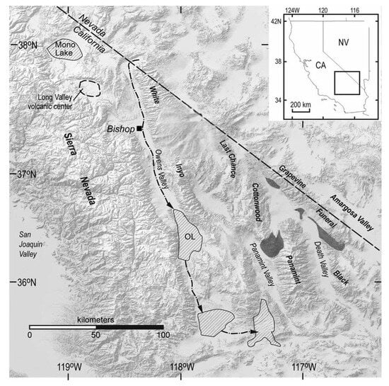
Figure 1.
Adapted from Pliocene–Pleistocene hydrology and pluvial lake, western Great Basin, Inyo County, California (Knott et al. 2023) CC BY-SA 4.0.
Intersections of geology, oral traditions, and material culture appear across archaeological, anthropological, and geological scholarship (Dundes 1968, p. 3; Wilke 1978; Medicine and Jacobs 2001, p. 71; McMillan and Hutchinson 2002; Laylander 2004).
Insights about relationships between geology and oral traditions hold the potential to profoundly impact how civilizations cognize relationships between humans and geological events (Hugmeyer 2014). Increasingly sophisticated analyses linking oral traditions with geology, geochemistry, and tectonics are emerging globally, particularly in the Mediterranean (Piccardi et al. 2008). Cross-disciplinary studies now correlate volcanic eruptions and seismic events, with research in the SW Pacific, Central America, North America, and the Aleutians yielding productive results (Cashman and Cronin 2008, p. 408). In Australia, where aboriginal cultures extend back more than 65,000 years, transdisciplinary teams have linked Tasmanian oral histories to the submergence of the Bassian Land Bridge in the Late Pleistocene, reaching its minimum declination 14,000 years ago (Hamacher et al. 2023).
This scholarship includes studies linking geology with Hawaii’s Pele legends, stories of the Oracle at Delphi, Mount Mazama accounts, British Isles creation legends, and Greek epics. Similarly, archaeological studies explore how oral traditions may encode dramatic geological changes from large-scale flooding. Echo-Hawk (2000, p. 278) presents archaeological evidence supporting possible Arikara migration to Wyoming and Colorado via the Great Basin around 9500 YBP due to environmental conditions. Cheyenne oral traditions similarly describe floods as mechanisms moving people throughout northeast Colorado (Leeming and Page 2000, p. 109).
2. Results
The author identified numerous correlations between multigenerational Numic oral traditions, ethnographic data, and material culture, including rock art, relating to large-scale geological events occurring from the Late Pleistocene/Early Holocene to Middle and Late Holocene, including the Late Dry Period, Medieval Climatic Anomaly, and Little Ice Age. Additionally, the author found that Numic oral traditions have continued to be passed along from generation to generation because of their intrinsic value as survival teachings. These teachings include narratives of resilience representing multigenerational memories of large-scale earth changes that are evidenced in geological and archaeological records. These multigenerational oral histories are represented in contemporary cultural knowledge systems, physical writings, and rock art. Such systems have the capacity to educate present and future generations. The interrelatedness of geological and cultural knowledge may increase the human capacity to understand collective histories and garner information that supports the survival of the community. These findings confirm that (1) people can remember for long durations of time, (2) ancient peoples recorded earth changes in oral traditions and the physical landscape, (3) the events discussed in oral traditions potentially leave geological and material traces through multiple forms including petroglyphs and pictographs, and (4) collective memories of life-threatening events leave memory residues that can last for thousands of years.
3. Discussion
Some of the most ancient ancestral teachings of the Nüümü include descriptions of humans navigating through and around major ice barriers and endeavoring to survive large-scale flooding episodes, cataclysmic earthquakes, fires, volcanic eruptions, and repeated, dramatic climate changes that resulted in changes in physical resources, including basic food sources. These multigenerational teachings include Numic memories depicting glacial landscapes in which ice is the starring role, covering large swaths of North America. During one period of glaciation, the ancestral Nüümü and Nuwu (Northern and Southern Paiute) report already being in the Great Basin and moving north to where they encounter a glacial ice sheet, somewhere along the Snake River, a 1674 km (1040 m) long river that extends through the states of Washington, Oregon, Idaho, and Wyoming (Kammerer 1990, p. 2). The Newe (Western Shoshone) teachings also describe dramatic events that include turbulent oceanic beginnings and the crossing into North America from another continent.
Multiple oral traditions also describe a time in which the Animals were People floating on Everlasting Water. Similarly, Numic ancestral teachings relay how Ocean Woman rubbed dead skin from the creases in her body to make land on the Immortal Waters, many times over (Laird 1976, p. 149). Other multigenerational Numic ancestral teachings describe periods when the known world was flooded, and the ancestors of today’s descended communities had to retreat to the tallest mountains within the Great Basin and California to find refuge until the waters receded. These spots likely became known as the creation mountains of later years, which potentially explains the current existence of multiple Numic places of creation.
In addition to major flooding events, the Nüümü have maintained and shared numerous multigenerational teachings of large-scale earthquakes and volcanic eruptions in western Nevada, Long Valley, and Owens Valley, California (See Figure 2). These earth changes have been relayed through the narrative devices of many mythical characters, including the cantankerous trickster character, Coyote, who is held responsible for many destructive earth events, including “Opening the Door” at the site of Malheur Cave in the state of Oregon. Other sample teachings describe the shrinking of the late Pleistocene Lake Lahontan, the description of lake water changing from fresh to saline, and the description of aquatic species moving from lake to lake with the progressive desiccation of the environment. How such narratives are evaluated within archeology is a matter of debate.

Figure 2.
Owens Valley, eastern California, and the eastern escarpment of the Sierra Nevada Mountains. Viewshed: southwest from Inyo Mountains near Harkless Flat. Tinemaha Reservoir is visible in the near distance (G. Thomas, Public Domain).
3.1. Current Debates
Throughout the twentieth century, oral traditions have had relatively minimal influence on ethnographic, ethnohistoric, and archaeological research in the Great Basin and surrounding regions. This is due in part to scholars being uncertain about “the degree of historical validity in orally conveyed traditions” (Dorson 1968, p. 3). Douglas Parks succinctly expresses the range of both historic and contemporary perspectives about oral traditions in anthropology, stating the following:
Anthropologists are by no means in agreement on the historical validity of events and locations occurring in myths. Some, like Robert Lowie, completely rejected all myths as accurate sources of any historical fact, while others, like Paul Radin, believed that historical events and past cultural patterns can be reconstructed from myths. Perhaps the majority, though, subscribe to Edward Sapir’s belief that authentic information can be found in myths when it is corroborated by other lines of evidence (e.g., archaeological, linguistic, or ethnographic).(Parks 1985, p. 57)
While folklorists and linguistic anthropologists have generally embraced oral traditions since the Victorian era (Dorson 1963; Frazer 1990), those in the social and natural sciences have developed a more mixed relationship with oral traditions, oral histories, and orality. Within the field of anthropology, Franz Boas, sometimes considered the Father of American Anthropology, maintained that “oral traditions constitute a kind of autobiography of the people” (Dundes 1968, p. 127). As such, his students dutifully solicited and recorded these narratives but typically relegated them to the status of “myths and legends.” Ferguson (2007, p. 378) notes changing attitudes about the anthropological use of southwestern Pueblo oral traditions as a source of historical information from the late nineteenth century through the Boasian period of American Anthropology. Whereas late nineteenth and early twentieth century scholars such as Fewkes (1900) and Mindeleff (1891) largely viewed Native American migration stories as history, this view was later replaced by anthropologists and ethnographers such as Curtis (1922, p. 16) who treated oral traditions as “legends” that were a mixture of fact and fiction. With the rise of Boasian anthropology, Ferguson notes that the historicity of oral traditions was largely rebutted and relegated to the realm of “myth.”
Working in the Great Basin, the Colorado Plateau, and California, a similar phenomenon occurred among Boas’ students, including Isabel Kelly, Alfred, and Edward Sapir, as well as the ensuing generation under the direction of professors Kroeber and Lowie, such as Julian Steward. As in other places throughout North America, throughout most of the twentieth century, “… oral traditions failed to receive the distinction accorded to other bodies of ethnographic knowledge.”
Today, there remains a divide about the use of oral traditions in anthropology (Mason 2006; McGhee 2008). However, increased awareness and interest in oral traditions among sociocultural anthropologists and archaeologists appears to correspond in part to the growing participation of Native Americans in historic and cultural preservation (Anyon et al. 2000, pp. 61–66; Ferguson et al. 2000, pp. 45–60; Vansina 1985, pp. 186–97).
3.2. Literature Review
Numic oral traditions were first recorded in written form by John Wesley Powell, a geologist, ethnographer, explorer, and the first director of the U.S. Bureau of Ethnology of the Smithsonian Institution. During two expeditions along the Colorado River and its tributaries, Powell began a systematic collection of Paiute oral traditions (Powell and Ingalls [1875] 1957).
Gathered alongside ethnographic and linguistic data from fieldwork conducted from 1868–1880, Powell was especially interested in a then-popular stage theory of cultural evolution. As a result of this theoretical orientation, Powell attended most closely to how Paiute and Shoshone narratives potentially matched this theoretical perspective (Powell 1881). Additionally, like many intellectuals of his day, Powell assumed that the oral stories of Native peoples should somehow match western written narratives in terms of length, style, and organization. Nevertheless, he managed to gather a substantial compendium of Numic oral traditions (Fowler and Fowler 1971; Powell 1873). Expressions of Nüümü (Northern Paiute), Nuwu (Southern Paiute), and Newe (Western Shoshone) orality, and different versions of particular oral traditions, also are evidenced in diverse writings (e.g., Fowler et al. 1970; Heizer and Hester 1972; Hopkins 1883; Intertribal Council of Nevada 1976; Laird 1976; St. Clair and Lowie 1909; Lowie 1924b; Martineau 1992; Mooney 1896; Palmer 1946; Sapir 1910; Steward 1933).
With the introduction of oral traditions as a recognized line of evidence in NAGPRA cultural affiliation studies (Echo-Hawk 2000, p. 267), an enhanced understanding of the diverse forms of orality began to emerge. An additional story form is the traditional ecological knowledge (TEK) narrative that encodes some of the earliest forms of scientific observation among diverse Indigenous communities (Berkes et al. 1995; Cajete 2000; Posey 1999; Sadler and Boothroyd 1994). Berkes et al. (1995, p. 283) identified characteristics of TEK, including the following:
- Restricted geographical scale observations;
- Reliance on mainly qualitative (rather than quantitative) information;
- Lack of a built-in drive to accumulate more and more facts;
- Slower speed in the accumulation of facts;
- More reliance on trial-and-error, rather than on systematic experimentation;
- Limited scope for the verification of predictions;
- Lack of interest in general principles or theory-building.
Importantly, oral traditions potentially assume the form of survival narratives. These are stories that encrypt general or specific information designed to help communities successfully navigate unanticipated challenges in an arena of life that could conceivably compromise the short and/or long-term welfare of the group. As such, natural disaster narratives are a form of survival narratives that involve both hazard assessment and mitigation processes (Masse et al. 2007, p. 16). Efforts to assess and mitigate damage are evidenced as the basis of both volcanic and earthquake oral traditions in the ancient Mediterranean and Middle East (Masse et al. 2007, p. 17).
3.3. Previous Research
Diverse examples of multigenerational oral traditions recording major geological events are found worldwide and throughout North America. In ancient Greece, the convergence of archaeology, oral traditions, and geology resulted in the identification of the Deluge of Deacalion and the lost island of Atlantis relating to the violent eruption of the volcano on the island of Santorini and an associated severely damaging tsunami (Bluestone 2010, p. 35). Similarly, University of Arizona archaeologists employed archaeological methods and research of oral traditions to positively identify the Grecian hometown of Zeus (Romano and Voyatzis 2021), Zedeño et al. (2021) explored the oral traditions and paleoarchaeology of the peopling of the Northwest Plains, and Cashman and Cronin (2008, p. 32) identified eruptions in the SW Pacific, Hawaii, Central America, North America, and the Aleutians identified in oral traditions.
In North America, among the Klamath Tribes of Oregon, one ancestral teaching centers on a fight between two chiefs. While not all archaeologists are acquainted with this multigenerational oral history, many are familiar with the eruption of Mt. Mazama, dated to 7700 years, based on the dendrochronology studies, or 6845 ± 50 years ago via radiocarbon dating. Identification of sandals in the ash layer by Luther Cressman catalyzed the opportunity to further substantiate convergences among geological data, material culture, and oral traditions (Cressman and Baker 1942). Now used as a standard metric in identifying the relative chronologies of archaeological sites with the Mt. Mazama ash layer, this date demonstrates a fruitful convergence of knowledge conveyed through ancestral oral histories, geology, and archaeology (Vitaliano 1973, p. 3). Today, Crater Lake is located within the caldera of this eruption (Figure 3).
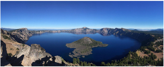
Figure 3.
Crater Lake from Watchman Lookout Station. CC BY-SA 4.0.
The merging of oral traditions and archaeological data are also evidenced in the changing lacustral intervals of Lake Cahilla in the Salton Basin over the last 2000 years. Cahuilla and Kumeyaay cultural representatives from the historic period learned of the existence of a large lake in the Salton Basin that did not exist in their own lifetimes (Laylander 2004; Wilke 1978). Wilke studied the paleoenvironmental, geological, archaeological, and historical information about cultural adaptations and identified three distinctive lacustral intervals in the last 2000 years, (1) 1000 BC-AD 600, (2) AD 900–1250, and (3) AD 1300 to 1500, after which the recession of the lake began (Wilke 1978, pp. 35–36) (Figure 4). Such findings are consistent with geomythological research worldwide.
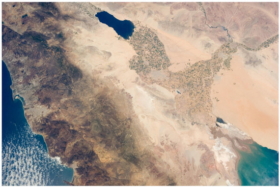
Figure 4.
Lake Cahuilla, NASA. Photographed by an Expedition 36 crew member on the International Space Station. Public Domain.
Each of these examples demonstrates interdisciplinary studies that include the critical analysis of multigenerational oral histories to constructively expand the type and range of research questions that may be asked in relation to archaeology and geology.
3.4. Theoretical Approaches
Recognizing the limitations inherent to established archaeological methods, some archaeologists have progressively warmed to the idea of using oral traditions in relation to archaeological inquiries. Even with the acquisition of substantial archaeological databases, it is understood that many aspects of culture remain elusive and may never be clearly and fully understood solely through the lens of materiality. Archaeology can learn much by using ancestral oral histories as working hypotheses. In addition to a growing appreciation of oral traditions as living processes, archaeologists and heritage managers see the potential of ancestral teachings as “repositories of cultural, historical, philosophical, and ecological knowledge” (Dundes 1968, p. 3; Medicine and Jacobs 2001, p. 71). Likewise, there is growing body of knowledge that explores the potential interdigitation of place, memory, and materiality (Casey [1987, 2000] 2009; Jones 2007; Mills and Walker 2008; Snead 2008; Van Dyke 2019, [2008] 2016; Van Dyke and Alcock 2003). Place-based narratives provide avenues to cultural teachings about the past, present, and future (Cruickshank 1991, p. 18; Damm 2005, p. 76; Tonkin 1995), and oral narratives provide yet another body of evidence for studies of memory and materiality that promise to challenge and invigorate archaeological methods and theories (Stilltoe 1998, p. 223).
Some archaeologists have shifted from site to landscape approaches, from static to dynamic modelling, and from singular ethnic to multiethnic analyses. In the process, oral traditions have become increasingly relevant in the formation of research queries. In some cases, the content of the oral traditions and scientific methods and theories clearly overlap. Cruickshank (1991, pp. 67–93) has found a productive convergence of orality and science in her work among the Indigenous Yukon of the Yukon Territory. Similarly, Bruchac (2005, pp. 56–80) demonstrates strong correlations between Algonkian Indigenous teachings and the landscape. Likewise, Echo-Hawk (2000, pp. 274–84) examines ancient oral traditions of the Caddoan of the Great Plains in relation to archaeological studies of migration themes.
Cultural studies of diverse ways of knowing have flourished over the past two decades. Studying North American Indigenous knowledge systems, Cajete writes, “Over the millennia Native people observed and experimented to understand how the world worked and to apply what was learned” (Cajete 2000, p. 44). Martin (2013) explores Native knowledge and its relevance for archaeological research. Martin records how diverse Native scientists have studied the processes through which Indigenous peoples have acquired and transmitted Native knowledge through time. Martin describes the process of observation, encryption, and knowledge sharing among North American Indigenous communities. First, Martin notes that people encrypt information into objects. They systematically use such encryptions to make connections and mobilize local knowledge (Martin 2013, p. 77). Second, Native communities generate knowledge as well as a vetting process. A cadre of knowledge specialists both guide and guard the knowledge transmission process (Martin 2013, p. 77). Third, after observing knowledge, Indigenous populations encrypted this information as signs and formulas that are translated into multiple forms of materiality, including petroglyphs and pictographs. Cajete writes, “Signs and formulas of thought appear in many forms, records in stone, clay, birch bark, hides, structures, and hundreds of other forms. These representations record key thoughts, understandings, and stories important to remembering key aspects of Native science” (Cajete 2000, p. 70).
When evaluating representations from the recent or ancient past, Lowenthal cautions that memories are always “eclectic, selective reconstructions” (Lowenthal 1985, p. 210). Similarly, Van Dyke and Alcock (2003, p. 3) remind us that “People remember or forget the past according to the needs of the present, and social memory is an active and ongoing process”. Notably, how social memory is constructed is a layered process that involves the positionality of the person engaging a remembered past, whose relationship to these social memories may range from immediate and direct experience to temporarily distant and indirect.
Likewise, it is important to consider that memories are always co-constructed events in which human and nonhuman actants (sensu Latour 2005) in the present potentially shape the research process, if by no other means than through the selection of research questions and the use of diverse bodies of data to explore those questions. Given the situatedness of all knowledge, all data analyses must ultimately be qualified in relationship to potential expressions of knowledge and power in the present. At the same time, it is equally important to consider the very real possibility that Numic populations have actively, intentionally, and cogently encoded some of the most ancient geological, archaeological, and sociocultural knowledge of California, the Great Basin, and the Colorado Plateau. To understand these relationships, we need look no further than the ancient oral traditions, cultural landscapes corresponding to distinctive geological features of the landscape, pictographs and petroglyphs, and associated ritual systems.
3.5. Geomythology
A particularly fruitful exploration of memory and orality has emerged through the work of geologist D.B. Vitaliano, the founder of geomythology. This interdisciplinary discipline allows abundant cross-pollination from multiple areas of study, including geology, mythology, folklore, and archaeology. Begun in 1973, this field is premised on the idea that the remote stories of our ancestors can tell us a lot about the geological history of our shared home, planet earth. Such narratives commonly include stories of earth destruction and regeneration. Geomythology denotes a study of natural processes and events that have been described through the collectively shared thoughts and memories of communities through time. Typically, two kinds of geological folklore are recognized. First, there are stories that are constructed by a community to explain unique geological phenomena that were not witnessed by the community. Such stories may explain and codify physiographic features or natural processes of which there is no direct knowledge. Secondly, there are geological stories that represent eyewitness accounts of geological events or processes, such as natural catastrophes (Piccardi and Masse 2007, p. vii; Vitaliano 1973).
Mayor (2007, p. 248) details nuanced oral traditions among the Pit River or Achumawi, the Chumash, and the Nissenan that describe and mark the location of ancient fossil traces, which ensuing generations replicated in rock art. Left in the volcanic flows that hardened into the present-day lava beds, these rare footprints preserved traces of prehistoric animals and humans. In 1908, Istet Woiche, an Achumawi elder who was born around 1840, relayed the teaching of Ja-mul dok-im-choi, “Coyote-man’s Track.” He explained that Ja-mul dok-im-choi left its mark in stone when the earth was young. Similarly, the Southern Nissenan people, and the Chumash people of California, have ancestral teachings of Sky Coyote leaving paw prints and Sky Lizard leaving five-digit impressions in a large white rock in primeval times before humans (Mayor 2007, p. 248). Mayor notes that Coyote-man’s Track may be a natural foot-shaped depression or a carving completed by an Achumawi medicine person to replicate a genuine fossil footprint seen in the Achumawi original homeland, where dinosaur tracks are common.
3.6. Research Gaps
While Numic communities have continued to pass oral traditions from generation to generation, and anthropologists have recorded oral traditions since the beginning of the discipline, there have been canonical understandings that have impeded the development of integrative modelling techniques that would facilitate processual embodied and diachronic understandings of oral traditions in relation to materiality. Whilst early Boasian anthropology was characterized by a four-field approach, few today would lay claim to such an expansive interdisciplinary modus of knowledge acquisition and production. With the shift of archaeology, cultural anthropology, biological anthropology, and linguistics toward increased specialization, small-scale and mid-level methods and theory have flourished. Despite this historic trajectory, a move toward more integrative theoretical and methodological approaches has been encouraged since the passage of NAGPRA in 1990. The current article is in keeping with this effort toward more holistic efforts to compare, contrast, and distill knowledge represented in oral traditions and materiality expressed through rock art, ethnography, geology, and paleohydrology.
3.7. Setting the Stage
Approximately 13,000 years ago, the large Pleistocene lake Lake Lahontan reached its most recent Sehoo Highstand (Adams and Wesnousky 1999, pp. 357–58), covering much of present-day Nevada, northeast California, and southern Oregon. Its surface area extended over 22,000 km2 (8500 square miles) with depths ranging from 270 m (900 feet) at Pyramid Lake to 150 m (500 feet) in the Black Rock Desert. By ~10,600 BC, Lake Lahontan dropped nearly 107 m (350 feet) (Mehringer 1986, p. 33). A stratigraphic analysis of succession at Searles Lake, located south of Owens Lake and Owens River, with drainage as far north as Mono Lake, shows a Wisconsin period of high-water levels followed by a period of smaller lakes correlated with the proceeding interstadial (G. I. Smith 1979; Smith and Street-Perrott 1983) (in Mehringer 1986, p. 34).
With the overflow of pluvial Lake Russell, a larger version of present-day Mono Lake, walls of water moved through the Adobe Valley to the Owens River, China Lake, and Searless Lake. These, in turn, overflowed into Panamint Valley and finally Death Valley (Mehringer 1986, p. 33).
George Laird, an esteemed Chemehuevi elder and keeper of the sacred songs, indicates that knowledge of these ancient events has been passed down to contemporary Numic people in the form of myths, songs, and language (Laird 1976, p. 7). These stories emerge from, and are part of, the Mythic Country, also known as the Sacred Land, “the place where stories start and end” (Laird 1976, p. 147). These emplaced narratives extend up to “the mysterious North,” to a time beyond known civilizations and “before the World was”, west to the sea, and south to the low deserts (Laird 1976, p. 147).
According to Numic oral traditions, after making the earth, Ocean Woman, with the assistance of the other Immortals, including the ever-mischievous Coyote (Laird 1976, p. 149), peopled her body with the people who are today known as the Paiutes and Shoshone. These people’s heroic journey begins in Ocean Woman’s proletaneous womb that fills to the point of bursting, an inquisitive Coyote, who against his better judgement, opens a sack, basket, net, or water jug, akin to Pandora’s box, to see who, or what, is inside (Figure 5).
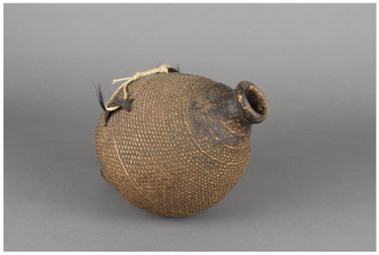
Figure 5.
Shoshone artist or Paiute artist; Water Jug Basket, ca. 1800, willow rod foundation; twill, split willow, and pine pitch, 13 7/8 in × 9 1/4 in diam.; gift of Mrs. Ferdinand C. Smith and Mr. L. Hawley Hoffman. Portland Art Museum, Portland, Oregon, 43.1.81.
A. M. Smith (1940) recognized that Numic storytellers link ethnogenesis accounts to specific localities, including several predominant mountains and valleys. Similarly, Sutton (1993) mentions the multiple origin mountains identified in Steward’s (1936) account, Myths of the Owens Valley Paiute. These include the following:
Black Mountain (in the White Mountains, on the east side of the valley) (Steward 1936, p. 364), Round Valley (just north of Owens Valley) (Steward 1936, p. 365), and Long Valley (just north of Long Valley) (Steward 1936, p. 366) … “All the Indian tribes” (Steward 1936, p. 366) were thus created, but the Miwok, Shoshoni, and Modoc were mentioned by name. There is no indication of any movement of Shoshoni groups to different places.(Sutton 1993, p. 114)
Places associated with the mythical Coyote tend to be landforms with low elevations, such as valleys or caves, for example, Coyote Valley in Owens Valley, Round Valley and Long Valley, and Coyote’s Jar in Pahranagat Valley (Stoffle et al. 2009, p. 34) and Coyote’s Hole, officially named Devil’s Hole, in Ash Meadows. Notably, in Numic oral traditions, Coyote is the change agent. His job in all the Paiute and Shoshone ethnogenesis tales is to carry a massive water jug or basket, whose contents he cannot contain. It is quite probable that the valleys named in Coyote’s honor memorialize the places through which floodwaters resulted from transgressions of late Pleistocene inland seas, lakes, and rivers. The presence of rock etchings of Ocean Woman’s net in Pahranagat Valley, and a locality named Coyote’s Jar, reinforces the idea of Coyote’s dramatic watery delivery of his children onto the “plains” of their aboriginal homelands (Figure 6).
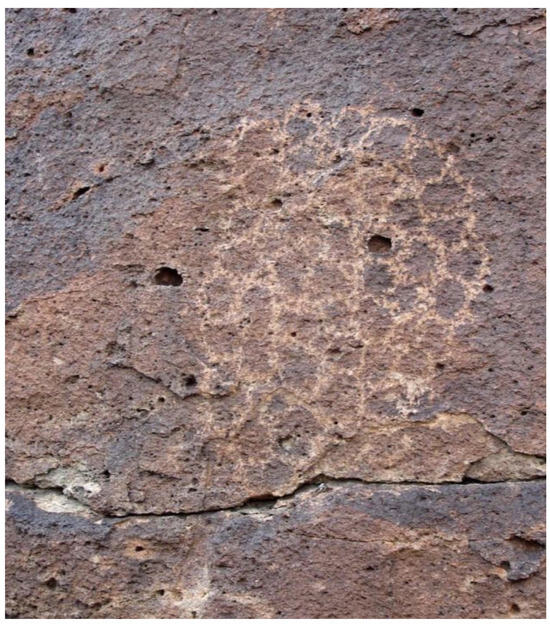
Figure 6.
Ocean Woman’s Net, Pahranagat, NV (BARA, University of Arizona).
In many versions … Coyote pursues the daughter, as in a hunt, and finally catches up to her at the edge of a large body of water. In other versions, the home of the women is on an island surrounded by water or across a body of water from Coyote (M2, M4, M7, M9, M11, M12, M13, M14, Ml5). Water in opposition to Coyote (a land animal) is also shown in some myth variants by his need to change into a water skate or water skipper in order to cross the water.(Myers 1997, p. 36)
3.8. Ancient Floods on the Pacific Rim
Through the critical analysis of geological phenomena, it is possible to isolate events that may correlate with the water incursions described in these ancient Numic water teachings. Three geological phenomena are possible candidates: (1) oceanic tsunamis, (2) super-floods, and (3) transgressions of ancient lakes such as Lake Russel and Owens Lake in central California.
At Bradley Lake in southern Oregon, Kelsey et al. (2005) conducted a coastal study that presents a continuous record of earthquakes and tsunamis over the last 7000 years. “This Tsunami history of an Oregon coastal lake reveals a 4600 yr. record of great earthquakes on the Cascadia subduction zone” (Kelsey et al. 2005, p. 1009). Using 14 piston uncompacted core samples (50 mm diameter) and 13 vibracores (70 mm diameter), they identified 13 marine incursions and 4 disturbances without marine incursions.
Kelsey et al. (2005, p. 1009) indicate that each marine incursion lasted at least 10 min, with ocean levels “at least 5–8 m above sea level” (ibid.). Earthquakes accompanied both marine and non-marine incursions. “An offshore record of seismically triggered turbidites at the heads of Cascadia submarine canyons suggests that great earthquakes recur at intervals of ~600 yr, with 13 in the last 7700 yr (Adams 1990; Goldfinger et al. 2003)” (ibid.).
While the size of the tsunamis varied, an example of scale is provided in the remarkably detailed geological and historic records that exist for an A.D. 1700 earthquake along the Cascadian subduction zone.
This earthquake was probably a Mw 9, based on the size of the associated tsunami on the Japanese coast as documented in written records. An earthquake of such magnitude probably ruptured the entire ~1200 km length of the subduction zone.(Kelsey et al. 2005, p. 1009)
The range of tsunami dates extends between 4600 and 2800 cal yr. BP, which documented average frequencies through time, beginning with the following:
~3–4 every 1000 yr. Then, starting ~2800 cal. yr. B.P., there was a 930–1260 yr. interval with no tsunamis. That gap was followed by a ~1000 yr. period with 4 tsunamis … Local tsunamis entered Bradley Lake an average of every 390 yr., whereas the portion of the Cascadia plate boundary that underlies Bradley Lake ruptured in a great earthquake less frequently, about once every 500 yr. Therefore, the entire length of the subduction zone does not rupture in every earthquake.(Kelsey et al. 2005, p. 1009)
Tsunamis generated from the Cascadia subduction zone would have had a significant impact on the aboriginal peoples living in the present-day states of Oregon and northern California. This would potentially include ancestors of federally recognized tribes with substantial Northern Paiute populations such as the Burns Paiute Tribe (OR), the Confederated Tribes of Warm Springs (OR), Fort Bidwell Indian Community (CA), Fort McDermitt Paiute and Shoshone Tribes (NV, OR), Klamath Tribes, including the Yahooskin Band of Paiute (OR), Cedarville Rancheria Northern Paiute Tribe (CA), and Susanville Indian Rancheria (CA). A 5–8 m sea level rise would require people in low elevations to relocate temporarily or permanently outside of the flood plains.
In central and southern California and the western Great Basin, it is less probable that the tsunamis associated with the Cascadia subduction zone would have had an appreciable impact on the environment and people. Nevertheless, there are numerous flood narratives recorded among the Northern Paiute, Western Shoshone, and Southern Paiute of these areas, as well as the Colorado Plateau.
USGS hydrologist Michael Dettinger and paleoclimatologist B. Lynn Ingram (UC Berkeley) and others are currently studying another mechanism for large-scale flooding that could pertain to these areas. Described as “super-floods,” or “atmospheric rivers,” these events occur on average once every 200 years (Langlois 2017). A reporter for the historic newspaper, Nevada City Democrat, described the Western Shoshone response to an anticipated super-flood on 11 January 1862.
We are informed that the Indians living in the vicinity of Marysville [ghost town in Nye County, Nevada on the present-day Yomba Shoshone Reservation] left their abodes a week or more ago for the foothills predicting an unprecedented overflow. They told the whites that the water would be higher than it has been for thirty years and pointed high up on the trees and houses where it would come. The valley Indians have traditions that the water occasionally rises 15 or 20 feet higher than it has been at any time since the country was settled by whites, and as they live in the open air and watch closely all the weather indications, it is not improbable that they may have better means than the whites of anticipating a great storm.
Ingram writes that the state of California declared bankruptcy due to the magnitude of damage that occurred in the wake of this massive flood (Figure 7). “Thousands of people died, towns were submerged, and the state’s economy was devastated, yet it was nowhere near the worst: One flood in the 1600s was at least twice as big.” (Ingram 2013). Despite the enormity of this storm, the Western Shoshone were prepared. Their response to these floods indicates (1) prior experience with flooding events in the Smoky Valley of central Nevada; (2) a practice of monitoring flood levels; (3) a strategy to minimize damage by moving to higher elevations as previously mentioned in diverse ethnogenesis accounts; and (4) a cultural practice of sharing information about potentially hazardous events induced by weather and climatic changes.
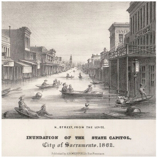
Figure 7.
Inundation of the State Capitol. City of Sacramento, 1862. Public Domain.
Schimmelmann et al. (2003) also identify paleoclimatic and archaeological evidence of recurrent ~200-year floods and drought cycles linking California, Mesoamerica, and South America over the past 2000 years. Using varve Holocene sediment cores from the Santa Monica Basin of California, they documented six flood layers dated to AD 1605 ± 5 yr, 1418 ± 10 yr, 1029 + 20 yr, 603 ± 35 yr, 440 ± 40 yr, and 212 ± 50 yr. (Schimmelmann et al. 2003, p. 765).
Schimmelmann et al. (2003) found that correlations of flood episodes and archaeological and paleobotanical evidence in South American and Caribbean cultural traditions “firmly implicates manifestations of changing climates as destabilizing factors for many precolumbian cultural discontinuities” (Schimmelmann et al. 2003, p. 775). By contrast, they did not find a similar pattern of periodicity in the southwestern United States.
Archaeological chronologies of cultural transitions in the southwestern USA (McBrinn and Cordell 1997) do not reflect a -200-yr periodicity, or any significant correlation with flood deposits in the SBB”.(Schimmelmann et al. 2003, p. 774)
One possibility is that the former study overlooked larger flooding patterns, such as those identified on the Colorado Plateau (Baker 2006, p. 165).
For the past several decades, paleohydrologist Victor Baker of the University of Arizona has been using techniques similar to [Koji] Minoura’s to study the flood history of the Colorado Plateau. Like Minoura [who discovered three major earthquakes linked to tsunamis over three thousand years], he’s found that floods much larger than any in recorded history are routine occurrences.(Langlois 2017)
In the previously mentioned historic example of Western Shoshone cultural adaptations to recurrent flooding, including cyclical pluvial flooding, it appears that an even narrower timeframe, as indicated in the thirty-year reference, may have been occurring in central Nevada in the late nineteenth century than in Central and South America. Based on currently held information, it is unclear whether this 30-year cycle pertains to Numa, Nuwuvi, and Newe peoples living in other parts of the Great Basin and California.
A third geological correlate to Numic ethnogenesis water teachings is the major transgressions of ancient Pleistocene lakes. In central California, Orme and Orme (2008), for example, identify two major transgressions of Owens Lake during the late Pleistocene. They describe Owens Lake as follows:
A fluctuating, increasingly saline, terminal lake [that] survived into the late Holocene until upstream water diversions to the Los Angeles Aqueduct began in 1913. Shoreline fragments and beach stratigraphy indicate that the lake reached its highest late Pleistocene level around 23.5 ka, during the Last Glacial Maximum, when it was fed by meltwaters from Sierra Nevada glaciers and spilled southward to Searles Lake and beyond. The lake then fell to relatively low levels after 16.5 ka before experiencing terminal Pleistocene oscillations related to hydroclimatic forcing, which involved changing regional precipitation regimes rather than major inputs from Sierra Nevada glaciers. Two major transgressions occurred. The first culminated around 14.3 ka and was probably related to a cooler, wetter regional climate. The second culminated around 12.8 ka and was linked to the earlier wetter phase of the Younger Dryas cold event. However, the high late Pleistocene shoreline is deformed, and the highest beach ranges in elevation from 1140 m to 1167 m above sea level. If the terminal Pleistocene lake overflowed, as suggested here, then its outlet has also been raised since 12.8 ka.
Numic ethnogenesis accounts offer potential clues about the patterns and extent of the floodwaters that breached a major body of water, translated in some ethnogenesis accounts as an “ocean” and in the footnotes of Julian Steward as a “large water”, i.e., a “lake” (Steward 1943, p. 262). Could this be one of the two major transgressions of Owens Lake in 14.3 ka or 12.8 ka? According to Northern Paiute, Western Shoshone, and Southern Paiute water oral traditions, Coyote’s water jug passed through many places in the Mojave Desert and Great Basin, including Owens Valley, Owens River, Saline Valley, Death Valley, Tin Mountain (Charleston Peak), Smoky Valley, Moapa, and Skull Valley (Steward 1943).
So challenging did the first Euro-American colonists find one of these regions that they renamed the Newe landscape “Death Valley,” a name that has stuck for over 150 years. Describing the western edge of the Great Basin, Irwin writes,
It is a turbulent land; occasional torrential downpours send walls of water plunging down canyons scouring everything … the alluvial fans and depressions where they deposit mud and boulders; winds abrade granite boulders and outcroppings; winter winds from the north cut like obsidian blades; and oven-like summers drain the resolve from the most determined explorers, reddish cinder cones and dark malpais (rough lava) outcroppings and walls are silent testimonies to profound geologic event from the past.(Irwin 1980, p. vii)
4. Ethnogenesis
In Life in the Land: The Story of the Kaibab Deer, Prendergast dramatically frames a class of narratives that include graphic sexual encounters between Coyote and other Immortal Ones as a “prehistoric barrier to human fertility” (Prendergast 2005, p. 13). These oral histories describe the tenuous prospect of life’s continuation in the wake of natural disasters including volcanism and flooding (see, for example, Steward 1936, pp. 365–68; Laird 1976, pp. 20–21, 149–52; Steward 1943, pp. 262–63; Kelly 1938, pp. 372–75; Smith and Hayes 1993, pp. 89–90, 150–51, 156–58; Lowie 1924b, pp. 103–4, 209–12). Relayed through oration for centuries before being written, these descriptions juxtapose the unlikelihood of life emerging from the barrenness of a landscape in transition (Powell in Fowler and Fowler 1971, p. 73). Julian Steward records a Death Valley version of this oral tradition (Steward 1943, pp. 262–63). Discussing seven variants of this narrative of Creation, Myers notes,
At first, the earth is covered with water and so the women play a dominant role. When Coyote breaks the vagina dentata, the roles shift and it is Coyote and land that are dominant.(Myers 1997, p. 38)
This reading is consistent with Lowie’s reading of the transition from water-based to pedestrian foraging adaptations. Lowie writes, “Rabbits, antelope, and other game of that sort belonged to men; ducks, swans, and geese belonged to the woman with vaginal teeth” (Lowie 1924b, p. 229). These precarious geological rendezvous involving Coyote, a woman (in some versions, Louse), and her mother are accompanied by the powerful release of earthly amniotic fluids on a scale memorable enough to be concretized in the most stable of multigenerational teachings and the remarkable symbolic rebirth of the Indigenous nations of the western quadrants of North America.
The actions of the women, and their reactions to Coyote, provide for the events leading up to the removal of the vagina dentata. In most versions of this oral history, “Coyote removes the vagina dentata of both the mother and daughter … In some variants … Coyote impregnates not only the girl, but her mother as well” (Myers 1997, p. 38). These narratives provide important vantage points for understanding some of the earliest collective memories of earth changes, including among the Timbisha Shoshone of Death Valley.
The Numic presence in Death Valley is well established in archaeological, historic, ethnohistoric, and ethnographic accounts and scholarship. C. S. Fowler (2008) provides an excellent review of nineteenth and twentieth-century accounts of the Timbisha Shoshone (see, for example, Irwin 1980; Steward 1938, 1941; Driver 1937; Bean 1992; Dayley 1989; Thomas et al. 1986). In addition to historic, ethnohistoric, and ethnographic scholarship, archaeological and geological research provides frameworks for interpreting data that extends back to the late Pleistocene.
Beginning in the late nineteenth century, the deeply established ethnological and archaeological footprint of the Newe began to attract the attention of non-natives as well. In 1849, Manly described seeing petroglyphs in the eastern Panamints, as well as trails, campfires, dwellings, and a cave that had the appearance of being continuously used by Indians (Manly 1928, p. 138). In 1883, Hubert Bancroft described the Western Shoshone of Death Valley as “lovers of their country. They were lovers not of fair hills and fertile valleys, but of inhospitable mountains and barren plains” (C. S. Fowler 2008). Over the next fifty years, other early Euro-American explorers would repeatedly find inscriptions upon rock panels demonstrating an established and longstanding aboriginal presence in Death Valley (Hanks 1883, p. 34; Miller 1919; Mallery 1893, pp. 60–61) (see Wallace 1977). From 1952 to 1962, Death Valley archaeological research expanded. Cumulatively, this cooperative agreement resulted in the identification and recordation of 1400 prehistoric sites, including open campsites, caves, and rock shelters, quarries and workshops, and various rock constructions (mounds, circles, hunting blinds, alignments, and petroglyphs and pictographs). Secondly, Wallace indicates that the archaeological findings documented a span of human experience within Death Valley “covering 10,000 years or so,” which have been designated as Death Valley I, II, III, and IV (Wallace 1958, pp. 10–15; A. Hunt 1960, p. 12; C. B. Hunt 1975, pp. 157–73) (see Wallace 1977).
The Numic teachings of Tem-pin-tta-Wo’sah, Ubehebe Crater, Little Hebe Crater, Ubehebe Peak, and Coyote’s Hole foreground the unique geological landscape of Death Valley, Ash Meadows, and the centrality of vagina dentatum narratives to the Numic Peoples’ ethnogenesis and ritual performances.
In Death Valley, California, the folds of Pia Sokopia’s skin still reveal both recent and ancient earth births. In these environs, the Newe gave powerful descriptions of transformations that entail seismic activity, volcanism, and flooding in association with Ubehebe, the “big basket in the rock” (Sharp and Glazner 1997, p. 153), and her daughter, Louse.
C. B. Hunt (1975, pp. 14–15) paints a picture of Death Valley as a land in transition. He describes the filling of the Pleistocene Death Valley lakes through “the south by way of the Mojave River and Soda Lake. The distribution of fishes in desert springs in the region suggests the same thing” (C. B. Hunt 1975, pp. 14–15). Along these shorelines is evidence of human occupation in the late Pleistocene. Again, in the Middle Holocene, a shallow lake or pond flooded the floor of Death Valley, reaching “a maximum depth of 30 feet … This shallow lake has been dated archaeologically in the period from 3000 B.C. to A.D. 1” (C. B. Hunt 1975, pp. 14–15). Finally, in February of 1969, another lake was formed in Death Valley (ibid.), caused by melting snow in the Panamint Range and sporadic rains over several days.
Salt Creek and the Amargosa River discharged all the way to Badwater Basin. About 80 square miles of the salt pan was flooded; in the lowest part, between Badwater and Eagle Borax, the water was 2 to 3 feet deep. If the average depth over the 80 square miles was 1 foot, the volume of water was about 50,000-acre feet … [By contrast], the Holocene lake was ten times as deep as the 1969 lake and covered at least four times as much surface; the volume of water therefore must have been about forty times as large.(ibid.)
Newe place names such as Tem-pin-tta-Wo’sah (Coyote’s Basket) and Coyote’s Hole (currently designated as Devil’s Hole) provide etymological clues into aspects of unique geological features and distant geological events metaphorically described in living oral traditions (C. B. Hunt 1975, p. 33).
A key figure among the Immortals, Coyote (Canis latrans), has always been both a source of reverence and humor among the Nüümü. The coyote was the most prominent figure in California. In the trickster myths of the Shoshoni and the Paiutes, Coyote is represented as the primeval originator, instigator, troublemaker, and clown. Coyote was an object of both reverence and jesting (Irwin 1980, p. 42). Coyote is revered among other Indigenous peoples as well, who often view him as “the creator and progenitor of all things” (Powers 1976, pp. 147, 182). Due to Coyote’s special status, the coyote was not hunted or eaten until payment of bounties for pelts changed this practice (Irwin 1980, p. 26). Ritual specialists have been known to “receive drops of coyote blood as children, enabling them to be fleet-footed and to travel great distances” (Irwin 1980, p. 30), and images of Coyote are inscribed as petroglyphs upon boulders in Panamint Valley (Irwin 1980, p. 41), in the Storied Lands, where Coyote and the other Immortals are credited with creating the current geological and cultural landscapes of this region (Laird 1976, p. 147). Near Scotty’s Castle, a small lava outcrop is credited to an encounter between Coyote (esha pioere) and Stink Bug (ter pee see poon kee) (Irwin 1980, p. 50; Dayley 1989, p. 69). Stink Bug is also associated with seismic activity near Puerto Penasco in the Southwest of the United States. Coyote is also said to have eaten his brains at another local spot (Irwin 1980, p. 50; Dayley 1989, p. 69).
One version of the ethnogenesis teaching involving Coyote, a girl, and her mother that was previously relayed appears to mythologize not only multiple episodes of large-scale earth changes but also the literal and metaphorical spread the Nüümü from California through the Great Basin and Colorado Plateau (Lowie 1909, 1924b; Steward 1936, 1943). Two areas of interest in relation to the ancestral teachings are (1) the cyclical flooding and drying of the Death Valley lake beds and (2) volcanism in relation to Ubehebe Crater and her daughter. In addition to ancestral teachings alluding to geological changes, cultural tagging of geological markers gives another productive avenue for exploring potential convergences between and among archaeology, geology, and oral traditions.
Located in the Ash Meadows National Wildlife Refuge, a satellite unit of Death Valley National Park, “Devil’s Hole,” which is a misnomer for “Coyote’s Hole” (C. B. Hunt 1975, p. 33), is best known today as a habitat for Cyprinodon diabolis (Devil’s Hole pupfish), a fish species that established itself in this region ~10,000 years ago (NPS 2019). Coyote’s Hole is a massive limestone cavern opening into a seemingly bottomless geothermal pool that is responsive to earthquake and tsunami events as far away as Japan, Indonesia, and Chile (NPS 2019). Geologists have indicated that Coyote’s Hole/Devil’s Hole is connected to a complex series of drainage systems that today are responsive to seismic activities worldwide and, during the Pleistocene, linked much of the western quadrant of the USA. (Denny and Drewes 1965, p. L5).
Just as Coyote’s Hole is a unique physiographic feature of the landscape that is foundational to some core ancestral teachings, so too the nearby volcanic crater and mountain, Ubehebe Crater and Ubehebe Peak, respectively, are geological and cultural landmarks that figure prominently in the oral traditions of the Newe. Located on the northern edge of the Cottonwood Mountains, Ubehebe is the youngest as well as the largest of fourteen craters (Fierstein and Hildreth 2016), whereas “Little Hebe [is] in the middle spatially and temporally” (Fierstein and Hildreth 2016, p. 18). According to Timbisha elders, Ubehebe Crater is an origin spot (Figure 8).

Figure 8.
Ubehebe Crater, Tem-pin-tta-Wo’sah, Coyote’s Basket, Death Valley.
Ubehebe Crater references a proverbial “big basket in the rock” (Dayley 1989, pp. 322, 390; Sharp and Glazner 1997, p. 153) that Ocean Woman is said to have entrusted to Coyote, who in turn is credited with upsetting its contents, thus scattering some of the Ancient Ones throughout California, the Great Basin, and the Colorado Plateau. Crum provides a summary of these primary teachings in The Road on Which We Came (1994). He states,
Once placed on the land, two native women instructed the coyote to carry a large, pitched water-basket with him on his journey into the Basin area. Coyote was specifically told not to open the lid. Moved by irrepressible curiosity, he periodically opened the basket during his trip. The beings concealed inside jumped out here and there. The Newe believed this explains why they live over a large area. Today, family groups can be found in Death Valley, the Reese River Valley, Ruby Valley, the South Fork Valley, and numerous other places, primarily in Nevada.(Crum 1994, p. 1)
Ubehebe Crater sits next to her daughter, “Little Hebe Crater,” protagonists that reappear in the Peoples’ ethnogenesis teachings as a woman or louse and her mother. Both craters serve as dramatic memory anchors of volcanic explosions estimated to have reconfigured the landscape of Death Valley between 6000 and 10,000 years ago (Sharp and Glazner 1997, p. 155). Ubehebe Crater is a large volcanic crater that is 777′ deep [237 m] “below the highest point of its east rim” and roughly half a mile across (Sharp and Glazner 1997, p. 153). The name “Ubehebe” or “big basket” is sometimes used in reference to the crater as well as Ubehebe Peak, a mountaintop situated 24 miles southwest of the crater. The Timbisha Shoshone also named this dramatic landmark as “Tem-pin-tta-Wo’sah,” Coyote’s Basket, or tümpingwosa, “rock basket.” Dayley (1989, pp. 322, 390) deconstructs the term “Tumping wosa,” to mean “Tumpin” = “rock,” or “stone;” “Wosa” = Large conical carrying basket.
The term Ubehebe is also linked to the phrase hüüppi pitsi, meaning “old woman’s breast,” to suggest the remaking of the Death Valley and Ash Meadows at a geological scale (Bright 1998, p. 159). Contemporary Numic cultural representatives recalled how women used to squirt breast milk upon the volcanic rocks (Carroll et al. 2006, p. 21). Notably, geologists indicate that, at the floor of the Ubehebe Crater, is a playa lake that flooded at times (Eyles and Daurio 2015, pp. 236, 232), which may have been observed by the Numic speakers who lived in Death Valley, the Panamint Range, and Cottonwood Mountains.
Estimations of Ubehebe Crater’s last eruption range from 2 to 7000 years ago. Ubehebe was the “last and largest in a series of similar hydrovolcanic or phreatic eruptions” in the immediate area. This assessed range of dates and material cultural record suggest the possibility of culturally witnessed flooding, seismic activity, and volcanic eruptions experienced first at an embodied level and later codified in language and ritual (Vitaliano 2007), whereas descriptions of an emptied woman’s breast could be considered an explanatory narrative device used to rationalize a massive earth change or an extant landscape (Vitaliano 2007).
In addition to encoding multigenerational memories of geological events linguistically in place names and oral traditions, the Newe appear to have inscribed elements of these histories into the rocks themselves. A 1913 historic topo map of the Ballarat, NV, CA Quad, includes imagery of Owens Lake prior to its controversial drainage to support the growing water demands of Los Angeles. It also provides useful information for reconstructing spatial and probable behavioral relationships of Numic peoples to the physical and cultural landscapes following two major transgressions of the late Pleistocene Owens Lake. The eastern edge of the Owens Lake Basin is approximately 19.3 km (12 miles) from Saline Valley as the crow flies. Saline Valley is renowned for borax and salt deposits that prospectors began to extract for profit during the nineteenth century.
The Saline Valley cable tramway was constructed between 1910 and 1913 by the Saline Valley Salt Works to transport pure salt deposits from the salt lake in Saline Valley across the Inyo Mountains to Owens Valley. There it was milled and shipped via the Carson & Colorado narrow gauge railroad north to Nevada. Gondola cars carrying 800 pounds of salt, traversed the 13.5 [mile] series of tramways at a rate of 20 tons per hour over the Inyo Mountains. A total of 30,000 tons of high grade salt was carried over the tramway on and off through the early 1930s.(Owens Valley History 2025)
This historic map references two sets of “pictured rocks”: the first set of inscriptions is located at an elevation of 1433 m (4700 ft), and the second is located near sea level at the confluence of Marble and Cottonwood Canyons. Adam E. Treganza, from San Francisco State University, and Arnold R. Pilling, from University of California Archaeological Survey, first conducted reconnaissance at these sites in 1951 (Wallace 1977, pp. 251–52). Since this time, this region has become a hub for geological, archaeological, and historical inquiries.
According to C. B. Hunt (1975, p. 157), the first known inhabitants of Death Valley (Lake Mojave) appear to have arrived in the late Pleistocene. Death Valley began to dry up during the early Holocene and was then again wetter and milder ca. 2000 BC to AD 1 (C. B. Hunt 1975, p. 158). As in the Bonneville flood plain of southwestern Idaho, Indigenous populations appear to have inscribed petroglyphs in regions surrounding Death Valley to illustrate and commemorate the catastrophic flooding of Death Valley.
4.1. Petroglyphs as Embodied Geological Memory: Visual Narratives of Earth Changes
The Marble Canyon petroglyphs function as more than artistic representations—they constitute embodied geological memory that integrates natural rock features with cultural narratives of earth changes. These visual texts demonstrate sophisticated Indigenous knowledge systems that preserve both geological events and their cultural meanings across millennia. Petroglyphs in Marble Canyon include images of “Nariwiin apiwi, the Immortal Ones, Everlasting Ones … literally Self-Mythologizing Ones” (Laird 1976, p. 147). Animals, including Sheep, Coyote, and Louse, that figure importantly in the etiological oral tradition explain hydrological events via a pairing of Ocean Woman and her smaller daughter, Louse, and in other versions, water babies (Figure 9).
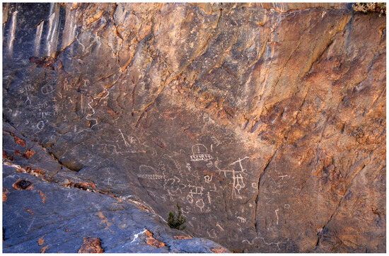
Figure 9.
Self-Mythologizing Ones, petroglyphs from Marble Canyon, Courtesy of Ron Gilbert.
4.2. Visual Encoding of Ethnogenesis Narratives
The petroglyphs translate complex oral traditions of ethnogenesis into durable visual forms through specific iconographic elements:
- Bighorn Sheep with Exaggerated Anatomy: The depicted sheep (Ovis canadensis), with a “long swollen neck”, encodes both biological knowledge (rutting behavior) and mythological function (the instrument of transformation), linking natural animal behavior to cosmological change (Myers 1997, p. 37; Whitley 1982, p. 263).
- Coyote as Water Carrier: Coyote’s (Canis latrans) presence connects the visual narrative to the flooding and water dispersal elements of multiple ethnogenesis accounts (Lowie 1924a; Sapir 1931; Steward 1936, 1943; Kelly 1938; Fowler and Fowler 1971), marking him both protagonist and geological agent. Both snake and zigzag motifs are alternately correlated to seismic activity and moving water (Hough 2007).
- Vagina Dentata: Semi-circles with a zigzag foundation, Ocean Woman and her daughter, Louse, the target of coyote’s advances (Whitley 1982, p. 263). (Figure 10 and Figure 11).
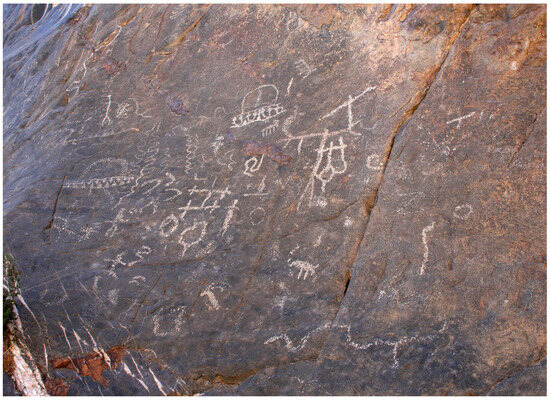 Figure 10. Geologically integrated petroglyphs of Bighorn Sheep, Coyote, and Mother and Daughter from Marble Canyon, Courtesy of Ron Gilbert.
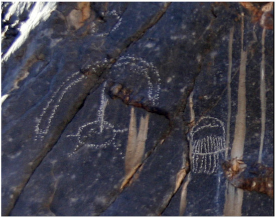 Figure 11. Vagina dentatum and Louse petroglyphs from Marble Canyon, Courtesy of Ron Gilbert.
 - Geological Integration: The positioning of key imagery relative to the natural crack in the panel surface suggests the artists understood these locations as places where mythological events literally occurred, making the petroglyphs site-specific commemorations rather than generic illustrations (Figure 8).
4.3. Citational Rock Art
The Marble Canyon petroglyphs exemplify what can be termed “citational rock art”—Indigenous visual narratives that incorporate natural geological features as integral narrative elements. The most striking example appears in the depiction of the protagonists (Coyote along with a rutting sheep) adjacent to a major natural crack in the bedrock surface. The vagina dentata are displayed in the petroglyph panel as well. This juxtaposition suggests the artists deliberately used the geological fissure as a co-created element of their visual story, potentially representing the following:
- The location where catastrophic floodwaters receded into the earth (Coyote’s Hole?);
- The metaphorical “opening” of the earth following the removal of the vagina dentata;
- A geological “scar” marking the transformation from the water-dominated previous world to the current terrestrial landscape.
4.4. Spatial Relationships and Cultural Geography
The strategic placement of petroglyph sites is potentially indicative of a sophisticated understanding of landscape relationships. The “pictured rocks” are situated in canyons that are marked by scarring from extreme flooding events that transpired in the traditional homelands of the Newe. The 19.3 km (12 miles) between Owens Lake and Saline Valley places the Marble Canyon petroglyphs within a cultural landscape that witnessed multiple episodes of lacustrine transgression and recession, suggesting these visual narratives served as geographical markers preserving knowledge of how water moved across this terrain during catastrophic flood events. This integration of geological observation, cultural memory, and artistic expression demonstrates how Indigenous knowledge systems preserved critical environmental information while embedding it within meaningful cultural frameworks that ensured intergenerational transmission of both practical and sacred knowledge.
5. Materials and Methods
The data for this analysis of multigenerational teachings represent 824 emplaced memory chains spanning from the Late Pleistocene/Early Holocene to the Middle and Late Holocene, including the Late Holocene Dry Period, Medieval Climatic Anomaly, and Little Ice Age. Each collective memory contributed to a broadening of witnessed and shared narratives of the peopling of the Great Basin and other distant events in which geological changes and climate shifts served as push/pull factors. The historical and social context proceeding the written record of ancestral oral histories, and the perceived strengths and weaknesses of these records, was examined (Ruuska, in press). In the process, the author compared information within each ancestral teaching to published data about potentially associated geological processes, the archaeological record, and traditional knowledge recorded in interviews, ethnographies, ethnologies, ethnohistories, and both primary and secondary histories. The findings of this study challenge assumptions about the nature, function, and duration of multigenerational memories as well as twentieth century theories of a singular late arrival of the Numic peoples into the Great Basin, indicating a likely scenario in which ancient peoples creating and disseminating the multigenerational oral traditions became the progenitors of those who are today known as the Indigenous Nüümü, Nuwu, and Newe peoples.
The analysis was conducted utilizing the GOAT! phenomenological method. This method provided a way to critically consider and compare the onto-epistemologies of Numic peoples, utilizing a wide range of data from (G)eology, (O)ral traditions, (A)rchaeology/Rock Art, and (T)raditional knowledge. To begin, phenomenological research typically follows core steps including (I) identifying the phenomena of study, (II) developing detailed descriptions of the phenomena, (III) bracketing personal assumptions and potential biases of the researcher and field of study, and (IV) collecting data. In the current study, the author critically considers ancestral teachings described in the archaeological and anthropological literature as myths and oral traditions. Next, the author considers how to study oral traditions in relation to materiality. Third, the author explores potential biases of the researcher and the field of anthropology that might affect the research, including being a non-Tribal member, being a female, being socialized in a society in which written languages are favored over orality, and growing up in a society that bifurcates subjective and objective knowledge. The next step entailed collecting detailed descriptions and conducting content analyses of these teachings. The teaching was studied and the following information recorded: (1) the article name or provenience of oral narratives [myth number, title], (2) citation [author, year: page], (3) narrative ethnic provenience [e.g., Shivwits, Southern Paiute; Shoshone], (4) geological, astronomical, faunal, or floral reference [e.g., Rock, Giant], (5) anthropomorphized nature reference, [e.g., Coyote, Stink Bug], (6) anthropomorphized nature reference [e.g., Coyote referenced as “Our Father”], (7) potential nature-based correlate [e.g., Flood, Ice], (8) absolute or relative dates [e.g., “In the time when Animals were People”], (9) location or place names [e.g., Tinemaha], (10) passage excerpts [e.g., “After the dance they passed going north, but before they got halfway, the pinenut people caused ice to cover the river so no one dared cross.”], (11) material correlates [e.g., rock art, petroglyphs of key archetypes such as Coyote, Louse, etc.], (12) ritual behaviors [e.g., dance], and (13) identifiable performance characteristics [e.g., elevations of physiographic features].
5.1. Documentation
The author’s interest in the role of geology in Numic cultural understandings of the sentient lands of the Great Basin and Colorado Plateau emerged in 2003–2007 with the analysis of ceremonial sites utilized in 1870 and 1890 Ghost Dances as well as 1999 and 2006 (Hittman 1999). In fieldwork conducted from 2003 to 2006, it became evident that Ghost Dance participants often returned to ceremonial places that had been utilized over the course of thousands of years. Ghost Dance participants from as far away as the Dakotas regularly bought or traded material culture from the Great Basin, including paint from one of the Paiute creation mountains (Dangberg 1957). Contemporary Numic interlocutors described the earth as a living, sentient land that could alternately help or harm individuals and communities. At multiple ceremonial sites, the author found allusions to, and evidence for, volcanism and seismic activity. Likewise, United States Geological Survey (USGS) seismologist Susan Hough (2007) came to understand that not only were many of the places within the Numic homelands seismically active but also multiple locations of confirmed seismic activity are marked by petroglyphs. Significantly, some of these localities have been utilized for the ceremonial activities. For example, in Owens Valley, dominant physiographic features include extensive volcanic tablelands, a cave where a giant reputedly lived [recorded in ancestral teachings], a cinder cone volcano, and boulder fields. Inscribed by pit and groove roughly dated to ~7000–5000 PB, curvilinear abstract (~3000–500 BP), rectilinear (~2000–500 BP), and incised petroglyphs (~1000 BP-historic), this valley is a geological cradle of earth birthing, inscribed in the stones, stratigraphy, and hearts of the inhabitants, cultural carriers of Numic ancestral teachings. Returning to local and regional ethnographies and ethnohistoric accounts of the Ghost Dance beyond this locality in Owens Valley, it became increasingly clear that seismic activity was a central theme in the Ghost Dance revitalization movement and that, to understand this movement, the author needed to critically consider the life histories of the physical environments within which these ceremonies occurred.
The current analysis builds upon this understanding that links Numic ceremonialism to places of seismic activity. The author expanded this inquiry in a five-year study, to evaluate Numic oral traditions in relation to the broader topic of large-scale earth changes in the form of flooding, earthquakes, volcanic eruptions, and climate change. The following analysis stems from this query to understand the geological formation processes alongside the cultural adaptations in the Numic homelands.
5.2. Evidence of Ancient Flooding
In multiple areas throughout the Marble and Cottonwood Canyons, there are telltale signs of ancient flooding. So dramatic are these displays that these canyons serve as a geological field school site for many geologists in training. When Coyote dropped his sacred load, walls of dirt, clay, rocks, and water, sometimes eight feet in height, pounded relentlessly through the canyons, smoothing the slot canyon walls with tremendous force. Today, these quiet canyons and sentries of stone stand as silent witnesses to the ancient birthing of this nascent world.
Worthy of note as well is the distribution of Paleoarchaic and Early Archaic sites in the Mojave Desert and Great Basin. On the one hand, there are petroglyphs that have been dated in the western Great Basin near Lake Winnemucca to 14.8 ± 0.2 and 10.3 ± 0.1 kcal. BP (Benson et al. 2013, p. 4466), and at Danger Cave, Utah, Paleoarchaic populations maintained hunting and gathering adaptations for ten millennia (D. D. Fowler 1986, p. 21). Similarly, there is a plethora of Early–Late Archaic sites in the northwestern Great Basin (Elston 1986, p. 138). By contrast, there is a marked scarcity of Paleoarchaic and Early Archaic sites in the central and southern portions of the western Great Basin and eastern central California, areas posited to be the starting places of population dispersion into the Great Basin. In reference to the Early Archaic, Elston (1986, p. 138) writes,
The origins of the Early Archaic in the western Great Basin are obscure since sites are rare and dates scarce. The Early Archaic apparently begins somewhat later in the west than in the north and east, sometime between 5000 and 4000 B.C. It does not become visible in the archaeological record until about 2500 B.C., and it terminates between 2000 and 1500 B.C. Considering emergent paleohydrological data of paleoflooding in central California and the Colorado Plateau, it appears that scholars must once again revisit the question of the peopling of the Great Basin and Colorado Plateau. Great Basin archaeologists have conducted extensive research on the “Numic Problem” and more recently, “A Shoshonean Prayerstone Hypothesis” (Thomas 2019). Not coincidentally, a dearth of Paleo and Early Archaic sites in the western Great Basin appears to mirror the region exposed to the paleoflooding of Owens Lake during the late Pleistocene, suggesting the very real possibility of the destruction of archaeological sites in Ocean Woman’s and Coyote’s path. By extension, areas just beyond the pale of these events may reflect the typical archaeological signature of this modified landscape.
Given the presence of ethnogenesis teachings depicting detailed descriptions of paleoflooding, geological data confirming two major transgressions of Owens Lake around 14.3 ka and 12.8 ka, archaeological data including extensive records of Paleosites around pluvial Pleistocene lakes directly to the north and south of the paleofloods, and evidence of petroglyphs along Marble Canyon, in close proximity to places discussed in Numic ethnogenesis teachings, the author hypothesizes that ancestral teachings describe ancestral memories of at least one, and possibly two, major transgressions of Owens Lake at the end of the Pleistocene.
The paleotrangressions of Owens Lake appear to be a likely impetus for population movements to regions of refuge at high elevation sites in California and the Great Basin in the late Pleistocene (e.g., Jennings 1957). This movement of people appears to represent one of possibly three substantive migrations into the Great Basin and Colorado Plateau.
David Hurst Thomas and others note clustering of Great Basin sites dating to ca. five thousand years ago (see, for example, Aikens and Witherspoon 1986; Holmer 1990, 1994; Grayson 1993; Thomas 1994, 2019). Thomas has cogently and eloquently demonstrated that the late Numic spread hypothesis does not work for mountain sites in central Nevada. Other Numa, Nuwuvi, and Newe creation spots may hold clues to these epic and tumultuous beginnings.
5.3. Discussion and Interpretation
This analysis confirms that nature has always figured prominently in the oral traditions and ritual life of the Great Basin, the Colorado Plateau, and central and eastern California (Steward 1933, p. 55, Park 1938, p. 15). Using stylized, anthropomorphized, and theriomorphic descriptions of nature and natural events, the Numa crafted enduring heroic narratives of lust and love, chaos and change, courage and craftiness, power and fragility, and knowledge and endurance (Laird 1976, p. 19), through a cast of characters, including Wolf, the antagonist, his ever-scheming humorous and wily sidekick Coyote, and a range of animal and human actors, such as cannibal birds, ravenous giants, lightning-speed rattlesnakes, superhuman babies, and fecund animal mothers with teethed vaginas. Such characters provide windows into dynamic experiential and cognized worlds, ideas, and practices spanning from “when the world was young” to the present day (Laird 1976, p. 19).
Through the embodied performance of these dramatic oral histories over literally thousands of generations, the Numa, Nuwuvi, and Newe have managed to retain critical pieces of information that embody and express the ontological, material, and geological substrate of Numic ritual. These rituals span the human life cycle, spanning from fertility and birth rituals to coming-of-age rituals, healing and balancing rituals, and finally, funerary rituals. Notably, landscapes with evidence of seismic activity, volcanism, faulting, and geothermal processes have attracted Numic peoples seeking places to perform cosmological balancing rituals spanning rich human experience from birth to death.
5.4. Cultural Significance
The interplay of Numic ritual and place has been poorly understood. Using data derived from ancient Nüümü, Nuwuvi, and Newe oral traditions, ethnoarchaeology, and geological processes relating to glaciers, floods, earthquakes, faulting, and geothermal activity, it is possible to see that not only were the Numic people the first seismologists in North America, who used their observations of the landscape to ensure the survival of each generation, but also they utilized this knowledge in the development of relational, earth-centered ritual systems that allowed them to live in concord with natural environments cognized as sentient in her many manifestations and earth births.
6. Conclusions
This work critically considers the validity of multigenerational oral traditions of Numic-speaking communities known as the Nüümü (Northern Paiute), Nuwu (Southern Paiute), and Newe (Western Shoshone) physically recorded in historic and anthropological texts over the past 151 years. Utilizing integrative knowledge, the author analyzes the architecture of Numic knowledge and place-based knowledge and convergences of oral traditions, ethnography, ethnohistory, rock art, and geology in multiple parts of Numic aboriginal territories extending over one-sixth of western North America. Employing the GOAT! phenomenological method, the author critically analyzes and compares the onto-epistemologies of Numic peoples with a wide range of data from (G)eology, (O)ral traditions, (A)rchaeology and (A)nthropology, and (T)raditional knowledge. In the process, the author identified multigenerational oral traditions encoding actual memories of geological earth birthing events occurring episodically, indicative of large-scale earth birthing events occurring in the Late Pleistocene/Early Holocene to Middle and Late Holocene, including the Late Dry Period, Medieval Climatic Anomaly, and Little Ice Age. These conclusions are derived from the analysis of 824 ancestral teachings demonstrating geological, climatic, and ecological conditions over the course of thousands of years in multiple places throughout the Numic Aboriginal homelands within California and the Great Basin.
Funding
This research received no external funding.
Data Availability Statement
No new data was created in this study. Data sharing is not applicable to this article.
Conflicts of Interest
The author is the founder and director of R Haus Institute, LLC, an educational and healing institute that seeks to promote integrative knowledge and sustainability. The author’s research for this article was conducted prior to the founding of this business and has not used for commercial or financial purposes.
References
- Adams, John. 1990. Paleoseismicity of the Cascadia subduction zone, Evidence from turbidites off the Oregon-Washington margin. Tectonics 9: 569–83. [Google Scholar] [CrossRef]
- Adams, Kenneth D., and Steven G. Wesnousky. 1999. The Lake Lahontan highstand: Age, surficial characteristics, soil development, and regional shoreline correlation. Geomorphology 30: 357–92. [Google Scholar] [CrossRef]
- Aikens, C. Melvin, and Younger T. Witherspoon. 1986. Great Basin Numic Prehistory: Linguistics, Archaeology, and Environment. In Anthropology of the Desert West: Essays in Honor of Jesse D. Jennings. Edited by Carol J. Condie and Don Fowler. Salt Lake City: University of Utah Press, pp. 7–20. [Google Scholar]
- Anyon, Roger, T. J. Ferguson, Loretta Jackson, and Lillie Lane. 2000. Working Together: Native Americans and Archaeologists. Edited by Kurt E. Dongoske, Mark Aldenderfer and Karen Doehner. Washington, DC: Society for American Archaeology, pp. 61–66. [Google Scholar]
- Baker, Victor R. 2006. Paleoflood hydrology in a global context. Catena 66: 161–68. [Google Scholar] [CrossRef]
- Bean, Lowell J. 1992. California Indian Shamanism. Anthropological Papers, No. 39. Menlo Park: Ballena Press. [Google Scholar]
- Benson, Lyle V., Eugene Mitsuru Hattori, John Southon, and Ben Aleck. 2013. North America’s Oldest Petroglyphs, Winnemucca Lake, Nevada. Journal of Archaeological Science 40: 4466–76. [Google Scholar] [CrossRef]
- Berkes, Fikret. 1999. Sacred Ecology: Traditional Ecological Knowledge and Resource Management. Philadelphia: Taylor & Francis. [Google Scholar]
- Berkes, Fikret, Carl Folke, and Madhav Gadgil. 1995. Traditional ecological knowledge, biodiversity, resilience and sustainability. In Biodiversity Conservation. New York: Springer, pp. 281–99. [Google Scholar]
- Bluestone, Jamie Rae. 2010. Why the Earth Shakes: Pre-Modern Understandings and Modern Earthquake Science. Minneapolis: University Minnesota. [Google Scholar]
- Bright, William. 1998. 1500 California Place Names: Their Origin and Meaning, a Revised Version of 1000 California Place Names by Erwin G. Gudd, Third Edition. Berkeley: University of California Press. [Google Scholar]
- Bruchac, Margaret. 2005. Earthshapers and Placemakers: Algonkian Indian Stories and the Landscape. In Indigenous Archaeologies: Decolonizing Theory and Practice. Oxford: Routledge, New York: Taylor & Francis Group, pp. 56–80. [Google Scholar]
- Cajete, Gregory. 2000. Native Science: Natural Laws of Interdependence. Santa Fe: Clear Light Publishers. [Google Scholar]
- Carroll, Alex K., Richard W. Stoffle, Kathleen Van Vlack, Richard W. Arnold, Rebecca S. Toupal, Heather Fauland, and Erin C. Haverland. 2006. Black Mountain: Traditional Use of a Volcanic Landscape. Report prepared for Nellis Airforce Base-Air Command Nevada Test and Training Range Native American Interaction Program. Tucson: Bureau of Applied Research in Anthropology, University of Arizona. [Google Scholar]
- Casey, Edward S. 2009. Remembering: A Phenomenological Study. Bloomington: Indiana University Press. First published 1987, 2000. [Google Scholar]
- Cashman, Katharine V., and Shane J. Cronin. 2008. Welcoming a monster to the world: Myths, oral tradition, and modern societal response to volcanic disaster. Journal of Volcanology and Geothermal Research 176: 407–18. [Google Scholar] [CrossRef]
- Cressman, Luther Sheeleigh, and Frank Collins Baker. 1942. Archaeological Researches in the Northern Great Basin. Washington, DC: Carnegie Institution of Washington. [Google Scholar]
- Cruickshank, Julie. 1991. Reading Voices- Dan Dha Ts’ Edenintth’e: Oral and Written Interpretations of Yukon’s Past. Vancouver: Douglas & McIntyre, p. 18. [Google Scholar]
- Crum, Steven J. 1994. Po’i Pentun Tammen Kimmappeh: The Road on Which We Came, a History of the Western Shoshone. Salt Lake City: University of Utah Press. [Google Scholar]
- Curtis, Edward S. 1922. The North American Indian: Being a Series of Volumes Picturing and Describing the Indians of the United States, and Alaska. Edited by Frederick W. Hodge. 20 vols. (1907–1930). Norwood: Plimpton Press. [Google Scholar]
- Damm, Charlotte. 2005. Archaeology, Ethnohistory and Oral Traditions: Approaches to the Indigenous Past. Norwegian Archaeological Review 38: 73–87. [Google Scholar] [CrossRef]
- Dangberg, Grace. 1957. Letters to Jack Wilson, the Paiute Prophet. Anthropological Papers, N.55 Bureau of American Ethnology Bulletin 164: 279–96. [Google Scholar]
- Dayley, Jon Philip. 1989. Tumpisa (Panamint) Shoshone Grammar. Berkeley: University of California Press. [Google Scholar]
- Denny, Charles S., and Harald Drewes. 1965. Geology of the Ash Meadows Quadrangle Nevada-California. In Geological Survey Bulletin. Washington, DC: United States Government Printing Office. [Google Scholar]
- Dorson, Richard M. 1963. Current Folklore Theories. Current Anthropology 4: 93–112. [Google Scholar] [CrossRef]
- Dorson, Richard Mercer. 1968. Introduction. Journal of Folklore Research 5: 3. [Google Scholar]
- Driver, Harold E. 1937. Cultural Element Distributions, VI: Southern Sierra Nevada. University of California Anthropological Records 1: 53–154. [Google Scholar]
- Dundes, Alan. 1968. Oral Literature. New York: Houghton Mifflin. [Google Scholar]
- Echo-Hawk, Roger C. 2000. Ancient History in the New World: Integrating Oral Traditions and the Archaeological Record in Deep Time. American Antiquity 65: 267–90. [Google Scholar] [CrossRef]
- Elston, Robert G. 1986. Prehistory of the Western Area. In Handbook of North American Indians, Great Basin. Edited by Warren Leonard D’Azevedo. Washington, DC: Smithsonian Institution, vol. 11, pp. 135–48. [Google Scholar]
- Eyles, Nick, and Louise Daurio. 2015. Little Ice Age Debris Lobes and Nivation Hollows inside Ubehebe Crater, Death Valley, California: Analog for Mars Craters? Geomorphology 245: 231–42. [Google Scholar] [CrossRef]
- Ferguson, T. J. 2007. Zuni Traditional History and Cultural Geography. In Zuni Origins: Toward a Synthesis of Southwestern Archaeology. Tucson: University of Arizona, p. 377. [Google Scholar]
- Ferguson, T. J., J. Dongoske, Michael Yeatts, and Leigh Kuwanwisiwma. 2000. Hopi Oral History and Archaeology. In Working Together: Native Americans and Archaeologists. Edited by Kurt E. Dongoske, Mark Aldenderfer and Karen Doehner. Washington, DC: Society for American Archaeology, pp. 45–60. [Google Scholar]
- Fewkes, Walter J. 1900. Tusayan Migration Traditions. Washington, DC: Smithsonian Institution, Bureau of American Ethnology. [Google Scholar]
- Fierstein, Judy, and Wes Hildreth. 2016. Eruptive History of the Ubehebe Crater Cluster, Death Valley, California. Menlo Park: U. Sc. Geological Survey, pp. 1–31. [Google Scholar]
- Fowler, Catherine S. 2008. Historical Perspectives on Timbisha Shoshone Land Management Practices, Death Valley, California. In Case Studies in Environmental Archaeology. New York: Springer, pp. 43–57. [Google Scholar]
- Fowler, Don D. 1986. History of Research. In Handbook of North American Indians. Edited by Warren Leonard D’Azevedo. vol. 11, Washington, DC: Smithsonian Institution, pp. 15–30. [Google Scholar]
- Fowler, Don D., and Catherine Fowler, eds. 1971. Anthropology of the Numa: John Wesley Powell’s Manuscript on the Numic Peoples of Western North America, 1868–1880. Smithsonian Contributions to Anthropology. Washington, DC: Smithsonian Institution, vol. 14. [Google Scholar]
- Fowler, Don D., Catherine S. Fowler, and Stephen Powers. 1970. The Life and Culture of the Washo and Paiutes. Ethnohistory 17: 117–49. [Google Scholar] [CrossRef]
- Frazer, James George. 1990. The Golden Bough. New York: Springer, pp. 701–11. [Google Scholar]
- Goldfinger, Chris, C. Hans Nelson, and Joel E. Johnson. 2003. Holocene Earthquake Records for the Cascadia Subduction Zone and Northern San Andreas Fault Based on Precise Dating of Offshore turbidites. Annual Review of Earth and Planetary Sciences 31: 555–77. [Google Scholar] [CrossRef]
- Grayson, Donald K. 1993. The Desert’s Past: A Natural Prehistory of the Great Basin. Washington, DC: Smithsonian Institution Press. [Google Scholar]
- Hamacher, Duane, Patrick Nunn, Michelle Gantevoort, Rebe Taylor, Greg Lehman, Ka Hei Andrew Law, and Mel Miles. 2023. The archaeology of orality: Dating Tasmanian Aboriginal oral traditions to the Late Pleistocene. Journal of Archaeological Science 159: 105819. [Google Scholar] [CrossRef]
- Hanks, Henry G. 1883. Report on the Borax Deposits of California and Nevada. Third Annual Report of the State Mineralogist, Part 2. Sacramento: California State Mining Bureau. [Google Scholar]
- Heizer, Robert F., and Thomas R. Hester, eds. 1972. Notes on Northern Paiute Ethnography. Kroeber and Marsden Records. Berkeley: Archaeological Research Facility, Department of Anthropology, University of California. [Google Scholar]
- Hittman, Michael. 1999. Wovoka and the Ghost Dance: A Celebration Honoring the Life and Teachings of Wovoka “The Ghost Dance Prophet”, Reno, Nevada, USA, October 9. Reno: University of Nevada Reno Campus. [Google Scholar]
- Holmer, Richard N. 1990. Prehistory of the Northern Shoshone. Rendezvous 36: 41–59. [Google Scholar]
- Holmer, Richard N. 1994. In Search of the Ancestral Northern Shoshone. In Across the West: Human Population Movement and the Expansion of the Numa. Salt Lake City: University of Utah Press, pp. 179–87. [Google Scholar]
- Hopkins, Sarah Winnemucca. 1883. Life Among the Piutes: Their Wrongs and Claims. Boston: Cupples, Upham & Company. [Google Scholar]
- Hough, Susan E. 2007. Writings on the Wall: Geological Context and Early American Spiritual Beliefs. London: Geological Society, London, Special Publications, vol. 273, pp. 107–15. [Google Scholar]
- Hugmeyer, Kaitlyn. 2014. Geomythology: Volcanic Myths and their Geological Significance. Paper presented at the Academic Excellence Showcase Schedule, Monmouth, OR, USA, May 29; p. 48. [Google Scholar]
- Hunt, Alice. 1960. Archaeology of the Death Valley Salt Pan, California. University of Utah Anthropological Papers 47. Salt Lake City: University of Utah Anthropological. [Google Scholar]
- Hunt, Charles B. 1975. Death Valley: Geology, Ecology, Archaeology. Berkeley: University of California Press, pp. 157–73. [Google Scholar]
- Ingram, Lynn. 2013. California Megaflood: Lessons from a Forgotten Catastrophe. Scientific American, January 1. [Google Scholar]
- Intertribal Council of Nevada. 1976. Newe: A Western Shoshone History. Reno: Intertribal Council of Nevada. [Google Scholar]
- Irwin, Charles N., ed. 1980. The Shoshoni Indians of Inyo County, California. The Kerr Manuscript. Independence: Eastern California Museum. [Google Scholar]
- Jennings, Jesse D. 1957. Danger Cave. University of Utah Anthropological Papers, Number 27. Salt Lake City: University of Utah Press. [Google Scholar]
- Jones, Andrew. 2007. Memory and Material Culture. Cambridge: Cambridge University Press. [Google Scholar]
- Kammerer, J. C. 1990. Largest Rivers in the United States. Revised May 1990. USGS Publications. Available online: https://pubs.usgs.gov/of/1987/ofr87-242/ (accessed on 12 January 2024).
- Kelly, Isabel T. 1938. Northern Paiute Tales. Journal of American Folklore 51: 364–438. [Google Scholar] [CrossRef]
- Kelsey, Harvey M., Alan R. Nelson, Eileen Hemphill-Haley, and Robert C. Witter. 2005. Tsunami History of an Oregon Coastal Lake Reveals a 4600 yr. Record of Great Earthquakes on the Cascadia Subduction Zone. Geological Society of America Bulletin 117: 1009–32. [Google Scholar] [CrossRef]
- Knott, Jeffrey R., Shannon A. Mahan, Jordon Bright, Lindsey Langer, Adam Ramirez, Kyle McCarty, and Anna L. Garcia. 2023. Pliocene–Pleistocene hydrology and pluvial lake during Marine Isotope Stages 5a and 4, Deep Springs Valley, western Great Basin, Inyo County, California. Quaternary Research 115: 160–78. [Google Scholar] [CrossRef]
- Laird, Carobeth. 1976. The Chemehuevis. Banning: Malki Museum Press. [Google Scholar]
- Langlois, Krista. 2017. Have We Underestimated the West’s Super Floods? High Country News, February 28. [Google Scholar]
- Latour, Bruno. 2005. Reassembling the Social: An Introduction to Actor-Network Theory. Forward by Bruno Latour. Oxford: Oxford University Press, p. 316. [Google Scholar]
- Laylander, Don. 2004. Remembering Lake Cahuilla. The Human Journey & Ancient Life in California’s Deserts: Proceedings from the 2001 Millennium Conference, 2004. Ridgecrest: Maturango Museum, pp. 167–71. [Google Scholar]
- Leeming, David Adams, and Jake Page. 2000. The Mythology of Native North America. Norman: University of Oklahoma Press. [Google Scholar]
- Lowenthal, David. 1985. The Past is A Foreign Country. Cambridge: Cambridge University Press. [Google Scholar]
- Lowie, Robert Harry. 1909. The Northern Shoshone. American Museum of Natural History Anthropological Papers 2: 165–307. [Google Scholar]
- Lowie, Robert Harry. 1924a. Notes on Shoshonean Ethnography. Anthropological Papers of the American Museum of Natural History 20: 185–314. [Google Scholar]
- Lowie, Robert Harry. 1924b. Shoshonean Tales. Journal of American Folk Lore 37: 1–242. [Google Scholar] [CrossRef]
- Mallery, Garrick. 1893. Picture Writing of the American Indians. Tenth Annual Report. Washington, DC: Bureau of American Ethnology. [Google Scholar]
- Manly, William Lewis. 1928. Death Valley in ‘49. New York and Santa Barbara: Wallace Hebberd. [Google Scholar]
- Martin, Andrew M. 2013. Archaeology Beyond Postmodernity: A Science of the Social. Walnut Creek: AltaMira Press. [Google Scholar]
- Martineau, LaVan. 1992. The Southern Paiutes: Legends, Lore, Language, and Lineage. Las Vegas: KC Publications. [Google Scholar]
- Mason, Ronald J. 2006. Inconstant Companions: Archaeology, and North American Indian Oral Traditions. Tuscaloosa: University of Alabama Press. [Google Scholar]
- Masse, William Bruce, Elizabeth Wayland Barber, Luigi Piccardi, and Paul Barber. 2007. Exploring the nature of myth and its role in science. In Myth and Geology. Edited by Luigi Piccardi and William Bruce Masse. London: Geological Society, London, Special Publications, vol. 273, pp. 9–28. [Google Scholar]
- Mayor, Adrienne. 2007. Place Names Describing Fossils in Oral Traditions. London: Geological Society, London, Special Publications, vol. 273, pp. 245–61. [Google Scholar]
- McBrinn, Maxine E., and Linda S. Cordell. 1997. Archaeology of the Southwest. San Diego: Academic Press, pp. 187–220. [Google Scholar]
- McGhee, Robert. 2008. Aboriginalism and the problems of Indigenous archaeology. American Antiquity 73: 579–97. [Google Scholar] [CrossRef]
- McMillan, Alan D., and Ian Hutchinson. 2002. When the mountain dwarfs danced: Aboriginal traditions of Paleoseismic events along the Cascadia subduction zone of Western North America. Ethnohistory 49: 41–68. [Google Scholar] [CrossRef]
- Medicine, Beatrice, and Sue-Ellen Jacobs. 2001. Learning to Be an Anthropologist and Remaining “Native”. Select writings. Chicago: University of Illinois Press. [Google Scholar]
- Mehringer, Peter, Jr. 1986. Prehistoric Environments. In Handbook of North American Indians. Edited by Warren L. D’Azevedo. Washington, DC: Smithsonian Institution, vol. 11, pp. 31–50. [Google Scholar]
- Miller, George. 1919. A Trip to Death Valley. Historical Society of Southern California Annual Publications 9: 56–64. [Google Scholar] [CrossRef]
- Mills, Barbara, and William Walker, eds. 2008. Memory Work: Archaeologies of Material Practices. Santa Fe: School of American Research Press. [Google Scholar]
- Mindeleff, Cosmos. 1891. Traditional History of Tusayan. In 8th Annual Report of the Bureau of American Ethnology for the Years 1886–1887. Washington, DC: Government Printing Office, pp. 16–41. [Google Scholar]
- Mooney, James. 1896. The Ghost Dance Religion and the Sioux Outbreak of 1890. In Fourteenth Annual Report (Part 2) of the Bureau of Ethnology to the Smithsonian Institution 1892–1893. Edited by John Wesley Powell. Washington, DC: Government Printing Office. [Google Scholar]
- Myers, L. Daniel. 1997. Animal Symbolism Among the Numa: Symbolic Analysis of Numic Origin Myths. Journal of California and Great Basin Anthropology 19: 32–49. [Google Scholar]
- National Park Service (NPS). 2019. “Devil’s Hole: Death Valley National Park”. US Department of Interior. Available online: https://www.nps.gov/deva/learn/nature/devils-hole.htm (accessed on 1 February 2025).
- Orme, Anthony R., and Amalie Jo Orme. 2008. Late Pleistocene Shorelines of Owens Lake, California, and Their Hydroclimatic and Tectonic Implications. Geological Society of America Special Papers 439: 207–25. [Google Scholar]
- Owens Valley History. 2025. The Saline Valley Salt Works. Available online: http://www.owensvalleyhistory.com/stories/saline_valley_salt_works.pdf (accessed on 7 February 2025).
- Palmer, William R. 1946. Pahute Indian Legends. Salt Lake City: Deseret Book Company. [Google Scholar]
- Park, William Z. 1938. Shamanism in Western North America: A Study in Cultural Relationships. Evanston and Chicago: Northwestern University. [Google Scholar]
- Parks, Douglas R. 1985. Interpreting Pawnee Star Lore: Science or Myth. American Indian Cultural Research Journal 9: 53–65. [Google Scholar] [CrossRef]
- Piccardi, Luigi, and W. Bruce Masse, eds. 2007. Myth and Geology Special Publication. London: Geological Society, vol. 273. [Google Scholar]
- Piccardi, Luigi, Caassandra Monti, Orlando Vaselli, Franco Tassi, Kalliopi Gaki Papanastassiou, and Dimitris Papanastassiou. 2008. Scent of a myth: Tectonics, geochemistry and geomythology at Delphi (Greece). Journal of the Geological Society 165: 5–18. [Google Scholar] [CrossRef]
- Posey, Darrell A. 1999. Local Knowledge in Global Context-Safeguarding Traditional Resource Rights of Indigenous Peoples. In Ethnoecology: Situated Knowledge/Local Lives. Edited by Virginia D. Nazarea. Tucson: University of Arizona Press. [Google Scholar]
- Powell, John W. 1873. Ute and Paiute Legends: 46 Stories. Washington, DC: Smithsonian Institute, Bureau of American Ethnology. [Google Scholar]
- Powell, John W. 1881. On the Evolution of Language [Annual Address of the President of the Anthropological Society of Washington, Delivered 2 March 1880]. Washington, DC: Anthropological Society of Washington, Abstract of Transactions for the First and Second Years, pp. 25–54. Reprinted in First Annual Report of the Bureau of Ethnology, 1879–1880, pp. 1–16. [Google Scholar]
- Powell, John W., and George Washington Ingalls. 1957. Exploring the Colorado River. Chicago: University of Chicago Press. First published 1875. [Google Scholar]
- Powers, Stephen. 1976. Tribes of California. Berkeley: University of California Press. [Google Scholar]
- Prendergast, Neil Douglas. 2005. Life in the Land: The Story of the Kaibab Deer. Master’s thesis, Miami University, Oxford, OH, USA. [Google Scholar]
- Romano, David Gilman, and Mary E. Voyatzis. 2021. Sanctuaries of Zeus: Mt. Lykaion and Olympia in the Early Iron Age. Hesperia 90: 1–25. [Google Scholar] [CrossRef]
- Ruuska, Alex K. 2023. When the Earth Was New: Memory, Materiality and the Numic Ritual Life Cycle (Preprint Version). Salt Lake City: University of Utah Press. [Google Scholar] [CrossRef]
- Ruuska, Alex K. in press. When the Earth Was New: Memory, Materiality, and Numic Ritual. Salt Lake City: University of Utah Press. Available online: https://uofupress.com/books/when-the-earth-was-new/ (accessed on 27 June 2025).
- Sadler, Barry, and Peter Boothroyd. 1994. Traditional Ecological Knowledge and Environmental Impact Assessment. Vancouver: University of British Columbia Centre for Human Settlements. Canadian Environmental Assessment Research Council. [Google Scholar]
- Sapir, Edward. 1910. Song Recitative in Paiute Mythology. Journal of American Folklore 23: 455–72. [Google Scholar] [CrossRef]
- Sapir, Edward. 1931. The Southern Paiute Dictionary. Proceedings of the American Academy of the Arts and Sciences 65: 537–730. [Google Scholar] [CrossRef]
- Schimmelmann, Amdt, Carina B. Lange, and Betty J. Meggers. 2003. Paleoclimatic and Archaeological Evidence for a 200-yr. Recurrence of Floods and Droughts Linking California, Mesoamerica and South America over the Past 2000 Years. The Holocene 13: 763–78. [Google Scholar] [CrossRef]
- Sharp, Robert P., and Allen F. Glazner. 1997. Geology Underfoot in Death Valley and Owens Valley. Missoula: Mountain Press Publishing Company. [Google Scholar]
- Smith, Anne M. 1940. An Analysis of Basin Mythology. 2 vols. Unpublished Doctoral dissertation, Yale University, New Haven, CT, USA. [Google Scholar]
- Smith, Anne M., and Alden C. Hayes. 1993. Shoshone Tales. Salt Lake City: University of Utah, vol. 31. [Google Scholar]
- Smith, George I. 1979. Subsurface Stratigraphy and Geochemistry of Late Quaternary Evaporites, Searles Lake, California. Washington, DC: U.S. Geological Survey Professional, vol. 1043. [Google Scholar]
- Smith, George I., and F. Alayne Street-Perrott. 1983. Pluvial Lakes of the Western United States. In Lake Quaternary Environments of the United States. Vol.1: The Late Pleistocene. Edited by Herbert E. Wright, Jr. and Stephen C. Porter. Minneapolis: University of Minnesota Press, pp. 190–212. [Google Scholar]
- Snead, James Elliot. 2008. Ancestral Landscapes of the Pueblo World. Tucson: University of Arizona Press. [Google Scholar]
- St. Clair, Harry H. H., and Robert H. Lowie. 1909. Shoshone and Comanche Tales. The Journal of American Folklore 22: 265–82. [Google Scholar] [CrossRef]
- Steward, Julian. 1933. Archaeological Problems on the Northern Periphery of the Southwest. Flagstaff: Museum of Northern Arizona Bulletin 5. [Google Scholar]
- Steward, Julian. 1936. Myths of the Owens Valley Paiute. University of California Publications in American Archaeology and Ethnology 34: 355–440. [Google Scholar]
- Steward, Julian. 1938. Basin-Plateau Aboriginal Sociopolitical Groups. Smithsonian Institution Bureau of American Anthropology Bulletin 120. Washington, DC: United States Printing Office. [Google Scholar]
- Steward, Julian. 1941. Cultural Element Distributions, XIII: Nevada Shoshone. University of California Anthropological Records 4: 209–360. [Google Scholar]
- Steward, Julian. 1943. Some Western Shoshoni Myths. In Bureau of American Ethnology Bulletin 136. Anthropological Paper 31. Washington, DC: Smithsonian Institution. [Google Scholar]
- Stilltoe, Paul. 1998. The Development of Indigenous Knowledge: A New Applied Anthropology. Current Anthropology 39: 223–52. [Google Scholar]
- Stoffle, Richard W., Richard Arnold, and Kathleen Van Vlack Larry Eddy. 2009. Nuvagantu, “Where Snow Sits”: Origin Mountains of the Southern Paiutes. In Landscapes of Origin in the Americas. Tuscaaloosa: The University of Alabama Press, pp. 32–44. [Google Scholar]
- Sutton, Mark Q. 1993. The Numic expansion in Great Basin oral tradition. Journal of California and Great Basin Anthropology 15: 111–28. [Google Scholar]
- Thomas, David Hurst. 1994. Chronology and Numic Expansion. In Across the West: Human Population Movement and the Expansion of the Numa. Edited by David B. Madsen and Dave Rhode. Salt Lake City: University of Utah Press. [Google Scholar]
- Thomas, David Hurst. 2019. A Shoshonean Prayerstone Hypothesis: Ritual Cartographies of Great Basin Incised Stone. American Antiquity 84: 1–25. [Google Scholar] [CrossRef]
- Thomas, David Hurst, Lorann S. Pendelton, and Stephen C. Cappannari. 1986. Western Shoshone. In Handbook of North American Indians, Great Basin. Edited by Warren L. D’Azevedo. Washington, DC: Smithsonian Institution, pp. 262–83. [Google Scholar]
- Tonkin, Elizabeth. 1995. Narrating Our Pasts: The Social Construction of Oral History. Cambridge: Cambridge University Press. [Google Scholar]
- Van Dyke, Ruth M. 2016. Memory, Place, and the Memorialization of Landscape. In Handbook of Landscape Archaeology. Edited by Bruno David. Abingdon: Routledge, pp. 277–84. First published 2008. [Google Scholar]
- Van Dyke, Ruth M. 2019. Archaeology and Social Memory. Annual Review of Anthropology 48: 207–55. [Google Scholar] [CrossRef]
- Van Dyke, Ruth M., and Susan E. Alcock. 2003. Archaeologies of Memory. Oxford: Blackwell. [Google Scholar]
- Vansina, Jan. 1985. Oral Tradition as History. Madison: University of Wisconsin Press, pp. 186–97. [Google Scholar]
- Vitaliano, Dorthy B. 1973. Legends of the Earth: Their Geological Origins. Bloomington: Indiana University Press. [Google Scholar]
- Vitaliano, Dorthy B. 2007. Geomythology: Geological Origins of Myths and Legends. London: Geological Society, London, Special Publications, vol. 273, pp. 1–7. [Google Scholar]
- Wallace, William J. 1958. Archaeological Investigations in Death Valley National Monument 1952–1957. Berkeley: University of California Archaeological Survey, vol. 42, pp. 7–22. [Google Scholar]
- Wallace, William J. 1977. A Half Century of Death Valley Archaeology. The Journal of California Anthropology 4: 249–58. [Google Scholar]
- Whitley, David S. 1982. Notes on the Coso Petroglyphs, the Etiological Mythology of the Western Shoshone and the Interpretation of Rock Art. Journal of California and Great Basin Anthropology 4: 262–72. [Google Scholar]
- Wilke, Philip J. 1978. Late Prehistoric Human Ecology at Lake Cahuilla, Coachella Valley. California: University of California, Department of Anthropology. [Google Scholar]
- Zedeño, Maria N., Evelyn Pickering, and François Lanoe. 2021. Oral Tradition as Emplacement: Ancestral Blackfoot Memories of the Rocky Mountain Front. Journal of Social Archaeology 21: 306–28. [Google Scholar] [CrossRef]

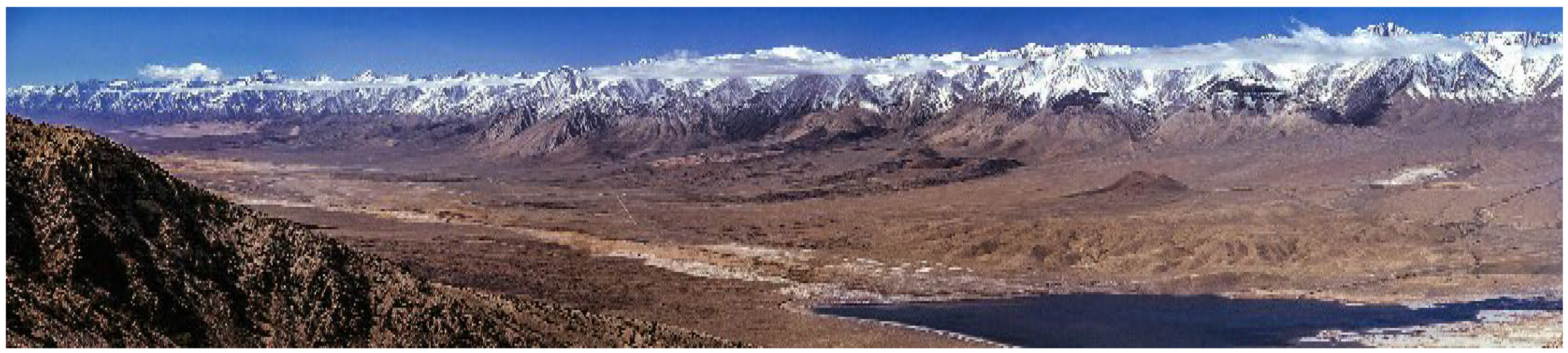
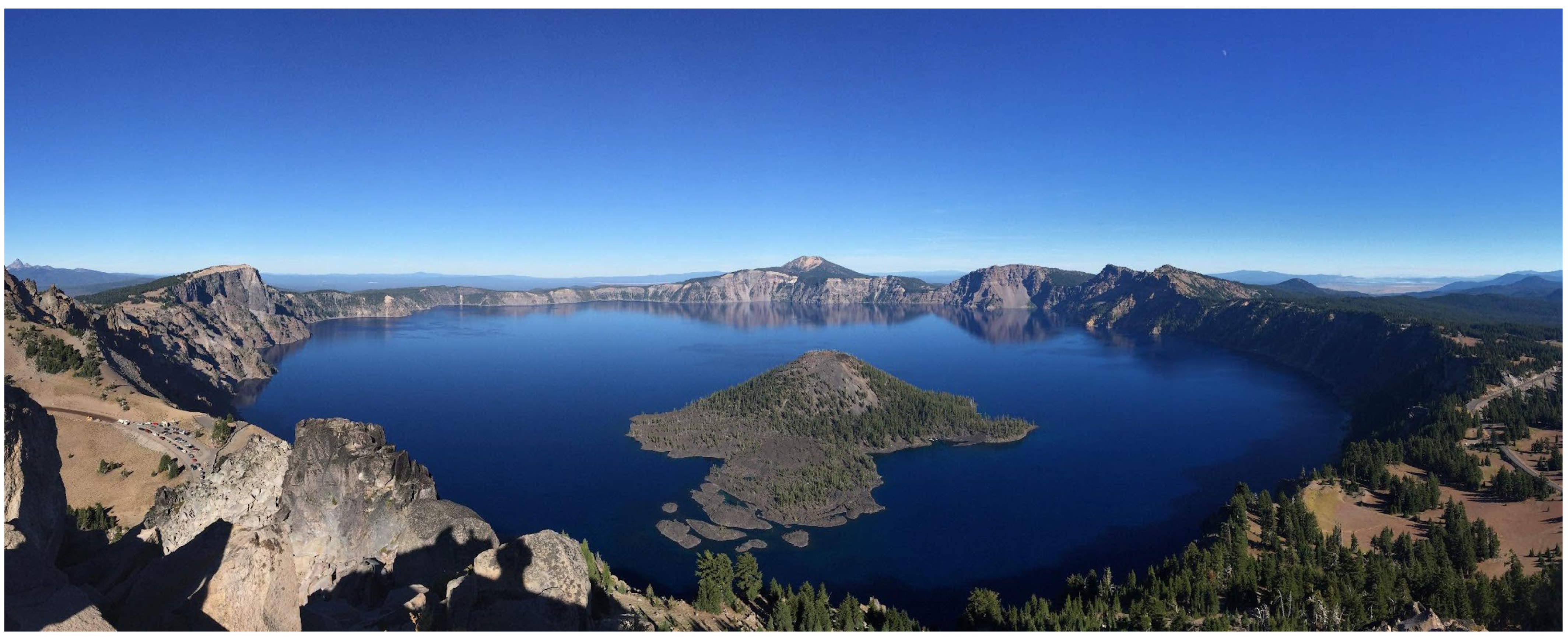


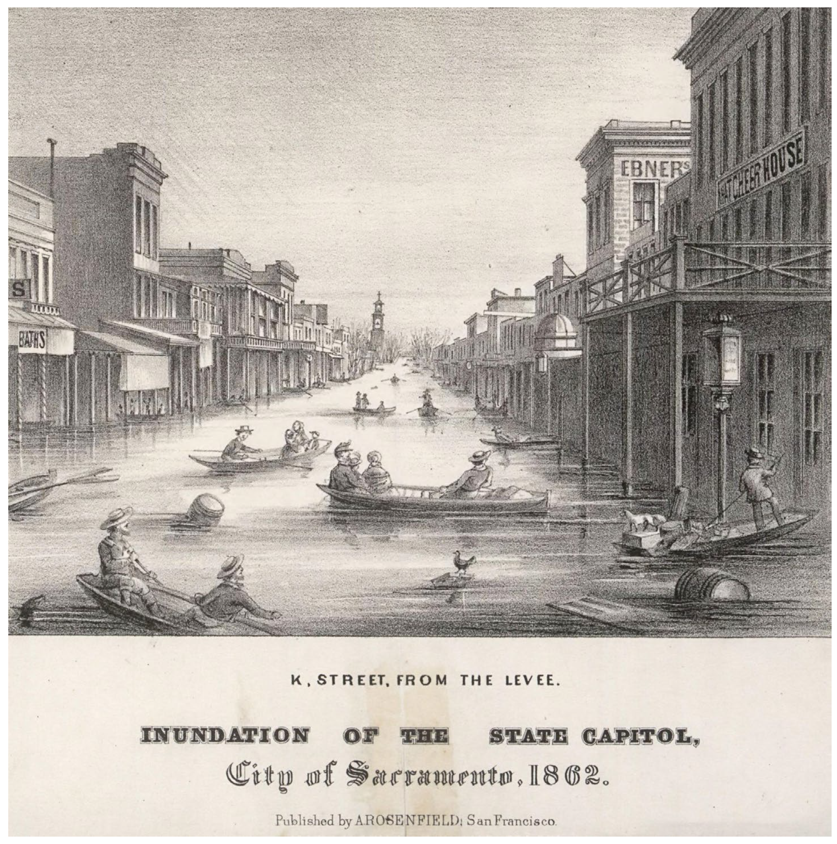
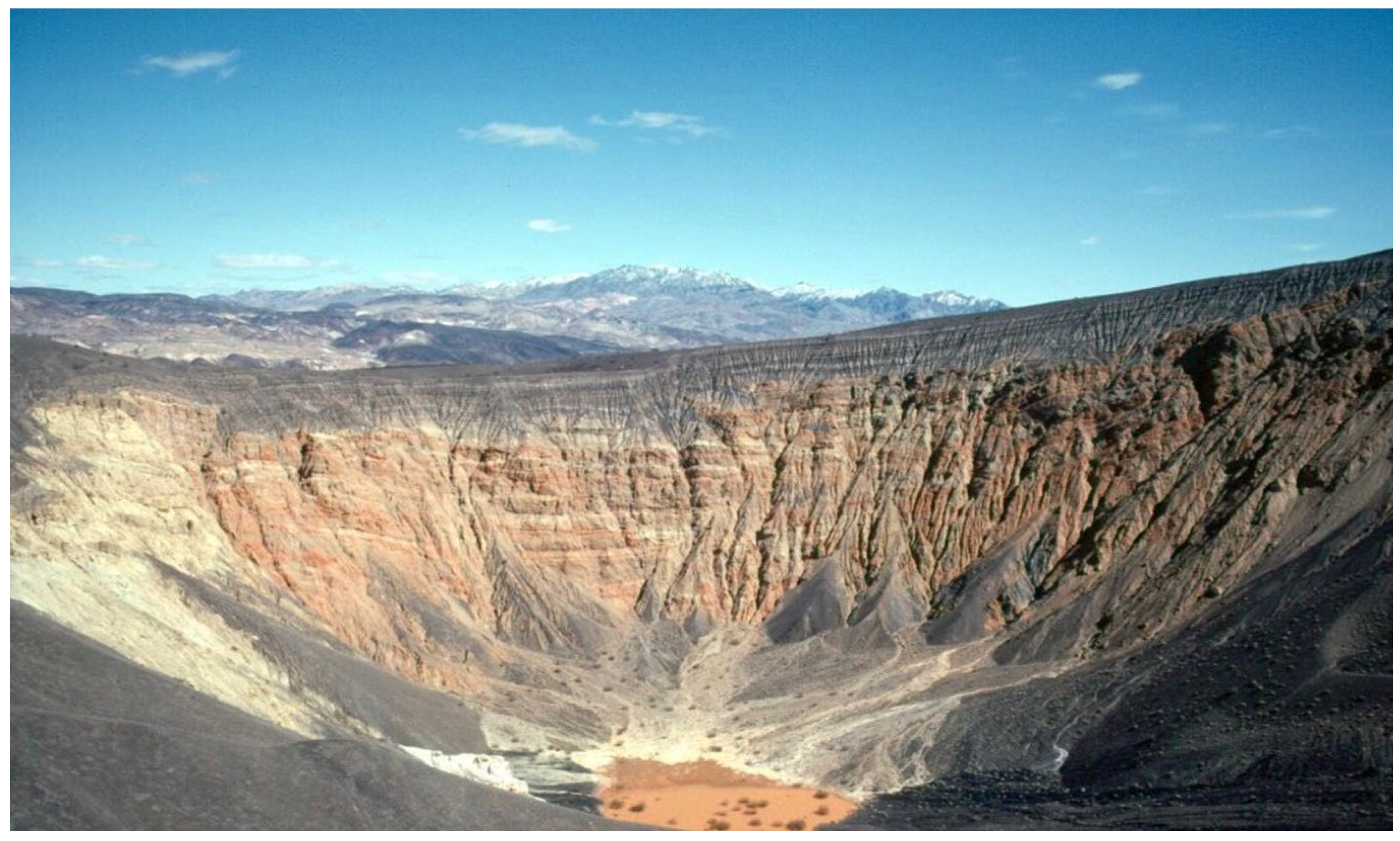


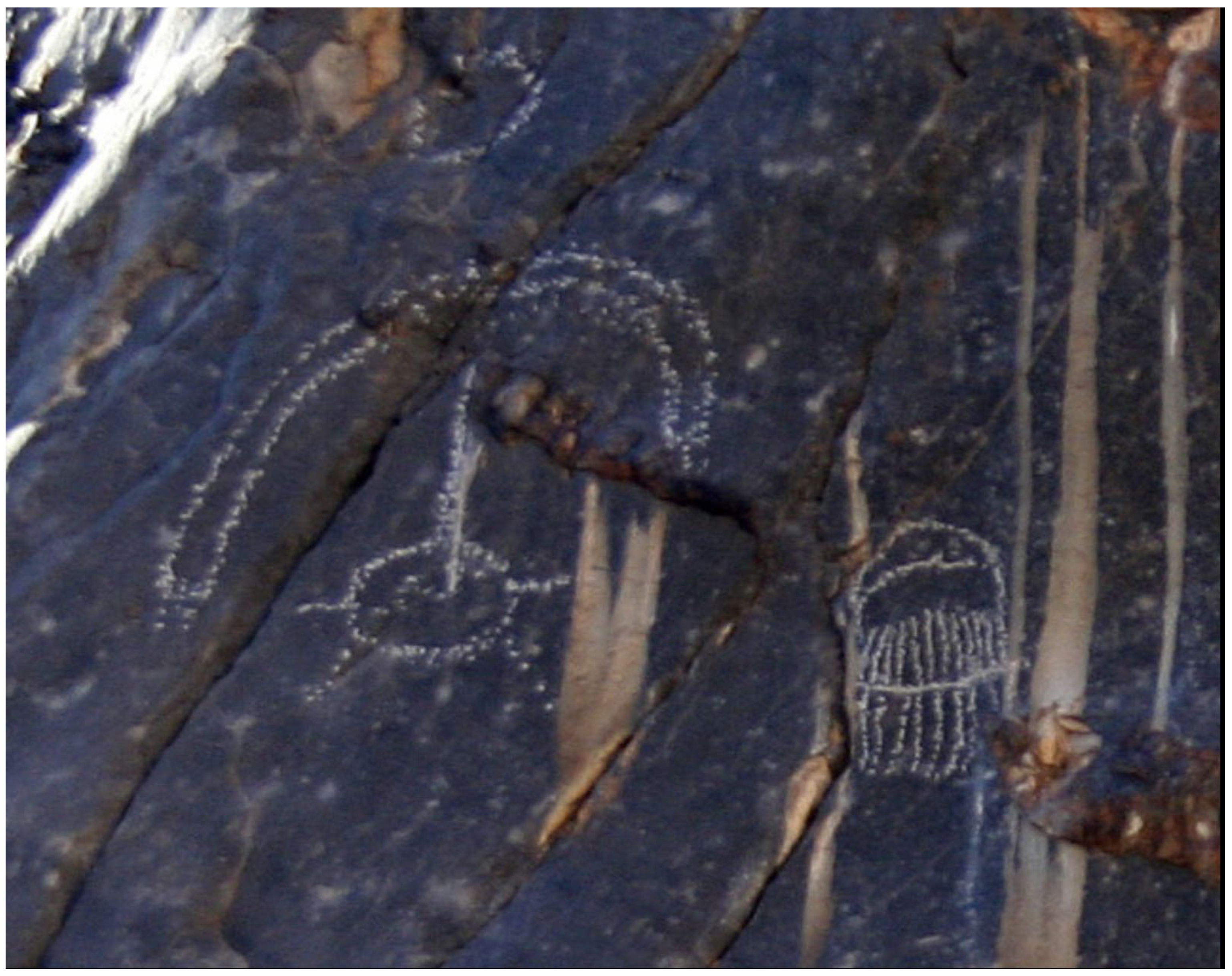
Disclaimer/Publisher’s Note: The statements, opinions and data contained in all publications are solely those of the individual author(s) and contributor(s) and not of MDPI and/or the editor(s). MDPI and/or the editor(s) disclaim responsibility for any injury to people or property resulting from any ideas, methods, instructions or products referred to in the content. |
© 2025 by the author. Licensee MDPI, Basel, Switzerland. This article is an open access article distributed under the terms and conditions of the Creative Commons Attribution (CC BY) license (https://creativecommons.org/licenses/by/4.0/).