1. Introduction
Arab Gulf region cities have similar significant economic, social and environmental characteristics. At the beginning of 1930, oil was discovered in the Arab Gulf region. Significant changes occurred to the social and economic characteristics, which have led to urban growth that caused significant problems in the Arab Gulf region in general and Bahrain in particular. In addition, it continues to experience increasing pressures associated with growth in industries at different levels [
1]. With the large increase in population, inhabited areas have expanded with the rapid urban growth in Bahrain, which is mainly dependent on oil as a major economic catalyst and force.
Energy consumption is continually increasing to satisfy the accelerated needs of the urbanization process, which is relatively high compared to the World average. People in their daily activities attribute this increase in part to the subsidized energy prices, as well as to excessive use of resources. For example, oil production and refining comprise 56.4% of state revenue. In the last few years, dependence on oil has decreased and revenue from the non-oil sectors is gradually increasing. However, revenue from oil will dominate for years to come [
2]. Unfortunately, based on the changing of economic resources, urban development is increasingly progressing in a nonstable manner.
However, the old housing areas have witnessed a variety of improvements. Due to its small size, the State experiences mixed development, industrial areas being located close to residential areas. Consequently, the major impact attributable to energy generation was the changing of consumption patterns.
Accordingly, the residents’ lives within such cities are at risk, due to the deteriorating standards of living resulting from haphazard urbanization. There is an ongoing increasing rate of non-renewable energy consumption in infrastructure issues and services and increased consumption of fossil fuels to operate electrical power plants, sewer plants treatments and water desalination plants, which are serving the civic activities. Besides, there is notable environmental pollution resulting from the adoption of improper methods of waste treatment within urban residential areas [
3].
The growing consumption of energy to serve humanity’s needs, which has disproportionately increased within urban areas, has caused many environmental problems. It has reinforced the urgency to adhere to sustainable urban development plans in many countries. Unfortunately, this problem is prevalent in modern cities in the Arab Gulf region, including Manama [
4].
To provide some background information, Bahrain is an archipelago of 36 low-lying islands and shoals and is a nation of dynamic social and ecological systems, as well as a plethora of accompanying climate-related challenges [
5]. Manama was selected to be the case study for this research because it is the capital of kingdom of Bahrain and one of the oldest urban settlements in the Arab Gulf region. However, the old housing areas have witnessed a variety of developments. Due to its small size, the State has experienced unplanned development, industrial areas being located close to residential areas. Consequently, the major impact was the changing of the consumption patterns cause by increased energy generation. Manama has many urban developing projects, each involving construction of many infrastructure projects. Moreover, many indicators have shown that there are environmental problems detected, which need urgent solutions to control such environmental problems. Urban heat islands (UHIs) and the impacts of Global warming have been sweeping phenomena in Manama and the Bahraini coastal cities [
6]. A UHI is defined as an urban area distinguished by its high temperature compared to its surrounding neighborhood and countryside temperature. Lack of vegetation cover and impervious surface dominance are the main factors behind the rise of UHIs [
7]. Unfortunately, there are not enough studies about UHIs and their impacts in Bahrain or other Arabian Gulf countries.
Like other settlements in the region, Manama has shown continuous urban expansion since the rise of the oil era. Bahrain is an island state, which means that it suffers from limitations of land for urban growth and it should adapt vertical urban expansion [
8]. These conditions are perfect for a UHI to appear. These conditions were investigated and documented using remote sensing technology by Mohammed and Elghonaimy [
9]. A UHI is detected within urban settlements when higher temperature recordings in some places exceed their surrounding areas [
10].
Considering the world climatic changes, the UHI is a critical and complex consequent phenomenon, which can shorten human life expectancy, deteriorate the environmental quality and give rise to economic recession. The Economic Vision 2030 for Bahrain was launched in October 2008, striving to ensure the future economic sustainability of the Kingdom. To contribute to the realization of this Economic Vision, as well as the fulfilment of the Government Action Plan, a new eGov strategy was commissioned. This eGov strategy is considered a priority to control the consumption of non-renewable energy due to unauthorized urban development [
4]. Moreover, The National Plan is proposed to manage the development of Bahrain, seeking to make it a prosperous and innovative country compatible with the 21st Century. The plan addresses several issues such as natural resource preservation, infrastructure development and housing reformation. It also denounces the lack of zoning and dearth of public open space, assuring the need for enhanced urban spaces. The National Plan of Bahrain has illustrated ten key strategies that deal with urban development, the control of real estate manipulation, natural resource protection and guaranteed public access to open space and the waterfront [
11]. This research focuses upon studying Urban Heat Islands in Bahrain from an urban perspective, considering the impact of urban density and limitations of public spaces as main factors behind the rise of urban heat islands in Bahrain.
This research is part of a scientific project that aims to investigate the urban heat island from different aspects. Therefore, the objective of this research is to illustrate the accruing of urban heat islands in the Capital Governorate, Manama city. Moreover, the research reviews the urban activities to point out the main deficiencies giving rise to these urban heat islands and proposes adequate guidelines for controlling UHIs.
2. Methodology
2.1. Study Area
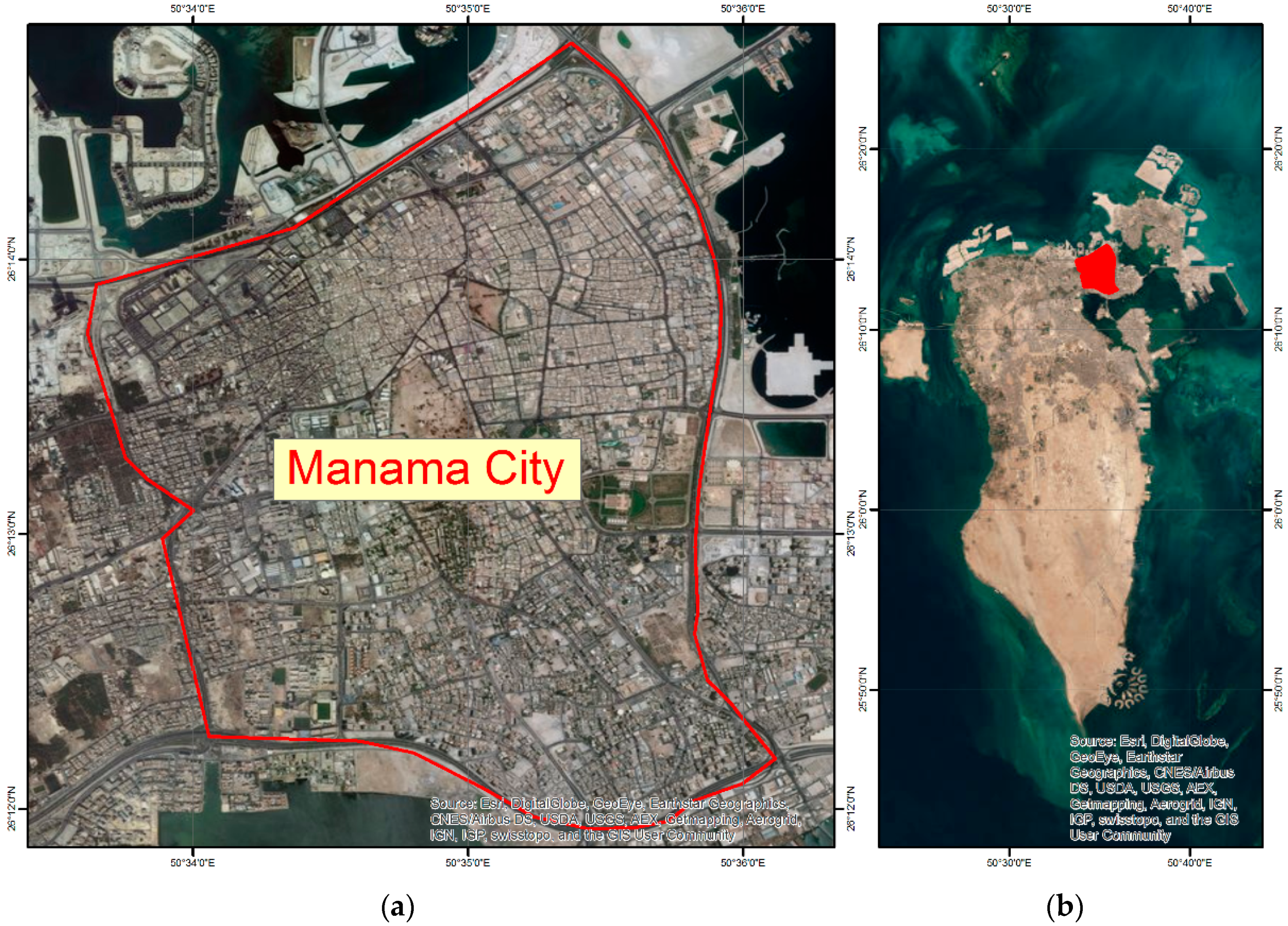
Manama City is the capital of the kingdom of Bahrain and one of the oldest cities in the Arab Gulf Region. Manama city, as shown in
Figure 1, is located in the northeast corner of Bahrain. The population density in the kingdom of Bahrain is high. Manama city, as the capital city in the kingdom, has the most economical, social and cultural activities [
12].
2.2. Remote Sensing Data
For the purpose of this research, a multispectral remote sensing image collected by the Sentinel 2B MSI satellite was downloaded from the United States Geological Survey (USGS) Earth Explorer portal on 19 February 2018. The processing level of the data was level-1C, meaning that the data was orthorectified and radiometrically corrected. Bands number 2, 3, 4 and 8 were selected for use in this research work. These bands were selected because they cover the visible and near infrared regions in the electromagnetic spectrum and have a fine spatial resolution equal to 10 m that make these bands suitable for extracting land cover themes.
In addition, land surface temperature (LST) maps for the kingdom of Bahrain, which were produced by Mohammed and Elghonaimy [
9], were used to investigate the spatial relationship between urban heat islands and other urban factors. Thematic maps were extracted from Landsat 8 TIR 10 band for winter 2017 and summer 2018. Considering the climate of Bahrain—long, hot, humid summers and short, dry winters, with very short Spring and Autumn seasons no longer than two weeks for each—land surface temperature maps for the above-mentioned dates represent the surface temperature geographic patterns for most of the year. Sentinel 2B MSI and LST maps were cropped to match the Manama Metropolitan Area in the north of Bahrain.
2.3. Mapping Land Cover
To map land cover in the study area, a list of five classes was designed to describe land cover conditions, as shown in
Table 1. Four training areas for each class were selected to represent the land cover class in order to create land cover signatures. The generated signatures were fed into the Spectral Angle Mapper Classifier in ENVI 5.3 software to produce a thematic land cover map.
To evaluate the accuracy of the classification process, 800 points were generated in ArcGIS 10.5 using Create Random Points tool. These points covered the study area and were distributed randomly. For each point, the land cover class on the ground was compared to that on the thematic land cover map. The result of this comparison was used to create an accuracy matrix, which was used to evaluate the accuracy of the produced land cover map.
2.4. Evaluation of Solid/Void Conditions
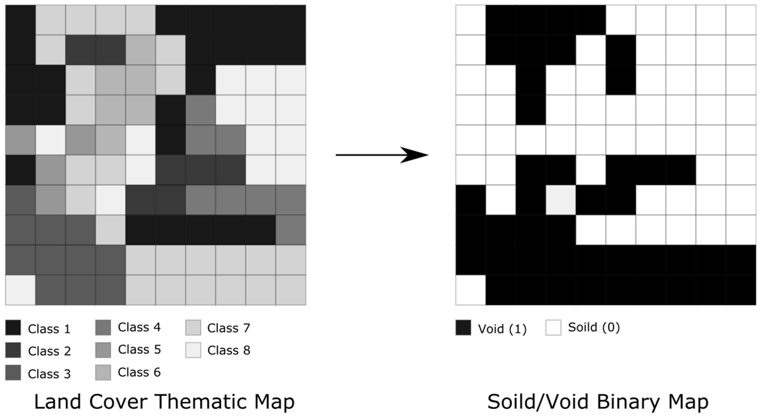
The following analytical approach depended on two hypotheses. The first hypothesis was that a “void” condition was defined as any pixel with no specific land use. The second hypothesis was that the classes that indicated artificial soil and natural soil could be re-described as void.
The analytical approach used in this work to evaluate the conditions of solid/void in the study area was developed based on the analytical strategy of forest fragmentation reported by Riitters et al. [
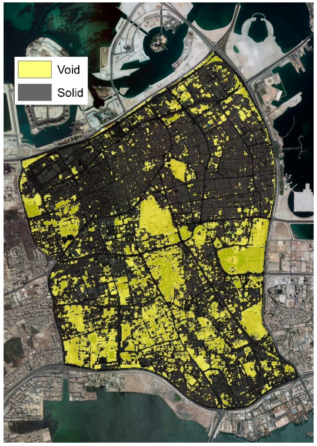
13]. The model began with creation of a binary map to show solid versus void by reclassifying the land cover map. In the solid/void map, any pixel labelled with 0 represented a solid and any pixel labelled 1 represented a void.
Pixels of the classified land cover map were recoded, with all pixels belonging to artificial soil and natural soil recoded as one category and labelled void and all pixels belonging to the building, vegetation and asphalt categories recoded to zero and labelled as solid.
Figure 2 shows the concept of reclassifying the land cover thematic map to produce the solid/void binary map.
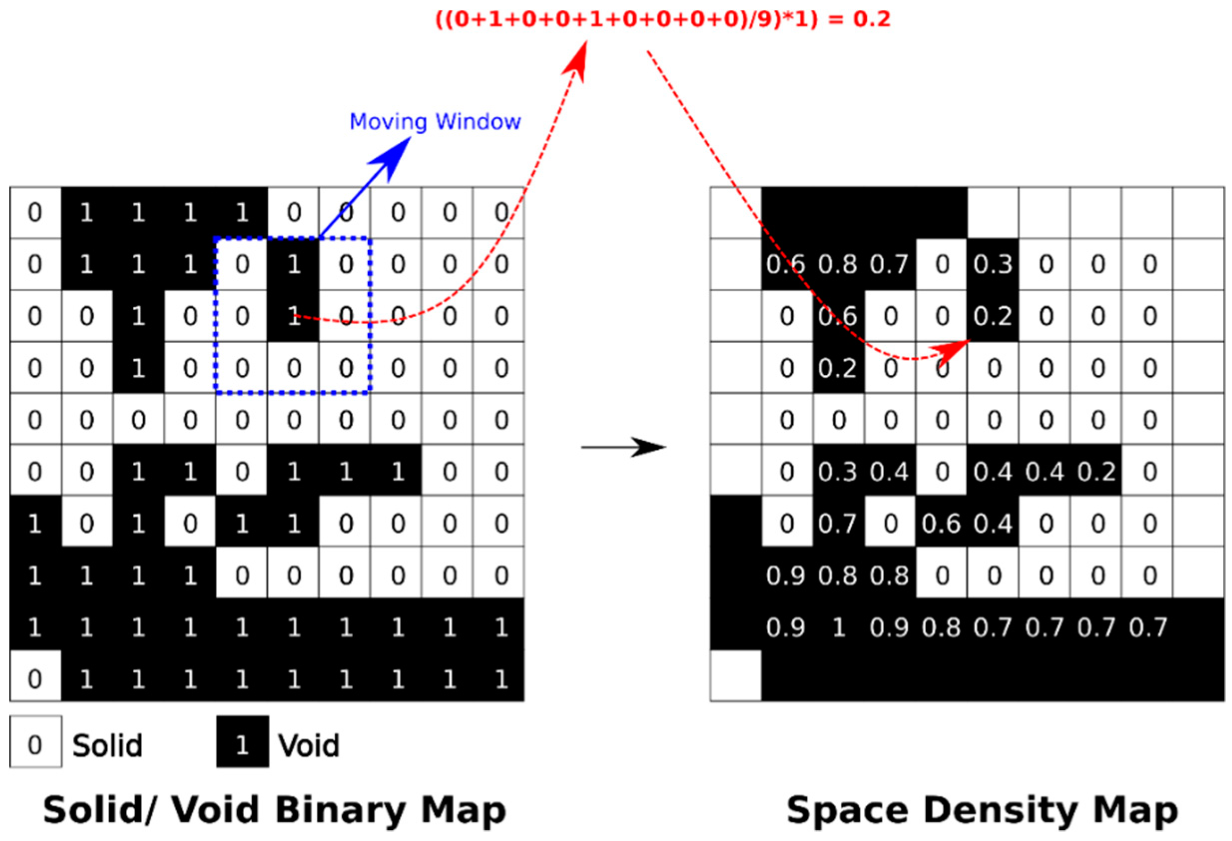
A 3 × 3 moving window was applied to the binary solid/void map to calculate the average pixel value in the window and then it was multiplied by the original value in the binary map. The average pixel value in the kernel of a 3 × 3 moving window represented the density of the void phenomena in this kernel. Multiplication by the kernel pixel value in the solid/void map removed from the calculation all pixels that represented solid phenomena that were labelled zero. This procedure produced a space density map for void phenomena, which is shown in
Figure 3. The Focal Statistics tool in ArcGIS 10.5 was used to produce the average value kernel image and the space density map was produced by multiplying the average value kernel image by the solid/void binary map using the Raster Calculator tool in the same software.
Three types of space could be identified using the space density map, using the following simple rule:
This simple rule was applied using the Reclassify tool in ArcGIS 10.5 and a map was created that showed the anatomy of space in the study area.
3. Results
The rapid urban development and the economic changes in Bahrain cities in general and in Manama in particular, has led to urban concentration of activities. These urban development activities, in terms of quantity and quality, are characterized by the unplanned and haphazard distribution of land uses. Moreover, these developments suffer from the limited area of land for infrastructure and services to serve future urban expansion.
Consequently, Manama is suffering from the conflict between land uses in many ways, such as an imbalance between the needs and the available capabilities of land, overcrowded urban patterns and the unplanned mix of land uses, which are major urban problems. Furthermore, the skyline of the buildings in the area varies tremendously; where some buildings reach five stories high, others have only one floor, which leads to ventilation problems. The absence of proper housing conditions in the city’s residential areas causes many environmental problems. Some indicators of the deterioration of the urban environment have also been found.
This conflict resulted from clashes between development policy, which targets huge changes, the strategic plans that limit urban areas and resources and the action plans implementing the Strategic Bahrain Master Plan. This clash led to missed coordination between the three levels and affected negatively the quality of urban life in Manama city, as outlined in the following sections.
3.1. Urban Heat Islands
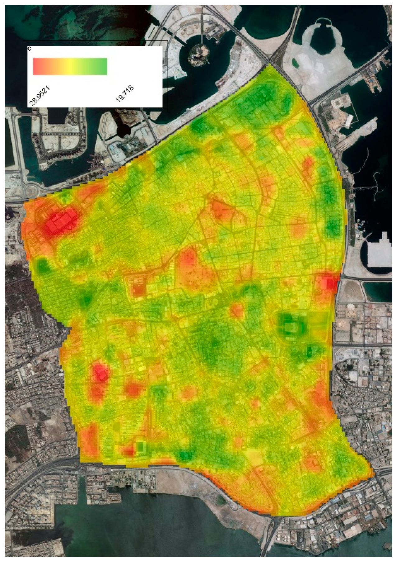
As explained earlier, Manama, the capital of the Kingdom of Bahrain, is considered the main hub of social and economic activities in Bahrain and is significant in terms of political activities. Historically and geographically, Manama’s significance extends to the cities across the Arab Peninsula in general. Moreover, from the analysis it was concluded that the scattered UHIs in Bahrain were presented clearly in general and in Manama in particular. For two different seasons, the study showed these thermal pockets in summer and winter for Land Surface Temperature (LST).
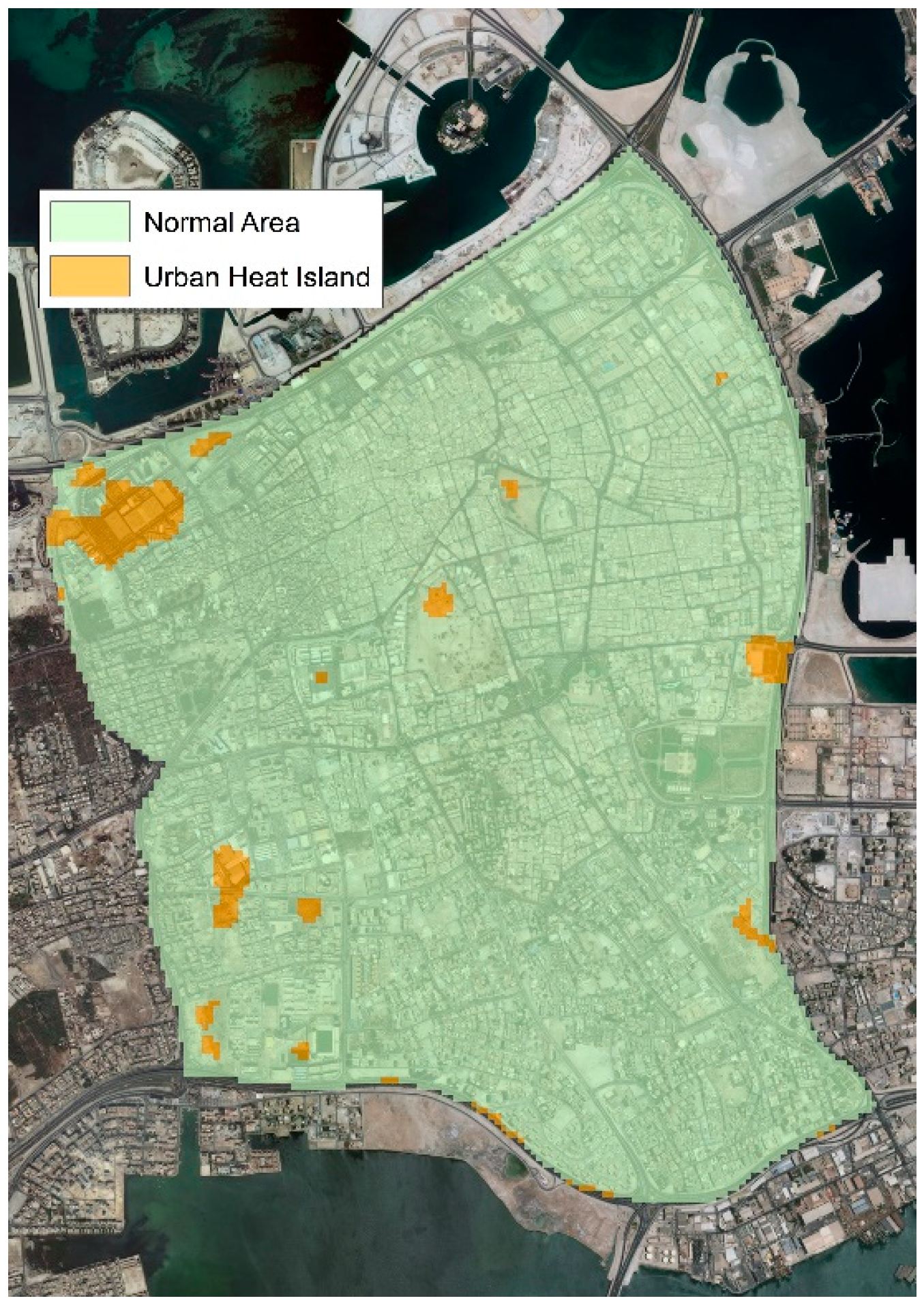
Figure 4 shows the distribution of land surface temperature over Manama City in the winter of 2017. The red spots point to these areas, which had exceptionally high temperature compared to their neighborhoods, considering the regular average temperature at this time of the year.
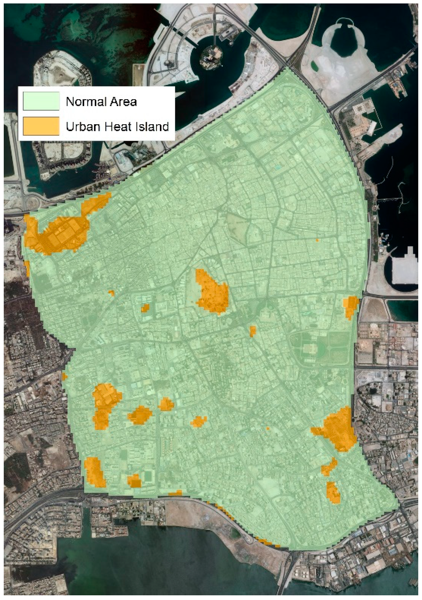
Figure 5 shows the same phenomena in summer 2018.
Urban heat islands were defined, based on this data, to be the areas with the most extreme temperature in the area. The areas with land surface temperatures over 25 °C were labelled as winter urban heat islands and the areas with land surface temperatures over 45 °C were labelled as summer urban heat islands.
Figure 6 and
Figure 7 show the urban heat islands in Bahrain city in winter and summer, respectively. It is evident that the areas of urban heat islands in the summer were larger than those in the winter. The area of urban heat islands in the winter was 0.4203 km
2, whereas in the summer it was 0.909 km
2.
3.2. Land Cover
From analyzing the site visits and observation of the collected data about the Capital governorate urban pattern, it is evident that Manama is suffering from conflict in land uses. This conflict resulted from the clash between the general policy and the action plans. Moreover, it showed that the city suffers from a shortage of proper design and use of the urban open spaces and greenery at various areas of the city, which is leading to an acceleration of the emergence of the heat islands phenomenon. In
Figure 6 and
Figure 7, the study shows the exact pockets of the urban heat islands within the urban fabric.
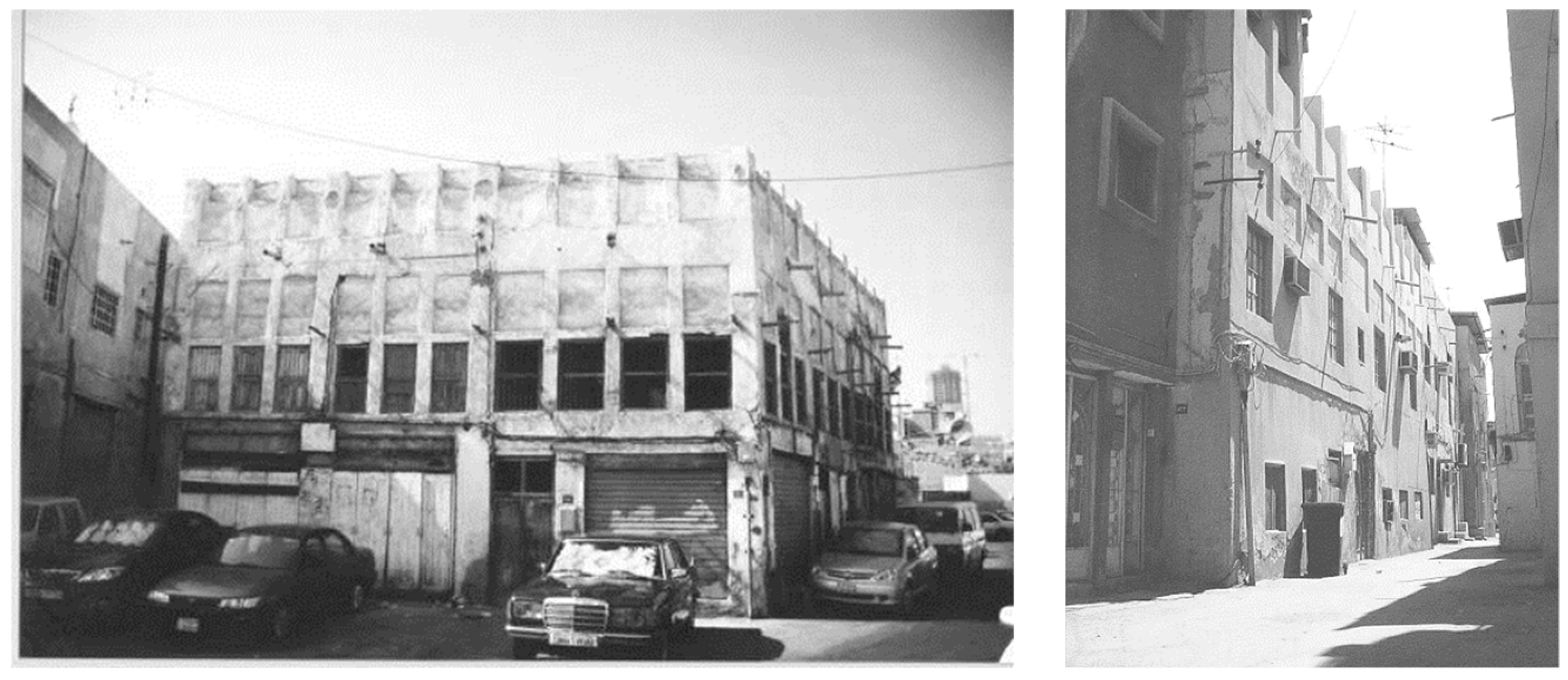
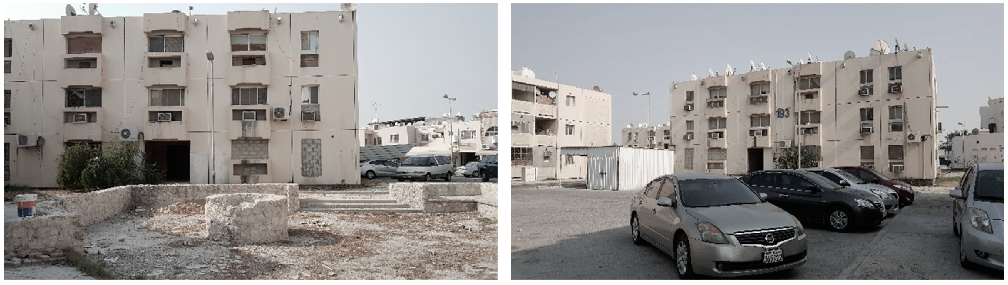
The field study examined and analyzed the thermal images to understand the reasons for the location of these pockets. It showed that one of the main pockets is located in the Manama Central Market area due to the high concentration of air conditioners as well as the small packaging workshops in the surroundings (
Figure 8).
Moreover, to the east, one of the pockets is located within the sewer treatment plant zone in the “Tobly” district. In addition, in the middle and the south, some pockets are scattered due to the deteriorating percentage of green areas as well as the low ratio of vacant parts in the area, which are shown in
Table 2.
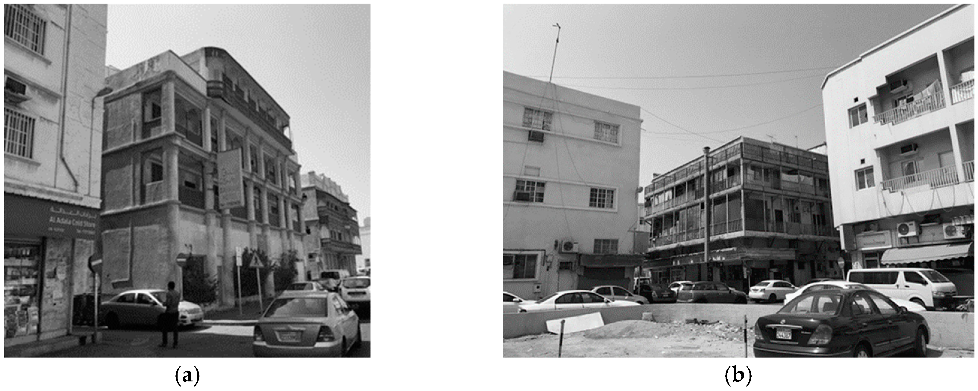
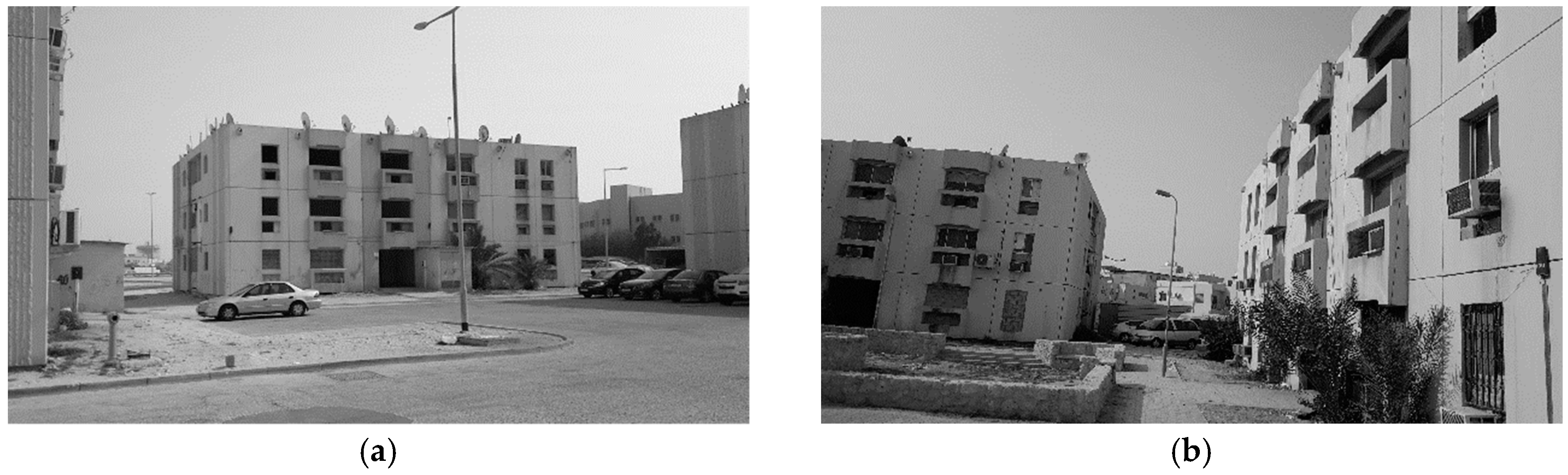
Furthermore, as explained earlier, this part of the city is the old part, which faces dramatic changes regarding its economic activities. Buildings in these areas are traditional buildings with no active thermal treatments. The frequent change of social structure affects the social activities as well. Accordingly, a change of roof use from places of social gathering and activities towards places for storage and waste became a major problem for building roofs. This misuse created hazardous situations in term of causing fires and other hazards in the area (
Figure 9).
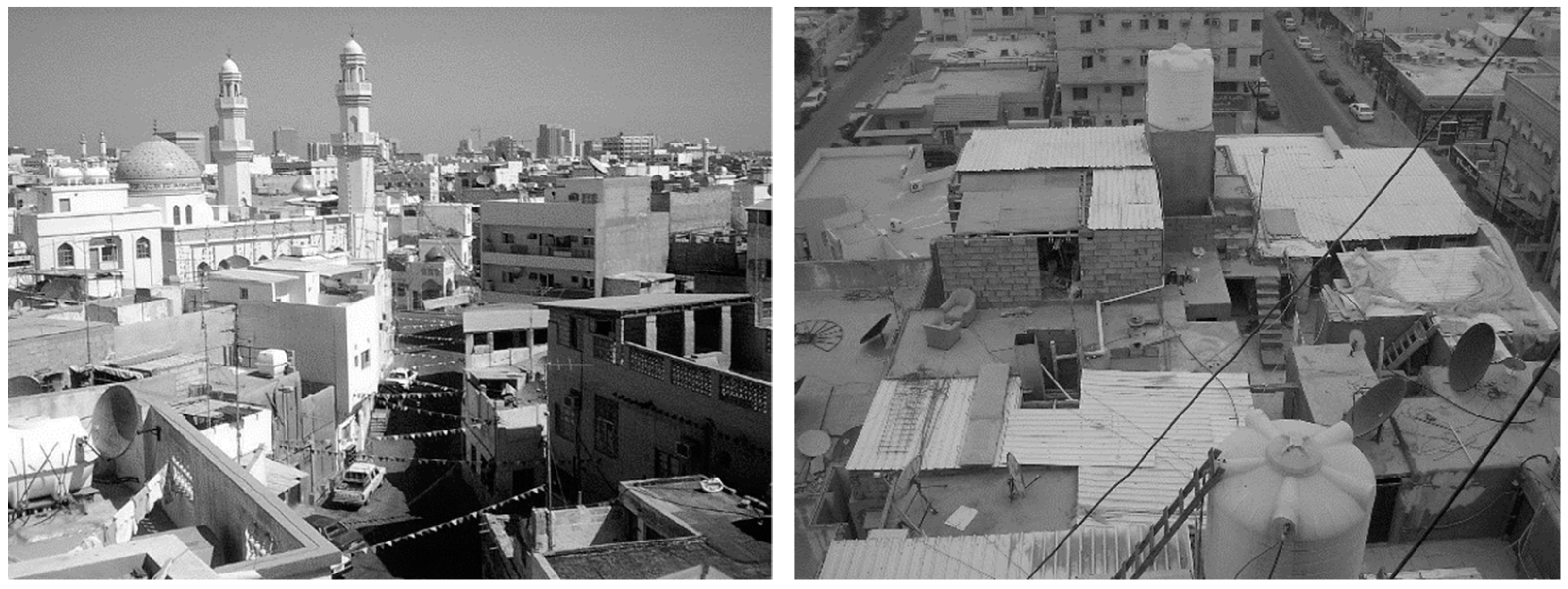
Moreover, the use of inappropriate finishing materials for the roofs, which were made of cement tiles, with the absence of thermal insulation of building facades, played the main role in spreading these thermal pockets. Dark asphalt pavements scattered without greenery in the sidewalks or the middle road islands led to the same result [
14] (
Figure 10 and
Figure 11).
The rapid urbanization and change of land use patterns led to loss of one of the significant characteristics of the old city. Losing road orientations and changing the staggering of building heights led to a low percentage of airflow and increased the humidity in the area, which also increased the air temperature as well [
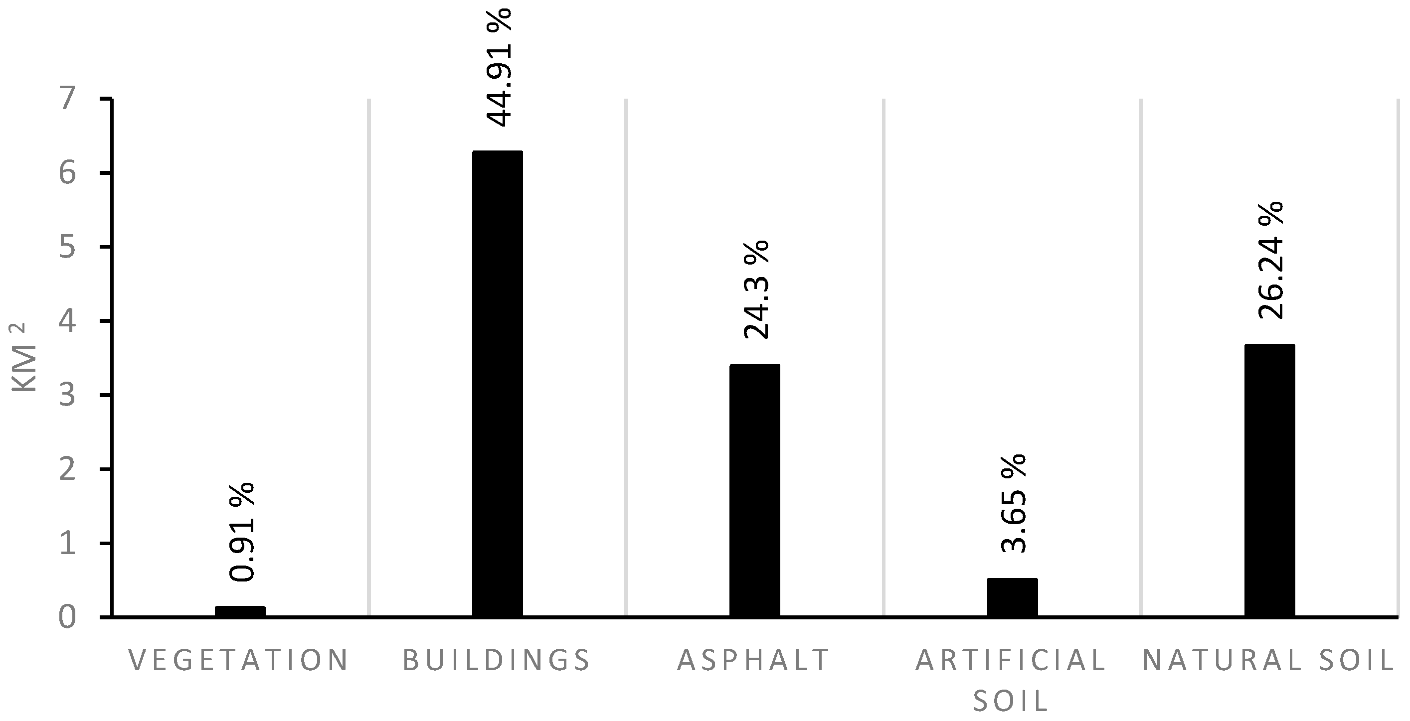
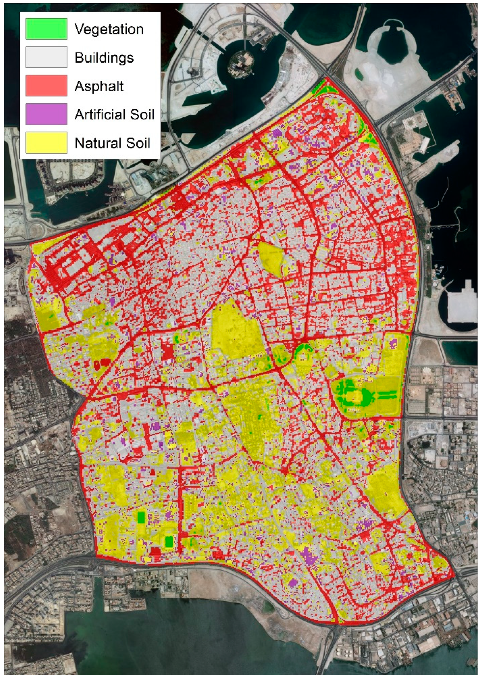
14]. The area occupied by each land cover class in km
2 is shown in
Figure 12, while
Figure 13 shows the land cover thematic map for the study area. It is evident that the dominant terrestrial land cover class was the buildings class (45%), then the natural soil (26%) and then Asphalt (24%). Within the pilot study, Vegetation and artificial soil were tiny areas. They together represented about 5% of the total area of Bahrain.
Comparing the land cover pattern inside urban heat islands to their inside common area highlighted the relationship between urban heat island and some urban factors.
Table 2 shows the area of the land cover classes inside urban heat islands and inside the average field in square kilometer in winter, where
Table 3 shows the same subject but in summer.
The area of UHIs in winter season in Manama city was about 0.4 km2, which was less than 3% of the total Manama city area. The dominant land cover classes were Buildings, Asphalt and Natural Soil. Note that the area of vegetation in the urban heat islands was less than 0.02% of total area of Bahrain but inside the neighboring area, the percentage of vegetation was about 0.7% of Manama’s area.
In the summer season, the area of urban heat islands in Manama city enlarged to 0.9 km2, which was about 6.4% of the Manama area. The dominant land cover classes were still Buildings, natural soil and Asphalt. The vegetation percentage was still less than 0.02% of the Manama area.
3.3. Solid and Void
Following what was explained earlier in
Section 3.1, most of the urban pattern has become a “concrete forest” with a shortage of greenery. It was observed that most of the roofs lost some necessary features as well; however, the concept of “ECO” technology is essential in designing smart and green roofs. It is now one of the trends leading to sustainability in countries [
15].
Figure 14 shows the solid/void binary map over the study area. It was evident that the eastern part of the study area, where the central and older parts of the Bahrain Metropolitan area are located, were predominantly solid. Conversely, in the western part, void spaces were dominant. The area occupied by solid was 9.67 km
2 or 69% of the Manama area, whereas the void was 4.3 km
2 or 31% of the Manama area.
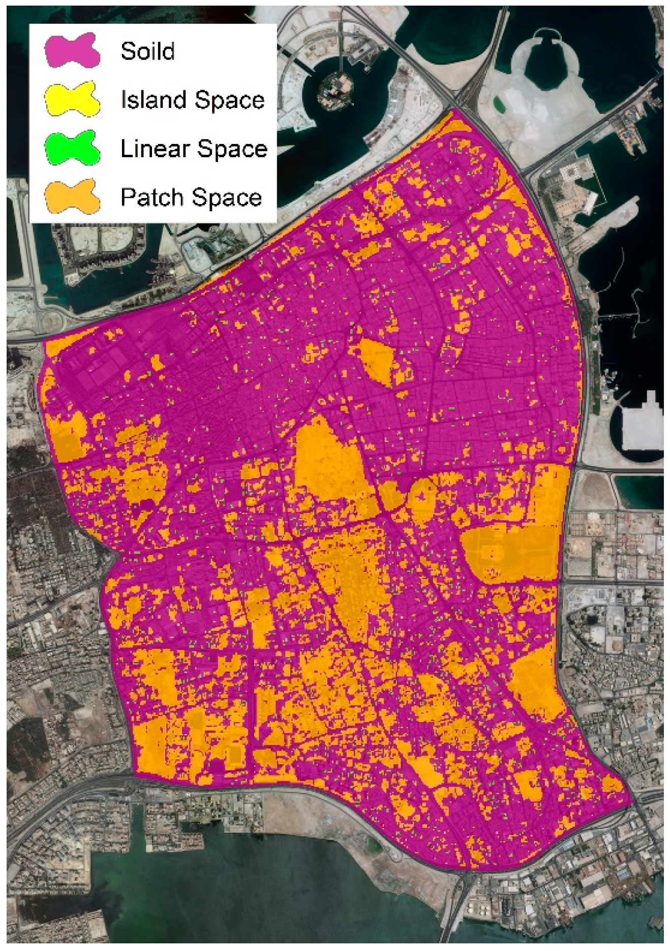
Applying the simple rule mentioned in Equation (1) to the solid/void binary map produced the space density map, which was used to create a map of solid and void types that is shown in
Figure 15.
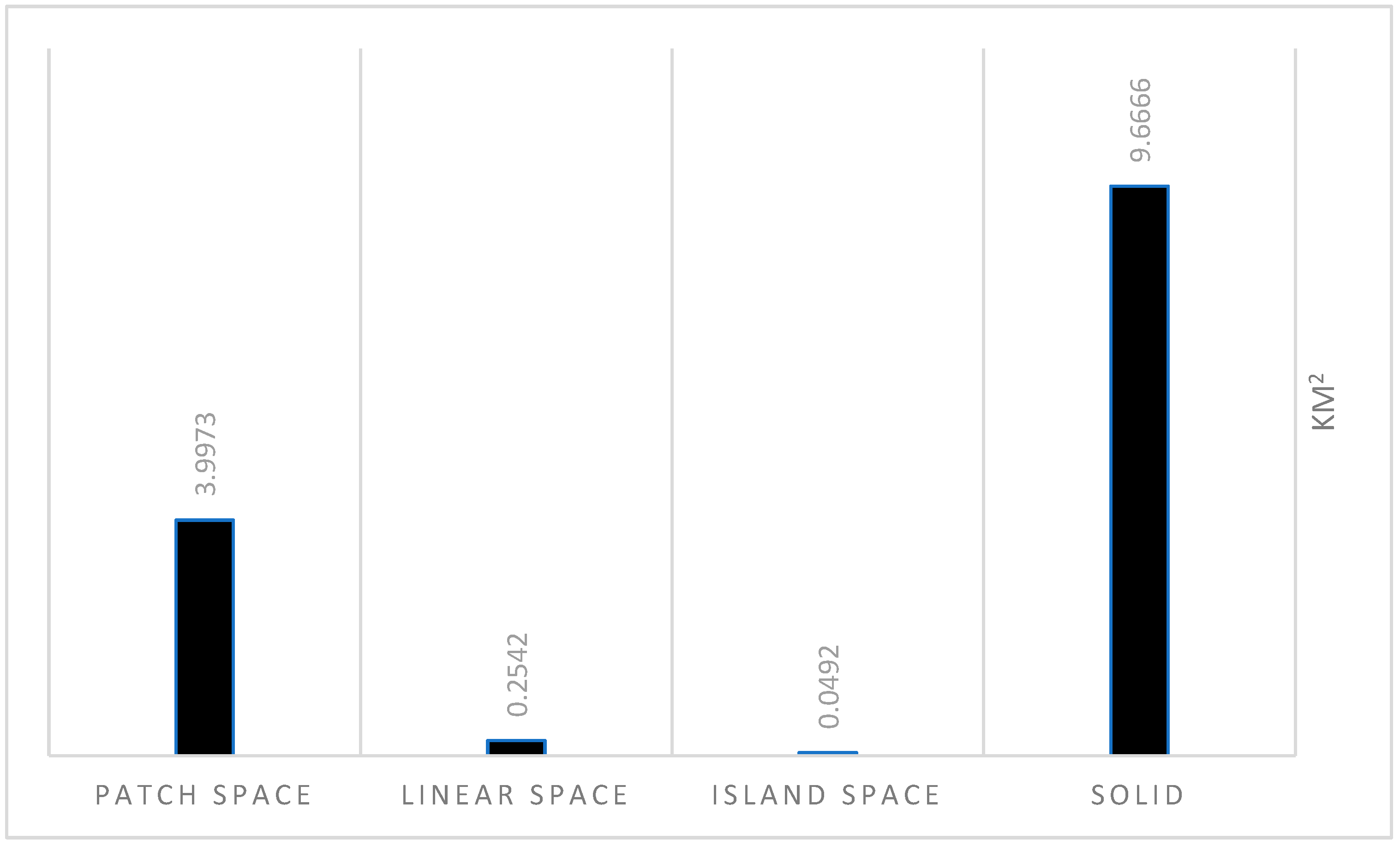
Figure 15 shows every solid/void type and their area in km
2. The dominant void type was patch space. However, the island and linear space types occupied a small area comparing to this area occupied by patch space.
Overlaying solid and void maps to maps of urban heat islands in winter and summer showed the influence of solid and void areas in urban heat islands.
Table 4 shows the area distribution of solid and void in urban heat islands and the neighboring area in winter, while
Table 5 shows the same information but in the summer. The areas in these tables were calculated in square km.
In winter, inside urban heat islands, solid was 0.26 km
2, whereas void was about 0.14 km
2. This means that in winter, urban heat islands consisted of approximately twice the solid area as the void area. In summer, the area of urban heat islands increased and the solid occupied about 0.44 km
2, which was similar to the void area (
Figure 16).
Moreover, in the study areas, observations were made as to why urban heat islands were varying between the Central Market, infrastructure plants (water desalination, sewer treatments and power plants) and the scattered workshops and the small industrial activities (glass and metal workshops) [
16].
4. Discussion
Based on the previous results from the practical study, the UHI area in Manama City is less in the winter than in the summer, which means that the microclimate of Manama City is a hidden factor in the phenomenon of urban heat island increase.
UHIs of Manama city are distinguished by two main characteristics. First, there is a dominance of artificial land cover, like buildings and asphalt and little vegetation land cover (
Figure 17).
Second, the void area is less than or equal to the solid area, which results in a problem in the ventilation of the urban heat islands. Roofs of buildings are the most exposed parts to environmental conditions in terms of heat absorbance and transmission towards buildings. Therefore, with the low ratio of greenery in the area, it is necessary to find a way to increase the missing greenery but the area suffers from the low percentage of vacant areas that could be used as parks (
Figure 18 and
Figure 19).
Consequently, the concept of sustainability should be in the vision of the proposed solutions and should be considered while presenting the general guidelines for controlling urban heat islands in Manama. In particular, the “ECO” concept is significant in treating the roofs, facades and building materials of the power, sewer and potable water plants, as well as in methods of paving roads and using materials.
Moreover, there is an acute need to examine the UHI in Bahrain in general and in Manama in particular. Priority should be given to solving conflicts between developing policy and strategy plans and implementing action plans to manage Manama urban development as follows:
Kingdom (Regional) level: The subject of controlling UHIs should be added to the annual review for the Bahrain national strategy 2030. In addition, accurate coordination between the infrastructure facilities and the urban activities should be organized.
City (Governmental) level:
Enhancing the characteristics of the open spaces and developing landscape architecture work in terms of social, economic and environmental facilities.
Removing the causal sources of thermal pockets in districts.
Relocating the Central Market, scattered workshops and the small industrial activities in some areas (glass and metal workshops).
Districts (Neighborhood) level:
Considering a monitoring plan of thermal pockets within the urban context.
Preparing a ‘comprehensive action’ plan targeting the improvement of the vacant lands and the planned open spaces within the Manama urban context.
Increasing the greenery ratio in the study area could be done in many ways, such as designing a green envelop for buildings in terms of green roofs and green facades. In addition, having greenery for roofs and facades of the buildings is significant as an insulation system.
Organizing design guidelines for using green envelops for building roofs and facades to treat the existing concrete forest.
Using alternative materials for street paving different from the existing asphalt.


