Article

Research on the Layout of Courtyard Space in Underground Commercial Streets

1
School of Architecture and Art, Hebei University of Engineering, Handan 056000, China
2
China Academy of Building Research, Beijing 100013, China
*
Authors to whom correspondence should be addressed.
Buildings 2025, 15(9), 1549; https://doi.org/10.3390/buildings15091549
Submission received: 4 March 2025 / Revised: 17 April 2025 / Accepted: 27 April 2025 / Published: 4 May 2025
(This article belongs to the Section Architectural Design, Urban Science, and Real Estate)

Abstract

Underground pedestrian streets play a crucial role in urban spatial systems, yet the positioning of atrium spaces in existing underground walkways is often determined empirically without adequate consideration of spatial rationality in relation to public environmental behavior. Properly designed atrium spaces can significantly enhance spatial quality and pedestrian experience, effectively revitalizing underground environments. This research investigates the rationality of atrium spatial distribution in underground pedestrian streets, with particular emphasis on developing an evaluation framework for assessing atrium layout appropriateness, using pedestrian congregation patterns shaped by spatial network morphology as the primary evaluation criterion. Through comprehensive field observations and computational simulations, the study examines the interaction between existing underground street network configurations and pedestrian behavior, pioneering the application of spatial design network analysis (sDNA) technology to optimize atrium spatial positioning strategies, thereby establishing a more scientific methodology for atrium layout planning. The proposed approach was validated through a case study of Longhu Underground Pedestrian Street in Handan, ultimately providing a systematic method for verifying atrium distribution rationality. The research establishes an innovative framework that integrates computational analysis into underground spatial planning, incorporates pedestrian flow prediction into architectural design processes, and embeds performance-based evaluation into urban renewal initiatives. Findings demonstrate that sDNA technology can accurately predict pedestrian congregation patterns across various underground street configurations, providing a data-driven foundation for assessing atrium location rationality and supporting the optimization of existing underground spaces. These outcomes are expected to offer valuable scientific references for the design and improvement of atrium spatial distribution in future underground pedestrian systems.

1. Introduction

In contemporary urban environments, the efficient utilization of underground pedestrian streets has become a critical aspect of urban planning, contributing not only to the diversification of commercial spaces but also to the revitalization of urban life [1]. Atrium spaces—key nodes connecting underground areas with the ground level—are characterized by openness, transparency, and the introduction of natural light and ventilation, all of which significantly enhance the comfort and environmental quality of subterranean spaces [2,3,4]. These features are essential for improving both the environmental experience and the commercial value of underground pedestrian networks. Furthermore, the spatial configuration of atriums plays a vital role in promoting commercial activity and directing pedestrian circulation [5]. A thoughtfully designed atrium layout can substantially increase the attractiveness and competitiveness of underground pedestrian streets.
However, the current design and utilization of atrium spaces in underground pedestrian streets still face numerous shortcomings (Figure 1). Many existing atrium spaces show no pedestrian gathering, while areas with high pedestrian concentration tend to have dim lighting conditions, failing to provide comfortable illumination and resulting in poor spatial experience. In particular, there is a lack of relevant references for the spatial arrangement of atrium locations, with decisions often relying solely on design experience rather than scientific evidence. This approach to determining the placement of atrium spaces within underground commercial streets lacks a robust theoretical foundation [6,7,8,9,10,11,12]. Therefore, this study delves into the spatial arrangement of atrium spaces in underground pedestrian streets, aiming to explore optimization strategies and functional enhancements for their placement [13,14,15,16,17,18]. By doing so, it seeks to ensure that underground atrium spaces better align with the rapid development of urban areas and meet the demands of modern human habitats [19,20,21].
Current research on underground atrium spaces remains relatively limited, with most scholarly attention focused on critical operational aspects such as emergency evacuation, ventilation and daylighting, thermal comfort, wayfinding, and acoustic performance in underground pedestrian street atriums. Kareem S. Galal [22] investigated optimal roof materials for atriums in Lebanon’s coastal region, achieving balanced daylight penetration and thermal gain control. Through virtual reality simulations integrated with eye-tracking technology, Yue Liang [23] established design principles for skylight configurations in underground spaces based on environmental psychology and spatial cognition theories. Hai-Rong Wang et al. [24] developed smoke control and evacuation strategies for typical building atriums, ensuring rapid occupant egress during emergencies. In acoustic performance studies, Rozhin Naeemaee et al. [25] employed a multimodal approach combining field measurements, surveys, ray-tracing simulations, and auditory tests, identifying optimal early decay time (EDT) ranges (1.00 s < EDT ≤ 1.95 s) for occupant preference. Lili Dong’s team [26] conducted parametric daylight optimization for Chongqing’s underground commercial atriums using orthogonal analysis, revealing that configurations with 1–3 square atriums, 5°–10° profile inclinations, and 1:6 skylight aspect ratios could reduce energy consumption by 18–23%.
Climate-responsive design investigations by Xian-Xing Shi [27] established photothermal performance patterns in cold-region underground atriums through Ladybug + Honeybee simulations, quantifying how geometric parameters affect subsurface thermal-luminous environments. Complementing this, Chao-Nan Xue [28] employed DesignBuilder simulations to optimize Shanghai’s commercial underground atriums, demonstrating that skylight-to-floor ratios exceeding 25%, polygonal configurations, and Al-Mg alloy shading materials collectively enhance photothermal environment quality by 31–37%. R. Carli et al. [29] proposed a multi-objective optimization algorithm to enhance building energy efficiency, sustainability, and occupant comfort through an integrated computational framework. Their approach systematically balances competing design objectives, offering a data-driven solution for performance-driven architectural design. S. Pourzeynali et al. [30] employed a genetic algorithm (GA) to determine the optimal parameters of a base isolation system, simultaneously minimizing displacement responses at both the top floor and the isolation layer of the structure. This computational approach enhances seismic resilience by balancing structural flexibility and stability. In a related optimization study, Miguel A. et al. [31] developed a mixed-integer linear programming (MILP) model to optimize the selection, sizing, and capacity allocation of combined heat and power (CHP) systems in tertiary-sector buildings. Their framework improves energy efficiency and cost-effectiveness by systematically determining equipment configurations.
The optimization of atrium space layout discussed in this paper refers specifically to the spatial positioning of atrium nodes within the overall underground pedestrian system, as illustrated in Figure 2, rather than the arrangement of interior elements within the atrium itself. This study primarily examines pedestrian behavior patterns [32,33,34,35,36] to assess the rationality of existing underground street and atrium layouts [37,38], with the aim of proposing more effective spatial configurations for atrium placement [39]. The objective is to align atrium node locations with pedestrian movement tendencies, thereby enhancing spatial comfort and revitalizing the overall environment of underground pedestrian streets [40,41,42,43].

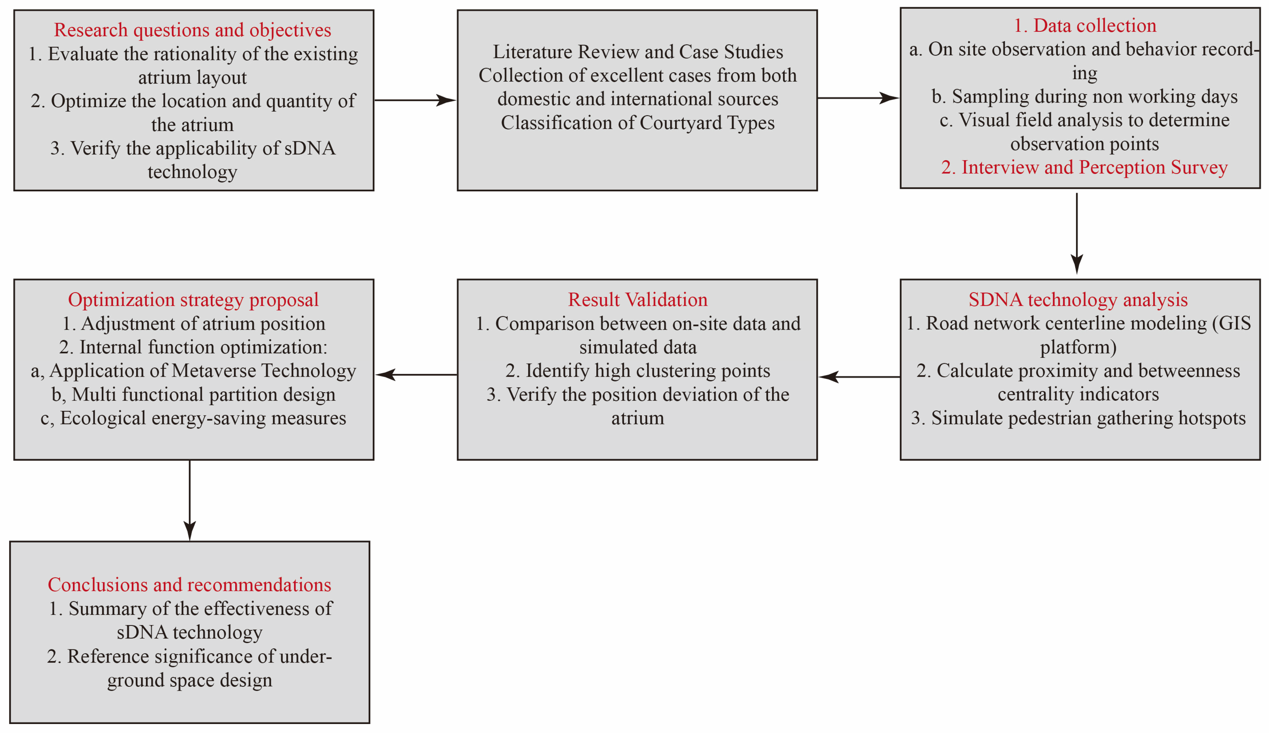
2. Materials and Methods

The atrium spaces examined in this study are defined as expansive transitional zones that establish vertical connectivity between surface and subterranean levels, distinct from conventional transportation nodes [44,45,46,47]. These multifunctional hubs are predominantly situated beneath skylight structures functioning as high-capacity pedestrian aggregation areas, or configured as sunken plazas within central segments of underground pedestrian networks [48,49,50]. Through systematic analysis of representative cases across global urban contexts (Figure 3), six typological classifications of underground atriums were identified: (1) cantilevered skylight, (2) recessed skylight, (3) planar skylight, (4) full-height glazed, (5) open plaza, and (6) enclosed atrium configurations (Figure 4). Each typology demonstrates unique spatial characteristics and functional specializations, ranging from visual permeability enhancement to crowd flow management [51,52].
As a key node within underground pedestrian networks, the spatial positioning of an atrium is critically important [53,54,55]. In addition to facilitating natural ventilation, atriums allow the penetration of daylight into subterranean spaces, thereby contributing to reduced energy consumption [56,57,58]. Moreover, they function as visual landmarks, aiding pedestrian wayfinding and orientation. This study aims to identify optimal atrium placement based on pedestrian behavior, utilizing spatial design network analysis (SDNA) [59]. Consequently, environmental factors such as wind, thermal comfort, and natural lighting conditions are not within the scope of this investigation.
Through a systematic analysis of representative case studies across diverse urban contexts, this study finds that atrium spaces consistently register the highest pedestrian densities within underground pedestrian networks. These high-traffic nodes are often integrated with multifunctional design elements—such as seating areas, daylighting systems, biophilic landscaping, and performance zones—which collectively contribute to improved spatial comfort [60,61,62,63]. Behavioral observations further reveal extended dwell times and frequent social interactions within these spaces, suggesting significantly elevated levels of spatial vitality [64].

2.1. Research Questions

At present, most of the design for the atrium space of underground pedestrian streets is arranged by relying on subjective factors, and there is no set of reasonable scientific and data-based layout design methods. Therefore, the article starts from quantitative analysis, takes the pedestrian vitality in the underground pedestrian street as the entry point, and explores the reasonable layout of the atrium space in line with the pedestrian behavior. The main research questions encompass the following:
(I).
Exploring whether the existing atrium layout fits the pedestrian gathering behavior in this pedestrian street.
(II).
Exploring whether the location and quantity of the atrium layout can provide a comfortable and high-quality spatial environment for pedestrians.
(III).
Exploring the application of sDNA technology based on spatial syntax in underground space.

2.2. Selection of Research Subjects and Collection of Research Data

There are five standalone underground commercial streets within the central urban area of Handan. Field investigations and observational studies reveal that the Sunshine Longhu Underground Commercial Street experiences the highest pedestrian flow and is equipped with a daylighting atrium. This configuration not only ensures the reliability of the research data but also provides a suitable basis for comparative analysis through simulation, thereby improving the overall accuracy of the study.
Located east of Fudong Street and south of Renmin Road, the Sunshine Longhu Underground Pedestrian Street is an independent underground space adjacent to Longhu Urban Park. To the east lie the Handan Grand Theatre and Meile City Shopping Mall, while the Hilton Hotel is situated to the south. The street features two entrances—both designed as sunken plazas—positioned at the northern and southern ends, as well as a single daylighting atrium. Its geographical location is notably advantageous in terms of accessibility and connectivity.
This study systematically documents the behavioral patterns of various pedestrian groups through comprehensive on-site observations. Methods such as photography and video recording are employed to annotate pedestrian activities in detail. Additionally, in-depth interviews are conducted to explore environmental perceptions and evaluations of underground pedestrian streets from the perspective of different user groups.

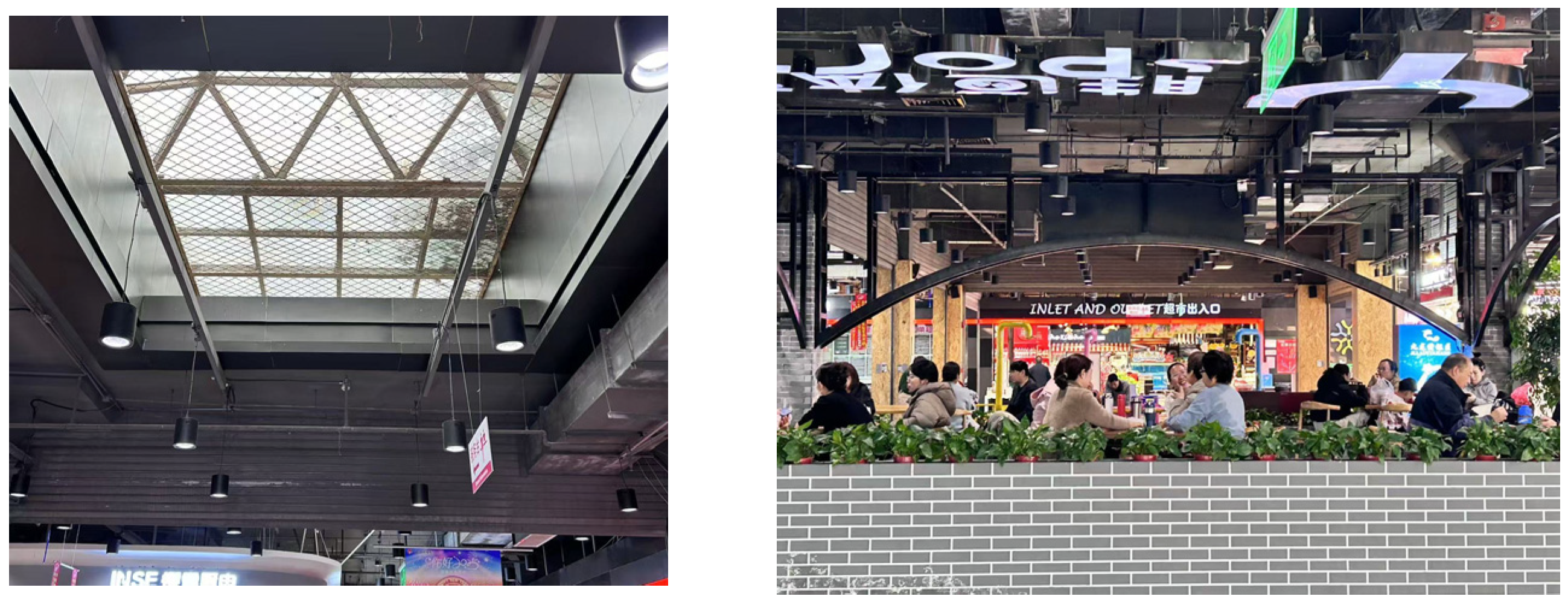
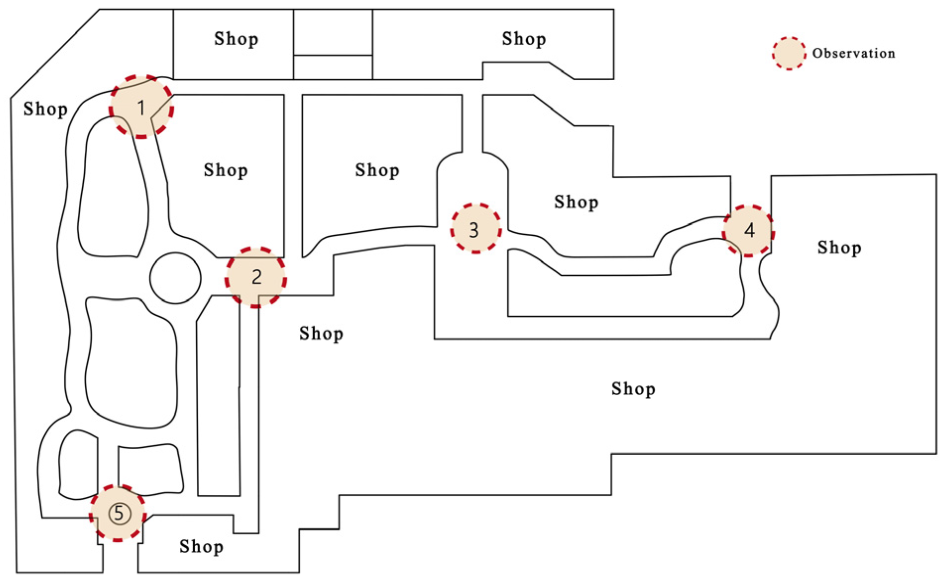
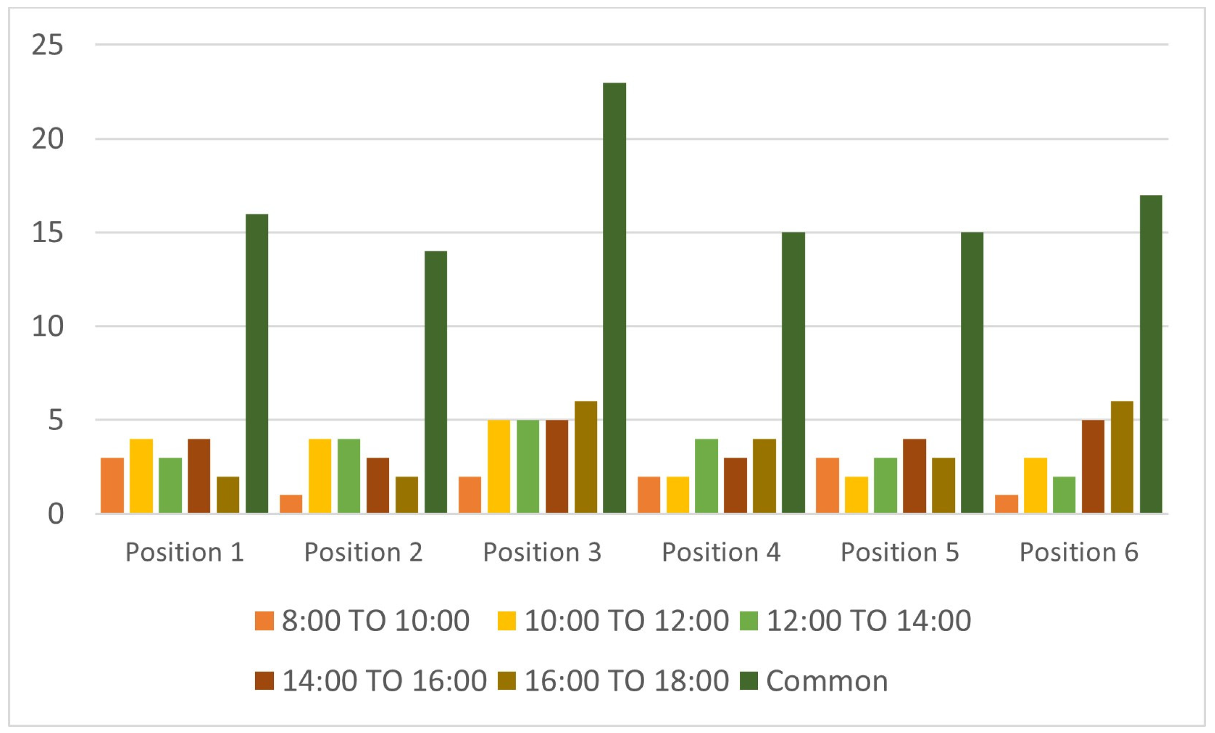
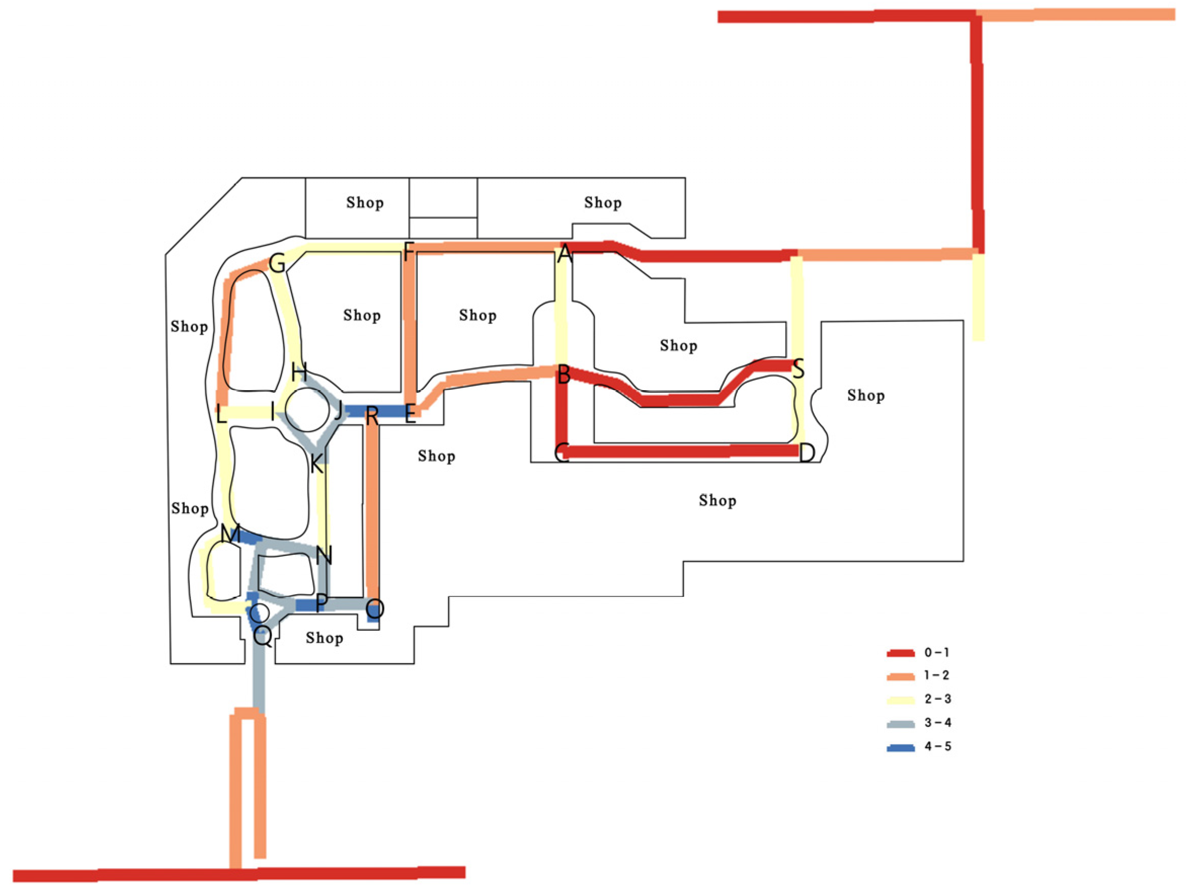
2.2.1. Determination of Observation Locations

To ensure the validity and scientific rigor of the research data, this study employs space syntax, specifically within the framework of visual field (isovist) analysis, to determine the optimal locations for observation points. Space syntax is a methodological approach grounded in geometric topology theory, used to analyze the spatial configuration of environments. It interprets complex spatial relationships by segmenting space into hierarchical scales or spatial divisions, thereby offering a systematic and scientifically grounded basis for spatial analysis.
Isovist analysis, as illustrated in Figure 5, is utilized to assess the visible area from a given perception point. This method enables the quantification of visual exposure and spatial openness, which are critical in understanding pedestrian perception and behavior in underground environments.
As illustrated in Figure 5, the darkest and lightest areas correspond to the maximum and minimum values of the visual field, respectively. These extremities typically indicate critical spatial nodes, such as turning points or intersections, which are often areas of pedestrian convergence. Therefore, observation points are conventionally positioned at locations with both the highest and lowest field-of-view values to capture a comprehensive range of spatial experiences.
In this study, a total of five observation points were selected based on the results of the visual field analysis (see Figure 6) to ensure representativeness and analytical depth.

2.2.2. Observation Methods

To ensure a statistically significant pedestrian volume baseline, the experimental observations were systematically conducted during five critical time intervals (8:00–10:00, 10:00–12:00, 12:00–14:00, 14:00–16:00, and 16:00–18:00) on both weekdays and weekends, with detailed recording of pedestrian activities. The collected data from corresponding time slots across two consecutive days were averaged to enhance the comprehensiveness of the dataset. Five dedicated observation teams simultaneously monitored five strategically located measurement points to maintain consistency in data collection. Pedestrian behavior was systematically documented at 15 min intervals, with transient interactions (defined as dwell time ≤ 10 s) being excluded from the final analysis to ensure data quality.
The measured data were imported into SPSS 26.0 for analysis to ensure data reliability. As presented in Table 1 and Table 2, the reliability and validity analysis demonstrated a Cronbach alpha coefficient of 0.71, which exceeded the minimum threshold of 0.70, indicating satisfactory data reliability. As shown in Figure 7, within the observation period, the number of pedestrians across each dwell time at each observation point during the day was 16, 14, 23, 15, 15, and 17, respectively. The pedestrian aggregation levels at the observation points, ranked from high to low, are as follows: Observation Point 3 > Observation Point 6 > Observation Point 1 > Observation Point 4 = Observation Point 5 > Observation Point 2.
As shown in Figure 8, the green area represents the location of the existing skylight (atrium) arrangement. However, observational data indicate that the level of pedestrian concentration in this area—specifically at Observation Point 2—is relatively low. Pedestrian density is influenced by multiple factors, including functional programming, spatial configuration, and the presence of specific activities.
This study focuses on pedestrian behavioral patterns guided by the underlying spatial road network structure, using this as a basis for proposing spatial modifications aimed at improving overall spatial quality. Data analysis reveals a mismatch between the current atrium location and actual pedestrian gathering zones within the Longhu Underground Pedestrian Street. The spatial value of the atrium can only be fully realized when its placement aligns with areas of high pedestrian activity. Such alignment enhances user experience and significantly boosts spatial vitality. Following the same methodology, measurements were conducted on other underground commercial streets with atrium spaces in Handan, yielding largely consistent results in the obtained data. (See Table 3 for other sample names.)
Therefore, during the early design stages or renovation processes of underground commercial streets, simulation tools should be employed to identify potential pedestrian gathering points. This approach can greatly enhance both the efficiency and quality of spatial design.

2.3. Analysis of sDNA-Based Technologies

Based on a review of existing literature, no prior studies have been identified that utilize spatial design network analysis (sDNA) technology to evaluate the rationality of atrium space layout within underground pedestrian streets. To address this research gap and further validate the hypothesized irrationality of the current atrium configuration in the Sunshine Longhu Underground Pedestrian Street in Handan, this study adopts the sDNA model for a comprehensive quantitative spatial analysis.
The spatial design network analysis (sDNA) technique represents an advanced extension of spatial syntax theory, enabling a more comprehensive understanding of how spatial configurations influence human behavioral patterns through refined network-based analytical methods. Compared to traditional spatial syntax, sDNA offers distinct advantages in dynamic performance evaluation, supports a broader range of urban applications, and allows for tailored analytical outputs. These capabilities collectively provide a robust scientific foundation for optimizing spatial layouts and enhancing urban functionality and sustainability.
In measuring accessibility, sDNA adopts the concept of Centrality from the field of social network analysis by applying Closeness and Betweenness metrics to assess changes in the centrality of cyberspace. By applying the indicators of Closeness and Betweenness, sDNA assesses changes in the centrality of cyberspace.
C l o s e n e s s = n 1 i j d i j
Proximity reflects the average difficulty of a path to a destination within a given radius and is a direct indicator of the ability of a street segment to facilitate purposeful movement. In short, high proximity means better accessibility and potentially more efficient use of space.
B e t e e n n e s s x = y N z R y P z O D y , z , x
In Equation (1), OD (y, z, x) is 1:
y , z , x = 1 , i f   x   i s   o n   t h e   s h o r t e s t   p a t h   f r o m   y   t o   z 1 2 , i f   x = y z 1 2 , i f   x = z y 1 3 , i f   x = y = z 0 , o t h e r w i s e
Intermediation measures how often a street segment occurs in the shortest path connecting to other streets, reflecting its potential as a crossing. In short, streets with high intermediation are particularly critical to urban mobility.
Based on the sDNA metric, this paper focuses on the rationality of the spatial layout of the atrium of underground pedestrian streets. Therefore, the accessibility of pedestrians to each section of the road network is calculated, and each section of the road is searched with a periphery of 50m, and the mean value of the penetration degree of all the paths in the planar model, NQPDA(x), is attached to each section of the road network. The calculation formula is as follows:
N Q P D A x = y r x p y d θ x , y
where p(y) is the weight of node y within the search radius r (which takes values from 0 to 1 in continuous space analysis).
The simulation process was conducted as follows: based on the layout of the underground pedestrian street at Sunny Dragon Lake, all road centerlines were extracted, with each line segmented at intersections to ensure accurate recognition of connectivity during the simulation. The processed data were then imported into the ArcGIS 10.8 platform. Considering that pedestrian path selection is influenced by multiple factors, a hybrid metric approach was employed. A search radius of 50 m was set, the obtained data were re-imported into the ArcGIS platform for further visualization processing of the MHD values, and the computed values for each road segment were classified into five levels using the natural breaks (Jenks) method (Figure 7), where deeper red indicates higher accessibility. To intuitively assess proximity values at road intersections, the segmented summation method was applied (Figure 8), with the calculation formula as follows:
Proximity at A = Section 1 + Section 2 + Section 3
As illustrated in Figure 8, the calculated proximity values for each road segment intersection reveal that the central area appears in the darkest shade, indicating high proximity, strong accessibility, and a significant concentration of pedestrian activity. In contrast, the lower-left portion of the network is shaded blue, signifying low proximity and correspondingly sparse pedestrian presence (Figure 9, Figure 10 and Figure 11). Based on the results from Equation (5), the point with the highest proximity is Point B, with a value of 17, whereas Point R registers the lowest value of 4. Additional proximity values for other nodes are detailed in Table 3.
Comparative analysis between empirical field measurements and computational simulation outputs revealed distinct spatial correlations: Observation Point 1 exhibited geometric correspondence with Simulation Point G, Observation Point 3 aligned with Simulation Point B, and Observation Point 6 demonstrated convergence characteristics with a composite of Simulation Points H, I, J, and K (designated as the mixed point). The closeness centrality metrics of Simulation Points G, B, and the mixed point maintained consistent ordinal rankings across all simulated nodes, closely mirroring the hierarchy observed at Observation Points 1, 3, and 6. Significantly, the analysis identified that the existing atrium space at Point E in Longhu Underground Pedestrian Street yielded a suboptimal closeness value of only 9, suggesting the need for spatial prioritization at Points B, G, and the mixed point to enhance pedestrian flow efficiency. Furthermore, this study substantiates the efficacy of spatial design network analysis (sDNA) in evaluating pedestrian aggregation patterns, as visually corroborated in Figure 12. These findings provide a robust, data-driven framework for optimizing atrium placement, thereby improving spatial performance, enriching pedestrian experience, and revitalizing the underground-built environment.

3. Results

As a critical nodal space within underground pedestrian networks, the atrium plays a pivotal role in enhancing environmental quality by leveraging natural light and ventilation to improve the internal microclimate. Pedestrian movement and congregation patterns are inherently influenced by the configuration of the road network and spatial affordances, with areas of high pedestrian stop and gathering potential ideally aligning with atrium locations. The strategic integration of these two elements—pedestrian flow dynamics and atrium placement—is essential for optimizing spatial vitality and fostering a vibrant underground environment.

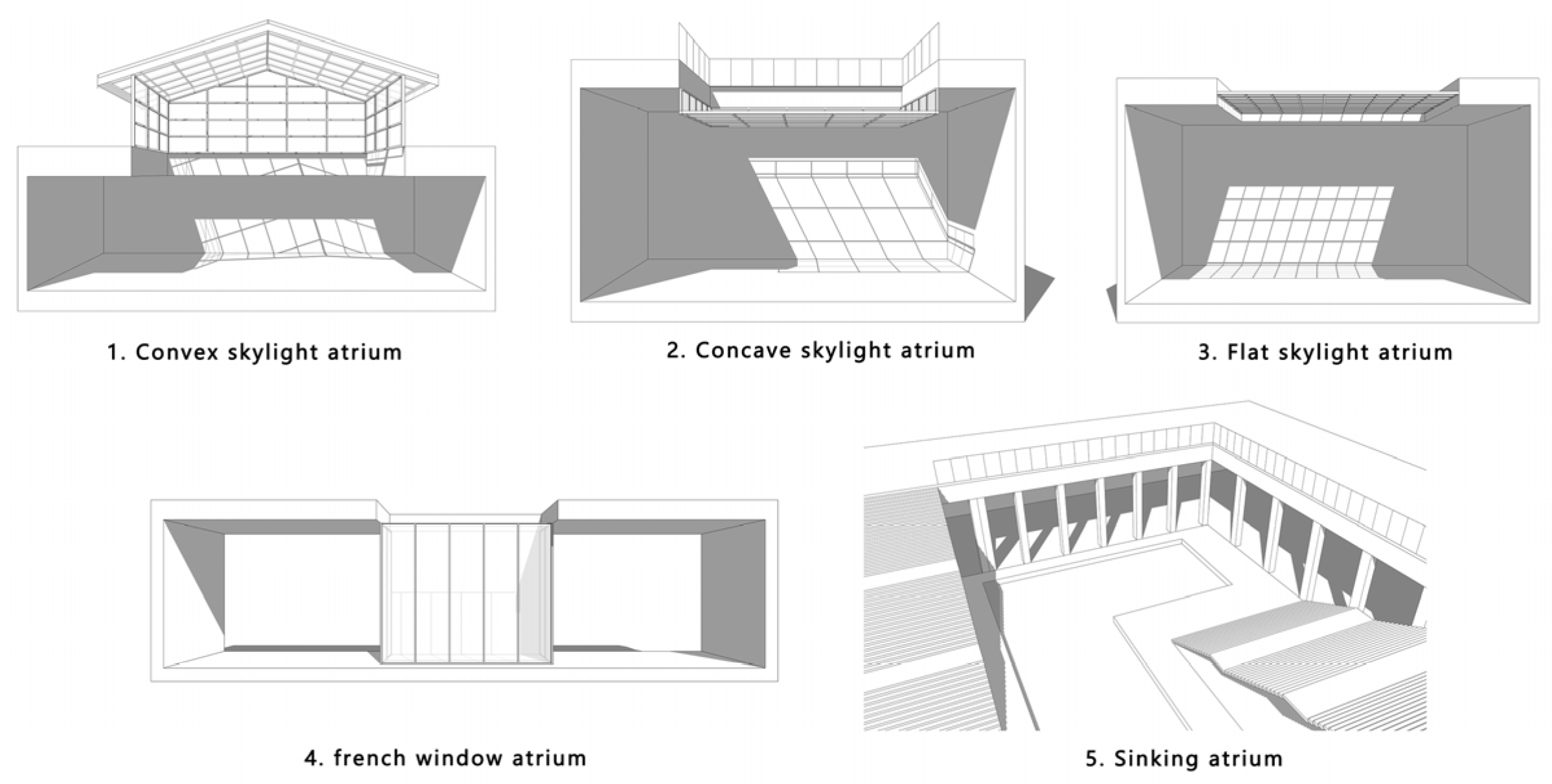
3.1. Atrium Space Repositioning

Field observation data and sDNA-based spatial network analysis reveal suboptimal positioning of existing atrium spaces in the underground pedestrian network. The current arrangement fails to align with natural pedestrian congregation patterns shaped by the road network morphology, resulting in inadequate spatial performance and diminished user experience. To address this inefficiency, a data-driven repositioning of atrium locations is proposed. Cross-validation between empirical observations and computational simulations identifies three high-aggregation nodes—directly influenced by the road network’s spatial configuration—as optimal candidates for atrium redistribution (Figure 13). These reconfigured points demonstrate strong spatial congruence with measured pedestrian density patterns, ensuring the redesigned atrium system effectively responds to actual movement behaviors while enhancing environmental quality and spatial vitality.

3.2. Internal Optimization of Atrium Space

(1)
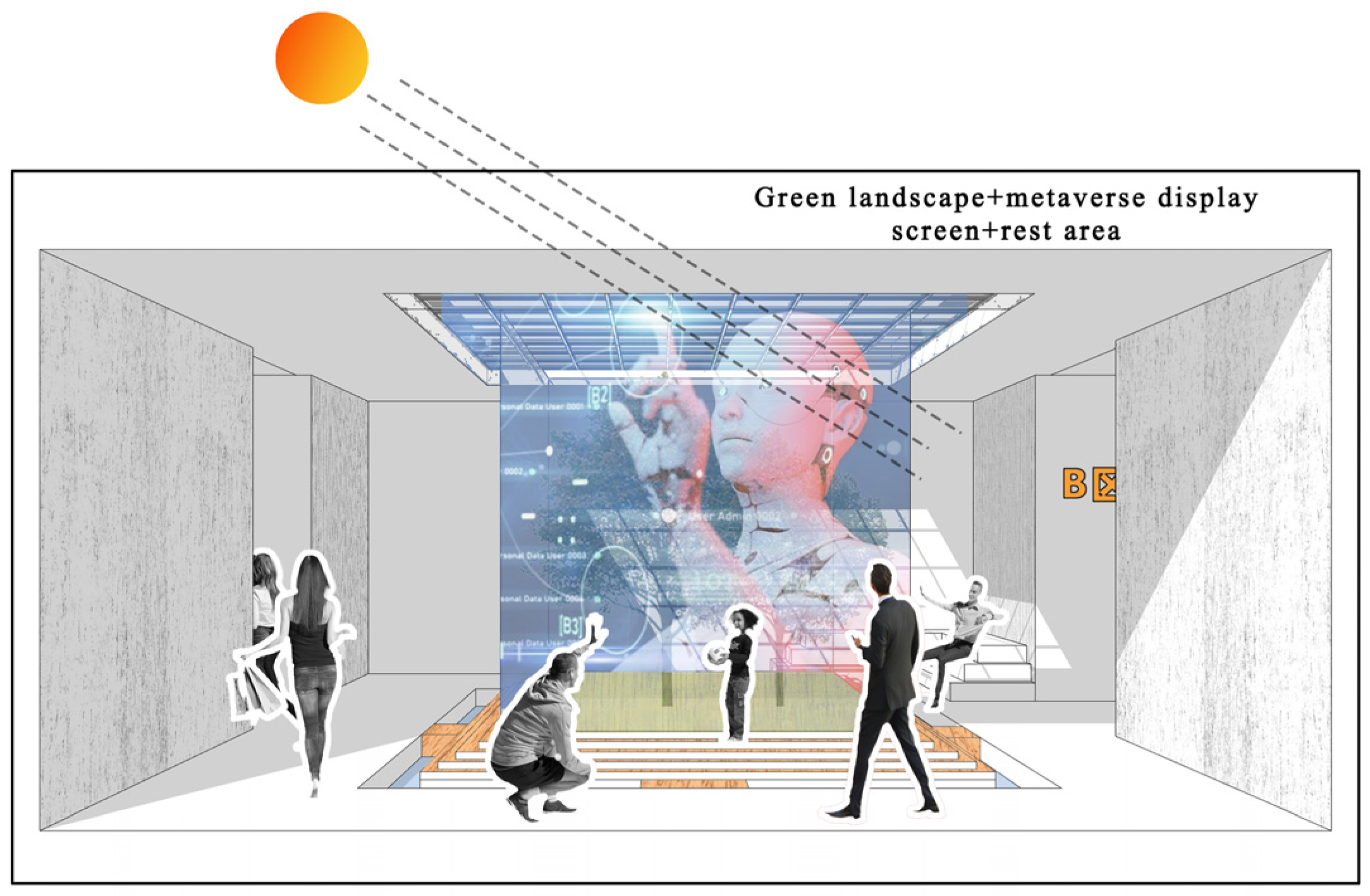
Innovative applications of meta-universe technology
The incorporation of metaverse technologies transforms atrium spaces into immersive virtual environments, significantly enhancing spatial interactivity and experiential quality to prolong pedestrian engagement and optimize agglomeration efficiency. Through the strategic deployment of Augmented Reality (AR) and Virtual Reality (VR) interfaces within these spaces, users can dynamically interact with digitally augmented physical elements, creating a hybrid reality that merges tangible and virtual dimensions. For instance, virtual exhibitions and interactive narrative installations can transport pedestrians into alternative environments, fostering a seamless convergence of real and digital realms. Furthermore, leveraging metaverse platforms enables the underground atrium to establish global connectivity, transcending geographical constraints to facilitate remote communication and collaboration. This technological integration redefines the atrium’s role—evolving it from a purely physical architectural element into a multidimensional nexus that bridges physical and digital worlds, thereby fostering innovative social interaction paradigms and expanding opportunities for cross-cultural exchange.
(2)
Functional diversity
The integration of adaptable architectural elements—such as movable partition walls and transformable furniture systems—enables dynamic spatial reconfiguration to accommodate diverse functional requirements, ranging from exhibitions and leisure activities to conference settings. Multi-functional furnishings, designed to serve dual purposes such as integrated seating-storage units, significantly enhance spatial efficiency. Complementing these features, intelligent environmental control systems automatically adjust lighting and acoustics to align with specific event atmospheres, while meticulous spatial planning ensures uninterrupted accessibility and visual comfort during functional transitions. This holistic approach to adaptive design transforms the ground floor atrium into a highly versatile environment capable of seamlessly supporting a broad spectrum of activities.
(3)
Eco-friendly spatial optimization
The integration of sustainable design principles and biophilic elements significantly reduces environmental impact while enhancing natural ambience within the space. Strategically positioned skylights and transparent building envelopes optimize daylight penetration, simultaneously decreasing reliance on artificial lighting and supporting photosynthetic requirements for interior vegetation. The implementation of living walls and vertical garden systems serves multiple ecological functions: improving indoor air quality through phytoremediation, enhancing biodiversity, and creating restorative environments for occupants. Furthermore, a comprehensive rainwater harvesting and reuse system demonstrates water conservation efficiency by supplying irrigation for interior landscaping and meeting non-potable water demands. As illustrated in Figure 14, this ecologically optimized underground atrium design achieves dual objectives: substantial energy conservation through passive environmental strategies and the creation of an invigorating, user-centered microclimate that fosters wellbeing.

4. Discussion and Prospect

Atrium space is one of the important node spaces directly connected with the external spatial environment in underground pedestrian streets, and its reasonable point arrangement has an obvious influence on the overall spatial quality of underground pedestrian streets. At present, most of the atrium spaces in underground pedestrian streets are set up by subjective feeling only and lack an objective basis. Therefore, from the perspective of pedestrian behavior, the article adopts a combination of on-site measurement and simulation and uses sDNA technology to find a reasonable layout of atrium space that matches pedestrian behavior.
At the same time, for the first time, this article applies sDNA technology to the study of spatial vitality in underground pedestrian streets, and through the conclusions, it can be seen that the technology can accurately verify the pedestrian aggregation behavior in pedestrian streets and combine with the reasonable layout of atrium space. This has certain reference significance for the future research of high-quality environment enhancement in underground space. Future research trajectories should address the following: multi-physics coupling effects of atrium placement on thermal-airflow environments; blockchain-enabled participatory design mechanisms for metaverse spaces; and machine learning-driven adaptability in hybrid physical-virtual spatial systems.

5. Conclusions

This investigation employs an integrated methodology combining field measurements and computational simulations to evaluate the spatial rationality of atrium placement in underground pedestrian systems, with a focused case study on Longhu Underground Pedestrian Street in Handan. The principal findings demonstrate the following:
Spatial network analysis integrated with sDNA (spatial design network analysis) techniques enables precise quantification of spatial proximity metrics (closeness centrality range: 0.42–0.78), effectively identifying optimal atrium locations that synergize pedestrian circulation patterns with spatial configuration. Metaverse-driven parametric reconstruction of atrium elements enhances user-centered spatial performance. The proposed hybrid framework demonstrates strong predictive capability. The methodology advances current practice through three key innovations: a topology-sensitive evaluation matrix reconciling space syntax principles with pedestrian trajectory analytics; a metaverse-augmented workflow for real-time user experience optimization; and a probabilistic model linking spatial configuration parameters to commercial vitality indicators. Implementation outcomes in the case study site reveal measurable benefits, as follows: a reduction in pedestrian-route deviations through atrium repositioning and an increase in dwell time density within optimized zones.
These approaches establish a replicable paradigm for revitalizing underground-built heritage. Moreover, for similar studies, spatial social network analysis provides a more scientific approach to assessing the rationality of atrium space positioning. The quantitative decision support framework offers municipal planners and urban designers actionable insights for evidence-based spatial retrofitting.
(Source of figures and tables: Figure 3 is from the Internet, all other images are from the author’s own photography and self-painting).

Author Contributions

Methodology, Y.H.; software, Y.H.; investigation, X.C.; writing—review and editing, Y.H., M.T., X.C., C.Z. and J.K. All authors have read and agreed to the published version of the manuscript.

Funding

This research was funded by the Hebei Culture and Art Science Planning and Tourism Research Project (No. HB22-YB113).

Institutional Review Board Statement

Not applicable.

Informed Consent Statement

Not applicable.

Data Availability Statement

No new data were created or analyzed in this study. Data are contained within the article.

Conflicts of Interest

The authors declare no conflicts of interest.

References

  1. Langenheim, N.; White, M.; Tapper, N.; Livesley, S.J.; Ramirez-Lovering, D. Right tree, right place, right time: A visual-functional design approach to select and place trees for optimal shade benefit to commuting pedestrians. Sustain. Sustain. Cities Soc. 2020, 52, 101816. [Google Scholar] [CrossRef]
  2. Cheng, K.Y.; Lau, K.; Shek, Y.T.; Liu, Z.; Ng, E. Evaluation on the performance of tree view factor in a high-density subtropical city: A case study in Hong Kong. Build. Environ. 2023, 239, 110431. [Google Scholar] [CrossRef]
  3. Sun, C.; Lian, W.; Liu, L.; Dong, Q.; Han, Y. The impact of street geometry on outdoor thermal comfort within three different urban forms in severe cold region of China. Build. Environ. 2022, 222, 109342. [Google Scholar] [CrossRef]
  4. Chen, T.; Yang, H.; Chen, G.; Lam, C.K.C.; Hang, J.; Wang, X.; Liu, Y.; Ling, H. Integrated impacts of tree planting and aspect ratios on thermal environment in street canyons by scaled outdoor experiments. Sci. Total Environ. 2021, 764, 142920. [Google Scholar] [CrossRef]
  5. Lee, H.; Mayer, H.; Kuttler, W. Impact of the spacing between tree crowns on the mitigation of daytime heat stress for pedestrians inside EW urban street canyons under Central European conditions. Urban For. Urban Green. 2020, 48, 126558. [Google Scholar] [CrossRef]
  6. An, L.; Hong, B.; Cui, X.; Geng, Y.; Ma, X. Outdoor thermal comfort during winter in China’s cold regions: A comparative study. Sci. Total Environ. 2021, 768, 144464. [Google Scholar] [CrossRef]
  7. Wang, K.; Li, Y.; Luo, Z.; Yin, S.; Chan, P.W. Harmonic analysis of 130-year hourly air temperature in Hong Kong: Detecting urban warming from the perspective of annual and daily cycles. Clim. Dyn. 2018, 51, 613–625. [Google Scholar] [CrossRef]
  8. Fahed, J.; Kinab, E.; Ginestet, S.; Adolphe, L. Impact of urban heat island mitigation measures on microclimate and pedestrian comfort in a dense urban district of Lebanon. Sustain. Cities Soc. 2020, 61, 102375. [Google Scholar] [CrossRef]
  9. Chen, H.; Zhao, L.; Cheng, L.; Zhang, Y.; Wang, H.; Gu, K.; Bao, J.; Yang, J.; Liu, Z.; Huang, J.; et al. Projections of heatwaveattributable mortality under climate change and future population scenarios in China. Lancet Reg. Health–West. Pac. 2022, 28, 100582. [Google Scholar]
  10. Wu, P.; Zhou, J.; Li, N. Influences of atrium geometry on the lighting and thermal environments in summer: CFD simulation based on-site measurements for validation. Build. Environ. 2021, 197, 107853. [Google Scholar] [CrossRef]
  11. Fan, M. Research on the Optimisation of Atrium Space in Hot Summer and Cold Winter Areas Based on the Contribution of Light and Heat Environment. Master’s Thesis, Wuhan University of Science and Technology, Wuhan, China, 2023. [Google Scholar]
  12. Zheng, X.; Chen, L.; Yang, J. Simulation framework for early design guidance of urban streets to improve outdoor thermal comfort and building energy efficiency in summer. Build. Environ. 2023, 228, 109815. [Google Scholar] [CrossRef]
  13. Achour-Younsi, S.; Fakher, K. Outdoor thermal comfort: Impact of the geometry of an urban street canyon in a Mediterranean subtropical climate—Case study Tunis, Tunisia. Procedia—Soc. Behav. Sci. 2016, 216, 689–700. [Google Scholar] [CrossRef]
  14. Wang, X. Research on the Influence of Atrium on Wayfinding Experience in Commercial Complexes. Master’s Thesis, Huazhong University of Science and Technology, Wuhan, China, 2022. [Google Scholar]
  15. Loures, L.; Panagopoulos, T.; Burley, J.B. Assessing User Preferences on Post-Industrial Redevelopment. Environ. Environ. Plan. B Plan. Des. 2016, 43, 871–892. [Google Scholar] [CrossRef]
  16. Li, S.; Wang, H.; Chen, G. Research on the Improving Strategies for the Revitalization of Industrial Heritage Based on POE: A Case Study of Taikoo Warehouse in Guangzhou. Zhuangshi 2023, 66, 130–132. [Google Scholar]
  17. Liu, B. Research on the Optimal Design of Natural Ventilation in University Gymnasiums in Xi’an. Master’s Thesis, Xi’an University of Architecture and Technology, Xi’an, China, 2023. [Google Scholar]
  18. Lam, C.K.C.; Gallant, A.J.E.; Tapper, N.J. Does irrigation cooling effect intensify during heatwaves. A case study in the Melbourne botanic gardens. Urban For. Urban Green. 2020, 55, 126815. [Google Scholar] [CrossRef]
  19. Fu, M.; Ban, K.; Jin, L.; Wu, D. How Urban Street Spatial Composition Affects Land Surface Temperature in Areas with Different Population Densities: A Case Study of Zhengzhou, China. Sustainability 2024, 16, 9938. [Google Scholar] [CrossRef]
  20. Li, W. Research on the Renewal Design of Park Space Based on Post-Occupancy Evaluation—Taking Santaishan Park in Kunming as an Example. Design 2023, 8, 3203–3211. [Google Scholar] [CrossRef]
  21. Galal, K.S. The impact of atrium top materials on daylight distribution and heat gain in the Lebanese coastal zone. Alex. Eng. J. 2019, 58, 659–676. [Google Scholar] [CrossRef]
  22. Liang, Y. Research on Natural Light Introduction and Skylight Design Strategies for Underground Pedestrian Spaces Based on Visual Comfort. Master’s Thesis, China University of Mining and Technology, Xuzhou, China, 2022. [Google Scholar]
  23. Wang, H.-R.; Dong, W.-L.; Liang, D. Performance-based Design of Smoke Control and Evacuation in a Building Atrium. Procedia Eng. 2011, 11, 431–436. [Google Scholar]
  24. Naeemaee, R.; Gül, Z.S. Assessment of acoustical comfort in educational atriums of closed central and linear typologies: Reverberation perception and preference. Build. Environ. 2024, 252, 111230. [Google Scholar] [CrossRef]
  25. Dong, L.; He, Y.; Qi, Q.; Wang, W. Optimization of daylight in atrium in underground commercial spaces: A case study in Chongqing, China. Energy Build. 2022, 256, 111739. [Google Scholar] [CrossRef]
  26. Shi, X. Research on Shape Optimization Design of Underground Courtyards in Cold Regions Based on Climate Adaptation. Master’s Thesis, China University of Mining and Technology, Xuzhou, China, 2023. [Google Scholar]
  27. Xue, C. Research on the Optimization of Thermal Environment in Underground Courtyards of Commercial Buildings. Master’s Thesis, China University of Mining and Technology, Xuzhou, China, 2021. [Google Scholar]
  28. Carli, R.; Dotoli, M.; Pellegrino, R.; Ranieri, L. Using multi-objective optimization for the integrated energy efficiency improvement of a smart city public buildings’ portfolio. In Proceedings of the 2015 IEEE International Conference on Automation Science and Engineering (CASE), Gothenburg, Sweden, 24–28 August 2015. [Google Scholar]
  29. Pourzeynali, S.; Zarif, M. Multi-objective optimization of seismically isolated high-rise building structures using genetic algorithms. J. Sound Vib. 2008, 311, 1141–1160. [Google Scholar] [CrossRef]
  30. Lozano, M.A.; Ramos, J.C.; Carvalho, M.; Serra, L.M. Structure optimization of energy supply systems in tertiary sector buildings. Energy Build. 2009, 41, 1063–1075. [Google Scholar] [CrossRef]
  31. Albuquerque, D.P.; Mateus, N.; Avantaggiato, M.; da Graça, G.C. Full-scale measurement and validated simulation of cooling load reduction due to nighttime natural ventilation of a large atrium. Energy Build. 2020, 224, 110233. [Google Scholar] [CrossRef]
  32. Wu, S.-H. Research on the Design Strategy of Core Shared Atrium of Central Metro Station Complex. Master’s Thesis, South China University of Technology, Guangzhou, China, 2023. [Google Scholar]
  33. Ru, S. Research on Underground Atrium of Commercial Buildings Based on Thermal Comfort. Master’s Thesis, China University of Mining and Technology, Xuzhou, China, 2021. [Google Scholar]
  34. Yue, Q.; Chen, J.; Huo, S. Discussion on the construction of atrium lighting in high space of public buildings. Light Source Light. 2023. [Google Scholar]
  35. Li, J. Research on Environmental Comfort of Underground Public Space of Transport Complex Based on Simulation. Master’s Thesis, North University of Technology, Beijing, China, 2023. [Google Scholar]
  36. Liu, W. Optimisation of Natural Lighting in Core Commercial Atriums in Jinan Based on Parametric Design. Master’s Thesis, Shandong University of Architecture, Jinan, China, 2023. [Google Scholar]
  37. Liu, T. Discussion on Outdoor Public Space Design of Urban Commercial Complex. Master’s Thesis, Nanchang University, Nanchang, China, 2023. [Google Scholar]
  38. Ran, P. Natural smoke exhaust effectiveness hot smoke test for underground large space pedestrian street fires. Fire Sci. Technol. 2020, 39, 772–774+777. [Google Scholar]
  39. Jiang, Y. Research on the Development and Utilisation of Underground Space along Hongkong Middle Road in Qingdao Main City. Master’s Thesis, Qingdao University of Technology, Qingdao, China, 2018. [Google Scholar]
  40. Chan, I.Y.S.; Dong, Z.; Chen, H. Impacts of connections to the outside on underground space occupants’ psychophysiological health: A virtual reality-based experimental approach. Tunn. Undergr. Space Technol. 2024, 147, 105675. [Google Scholar] [CrossRef]
  41. Li, X.; Wang, C.; Kassem, M.A.; Ali, K.N. Emergency evacuation of urban underground commercial street based on BIM approach. Ain Shams Eng. J. 2024, 15, 102633. [Google Scholar] [CrossRef]
  42. Yu, J.-R. Research on Humanised Design of Public Space in Urban Commercial Pedestrian Street. Master’s Thesis, South China University of Technology, Guangzhou, China, 2017. [Google Scholar]
  43. He, C. Research on Three-Dimensional Design of Outdoor Open Space of Shenzhen Urban Complex. Master’s Thesis, South China University of Technology, Guangzhou, China, 2022. [Google Scholar]
  44. Lu, Y. Research on Public Transportation Space of Underground Commercial Buildings. Master’s Thesis, Dalian University of Technology, Dalian, China, 2003. [Google Scholar]
  45. Mu, B.; Liu, C.; Mu, T.; Xu, X.; Tian, G.; Zhang, Y.; Kim, G. Spatiotemporal fluctuations in urban park spatial vitality determined by on-site observation and behavior mapping: A case study of three parks in Zhengzhou City, China. Urban For. Urban Green. 2021, 64, 127246. [Google Scholar] [CrossRef]
  46. Kim, Y.L. Seoul’s Wi-Fi hotspots: Wi-Fi access points as an indicator of urban vitality. Comput. Environ. Urban Syst. 2018, 72, 13–24. [Google Scholar] [CrossRef]
  47. Zheng, J.; He, J.; Tang, H. The vitality of public space and the effects of environmental factors in Chinese suburban rural communities based on tourists and residents. Int. J. Environ. Res. Public Health 2022, 20, 263. [Google Scholar] [CrossRef] [PubMed]
  48. Ren, Z.; Zhao, H.; Fu, Y.; Xiao, L.; Dong, Y. Effects of urban street trees on human thermal comfort and physiological indices: A case study in Changchun city, China. J. For. Res. 2022, 33, 911–922. [Google Scholar] [CrossRef]
  49. Niu, T.; Qing, L.; Han, L.; Long, Y.; Hou, J.; Li, L.; Tang, W.; Teng, Q. Small public space vitality analysis and evaluation based on human trajectory modeling using video data. Build. Environ. 2022, 225, 109563. [Google Scholar] [CrossRef]
  50. Weilnhammer, V.; Schmid, J.; Mittermeier, I.; Schreiber, F.; Jiang, L.; Pastuhovic, V.; Herr, C.; Heinze, S. Extreme weather events in europe and their health consequences—A systematic review. Int. J. Hyg. Environ. Health 2021, 233, 113688. [Google Scholar] [CrossRef]
  51. Zhang, Y.; Zheng, Z.; Zhang, S.; Fang, Z.; Lin, Z. Exploring thermal comfort and pleasure in outdoor shaded spaces: Inspiration for improving thermal index models. Build. Environ. 2024, 265, 111933. [Google Scholar] [CrossRef]
  52. Ceccarelli, G.; Messa, F.; Gorrini, A.; Presicce, D.; Choubassi, R. Deep learning video analytics for the assessment of street experiments: The case of bologna. J. Urban Mobil. 2023, 4, 100067. [Google Scholar] [CrossRef]
  53. Liu, R.; Jiao, L.; Liu, Y.; Wang, Y. Multi-scale spatial analysis of satellite-retrieved surface evapotranspiration in Beijing, a rapidly urbanizing region under continental monsoon climate. Environ. Sci. Pollut. Res. 2023, 30, 20402–20414. [Google Scholar] [CrossRef]
  54. Huang, J.; Shen, S.; Zhao, M.; Cheng, C. Assessment of Summer Regional Outdoor Heat Stress and Regional Comfort in the Beijing-Tianjin-Hebei Agglomeration Over the Last 40 Years. GeoHealth 2023, 7, e2022GH000725. [Google Scholar] [CrossRef]
  55. Bai, M.; Hu, R.; Lian, H.; Zhou, W. Correlation Study of Commercial Street Morphology and Pedestrian Activity in Cold Region Summers under Thermal Comfort Guidance: A Case Study of Sanlitun, Beijing. Buildings 2024, 14, 1751. [Google Scholar] [CrossRef]
  56. Arsad, F.S.; Hod, R.; Ahmad, N.; Baharom, M.; Ja’afar, M.H. Assessment of indoor thermal comfort temperature and related behavioural adaptations: A systematic review. Environ. Sci. Pollut. Res. 2023, 30, 73137–73149. [Google Scholar] [CrossRef]
  57. Yue, H. Investigating the influence of streetscape environmental characteristics on pedestrian crashes at intersections using street view images and explainable machine learning. Accid. Anal. Prev. 2024, 205, 107693. [Google Scholar] [CrossRef] [PubMed]
  58. Zhang, Y.; Du, X.; Shi, Y. Effects of street canyon design on pedestrian thermal comfort in the hot-humid area of China. Int. J. Biometeorol. 2017, 61, 1421–1432. [Google Scholar] [CrossRef] [PubMed]
  59. Nasrollahi, N.; Namazi, Y.; Taleghani, M. The effect of urban shading and canyon geometry on outdoor thermal comfort in hot climates: A case study of Ahvaz, Iran. Sustain. Cities Soc. 2021, 65, 102638. [Google Scholar] [CrossRef]
  60. Zhang, J.; Zhou, W.; Lian, H.; Hu, R. Research on Optimization Strategy of Commercial Street Spatial Vitality Based on Pedestrian Trajectories. Buildings 2024, 14, 1240. [Google Scholar] [CrossRef]
  61. Perini, K.; Magliocco, A. Effects of vegetation, urban density, building height, and atmospheric conditions on local temperatures and thermal comfort. Urban For. Urban Green. 2014, 13, 495–506. [Google Scholar] [CrossRef]
  62. Cao, A.; Li, Q.; Meng, Q. Effects of orientation of urban roads on the local thermal environment in Guangzhou City. Proc. Eng. 2015, 121, 2075–2082. [Google Scholar] [CrossRef]
  63. Watanabe, S.; Nagano, K.; Ishii, J.; Horikoshi, T. Evaluation of outdoor thermal comfort in sunlight, building shade, and pergola shade during summer in a humid subtropical region. Build. Environ. 2014, 82, 556–565. [Google Scholar] [CrossRef]
  64. Correa, E.; Ruiz, M.A.; Canton, A.; Lesino, G. Thermal comfort in forested urban canyons of low building density. An assessment for the city of Mendoza, Argentina. Build. Environ. 2012, 58, 219–230. [Google Scholar] [CrossRef]
Figure 1. Actual photo of the existing atrium space.
Buildings 15 01549 g001
Figure 2. Excellent domestic and international cases.
Buildings 15 01549 g002
Figure 3. Excellent domestic and international cases. Chart source: https://www.gooood.cn/ (Accessed on 21 December 2024).
Buildings 15 01549 g003
Figure 4. Type of atrium in an underground pedestrian street.
Buildings 15 01549 g004
Figure 5. Viewshed analysis.
Buildings 15 01549 g005
Figure 6. Layout of observation points.
Buildings 15 01549 g006
Figure 7. Number of people staying at the observation point.
Buildings 15 01549 g007
Figure 8. Behavior annotation diagram and existing atrium location.
Buildings 15 01549 g008
Figure 9. Analysis of sDNA proximity.
Buildings 15 01549 g009
Figure 10. Calculation diagram for intersection of road sections.
Buildings 15 01549 g010
Figure 11. Calculation of proximity values.
Buildings 15 01549 g011
Figure 12. Summary of Vitality Values by Corner.
Buildings 15 01549 g012
Figure 13. Optimized distribution points in the atrium.
Buildings 15 01549 g013
Figure 14. Schematic diagram of atrium renovation (point B space).
Buildings 15 01549 g014
Table 1. Results of confidence analysis.
Reliability Statistics
AlphaNumber of items
0.71030
Table 2. Results of validity analysis.
KMO and Bartlett Inspection
KMO sampling suitability quantity.0.751
Bartlett sphericity testApproximate chi square540.563
Freedom91
Significance0.000
Table 3. Summary of the study sample.
Supplementary Samples
1. Diyi Avenue Underground Commercial Street
2. Underground commercial street of Xingang Shopping Plaza
3. Zhaodu New City Underground Commercial Street
Disclaimer/Publisher’s Note: The statements, opinions and data contained in all publications are solely those of the individual author(s) and contributor(s) and not of MDPI and/or the editor(s). MDPI and/or the editor(s) disclaim responsibility for any injury to people or property resulting from any ideas, methods, instructions or products referred to in the content.

