Article

Spatial and Temporal Distribution Characteristics of Heritage Buildings in Yangzhou and Influencing Factors and Tourism Development Strategies

1
School of Design, Jiangnan University, Wuxi 214122, China
2
College of Fine Arts, Sichuan University of Science and Engineering, Zigong 643000, China
3
School of Art Design And Media, East China University of Science and Technology, Shanghai 200237, China
*
Author to whom correspondence should be addressed.
Buildings 2025, 15(7), 1081; https://doi.org/10.3390/buildings15071081
Submission received: 18 February 2025 / Revised: 23 March 2025 / Accepted: 25 March 2025 / Published: 27 March 2025
(This article belongs to the Section Architectural Design, Urban Science, and Real Estate)

Abstract

Heritage buildings are significant humanistic tourism resources for a city. Yangzhou’s heritage buildings have conservation and utilization value and are a key vehicle for promoting urban tourism development. However, there is a lack of research on their spatiotemporal distribution characteristics and subdivision types. This study aims to explore the spatial and temporal clustering and distribution characteristics of Yangzhou’s heritage buildings, as well as the factors contributing to the formation of these distribution patterns, as a means of promoting the tourism development of Yangzhou. Using mathematical statistics and GIS spatial analysis methods, this study analyzes the geographical distribution patterns of 528 heritage buildings and their influencing factors by using average nearest neighbor analysis, an imbalance index, and density mapping. This study reveals the following findings: (1) The temporal distribution shows an “Λ” shape, in which ancient buildings, modern historical sites, and important modern historical sites and representative buildings account for a significant proportion. (2) The temporal center shows a trend of shifting over time, moving from the southwest to the northwest and then to the northeast. (3) The spatial distribution is uneven; most of these are clustered in Hanjiang District, Gaoyou District, and Baoying County, while few are distributed in other regions. (4) The distribution is influenced by both natural and human factors, including topography, water resources, salt merchant culture, revolutionary culture, war culture, and canal transportation culture, with humans and human factors having a more profound impact than natural factors. Based on these findings, strategies such as regional integration and route planning, the prioritization of sustainable tourism development and preservation, and culture fusion and innovative promotion are proposed in this study as references for the all-for-one tourism development and cultural dissemination of Yangzhou.

1. Introduction

Heritage buildings, corresponding to legal provisions, are immovable cultural relics. They have high artistic aesthetic value, historical and cultural value, tourism value, and architectural technology reference value. According to the Law of the People’s Republic of China on the Protection of Cultural Relics (2008), heritage buildings include ancient sites, ancient tombs, ancient buildings, stone cave temple sites and stone carvings, important modern historical sites, and representative buildings [1]. China has abundant heritage buildings, with 766,722 immovable cultural relics registered during the third national cultural relic survey [2]. However, there is a lack of comprehensive understanding of the historical and cultural value of heritage buildings in China, because of differences in historical development stages and economic levels. The “ambiguity” of basic data, the “isolation” of preservation management, and the “polarization” of development and utilization have become challenges for the sustainable development of heritage buildings. These are critical problems that need to be addressed in the process of inheriting excellent traditional culture and building an advanced spatial governance system [3].
International research on heritage buildings started relatively early. The promulgation in 1931, the earliest guiding document on the preservation and renewal of historical heritage buildings, triggered public awareness of heritage buildings and preservation [4]. Subsequently, the promulgation of a series of charters, further standardized the concept and preservation methods of heritage buildings, thus promoting research in this field. Globally, research on heritage buildings has made substantial achievements, showing a trend of comprehensive and multi-disciplinary development. Current research has expanded from the single field of heritage buildings to cover heritage management, tourism development, social education, and other fields, encompassing disciplines such as economics, tourism science, urban planning, architecture, and education science. Mainstream research topics include fundamental theoretical research and technological innovation practices in heritage buildings, such as heritage building operation and management [5,6], sustainable tourism model innovation [7,8,9], heritage building education research [10], heritage building value and evaluation methods [11,12], digital modeling and monitoring [13,14], and restoration methods for heritage buildings [15,16]. Research objects have become increasingly diversified, encompassing residential buildings [17,18], public buildings [19], industrial buildings [20,21], and other types [22] of heritage buildings from different periods [23]. This trend reflects scholars’ deepening understanding of heritage building preservation and related research fields and reveals the complex relationships between buildings and human society and culture, the economy, and the environment. Research methods have evolved from traditional qualitative research to quantitative evaluations [5] and even digital technologies [13]. The development of modern GIS [24,25], 3D modeling [22,26], machine learning [27], and heritage building information modeling (HBIM) [28] has enriched the evaluation and preservation research of heritage buildings. On the one hand, these advancements enable precise mapping of physical attributes [26,29] and quantitative classification of heritage buildings [30], thus providing critical references for assessment [31,32,33]. On the other hand, digital technologies help explore the development strategies of creating virtual reality models [34] and the digital preservation [35,36] of heritage buildings. These technologies are evolving towards multi-technology collaboration [25,37], providing more diverse and precise technical guidance for the preservation and development of heritage buildings.
Overall, existing research has provided crucial theoretical and methodological support for the research of Chinese heritage buildings. Notably, current research primarily involves specific and narrowly scoped studies, focusing on individual buildings. Less attention is granted to broader perspectives, such as the distribution, historical evolution, and comprehensive planning of heritage buildings within urban areas. Under China’s all-for-one tourism policies (China’s all-for-one tourism policies: This is a new concept and mode of coordinated regional development, the core of which lies in taking tourism as the dominant industry, and through the all-round optimisation and upgrading of economic and social resources in the region, realising the organic integration of regional resources and the integrated development of industries, so as to drive and promote the coordinated development of the economy and society), more heritage buildings have been integrated into urban tourism planning and attracted growing public attention. Nevertheless, the correlation between the distribution characteristics of urban heritage buildings and the development of all-for-one tourism remains underexplored. The emergence of heritage buildings is influenced by various factors across different historical periods and geographic spaces, resulting in distinct distribution patterns that vary in both time and space. However, there is still limited research in this field, and the application of related findings in heritage building preservation and tourism development is also relatively scarce. By focusing on the spatial and temporal distribution changes of heritage buildings within urban areas and proposing urban tourism development strategies on this basis, it becomes possible to explore the trends of urban development in different historical periods, interpret the trajectory of local economic and social development, and understand spatial transformations. This is significant for constructing a historical and cultural spatial system that integrates regional diverse historical and cultural resources with supporting natural resources.
This study focuses on Yangzhou, which is in the first tier of China’s national historical and cultural cities. A total of 528 national-, provincial-, and municipal-level heritage buildings are selected as study objects. Using mathematical statistics and GIS 10.8 spatial analysis methods, temporal and spatial distribution characteristics, influencing factors, and the development of tourism routes are explored in this study. This study reveals the evolution process and driving mechanisms of the human–environment relationship system in Yangzhou. The results promote the integrated development of regional heritage resources and provide a reference for the census and inheritance of outstanding local culture.
This study has the following three primary objectives:
(1)
To reveal the temporal and spatial distribution characteristics of 528 heritage buildings in Yangzhou;
(2)
To analyze the factors influencing the distribution characteristics of heritage buildings in Yangzhou across different historical periods;
(3)
To propose a tourism route plan for heritage buildings in Yangzhou based on preliminary analysis.

2. Data Source and Methodology

2.1. Study Area and Data Source

Yangzhou is located at the intersection of the Yangtze River and the Grand Canal, in the central part of Jiangsu Province. The terrain within the city slopes from west to east, with hills in the northern part of the urban area and Yizheng City, the Lixiahe region to the east of the Grand Canal, and north of the Tongyang Canal. There are plains along the Yangtze River and lakes. The history of Yangzhou can be dated back to the Warring States period in 486 BC, spanning nearly 2500 years. The city has witnessed the confluence of various cultures, including canal culture, garden culture, and commercial culture, giving rise to numerous historical buildings [38]. A 5.09 km2 area of old towns from the Ming and Qing Dynasties, containing over 500 historical buildings and more than 400,000 m2 of traditional residences, has been preserved in Yangzhou, making it one of the best-preserved cities in China in terms of traditional architectural features and earning it a spot in the first tier of national historical and cultural cities in China. The study area covers the entire administrative region of Yangzhou (Figure 1), including three districts (Hanjiang District, Guangling District, and Jiangdu District), one county (Baoying County), and two county-level cities (Gaoyou and Yizheng) under the jurisdiction of Yangzhou. The study objects include 528 heritage buildings in Yangzhou, with data sourced from the National Cultural Heritage Administration, Jiangsu Provincial Department of Culture and Tourism, and Yangzhou Municipal Department of Culture and Tourism (https://wglj.yangzhou.gov.cn/zfxxgk/fdzdgknr/tjxx/art/2022/art_aa8934dd9cea4daca8f877d9611fb2e6.html (accessed on 19 March 2022)). As of June 2024, Yangzhou has 24 national-level heritage buildings, 50 provincial-level heritage buildings, and 454 city- and county-level heritage buildings.
The data were derived from publicly available resources provided by the Yangzhou Municipal Department of Culture and Tourism and supplemented by historical maps, local chronicles, and other related publications. The data include basic information such as the addresses, construction dates, and historical uses of the heritage buildings. The geographic coordinates of these heritage buildings were identified using the Baidu Maps API (https://api.map.baidu.com/lbsapi/cloud/index.htm) coordinate picker and further verified with Google Earth [39]. Administrative division data were collected from the 1:1,000,000-scale national geographic database of the National Geomatics Center of China. Digital elevation and hydrographic data were sourced from the Geospatial Data Cloud. After editing, correcting, and projection transformations, the data were used to generate a unified coordinate system and then imported into ArcGIS 10.8 software to create a database of heritage buildings in Yangzhou.

2.2. Methodology

A series of spatial and temporal analysis methods were employed in this study to analyze the spatial and temporal distribution characteristics of heritage buildings in Yangzhou. ArcGIS 10.8, supplemented by the nearest neighbor ratio, the C v coefficient of variation, and kernel density estimation methods, was used in the spatial analysis to analyze the spatial distribution characteristics of heritage buildings in Yangzhou. Overlay analysis and buffer zone analysis were conducted to explore the influencing factors of distribution.
The nearest neighbor ratio indicates the proximity of point features in geographic space, with its formula as follows:
R = r ¯ r i ¯
where r ¯ is the average observation distance, r i ¯ is the expected average distance, and R is the nearest neighbor ratio. R = 1 indicates the random spatial distribution of point features, R < 1 indicates the clustered distribution of point features, and R > 1 indicates the dispersed distribution of point features [40,41].
C v , the coefficient of variation, represents the spatial variation of point sets in a Voronoi diagram. If the point sets are evenly distributed, the variation of polygon areas in the Voronoi diagram is minimal, and C v is 29% (including values < 33%). If the point sets are randomly distributed, C v is 57% (including values within 33–64%). If the point sets are clustered, the variation in the polygon areas is large, and C v is 92% (including values > 64%).
Kernel density analysis was conducted to investigate the spatial variation in the density and distribution characteristics of points within the study area. The formula is as follows:
f n ( x ) = 1 n h i = 1 n k x x 1 h
where k (⋅) is the kernel function, h > 0 is the bandwidth, and x x 1 is the distance from the estimation point x to the target location. n is the number of points in the bandwidth range.

3. Temporal and Spatial Distribution Characteristics of Heritage Buildings in Yangzhou

3.1. Temporal Distribution Characteristics

3.1.1. Overall Temporal Pattern

Yangzhou has experienced a long history, with heritage buildings spanning a wide temporal range and distributed unevenly. Based on the timeline of Chinese history and considering the special characteristics of the formation and development of heritage buildings in Yangzhou, this study divides the construction periods of heritage buildings in Yangzhou into the following six periods (Figure 2): the period before the Sui and Tang Dynasties (approximately 1.7 million years ago–581 CE), the Sui–Tang Dynasty period (581–960 CE), the Song and Yuan dynasty period (960–1368 CE), the Ming and Qing Dynasty period (1368–1912 CE), the Republic of China period (1912–1949 CE), and the modern period (1949 CE–present). The frequency of the number of heritage buildings varies greatly across these historical periods, showing an “Λ-shaped” distribution pattern. In general, the number of heritage buildings in Yangzhou is closely tied to their preservation levels, following a pattern where older buildings are fewer and newer ones are more abundant. Most preserved heritage buildings were built in the Ming and Qing Dynasty and Republic of China periods, while few heritage buildings were constructed in the other four periods.
Based on the literature [42,43,44], the reasons for this can be attributed to the following. Most heritage buildings in Yangzhou were constructed with materials such as earth and wood. Over the long course of history, natural and human factors have made it increasingly difficult to preserve buildings from earlier periods. In contrast, buildings from more recent historical periods are better preserved due to shorter time spans since their construction. The existence and preservation of heritage buildings are intricately tied to the social stability, economic development, and cultural prosperity of the historical periods. Before the Qing Dynasty, Yangzhou was a military stronghold and was repeatedly subjected to city-wide massacres and reconstructions, resulting in a limited number of well-preserved heritage buildings [45]. For instance, during the Wei, Jin, and Southern and Northern Dynasty periods, frequent wars and social unrest led to the destruction of buildings and left residents in hardship. In contrast, during the Ming and Qing Dynasty period, Yangzhou experienced high levels of economic, technological, and cultural development, reaching its peak prosperity. This spurred the creation of a large number of historically significant heritage resources, resulting in a sharp increase in the number of heritage buildings from this period. However, during the Republic of China period, frequent wars once again caused the significant destruction of heritage buildings [46]. In the modern period, the number of heritage buildings is relatively small. This is partly due to the selection system for cultural heritage sites, which tends to prioritize older structures over more recent ones. This is a trend observed nationwide.

3.1.2. The Temporal Pattern of Types

In terms of types, the preserved cultural relic sites in Yangzhou can be categorized into five types based on the list of preserved cultural relic sites published by the state (Figure 3 and Table 1): ancient sites, ancient tombs, ancient buildings, stone cave temple sites and stone carvings, and modern and contemporary significant historical sites and representative buildings.
Heritage buildings in Yangzhou before the Sui and Tang Dynasties include two types: ancient sites and ancient tombs; these number 20 and 12, respectively. The number of heritage buildings marked decreased during the Sui and Tang Dynasty period, but the types increased. In this period, ancient sites, ancient tombs, ancient buildings, stone cave temples, and stone carvings can all be found. Ancient sites and ancient buildings became the most dominant types from this period, accounting for 72.73%. Heritage buildings from the Song and Yuan Dynasty period are still relatively few in number, and ancient buildings became the most dominant type of this period, followed by ancient sites, numbering five and six, respectively, and together accounting for 84.62%. There is a greater number of heritage buildings from the Ming and Qing Dynasty period, and the types of these buildings are the most diverse, covering all five types mentioned above. Among them, ancient buildings are the most numerous, totaling 271 sites, followed by ancient sites, with 21 sites, together accounting for 87.43%. Heritage buildings from the Republic of China period are mainly composed of important modern historical sites and representative buildings, with 78 sites. The number of ancient buildings from this period is 19. These two types are the most numerous, accounting for 97.00%. Heritage buildings constructed since the modern period include important modern historical sites and representative buildings, totaling 38 sites and accounting for 100.00%. Overall, among the heritage buildings in Yangzhou, ancient buildings are the most numerous, with 301 sites, followed by important modern historical sites and representative buildings, with 124 sites, together accounting for 80.49%. The formation of each type of cultural heritage building is concentrated in relatively specific historical periods. By dividing the number of preserved cultural relic sites in each period by the number of years in that period, the frequency of preserved cultural relic sites per century can be calculated. It is found that the Republic of China period has the highest frequency of preserved cultural relic sites, followed by the Ming and Qing Dynasty period and the modern period. The frequency of cultural relics in the remaining periods is generally similar, with no significant differences. Overall, the frequency of preserved cultural relic sites is positively correlated with time, which is also consistent with the fluctuations in the number of heritage buildings across different historical periods.

3.1.3. Temporal Evolution

Standard deviation ellipses can show the distribution trends of heritage buildings in Yangzhou. Based on the data characteristics of heritage buildings, the standard deviation ellipses and centroid coordinates for heritage buildings in Yangzhou in six periods were obtained using ArcGIS 10.8 software and calculation formulas (Figure 4). The trends in the shifting of heritage building centroids across six periods are as follows: during the period before the Sui and Tang Dynasties, the centroid of heritage buildings was located in the southwest of Gaoyou City. During the Sui and Tang Dynasty period, the centroid shifted slightly to the border area between Gaoyou City, the administrative area under the jurisdiction of Yangzhou City, and Jiangdu City. During the Song and Yuan Dynasty period, the centroid shifted slightly to the northwest border area between Gaoyou City and the administrative area under the jurisdiction of Yangzhou City. In the Ming and Qing Dynasty period, the centroid shifted slightly to the northeast of the administrative area under the jurisdiction of Yangzhou City. During the Republic of China period, the centroid shifted slightly to the southern part of Gaoyou City. Since the founding of the People’s Republic of China, the centroid shifted significantly to the northeast of Gaoyou City. The overall trajectory of the shift in centroid coordinates across different historical periods indicates that the distribution centroid of heritage buildings in Yangzhou shifted from southwest to northwest and then to northeast, showing a general trend of shifting towards the northeast. Except for the Song Dynasty period, when the centroid was within the administrative area under the jurisdiction of Yangzhou City, the centroid in other periods was within the boundaries of Gaoyou City. This trend is consistent with the direction of historical development. As shown by the major axis and minor axis lengths and the orientation angle of the standard deviation ellipse, the overall trend of the semi-major axis in each period shows an initial elongation followed by a shortening. This reflects the trend of dispersed distribution followed by clustered distribution of heritage buildings over time.
The average center and standard deviation ellipse parameters indicate the range of human activity, the degree of concentration, and the direction of shifting during each period. The evolutionary process is closely related to the political, economic, and natural conditions of the region. Particularly during the Ming and Qing Dynasty period, which marked the late stage of feudalism in China, the shifting of the centroid during this period is related to the urbanization process and the adjustments in local administrative divisions. With the development of urbanization, the population and economic activities in the administrative area under the jurisdiction of Yangzhou City became more concentrated, leading to the shifting of the centroid of heritage buildings toward the center of the city.

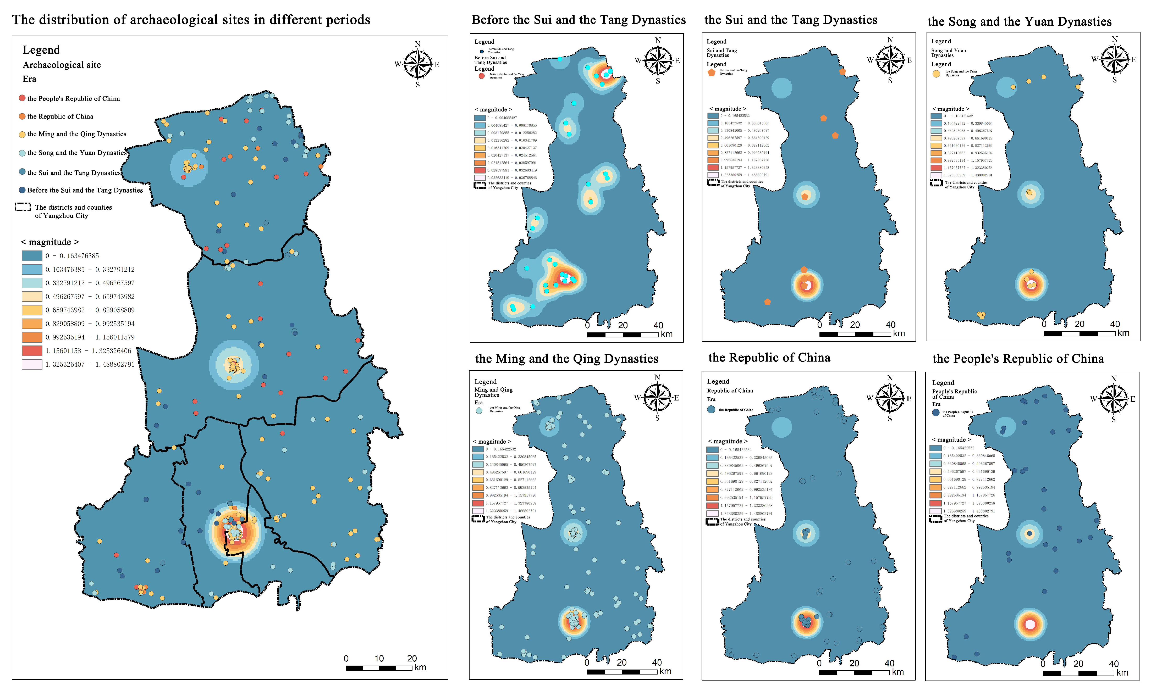
3.2. Spatial Distribution Characteristics

3.2.1. Overall Spatial Distribution (Nearest Neighbor)

The overall spatial distribution of heritage buildings in Yangzhou was quantitatively analyzed using the “Average Nearest Neighbor” tool. The resulting overall nearest neighbor ratio is R = 1.66 > 1, with a mean observation distance of 2936.95 m, an expected mean distance of 1769.92 m, and P = 0 (Table 2). This result indicates that the heritage buildings in Yangzhou are evenly distributed. The geographic distances between the heritage sites are relatively uniform, and the spatial distribution is random. This distribution characteristic may be related to the regional conditions of Yangzhou and the preservation policies for heritage buildings. It reflects a broad and uniform spatial distribution. According to the value analysis result, the overall distribution of heritage buildings in Yangzhou is even; thus, it is recommended to develop spatial preservation and a utilization strategy combining both dispersed and focused approaches.
When analyzing the spatial distribution of different types of heritage buildings in Yangzhou, it becomes apparent that each type exhibits distinct characteristics. For instance, the nearest neighbor ratio for ancient buildings is 1.88, which is much higher than 1, indicating a highly even distribution. This is because ancient buildings were constructed widely throughout historic periods, and their construction was influenced by urban planning and the geographic environment, leading to a more dispersed spatial distribution. Comparatively, the nearest neighbor ratios for ancient sites, stone cave temples and stone carvings, and important modern historical sites and representative buildings are 0.69, 0.63, and 0.65, respectively, all of which are less than 1. This indicates that these types of heritage buildings exhibit a clustered spatial distribution. This is because Yangzhou, located at the intersection of the Yangtze River and the Grand Canal, has historically been a significant transportation hub and commercial center. As a result, ancient sites, stone cave temples and stone carvings, and important modern historical sites and representative buildings are concentrated in Yangzhou, which has been economically prosperous and well-connected due to its strategic location.

3.2.2. Spatial Distribution Characteristics by Type

An analysis of the spatial distribution is presented for the five types of heritage buildings in Yangzhou, including ancient buildings, ancient sites, ancient tombs, important modern historical sites and representative buildings, and stone cave temples and stone carvings (Table 3). The distribution of heritage buildings in Yangzhou shows significant differences across various administrative regions. For ancient sites, Baoying County has 29 sites, accounting for about 58%, while other regions have relatively fewer sites. Regarding ancient tombs, Guangling District has the most with 15 sites, making up 47%. Ancient buildings are the most abundant, totaling 301 sites. Guangling District dominates, with 138 sites, accounting for 46%. Regarding stone cave temple sites and stone carvings, Jiangdu District has eight sites, representing 36%. Regarding important modern historical sites and representative buildings, Guangling District leads with 32 sites, making up 26%. In terms of proportion, ancient buildings dominate the heritage architecture in Yangzhou, accounting for 57.2%. This not only reflects the rich resources used in the preservation of ancient buildings but also demonstrates the emphasis placed on ancient buildings. In contrast, ancient sites and ancient tombs are fewer, accounting for 9.5% and 6.1%, respectively. This suggests that the preservation and discovery of these types of heritage buildings in Yangzhou still require further attention and improvement. In terms of distribution across administrative regions, Guangling District stands out with high numbers across multiple types of heritage buildings, particularly in ancient buildings and important modern historical sites and representative buildings, making it a focal area for the preservation of heritage buildings in Yangzhou. The significant proportion of ancient sites in Baoying County indicates that this region holds unique value in terms of ancient historical relics.

3.2.3. Kernel Density Characteristics of Spatial Distribution

Kernel density analysis is a geostatistical method used to evaluate the clustering trends and distribution patterns of spatial data points. By utilizing the kernel density analysis tool in ArcGIS 10.8, it is possible to conduct a quantitative study of the spatial distribution and evolution characteristics of heritage buildings in Yangzhou (Figure 5). The results of the kernel density analysis reveal that the spatial distribution of heritage buildings in Yangzhou shows significant differences across different historical periods. Before the Sui and Tang Dynasties, the distribution of heritage buildings was relatively dispersed. However, higher concentrations of density were observed in Hanjiang District and Baoying County. This distribution pattern directly reflects the significant historical roles of these regions, which, as political or economic centers, attracted substantial human activity and architectural development. From the Sui and Tang Dynasties to the present, the concentration of heritage buildings in Hanjiang District, Gaoyou District, and Baoying County has become more prominent. This indicates the sustained importance of these regions as transportation hubs, administrative centers, or cultural and religious focal points throughout history. The high concentration of heritage buildings in these regions is direct evidence of their historical development and cultural accumulation. Overall, the spatial distribution of heritage buildings in Yangzhou is uneven. Most of these buildings are concentrated in Hanjiang District, Gaoyou District, and Baoying County. This uneven distribution is closely related to the social structure, level of economic development, and geographic environment of different historical periods. Modern preservation strategies and urban planning have also influenced the current distribution of heritage buildings to some extent.

4. Influencing Factors

4.1. Natural Factors

4.1.1. Water Resources

Water resources are essential for human survival and development, and the origins of many human civilizations are often located along major rivers. The Grand Canal (Opened in 486 BC) is the longest artificial river in the world, stretching from Tongzhou in the north to Hangzhou in the south. It was constructed during the spring and autumn period and completed in the Sui Dynasty; it flourished during the Tang and Song Dynasties, was straightened during the Yuan Dynasty, and was dredged in the Ming and Qing Dynasties. The Grand Canal connects six provinces and five major river systems, with a total length of over 1700 km. The Grand Canal, running from north to south, has been a bridge that connects over two thousand years of Chinese civilization. The Grand Canal segment in Yangzhou was extracted based on the 30 m resolution DEM elevation map of Yangzhou using ArcGIS 10.8 software. Buffer zones were established at 2 km, 4 km, 6 km, 8 km, and 10 km intervals and overlaid with the heritage buildings in Yangzhou. Finally, statistical analysis was performed to determine the locations and proportions of various types of heritage buildings within these buffer zones (Figure 6). As shown in the figure, the majority of heritage buildings are concentrated within 2 km of the water system, while other heritage buildings are primarily distributed within a range of 2–6 km from the water system, and only a small portion of heritage buildings are located beyond 8 km from the water system. From a historical distribution perspective, the number of heritage buildings decreases as the distance from the Grand Canal increases, showing an overall trend of more heritage buildings in the southern area and fewer in the northern area, with more in the western area and fewer in the eastern area. This is due to the low productivity level of early human societies and their strong reliance on the natural environment. Settling close to rivers provided abundant water resources and was highly beneficial for transportation and land utilization.

4.1.2. Terrain

The terrain and landforms of Yangzhou have a significant impact on the spatial and temporal distribution of heritage buildings. On the whole, the terrain of Yangzhou city presents a fan-shaped slope from high to low from west to east, with the western hilly and mountain area being higher and the eastern plains along the river and lake being lower. These terrain differences deeply influence the selection and design of ancient and modern buildings (Figure 7).
In the western hilly mountainous region, the higher terrain provides a natural advantage for defensive structures. The highest peak, Datong Mount, has historically been a site for defensive buildings. Specifically, a core section of the old city wall winds through the foothills of Datong Mount, taking advantage of the undulations to enhance the robustness of the defenses. Ancient city walls, fortresses, and other heritage buildings were often constructed in such areas to take advantage of the natural barriers provided by the high ground, enhancing defense capabilities while offering a wide field of vision. For example, Daming Temple (built in 457), located on top of the middle peak of Shugang, was built in the Southern Dynasty and is a thousand-year-old temple, combining Buddhist temples, cultural relics, and landscapes. This terrain advantage played a role not only in military defense but also influenced the development of urban planning and building forms.
In contrast, the eastern plain areas, being lower in elevation, are more susceptible to natural disasters such as floods. Therefore, flood prevention measures must be carefully considered in the preservation of cultural heritage and the selection of building sites in such areas. In these areas, heritage buildings are often built on relatively higher ground or designed with special flood protection features, such as raised foundations or embankments, to protect cultural heritage from flooding. For example, the Geyuan Garden (built in 1818) in Yangzhou was built on a relatively high mound in the eastern plains, and the elaborate architectural layout and unique garden design of the garden fully demonstrate the charm of the gardens south of the Yangtze River. In addition, the dike system in the eastern plains is an important part of the cultural heritage. These dikes not only serve as flood control but have also become a unique landscape element of Yangzhou.

4.2. Human History

4.2.1. Salt Merchant Culture and Handicraft Culture

In the Western Han Dynasty, Prince Liu Bi of Wu (215–154 BC) initiated the production of salt and coin minting, pioneering the salt industry in Yangzhou. With abundant salt resources in Jiangsu Province, both north and south of the Huaihe River, it became the largest salt production area in China. Yangzhou, benefiting from its geographical position connecting the north and south of the Huaihe River and its canal transportation advantages, served as the administrative center for the salt industry both north and south of the Huaihe River for a long period. Organizations such as the Salt Transport Department, the General Salt Administration of the North and South of the Huaihe River, and the Salt Inspection and Auditing Office were established here, making it a hub for salt merchants. Salt from the north and south of the Huaihe River was primarily supplied to economically developed and densely populated provinces such as Hunan, Hubei, Jiangxi, and Anhui, which demonstrate an enormous market demand and yield significant profits for Yangzhou salt merchants [47].
Yangzhou salt merchants, who frequently traveled across the country, were known for their broad horizons and a tradition of valuing trading and education. They pursued economic success and sought social status, personal fulfillment, family honor, and cultural advancement. This ethos led to their investment in education, the establishment of schools, the collection of calligraphy and paintings, and the construction of lavish residences and gardens that symbolized their wealth and status. Notable structures include the residential buildings of the Lu and Wang salt merchants and meeting venues, such as the Lingnan Guild Hall (built in 1869), the Hubei Guild Hall (built in 1862), and the Sian Guild Hall (built in the Qing Dynasty, exact date unknown), which facilitated business activities among salt merchants [48]. These heritage buildings are primarily concentrated in specific areas associated with salt merchant activities, such as in Nanhexia in Guangling District and in Hanjiang District. This distribution not only reflects the prosperity and lifestyle of the salt merchants but also constitutes an important part of the unique urban landscape and cultural characteristics of Yangzhou.
Additionally, the handicraft industry thrived in Yangzhou, producing high-quality lacquerware, jade ware, copperware, bamboo and wood artifacts, and cosmetics [49]. The warm and humid climate and abundant forest resources, such as lacquer trees and bamboo, provided ample raw materials for the production of crafts such as lacquerware and bamboo artifacts. Convenient transportation also facilitated the acquisition of materials such as jade and copper, fostering craftsmanship to meet the needs of merchants. Shops such as the Xiefuchun Perfume Store, Linze Xinglong Pawnshop, and Mao’s Pawnshop emerged throughout the city, enriching the lives of Yangzhou residents.

4.2.2. Canal Transportation Culture and Hydraulic Engineering Culture

Yangzhou is located to the north of the Yangtze River, south of the Huaihe River, and east of the sea. The inland waterways in this city are crisscrossed within several hundred miles, providing unique advantages for transportation. In the past, Yangzhou became a crucial hub for north–south trade and an important transportation hub, known as a place where goods from all directions gathered. The water transportation history of Yangzhou can be dated back to 486 BC, when King Fuchai of Wu constructed the Han Canal, connecting the Yangtze River and the Huaihe River. After the state of Wu conquered the city of Han, King Fuchai led the construction of Han City and opened the Han Canal, which connected the Yangtze River and the Huaihe River. This project left behind two relic sites of hydraulic engineering: the ancient Han Canal and the old course of the Han Canal. During the Sui Dynasty (581–618), Emperor Yang (569–618) extended the Grand Canal to connect the Yellow River, Huaihe River, and Yangtze River, establishing Yangzhou as a critical node in the water transport network that facilitated economic and cultural exchanges among the three major river basins. This effort laid the foundation for the unprecedented prosperity of Yangzhou during the Tang Dynasty. Emperor Yang of the Sui Dynasty visited Jiangdu three times (Jiangdu: the former name of Yangzhou) and was buried in 618 at Caozhuang, northwest of Yangzhou. His mausoleum remains to this day. In the Song and Yuan Dynasties (960–1368), the canal in Yangzhou was renovated several times, shaping its current route. The resumption of canal transportation following wartime disruptions brought renewed prosperity to Yangzhou. During the Qing Dynasty (1616–1911), frequent visits by Emperor Kangxi (1654–1722) and Emperor Qianlong (1711–1799) to Jiangnan fostered cultural and economic development in Yangzhou. Not only did this bring unprecedented prosperity to Yangzhou, making it one of the eight major cities in China at the time, but it also demonstrated the thriving state of water transportation and hydraulic engineering in this region. From the mid-19th century onward, the silting of the Grand Canal in Shandong Province, along with the shift to maritime and railway transportation, led to a decline in water transportation. Consequently, the construction of heritage buildings associated with water transport ceased.
Alongside the development of canal transportation, various hydraulic facilities also advanced. On the one hand, for flood control purposes, facilities such as the Wanjiatang Dockyard and Shaobo Canal Wharf and gates such as Tieniu Gate, Guoji Gate, and Cheluo Dam were constructed along the canal. These projects contributed to effective canal management, showcasing traditional Chinese water control wisdom [50]. On the other hand, the canal transportation system brought with it diverse goods and people, leading to the emergence of establishments such as the Yucheng Post Station, Royal Dock, and Lvyang Hotel. These venues, serving functions such as goods inspection, transit, accommodation, and dining, were mostly built along the river to facilitate transportation and cargo management, meeting the needs of various groups and contributing to the economic development of Yangzhou from different perspectives.

4.2.3. Literary Culture and Folk Culture

The economic prosperity of Yangzhou during the Han (202–220 BC), Tang (618–907), and Ming and Qing Dynasties (1368–1644) provided the material foundation for the development of culture and art. A stable and thriving environment attracted literati from various regions to gather here and exchange ideas, making Yangzhou one of the cultural and artistic centers of China. Renowned figures such as Wu Daotai, Zhu Ziqing, and the “Eight Eccentrics of Yangzhou” lived in Yangzhou, leaving behind numerous cultural and artistic creations. Many former residences of these notable figures have been preserved to this day [51]. Organizations such as Huachuan Academy, Meihua Academy, and Baoying Academy offered spaces for learning and interaction and fostered the emergence of cultural movements such as the Yangzhou School of Painting and Yangzhou Neo-Confucianism.
Situated in the middle and lower reaches of the Yangtze River Plain, Yangzhou enjoys a humid climate. The abundant living environment and comfortable climate prompted a focus on improving living standards. The literati, merchants, and elite gathered in Yangzhou often pursued novel and high-quality lifestyles, thus setting local trends. Common leisure activities such as bathing and tea drinking not only helped relax the body and mind but also provided excellent opportunities for cultural exchange and social interaction. These activities gradually transitioned from being exclusive to the cultural elite to becoming part of mainstream life. Public cultural venues such as tea houses, bathhouses, and theaters were widely built in Yangzhou, offering spaces for social interaction and relaxation. Traditional establishments such as the Yechun Teahouse and the Yangzhou Bathhouse at No. 23 Suchang Street remain operational to this day.

4.2.4. Religious Culture

The emergence of heritage buildings is closely tied to the local historical and cultural context. Overall, Yangzhou saw the development of numerous religious heritage buildings during the Sui, Tang, and Five Dynasties (907–979). On the one hand, people from various regions gathered in Yangzhou due to its important position as a transportation hub. Consequently, various ideologies, cultures, and religious beliefs also converged here. Taoism first entered Yangzhou during the Han Dynasty, leading to the construction of several renowned Taoist temples, such as the Qionghua Temple and Wudang Palace [52]. In the early Eastern Han Dynasty, Buddhism spread to Yangzhou and flourished most during the Sui, Tang, and Qing Dynasties. At this time, Yangzhou maintained close cultural exchanges with other regions. For example, the Japanese imperial envoys’ visit to Yangzhou during the Tang Dynasty and the journey to Japan by the Buddhist monk Jianzhen (688–763) promoted political, economic, scientific, and cultural exchanges between China and Japan, leaving behind many large Buddhist temples such as Daming Temple, Tianning Temple, and Chongning Temple. Islam arrived in Yangzhou during the early Tang Dynasty [53]. During the Xianchun period in the Southern Song Dynasty (1265–1274), Puhading came to Yangzhou to preach and established Xianhe Mosque, one of the four ancient mosques along the southeastern coast. After he passed away, he was buried on the eastern bank of the ancient Grand Canal, and a memorial garden, Puhading Tomb, was later built in his honor, becoming a symbol of friendly exchanges between Yangzhou and Arab countries. Additionally, during the mid-Yuan Dynasty, Catholicism spread to Yangzhou, and a Gothic-style church was built on the west bank of the ancient Grand Canal during the Qing Dynasty. On the other hand, the attitudes of the ruling classes toward religion also contributed to the formation of religious culture in Yangzhou. For example, during the Southern Dynasty, Emperor Wu of the Liang Dynasty (464–549) made Buddhism the state religion, which contributed to the growth of Buddhism in Yangzhou. The historical economic prosperity in Yangzhou, especially the booming salt industry, brought substantial wealth to this region. The economic prosperity provided the material foundation for the development of religion, with commercial groups such as salt merchants offering economic support for the construction of religious buildings.

4.2.5. Revolutionary Culture

Yangzhou occupies a key strategic position at the crossroads of southern and northern Jiangsu and southern and northern Anhui, making it strategically significant. This geographical location made Yangzhou an important center for material transportation and information dissemination. Since 1925, CPC leaders such as Chen Yi and Su Yu organized and led the people in this region in the New Democratic Revolution. Later, they actively participated in the Anti-Japanese War. For example, the Gaoyou Campaign marked the last liberated city during the Anti-Japanese War, and the Battle of Sanduo River was the largest battle of this campaign, in which the Suzhong Division annihilated Japanese and puppet forces during the war. During the Liberation War, Yangzhou made significant contributions to the success of the Huaihai Campaign and the Crossing of the Yangtze River Campaign, leaving behind a large number of revolutionary heritage buildings. In addition to containing various battlefield sites, Yangzhou became an important center for the exchange of strategic materials and military communications. Locations such as the Suzhong Newspaper Office and the New Fourth Army’s Suzhong Grenade Factory played critical roles in the manufacturing of military equipment, material production, and cultural propaganda, serving as important carriers for the inheritance of revolutionary spirit and the promotion of revolutionary culture. After the founding of the People’s Republic of China, memorials such as the Hekou Liberation War Memorial and the Yangzhou Revolutionary Martyrs Cemetery were built to honor these significant wars and the revolutionary martyrs, inspiring people to remember history and pay tribute to the fallen heroes.

4.2.6. War Destruction

In addition to the positive historical and cultural impacts that promoted the diversified development of heritage buildings in Yangzhou, this city has experienced several wars throughout history, which greatly affected the construction and preservation of heritage buildings in different periods. During the Wei, Jin, and Northern and Southern Dynasties (220–589), widespread chaos in central China and division between the north and south led to frequent warfare in Yangzhou, a key military city in the region of the Yangtze River and the Huaihe River. The city was repeatedly ravaged by invasions by the Wei, internal massacres by the Liu Song Dynasty, and the rebellion of Hou Jing, resulting in the destruction of heritage buildings with none surviving. At that time, the city of Guangling was also referred to as “Wucheng” (meaning “city of desolation”). During the late Tang Dynasty (907–979) and the Five Dynasties, peasant uprisings and warlord conflicts caused severe destruction in Yangzhou, resulting in a relatively small number of preserved heritage buildings from the Sui, Tang, and Five Dynasties. During the Southern Song Dynasty, under the pressure of the Jin Dynasty’s advance, Emperor Gaozong Zhao Gou (1107–1187) moved the capital temporarily to Yangzhou for a year, which contributed to the prosperity of this city. However, in the Southern Song Dynasty, Yangzhou also had long been a battleground for resisting the Jin and Yuan Dynasties. In 1276, Li Tingzhi and Jiang Cai led forces to resist the Yuan army, but when the Yuan army eventually took the city, only a few thousand people remained, and various buildings were significantly damaged. By the time of the Ming Dynasty’s fall, Yangzhou was captured by the Qing army, which carried out a ten-day massacre, resulting in the loss of many heritage buildings from the Ming Dynasty. In the late Qing Dynasty, domestic turmoil and the Taiping Rebellion led to the destruction of many buildings in Yangzhou as the Taiping army entered and exited the city multiple times.

5. Analysis on the Tourism Strategies of Heritage Buildings in Yangzhou

5.1. Regional Integration and Route Planning

The distribution of heritage buildings in Yangzhou is balanced overall, making it suitable for a spatial tourism development strategy combining both dispersed and focused approaches. Following the principle of “regional cooperation, resource integration, complementary advantages, and joint development”, it is important to coordinate the efforts of various district governments, relevant departments, industry associations, and communities. This collaboration should focus on the integration and development of heritage buildings, creating themed routes and cross-district routes.
Based on the distribution characteristics of heritage buildings in different administrative regions of Yangzhou, distinctive tourism routes can be planned. For example, in Guangling District, a route centered on ancient architecture, modern historical sites, and representative buildings could be developed, such as the “Guangling Ancient Charm and Modern Elegance Tour”. This would include salt merchant residences such as the residential buildings of the salt merchant Lu, the Lingnan Guild Hall, the Former Residence of Zhu Ziqing, and old establishments such as the Yangzhou Bathhouse, allowing tourists to experience the prosperity and unique charm of Guangling from ancient times to the present. In Baoying County, a route named “Exploring Baoying’s Ancient Civilization” could be designed, focusing on ancient sites and showcasing their rich historical and cultural significance.
At the same time, given the uneven distribution but regional concentration of heritage buildings, concentrated areas such as Hanjiang District, Gaoyou District, and Baoying County can be integrated to create cross-district tourism routes, such as the “Yangzhou Canal Cultural Heritage Tour”. This route would connect the ancient canal engineering relics in Hanjiang District, the Yucheng Post Station in Gaoyou District, and other canal-related heritage buildings, along with canal scenery to showcase the charm of Yangzhou’s canal transportation and hydraulic engineering culture, allowing tourists to appreciate the cultural characteristics and historical changes in different regions along the canal.

5.2. Sustainable Tourism Development and Preservation

In the process of tourism development, it is necessary to adhere to the principle of prioritizing the preservation of heritage buildings, develop scientific and reasonable preservation plans, and limit tourist flows to avoid overdevelopment that could damage heritage buildings. Regular monitoring and maintenance of ancient buildings and ancient sites are essential to ensure that their historical features and cultural values are passed down.
In addition, the ecological environment should be given priority in tourism development, in line with the natural topography and ecological characteristics of Yangzhou. For tourism routes in the western, hilly mountainous areas, ecological protection awareness should be emphasized to prevent damage to the natural landscape and ecological balance. In the eastern plains, measures to prevent natural disasters such as floods should be strengthened to protect both heritage buildings and tourists. At the same time, tourists should be encouraged to adopt green travel practices, and environmentally friendly tourism methods should be promoted to achieve a harmonious coexistence between tourism and the ecological environment.

5.3. Cultural Integration and Innovative Promotion

In-depth experiential tours based on cultural themes should be developed based on the different types and distribution characteristics of heritage buildings. The rich salt merchant, canal, and literary cultures in Yangzhou should be explored and integrated into the tourism experience. For example, in the salt merchant culture tour, visitors can not only visit salt merchant residences and guild halls but also participate in salt merchant lifestyle activities such as learning traditional salt merchant etiquette and tasting distinctive salt merchant cuisine. In the literary culture tour, cultural lectures and calligraphy or painting experiences can be held at places such as Huachuan Academy and Meihua Academy, allowing tourists to personally experience the charm of the cultural and artistic heritage of Yangzhou. Folk culture resources in Yangzhou, such as traditional leisure activities, including bathing and tea drinking, should also be incorporated into tourism routes. It could be arranged for visitors to enjoy tea at historic teahouses such as Yechun Tea House, experience traditional bathing culture at the Yangzhou Bathhouse, and watch local opera performances such as Yangzhou Pinghua and Yangju, enhancing the fun and cultural richness of the tour and allowing tourists to deeply experience the folk customs of Yangzhou.
To facilitate tourists’ access to and exploration of cultural relics, a smart online tourism platform for heritage buildings in Yangzhou could be developed. This platform would offer services such as online booking, scenic spot navigation, and voice-guided tours, making it easier for tourists to plan their trips. This platform could also recommend nearby heritage buildings and tourist strategies based on search information and browsing histories. Additionally, this platform could publish relevant historical and cultural knowledge, travel guides, and event information about heritage buildings and analyze tourist demand using big data, accurately promoting tourism products and improving service quality and visitor satisfaction.

6. Conclusions and Discussion

ArcGIS 10.8 and mathematical statistics are employed in this study to conduct an in-depth analysis of the temporal and spatial distribution characteristics and influencing factors of 528 heritage buildings in Yangzhou. The findings provide important insights for the preservation and tourism development of heritage buildings in Yangzhou and offer useful references for other regions. The conclusions are as follows:
(1)
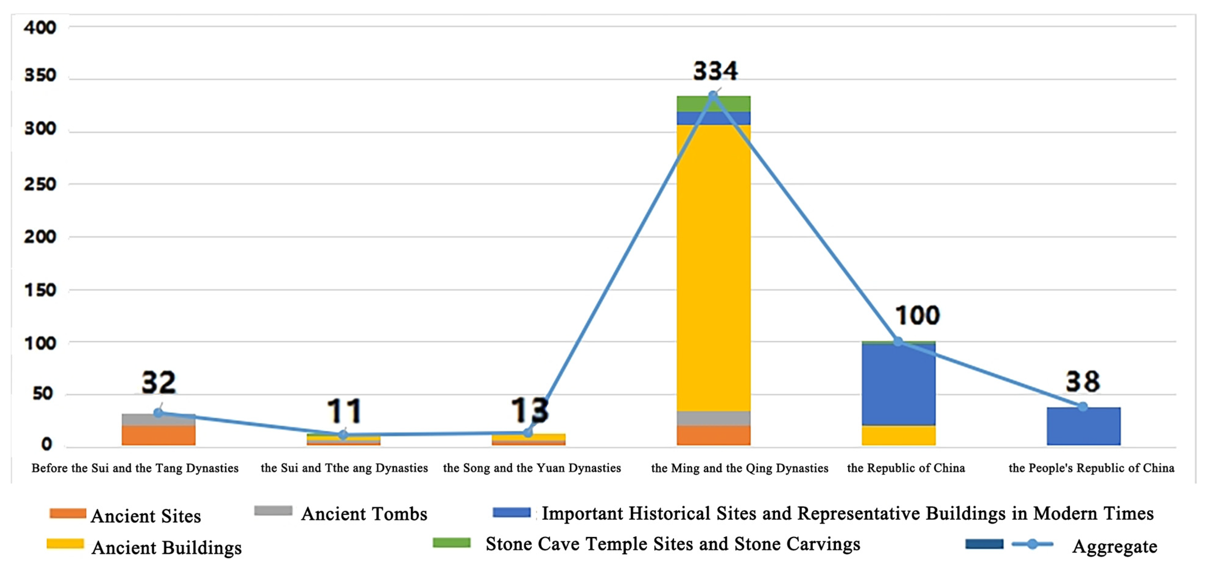
In terms of temporal distribution, the distribution of heritage buildings in Yangzhou follows an “Λ” shape, covering six periods: the period before the Sui and Tang Dynasties, the Sui and Tang Dynasty period, the Song and Yuan Dynasty period, the Ming and Qing Dynasty period, the Republic of China period, and the modern period. The number of heritage buildings varies greatly across different periods and is closely connected to historical development. Few heritage buildings from early periods remain due to natural and human factors. The number of heritage buildings from the Ming and Qing Dynasties and Republic of China periods is huge. The number of heritage buildings in the modern period is limited because of the selection system.
(2)
In terms of spatial and temporal evolution, the centroid of distribution has shifted from southwest to northwest to northeast, showing an overall trend of northeastward movement. The heritage buildings in Yangzhou can be categorized into five types, including ancient sites, ancient tombs, ancient buildings, etc. Ancient sites and tombs are the dominant heritage buildings from the period before the Sui and Tang Dynasties. The types of heritage buildings from the Sui and Tang Dynasties are diversified. The number of ancient buildings from the Ming and Qing Dynasties is huge. Modern historical sites and representative buildings constitute the majority of heritage buildings from the Republic of China period, while modern buildings are the focal type in the modern period.
(3)
In terms of spatial distribution, the heritage buildings in Yangzhou are generally evenly distributed, with a random spatial distribution pattern. Ancient buildings are widely spread out, while ancient sites and tombs are concentrated. Kernel density analysis shows significant aggregation in Hanjiang District, Gaoyou District, and Baoying County, reflecting the historical importance of these areas as transportation hubs, administrative centers, or cultural and religious gathering places.
(4)
In terms of influencing factors, the formation and distribution of heritage buildings in Yangzhou are affected by both natural and human factors, with human factors having a greater overall impact. The primary factors for the construction and development of different types of heritage buildings vary. Similarly, different factors have varying impacts on the formation and development of heritage buildings. Cultural elements, such as the literary culture and salt merchant culture, have played a role in promoting the formation of heritage buildings, while war has had a negative effect on the preservation of heritage buildings. The multidimensional interaction of these factors has a more significant impact on the temporal and spatial distribution characteristics of heritage buildings in Yangzhou.
(5)
Based on the analysis of heritage buildings in Yangzhou, strategies such as regional integration and route planning, prioritizing sustainable tourism development and preservation, and culture fusion and innovative promotion are proposed in this study to promote the all-for-one tourism development and cultural dissemination of Yangzhou.
Overall, research methods such as the average nearest neighbor ratio, kernel density estimation, and the standard deviation ellipse are widely used in rural research and intangible cultural heritage research. Their value as research methods for heritage resources is gradually becoming more apparent. In terms of theoretical contributions, compared to previous studies on heritage buildings, this study redefines heritage analysis through a spatiotemporal lens, challenging static preservation paradigms and providing a reference for understanding the evolution of heritage buildings and their influencing factors from a historical geography perspective. The methods used and the results obtained are significant for enriching the theoretical research on heritage buildings. From a practical perspective, these findings offer valuable insights for the development of all-for-one tourism in Yangzhou and promote the sustainable development of local heritage buildings.
However, there are still some limitations and shortcomings to this study. Although this study gathered data from multiple official sources and referenced the relevant historical literature, some information may still be missing or imprecise. For example, the historical uses of some heritage buildings may have changed over time, but it is difficult to obtain detailed information on the evolution process, which could affect the accuracy of the results. It is advisable to expand data collection channels, strengthen cooperation with local heritage management departments, historical research institutions, and folk cultural organizations, and obtain richer and more accurate information on heritage buildings in future research.
At the same time, modern information technologies, such as big data and the Internet of Things, could be used to establish a more comprehensive database of heritage buildings. In this way, dynamic updating and refined management can be achieved, providing a solid data foundation for further research. When discussing the factors influencing the distribution of heritage buildings in Yangzhou, although aspects such as water transportation resources, natural topography, and human history were considered, there may be other factors that were not sufficiently addressed, such as social class structure and population migration. This makes the research results somewhat limited in explaining the complexity of heritage building distributions. In future research, it is recommended to strengthen the comprehensive analysis of multiple factors affecting the distribution of heritage buildings. Interdisciplinary research methods should be adopted, combining incorporated theories and research methods from sociology, economics, cultural anthropology, and other disciplines to explore the intrinsic relationships and interaction mechanisms between various factors, thereby revealing the deeper causes of the construction and development of heritage buildings.
Additionally, the tourism development of heritage buildings is a long-term task. Further exploration is needed regarding how to effectively preserve heritage buildings during development and how to conduct orderly development under the premise of heritage building preservation.

Author Contributions

Conceptualization, K.W.; methodology, K.W. and X.J.; formal analysis, K.W. and X.J.; investigation, K.W. and X.D.; data curation, X.J.; writing—original draft preparation, K.W.; writing—review and editing, K.W. and X.J.; visualization, X.J., J.Y. and X.D.; supervision, R.Z. All authors have read and agreed to the published version of the manuscript.

Funding

This research was funded by The 2024 National Foreign Experts Programme (H20240686).

Data Availability Statement

Some of the research materials and data used in this paper are available on the internet and through numerous public channels. Additionally, for more detailed information and data, please contact the authors at zhurongseu@foxmail.com.

Acknowledgments

We thank the staff of the Yangzhou Culture and Tourism Department.

Conflicts of Interest

The authors declare no conflicts of interest.

References

  1. Harun, S.N. Heritage building conservation in Malaysia: Experience and challenges. Procedia Eng. 2011, 20, 41–53. [Google Scholar] [CrossRef]
  2. Zhang, Z.; Zou, Y. Research hotspots and trends in heritage building information modeling: A review based on CiteSpace analysis. Humanit. Soc. Sci. Commun. 2022, 9, 394. [Google Scholar] [CrossRef]
  3. Shan, M.; Chen, Y.F.; Zhai, Z.; Du, J. Investigating the critical issues in the conservation of heritage building: The case of China. J. Build. Eng. 2022, 51, 104319. [Google Scholar] [CrossRef]
  4. Xu, Y.; Wang, L. On the ‘Authenticity’ in the Protection of Cultural Heritage Buildings—Reading the Venice Charter, the Nara Document on Authenticity and the Beijing Document. J. Archit. 2011, S1, 85–87. [Google Scholar]
  5. Mısırlısoy, D.; Günçe, K. Adaptive reuse strategies for heritage buildings: A holistic approach. Sustain. Cities Soc. 2016, 26, 91–98. [Google Scholar] [CrossRef]
  6. Osello, A.; Lucibello, G.; Morgagni, F. HBIM and virtual tools: A new chance to preserve architectural heritage. Buildings 2018, 8, 12. [Google Scholar] [CrossRef]
  7. Zhou, Z.; Liu, Z.; Wang, G. Driving Sustainable Cultural Heritage Tourism in China through Heritage Building Information Modeling. Buildings 2024, 14, 3120. [Google Scholar] [CrossRef]
  8. Yu, N.; Degen, W. Influence mechanism and innovation of tourism development pattern of historic streets based on the perspective of tourists: A case of Pingjiang Road of Suzhou. Geogr. Res. 2015, 34, 181–196. [Google Scholar]
  9. Lai, L.W.C.; Davies, S.N.G.; Lorne, F.T. Trialogue on built heritage and sustainable development. Sustainability 2019, 11, 3901. [Google Scholar] [CrossRef]
  10. Milic, R.J.; McPherson, P.; McConchie, G.; Reutlinger, T.; Singh, S. Architectural History and Sustainable Architectural Heritage Education: Digitalisation of Heritage in New Zealand. Sustainability 2022, 14, 16432. [Google Scholar] [CrossRef]
  11. Li, Y.; Zhao, L.; Huang, J.; Law, A. Research frameworks, methodologies, and assessment methods concerning the adaptive reuse of architectural heritage: A review. Built Herit. 2021, 5, 6. [Google Scholar] [CrossRef]
  12. Miran, F.D.; Husein, H.A. Introducing a conceptual model for assessing the present state of preservation in heritage buildings: Utilizing building adaptation as an approach. Buildings 2023, 13, 859. [Google Scholar] [CrossRef]
  13. Vuoto, A.; Funari, M.F.; Lourenço, P.B. Shaping digital twin concept for built cultural heritage conservation: A systematic literature review. Int. J. Archit. Herit. 2023, 18, 1762–1795. [Google Scholar] [CrossRef]
  14. Summerby-Murray, R. Analysing heritage landscapes with historical GIS: Contributions from problem-based inquiry and constructivist pedagogy. J. Geogr. High. Educ. 2001, 25, 37–52. [Google Scholar] [CrossRef]
  15. Munarim, U.; Ghisi, E. Environmental feasibility of heritage buildings rehabilitation. Renew. Sustain. Energy Rev. 2016, 58, 235–249. [Google Scholar]
  16. Bogdan, A.; Chambre, D.; Copolovici, D.M.; Bungau, T.; Bungau, C.C.; Copolovici, L. Heritage Building Preservation in the Process of Sustainable Urban Development: The Case of Brasov Medieval City, Romania. Sustainability 2022, 14, 6959. [Google Scholar] [CrossRef]
  17. Wise, F.; Moncaster, A.; Jones, D. Rethinking retrofit of residential heritage buildings. Build. Cities 2021, 2, 495–517. [Google Scholar] [CrossRef]
  18. Ibrahim, H.S.S.; Khan, A.Z.; Attia, S.; Serag, Y. Classification of heritage residential building stock and defining sustainable retrofitting scenarios in Khedivial Cairo. Sustainability 2021, 13, 880. [Google Scholar] [CrossRef]
  19. Ferrando Ortiz, A.; Viñals Blasco, M.J. Community participation in the restoration of heritage buildings. EGE Rev. Expresión Gráfica Edif. 2023, 18, 80–94. [Google Scholar] [CrossRef]
  20. Currà, E.; D’Amico, A.; Angelosanti, M. HBIM between antiquity and industrial archaeology: Former segrè papermill and sanctuary of hercules in Tivoli. Sustainability 2022, 14, 1329. [Google Scholar] [CrossRef]
  21. Blagojević, M.R.; Tufegdžić, A. The new technology era requirements and sustainable approach to industrial heritage renewal. Energy Build. 2016, 115, 148–153. [Google Scholar] [CrossRef]
  22. Li, Y. Current problems and countermeasures for the protection of cultural relics and buildings. People’s Forum 2024, 18, 96–100. [Google Scholar]
  23. Lin, J.; Zhang, F. The precursor of the national architectural heritage protection system—The influence of the concept and practice of conservation of heritage buildings by the China Construction Society. J. Archit. 2012, S1, 92–95. [Google Scholar]
  24. Mollo, L.; Agliata, R.; Palmero Iglesias, L.M.; Vigliotti, M. Typological GIS for knowledge and conservation of built heritage: A case of study in Southern Italy. Inf. Constr. 2020, 72, 357. [Google Scholar]
  25. Yang, X.; Grussenmeyer, P.; Koehl, M.; Macher, H.; Murtiyoso, A.; Landes, T. Review of built heritage modelling: Integration of HBIM and other information techniques. J. Cult. Herit. 2020, 46, 350–360. [Google Scholar]
  26. Seo, H. R–C–C fusion classifier for automatic damage detection of heritage building using 3D laser scanning. J. Civ. Struct. Health Monit. 2024, 15, 927–941. [Google Scholar]
  27. Croce, V.; Caroti, G.; De Luca, L.; Jacquot, K.; Piemonte, A.; Véron, P. From the semantic point cloud to heritage-building information modeling: A semiautomatic approach exploiting machine learning. Remote Sens. 2021, 13, 461. [Google Scholar] [CrossRef]
  28. Yang, X.; Qiu, B.; Tian, Z. Research on the application method of historical building protection under the integration of multiple technologies. Int. Arch. Photogramm. Remote Sens. Spat. Inf. Sci. 2022, 43, 923–928. [Google Scholar]
  29. Roslan, R.; Said, S.Y. Elements in Assessing the Architectural Characteristics of Heritage Buildings. Environ.-Behav. Proc. J. 2020, 5, 313–318. [Google Scholar]
  30. Ornelas, C.; Sousa, F.; Guedes, J.M.; Breda-Vázquez, I. Monitoring and Assessment Heritage Tool: Quantify and classify urban heritage buildings. Cities 2023, 137, 104274. [Google Scholar]
  31. Ye, P.; Kweon, J.; He, J. Big data analysis and evaluation for vitality factors of public space of regenerated industrial heritage in Luoyang. Int. J. Low-Carbon Technol. 2024, 19, 79–89. [Google Scholar] [CrossRef]
  32. Zhang, Y.; Zhang, Q. A model approach for post evaluation of adaptive reuse of architectural heritage: A case study of Beijing central axis historical buildings. Herit. Sci. 2023, 11, 57. [Google Scholar] [CrossRef]
  33. Wong, P.F. A framework of sustainability refurbishment assessment for heritage buildings in Malaysia. IOP Conf. Ser. Earth Environ. Sci. IOP Publ. 2019, 268, 012011. [Google Scholar] [CrossRef]
  34. Donghui, C.; Guanfa, L.; Wensheng, Z.; Qiyuan, L.; Shuping, B.; Xiaokang, L. Virtual reality technology applied in digitalization of cultural heritage. Clust. Comput. 2019, 22, 10063–10074. [Google Scholar] [CrossRef]
  35. Noor, S.; Shah, L.; Adil, M.; Gohar, N.; Saman, G.E.; Jamil, S.; Qayum, F. Modeling and representation of built cultural heritage data using semantic web technologies and building information model. Comput. Math. Organ. Theory 2019, 25, 247–270. [Google Scholar] [CrossRef]
  36. Cheng, J.C.P.; Zhang, J.; Kwok, H.H.L.; Tong, J.C. Thermal performance improvement for residential heritage building preservation based on digital twins. J. Build. Eng. 2024, 82, 108283. [Google Scholar] [CrossRef]
  37. Li, Y.; Zhao, L.; Chen, Y.; Zhang, N.; Fan, H.; Zhang, Z. 3D LiDAR and multi-technology collaboration for preservation of built heritage in China: A review. Int. J. Appl. Earth Obs. Geoinf. 2023, 116, 103156. [Google Scholar] [CrossRef]
  38. Huang, X.; van Weesep, J. Cultural values and urban planning in china: Evidence of constraints and agency in the development of the historic city of Yangzhou. J. Urban Hist. 2021, 47, 157–178. [Google Scholar] [CrossRef]
  39. Deng, S.; Chen, T.; Yang, N.; Qu, L.; Li, M.; Chen, D. Spatial and temporal distribution of rainfall and drought characteristics across the Pearl River basin. Sci. Total Environ. 2018, 619, 28–41. [Google Scholar] [CrossRef]
  40. Yongqi, L.; Ruixia, Y.; Pu, W.; Anlin, Y.; Guolong, C. A quantitative description of the spatial–temporal distribution and evolution pattern of world cultural heritage. Herit. Sci. 2021, 9, 80. [Google Scholar] [CrossRef]
  41. Zhang, J.; Sun, H.; Xu, S.; Aoki, N. Analysis of the spatial and temporal distribution and reuse of urban industrial heritage: The case of Tianjin, China. Land 2022, 11, 2273. [Google Scholar] [CrossRef]
  42. Ding, B. Analysis of Yangzhou’s urban spatial evolution and development based on historical perspective. Chin. Foreign Archit. 2018, 5, 78–80. [Google Scholar]
  43. Pan, M. On the Sustainable Protection and Utilisation of Traditional Residences in Historic Cities—Analyzing the Integral Protection of Yangzhou’s Old Town. China Famous City 2014, 9, 9–16. [Google Scholar]
  44. Pan, B. A Brief Discussion on the Historical View of Feng Shui in Yangzhou. J. Yangzhou Vocat. Univ. 2014, 18, 11–16+31. [Google Scholar]
  45. Zhou, K.; Wu, W.; Li, T.; Dai, X. Exploring visitors’ visual perception along the spatial sequence in temple heritage spaces by quantitative GIS methods: A case study of the Daming Temple, Yangzhou City, China. Built Herit. 2023, 7, 24. [Google Scholar]
  46. Tao, W.U.; Yuanhua, S. Research on the Public Perception of Yangzhou Historical and Cultural Districts Based on Network Review Text Analysis. J. Landsc. Res. 2023, 15, 36. [Google Scholar]
  47. Li, P. The dream of Yangzhou in the Ming and Qing dynasties: An immigrant city built on the salt trade. China Salt Ind. 2022, 17, 57–59. [Google Scholar]
  48. Ren, S. Impact of the Grand Canal on the Development of Yangzhou Industry and Commerce in the Ming and Qing Dynasties. J. Anqing Norm. Univ. Soc. Sci. Ed. 2023, 42, 92–97. [Google Scholar]
  49. Luo, J. Protection and Development of Dongguan Historical and Cultural Block in Yangzhou. J. Landsc. Res. 2020, 12, 95–97. [Google Scholar]
  50. Nishioka, H.; Lv, J. Urban water conservancy in Yangzhou during the Song Dynasty. Urban Dev. Res. 1996, 1, 48–50. [Google Scholar]
  51. Sun, L.; Kang, K. Canals, Salt Merchants, Literati, Calligraphers and Painters and Yangzhou New Year Paintings—On the Elite Cultural Factors in Yangzhou New Year Paintings of the Qing Dynasty. Art Daguan 2020, 7, 114–119. [Google Scholar]
  52. He, J. The new tendency of the compilation of local history documents and the study of Chinese religious history. J. Renmin Univ. China 2014, 28, 140–146. [Google Scholar]
  53. Jiang, S. Introduction to the Religious Cultural Remains of the Grand Canal. Chin. Relig. 2024, 4, 22–27. [Google Scholar]
Figure 1. The study area.
Buildings 15 01081 g001
Figure 2. Temporal pattern of heritage buildings in Yangzhou by historical period.
Buildings 15 01081 g002
Figure 3. Number and types of heritage buildings in Yangzhou across different historical periods.
Buildings 15 01081 g003
Figure 4. Distribution direction and centroid of heritage buildings in Yangzhou.
Buildings 15 01081 g004
Figure 5. Kernel density map of spatial distribution across administrative regions.
Buildings 15 01081 g005
Figure 6. Buffer zones of the lake and river systems in Yangzhou.
Buildings 15 01081 g006
Figure 7. Digital elevation of Yangzhou and distribution of heritage buildings.
Buildings 15 01081 g007
Table 1. Basic information on the distribution of heritage buildings in Yangzhou across different historical periods.
PhaseAncient SitesAncient TombsAncient BuildingsStone Cave Temple Sites and Stone CarvingsImportant Modern Historical Sites and Representative BuildingsTotal
(Percentage)
The Sui and Tang dynasties201200032
(0.61)
The Sui and Tang dynasties4241011
(2.08)
The Song and Yuan dynasties5260013
(2.46)
The Ming and Qing dynasties21132731512334
(63.26)
Republican period 0219178100
(18.94)
Since modern times00003838
(7.20)
Total
(Percentage)
50
(9.47)
31
(5.87)
302
(57.20)
17
(3.22)
128
(24.24)
528
(100.00)
Table 2. Nearest neighbor ratio of heritage buildings in Yangzhou.
FormExpected Average Distance/mAverage Observation Distance/mNearest Neighbour Ratiop-ValueZ-ScoreSpatial Distribution Categories
Ancient sites5798.934007.310.690.00−4.14agglomerative
Ancient tombs7175.816575.350.920.37−0.91agglomerative
Ancient buildings2339.714390.481.880.0029.09stochastic
Stone Cave Temple Sites and Stone Carvings8654.355421.330.630.00−3.35agglomerative
Important Modern Historical Sites and Representative Buildings3675.072370.710.650.00−7.50agglomerative
Synthesis1769.922936.951.660.0028.93stochastic
Table 3. Spatial distribution by type across administrative regions.
FormAdministrative AreaTotal
(Including Percentage)
Baoying CountyGaoyou CityGuangling DistrictHanjiang DistrictJiangdu DistrictYizheng City
Ancient sites298040950
(9.47%)
Ancient tombs1111151332
(6.06%)
Ancient buildings2687138152411301
(57.10%)
Stone Cave Temple Sites and Stone Carvings7313822
(4.10%)
Important Modern Historical Sites and Representative Buildings4023327138123
(23.30%)
Total113122172444631528
(100%)
Disclaimer/Publisher’s Note: The statements, opinions and data contained in all publications are solely those of the individual author(s) and contributor(s) and not of MDPI and/or the editor(s). MDPI and/or the editor(s) disclaim responsibility for any injury to people or property resulting from any ideas, methods, instructions or products referred to in the content.

