


Research on the Dynamic Defensive Efficiency of Traditional Military Settlements in the Ming Dynasty: A Case Study of Ningbo Coastal Defense, China

Abstract
1. Introduction
2. Study Area
- (1)
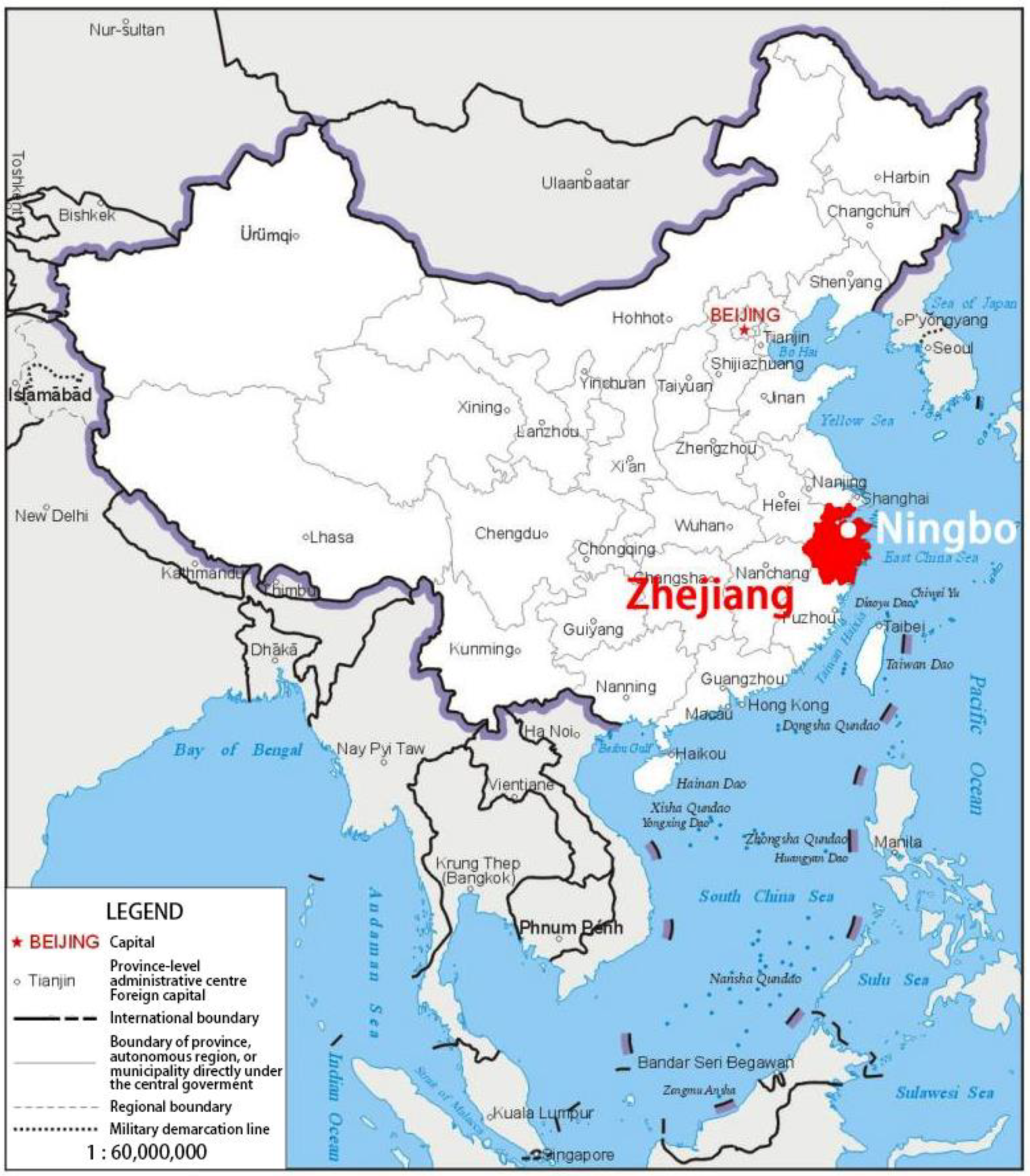
- Zhejiang defense area has always been the focus of the Ming government coastal defense construction, and Ningbo with the geographical characteristics of the Zhejiang coastal defense gateway (Figure 1) also naturally became the top priority of the Ming and Qing dynasty coastal defense deployment; the construction of coastal defense military colony has a high quantity and quality. Therefore, the coastal defense military colony system in Ningbo during the Ming Dynasty is very representative, and the quantitative analysis of the defensive efficiency of the Ningbo can reflect the construction law of the national coastal defense military colony system.
- (2)
- The comprehensive deployment and construction of coastal defense in Ningbo began during the Hongwu period of the Ming Dynasty. According to local historical records, the Ningbo area experienced 53 years of large-scale invasion during the Ming Dynasty. Therefore, the coastal defense of Ningbo has been in the process of dynamic improvement, with obvious dynamic and sustainable characteristics, which can reflect the ideas and strategies of resisting Wokou in different periods of the Ming Dynasty and can provide references for the study of other military settlements.
- (3)
- Due to Ningbo’s special position in China’s Ming Dynasty coastal defense system, a wealth of information has been left behind, laying the foundation for the defensive efficiency study.
2.1. Three Major Defense Areas of Ningbo Traditional Military Settlements
2.2. Ming Dynasty Ningbo Coastal Defense Battle Overview for Four Periods
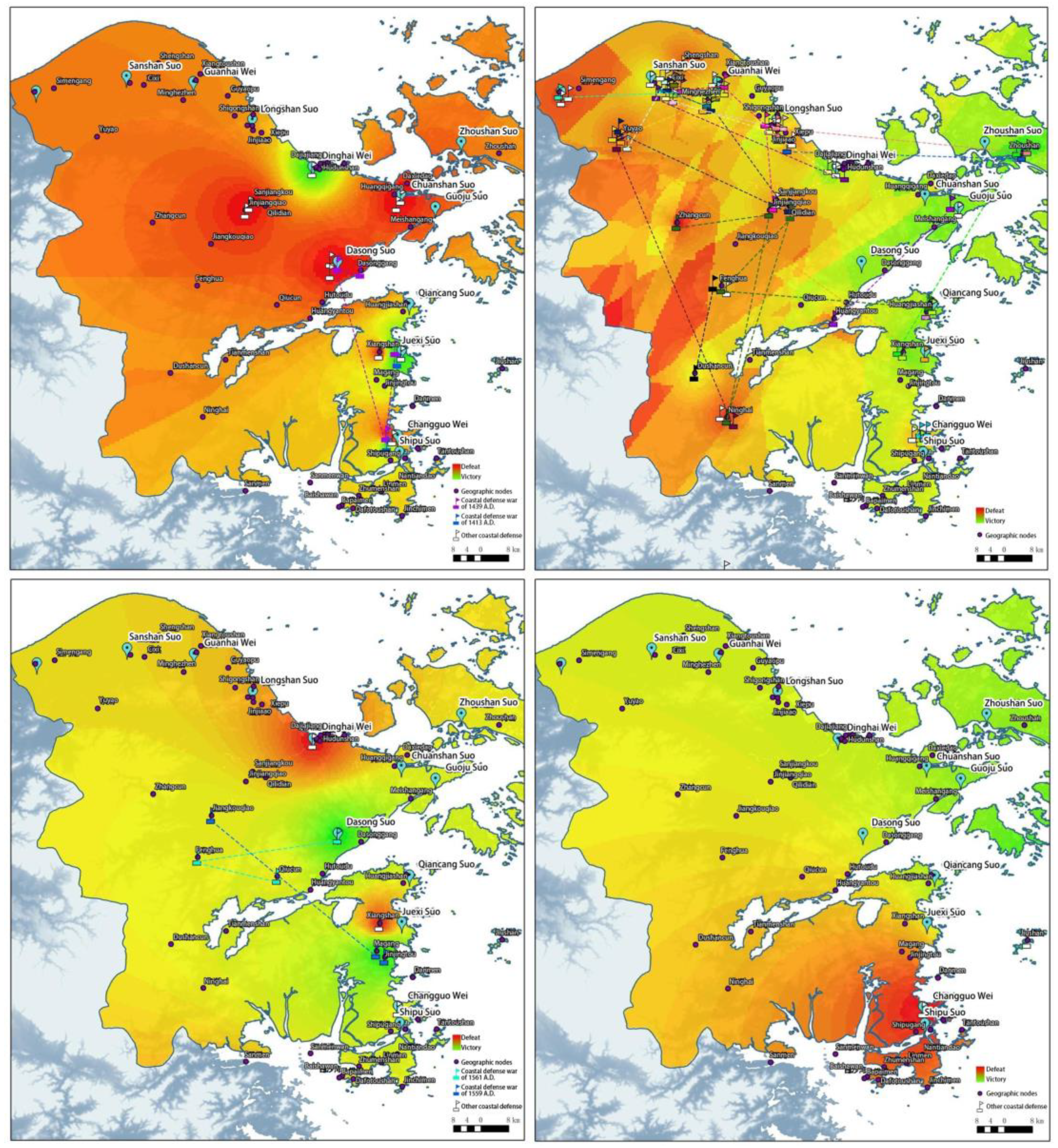
- The first period (1368–1521) is the period from Hongwu to Zhengde. As the Ming regime had not yet stabilised, Wokou invaded the southeast coast. Ming Taizu thus strengthened the maritime and land forces and established a solid coastal defense system. The coastal defense settlements—Weisuo forts in Ningbo—were established during this time. Marking the routes of the Wokou invasions, it can be seen that the two Wokou invasion raids in 1413 and 1439 had a large area of influence, even across war areas. It can be seen that the construction of the coastal defense system as a countermeasure must have a holistic mindset to achieve victory through the concerted defense between the war areas.
- The second period (1522–1557) is the middle and early period of Jiajing and the period of most concentrated Wokou aggression throughout the Ming dynasty. Compared with the early Ming period, the Jiajing period saw complex and significant changes in defense strategies. Therefore, the Jiajing Period is divided into two sections for comparative analysis. After the Hongwu Period, the peaceful marine environment led to a series of declining coastal defense constructions. In the early Jiajing Period, the coastal defense of Zhejiang and Fujian had been abandoned for a long time. The two coastal invasions in 1522 and 1523 forced the government to tighten the sea ban policy, but contrary to expectations, this triggered large-scale invasions in Wokou in the middle of the Jiajing period, characterised by a large number of times, long time, large scale, wide area, and repeated and winding routes. The defeat rate of the Lin Guan war area is significantly higher than the other two war areas; the scope of Wokou’s invasion even expanded into the interior, and the coastal defense system was significantly damaged. It can be seen that at this period, the expansion of Wokou’s power often made it impossible for a single coastal defensive Wei Suo fort to intercept and destroy them in time, and it was necessary for multiple coastal defense forts to work together.
- The third period (1558–1566) is the late Jiajing Period. In response to the Wokou Invasion, the Ming Dynasty began to take measures to strengthen the coastal defense forces. In particular, the defense systems of Zhejiang and Nanzhili were more complete. Both naval and land forces were stronger than before, and military settlements were repaired. Wokou’s power was also weakened. Coastal defense battles in Ningbo and the whole Zhejiang Province were significantly reduced.
- The fourth period (1567–1644) is the period from Longqing to Chongzhen. The force that remained in Wokou was no longer large, and the damage was relatively light. There were several attacks on the southern coast of Ningbo, which no longer poses a threat. By the end of the Ming Dynasty, Wokou was basically nonexistent near China’s coastal areas.
3. Methodology
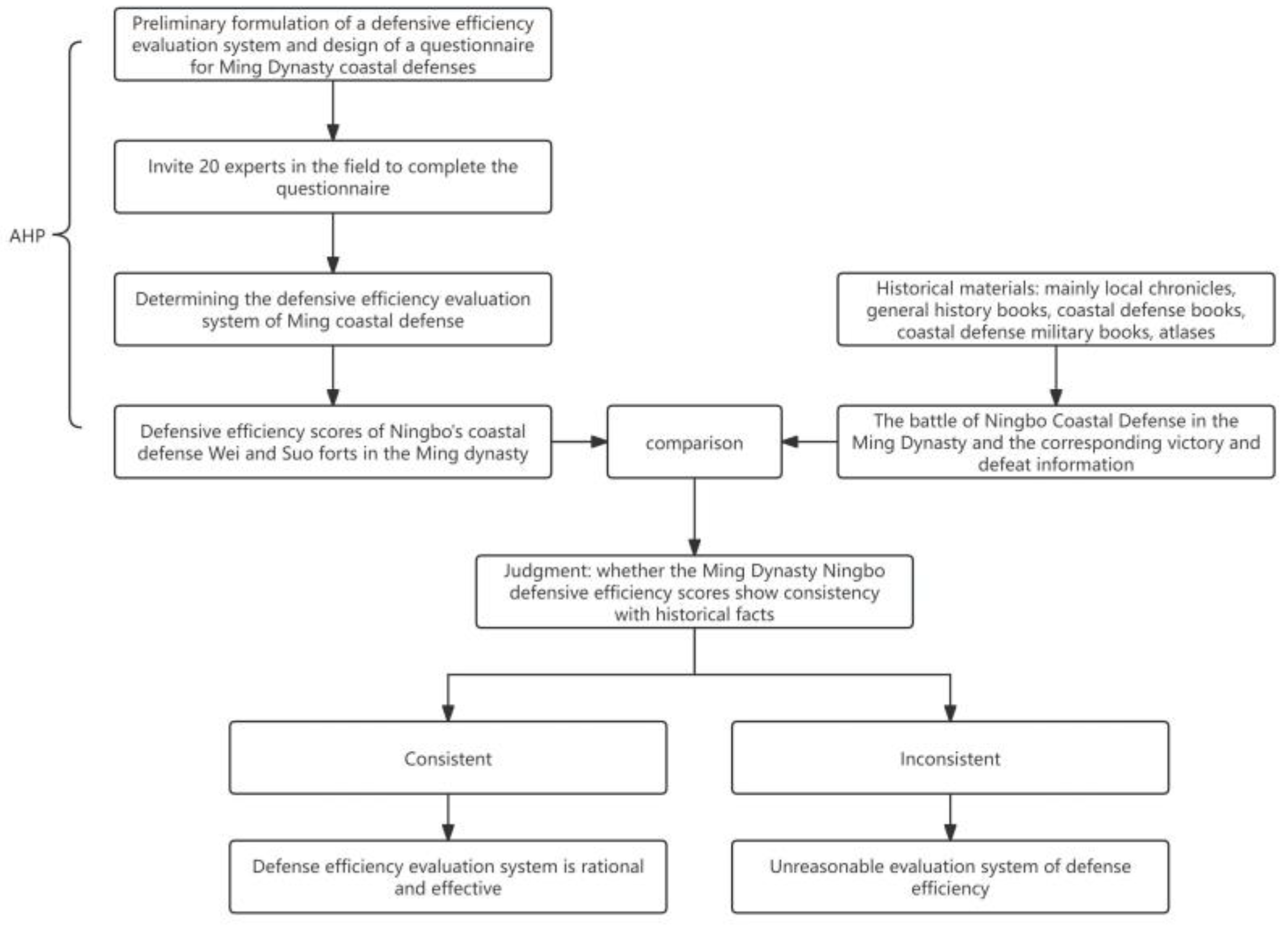
3.1. Materials
3.2. GIS Analysis
3.3. Analytic Hierarchy Process (AHP)
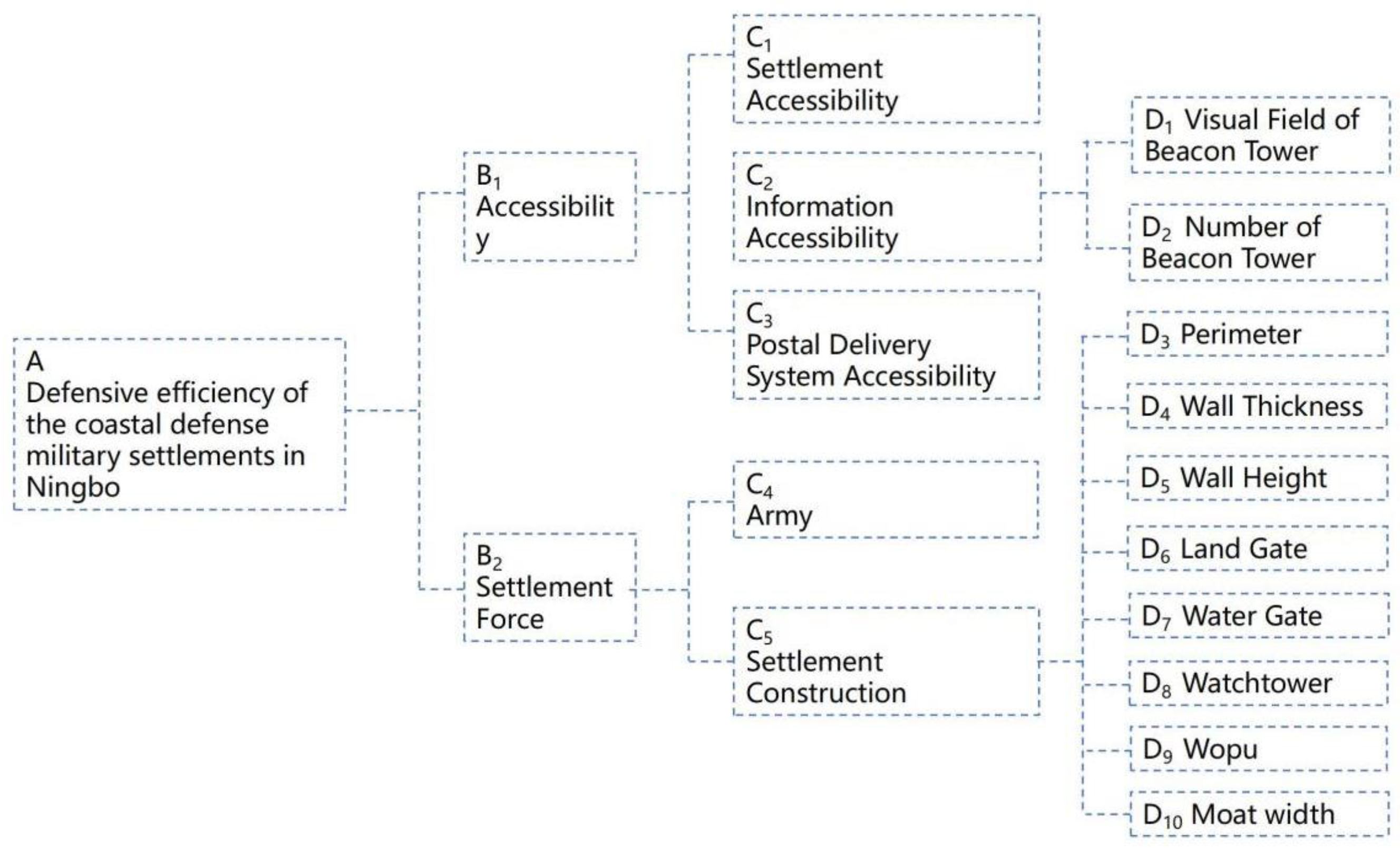
- ①
- An: The overall objective of this study—the defensive efficiency of the coastal defense military settlements in Ningbo (A).
- ②
- Bn: The overall objective is further divided into two intermediate indicators: the ability for mutual support among settlements (accessibility, B1) and the military strength of each individual settlement (settlement forces, B2).
- ③
- Cn: This level further breaks down the intermediate indicators.
- ④
- Dn: At the Cn level, some factors can be directly quantified, while others need further breakdown. Information accessibility (C2) includes the number of beacon towers (D1) and the visual field of beacon towers (D2). Settlement forces (C5) include perimeter (D3), wall thickness (D4), wall height (D5), land gates (D6), water gates (D7), watchtowers (D8), Wopu (D9, small huts built on top of the wall’s horse face for soldiers to shelter from the weather and store weapons), and moats (D10).
3.3.1. Weight Calculate
3.3.2. Consistency Test
3.3.3. Normalization
4. Results
4.1. Accessibility (B1)
4.1.1. Settlement Accessibility (C1)
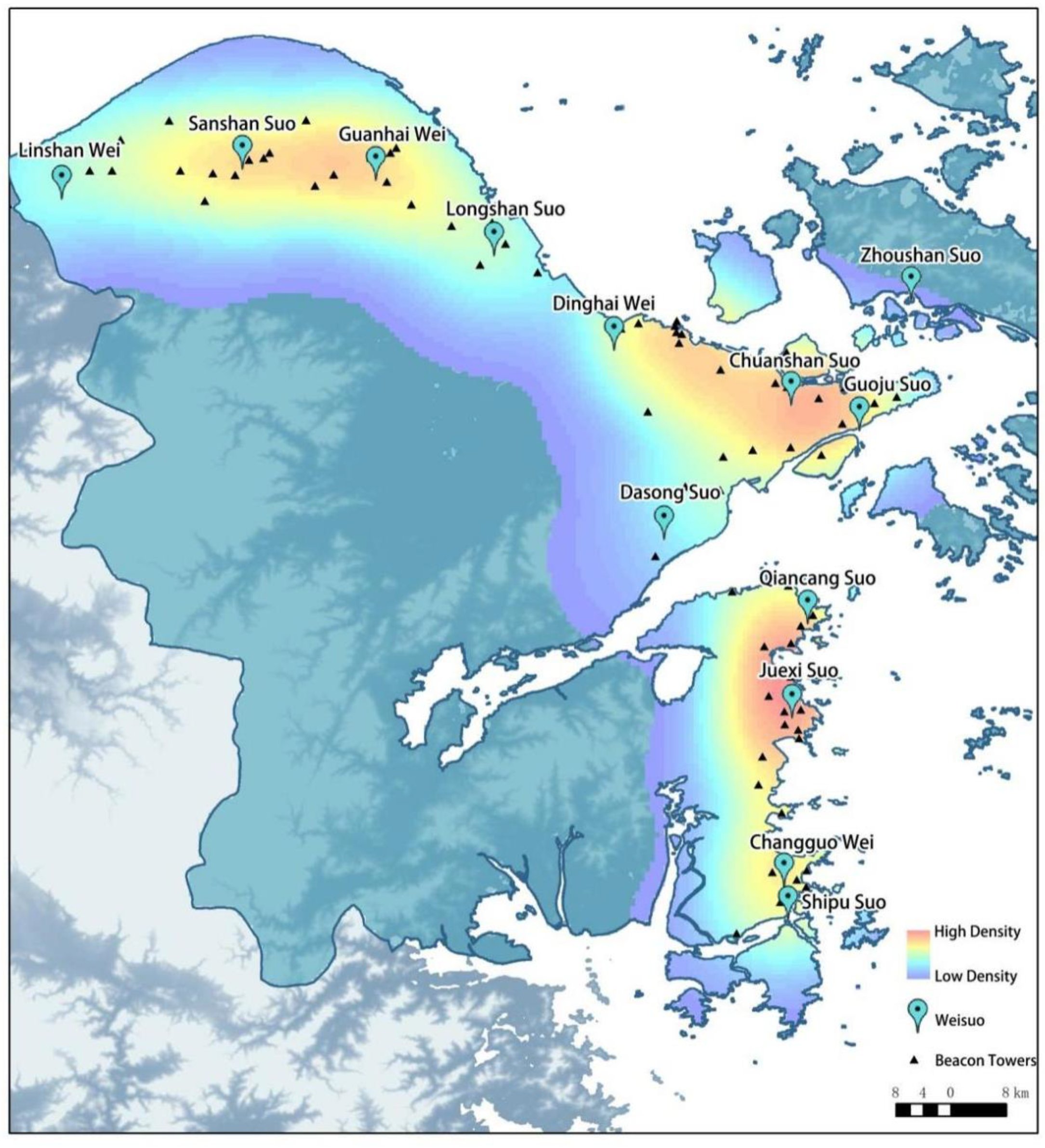
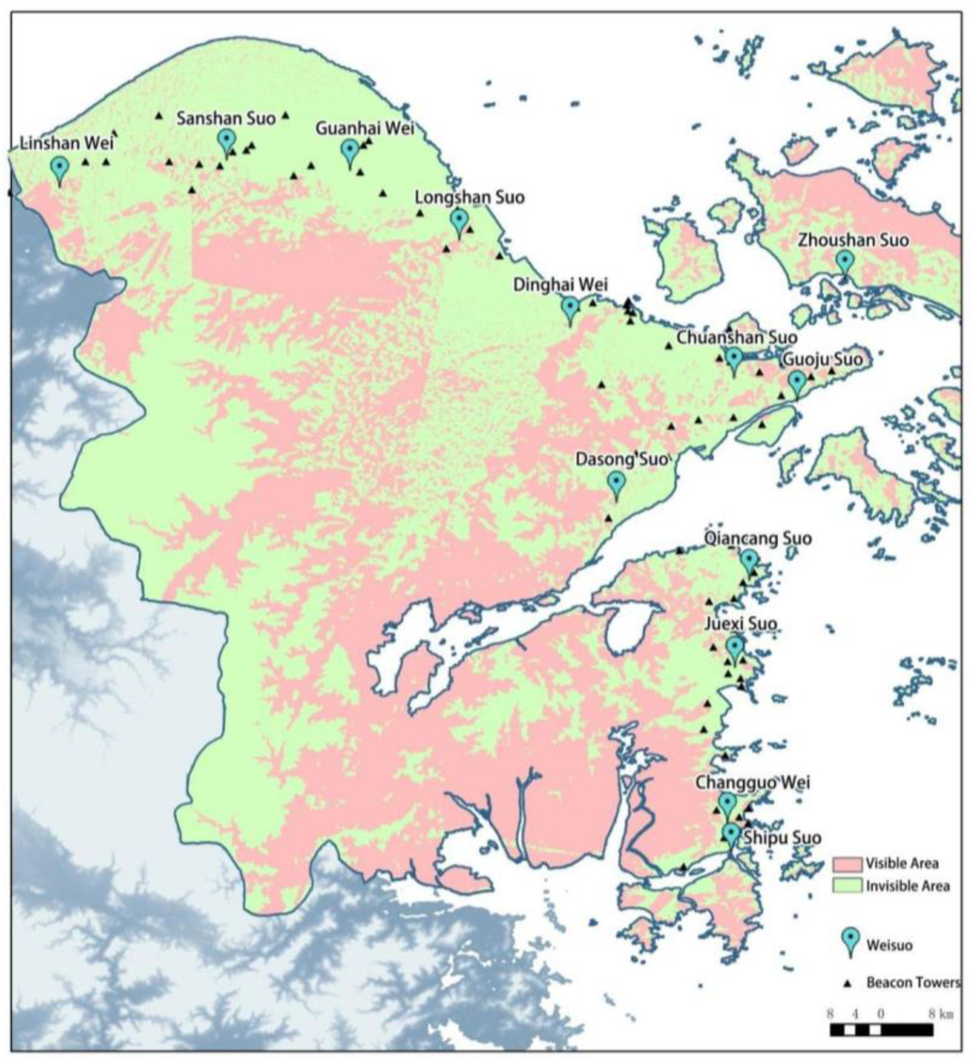
4.1.2. Information Accessibility (C2)
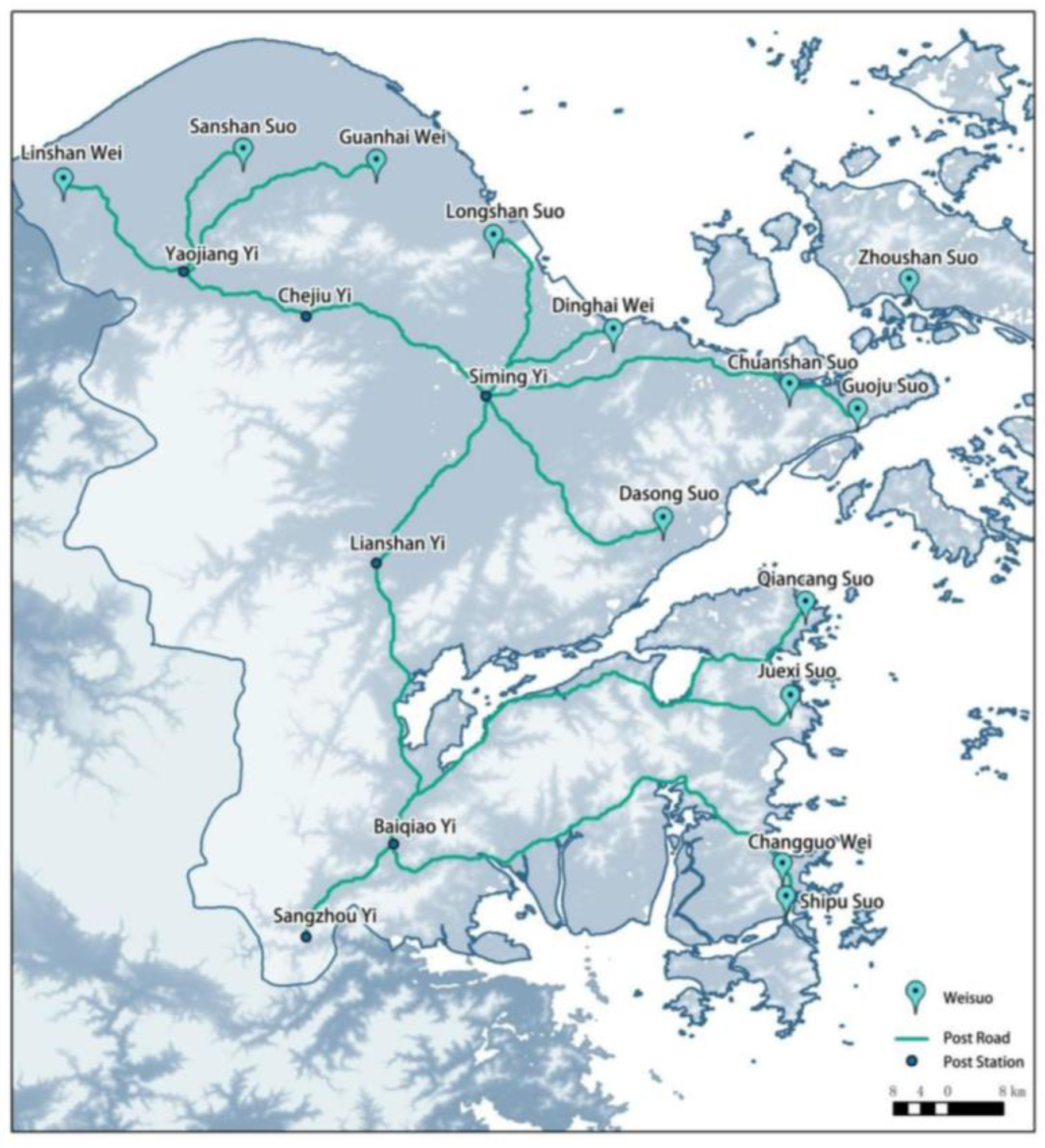
4.1.3. Postal Delivery System Accessibility (C3)
4.2. Settlement Forces (B2)
4.2.1. Army Power (C4)
4.2.2. Settlement Construction (C5)
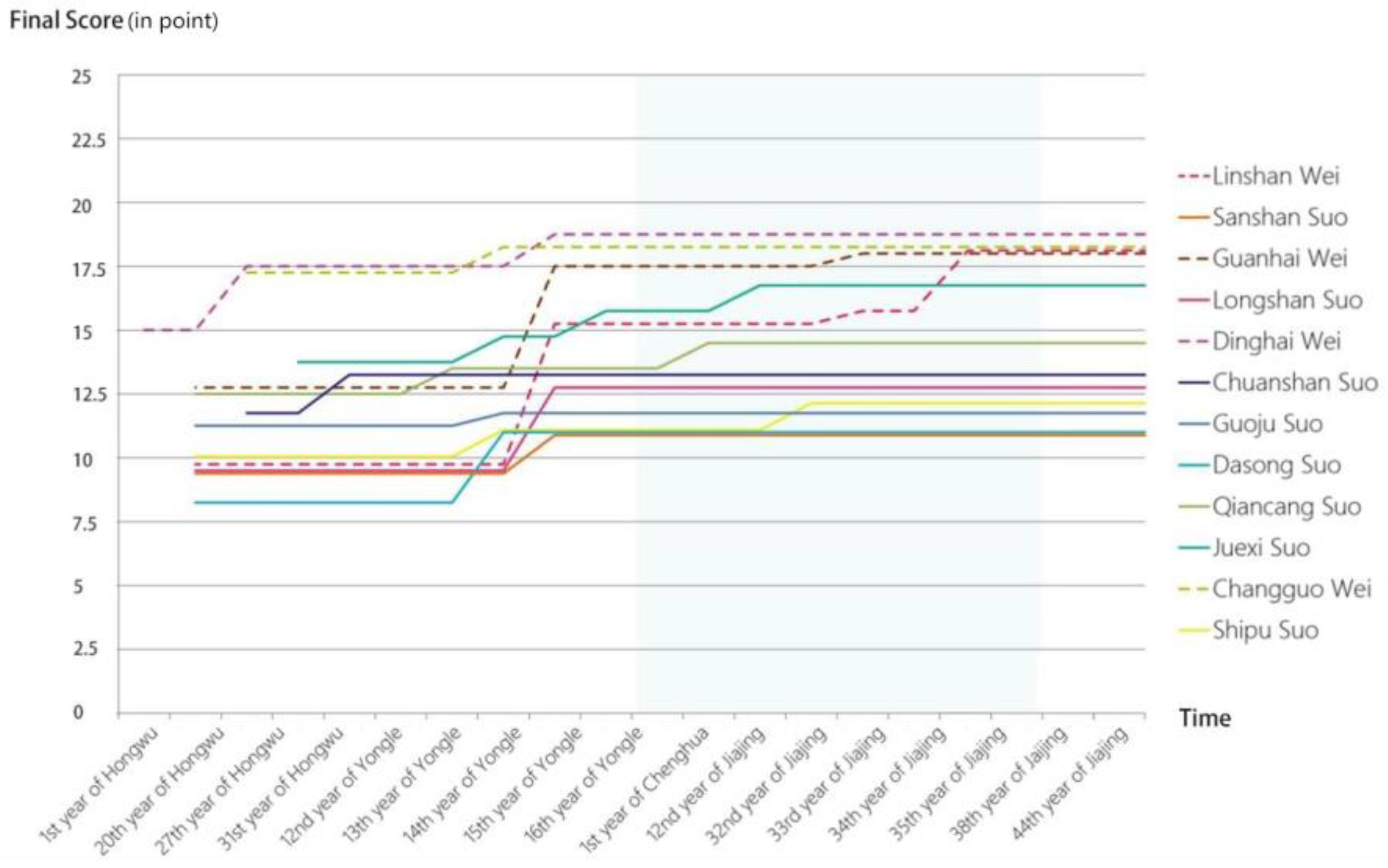
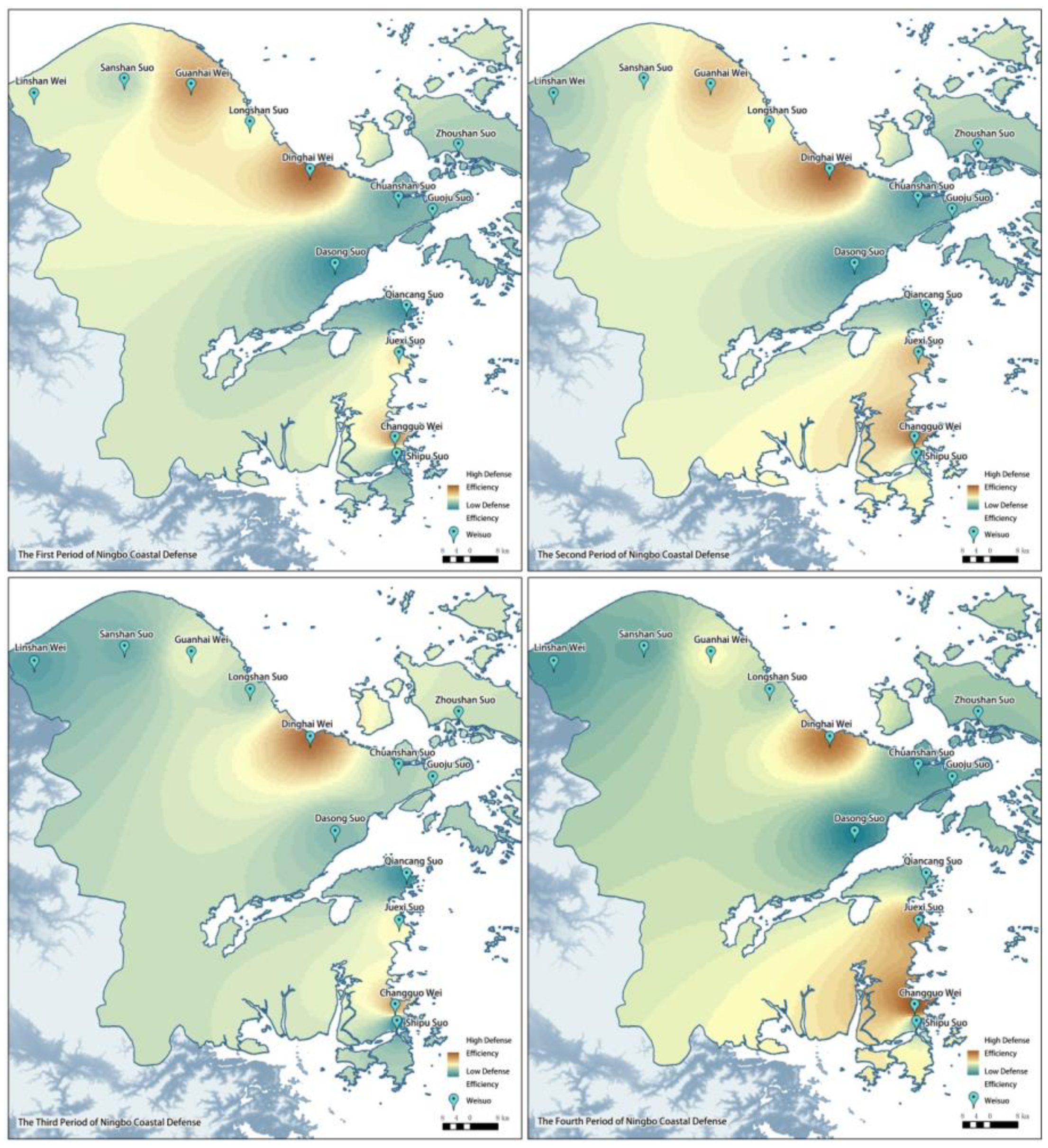
4.3. Final Score
5. Conclusions
- (1)
- For AHP: Under the AHP system, the two factors, accessibility (B1) and settlement force (B2), are equally important in the defense efficiency according to the opinions of the interviewed experts. The more obvious difference in weight is the eight factors included in Settlement Construction (C5), of which the highest weighted factors are Perimeter (D3) and Wall Height (D5), and the lowest weighted are Watchtower (D8) and Wopu (D9).
- (2)
- For the efficiency of China’s Ming Dynasty coastal defense: the changes in defensive efficiency in four periods reflect the four phases of the construction of China’s Ningbo coastal defense in the Ming Dynasty, the period of preliminary construction, the period of full-scale construction after repeated Wokou invasions, the period of basic completion, and the period in which Wokou invasions were reduced in large quantities and the point of attack was relocated to the south. Therefore, it can also be seen that, on the one hand, the construction of coastal defense in Ningbo, China during the Ming Dynasty was closely associated with Wokou invasions, and the spatial distribution of battles drove the continuous construction and improvement of coastal defense settlements, and that the Ming Dynasty was an important construction period for coastal defense in ancient China; on the other hand, the improvement of the coastal defense system had an obvious effect on the defense against Wokou invasions.
- (3)
- For the proposed methodology: the validity of the evaluation system is verified through the comparison between the AHP scoring results and the real battle victory and defeat situations in history, forming a reproducible set of quantitative methodology for the defensive efficiency of the Ming Dynasty coastal defense in China.
6. Discussion
Author Contributions
Funding
Data Availability Statement
Conflicts of Interest
Appendix A

| Category | Specific Materials |
|---|---|
| Local Chronicles | Song Dynasty: Luo Jun, Baoqing Siming Zhi (Annals of Siming in the Baoqing Era), 2nd year of Baoqing (1226); Mei Yingfa and Liu Xi, Kaiqing Siming Xu Zhi (Continuation of Siming Annals in the Kaiqing Era), 1st year of Kaiqing (1259) |
| Ming Dynasty: Hu Zongxian (compiler), Xue Yingqi (editor), Jiajing Zhejiang Tong Zhi (General Gazetteer of Zhejiang in the Jiajing Era), 40th year of Jiajing (1561); Yang Shi (compiler), Ningbo Jun Zhi (Gazetteer of Ningbo Prefecture), 4th year of Chenghua (1468); Zhou Xizhe and Guan Jian (compilers), Zhang Shiche (editor), Ningbo Fu Zhi (Gazetteer of Ningbo Prefecture), 39th year of Jiajing (1560); Huang Runyu, Ningbo Fu Jianyao Zhi (Concise Gazetteer of Ningbo Prefecture), Chenghua period (1465–1487); Geng Zongdao et al., Linshan Wei Zhi (Gazetteer of Linshan Garrison), Jiajing period (1522–1566); Zhou Li (compiler), Guanhai Wei Zhi (Gazetteer of Guanhai Garrison), 41st year of Jiajing (1562); Zhang Shiche et al., Dinghai Xian Zhi (Gazetteer of Dinghai County), 42nd year of Jiajing (1563); Yao Zongwen (compiler), Cixi Xian Zhi (Gazetteer of Cixi County), 4th year of Tianqi (1624); Mao Dejing and Wang Xiangtong (compilers), Yang Minyi and Zhou Maobo (editors), Xiangshan Xian Zhi (Gazetteer of Xiangshan County), 35th year of Jiajing (1556) | |
| Qing Dynasty: Yu Wanchuan (compiler), Yu Yue (editor), Zhenhai Xian Zhi (Gazetteer of Zhenhai County), 5th year of Guangxu (1879); Hushan Zhi (Gazetteer of Hushan), 11th year of Daoguang (1831); Wen Xingdao (chief editor), Kangxi Yin Xian Zhi (Gazetteer of Yin County in the Kangxi Era), 24th year of Kangxi (1685); Zhang Xian (compiler), Zhou Daozun et al. (editors), Xianfeng Yin Xian Zhi (Gazetteer of Yin County in the Xianfeng Era), 6th year of Xianfeng (1856) | |
| Modern Period: Yang Jifang (chief editor), Yuyao Liu Cang Zhi (Gazetteer of Six Granaries in Yuyao), 9th year of the Republic of China (1920); Chen Zhongqi and Yan Xing, Zhejiang Sheng Yuyao Shi Diming Zhi (Gazetteer of Place Names in Yuyao City, Zhejiang Province) (1987) | |
| Coastal Defense Canonical Books | Ming Dynasty: Zheng Ruozeng, Chou Hai Tu Bian (Illustrated Compendium on Coastal Defense), 41st year of Jiajing (1562); Zheng Ruozeng, Jiangnan Jing Lue (Military Strategies of Jiangnan), 45th year of Jiajing (1566); Liu Jiansong, Liang Zhe Hai Fang Lei Kao (Classified Studies on Coastal Defense in Zhejiang), 3rd year of Wanli (1575); Fan Lai, Liang Zhe Hai Fang Lei Kao Xu Bian (Continuation of Classified Studies on Coastal Defense in Zhejiang), 30th year of Wanli (1602); Cai Jiude, Wo Bian Shi Lue (Brief Account of Japanese Pirate Incidents), 37th year of Jiajing (1558); Bu Datong (compiler), Bei Wo Ji (Records of Japanese Pirate Defense), Wanli period (1573–1620); Zheng Shungong, Riben Yi Jian (A Mirror of Japan), 44th year of Jiajing (1565); Xie Jie, Qian Tai Wo Zuan (Compilation on Japanese Pirate Defense in Qianzhou), 23rd year of Wanli (1595) |
| Qing Dynasty: Xue Fucheng, Zhe Dong Chou Fang Lu (Records of Coastal Defense Preparations in Eastern Zhejiang), 13th year of Guangxu (1887); Du Zhen, Hai Fang Shu Lue (Summary of Coastal Defense); Zhu Zhengyuan (compiler), Zhejiang Yan Hai Tu Shuo (Illustrated Account of Zhejiang’s Coast), 25th year of Guangxu (1899) | |
| General Historical Canonical Books | Ming Dynasty: Official Ming court compilations, Ming Shi Lu (Veritable Records of the Ming Dynasty); Zhang Juzheng, Da Ming Hui Dian (Collected Statutes of the Ming Dynasty), 15th year of Wanli (1587); Li Xian and Peng Shi (chief editors), Da Ming Yi Tong Zhi (Comprehensive Gazetteer of the Ming Empire), 5th year of Tianshun (1461) |
| Qing Dynasty: Zhang Tingyu, Ming Shi (History of the Ming Dynasty), 4th year of Qianlong (1739); Gu Zuyu, Du Shi Fang Yu Ji Yao (Essentials of Historical Geography), 31st year of Kangxi (1692); Gu Yanwu, Tian Xia Jun Guo Li Bing Shu (Treatise on the Benefits and Flaws of [Governance in] the Empire’s Regions), 1st year of Kangxi (1662); Gu Yingtai, Ming Shi Ji Shi Ben Mo (Historical Events of the Ming Dynasty from Beginning to End), 15th year of Shunzhi (1658) | |
| Coastal Defense Military Books | Ming Dynasty: Mao Yuanyi (compiler), Wu Bei Zhi (Treatise on Military Preparedness), 1st year of Tianqi (1621); Hou Jigao, Quan Zhe Bing Zhi Kao (Study on Military Systems of Zhejiang), 20th year of Wanli (1592) |
| Qing Dynasty: Zhu Lu, Fang Shou Ji Cheng (Compendium on Defense), 4th year of Xianfeng (1854) | |
| Literary Works | Ming Dynasty: Hu Zongzhi Qiao Yong Hua Diqing, Wang Cuiqiao Si Bao Xu Mingshan (Governor Hu’s Clever Use of Hua Diqing, Wang Cuiqiao’s Death in Repayment to Xu Mingshan), from Lu Renlong’s Zhengxiao Guan Pingding Tongsu Yanyi Xing Shi Yan (Popular Romance of the World’s Heroes), Chapter 7 (Chongzhen period); Zhou Ji, Hu Shaobao Ping Wo Zhan Gong (Hu Shaobao’s Meritorious Deeds in Suppressing Japanese Pirates), from Xi Hu Er Ji (Two Collections of West Lake Stories), Volume 34 (circa Chongzhen period); Da Guan Jie Sheng Si Jie Yuan Jia, Zuo Ren Qing Shi Zhong Quan Fo Fa (Bribes Lead to Life-and-Death Feuds, Human Favors Uphold Buddhist Law), from Hua Yang Sanren (editor), Shi Er Lou Xin Duan Xiu Xiang Xiao Shuo Yuan Yang Zhen (Newly Engraved Embroidered Novels: Mandarin Ducks Needle), Volume 1 (late Ming/early Qing) |
| Qing Dynasty: Xiaoxiang Mi Jindu Zhe (editor), Mei Chanjuan (Charming Beauty), from Bi Li Yuan (Garden of Brush and Pear), Book 2 (Qing); Cui Xiangchuan, Yu Chan Ji (Jade Toad Chronicle), 1st year of Guangxu (1875); Chen Lang, Xue Yue Mei (Snow, Moon, and Plum Blossoms), 40th year of Qianlong (1775); Li Baichuan, Lu Ye Xian Zong (Legends of the Green Wilds), 28th year of Qianlong (1763); Li Lüyuan, Qi Lu Deng (Lamp at the Crossroads), 42nd year of Qianlong (1777) | |
| Atlases | Guang Yu Tu (Comprehensive Atlas of the Realm); Xu Bida, Qian Kun Yi Tong Hai Fang Quan Tu (Complete Coastal Defense Map of the Unified Realm); Guo Ren, Liang Zhe Hai Bian Tu (Coastal Map of Zhejiang); Zhou Lun, Zhe Dong Hai Bian Tu (Coastal Map of Eastern Zhejiang); Chen Xi, Su Song Hai Bian Tu (Coastal Map of Suzhou and Songjiang); Lu Zhong, Zhe Jiang Tu (Map of Zhejiang); Cai Fengshi, Wen Chu Hai Fang Tu Bei (Prepared Coastal Defense Maps of Wenzhou and Chuzhou); Li Ruhua, Wen Chu Hai Fang Tu Lue (Summary of Coastal Defense Maps of Wenzhou and Chuzhou); Tan Qixiang, Zhong Guo Li Shi Di Tu Ji (The Historical Atlas of China) |
References
- Chen, H.; Dong, Y. Chronicles of the Great Wall of China; Jiangsu Phoenix Science and Technology Press: Nanjing, China, 2015. [Google Scholar]
- Casas, J.; Nolla, M.; Grimal, L.P.; Vivó, D.; Fusté, V.S. Mas Gusó: Un establecimiento militar de época romana en el suburbium ampuritano. Archivo Espanol De Arqueologia 2016, 89, 117–132. [Google Scholar] [CrossRef]
- Löcker, K.; Gallistl, J.; Gugl, C.; Hinterleitner, A.; Schiel, H.; Schlögel, I.; Wallner, M.; Totschnig, R.; Trausmuth, T.; Trinks, I.; et al. Protected by Shooting at It—The Öde Kloster and an Associated Roman Settlement Within the Military Training Area Bruckneudorf, Austria; Universitätsverlag Kiel|Kiel University Publishing eBooks: Kiel, Germany, 2023; pp. 183–186. [Google Scholar]
- Williams, D. Land Assessment and Military Organisation in the Norse Settlements in Scotland, c900-1266 ad. Doctoral Dissertation, University of St. Andrews, St. Andrews, UK, 1997. [Google Scholar]
- Zhang, Y.; Wu, B.; Tan, L.; Liu, J. Information visualization analysis based on historical data. Multimed. Tools Appl. 2021, 81, 4735–4751. [Google Scholar] [CrossRef]
- Tan, L.; Zhou, J.; Zhang, Y.; Liu, J.; Liu, H. Correlation between the Construction of Zhejiang Coastal Military Settlements in the Ming Dynasty and the Natural Terrain. J. Coast. Res. 2020, 106, 381. [Google Scholar] [CrossRef]
- Su, Y. Study on Coastal Defense in Eastern Zhejiang in Ming Dynasty; Zhejiang University Press: Hangzhou, China, 2014; pp. 78–85. [Google Scholar]
- Yin, Z. Studies on the Coastal Defense Forts System of the Ming Dynasty. Doctoral Dissertation, Tianjin University, Tianjin, China, 2015. [Google Scholar]
- Schottenhammer, A. The “China Seas” in world history: A general outline of the role of Chinese and East Asian maritime space from its origins to c. 1800. J. Mar. Isl. Cult. [Internet] 2012, 1, 63–86. [Google Scholar] [CrossRef]
- Wang, C.; Ducruet, C. Regional Resilience and Spatial Cycles: Long-Term Evolution of the Chinese Port System (221bc-2010ad). Tijdschrift Voor Economische en Sociale Geografie 2013, 104, 521–538. [Google Scholar] [CrossRef]
- Cao, Y.; Zhang, Y. Efficient space and resource planning strategies: Treelike fractal traffic networks of the Ming Great Wall Military Defence System. Ann. GIS 2018, 24, 47–58. [Google Scholar] [CrossRef]
- Zhang, Y.; Wu, B.; Tan, L.; Liu, J. Quantitative research on the efficiency of ancient information transmission system: A case study of Wenzhou in the Ming Dynasty. PLoS ONE 2021, 16, e0250622. [Google Scholar] [CrossRef] [PubMed]
- Wheatley, D.; Gillings, M. Spatial Technology and Archaeology The Archaeological Applications of GIS; London CRC Press: London, UK, 2013. [Google Scholar]
- Wescott, K.L.; Brandon, R.J. Practical Applications of GIS for Archaeologists; CRC Press: Boca Raton, FL, USA, 2003. [Google Scholar]
- D’Urso, M.G.; Corsi, E.; Nemeti, S.; Germani, M. From excavations to web: A GIS for archaeology. Int. Arch. Photogramm. Remote Sens. Spat. Inf. Sci. 2017, 42, 219–226. [Google Scholar] [CrossRef]
- Cheol, B.S.; Taek, K.H. A Prediction of Long-Term Settlement in Large Reclamated Sites Using Laboratory Consolidation Tests and GIS Techniques. J. Korean Geoenviron. Soc. 2006, 7, 5–19. [Google Scholar]
- Rozenstein, O.; Karnieli, A. Comparison of methods for land-use classification incorporating remote sensing and GIS inputs. Appl. Geogr. 2011, 31, 533–544. [Google Scholar] [CrossRef]
- Du, Y.; Chen, W.; Cui, K.; Guo, Z.; Wu, G.; Ren, X. An exploration of the military defense system of the Ming Great Wall in Qinghai Province from the perspective of castle-based military settlements. Archaeol. Anthropol. Sci. 2021, 13, 46. [Google Scholar] [CrossRef]
- Fan, X.; Wang, Z.; Li, S. Value evaluation model (VEM) of ancient Chinese military settlement heritage: A case study of Liaoxi Corridor in the Ming Dynasty. Herit. Sci. 2024, 12, 97. [Google Scholar] [CrossRef]
- Tan, L.; Liu, H.; Liu, J.; Zhou, J.; Zhao, P.; Zhang, Y.; Zhao, S.; Shen, S.; Li, T.; Wang, Y.; et al. Influence of Environmental Factors on the Site Selection and Layout of Ancient Military Towns (Zhejiang Region). Sustainability 2022, 14, 2572. [Google Scholar] [CrossRef]
- Zhou, J.; Jiang, Y.; Liu, J.; Tan, L.; Meng, L. Evaluation of Chinese traditional military settlements’ defensive capabilities via principal component analysis (PCA): A case study of coastal Wei forts in the Ming dynasty. Herit. Sci. 2024, 12, 100. [Google Scholar] [CrossRef]
- Hen, W.; Du, Y.; Cui, K.; Fu, X.; Gong, S. Architectural forms and distribution characteristics of beacon towers of the Ming Great Wall in Qinghai Province. Asian Archit. Build. Eng. 2017, 16, 503–510. [Google Scholar] [CrossRef]
- Du, Y.; Chen, W.; Cui, K.; Zhang, K. Study on Damage Assessment of Earthen Sites of the Ming Great Wall in Qinghai Province Based on Fuzzy-AHP and AHP-TOPSIS. Int. J. Archit. Herit. 2019, 14, 903–916. [Google Scholar] [CrossRef]
- Xu, H.; Chen, F.; Zhou, W. A comparative case study of MTInSAR approaches for deformation monitoring of the cultural landscape of the Shanhaiguan section of the Great Wall. Herit. Sci. 2021, 9, 71. [Google Scholar] [CrossRef]
- Yang, Z. Study on the Defense Efficiency of the Coastal Defense Military Settlements in Ningbo in the Ming Dynasty. Master’s Dissertation, Tianjin University, Tianjin, China, 2020. [Google Scholar]
- Zhejiang Provincial Government. Zhejiang Provincial Department of Culture Radio Television and Tourism. Available online: https://ct.zj.gov.cn/ (accessed on 9 July 2024).
- Ningbo Municipal Government. Ningbo Cultural Heritage Protection Website. Available online: https://wglyj.ningbo.gov.cn/index.html (accessed on 9 July 2024).
- Zhejiang Provincial Government. Zhejiang Provincial Cultural Relics Bureau. Available online: http://wwj.zj.gov.cn/ (accessed on 9 July 2024).
- Ohta, R. Selection of industrial maintenance strategy: Classical ahp and fuzzy ahp applications. Int. J. Anal. Hierarchy Process 2018, 10. [Google Scholar] [CrossRef]
- Green, J.; Whitton, E. AHP/AHP Pages. Self Soc. 1997, 25, 51–52. [Google Scholar] [CrossRef]
- Ramesh, G. Comparison among Original AHP, Ideal AHP and Moderate AHP Models. Int. Res. J. Eng. IT Sci. Res. 2016, 2, 40. [Google Scholar] [CrossRef]
- Kajita, Y. Proposals of AHP-Type of Disaggregate Logit Model and Improved AHP Model in Modal Choice. Appl. Mech. Mater. 2013, 409–410, 1166–1172. [Google Scholar] [CrossRef]
- Suganthi, L. Multi expert and multi criteria evaluation of sectoral investments for sustainable development: An integrated fuzzy AHP, VIKOR/DEA methodology. Sustain. Forts Soc. 2018, 43, 144–156. [Google Scholar] [CrossRef]
- Sendelj, R.; Ognjanovic, I. Personalized recommendation strategies for elearning: An AHP approach. Appl. Technol. Innov. 2014, 10, 147–153. [Google Scholar] [CrossRef]
- Becker, D.; de Andrés-Herrero, M.; Willmes, C.; Weniger, G.-C.; Bareth, G. Investigating the Influence of Different DEMs on GIS-Based Cost Distance Modeling for Site Catchment Analysis of Prehistoric Sites in Andalusia. ISPRS Int. J. Geo-Inf. 2017, 6, 36. [Google Scholar] [CrossRef]
- Zhang, Y.; Xu, J. Ningbo Ming-Qing Haifang Yanjiu; Ningbo Publishing House: Ningbo, China, 2012; pp. 260–275. [Google Scholar]
- Cimburova, Z.; Blumentrath, S. Viewshed-based modelling of visual exposure to urban greenery: An efficient GIS tool for practical planning applications. Landsc. Urban Plan. 2022, 222, 104395. [Google Scholar] [CrossRef]
- Khouni, I.; Louhichi, G.; Ghrabi, A. Use of GIS based Inverse Distance Weighted interpolation to assess surface water quality: Case of Wadi El Bey, Tunisia. Environ. Technol. Innov. 2021, 24, 101892. [Google Scholar] [CrossRef]
| Rating Scale | Importance |
|---|---|
| 1 | Of equal importance |
| 2 | Slightly more important |
| 3 | Significantly more important |
| 4 | Strongly more important |
| 5 | Extremely more important |
| D3 | D4 | D5 | D6 | D7 | D8 | D9 | D10 | Wi | |
|---|---|---|---|---|---|---|---|---|---|
| D3 | 1 | 2 | 2 | 3 | 2 | 5 | 4 | 3 | 0.249 |
| D4 | 1/2 | 1 | 1/2 | 2 | 2 | 4 | 4 | 3 | 0.164 |
| D5 | 1/2 | 2 | 1 | 2 | 2 | 4 | 4 | 3 | 0.194 |
| D6 | 1/3 | 1/2 | 1/2 | 1 | 1/3 | 4 | 3 | 2 | 0.099 |
| D7 | 1/2 | 1/2 | 1/2 | 3 | 1 | 4 | 3 | 2 | 0.136 |
| D8 | 1/5 | 1/4 | 1/4 | 1/4 | 1/4 | 1 | 1/2 | 1/5 | 0.033 |
| D9 | 1/4 | 1/4 | 1/4 | 1/3 | 1/3 | 2 | 1 | 1/2 | 0.046 |
| D10 | 1/3 | 1/3 | 1/3 | 1/2 | 1/2 | 5 | 2 | 1 | 0.080 |
| n | 1 | 2 | 3 | 4 | 5 | 6 | 7 | 8 | 9 |
|---|---|---|---|---|---|---|---|---|---|
| RI | 0 | 0 | 0.58 | 0.90 | 1.12 | 1.24 | 1.32 | 1.41 | 1.45 |
| A | B | WBi | C | WCi | D | WDi | Wi |
|---|---|---|---|---|---|---|---|
| A | B1 | 0.5 | C1 | 0.33 | - | - | 0.167 |
| C2 | 0.33 | D1 | 0.5 | 0.083 | |||
| D2 | 0.5 | 0.083 | |||||
| C3 | 0.33 | - | - | 0.167 | |||
| B2 | 0.5 | C4 | 0.50 | - | - | 0.250 | |
| C5 | 0.50 | D3 | 0.249 | 0.062 | |||
| D4 | 0.164 | 0.041 | |||||
| D5 | 0.194 | 0.049 | |||||
| D6 | 0.099 | 0.025 | |||||
| D7 | 0.136 | 0.034 | |||||
| D8 | 0.033 | 0.008 | |||||
| D9 | 0.046 | 0.012 | |||||
| D10 | 0.080 | 0.020 |
| Defense Area | Military Settlement | Adjacent Settlement Cost Distance (km) | F1 |
|---|---|---|---|
| Linguan | Linshan Wei | 23.89 | 18 |
| Sanshan Suo | 20.70 | 21 | |
| Guanhai Wei | 17.88 | 24 | |
| Longshan Suo | 19.12 | 23 | |
| Dinghai | Dinghai Wei | 22.07 | 20 |
| Chuanshan Suo | 16.84 | 26 | |
| Guoju Suo | 19.35 | 22 | |
| Dasong Suo | 25.46 | 17 | |
| Changguo | Qiancang Suo | 17.09 | 25 |
| Juexi Suo | 17.22 | 25 | |
| Changguo Wei | 13.17 | 33 | |
| Shipu Suo | 4.34 | 100 |
| Defense Area | Military Settlement | Beacon Towers | Number of Beacon Tower | F2-1 |
|---|---|---|---|---|
| Linguan | Linshan Wei | Fang (jia)lu Beacon Tower, Daotang Beacon Tower, Zhoujialu Beacon Tower, Wupen Beacon Tower, Miaoshan Beacon Tower, Luojiashan Beacon Tower, Simen Beacon Tower, Zhaogang Beacon Tower, Xigaishan Beacon Tower, Hehuachi Beacon Tower | 10 | 77 |
| Sanshan Suo | Xujialu Beacon Tower, Lishan Beacon Tower, Meishan Beacon Tower, Xushan Beacon Tower, Cuoyu Beacon Tower, Caishan Beacon Tower, Wujiashan Beacon Tower | 7 | 54 | |
| Guanhai Wei | Xiangtou Beacon Tower, Guashizhai Beacon Tower, Xilongshan Beacon Tower, Xinpu Beacon Tower, Guyao Beacon Tower, Xilongwei Beacon Tower | 6 | 46 | |
| Longshan Suo | Longshan Observatory, Shigongshan Beacon Tower, Longtou Beacon Tower, Longwei Beacon Tower, Shitangshan Beacon Tower, Qingxi Beacon Tower | 6 | 46 | |
| Dinghai | Dinghai Wei | Gaoshan Beacon Tower, Zhushan Beacon Tower, Xiaoshan Beacon Tower, Luci Beacon Tower, Zhaobaoshan Beacon Tower, Dagushan Beacon Tower, Zhangshipu Beacon Tower, Dajiangang Beacon Tower, Dayuwan Beacon Tower, Changshanshan Beacon Tower, Zheng (gui) yu Beacon Tower, Lujuan Beacon Tower, Wangjialu Beacon Tower | 13 | 100 |
| Chuanshan Suo | Qitou Beacon Tower, Suohou Beacon Tower, Baifeng Beacon Tower, Xishan Beacon Tower | 4 | 31 | |
| Guoju Suo | Santashan Observatory, Shengao Beacon Tower, Gaoshan Beacon Tower, Meishan Beacon Tower, Guanshan Beacon Tower, Xiakang Beacon Tower | 6 | 46 | |
| Dasong Suo | Daqian Beacon Tower, Kunting Beacon Tower, Hengshan Beacon Tower, Huangyan Beacon Tower, Citun Beacon Tower, Geao Beacon Tower, Jianqi Beacon Tower, Gangkou Beacon Tower | 8 | 62 | |
| Changguo | Qiancang Suo | Qinglei Beacon Tower, Pumenling Beacon Tower, Dongmenling Beacon Tower, Zhongbao Beacon Tower, Qianshan Beacon Tower, Tuci Beacon Tower, Shanmu (yang) Beacon Tower | 7 | 54 |
| Juexi Suo | Gongyu (Gongao) Beacon Tower, Banling Beacon Tower, Zhaoao Beacon Tower, Shatou (Shaling) Beacon Tower, Pingfeng Beacon Tower, Yuquan Beacon Tower, Wailing Beacon Tower | 7 | 54 | |
| Changguo Wei | Huangsha Beacon Tower, Songao Beacon Tower, Renyi Beacon Tower, Hejialan Beacon Tower, Houshan Beacon Tower, Qitou Beacon Tower, Wushi Beacon Tower, Qianshan Beacon Tower, Chikan Beacon Tower | 9 | 69 | |
| Shipu Suo | Houshan Beacon Tower, Qianshan Beacon Tower, Dajinshan Beacon Tower, Tuwan Beacon Tower, Songao Beacon Tower, Xiaao Beacon Tower, Fengjiashan Beacon Tower | 7 | 54 |
| Defense Area | Military Settlement | Visual Field (km2) | F2-2 |
|---|---|---|---|
| Linguan | Linshan Wei | 1070.33 | 22 |
| Sanshan Suo | 2125.20 | 44 | |
| Guanhai Wei | 1661.19 | 34 | |
| Longshan Suo | 2932.95 | 61 | |
| Dinghai | Dinghai Wei | 2446.91 | 51 |
| Chuanshan Suo | 1730.92 | 36 | |
| Guoju Suo | 4838.76 | 100 | |
| Dasong Suo | 3764.12 | 78 | |
| Changguo | Qiancang Suo | 748.32 | 15 |
| Juexi Suo | 4137.89 | 85 | |
| Changguo Wei | 4000.91 | 83 | |
| Shipu suo | 371.80 | 8 |
| Defense Area | Military Settlement | Cost Distance of Post Roads (km) | F3 |
|---|---|---|---|
| Linguan | Linshan Wei | 23.31 | 72 |
| Sanshan Suo | 21.52 | 78 | |
| Guanhai Wei | 34.92 | 48 | |
| Longshan Suo | 21.86 | 76 | |
| Dinghai | Dinghai Wei | 16.68 | 100 |
| Chuanshan Suo | 44.11 | 38 | |
| Guoju Suo | 55.54 | 30 | |
| Dasong Suo | 36.41 | 46 | |
| Changguo | Qiancang Suo | 78.31 | 21 |
| Juexi Suo | 71.05 | 23 | |
| Changguo Wei | 65.33 | 26 | |
| Shipu suo | 71.89 | 23 |
| Defense Area | Military Settlement | Army Power | |||||||
|---|---|---|---|---|---|---|---|---|---|
| 1st Period | F4-1 | 2nd Period | F4-2 | 3rd Period | F4-3 | 4th Period | F4-4 | ||
| Linguan | Linshan Wei | 5600 | 100 | - | - | 2445 | 30 | 1876 | 56 |
| Sanshan Suo | 1120 | 20 | 535 | 16 | |||||
| Guanhai Wei | 5600 | 100 | 1283 | 39 | |||||
| Longshan Suo | 1120 | 20 | 531 | 16 | |||||
| Dinghai | Dinghai Wei | 5600 | 100 | 3323 | 100 | 8040 | 100 | 3292 | 98 |
| Chuanshan Suo | 1120 | 20 | 222 | 7 | |||||
| Guoju Suo | 1120 | 20 | 468 | 14 | |||||
| Dasong Suo | 1141 | 20 | 413 | 12 | |||||
| Changguo | Qiancang Suo | 1120 | 20 | 925 | 28 | 2560 | 32 | 3344 | 100 |
| Juexi Suo | 1120 | 20 | 1437 | 43 | |||||
| Changguo Wei | 4480 | 80 | 2808 | 85 | |||||
| Shipu suo | 2240 | 40 | 1445 | 43 | |||||
| D3 (m) | D4 (m) | D5 (m) | D6 | D7 | D8 | D9 | D10 (m) | |
|---|---|---|---|---|---|---|---|---|
| Dinghai Wei | 4204.0 | 3.3 | 7.8 | 6 | 10 | 39 | 2185 | 3153.0 |
| Chuanshan Suo | 2421.9 | 3.3 | 6.9 | 4 | 12 | 12 | 1604 | 4357.4 |
| Guoju Suo | 1592.8 | 3.3 | 6.2 | 3 | 9 | 13 | 920 | 2859.3 |
| Dasong Suo | 2415.4 | 3.9 | 5.5 | 4 | 20 | 25 | 775 | 1083.6 |
| Linshan Wei | 2987.5 | 14.7 | 8.2 | 4 | 31 | 42 | 1142 | 2767.9 |
| Sanshan Suo | 1972 | 14.7 | 6.2 | 4 | 4 | 6 | 699 | 2154.2 |
| Guanhai Wei | 2399.8 | 9.8 | 7.8 | 4 | 28 | 36 | 1370 | 2983.3 |
| Longshan Suo | 1844.7 | 6.5 | 7.8 | 3 | 15 | 10 | 568 | 3368.4 |
| Juexi Suo | 1763.1 | 9.8 | 9.1 | 3 | 11 | 23 | 803 | 1044.5 |
| Qiancang Suo | 1763.1 | 4.2 | 8.5 | 4 | 12 | 20 | 1200 | 1958.4 |
| Changguo Wei | 4113.9 | 3.3 | 7.5 | 4 | 36 | 73 | 1914 | 705.0 |
| Shipu Suo | 1981.2 | 2.0 | 7.5 | 3 | 13 | 29 | 1906 | 359.0 |
| F5-3 | F5-4 | F5-5 | F5-6 | F5-7 | F5-8 | F5-9 | F5-10 | Final Score | |
|---|---|---|---|---|---|---|---|---|---|
| Weight | 0.062 | 0.041 | 0.049 | 0.025 | 0.034 | 0.008 | 0.012 | 0.02 | |
| Dinghai Wei | 100 | 22 | 86 | 80 | 28 | 100 | 100 | 72 | 17.71 |
| Chuanshan Suo | 46 | 22 | 76 | 90 | 33 | 15 | 73 | 100 | 13.85 |
| Guoju Suo | 30 | 22 | 68 | 90 | 25 | 16 | 42 | 66 | 11.15 |
| Dasong Suo | 46 | 27 | 60 | 90 | 56 | 32 | 35 | 25 | 12.23 |
| Linshan Wei | 56 | 100 | 90 | 80 | 86 | 53 | 52 | 64 | 19.23 |
| Sanshan Suo | 37 | 100 | 68 | 90 | 11 | 8 | 32 | 49 | 13.78 |
| Guanhai Wei | 45 | 67 | 86 | 100 | 78 | 46 | 63 | 68 | 17.39 |
| Longshan Suo | 35 | 44 | 86 | 100 | 42 | 13 | 26 | 77 | 14.07 |
| Juexi Suo | 33 | 67 | 100 | 90 | 31 | 29 | 37 | 24 | 14.15 |
| Qiancang Suo | 33 | 29 | 93 | 70 | 33 | 25 | 55 | 45 | 12.42 |
| Changguo Wei | 78 | 22 | 82 | 80 | 100 | 92 | 88 | 16 | 17.27 |
| Shipu Suo | 37 | 14 | 82 | 80 | 36 | 37 | 87 | 8 | 11.61 |
| Defense Area | Military Settlement | 1st Period | 2nd Period | 3rd Period | 4th Period |
|---|---|---|---|---|---|
| Dinghai | Dinghai Wei | 76.2 | 76.3 | 76.3 | 75.8 |
| Chuanshan Suo | 43.4 | 42.4 | 45.9 | 52.4 | |
| Guoju Suo | 61.1 | 45.9 | 43.7 | 50.2 | |
| Dasong Suo | 44.5 | 43.5 | 47.0 | 53.5 | |
| Linhai | Linshan Wei | 37.2 | 35.7 | 57.2 | 56.7 |
| Sanshan Suo | 35.1 | 31.8 | 55.1 | 54.6 | |
| Guanhai Wei | 65.4 | 58.4 | 50.2 | 56.7 | |
| Longshan Suo | 39.4 | 37.4 | 59.4 | 58.9 | |
| Changguo | Juexi Suo | 32.0 | 34.6 | 35.6 | 52.6 |
| Qiancang Suo | 39.9 | 46.3 | 43.6 | 60.6 | |
| Changguo Wei | 60.4 | 61.6 | 48.4 | 65.4 |
Disclaimer/Publisher’s Note: The statements, opinions and data contained in all publications are solely those of the individual author(s) and contributor(s) and not of MDPI and/or the editor(s). MDPI and/or the editor(s) disclaim responsibility for any injury to people or property resulting from any ideas, methods, instructions or products referred to in the content. |
© 2025 by the authors. Licensee MDPI, Basel, Switzerland. This article is an open access article distributed under the terms and conditions of the Creative Commons Attribution (CC BY) license (https://creativecommons.org/licenses/by/4.0/).
Share and Cite
Meng, L.; Yang, Z.; Tan, L.; Yan, S.; Zhang, Y.; Wang, X. Research on the Dynamic Defensive Efficiency of Traditional Military Settlements in the Ming Dynasty: A Case Study of Ningbo Coastal Defense, China. Buildings 2025, 15, 1077. https://doi.org/10.3390/buildings15071077
Meng L, Yang Z, Tan L, Yan S, Zhang Y, Wang X. Research on the Dynamic Defensive Efficiency of Traditional Military Settlements in the Ming Dynasty: A Case Study of Ningbo Coastal Defense, China. Buildings. 2025; 15(7):1077. https://doi.org/10.3390/buildings15071077
Chicago/Turabian StyleMeng, Lingxin, Ziyao Yang, Lifeng Tan, Shulong Yan, Yukun Zhang, and Xuan Wang. 2025. "Research on the Dynamic Defensive Efficiency of Traditional Military Settlements in the Ming Dynasty: A Case Study of Ningbo Coastal Defense, China" Buildings 15, no. 7: 1077. https://doi.org/10.3390/buildings15071077
APA StyleMeng, L., Yang, Z., Tan, L., Yan, S., Zhang, Y., & Wang, X. (2025). Research on the Dynamic Defensive Efficiency of Traditional Military Settlements in the Ming Dynasty: A Case Study of Ningbo Coastal Defense, China. Buildings, 15(7), 1077. https://doi.org/10.3390/buildings15071077