Article

Sustainable Historic Districts: Vitality Analysis and Optimization Based on Space Syntax

1
Architecture & Public Transportation Design Institute Huadong Engineering (Fujian) Corporation, Fuzhou 350003, China
2
Construction and Management Department of Sponge City Hangzhou Urban Infrastructure Construction Management Center, Hangzhou 310003, China
3
School of Architecture and Urban-Rural Planning, Fuzhou University, Fuzhou 350108, China
*
Author to whom correspondence should be addressed.
Buildings 2025, 15(5), 657; https://doi.org/10.3390/buildings15050657
Submission received: 8 February 2025 / Revised: 17 February 2025 / Accepted: 17 February 2025 / Published: 20 February 2025

Abstract

:
As modern society increasingly emphasizes quality of life, historic districts face the challenge of balancing the preservation of traditional culture with the integration of urban development. Many historic districts today struggle with low vitality and limited visitor engagement. By adopting sustainable development strategies, such as promoting tourism, these districts have the potential to enhance economic vitality. This study explores the spatial morphological characteristics of the ShuiXiLin Historic District (SHD) in Fuzhou, using spatial syntax theory and tools within the framework of sustainable urban renewal. The study proposes three strategies for the district: (1) enhancing connectivity positively influences the public experience within the SHD; (2) strengthening the district’s primary axis amplifies its influence across the area; (3) implementing protective reuse of historical buildings and improving service facilities can significantly enhance the district’s vitality. Through theoretical analysis and a review of existing research, this study proposes revitalization strategies aimed at formulating sustainable development plans for the district. These recommendations are intended to offer valuable insights for urban renewal projects and provide theoretical support for planning decisions related to the vitality of historic districts. This research illustrates the effective use of spatial syntax in historic districts, offering a robust method to evaluate and enhance the spatial structure and vitality of heritage areas. It supports sustainable development by integrating preservation with modern needs, ensuring a balance between conservation and urban growth.

1. Introduction

The importance of preserving historic districts has been underscored by numerous international organizations. UNESCO’s 2011 Recommendation on the Historic Urban Landscape emphasized the key role of urban heritage in enhancing urban livability, fostering economic development, and promoting social cohesion. Since 2016, the Chinese government has made significant progress in identifying historic districts and safeguarding historic buildings. However, rapid urbanization has posed challenges to urban renewal and construction, creating a tension between the preservation of historic districts and the demands of urban development. In response, the Chinese government has introduced a series of regulatory measures aimed at reinforcing the protection of historic districts while addressing the needs of social and economic development. Documents such as the “List of Replicable Experiences and Practices for Implementing Urban Renewal Actions (Third Batch)”, issued by the General Office of the Ministry of Housing and Urban-Rural Development (MOHURD), are intended to promote the dissemination of innovative urban renewal practices, thereby facilitating the broader adoption of these strategies.
However, the protection of cultural heritage should extend beyond mere “preservation” to encompass the proactive exploration of revitalization and adaptive reuse strategies, with an emphasis on sustainable development. Sustainable tourism is aligned with this approach. Sustainable heritage tourism focuses on the protection and conservation of historical assets, while tourism activities not only highlight the value of cultural heritage but also contribute to raising public awareness of the importance of heritage conservation [1]. By collaborating with local communities and experts, heritage management and preservation can be made more effective. Several initiatives illustrate the Chinese government’s ongoing efforts to safeguard, promote, and develop historic districts. On 15 April 2021, the Dalian municipal government announced its plans to promote the inheritance of Dalian’s historical and cultural legacy. Among these plans, the Sun Valley Historic District follows a planning method characterized by “One Belt, One Ring, One Core”. The core area serves as the cultural heart, surrounded by industrial development zones such as a cultural industry belt and a health and leisure belt. An ecological ring landscape barrier is formed at the outermost layer of the district. The protection plan for the district emphasizes the preservation of traditional architectural elements, including building facades, structural systems, building heights, typical decorative styles, and construction materials [2]. In 2023, new principles and strategies for the renovation of historic districts were proposed, drawing on the theory of cultural–tourism integration. The “Beijing-Hangzhou Grand Canal—Zhenjiang Xinhe Street”, a national key cultural heritage site, has been selected as a case study for this initiative. Located at the confluence of the ancient canal and the Yangtze River in Zhenjiang, the Xinhe Street area is currently undergoing renovation, with a focus on both conservation and revitalization [3]. Significant progress has been made by Chinese government agencies in advancing the protection, promotion, and development of historic districts.
The concept of a historic area can be traced back to the Athens Charter of 1933, which underscores that buildings and districts of historical significance should be appropriately preserved rather than demolished [4]. This statement laid the conceptual foundation for the protection of historic districts. Historic urban areas (HUAs) are regions that encompass all the elements of other urban areas, but are distinguished by the inclusion of cultural heritage elements, both tangible and intangible. These heritage elements set HUAs apart from modern urban areas [5]. UNESCO defines a historic urban area as a hub for cultural, social, and economic activities, representing the most diverse and abundant expression of shared cultural heritage and serving as a key witness to human achievements and aspirations [6]. Table 1 shows the economic and social benefits of historic districts. Globally, the conservation of historic districts has become a universally recognized imperative. Conservation efforts extend beyond the preservation of individual historic buildings to encompass the harmonious integration of historic districts with their surrounding environments and the safeguarding of inherent social values. The “minimal intervention” principle is widely adopted in conservation practices [7], while a collaborative approach, combining government guidance with local community initiatives, has been central to advancing the conservation and restoration of historic structures and traditional dwellings, including their aesthetic enhancement. At the same time, conservation concepts for historic districts in various regions involve the comprehensive protection of spatial layouts and architectural styles, while acknowledging that historic districts are dynamic entities, subject to ongoing evolution and change [8]. Consequently, preservation efforts not only protect the essence of these areas but also facilitate moderate and purposeful adaptations to accommodate the needs of contemporary development [9].
In the context of sustainable development for historic districts, Ola Hassan et al. propose an approach to sustainable mobility that emphasizes traffic demand management, accessibility improvement, and environmental enhancement. This framework is applied to Ras El-Teen Palace Street in Alexandria, where specific goals are established, planning scenarios are developed, and their impacts are assessed using sustainability indicators and micro-simulation [10]. Changjuan Hu and Cong Gong examine planning methodologies by evaluating and comparing four successful redevelopment cases of historic districts in the U.S.—the Pearl District in Portland, Pioneer Square in Seattle, the Oakland District in Pittsburgh, and Beacon Hill in Boston. The study highlights the advantages and challenges of preservation and smart design guidelines, as well as the current and future development and ecological plans at three levels: city, district, and building scales [11]. Yihang Lin and Chunliang Chen used an exploratory case study approach, combining secondary data analysis with on-site observations. The study found that both the public and private sectors contribute to the innovation process of service experiences and cultural spirit, particularly through emerging technology platforms, such as social media, for promotion and feedback [12]. Mengyan Jia et al. emphasize the value of tourist reviews in analyzing the perceived image of tourist destinations from a visitor’s perspective. The study leverages an analysis of online tourist evaluations and proposes key focus areas for the future development of Macau’s historic district [13]. Yunfeng Huang et al. study the current situation of the commercial space layout in Longchuan Village, a traditional Huizhou village in Xuancheng City, Anhui Province. Through the analysis of space syntax and a commercial space resistance model, the spatial advantage of the layout of commercial stores is established, helping Longchuan Village to optimize the commercial space layout without changing the original village style and architecture [14]. Some scholars have explored revitalization strategies for historic districts from the perspective of acoustic environment [15,16,17,18,19].
Regardless of the region, the conservation, development, and utilization of historic districts are grounded in relatively mature theoretical frameworks and practical methodologies. In different locales, the emphasis may be on implementing and enforcing stringent policies and regulations to ensure comprehensive conservation and community involvement. Alternatively, the focus may shift to advancing conservation concepts and integrating cutting-edge scientific and technological practices into preservation activities. Together, these strategies contribute to the continued progress of historic district preservation.

2. Space Syntax Theory

Spatial syntax has seen widespread application in architecture and urban planning in recent years. The core concept posits that space is not merely a passive backdrop but an active component in the development of socio-economic activities. First introduced in the 1970s by Bill Hillier [20], spatial syntax theory has since evolved into a robust theoretical framework, supported by a well-established methodology and specialized software for spatial analysis [21,22,23].
Space syntax applies mathematical and graph theory techniques to quantify spatial structures, focusing on the relationships between spaces rather than just their physical attributes [24]. The core elements of space syntax include spatial units (e.g., rooms or streets), connectivity (how spaces are linked), spatial depth (how accessible spaces are), and visibility (how spaces are perceived) [25]. By analyzing these factors, space syntax helps us to understand how spatial arrangements impact the flow of activities, social behavior, and interaction patterns. It is widely used in architectural design, urban planning, and the analysis of historical sites to optimize space usage, enhance accessibility, and foster social interactions. Ultimately, space syntax aims to improve spatial designs by revealing the underlying patterns that influence human activity, contributing to more efficient, functional, and engaging environments.
Some scholars argue that the application of spatial syntax can optimize the spatial configurations of historic buildings [26,27,28,29,30,31]. Kexin Guo et al. explored the relationship between spatial morphology and intrinsic vitality, examining how three morphological variables influence spatial vitality and the spatial perceptions of both residents and tourists. Their findings revealed a positive correlation between spatial integration, intelligibility, choice, vitality, and human cognitive levels [32]. Junzhang Chen and Yile Chen analyzed complex street nodes—specifically, nodes A and B in Cuiwei Village—using Depthmap (formerly UCL Depthmap) Version 10.14.00b software, applying convex spatial analysis and sight analysis techniques from spatial syntax theory. Their results indicated that the village currently faces challenges in spatial coordination, with the local population showing limited understanding of the village’s spatial layout and an inability to fully leverage their spatial insights to interpret the village’s overall spatial structure [33]. Moreover, the analyses using spatial syntax were found to align with field survey outcomes, reinforcing the method’s relevance and significance in the study of village spaces. The theoretical tools provided by spatial syntax offer a scientific and objective basis for analyzing the spatial dynamics of historic districts. By utilizing these tools and techniques, researchers can gain deeper insights into the structural characteristics of district spaces and human flow patterns, thereby offering more precise guidance for the protection and revitalization of these areas.
Nevertheless, space syntax still has its limitations. It primarily focuses on the structure and layout of space, particularly the connectivity, accessibility, and visibility of spaces. However, it does not adequately account for the multidimensional aspects of space, such as its perceptual, emotional, cultural, or social significance. These non-physical factors can significantly influence human behavior and activities but are difficult to fully assess through the quantitative methods of space syntax. Additionally, space syntax assumes that the spatial layout directly determines user behavior patterns, yet, in reality, individual behaviors are influenced by a range of factors, including cultural background, personal habits, social relationships, and contextual conditions. Space syntax does not fully consider these complex variables, which may lead to inaccurate predictions of human behavior.
Current research on historic districts primarily focuses on the correlation between space syntax variables and human behavior and perception. However, the revitalization strategies proposed for these historic areas tend to be insufficiently detailed and specific. While understanding how spatial configurations influence people’s activities and experiences is crucial, there is a need for more comprehensive and context-sensitive approaches to revitalization. These strategies should not only address spatial structure but also integrate aspects such as historical preservation, local cultural significance, and community involvement to ensure a more sustainable and meaningful revitalization process.
This paper aims to delineate the spatial morphological characteristics of Fuzhou’s ShuiXiLin Historic District using spatial syntax theory and tools. Key indicators of spatial form and potential factors influencing the district’s vitality are identified. The spatial status quo of the district’s core and surrounding areas is systematically cataloged. The spatial characteristics of the ShuiXiLin Historic District are summarized, and its current features are evaluated. This synthesis, in conjunction with spatial syntax theory and existing research, informs the exploration of strategies to enhance vitality. Ultimately, strategies for improving the vitality of the ShuiXiLin Historic District in Fuzhou are proposed from multiple perspectives.

3. Materials and Methods

3.1. Overview of the Study Area

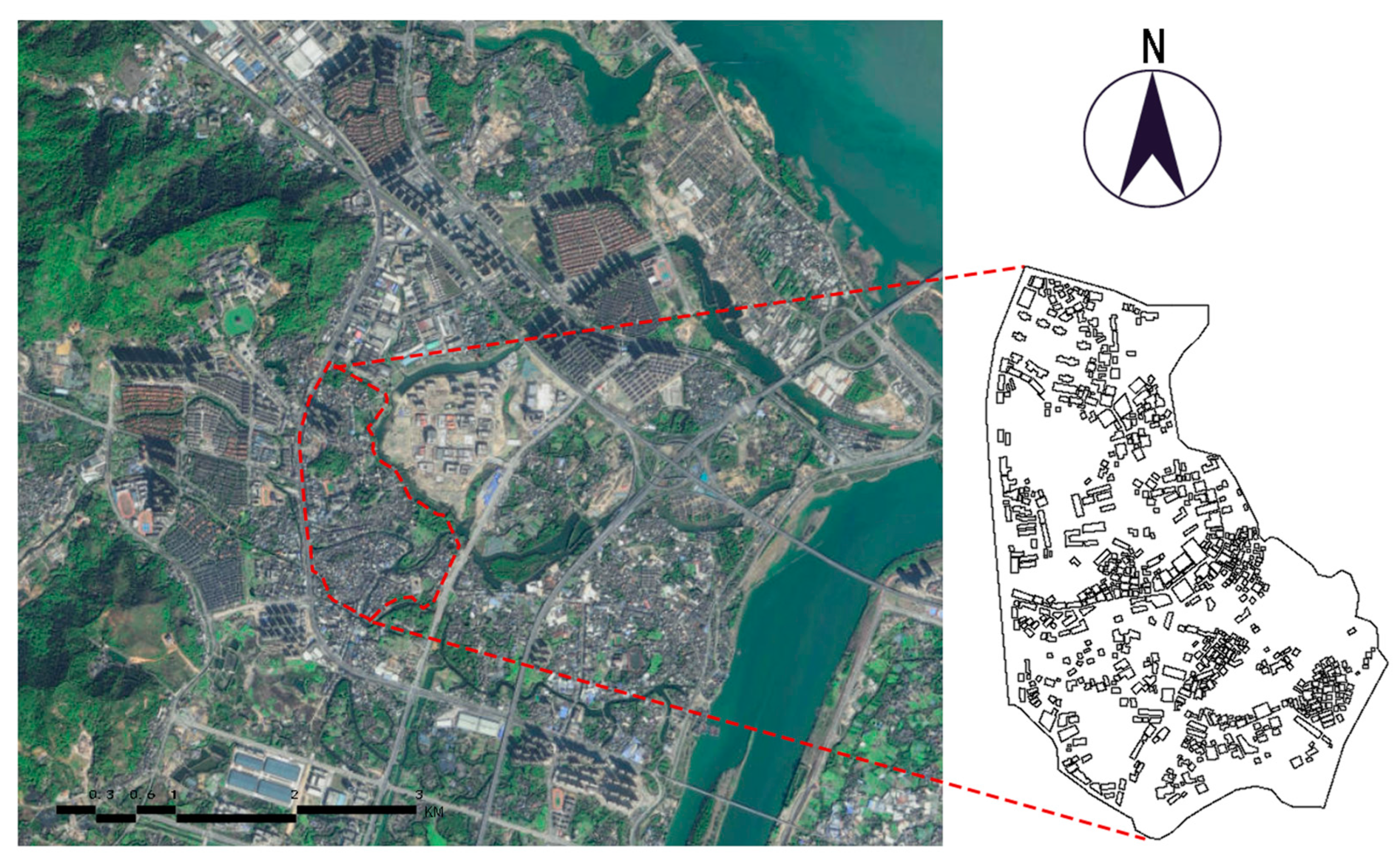
Fuzhou is ranked among the second batch of China’s nationally recognized historical and cultural cities, with a rich history and profound cultural heritage (Figure 1a). The city’s founding over 2200 years ago gave rise to the Min capital culture, as exemplified by sites such as Tanshishan, Sanfangqixiang, Funanzheng, and Shoushan stone. In 2010, Nanyu Town was designated as part of the fourth batch of famous historical towns in Fujian Province, and the ShuiXiLin District was selected as a provincial-level cultural heritage unit in the eighth batch in February 2013. The district contains numerous cultural heritage protection units, historical buildings with traditional styles, as well as elements such as pagodas and piers.
Located in the cultural heart of Fuzhou’s renowned historical city, the district is centrally situated in Nanyu Town, south of Minhou County, Fuzhou City, Fujian Province (Figure 1b). The ShuiXiLin street layout meanders from northwest to southeast, with numerous alleys branching perpendicularly from the main street (Figure 1c). The main street spans approximately 4 m in width, stretching from the summit of Dacheng to Jiaofu Palace. Ancient Ming Dynasty buildings line the historic street, extending on both sides and forming an alley system that unfolds along the southeastern base of Taiping Mountain, fanning out towards Jinxi. The mountains surround the houses with water at the back of them, creating a unified layout that integrates natural and human elements—a typical example of Ming and Qing official residence complexes in the Fuzhou area.
Distinct from other historic districts, the ShuiXiLin Historic District is characterized by its unique “half-side street” layout. This layout features historical buildings occupying one half of the space, while the other half is seamlessly integrated with the natural environment [34]. The ShuiXiLin Historic District offers a harmonious blend of rich historical architectural character and abundant natural resources. However, statistical analysis of network survey data categorizes ShuiXiLin Ancient Town as an under-represented site within Fuzhou City’s broader tourism landscape. Tourist reviews suggest that the restoration of the ShuiXiLin architectural complex has resulted in an overly polished appearance, which some feel lacks the authentic patina of historical aging. Additionally, the internal spaces of the buildings are perceived as insufficiently open, limiting opportunities for exploration and engagement, ultimately detracting from the overall tourist experience. Based on field investigations, it was found that the spatial vitality of the ShuiXiLin Historic District is relatively low, especially in the area surrounding the ShuiXiLin historic buildings. This part of the district lacks sufficient appeal to external visitors, resulting in limited foot traffic and a diminished sense of vitality. The primary cause can be attributed to the low spatial integration within the district, where the layout does not effectively connect key areas, hindering natural movement and engagement with the historical environment.
As a provincial cultural relics protection unit, the ShuiXiLin architectural complex is also a key project within the MinYue tourism area, as outlined in the Minhou County Territorial Spatial Master Plan (2021–2035). Moving forward, the ShuiXiLin Historic District holds significant potential for growth through the development of business services and tourism, while ensuring the proper protection and activation of its historical assets. By emphasizing its historical and cultural significance, the district can contribute to the region’s cultural prosperity. Overall, the ShuiXiLin Historic District offers substantial developmental potential.

3.2. Analysis of the Spatial Form of Historical District

Leveraging spatial syntax theory, this research investigates the spatial characteristics of the ShuiXiLin Historic District and assesses tourists’ spatial perceptions. The analysis is conducted in three stages: constructing a basic model, generating a spatial model, and analyzing the spatial model.
Remote sensing imagery was sourced from Map World’s website (Appendix A), and, in conjunction with Amap data (Appendix A), the contours of the study area and the road network were manually delineated. Using AutoCAD 2020, the map was converted into a base model. The finalized base model was then imported into DepthmapX (formerly UCL Depthmap) Version 10.14.00b software to generate the axial and spatial models. Space syntax analysis employs three types of distance metrics: topological (paths with the fewest turns), geometrical (paths with the least angle change), and metric (paths with the shortest physical distance) [25]. During variable analysis, key variables from the spatial syntax model were selected to examine the spatial topological relationships among the street axes in the ShuiXiLin Historic District. The key variables include connectivity value, control value, total depth, mean depth, global integration, local integration, intelligibility, and synergy [35]. The connectivity value quantifies the number of spaces linked to other spaces, calculated using the following formula:
Ci = k(i),
i represents a particular street in the system (i = 1, 2, …, n); k represents the total number of streets directly neighboring street i. Higher connectivity values indicate greater proximity to the surrounding spaces, more influence on the surrounding spaces, and better spatial permeability. The control value is the inverse sum of the connectivity values connected to other spatial nodes, as shown in the following equation:
Ctrl = j = 1 k 1 Ci ,
j (j = 1, 2, …, k) represents the streets directly neighboring i; Ci is the aforementioned connectivity value. Larger control values indicate that the space exerts a higher degree of control over the spaces it intersects. The mean depth value represents the shortest distance between a space and all other spaces. The global depth value is the sum of the mean depth values of each node. Generally, a smaller global depth value indicates that the space is located in a more accessible position within the system, while a higher value suggests that the space is deeper within the network. Both are given by the following formula:
MD i = 1 ( n 1 ) × TD i ,
TD i = j = 1 n d ij
MD i = j = 1 n d ij ( n 1 )
n represents the total number of streets; dij represents the minimum number of steps between streets i and j. A lower mean depth indicates greater accessibility, meaning a lower mean depth value is preferable. Global integration measures the degree of spatial aggregation or disaggregation between a given space and other spaces, as shown in the following formula:
INT i = n ( log 2 ( ( n 2 ) 3 ) 1 ) + 1 ( n 1 ) ( MD i )
MDi is the aforementioned mean depth value. Intelligibility measures how easily a spatial grouping is recognized. A spatial grouping with a high degree of intelligibility means its overall spatial layout is more easily understood and navigated by people, as shown in the following formula:
R I 2 = ( C i C ¯ ) ( INT i INT g ¯ ) 2 ( C i C ¯ ) ( INT i INT g ¯ ) 2
C is the average of all the connectivity values. INTg is the average of all the global integration values. Synergy describes the correlation between local and global integration in spatial layout analysis and reflects the extent to which an individual uses local spatial cognition to form an understanding of global spatial perception, as shown in the following formula:
R S 2 = [ ( INT il INT l ¯ ) ( INT ig INT g ¯ ) ] 2 ( INT il INT l ¯ ) 2 ( INT ig INT g ¯ ) 2 ,
INTil and INTl represent the local integration of street i and the mean local integration of all streets, respectively; INTig and INTg represent the global integration of street i and the mean global integration of all streets. This study employs Spearman’s rank correlation coefficient to examine the correlation between local integration and global integration, as well as between connectivity and global integration. Spearman’s rank correlation coefficient, often denoted as ρ (rho), is a non-parametric statistical method used to measure the monotonic relationship between two variables. It does not require the data to follow a normal distribution and can be applied to continuous variables, ordinal variables, or data that do not meet the normality assumption [36].
The data were obtained through the software’s axial and visual graph analysis (VGA), which quantifies and interprets the urban spatial form of the study area and evaluates the ease of perception for tourists [37].

4. Results

4.1. Connection Value, Control Value, Depth Value, Integration Analysis

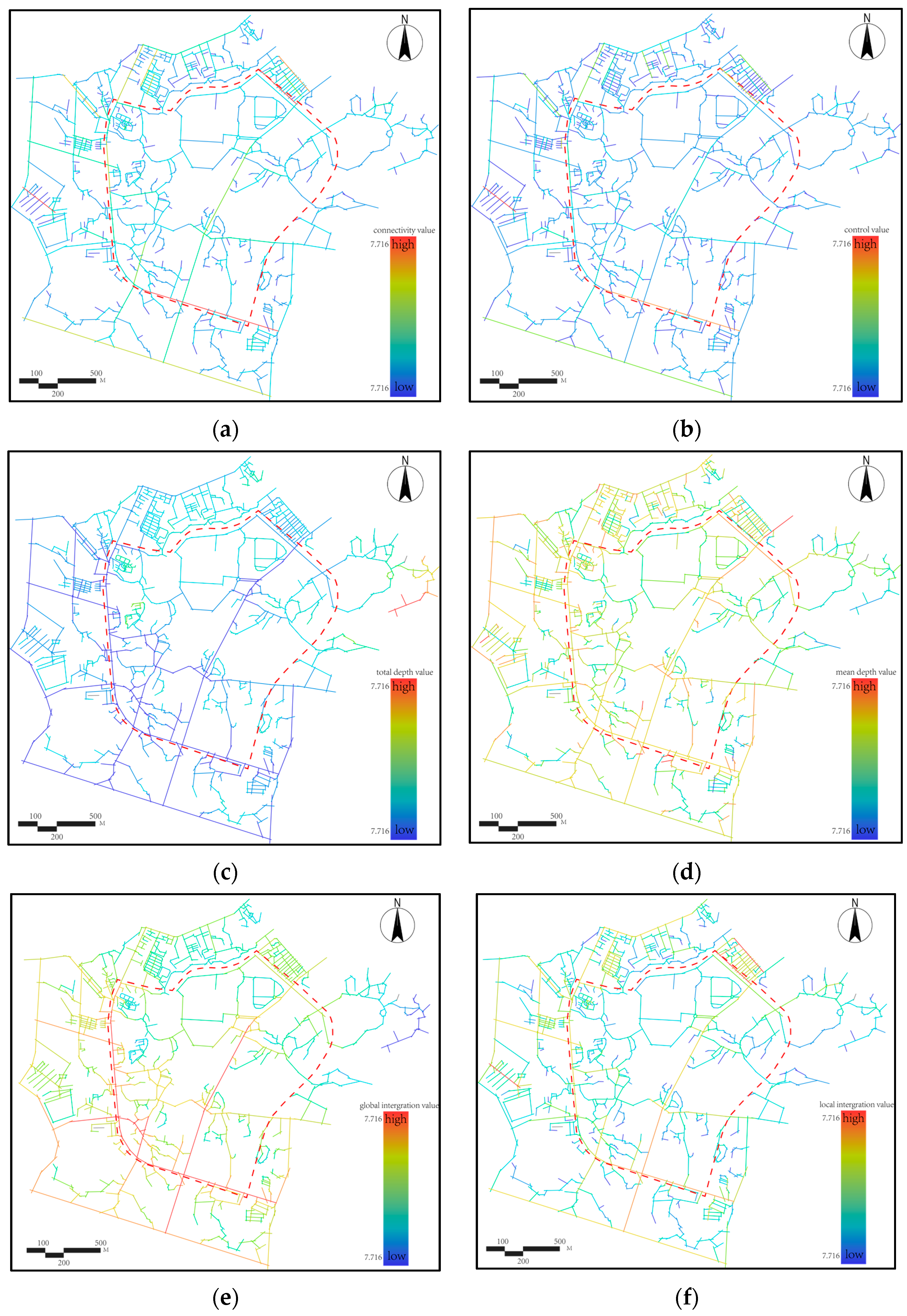
This study aims to analyze the spatial morphological characteristics of the ShuiXiLin Historic District. To mitigate boundary effects on simulation outcomes, a 500 m buffer zone was incorporated into the base model of the study area. In the spatial syntactic analysis, color coding was used to indicate value levels: redder hues represent higher values, while bluer tones correspond to lower values. Local integration measures the proximity of a node to other spatial nodes, typically within three topological distances. Global integration calculates a node’s closeness to nodes across all topological distances. Table 2 presents the spatial syntactic variables for the 13 principal blocks within the ShuiXiLin Historic District, while Figure 2 displays the results of the spatial syntactic model analysis.
Overall, the ShuiXiLin building complex constitutes a small portion of the entire district, with residential functions continuing to dominate the buildings in the area. Numerous alleys in the district are relatively enclosed or terminate in dead ends, creating “cul-de-sacs” that reduce the connectivity of the district’s internal streets.
(1)
Table 2 reveals that the overall connectivity value of the ShuiXiLin Historic District is low, ranging from 3 to 8, with the highest connectivity value of 8 observed for Road H. Roads L and M, due to their urban nature, exhibit connectivity values above the district’s average of 4.769. Additionally, Road C, which hosts the ShuiXiLin complex, has a connectivity value of 3, reflecting its three intersections with other road axes. This connectivity value is below the average, as illustrated in Figure 2a.
(2)
Table 2 demonstrates that Roads D, H, J, and L exhibit high control values. With a control value of only 1.083, Street C—home to the ShuiXiLin complex—registers the lowest value among all recorded data (Figure 2b).
(3)
The average mean depth value for the ShuiXiLin Historic District, as indicated by Table 2 (Figure 2c), is a low 2.268, suggesting the area’s road network is particularly susceptible to external pedestrian traffic. Due to its geographical setting, the street housing the ShuiXiLin complex (Street C) exhibits a depth value of 2.090, which is below the average. The global depth value for the ShuiXiLin complex is 16.347, higher than the mean value of 12.228. This also indicates that the space of the ShuiXiLin complex is relatively more difficult to access (Figure 2d).
(4)
Figure 2e,f indicate that Roads D and H, excluding the urban arterials, Roads L and M, excel in local integration. Commercial and restaurant establishments are located along these roads, and a food market on the north side of Road H attracts significant pedestrian traffic. Building on previous analysis, Streets D and H exhibit above-average connectivity (46.7% and 67.7%, respectively), control (47.8% and 48.7%), global integration (4% and 23.3%), and local integration (17% and 33.4%). Data presented in Table 2 suggest that Roads D and H could become the district’s core and main axes. In contrast, Street C, which houses the ShuiXiLin complex, falls below average in connectivity, control, and both local and global integration, indicating a lower likelihood of attracting external visitors. A macroscopic view reveals that the ShuiXiLin Historical District’s average local integration (1.726) significantly surpasses its global integration (0.655). This comparison underscores the district’s isolated development pattern, highlighting the need for improved internal road accessibility and optimized transportation facilities. As key spatial corridors, Streets D and H naturally draw significant footfall. However, the outlook for Street C, the site of the ShuiXiLin complex, is less favorable. Satellite imagery and field research indicate the ShuiXiLin complex’s natural isolation by mountains and water. Furthermore, the sparse urban roads leading to the ShuiXiLin Historic District force visitors to navigate a narrow 500 m path, exposing spatial accessibility and convenience issues. Moreover, the considerable depth of Street C challenges pedestrian flow, hindering effective traffic management and accentuating the ShuiXiLin complex’s transport disadvantages.

4.2. Intelligibility and Synergy Analysis

The axial analysis of spatial syntax began with a correlation analysis between connectivity and global integration, as well as between local and global integration. The results revealed significant positive correlations for both data sets. However, further research indicated that the ShuiXiLin Historic District performs poorly in terms of intelligibility and internal space synergy. Specifically, the district’s synergy, with a correlation coefficient of only 0.072 between global and local integration, falls well below the critical threshold of 0.5. This suggests a weak correlation between the district’s local and global street spaces, which limits the effective integration of the local into the global. Additionally, the district’s intelligibility, with a correlation coefficient of just 0.201 between global integration and connectivity, remains below the critical threshold of 0.5. This indicates challenges for visitors in comprehending the district’s global structure from its local spaces. Figure 3a,b visually highlight the internal spatial organizational issues of the ShuiXiLin Historic District, as revealed by the spatial syntactic analyses. Table 3 demonstrates that the Spearman coefficients show a significantly positive correlation between both connectivity and global integration and between local integration and global integration.

4.3. Visual Graph Analysis

Visual graph analysis (VGA) is an analytical tool commonly applied at the building or semi-urban scale. VGA aims to enhance the understanding of spatial structures by clarifying the role of visibility in defining spatial relationships. Specifically, this method reveals visual interconnections among spatial elements, providing a scientific foundation for spatial planning and design [38].
The VGA analysis in this study focuses on a district that includes the ShuiXiLin complex area, as shown in Figure 4. Notably, the eastern side of the ShuiXiLin district is obstructed by a natural water system, with Fuyao University of Science and Technology located on the opposite side of the waterway. Additionally, the eastern side of the district is bisected by city roads, leading to the exclusion of these areas from the VGA analysis.
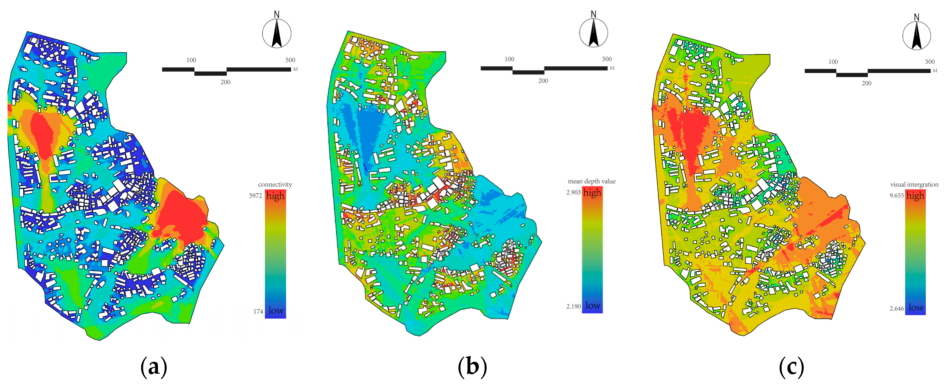
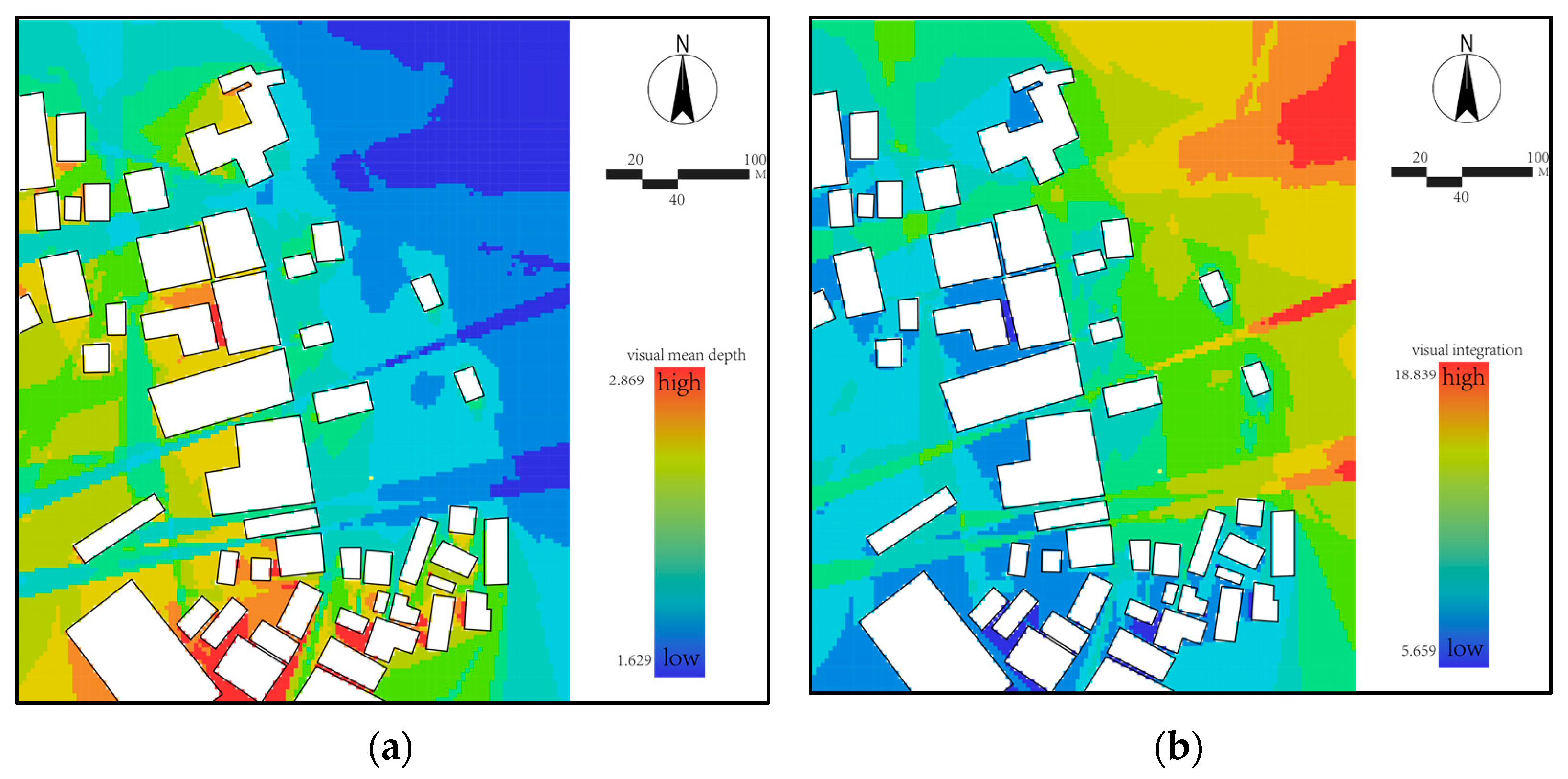
The degree of visual integration reflects observable locations [39]. A comprehensive analysis of agent robot simulation data, average visual depth, and visual integration degree reveals that, in the absence of external interference, high values (indicated by red areas) are predominantly concentrated on the northwest and southeast sides of the study area. These regions typically feature less building coverage and greater spatial openness, as exemplified by the expansive hill and waterfront open spaces. In contrast, low values (indicated by blue areas) are primarily found within the streets, suggesting that areas with denser building configurations tend to exhibit lower pedestrian traffic, as illustrated in Figure 5a.
The average visual depth and visual integration of the ShuiXiLin Historic District remain above the study area’s mean. This can be attributed to the presence of an activity plaza within the street, which effectively reduces the district’s visual depth and significantly enhances visual integration, as shown in Figure 5b,c.
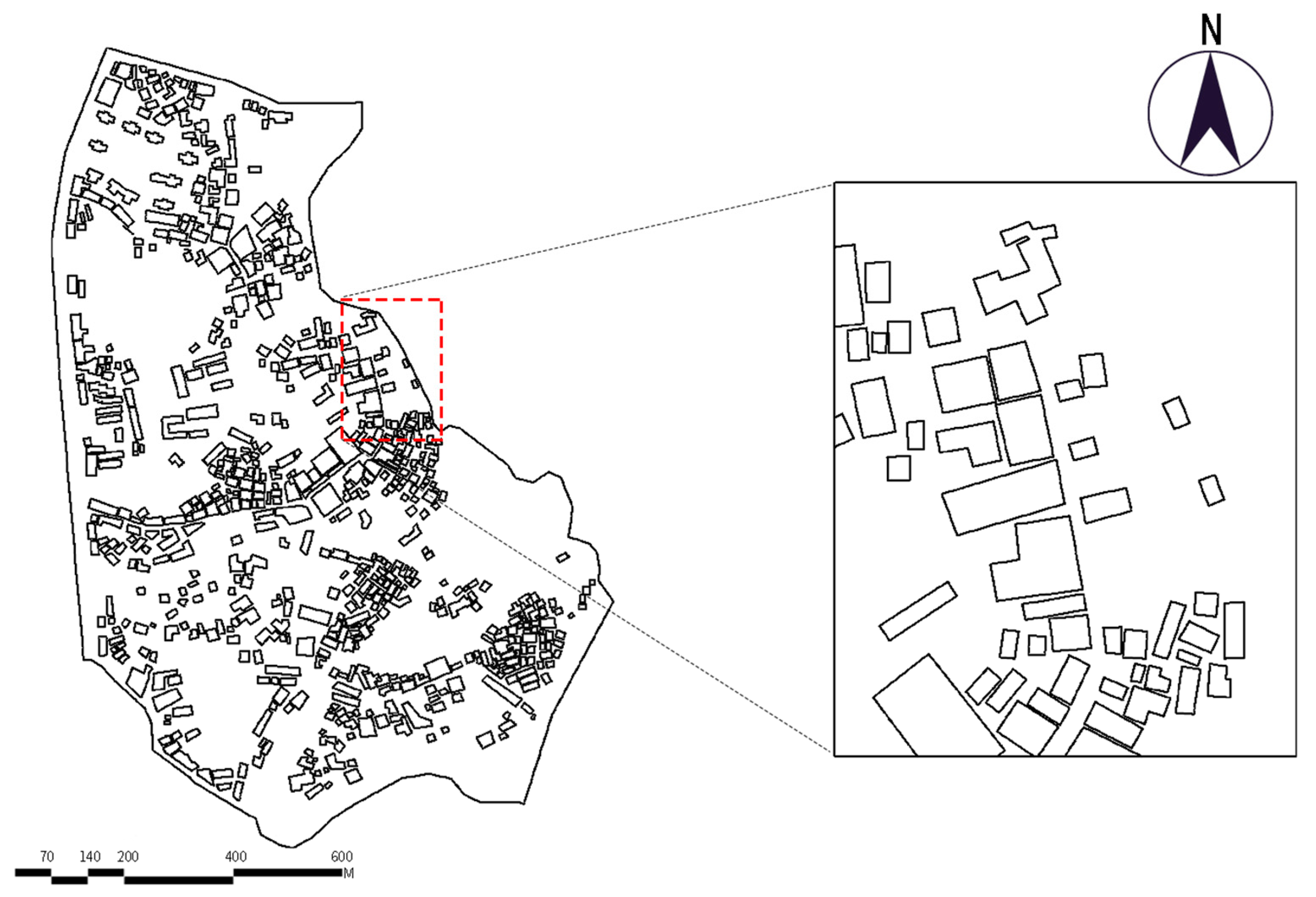
A focused analysis was conducted on the buildings surrounding the ShuiXiLin complex (Figure 6). The area’s visual depth registers low values, primarily due to minimal building shading on the east side—adjacent to the water system—and the presence of the activity plaza. In contrast, visual integration achieves high values, with both metrics concentrated on the east side. Additionally, the northern entrance exhibits lower visual depth and higher visual integration compared to the southern entrance, suggesting that entry from the north offers a superior visual experience and spatial perception. In conclusion, the north side emerges as the preferred main pedestrian entrance to the street, as shown in Figure 7a,b.

5. Discussion

In response to the existing issues in the ShuiXiLin Historic District, this study proposes three strategies, as shown in Figure 8. The following will provide a detailed explanation of the rationale behind these three strategies, their potential impacts, and the challenges that may arise during implementation.

5.1. Enhancing Connectivity Positively Influences the Public Experience Within the ShuiXiLin Historic District

This study utilizes spatial syntax to examine the morphological characteristics of the ShuiXiLin Historic District, effectively identifying factors that contribute to the area’s spatial vitality [40]. The spatial syntax analysis reveals that the district experiences relatively low internal road passability, with a notable presence of cul-de-sacs. Based on field investigation findings, the contributing factors include the following: 1. The presence of a water system and a relatively enclosed campus to the east of the ShuiXiLin historical complex; 2. a large mountainous area on the western side that isolates the ShuiXiLin buildings from the city’s main roads; 3. a dense clustering of buildings within the district and narrow streets. Research by AA Hamad, E. Ismaeel, et al. suggests that such spatial characteristics could potentially reduce the district’s vitality [41]. Therefore, developing pathways to ensure the continuous flow of public space, along with enhancing both physical and visual connectivity through short, direct corridors and multidirectional links, could contribute to significantly improving street accessibility and vitality [42]. Additionally, the district’s overall connectivity value remains relatively low, indicating that the layout does not provide clear sightlines to other streets, which may lead to a more enclosed spatial experience. Addressing these issues could positively impact residents’ well-being, enhance user experience, and foster the district’s vibrancy [43]. Transforming the green spaces along the waterfront into leisure walkways and establishing connections to the city’s main roads (Figure 8) could further activate these areas. Enhancing the district’s connectivity and the quality of public spaces can improve the daily life of residents. Increased access to green spaces, better pedestrian infrastructure, and safer, more vibrant streets can foster a greater sense of community and well-being.

5.2. Enhancing the Primary Axis of the Historic District’s Space Amplifies Its Influence Throughout the Area

Within the ShuiXiLin Historic District, the ShuiXiLin complex, rich in historical features, serves as the core of the area, significantly influencing the district’s overall vitality. However, the district’s reduced control value limits its influence, while diminished external connections hinder the flow of economic and informational exchanges, further limiting the vitality of the core space. Reconfiguring the core space to enhance its peripheral control could strengthen these external connections and improve overall vitality [39]. Moreover, as shown in Figure 8, integrating spatial analysis to define the ridge line of the historic and cultural district allows for the addition of public plazas or gathering spaces along two streets, which could serve as key axes of the district. Establishing dedicated pedestrian and bicycle lanes, along with additional parking spaces for motor vehicles and bicycles, would enhance the visual integration of the core area. By incorporating concentrated commercial and public service functions, foot traffic could be increased, thus promoting community interaction [44]. Strengthening the main axis and creating new spaces for commercial and public services could stimulate local businesses, increase foot traffic, and provide more opportunities for entrepreneurs. This could foster a more sustainable and diversified economy in the district. The area northeast of the ShuiXiLin Historic District is more open compared to its interior. Additionally, the limited local visibility and concentrated pedestrian flow within the district highlight the need to strengthen the main axis. The district’s northern side, with its lower visual depth and higher visual integration, offers an ideal entry point for pedestrians, underscoring the importance of enhancing the northern entrance and main axis in revitalization efforts [45]. Furthermore, the district faces challenges related to localized spaces within internal streets, which struggle to integrate into the broader urban fabric. These issues extend beyond spatial configurations to include public transportation access, service facilities, and the perception of the district’s boundaries. Addressing these challenges requires a more comprehensive, organic regeneration strategy that integrates the district’s spaces and facilities. Reinforcing the main axis and extending its influence to surrounding areas will positively impact the lives of residents both within and beyond the district [46].

5.3. Implementing Protective Reuse of Historical Buildings and Improving Service Facilities Can Significantly Enhance the District’s Vitality

The ShuiXiLin Historical and Cultural District is home to six Ming Dynasty buildings. Although these historical structures have undergone preservation and restoration efforts, they face challenges such as limited external interaction and a relatively enclosed environment. To invigorate the district, it is essential to reinforce the primary axes and enhance their permeability to adjacent spaces. The unique characteristics of the historic building clusters require a multifaceted approach to this strategy [47], adding complexity to the revitalization process. Additionally, the ShuiXiLin district currently lacks essential service facilities, which detracts from the visitor experience. To address this, specific measures can be implemented to activate the six Ming Dynasty buildings by introducing functions such as commercial activities, exhibitions, and cultural spaces. For example, establishing museums focused on history or local culture could highlight the district’s heritage, generate economic benefits, and attract more visitors. Improving the physical environment, including the adaptive reuse of historic buildings and the creation of vibrant public spaces, could lead to an increase in property values within the district. Real estate developers and local businesses may view these improvements as investment opportunities, thus promoting the redevelopment of the area. The introduction of museums and cultural spaces can help educate both locals and visitors about the district’s rich history. This can foster greater cultural pride among residents and contribute to the broader public’s understanding and appreciation of the area’s significance. Moreover, pedestrian infrastructure should be enhanced, and a public transportation network linking the district to the city center should be developed. Establishing transport hubs near the district could improve traffic flow and guide visitors more efficiently. Additionally, incorporating tourism amenities such as visitor information centers and public restrooms would enhance the overall experience. Multi-functional plazas, open-air cafés, and accommodations that complement the district’s historical character could further promote tourism while preserving its cultural atmosphere. Enhancing the landscape while maintaining the district’s spatial integrity will help meet its evolving needs. Furthermore, public participation in the development and implementation of a sustainable public transportation system is essential to ensuring long-term success [48].

6. Conclusions

This study applies spatial syntax theory and analytical tools to delineate the spatial morphology of Fuzhou’s ShuiXiLin Historical District. Key indicators of spatial form are extracted, and potential factors influencing the district’s vitality are identified. The current spatial configuration of the district’s core and surrounding areas is systematically organized, with an assessment of the district’s spatial characteristics and condition. By integrating spatial syntax theory with existing research, the study proposes strategies to enhance the district’s vitality through a multi-faceted approach. The paper is structured into three main sections. First, it defines the spatial form of the ShuiXiLin Historical District and explains the associated variables. Spatial syntax software (DepthmapX (formerly UCL Depthmap) Version 10.14.00b)) simulates the district’s topological relationships, and synergy and intelligibility metrics are used to assess its spatial attributes. Second, visibility graph analysis (VGA) is applied to the street area around the ShuiXiLin historical buildings to identify potential focal points. Finally, the paper presents a revitalization strategy for the district. The study concludes the following: (1) Enhancing connectivity positively impacts the public experience within the ShuiXiLin Historic District; (2) strengthening the district’s primary axis amplifies its influence across the area; and (3) implementing protective reuse of historical buildings and improving service facilities can significantly enhance the district’s vitality.
The strategies proposed in this study also offer valuable insights for other countries and regions. Reza Askarizad and Jinliao He, through their research on the historical districts in Rasht, Iran, suggested that urban governance should particularly focus on the overall structure of the urban grid system, and that planning strategies should integrate the city’s most prominent landmarks with the city’s high-rise locations [49]. Ayşe Sema KUBAT et al., in their study of Sharjah’s heritage area, proposed strategies for re-creating and strengthening the continuity of waterfront streets between the heritage area and the waterfront zone, thereby increasing the vitality of the center. They also suggested transforming selected local axes into a larger-scale street network, connecting the heritage area to other parts of the city, and promoting active land uses (such as services, accommodation, and entertainment) to preserve the vitality of the heritage area [50]. The strategies proposed by these scholars are similar to those put forward in this study, but the strategies in this study are more targeted. While spatial syntax tools were employed in this study for simulation and analysis, they do not fully capture the subjective spatial perceptions and experiences of tourists. At the same time, the strategies mentioned above may encounter obstacles during implementation. Firstly, balancing the preservation of historic buildings with the need for modernization and new infrastructure could present challenges. Some stakeholders may resist changes that they perceive as damaging to the authenticity of the historic district. Negotiating between conservationists and developers will be crucial to ensuring a sustainable approach. Secondly, while revitalization strategies may be seen as beneficial for tourism and the economy, some residents may fear displacement or loss of local character. There may be concerns that commercialization could change the cultural landscape and erode the district’s identity. Engaging the local community in the planning process and ensuring that the benefits of revitalization are felt by all could mitigate these concerns. Lastly, improving accessibility within the district, particularly for people with disabilities or those who rely on public transportation, would make the area more inclusive. By improving transportation networks and providing amenities like information centers and public restrooms, the district would become more accessible to people from various social backgrounds. A comparative analysis between survey findings and spatial syntax results is crucial, with any discrepancies explored through field observations, questionnaires, and interviews. Additionally, it would be beneficial to compare and analyze other historic districts to identify differences from various perspectives, such as architectural scale, stylistic features, and historical and cultural contexts. In addition, artificial intelligence (AI) can be employed to assist space syntax in data collection and analysis. By utilizing smart sensors, satellite remote sensing, social media, and other channels, vast amounts of spatial usage data, such as crowd movement and space utilization frequency, can be gathered. This data can provide richer and more dynamic insights for spatial syntax analysis. For example, AI can help analyze behavioral patterns under different time periods and spatial layouts, thereby revealing the relationship between spatial configuration and human behavior.
Overall, the study employs spatial syntax analysis to enhance the spatial appeal of historic districts, contributing to the growth of the cultural heritage tourism sector. The methodology developed is specifically tailored for application within the ShuiXiLin Historic District. Based on the analysis, targeted strategies are proposed to improve tourists’ spatial experiences within the district. Furthermore, by quantifying and assessing the differences between the ShuiXiLin Historic District and the core area of Nanyu Town, this study facilitates the revitalization of ShuiXiLin and strengthens its role in preserving Nanyu Town’s historical heritage.

Author Contributions

Conceptualization, J.-M.F.; Methodology, J.-M.F.; Software, Y.-F.T.; Formal Analysis, Z.-G.W. and Y.-K.Z.; Investigation, J.-M.F. and Y.-F.T.; Data Curation, Y.-K.Z.; Writing—Original Draft Preparation, J.-M.F. and L.-Y.F.; Writing—Review and Editing, L.-Y.F.; Supervision, Z.-G.W. All authors have read and agreed to the published version of the manuscript.

Funding

This research was supported by the Science and Technology Project of Huadong Engineering (Fujian) Corporation limited (ZKY2021-FJ-02-04).

Data Availability Statement

The data presented in this study are available on request from the corresponding author due to privacy restrictions.

Conflicts of Interest

Author Jian-Ming Fu was affiliated to the company Architecture & Public Transportation Design Institute Huadong Engineering (Fujian) Corporation Limited. For the authors, Jian-Ming Fu and Yi-Fan Tang, the research is part of their studies in Fuzhou University and does not involve data correlation with their current affiliated companies.

Appendix A

https://www.tianditu.gov.cn/?4, accessed on 15 February 2025.
https://ditu.amap.com/, accessed on 15 February 2025.

References

  1. Landorf, C. Managing for sustainable tourism: A review of six cultural World Heritage Sites. J. Sustain. Tour. 2009, 17, 53–70. [Google Scholar] [CrossRef]
  2. Wu, C.; Li, G.; Li, Y.; Pu, Y.; Zhang, Y. A Review of Research on Strategies and Methods for the Revitalization of Urban Historic Districts. IOP Conf. Ser. Earth Environ. Sci. 2022, 1101, 052021. [Google Scholar] [CrossRef]
  3. Huang, Q.L.; Deng, L.L.; Yang, S.H. Renovation design of historical districts based on cultural and tourism integration—Taking Zhenjiang Xinhe Street as an example. Design 2023, 8, 1840–1848. [Google Scholar] [CrossRef]
  4. Corbusier, L.; Eardley, A. The Athens Charter; Grossman Publishers: New York, NY, USA, 1973. [Google Scholar]
  5. Zhao, P.; Md Ali, Z.; Nik Hashim, N.H.; Ahmad, Y.; Wang, H. Evaluating social sustainability of urban regeneration in historic urban areas in China: The case of Xi’an. J. Environ. Manag. 2024, 370, 122520. [Google Scholar] [CrossRef] [PubMed]
  6. Duan, J.; Lan, W.; Jiang, Y. An evaluation approach to spatial identity in historic urban areas from a humanistic perspective. Front. Archit. Res. 2022, 11, 806–814. [Google Scholar] [CrossRef]
  7. Zhang, Y.; Dong, W. Determining Minimum Intervention in the Preservation of Heritage Buildings. Int. J. Archit. Herit. 2019, 15, 698–712. [Google Scholar] [CrossRef]
  8. Fusco Girard, L. Toward a Smart Sustainable Development of Port Cities/Areas: The Role of the “Historic Urban Landscape” Approach. Sustainability 2013, 5, 4329–4348. [Google Scholar] [CrossRef]
  9. Shang, W.; He, C.; Lv, S. Sustainable Renewal of Spontaneous Spatial Characteristics of a Historical–Cultural District: A Case Study of Tanhualin, Wuhan, China. Sustainability 2023, 15, 2038. [Google Scholar] [CrossRef]
  10. Hassan, O.; Mohamed, E.A.; Hassan, A.; Shaheen, M.; Bekheet, W. Sustainable urban development of mobility and streetscape in historic city quarters, an ancient street in Alexandria—Egypt, as a case study. Alex. Eng. J. 2023, 78, 378–389. [Google Scholar] [CrossRef]
  11. Hu, C.; Gong, C. Exploring the creation of ecological historic district through comparing and analyzing four typical revitalized historic districts. Energy Procedia 2017, 115, 308–320. [Google Scholar] [CrossRef]
  12. Lin, Y.H.; Chen, C.L. The Service Experience Innovation Model of Cultural Tourism in Historic Districts: A Case Study on Zhongshan Road in Quanzhou, Fujian Province of China. Sustainability 2024, 16, 3567. [Google Scholar] [CrossRef]
  13. Jia, M.; Feng, J.; Chen, Y.; Zhao, C. Visual Analysis of Social Media Data on Experiences at a World Heritage Tourist Destination: Historic Centre of Macau. Buildings 2024, 14, 2188. [Google Scholar] [CrossRef]
  14. Huang, Y.; Zhang, Z.; Fei, J.; Chen, X. Optimization Strategies of Commercial Layout of Traditional Villages Based on Space Syntax and Space Resistance Model: A Case Study of Anhui Longchuan Village in China. Buildings 2023, 13, 1016. [Google Scholar] [CrossRef]
  15. Lin, H.; Hong, X.-C.; Wen, C.; Hu, F. The historical sensing of urban forest based on the indicators of CES and landscape categories: A case of Kushan scenic area in CHINA. Ecol. Indic. 2024, 166, 112440. [Google Scholar] [CrossRef]
  16. Feng, L.; Wang, J.; Liu, B.; Hu, F.; Hong, X.; Wang, W. Does Urban Green Space Patern Affect Green Space Noise Reduction? Forests 2024, 15, 1719. [Google Scholar] [CrossRef]
  17. Ren, W.; Lu, P.; Wang, Y.; Hong, X.-C. Understanding the association between urban noise and nightime light in China. Sci. Rep. 2024, 14, 31472. [Google Scholar] [CrossRef] [PubMed]
  18. Lin, H.; Wen, H.; Zhang, D.-Y.; Yang, L.; Hong, X.-C.; Wen, C. How Social Media Data Mirror Spatio-Temporal Behavioral Pattemnsof Tourists in Urban Forests: A Case Study of Kushan Scenic Area in Fuzhou, China. Forests 2024, 15, 1016. [Google Scholar] [CrossRef]
  19. Lin, H.; Wang, J.-B.; Zhang, X.; Hu, F.; Liu, J.; Hong, X.-C. Historical sensing: The spatial pattern of soundscape occurrencesrecorded in poems between the Tang and the Oing Dynasties amid trbanization. Humanit. Soc. Sci. Commun. 2024, 11, 730. [Google Scholar] [CrossRef]
  20. Yang, L.; Jin, Q.; Fu, F. Research on Urban Street Network Structure Based on Spatial Syntax and POI Data. Sustainability 2024, 16, 1757. [Google Scholar] [CrossRef]
  21. Vukonić, B.; Tkalac, D. Tourism and urban revitalization a case study of Poreč, Yugoslavia. Ann. Tour. Res. 1984, 11, 591–605. [Google Scholar] [CrossRef]
  22. Turner, A. From axial to road-centre lines: A new representation for space syntax and a new model of route choice for transport network analysis. Environ. Plan. B Plan. Design 2007, 34, 539–555. [Google Scholar] [CrossRef]
  23. Wang, Y.; Xiu, C. Spatial Quality Evaluation of Historical Blocks Based on Street View Image Data: A Case Study of the Fangcheng District. Buildings 2023, 13, 1612. [Google Scholar] [CrossRef]
  24. Hillier, B. Space is the Machine: A Configurational Theory of Architecture; Cambridge University Press: Cambridge, UK, 1996. [Google Scholar]
  25. Turner, A.; Penn, A.; Hillier, B. An algorithmic definition of the axial map. Environ. Plan. B Plan. Des. 2005, 32, 425–444. [Google Scholar] [CrossRef]
  26. Ge, Y.; Gan, Q.; Ma, Y.; Guo, Y.; Chen, S.; Wang, Y. Spatial Vitality Detection and Evaluation in Zhengzhou’s Main Urban Area. Buildings 2024, 14, 3648. [Google Scholar] [CrossRef]
  27. Sun, Y.; Zhan, H.; Gao, C.; Li, H.; Guo, X. Spatial Syntactic Analysis and Revitalization Strategies for Rural Settlements in Ethnic Minority Areas: A Case Study of Shuanglang Town, China. Buildings 2024, 14, 2531. [Google Scholar] [CrossRef]
  28. Şahin Körmeçli, P. Accessibility of Urban Tourism in Historical Areas: Analysis of UNESCO World Heritage Sites in Safranbolu. Sustainability 2024, 16, 2485. [Google Scholar] [CrossRef]
  29. Luo, Y.; Lin, Z. Spatial Accessibility Analysis and Optimization Simulation of Urban Riverfront Space Based on Space Syntax and POIs: A Case Study of Songxi County, China. Sustainability 2023, 15, 14929. [Google Scholar] [CrossRef]
  30. Huang, Z.; Wang, B.; Luo, S.; Wang, M.; Miao, J.; Jia, Q. Integrating Streetscape Images, Machine Learning, and Space Syntax to Enhance Walkability: A Case Study of Seongbuk District, Seoul. Land 2024, 13, 1591. [Google Scholar] [CrossRef]
  31. Qin, X.; Du, X.; Wang, Y.; Liu, L. Spatial Evolution Analysis and Spatial Optimization Strategy of Rural Tourism Based on Spatial Syntax Model—A Case Study of Matao Village in Shandong Province, China. Land 2023, 12, 317. [Google Scholar] [CrossRef]
  32. Guo, K.; Cao, Y. Application of planning evaluation of historical block based on space syntax—Case study: Third Streets and Two Alleys historical block, Nanning. IOP Conf. Ser. Earth Environ. Sci. 2021, 768, 012139. [Google Scholar] [CrossRef]
  33. Chen, J.; Chen, Y. Analysis and Research on Spatial Nodes of Historical Villages based on Spatial Syntax Theory: Cuiwei Village in Qianshan Area of Zhuhai as an Example. J. Comput. Sci. Technol. Stud. 2022, 4, 07–34. [Google Scholar] [CrossRef]
  34. Chen, L.; Chen, G.; Guan, R. Public Space Improvement Strategy of Shuixilin Historic District in Fuzhou Based on Restorative Environmental Theory. Huazhong Archit. 2023, 41. [Google Scholar] [CrossRef]
  35. Lyu, Y.; Abd Malek, M.I.; Ja‘afar, N.H.; Sima, Y.; Han, Z.; Liu, Z. Unveiling the potential of space syntax approach for revitalizing historic urban areas: A case study of Yushan Historic District, China. Front. Archit. Res. 2023, 12, 1144–1156. [Google Scholar] [CrossRef]
  36. Spearman, C. The proof and measurement of association between two things. Am. J. Psychol. 1904, 15, 72–101. [Google Scholar] [CrossRef]
  37. Xu, Y.; Rollo, J.; Jones, D.S.; Esteban, Y.; Tong, H.; Mu, Q. Towards Sustainable Heritage Tourism: A Space Syntax-Based Analysis Method to Improve Tourists’ Spatial Cognition in Chinese Historic Districts. Buildings 2020, 10, 29. [Google Scholar] [CrossRef]
  38. Noyman, A.; Doorley, R.; Xiong, Z.; Alonso, L.; Grignard, A.; Larson, K. Reversed urbanism: Inferring urban performance through behavioral patterns in temporal telecom data. Environ. Plan. B Urban Anal. City Sci 2019, 46, 1480–1498. [Google Scholar] [CrossRef]
  39. Huang, J.; Hu, X.; Wang, J.; Lu, A. How Diversity and Accessibility Affect Street Vitality in Historic Districts? Land 2023, 12, 219. [Google Scholar] [CrossRef]
  40. Wen, Z.; Zhao, J.; Li, M. A Study on the Influencing Factors of the Vitality of Street Corner Spaces in Historic Districts: The Case of Shanghai Bund Historic District. Buildings 2024, 14, 2947. [Google Scholar] [CrossRef]
  41. Hamad, A.A.; Ismaeel, E. Accessibility and Connectivity for Enhancement the Integrative Conservation of the Historic Urban Fabric of Mosul Old City. Diyala J. Eng. Sci. 2023, 16, 68–78. [Google Scholar] [CrossRef]
  42. Ozkan, D.Y.; Cekmis, A. The Impact of Passages on Street Connectivity in Commercial Areas: The case of Besiktas market area in Istanbul. ACE Archit. City Environ. 2024, 18, 12088. [Google Scholar] [CrossRef]
  43. Zarin, S.Z.; Niroomand, M.; Heidari, A.A. Physical and Social Aspects of Vitality Case Study: Traditional Street and Modern Street in Tehran. Procedia—Soc. Behav. Sci. 2015, 170, 659–668. [Google Scholar] [CrossRef]
  44. Zhang, N. A Preliminary Study of Slow Traffic System to Activate the Vitality of Historic Districts Take Wuhan Tanhualin Historic District as an example. IOP Conf. Ser. Earth Environ. Sci. 2021, 647, 012206. [Google Scholar] [CrossRef]
  45. Fang, Y.N.; Zeng, J.; Namaiti, A. Landscape Visual Sensitivity Assessment of Historic Districts—A Case Study of Wudadao Historic District in Tianjin, China. ISPRS Int. J. Geo-Inf 2021, 10, 175. [Google Scholar] [CrossRef]
  46. Wei, Y.; Yuan, H.; Li, H. Exploring the Contribution of Advanced Systems in Smart City Development for the Regeneration of Urban Industrial Heritage. Buildings 2024, 14, 583. [Google Scholar] [CrossRef]
  47. Liang, K.; Zou, Y.; Li, G. Spatiotemporal Evaluation of the Coupling Relationship between Public Service Facilities and Population: A Case Study of Wuhan Metropolitan Area, Central China. Sustainability 2024, 16, 7698. [Google Scholar] [CrossRef]
  48. Papagiannakis, A.; Tsami, M. Enhance Accessibility in Traditional Districts a Case Study of the “Upper Town” of Thessaloniki. Procedia—Soc. Behav. Sci. 2012, 48, 3317–3327. [Google Scholar] [CrossRef]
  49. Askarizad, R.; He, J. Perception of Spatial Legibility and Its Association with Human Mobility Patterns: An Empirical Assessment of the Historical Districts in Rasht. Iran. Int. J. Environ. Res. Public Health 2022, 19, 15258. [Google Scholar] [CrossRef] [PubMed]
  50. Kubat, A.; Rab, S.; Guney, Y.; Ozer, O.; Kaya, S. Application of space syntax in developing a regeneration framework for Sharjah’s heritage area. In Proceedings of the 8th International Space Syntax Symposium, Santiago, Chile, 3–6 January 2012. [Google Scholar]
Figure 1. Study area notes: The research area is located in the core area of Nanyu Town, Fuzhou: (a) Location map of Fuzhou; (b) scope of research subjects; (c) the ShuiXiLin Historic District major road numbers.
Buildings 15 00657 g001
Figure 2. The space syntax model analysis result on the core area of Nanyu Town: (a) connectivity value; (b) control value; (c) total depth value; (d) mean depth value; (e) global integration value; (f) local integration value.
Buildings 15 00657 g002
Figure 3. The space syntax model analysis results on the core area of Nanyu Town: intelligibility value: (a) scatter plot of axial intelligibility; (b) scatter plot of axial synergy.
Buildings 15 00657 g003
Figure 4. The current situation map of ShuiXiLin.
Buildings 15 00657 g004
Figure 5. An analysis of agent robotics and visualization of ShuiXiLin and its surrounding streets: (a) agent connectivity; (b) visual mean depth; (c) visual integration.
Buildings 15 00657 g005
Figure 6. Location of the ShuiXiLin historical complex.
Buildings 15 00657 g006
Figure 7. Visibility graph analysis of the ShuiXiLin historical complex: (a) visual mean depth; (b) visual integration.
Buildings 15 00657 g007
Figure 8. Spatial revitalization strategies for ShuiXiLin Historic District.
Buildings 15 00657 g008
Table 1. The economic and social benefits of historic districts.
The Economic and Social Benefits of Historic Districts
Economic BenefitsStimulate economic development within its boundaries.
Address the financial challenges of preservation, promote local economic growth, and improve residents’ living standards.
Create a favorable investment environment in surrounding areas, potentially increasing land values and enhancing economic vitality and competitiveness.
Social BenefitsEnsure the continuation or revival of cultural life at risk of decline, thereby preserving cultural diversity and societal identity.
Table 2. The spatial variables of thirteen major streets in the ShuiXiLin Historic District.
Street NameConnectivity ValueControl ValueTotal
Depth
Value
Mean Depth ValueGlobal Integration ValueLocal Integration Value
A31.58315.1032.3120.5301.393
B31.83314.8962.2270.5031.222
C31.08317.8572.0900.4431.305
D72.75011.8822.4290.6872.020
E51.70012.2982.2850.6621.813
F41.50013.2842.0630.6081.626
G41.66712.2752.4010.6621.198
H82.76610.2542.4850.8082.303
I51.78810.2392.3100.8071.932
J32.00014.1961.8570.6131.149
K41.66714.3472.1420.6061.480
L72.28810.5892.5050.7802.632
M61.56110.2032.3840.8122.366
Average4.7691.86012.8782.2680.6551.726
Table 3. Correlation analysis.
Spearman’s Rank Correlation Coefficient
Connectivity and Global Integration0.234 *
Global Integration and Local Integration0.436 *
* The correlation is significant at a confidence level (two-sided) of 0.01.
Disclaimer/Publisher’s Note: The statements, opinions and data contained in all publications are solely those of the individual author(s) and contributor(s) and not of MDPI and/or the editor(s). MDPI and/or the editor(s) disclaim responsibility for any injury to people or property resulting from any ideas, methods, instructions or products referred to in the content.