
Convergence, Mining, and Application: A Data Collaboration Framework for Spatial-Gene Research and Practice

Abstract
1. Introduction
2. Literature Review
2.1. Urban Planning Data Collaboration
- (1)
- Information Integration: Merging multi-source heterogeneous data to assist planners in grasping the urban development status in the form of “information sets”.
- (2)
- Workflow Optimization: Streamlining the planning practice process, reducing repetitive work and unnecessary connections among different technical links.
- (3)
- Decision Support: Integrating unified analytical viewpoints to support precise policy-making by planners and managers.
- (4)
- Collaborative Sharing: Establishing a mechanism to facilitate information exchange and collaborative work among different institutions.
2.2. Spatial Gene
- (1)
- Urban Morphology. Conzen adhered to the morphogenetic research tradition, formulated the research methodology of morphological factors, and specified the research framework and terminology of Urban Morphology [43].
- (2)
- Architectural Pattern Language. Alexander focused on the interaction between form and context, proposed 253 patterns ranging from the macro to the micro level of the city to describe the consistency between place form and activities, and indicated that the relationship pattern in space is in accordance with a certain event pattern. The creation of an architectural form requires following a rule system composed of patterns [44].
- (3)
- Building Typology. Caniggia observed the impact of the leading type on the evolution process of spatial entities, encompassing two main characteristics, namely, synchronic variations and diachronic variations, and firmly believed that by perpetuating this leading type, a harmonious coordination between new and old buildings and urban tissue could be achieved, thereby inheriting history [45].
2.3. Spatial-Gene Data Collaboration
- (1)
- The basis for the collaboration of spatial-gene data is rooted in a shared comprehension of its conceptual ontology and characteristics. While Duan et al. have articulated the theoretical foundations, conceptual implications, function mechanisms, and technical frameworks of spatial genes in two articles titled “Space Gene” [14] and “Space Gene: Connotation and Functional Mechanism” [20], there remains widespread confusion in information accumulation. Some researchers have not fully comprehended the concept of the spatial gene and have mistakenly used it interchangeably with related concepts, such as the cultural gene, landscape gene, morphological gene, and institutional gene. Furthermore, within the traditional paradigm of morphological typology, some have equated spatial genes with architectural elements like windows, roofs, and totems while overlooking the “spatial-combination pattern” as the ontological essence of spatial genes along with their characteristics of self-organization, hierarchical structures, and openness. This phenomenon created a “logical data island”, which has brought about disorder in the input and output of spatial-gene data, raising doubts regarding data reliability and compatibility. As a consequence, multiple rounds of checks were necessary in data application, consuming a considerable number of human resources.
- (2)
- Spatial genes, as a theoretical framework for exploring the principles of spatial development and knowledge pertaining to spatial intervention, focus on the past and present status of the city and the deep structure underlying the harmonious interactions among natural environments, historical culture, and urban spaces. How can these principles be effectively utilized to conduct urban planning and design? To address this issue, we have systematically reviewed the literature on spatial genes available in the China National Knowledge Infrastructure (CNKI), Science Citation Index Expanded (SCIE), Elsevier ScienceDirect, and MDPI to discern the primary objectives pursued by scholars in this domain. According to statistical data, current research related to spatial genes can be broadly classified into three domains: fundamental research, technical research, and engineering research. Notably, engineering research papers constitute approximately 54% of the total, underscoring the practical significance of spatial genes at an application level. However, from a “Data Life Cycle Management (DLM)” perspective, while Duan et al. have proposed an application system for spatial genes that encompasses identification and extraction, analysis and evaluation, and guidance and inheritance [14], there remains a deficiency of targeted and detailed investigation into the interrelationships among these stages. This gap contributes to insufficient continuity in numerous planning research and practices as well as leading to “physical data islands”.
- (3)
- Under the urban planning institutional system of many countries, spatial genes predominantly achieve their data value creation through urban design and the construction of human settlements and places. In this context, the Ministry of Natural Resources of China (MNRC) issued the industry standard “Urban Design Guidelines for Territorial Planning (TD/T 1065-2021) [50]” in 2021. For the first time, it integrated spatial genes into national-level urban design standards, establishing them as essential components for planning formulation, management, and implementation. However, this document fails to specify the requisite design depth, output formats, review criteria, or other relevant aspects. The absence of established data conversion rules complicates the translation of spatial genes into planning management terminologies such as quantities, locations, and proportions. Consequently, planners and managers are obliged to conduct related work based on their individual interpretations and methods, resulting in considerable ambiguity. This deficiency in data products and application scenarios impedes spatial-gene data from effectively entering subsequent stages of construction engineering and also limits its ability to play more specific roles within urban development.
- (4)
- Although the basic data of spatial genes is constantly on the rise, due to the absence of convenient sharing channels, researchers are incapable of directly querying and comprehensively collecting spatial gene information from other regions. This is highly detrimental to the protection of urban cultural diversity and sustainable development based on spatial genes globally. Consequently, establishing an open and collaborative working environment for this expanding cohort of researchers has emerged as a critical prerequisite for facilitating academic exchanges and cooperation in spatial-gene studies, as well as for disseminating its theoretical advancements. We have noted that a series of standardized outcomes related to spatial genes have gradually emerged, demonstrating significant effectiveness in unifying the understanding and definition of spatial-gene data while reducing communication costs associated with data collaboration. For instance, the group standard issued by the China Urban Planning Society, titled “Inheritance and Control of Spatial Genes in Characteristic Villages and Towns”, supports both the preservation and transformation of characteristic villages and towns across different regions through standardization and systematization [51]. However, standards alone are insufficient to support effective spatial-gene data collaboration. This type of external data collaboration, rooted in expert allocation and specific organizational management, continues to encounter challenges due to strict constraints related to time and resources, among other factors.
3. A Spatial-Gene Data Collaboration Framework Based on the Data Value Chain
- (1)
- The data convergence stage is intended to establish standards for spatial-gene raw data, data submission, and verification mechanisms, ensuring the reliability and compatibility of spatial-gene data sources and facilitating the dynamic collection and storage of multi-modal and high-quality data through a shared database.
- (2)
- The data mining stage serves as a bridge between the application layer and the data resource layer, with the aim of establishing a workflow-based toolset for spatial-gene data analysis. Through the analysis and processing of data, data products of spatial genes and knowledge of urban genetic laws are obtained, making the data readable and available and meeting the constantly changing business requirements of spatial-gene applications.
- (3)
- The data application stage is designed to establish a management and sharing system for spatial-gene data products, integrating data as a production factor and strategic resource into all phases of planning and design, allowing it to be fully applied and circulated within the business chain and facilitating timely interaction among researchers, planners, the public, and government departments in order to achieve the transformation of data values into social, economic, and cultural values.
4. Convergence: Collection and Storage of Spatial-Gene Data
- (1)
- Systematically organize multi-source cultural–historical materials such as maps, scenic spots, poetry, photographs, and folk art; analyze implicit spatial elements, relationships, and connotative information within these materials to trace urban development’s evolution and historical context;
- (2)
- Collect contemporary three-dimensional morphological data through digital orthophotos, oblique imagery, and laser point clouds to gain insights into trends in urban spatial morphology;
- (3)
- Leverage internet-based big data, such as WeChat interactions, mobile phone signals, floating car datasets, and points of interest, to efficiently gather micro-scale individual behavior-perception information while interpreting superficial characteristics of urban spatial morphology from a social perspective.

| Research Dimension | Data Sources | Specific Data Resources | Data Type | Data Accuracy * | Access Channels |
|---|---|---|---|---|---|
| Diachrony | Cultural–historical data | Map | Image | LOD0, LOD1 | All kinds of cultural–historical data mainly originate from libraries, museums, and archives in major cities and universities. For instance, the website of the Library of the National University of Singapore openly offers the collation results of ancient books, with those collated by Zhonghua Book Company as the core and covering those of multiple professional publishing houses. |
| Eight Sights | Text, image | LOD0, LOD1, LOD2 | |||
| Poetry | Text | LOD0, LOD1, LOD2, LOD3 | |||
| Photo | Image | LOD0, LOD1, LOD2, LOD3 | |||
| Genre Painting | Image | LOD0, LOD1, LOD2, LOD3 | |||
| Stability | Spatio-temporal basic data | Digital elevation model | grid | LOD0, LOD1, LOD2, LOD3 | Digital Elevation Models (DEMs), Digital Orthophoto Images (DOIs), oblique images, and laser point-cloud data can all be downloaded from the Geospatial Data Cloud Platform. The 3D model data of cities, buildings, roads, sites, and vegetation are often constituted by the 3D model databases of researchers and their institutions themselves, and the lower-precision 3D models can also be acquired from data sources such as Open Street Map (OSM). |
| City 3D model | Information model | LOD0, LOD1 | |||
| Building 3D model | Information model | LOD0, LOD1, LOD2, LOD3 | |||
| 3D model of road | Information model | LOD0, LOD1, LOD2, LOD3 | |||
| Three-dimensional model of the site | Information model | LOD0, LOD1, LOD2, LOD3 | |||
| 3D vegetation model | Information model | LOD0, LOD1, LOD2, LOD3 | |||
| Digital orthophoto image | Raster | LOD0, LOD1 | |||
| Oblique image | Raster | LOD2, LOD3 | |||
| Laser point cloud | Grid | LOD2, LOD3 | |||
| Uniqueness | Behavioral-perception data | Associated to coordinates | LOD0, LOD1, LOD2, LOD3 | WeChat data, mobile phone signaling data, and floating car data are generally provided by Tencent, communication operators, and traffic management departments through APIs for researchers’ use. Point of Interest (POI) and Baidu Heatmap data can be obtained via the Web service API, offered by Baidu. Flickr provides an API interface, allowing developers and researchers to access the public photo data on Flickr. Eye-tracker data is often collected by researchers through experiments on specific groups. | |
| Mobile phone signaling | Associated to coordinates | LOD0, LOD1, LOD2, LOD3 | |||
| Floating car | Associated to coordinates | LOD0, LOD1, LOD2, LOD3 | |||
| Points of Interest | Vector | LOD0, LOD1, LOD2, LOD3 | |||
| Baidu Heatmap | Image, associations to coordinates | LOD0, LOD1, LOD2, LOD3 | |||
| Flickr photo hot spots | Image, associate to coordinates | LOD0, LOD1, LOD2, LOD3 | |||
| Eye-tracker | Image, correlate to coordinates | LOD2, LOD3 |
5. Mining: Analysis and Processing of Spatial-Gene Data
- (1)
- Spatial elements. Spatial genes are composed of various scales of spatial elements serving as fundamental constituents. In accordance with the research logic of urban morphology from the macroscopic to the microscopic, in combination with the identifiable contents at different LOD levels in CityGML, as well as different data-usage environments, such as comprehensive urban design, district urban design, block urban design, and architectural design, we have classified spatial genes into four spatial levels: urban, district, block, and building. We have also clarified the spatial elements, evaluation criteria, and typical cases related to each level of spatial genes (Table 2). This multi-dimensional integration reflects the hierarchical and self-organizing characteristics of spatial genes transitioning from individual components to a cohesive whole.
- (2)
- Spatial relationships. Spatial genes are embedded within sequences, angles, proportions, and other relational dynamics among different types of spatial elements, such as the reciprocal gaze between urban areas and landscape features; interdependencies between alleys and water systems; or enclosure relationships between buildings and courtyards. As these spatial elements continuously interact with their external environment, their relationships evolve from disorder towards order, thereby establishing genetic laws governing constrained, yet sustainable, urban space organization.
- (3)
- Spatial attributes. Spatial attributes encompass two components: the attributes of the elements (such as height, color, material, etc.) and the attributes of the spatial relationships (such as window-to-wall ratio, street height–width ratio, openness degree of the block, etc.).
| Level of Spatial Genes | Spatial Elements | Sub-Forms of Spatial Elements | LOD Levels | Data-Usage Environments | Typical Cases |
|---|---|---|---|---|---|
| Urban | Mountain | Hill, low mountain, medium mountain, high mountain, etc. | LOD0 | Comprehensive urban design | Landscape pattern gene: Mountain—waterbody—settlement |
| Waterbody | Ocean, lake, reservoir, stream, river, etc. | ||||
| Settlement | City, town, village, etc. | ||||
| City wall | Palace city wall, Imperial city wall, Outer city wall, etc. | ||||
| City center | Political center, commercial center, cultural center, etc. | ||||
| District | Residential district, industrial district, commercial district, educational and cultural district, mixed district, etc. | ||||
| Transportation junction | Airport, railway station, highway station, wharf, etc. | ||||
| Greenway | Waterfront greenway, mountain and forest greenway, green land greenway, road greenway, rural greenway, historical and cultural greenway, etc. | ||||
| District | Block | Commercial block, residential block, industrial block, educational block, etc. | LOD1 | District urban design | Axis spatial gene: Landmark—square—road—building complex |
| Park | Comprehensive park, specialized park, community park, pleasure garden, etc. | ||||
| Square | Religious square, assembly square, transportation square, memorial square, commercial square, leisure and entertainment square, etc. | ||||
| Building complex | Low-rise building complex, multi-story building complex, high-rise building complex, mixed building complex, etc. | ||||
| Road | Expressway, major arterial, minor arterial, local street, etc. | ||||
| Landmark | Landmark building, sculpture, geographical mark, monument, etc. | ||||
| Greenbelt | Street greenbelt, park greenbelt, protective greenbelt, scenic greenbelt, etc. | ||||
| Axis | Historical axis, natural axis, planning axis, etc. | ||||
| Transportation station | Subway station, bus station, light rail station, courier station, etc. | ||||
| Block | Building | Super-tall building, tall building, multi-story building, low-story building, etc. | LOD2 | Block urban design | Lifang gene: Building—plant—street—plot |
| Street | Commercial street, living street, landscape street, transportation street, comprehensive street, etc. | ||||
| Plot | Commercial plot, residential plot, industrial plot, comprehensive plot, etc. | ||||
| Street furnishing | Street lamp, traffic indicator, pedestrian bridge, entrance and exit of underground transportation, advertising shop sign, news kiosk, bulletin board, gazebo, chair and stool, trash bin, telephone booth, mailbox, fountain, etc. | ||||
| Plant | Shrub, tree, grass, flower, etc. | ||||
| Building | Door | Mobile door, folding door, closet door, partition door, swing door, etc. | LOD3 | Architectural design | Courtyard gene: Courtyard—wall—roof—door—window |
| Window | Casement window, hopper window, sliding window, louvre window, etc. | ||||
| Wall | Brickwork wall, paneled wall, stonework wall, wooden wall, concrete wall, etc. | ||||
| Step | Stone step, brick-built step, concrete step, wooden step, steel step, etc. | ||||
| Room | Bedroom, study room, living room, kitchen, dining room, office, classroom, balcony, bathroom, exhibition hall, etc. | ||||
| Roof | Flat roof, pitched roof, spatial curved roof, combined roof, etc. | ||||
| Courtyard | Enclosed courtyard, open courtyard, garden-style courtyard, patio, etc. | ||||
| Column | Square column, circular column, octagonal column, hexagonal column, etc. | ||||
| Staircase | Spiral staircase, curved staircase, suspended staircase, straight staircase, zigzag staircase, etc. | ||||
| Chimney | Round chimney, elliptical chimney, well-shaped chimney, etc. |
6. Application: Circulation and Sharing of Spatial-Gene Data
6.1. Planning Support System
6.2. City Information Model (CIM)
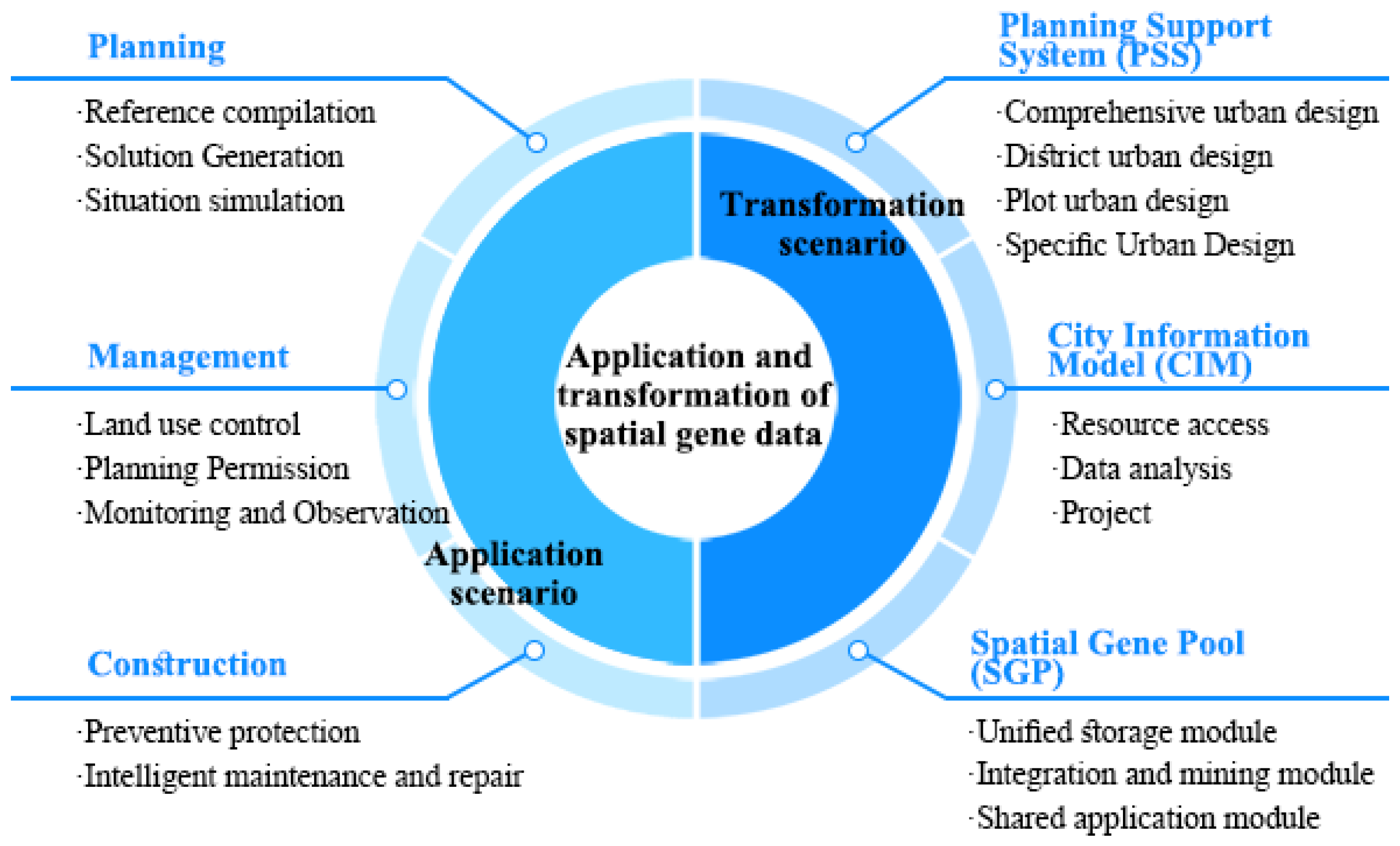
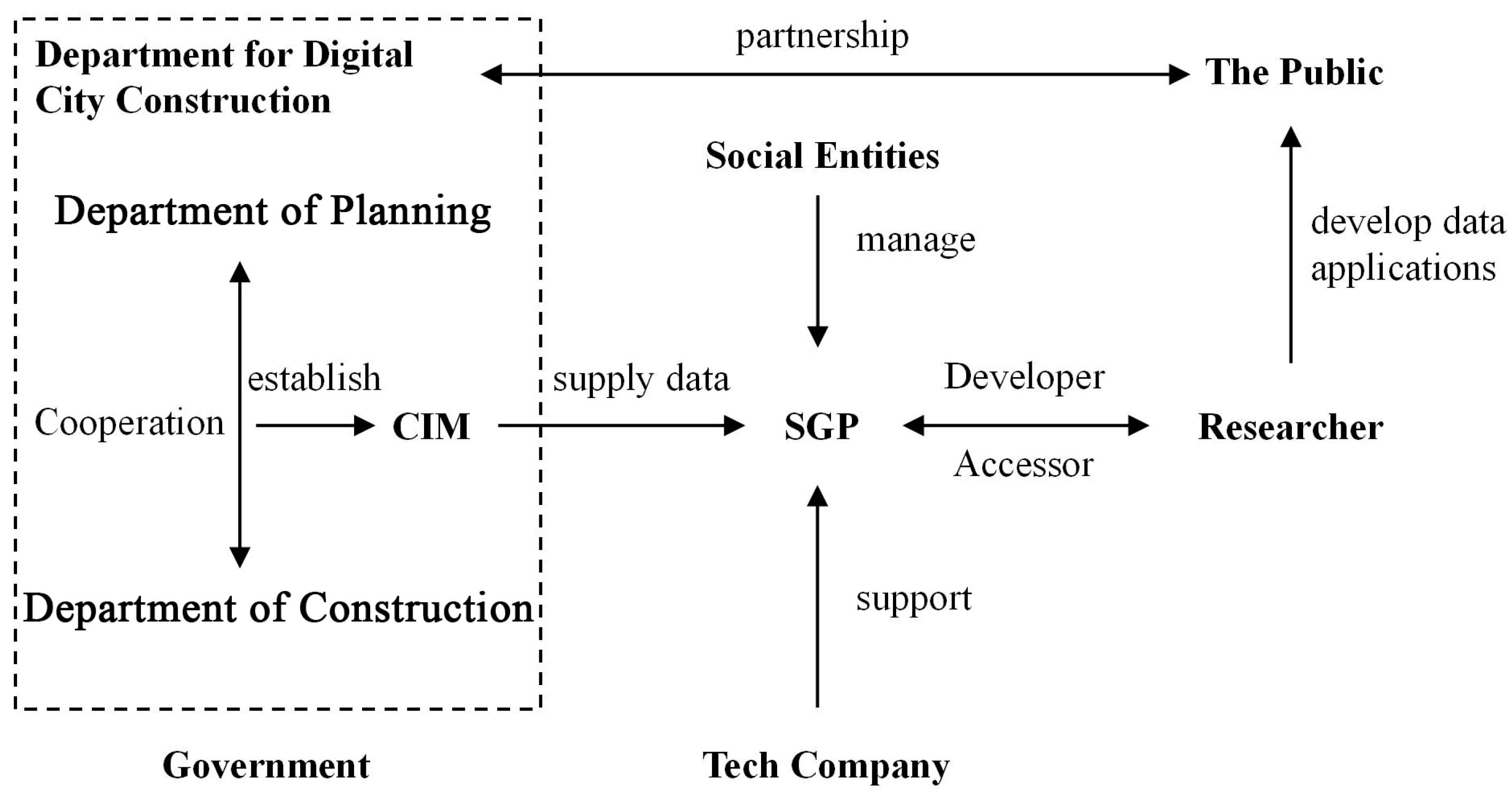
6.3. Spatial Gene Pool
- (1)
- The unified storage module includes regional and urban sample libraries alongside multi-source data archives;
- (2)
- The integration and extraction module features various spatial-gene analysis tools software along with online analytical platforms;
- (3)
- The shared application module comprises spatial-gene banks, research project repositories, engineering project databases, scientific literature collections, etc. (Figure 7).
7. Conclusions
Author Contributions
Funding
Data Availability Statement
Acknowledgments
Conflicts of Interest
References
- Sassen, S. Agglomeration in Digital Era. In Cities in a World Economy; Pine Forge Press: London, UK, 2000. [Google Scholar]
- Kamrowska-Zaluska, D.; Obracht-Prondzyńska, H. The Use of Big Data in Regenerative Planning. Sustainability 2018, 10, 3668. [Google Scholar] [CrossRef]
- Sanchez, T.W.; Shumway, H.; Gordner, T.; Lim, T. The prospects of artificial intelligence in urban planning. Int. J. Urban Sci. 2022, 27, 179–194. [Google Scholar] [CrossRef]
- Rabari, C.; Storper, M. The digital skin of cities: Urban theory and research in the age of the sensored and metered city, ubiquitous computing and big data. Camb. J. Reg. Econ. Soc. 2015, 8, 27–42. [Google Scholar] [CrossRef]
- Meza, J.; Vaca-Cárdenas, L.; Vaca-Cárdenas, M.E.; Terán, L.; Portmann, E. A Human-Machine Collaboration Model for Urban Planning in Smart Cities. Computer 2021, 54, 24–35. [Google Scholar] [CrossRef]
- Mayer-Schönberger, V.; Cukier, K. Big Data: A Revolution That Will Transform How We Live, Work, and Think; Houghton Mifflin Harcourt: Boston, MA, USA, 2013. [Google Scholar]
- Li, W.; Li, L.; Goodchild, M.F.; Anselin, L. A Geospatial Cyberinfrastructure for Urban Economic Analysis and Spatial Decision-Making. ISPRS Int. J. Geo-Inf. 2013, 2, 413–431. [Google Scholar] [CrossRef]
- Burnaz, A.M. Methodology and Database Requirements for Urban Regeneration Action Planning: The Case of Zeytinburnu, İstanbul. Master’s Thesis, Middle East Technical University, Ankara, Turkey, 2004. [Google Scholar]
- Lanter, D.P. Design of a Lineage-Based Meta-Data Base for GIS. Cartogr. Geogr. Inf. Syst. 1991, 18, 255–261. [Google Scholar] [CrossRef]
- Yang, C.; Raskin, R.; Goodchild, M.; Gahegan, M. Geospatial Cyberinfrastructure: Past, present and future. Comput. Environ. Urban Syst. 2010, 34, 264–277. [Google Scholar] [CrossRef]
- Foth, M.; Brynskov, M.; Ojala, T. Citizen’s Right to the Digital City; Springer: Berlin/Heidelberg, Germany, 2015. [Google Scholar]
- Lăzăroiu, G.; Ionescu, L.; Andronie, M.; Dijmărescu, I. Sustainability Management and Performance in the Urban Corporate Economy: A Systematic Literature Review. Sustainability 2020, 12, 7705. [Google Scholar] [CrossRef]
- Benghi, C. Automated verification for collaborative workflows in a Digital Plan of Work. Autom. Constr. 2019, 107, 102926. [Google Scholar] [CrossRef]
- Duan, J.; Shao, R.; Lan, W.; Liu, J.; Jiang, Y. Space Gene. City Plan. Rev. 2019, 43, 14–21. [Google Scholar]
- Jiang, Y.; Li, N.; Wang, Z. Parametric Reconstruction of Traditional Village Morphology Based on the Space Gene Perspective—The Case Study of Xiaoxi Village in Western Hunan, China. Sustainability 2023, 15, 2088. [Google Scholar] [CrossRef]
- Xiang, H.; Qin, Y.; Xie, M.; Zhou, B. Study on the “Space Gene” Diversity of Traditional Dong Villages in the Southwest Hunan Province of China. Sustainability 2022, 14, 14306. [Google Scholar] [CrossRef]
- Nie, Z.; Li, N.; Pan, W.; Yang, Y.; Chen, W.; Hong, C. Quantitative Research on the Form of Traditional Villages Based on the Space Gene—A Case Study of Shibadong Village in Western Hunan, China. Sustainability 2022, 14, 8965. [Google Scholar] [CrossRef]
- Vasícek, J.; Balázi, A.; Bauer, M.; Svoradová, A.; Tirpáková, M.; Tomka, M.; Chrenek, P. Molecular Profiling and Gene Banking of Rabbit EPCs Derived from Two Biological Sources. Genes 2021, 12, 366. [Google Scholar] [CrossRef] [PubMed]
- Christodoulou, J.A. Integrated Computational Materials Engineering and Materials Genome Initiative: Accelerating Materials Innovation. Adv. Mater. Process. 2013, 171, 28–31. [Google Scholar] [CrossRef]
- Duan, J.; Jiang, Y.; Li, Y.; Lan, W. Space Gene: Connotation and Functional Mechanism. City Plan. Rev. 2022, 46, 7–14. [Google Scholar]
- Porter, M.E. Competitive Advantage: Creating and Sustaining Superior Performance; The Free Press: London, ON, Canada, 1985. [Google Scholar]
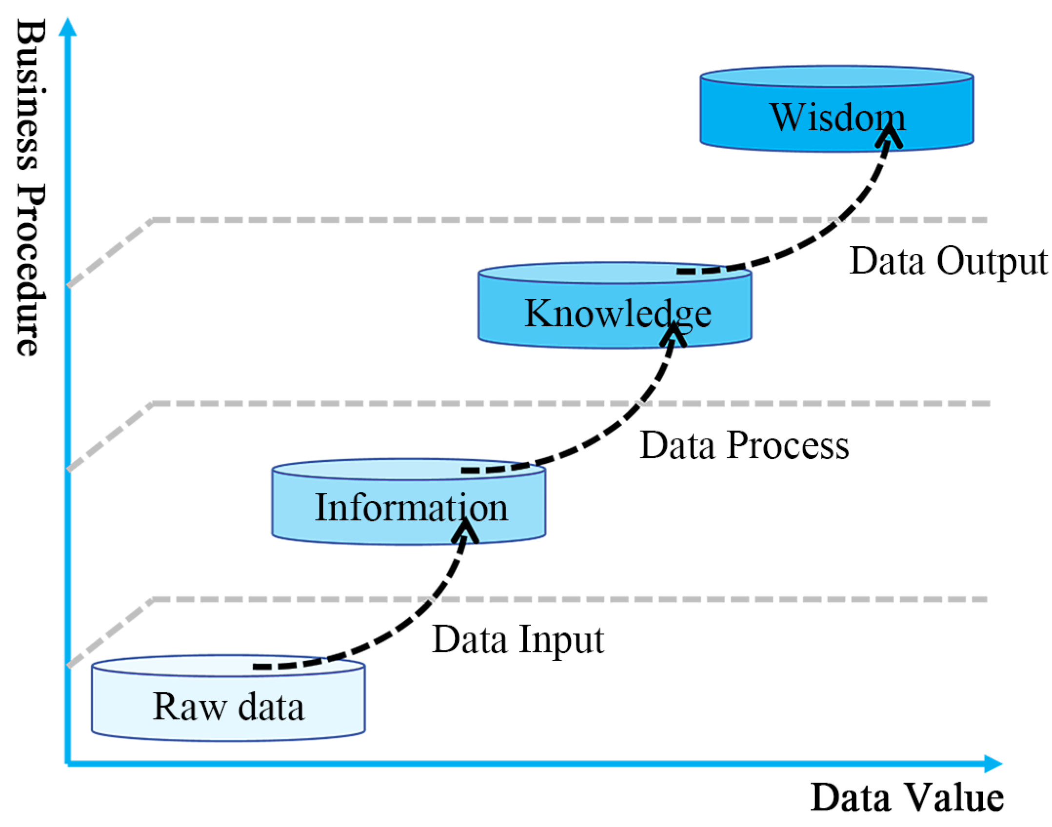
- Miller, H.G.; Mork, P. From data to decisions: A value chain for big data. IT Prof. 2013, 15, 57–59. [Google Scholar] [CrossRef]
- Susha, I.; Pardo, T.A.; Janssen, M.; Adler, N.; Verhulst, S.G.; Harbour, T. A Research Roadmap to Advance Data Collaboratives Practice as a Novel Research Direction. Int. J. Electron. Gov. Res. 2018, 14, 1–11. [Google Scholar] [CrossRef]
- Antoniou, G.; van Harmelen, F. A Semantic Web Primer; MIT Press: Cambridge, MA, USA, 2004. [Google Scholar]
- Shen, W.; Hao, Q.; Mak, H.; Neelamkavil, J.; Xie, H.; Dickinson, J.; Thomas, R.; Pardasani, A.; Xue, H. Systems integration and collaboration in architecture, engineering, construction, and facilities management: A review. Adv. Eng. Inform. 2010, 24, 196–207. [Google Scholar] [CrossRef]
- Karimi, Y.; Kashani, M.H.; Akbari, M.; Mahdipour, E. Leveraging big data in smart cities: A systematic review. Concurr. Comput. Pract. Exp. 2021, 33, e6379. [Google Scholar] [CrossRef]
- Zou, X.; Yan, Y.; Hao, X.; Hu, Y.; Wen, H.; Liu, E.; Zhang, J.; Li, Y.; Li, T.; Zheng, Y.; et al. Deep learning for cross-domain data fusion in urban computing: Taxonomy, advances, and outlook. Inf. Fusion 2025, 113, 102606. [Google Scholar] [CrossRef]
- Wright, D.J.; Wang, S. The emergence of spatial cyberinfrastructure. Proc. Natl. Acad. Sci. USA 2011, 108, 5488–5491. [Google Scholar] [CrossRef] [PubMed]
- Jing, C.F.; Zhu, Y.L.; Fu, J.Y.; Dong, M. A Lightweight Collaborative GIS Data Editing Approach to Support Urban Planning. Sustainability 2019, 11, 4437. [Google Scholar] [CrossRef]
- Hancke, G.P.; Silva, B.D.C.e.; Hancke, G.P., Jr. The Role of Advanced Sensing in Smart Cities. Sensors 2013, 13, 393–425. [Google Scholar] [CrossRef]
- Thomson, G.; Newman, P. Urban fabrics and urban metabolism–from sustainable to regenerative cities. Resour. Conserv. Recycl. 2018, 132, 218–229. [Google Scholar] [CrossRef]
- Zheng, Y.; Lin, Y.; Zhao, L.; Wu, T.; Jin, D.; Li, Y. Spatial planning of urban communities via deep reinforcement learning. Nat. Comput. Sci. 2023, 3, 748–762. [Google Scholar] [CrossRef]
- Mohammadi, N.; Taylor, J.E. Thinking fast and slow in disaster decision-making with Smart City Digital Twins. Nat. Comput. Sci. 2021, 1, 771–773. [Google Scholar] [CrossRef]
- Mnih, V.; Kavukcuoglu, K.; Silver, D.; Rusu, A.A.; Veness, J.; Bellemare, M.G.; Graves, A.; Riedmiller, M.; Fidjeland, A.K.; Ostrovski, G.; et al. Human-level control through deep reinforcement learning. Nature 2015, 518, 529–533. [Google Scholar] [CrossRef]
- Batty, M. Big data, smart cities and city planning. Dialogues Hum. Geogr. 2013, 3, 274–279. [Google Scholar] [CrossRef]
- Kingston, J.D. Shifting adaptive landscapes: Progress and challenges in reconstructing early hominid environments. Am. J. Phys. Anthropol. 2007, 134, 20–58. [Google Scholar] [CrossRef]
- Langton, C.G. Studying artificial life with cellular automata. Phys. D Nonlinear Phenom. 1986, 22, 120–149. [Google Scholar] [CrossRef]
- McRae, B. Integrating Landscape Ecology and Population Genetics: Conventional Tools and a New Model. Ph.D. Thesis, Northern Arizona University, Flagstaff, AZ, USA, 2004. [Google Scholar]
- Batty, M.; Longley, P. Fractal Cities: A Geometry of Form and Function; Academic Press: London, UK, 1994. [Google Scholar]
- Silva, E.A. The DNA of our regions: Artificial intelligence in regional planning. Futures 2004, 36, 1077–1094. [Google Scholar] [CrossRef]
- Wilson, A. Urban and Regional Dynamics-3: “DNA” and “Genes” as a Basis for Constructing a Typology of Areas; CASA Working Paper 130; Centre for Advanced Spatial Analysis (UCL): London, UK, 2008. [Google Scholar]
- Wu, N.; Silva, E.A. Urban DNA: Exploring the Biological Metaphor of Urban Evolution With DG-ABC Model. In Proceedings of the 14th AGILE International Conference on Geographic Information Science, Salt Lake City, UT, USA, 7–13 August 2011. [Google Scholar]
- Conzen, M.R.G. Alnwick, Northumberland: A Study in Town-Plan Analysis; Institute of British Geographers: London, UK, 1969. [Google Scholar]
- Alexander, C.; Ishikawa, S.; Silverstein, M.; Jacobson, M.; Fiksdahl-King, I.; Angel, S. A Pattern Language: Towns, Buildings, Construction; Oxford University Press: New York, NY, USA, 1977. [Google Scholar]
- Caniggia, G.; Maffei, G.L. Architectural Composition and Building Typology; Alinea Editrice: Firenze, Italy, 2001. [Google Scholar]
- Marshall, S. Urbanism in Evolution: New Urbanism and Beyond; Congress for the New Urbanism: Austin, TX, USA, 2007; Available online: https://www.cnu.org/sites/default/files/smarshall_cnu16.pdf (accessed on 20 December 2018).
- D’Acci, L. Urban DNA for cities evolutions. Cities as physical expression of dynamic equilibriums between competitive and cooperative forces. arXiv 2014, arXiv:1408.2874. [Google Scholar]
- Votsis, A.; Haavisto, R. Urban DNA and Sustainable Cities: A Multi-City Comparison. Front. Environ. Sci. 2019, 7, 4. [Google Scholar] [CrossRef]
- Mitz, E.; Kremer, P.; Larondelle, N.; Stewart, J.D. Structure of Urban Landscape and Surface Temperature: A Case Study in Philadelphia, PA. Front. Environ. Sci. 2021, 9, 592716. [Google Scholar] [CrossRef]
- TD/T 1065-2021; Urban Design Guidelines for Territorial Planning. Geological Publishing House: Beijing, China, 2021.
- Duan, J. Trickle of Water Accumulates into River: The Exploration and Prospect of Spatial Gene Research in Characteristic Villages and Towns. Dev. Small Cities Towns 2023, 41, 1. [Google Scholar]
- Kasim, H.; Hung, T.; Li, X. Data value chain as a service framework: For enabling data handling, data security and data analysis in the cloud. In Proceedings of the 2012 IEEE 18th International Conference on Parallel and Distributed Systems, Singapore, 17–19 December 2012; pp. 804–809. [Google Scholar]
- Bizer, C.; Boncz, P.; Brodie, M.L.; Erling, O. The meaningful use of big data: Four perspectives—Four challenges. ACM Sigmod Rec. 2012, 40, 56–60. [Google Scholar] [CrossRef]
- Köppen, V.; Brüggemann, B.; Berendt, B. Designing data integration: The ETL pattern approach. UPGRADE Eur. J. Inform. Prof. 2011, 3, 49–55. [Google Scholar]
- R Core Team. R: A Language and Environment for Statistical Computing. Available online: https://www.r-project.org/ (accessed on 20 October 2024).
- Singh, P.J. Breaking up Big Tech: Separation of Its Data, Cloud and Intelligence Layers. Data Governance Network Working Paper 09. 1 June 2020. Available online: https://ssrn.com/abstract=3873151 (accessed on 20 October 2024).
- Semlali, B.-E.B.; El Amrani, C.; Ortiz, G. SAT-ETL-Integrator: An extract-transform-load software for satellite big data ingestion. Appl. Remote Sens. 2020, 14, 018501. [Google Scholar] [CrossRef]
- Jeong, D.; Lee, C.; Choi, Y.; Jeong, T. Building Digital Twin Data Model Based on Public Data. Buildings 2024, 14, 2911. [Google Scholar] [CrossRef]
- Saalfeld, A. Conflation Automated map compilation. Int. J. Geogr. Inf. Syst. 1988, 2, 217–228. [Google Scholar] [CrossRef]
- Van Nes, A. Phenotypes and Genotypes of Traditional Norwegian wooden Farms: Space Syntax Analyses of Norway’s Smallest Settlement Units. Urban Des. 2022, 6, 6–21. [Google Scholar] [CrossRef]
- Wang, Y.; Kung, L.; Byrd, T. Big data analytics: Understanding its capabilities and potential benefits for healthcare organizations. Technol. Forecast. Soc. Chang. 2018, 126, 3–13. [Google Scholar] [CrossRef]
- Bloomberg, J. Digitization, digitalization, and digital transformation: Confuse them at your peril. Forbes 2018, 28, 1–6. [Google Scholar]
- Gong, C.; Ribiere, V. Developing a unified definition of digital transformation. Technovation 2021, 102, 102217. [Google Scholar] [CrossRef]
- LaValle, S.; Lesser, E.; Shockley, R.; Hopkins, M.S.; Kruschwitz, N. Big data, analytics and the path from insights to value. MIT Sloan Manag. Rev. 2011, 52, 21–31. [Google Scholar]
- Thagard, P. Emotional cognition in urban planning and design. In Complexity Cognition Urban Planning and Design; Springer: Berlin/Heidelberg, Germany, 2016; pp. 197–213. [Google Scholar]


| Analysis Methods | Commentary |
|---|---|
| Element Analysis | Investigate the elemental composition within a specific spatial system. |
| Structural Analysis | Calculate the proportion of each component in a particular spatial system. |
| Network Analysis | Abstract the relationships between spatial elements into networks and employ computational methods and indicators to describe the network structures. |
| Clustering Algorithm | Acquire the cross-relationships among different spatial elements and characteristic factors in a quantitative manner. |
| “Space-Nature-Culture” Interactive Analysis | Disclose the mechanism of the interactive influence of various urban systems behind spatial genes. |
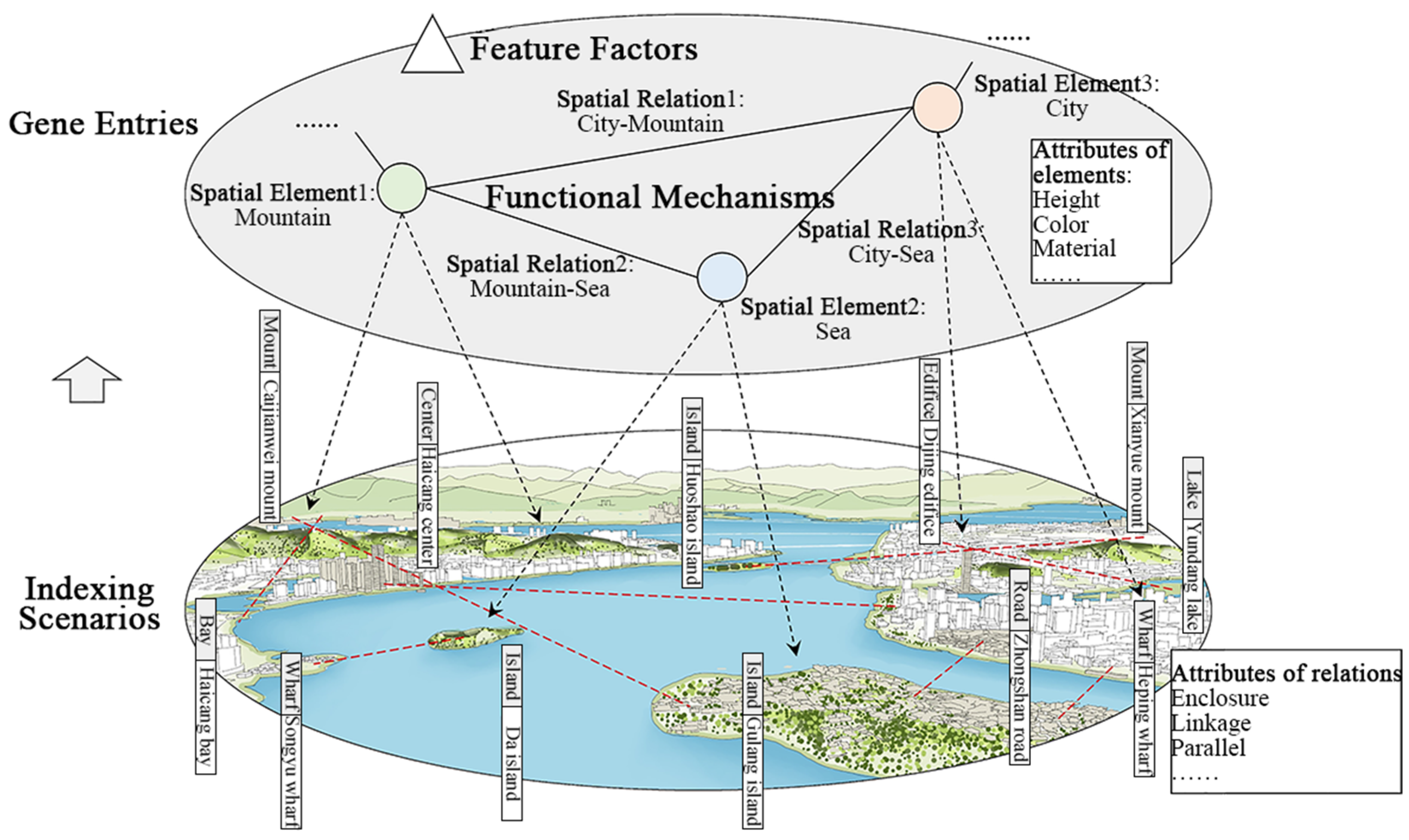
| Ontology Elements | Commentary | Data Type |
|---|---|---|
| Gene entries | As the category criterion for the attribute characteristics of space genes, it is indicated in textual form and is the basic element composition or spatial organizational object of spatial genes. | Text |
| Indexing scenarios | It is employed to depict the spatio-temporal coordinates of typical and representative urban scenes controlled by spatial genes, which is of vital significance for comprehending the degree to which spatial genes exert their effects and the conditions they demand. | Vector, Image |
| Feature factors | It is composed of the configuration rules of several elements refined by spatial genes and their index values. | Text, value |
| Functional Mechanisms | It is necessary to employ the “space-nature-culture” system to disclose the mechanism of the interactive influence of various urban systems behind spatial genes. | Text |
Disclaimer/Publisher’s Note: The statements, opinions and data contained in all publications are solely those of the individual author(s) and contributor(s) and not of MDPI and/or the editor(s). MDPI and/or the editor(s) disclaim responsibility for any injury to people or property resulting from any ideas, methods, instructions or products referred to in the content. |
© 2024 by the authors. Licensee MDPI, Basel, Switzerland. This article is an open access article distributed under the terms and conditions of the Creative Commons Attribution (CC BY) license (https://creativecommons.org/licenses/by/4.0/).
Share and Cite
Lan, W.; Chen, J.; Duan, J.; Li, J. Convergence, Mining, and Application: A Data Collaboration Framework for Spatial-Gene Research and Practice. Buildings 2024, 14, 3824. https://doi.org/10.3390/buildings14123824
Lan W, Chen J, Duan J, Li J. Convergence, Mining, and Application: A Data Collaboration Framework for Spatial-Gene Research and Practice. Buildings. 2024; 14(12):3824. https://doi.org/10.3390/buildings14123824
Chicago/Turabian StyleLan, Wenlong, Jingheng Chen, Jin Duan, and Junyi Li. 2024. "Convergence, Mining, and Application: A Data Collaboration Framework for Spatial-Gene Research and Practice" Buildings 14, no. 12: 3824. https://doi.org/10.3390/buildings14123824
APA StyleLan, W., Chen, J., Duan, J., & Li, J. (2024). Convergence, Mining, and Application: A Data Collaboration Framework for Spatial-Gene Research and Practice. Buildings, 14(12), 3824. https://doi.org/10.3390/buildings14123824