Article

Analysis of the Spatiotemporal Distribution Characteristics and Influencing Factors of High-Grade Cultural Heritage in the Region Surrounding Mount Song

School of Architecture, Zhengzhou University, Zhengzhou 450001, China
*
Author to whom correspondence should be addressed.
Buildings 2024, 14(10), 3259; https://doi.org/10.3390/buildings14103259
Submission received: 14 September 2024 / Revised: 10 October 2024 / Accepted: 12 October 2024 / Published: 15 October 2024
(This article belongs to the Section Architectural Design, Urban Science, and Real Estate)

Abstract

Situated in central China, the region surrounding Mount Song is a pivotal area within the Central Plains, renowned for its extensive and high-grade cultural heritage. This study aims to analyze the spatiotemporal distribution of this heritage using advanced spatial pattern analysis methods, including the Average Nearest Neighbor Ratio and Kernel Density Estimation within ArcGIS. Our findings reveal a distinct continuity in temporal distribution and a pronounced clustering in spatial terms. By investigating the underlying factors such as the geographical setting, historical political capitals, cultural and religious influences, water transportation systems, and traditional Fengshan ceremonies, this research elucidates the dynamics shaping this distribution. This study’s outcomes provide essential insights for policymakers and stakeholders involved in the protection and revitalization of cultural heritage, ensuring informed decision making for sustainable cultural conservation.

1. Introduction

Cultural heritage conservation has emerged as a pivotal global concern, reflecting a growing recognition of the intrinsic value and vulnerability of cultural assets worldwide. Initiated in the early 20th century, efforts to protect cultural heritage began primarily with tangible elements such as monuments and artworks [1]. The devastation witnessed during World War II galvanized international cooperation, leading to the establishment of UNESCO and the adoption of several pivotal conventions, including the 1954 Hague Convention and the 1972 World Cultural and Natural Heritage Protection Convention [2,3]. The scope of heritage conservation has since expanded to include intangible aspects, culminating in the 2003 UNESCO Convention for the Safeguarding of the Intangible Cultural Heritage, marking a significant evolution in heritage protection paradigms [4].
In China, the approach to cultural heritage conservation has mirrored global trends while being deeply influenced by the country’s rich history and cultural significance [5]. China categorizes its immovable cultural relics into four levels: national, provincial, municipal/county, and general immovable cultural relics [6,7]. National and provincial levels, recognized for their significant conservation and research value, are the focus of this study and are collectively referred to as high-grade cultural heritage. Since the 1980s, China has developed a robust framework for heritage protection, which has been continually refined in response to rapid socio-economic transformations and the challenges they pose to heritage sites [8]. This includes the integration of traditional Chinese philosophies with modern conservation techniques, highlighting a unique blend of respect for antiquity and progressive management strategies [9]. Major projects such as the restoration of the Great Wall and the conservation of the Terracotta Army have underscored China’s commitment to preserving its cultural legacy.
Studies across the globe have shown that many significant cultural heritage sites are often located near rivers or in areas with specific geographical features, reflecting the profound link between cultural heritage and natural resources as well as human activities [10,11,12]. This pattern not only reveals the deep connections between cultural heritage and geographical environments but also indicates the critical role these environments play in the formation and conservation of heritage [13]. Against this backdrop, this research aims to explore the spatiotemporal distribution of high-grade cultural heritage in the region surrounding Mount Song, particularly investigating whether the distribution of these cultural assets is related to rivers, political–economic centers, historical religious activities, and other factors, thereby providing a comprehensive understanding of the mechanisms influencing cultural heritage conservation and sustainable management strategies.

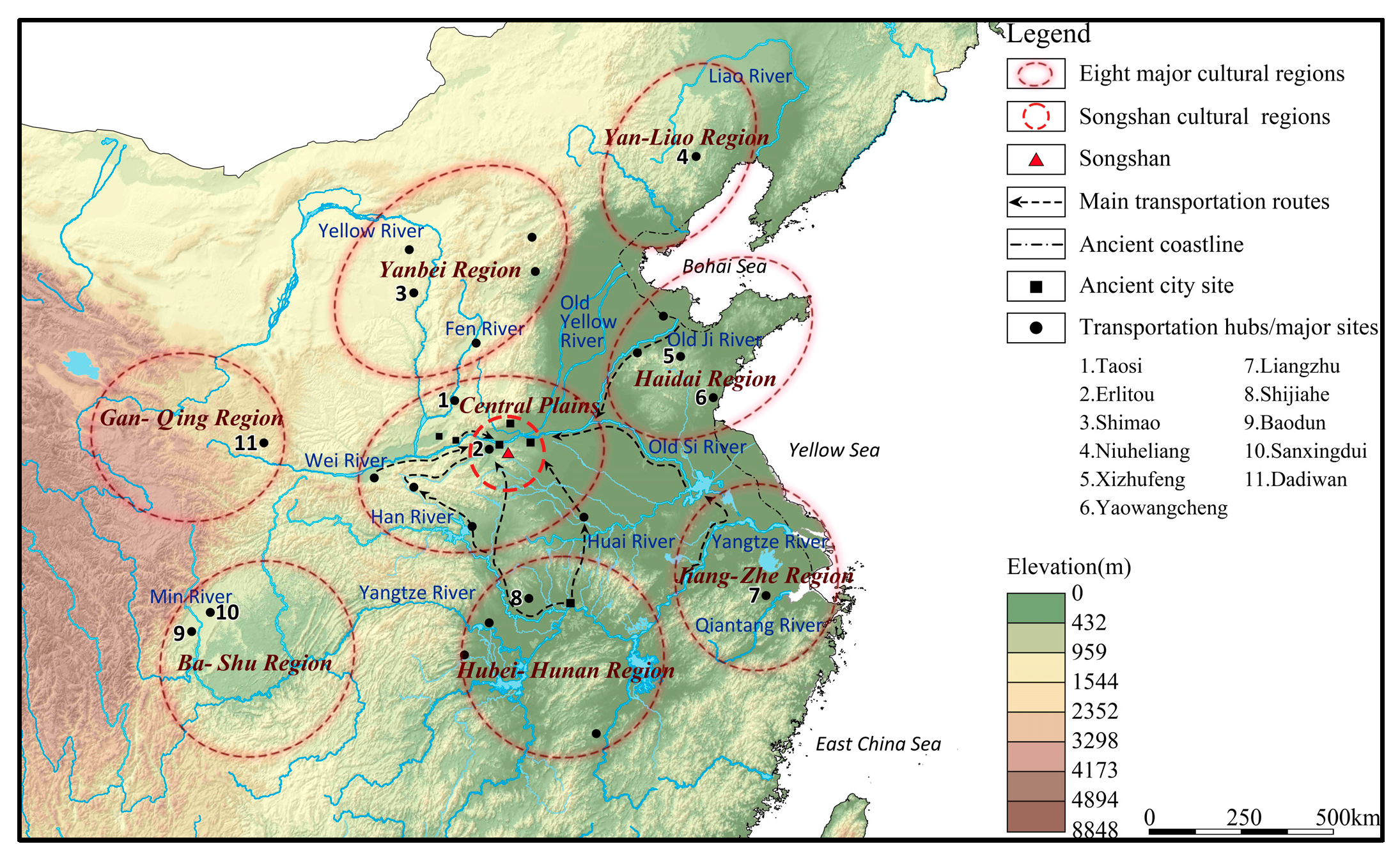
2. The Origin of Research on the Songshan Region

After the 1970s, archaeological research in China primarily centered on the “Three Central Issues” (the Chinese nation, the Chinese state, and Chinese culture) [14]. The “reconstruction of ancient history” aimed at these issues has been an important goal and measure of the development of archaeological research [15]. Consequently, the emergence of “super settlements” associated with early states, such as Wangchenggang in Dengfeng and Erlitou in Yanshi, has positioned the area surrounding the Songshan Mountains as a focal point for two major initiatives: the “Dating Project of the Xia, Shang, and Zhou Dynasties” (1996–2001) and the “Chinese Civilization Origin Project” (2002–2022) [16].
In 2002, Zhou Kunshu, an environmental archaeologist, first introduced the concept of the “Songshan Cultural Circle” [17] at the Third International Conference on Environmental Archaeology. His presentation highlighted the critical role of natural environmental factors in shaping regional cultures, offering a fresh perspective and methodology for exploring the prehistoric environment of the Songshan area. Following this, in 2004, a collaborative effort supported by the National Natural Science Foundation enabled further exploration. Researchers from five key institutions—the Institute of Geology and Geophysics at the Chinese Academy of Sciences, the Zhengzhou Institute of Cultural Relics and Archaeology, and the Institute of Geography at the Henan Academy of Sciences—conducted detailed studies. Their work focused on the prehistoric human living environment in the Shuangqiao River basin, located in the southeastern region of the Songshan area. During their research, they systematically defined the connotation and explored the formation mechanisms of the “Songshan Cultural Circle.” They proposed that Songshan acted as an engine and incubator in the formation of ancient cultures in the Central Plains, and that the Songshan Cultural Circle resulted from the continuous exchange of cultures between the Songshan area and surrounding regions, becoming the core of ancient culture at that time [18].
Since 2011, supported by the National Natural Science Foundation, a series of achievements have been made in the research on the spatial distribution [19,20], type classification [21], and site selection of settlements [22] during the prehistoric period in the region surrounding Mount Song. These findings demonstrate the complexity of the interactions between the environment and culture, revealing how the evolution of the natural environment in the region surrounding Mount Song has influenced and interacted with the lifestyles and cultural forms of prehistoric settlements. Since 2018, with the support of techniques such as clustering algorithms [23], archaeobotany [24,25], and scientific archaeology [26], the understanding of the period from the Longshan culture (3000 BC to 1900 BC) to the Erlitou culture (1900 BC to 1500 BC) in the region surrounding Mount Song has become more enriched and comprehensive. Currently, research on the region surrounding Mount Song primarily focuses on prehistoric periods and archaeological excavations of settlement sites, as well as the findings from these studies. There is a lack of systematic organization and research into the relatively significant cultural heritage found in the area from the prehistoric era to the advent of civilized society. There is a need for more comprehensive research to fully reveal the rich cultural heritage of the Mount Song area and the underlying geographical, environmental, and political–cultural drivers behind it.

3. Research Area and Methods
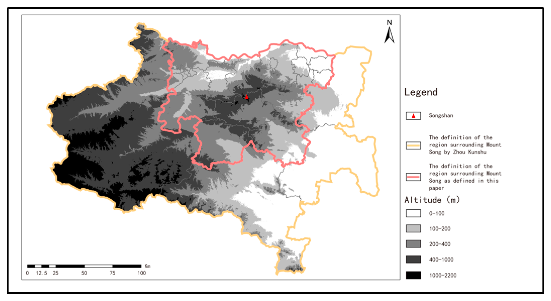
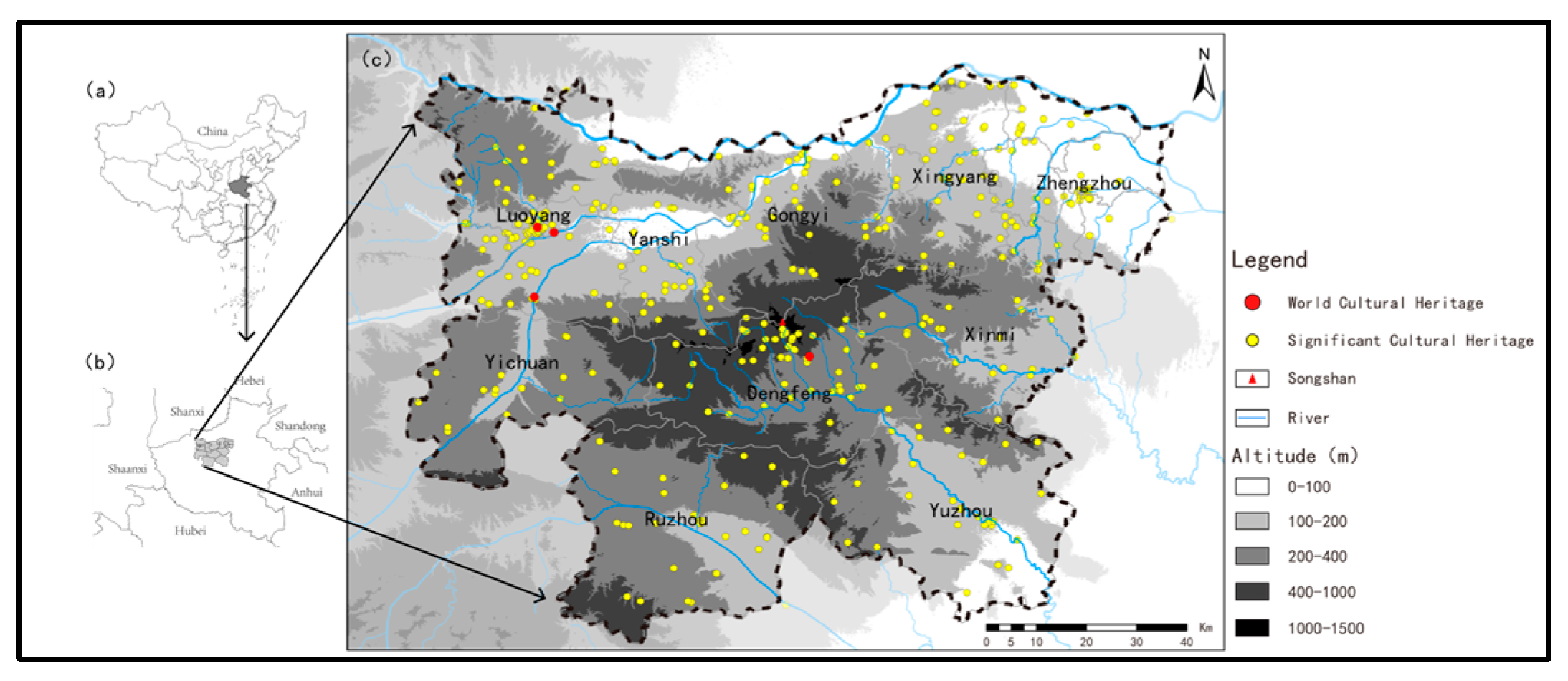
3.1. Research Area

The research area for this study, initially outlined by Zhou Kunshu and Lu Peng during their investigations into prehistoric settlements, focuses on the region surrounding Mount Song. It includes the cities of Zhengzhou, Luoyang, Xuchang, and Pingdingshan, along with their surrounding areas such as Yichuan, Dengfeng, Yanshi, Gongyi, Xingyang, Xinmi, Xinzheng, Yuzhou, and Ruzhou, spanning approximately 35,600 square kilometers [19,27]. These areas are enclosed within the administrative boundaries of four prefecture-level cities and their subordinate counties and cities.
Despite their inclusion, some of these areas hold limited direct relevance to the Songshan Cultural Circle. Consequently, this study narrows the focus to areas with intrinsic connections to the Songshan Cultural Circle, specifically targeting districts within Luoyang, Pingdingshan, Xuchang, and Zhengzhou that are most representative of the Songshan cultural influences. The selected districts include Luoyang’s Jianxi, Xigong, Old City, Chanhe, and Luolong Districts; Yanshi and Mengjin Districts; Yichuan County; Ruzhou City in Pingdingshan; Yuzhou City in Xuchang; and the Zhongyuan, Erqi, Guancheng, Jinshui, Shangjie, and Huiji Districts in Zhengzhou, along with Dengfeng City, Gongyi City, Xingyang City, and Xinmi City (Figure 1).
This refined research area covers 11,800 square kilometers or approximately 7% of Henan Province’s total area, supporting a population of 15.78 million, which accounts for about 16% of the provincial total (Figure 2c).
The character “嵩” (Song) first appeared in the “Song Gao” chapter of the Book of Songs: Major Odes, with the line “Song, the lofty mountain, rises majestically to the heavens”. According to the “Shi Ming-Shi Shan” (Interpretations of Names: Mountains), “Song means standing tall”, so Mount Song became the object of imperial sacrifice and consecration for the prosperity and celestial connection of the state throughout the dynasties. The inscription on the “Heavenly King Gui” vessel from the early Western Zhou period records that after King Wu of Zhou overthrew the Shang dynasty, he “offered sacrifices at Tai Shi (the main peak), “initiating the precedent for the most grand and highest-level consecration rites in China”. According to Sima Qian’s Records of the Grand Historian: Book of Consecrations, “In ancient times, the capitals of the three dynasties were all located between the Yellow River and the Luo River, so Mount Song was considered the central mountain”. From then on, Mount Song was known as Zhongyue, becoming the premier among the Five Great Mountains. After the Qin and Han dynasties, imperial sacrifices to Mount Song continued without interruption. From Emperor Wu of Han to Empress Wu Zetian of the Tang dynasty, up until the end of the Qing dynasty, there are historical records of 68 emperors who conducted tours, sacrifices, and consecrations at Mount Song [28].
The region surrounding Mount Song is located in the core area of China’s Central Plains. It is both the geographical center and historically a center of politics, economy, and culture. The climate of the region falls between subtropical and warm temperate zones, fostering abundant biodiversity and giving rise to some of the earliest forms of grain agriculture. This area falls within the watersheds of the Yellow River and the Huai River, characterized by numerous rivers and an extensive network of waterways. The regional topography is varied, primarily consisting of high and low hills. The unique environmental and ecological characteristics of the Mount Song area have historically fostered advanced economic development and a flourishing civilization. This region, termed “the birthplace of nations”, signifies its pivotal role in the early formation of Chinese civilization. The phrase encapsulates the emergence of complex societal structures and state entities, as evidenced by significant archaeological findings and historical records. Such developments illustrate how the natural setting of Mount Song contributed to cultural and political advancements that were foundational to the establishment of ancient Chinese states [29] (Figure 3). Therefore, Mount Song is the incubator of the Central Plains culture, and the region surrounding Mount Song is the core area of the “Central Plains Cultural Zone” [30]. “From the Neolithic age through the Xia, Shang, and Zhou dynasties, and up until the end of the Northern Song Dynasty, a period spanning over 3000 years, the region surrounding Mount Song consistently served as the political, economic, and cultural center of China. It ultimately crystallized into the cultural core of “the center of heaven and earth”, forming the foundation of Chinese cultural identity.

3.2. Research Subject

The focus of this thesis is the high-grade cultural heritage within the Mount Song region, encompassing prehistoric remains and significant relics designated as national- and provincial-level protection units. These cultural assets date back to the earliest stages of civilized society in the area.
As of the end of 2023, the Mount Song area contains 393 recognized high-grade cultural heritage sites. These include 4 World Cultural Heritage Sites, 134 key national cultural relic protection units (from the first to the eighth batches), and 255 provincial-level units in Henan. Data for these designations were sourced from the official listings published by the State Council of the PRC [31] and the Henan Provincial Cultural Heritage Bureau [32].
Utilizing Google Earth Pro, version 7.3 software, the study gathered 12.5 m resolution elevation data for the Mount Song region. These data were instrumental in establishing a spatial attribute database using ArcGIS 10.8 software. The resulting database supports the analysis of high-grade cultural heritage sites, as depicted on the map created for this study (Figure 2).

3.3. Research Methods

3.3.1. Average Nearest Neighbor Ratio

The Average Nearest Neighbor Ratio is an indicator used to measure the spatial distribution pattern of points. It is utilized to determine whether the distribution of high-grade cultural heritage in the region surrounding Mount Song is clustered, random, or uniform. The formula for calculating it is as follows:
A N N = D 0 ¯ D E ¯ , D 0 ¯ = i = 0 n d i / n , D E ¯ = 0.5 n / A
In the formula, ANN represents the Average Nearest Neighbor Ratio and is the average distance between each feature and its nearest neighboring feature, and D E ¯ is the expected random distribution distance for the same number of features in the study area. ANN is the projected area of the region surrounding Mount Song. Ann is the total number of features. If ANN < 1, it indicates that the points tend to be clustered; if ANN = 1, it indicates a random distribution; and if ANN > 1, it indicates a uniform distribution.

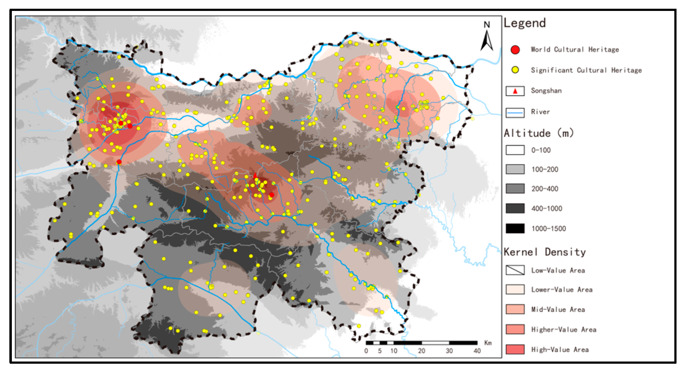
3.3.2. Kernel Density Estimation

Kernel Density Estimation (KDE) is a non-parametric method used to estimate the probability density function of a random variable. Through kernel density analysis, a continuous density surface can be generated to reflect the spatial distribution density of cultural heritage. The calculation formula is as follows:
D K = 1 r 2 i = 1 n 3 π 1 d i r 2 2
In the formula, D K represents kernel density, r is the radius of the statistical range, and d i denotes the distance from each feature within the statistical range to the grid cell.

3.3.3. Buffer Analysis

Buffer analysis involves creating areas at specified distances around a particular object and is commonly used to analyze and understand spatial relationships between geographic features. By taking major rivers and ancient roads as the subjects of analysis, multi-ring buffers are established at certain distances. The number of heritages within the buffers for each period is then counted to assess the relationship between high-grade cultural heritage and rivers or ancient roads. The formula for this analysis is as follows:
B = x | d x , o R
In the formula, which represents the points of high-grade cultural heritage, o is the given spatial target, d is the distance between x and o , and R is the buffer distance. The analysis involves evaluating whether d is less than or equal to R , indicating that the heritage point x falls within the buffer zone around the target o .

3.3.4. Bivariate Correlation Analysis

Bivariate correlation analysis measures and assesses the strength and direction of the linear relationship between two variables. Using IBM SPSS Statistics 27 software, an analysis of the relationship between the quantity of high-grade cultural heritage in the region surrounding Mount Song and different elevation levels is conducted. The Pearson correlation coefficient, derived from this analysis, reflects the degree of correlation between the two variables. The formula is as follows:
r = x i x ¯ y i y ¯ x i x ¯ 2 y i y ¯ 2
where r is the Pearson correlation coefficient, and y i is the individual sample points indexed with i, and y ¯ is the means of the X and Y variables. This coefficient r ranges from −1 to +1, where −1 indicates a perfect negative linear relationship, +1 indicates a perfect positive linear relationship, and 0 indicates no linear relationship. This analysis helps to understand how closely the distribution of cultural relics at higher elevations correlates with the elevation factor in a specific geographic area.

3.3.5. Standard Deviational Ellipse

The Standard Deviational Ellipse calculates the average spatial location (centroid) of data points and their standard deviations along the major and minor axes. This generates an elliptical region that reflects the degree of dispersion, distribution direction, and extent of the data points. The formula is as follows:
S D E x = i = 1 n x i x ¯ 2 n , S D E y = i = 1 n y i y ¯ 2 n
In the formula, ( x i , y i ) represents the coordinates of the high-grade cultural heritage sites, ( x ¯ , y ¯ ) represents their mean center, and n is the number of high-grade cultural heritage sites.

3.3.6. Centroid Model

The centroid model describes the central tendency of a region by determining the average position (centroid) of all data points within the area. By analyzing the changes in the centroid’s position across different historical periods, one can effectively reveal the spatiotemporal evolution trends of high-grade cultural heritage. The formula is as follows:
X = P i X i P i ,   Y = P i Y i P i
In the formula, ( X , Y ) represents the centroid of high-grade cultural heritage sites and is the total number of high-grade cultural heritage sites, and X i and Y i are the longitude and latitude, respectively, of the i-th high-grade cultural heritage site.

4. Results

4.1. Spatiotemporal Distribution Characteristics

The high-grade cultural heritage sites in the region surrounding Mount Song exhibit significant clustering in their spatial distribution. This is quantitatively supported by a nearest neighbor distance measurement of only 2.27 km, which is substantially lower than the theoretical nearest neighbor distance of 3.12 km. With a nearest neighbor index of 0.729, less than 1, these metrics further confirm the area’s pronounced spatial clustering. The kernel density map (Figure 4) illustrates that these cultural heritages are unevenly distributed, predominantly concentrated in the northern part of the region, which results in a distinctive “more in the north, less in the south” pattern. Notable high-density clusters are specifically located in Luoyang, Dengfeng, and Zhengzhou, highlighting these cities as key cultural centers.
To comprehensively analyze the spatiotemporal distribution characteristics of the cultural heritage in the region, the historical timeline has been segmented into nine distinct periods: the prehistoric period; pre-Qin period; Qin and Han dynasties; Wei, Jin, Southern, and Northern dynasties; Sui, Tang, and Five Dynasties period; Song, Jin, and Yuan dynasties; Ming dynasty; Qing dynasty; and modern era. This division allows for a detailed examination of how cultural heritage sites have evolved in relation to the changing political, cultural, and environmental landscapes over time.

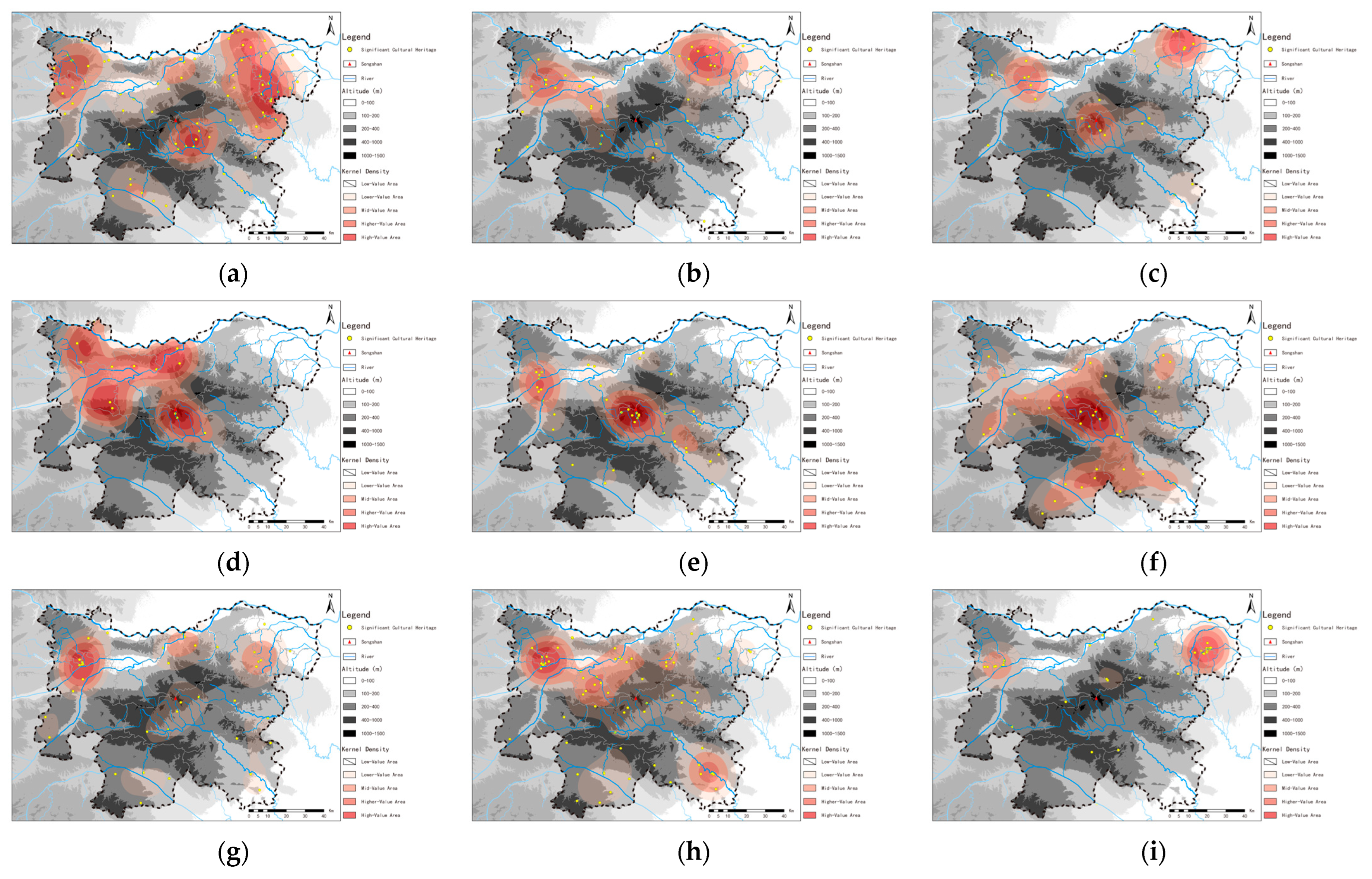
4.1.1. Prehistory Period

During the extensive prehistoric period, from 1,700,000 BC to 2000 BC, the spatial analysis reveals a pronounced clustering of high-grade cultural heritage sites in the region surrounding Mount Song. As quantified by the average nearest neighbor ratio of 0.831 (Table 1), this clustering is significantly more concentrated than random distribution would suggest. This statistical evidence supports the presence of dense cultural sites primarily in the northern sectors of the region, particularly around the urban centers of Luoyang, Dengfeng, Zhengzhou, and Xingyang (Figure 5a).
This distinct distribution pattern is intrinsically linked to the favorable natural geographic conditions of the area. The northern part of the region, enriched with a robust network of water systems and fertile agricultural land, provided optimal conditions for early human settlements and activities. Cities like Zhengzhou, Luoyang, and Dengfeng, situated along these advantageous environmental features, became focal points for sustained human habitation and cultural development.
Moreover, the aggregation of cultural sites in these areas not only delineates the historical cultural landscape but also emphasizes the central role of the Mount Song region in the early developmental phases of Chinese civilization. The prevalence of cultural heritage in these locations suggests that the accessibility of water and arable land were critical factors influencing where early communities thrived, leaving behind a rich tapestry of human activity and cultural remnants. This pattern underlines the hypothesis that geographical advantages played a decisive role in shaping the spatial distribution of cultural heritage, reflecting both the survival and the cultural evolution of early societies in the region.

4.1.2. Pre-Qin Period

During the pre-Qin period, from 2000 BC to 221 BC, the spatial configuration of high-grade cultural heritage sites continued to show significant clustering as evidenced by an average nearest neighbor ratio of 0.833 (Table 1). This ratio underscores a clear pattern of cultural concentration. The high-density clusters during this era were predominantly situated in Luoyang and Xingyang (Figure 5b). The Standard Deviational Ellipse distribution (Figure 6) reveals that the spatial characteristics of high-grade cultural heritage in the pre-Qin period closely followed the patterns established during the prehistoric period.
The northern part of the region surrounding Mount Song remained the principal area for the accumulation of cultural sites. The corridor stretching from Zhengzhou to Luoyang, incorporating Xingyang, and the urban areas of Zhengzhou and Luoyang, became increasingly significant. This area not only continued as a major center of cultural activity but also began to emerge more prominently as a centralized hub for political and economic interactions. Luoyang, in particular, solidified its status as a critical political, economic, and cultural center during this period, hosting a rich array of historical relics that underscore its pivotal role in early Chinese civilization.
The evolution of this spatial distribution pattern reflects the transition from scattered, diverse cultural practices of the earlier period to a more centralized and structured societal organization. The concentration of cultural heritage sites along this corridor indicates a trend toward consolidation of power and cultural activities, which likely facilitated the emergence of more complex societal structures and influenced the development of early statehood in China.

4.1.3. Qin and Han Period

During the Qin and Han dynasties, spanning from 221 BC to 220 AD, the spatial analysis of high-grade cultural heritage in the region surrounding Mount Song revealed a more concentrated clustering with an average nearest neighbor ratio of 0.718 (Table 1). This ratio indicates a significant increase in clustering compared with earlier periods. The three primary high-density clusters were identified in Luoyang and Dengfeng and at the northern junction between Zhengzhou and Xingyang (Figure 5c). The Standard Deviational Ellipse distribution (Figure 6) confirms that high-grade cultural heritage during the Qin and Han periods remained predominantly concentrated in the northern part of the region, maintaining the distribution patterns established during the pre-Qin period.
Luoyang, serving as the capital during the Eastern Han dynasty, emerged as a national epicenter of politics and culture, significantly influencing the concentration of cultural heritage sites. This period saw Luoyang evolve into a crucial cultural heritage core area, reflecting its enhanced status and the central government’s efforts to promote cultural prosperity. Moreover, the sites associated with significant historical events, such as Emperor Wu of Han’s tours of Mount Song and the famous Chu–Han contention, align with the locations of the other two high-density cultural heritage clusters. These associations underline the profound impact of the political and economic dynamics of the Qin and Han periods on the spatial distribution of cultural heritage sites.
This continued centralization of cultural heritage in the region underscores the evolving role of these areas as focal points for political power, cultural development, and economic activities. The clustering of cultural sites around Luoyang and nearby regions during this era not only highlights the city’s historical importance but also illustrates the broader cultural and political mechanisms that shaped the distribution of cultural heritage throughout early Chinese history.

4.1.4. Wei, Jin, Northern, and Southern Period

During the Wei, Jin, Southern, and Northern dynasties period, spanning from 220 AD to 589 AD, the region surrounding Mount Song continued to show a significant clustering of high-grade cultural heritage, with an average nearest neighbor ratio of 0.561 (see Table 1). This pronounced clustering indicates a compact distribution of cultural sites primarily in Luoyang, Dengfeng, Yanshi, and Gongyi, as illustrated in Figure 5d. The Standard Deviational Ellipse, detailed in Figure 6, shows that, during this era, high-grade cultural heritage was chiefly concentrated in the northwestern part of the region, particularly around Luoyang and its adjacent areas.
The strategic selection of Luoyang as the capital by both the Western Jin and Northern Wei dynasties significantly influenced the accumulation of cultural heritage in this area, leaving behind a dense collection of historical and cultural artifacts. Additionally, the unique geographical features of the region surrounding Mount Song—characterized by its natural barriers and strategic positioning—provided a fortified setting that likely contributed to the protection and preservation of cultural heritage during times of political and military turbulence.
The distribution of cultural heritage sites during this period was profoundly impacted by these cultural, political, and military dynamics. The continual use of Luoyang as a political center not only enhanced its cultural richness but also fostered the development of surrounding areas like Dengfeng, Yanshi, and Gongyi into significant cultural hubs. This spatial pattern underscores the intricate relationship between political history and cultural heritage preservation, reflecting how the strategic importance of the region influenced its cultural landscape.

4.1.5. Sui and Tang Period

During the Sui and Tang periods, from 589 AD to 960 AD, the spatial analysis of high-grade cultural heritage sites in the region surrounding Mount Song demonstrated distinct clustering, with an average nearest neighbor ratio of 0.613 (Table 1). This clustering is illustrated by two prominent high-density clusters located in Luoyang and Dengfeng (Figure 5e). The Standard Deviational Ellipse (Figure 6) reveals that high-grade cultural heritage during these periods was predominantly concentrated in the central part of the region, especially along the “Luoyang–Dengfeng” corridor. This spatial arrangement reflects the profound cultural development that occurred during a time of significant political stability and economic prosperity.
Luoyang’s role as the political, economic, and cultural hub was further solidified during the reign of Empress Wu Zetian. The city’s strategic importance and scenic beauty, nestled close to Mount Song, made it a focal point for historical and cultural activities. Particularly noteworthy were the Fengshan ceremonies conducted by Wu Zetian at Zhongyue (Central Sacred Mountain), which significantly enhanced the cultural richness of the area. These ceremonies, along with other imperial patronages and cultural endeavors, catalyzed the accumulation of a rich cultural heritage within this corridor, drawing scholars, artists, and religious figures to the region.
The distribution of cultural heritage sites during the Sui and Tang periods not only highlights the central role of Luoyang and Dengfeng but also illustrates how political decisions and cultural practices shaped the spatial cultural landscape. The enduring impact of these periods is evident in the continued prominence of these sites as centers of cultural heritage, reflecting their historical significance and the lasting legacy of the dynastic efforts to promote and preserve culture in proximity to Mount Song.

4.1.6. Song, Jin, and Yuan Period

During the Song, Jin, and Yuan period, from 960 AD to 1368 AD, the region surrounding Mount Song displayed pronounced spatial clustering of high-grade cultural heritage, with an average nearest neighbor ratio of 0.735 (Table 1). This clustering led to the formation of two distinct clusters in the area—one primary in Dengfeng and a secondary in Ruzhou (Figure 5f). According to the Standard Deviational Ellipse distribution (Figure 6), these significant cultural heritage sites were largely centralized in the central part of the region surrounding Mount Song.
Throughout the Northern Song period, Luoyang was designated as the Western Capital, marking the last historical phase during which the region served as a national capital. Subsequently, during this era, China’s political, economic, and cultural center gradually shifted eastward, away from the region surrounding Mount Song. This shift coincided with a period of significant social instability; after 70 years of Northern Song rule, the region fell under Jin control, only to be overtaken by the Mongols shortly thereafter. The Mongol Empire, despite its success in unifying China, did not focus on effective governance of this region or the country at large.
This period also marked a significant transition in cultural heritage development, shifting from royal-led construction projects to those initiated by civilians. This change is reflected in the architectural and cultural sites developed during this time, which were predominantly carried out by the local population without central directive. The spontaneously organized building activities underscore a shift in cultural dynamics and indicate a decentralization of cultural and political power, contributing to the diverse cultural heritage that characterizes this period. The resulting clusters in Dengfeng and Ruzhou illustrate the ongoing importance of these areas in maintaining cultural continuity despite the broader shifts in political centers.

4.1.7. Ming Dynasty

During the Ming dynasty, from 1368 AD to 1644 AD, the region surrounding Mount Song continued to demonstrate clear spatial clustering of high-grade cultural heritage, with an average nearest neighbor ratio of 0.855 (Table 1). Despite this clustering, the kernel density distribution (Figure 5g) indicates that the spatial distribution of cultural heritage during the Ming period was somewhat more dispersed compared with earlier dynasties. There remained a significant concentration of cultural sites in Luoyang, Dengfeng, Gongyi, Xingyang, and Zhengzhou, with Luoyang forming the primary cluster in its urban area. The Standard Deviational Ellipse distribution (Figure 6) further reveals a shift of high-grade cultural heritage toward the northern part of the region surrounding Mount Song.
The Ming era was marked by political stability and economic prosperity. During this period, although the region surrounding Mount Song ceased to be the national center of politics, economics, and culture, Luoyang retained its importance as the seat of Henan Prefecture, continuing to be a regional hub for these activities. This era witnessed substantial development in social productivity and an increase in civilian-led construction activities, contributing to the more dispersed distribution of significant cultural heritage sites. This broader spread reflects a pattern of decentralized development, as local communities and regional centers became increasingly empowered to initiate and manage cultural and construction projects. The enhanced dispersion of cultural sites during the Ming dynasty showcases a diversification in the locations of cultural significance within the area, underlining the ongoing cultural dynamism and regional importance despite shifts in national focus.

4.1.8. Qing Dynasty

During the Qing dynasty, which spanned from 1644 AD to 1911 AD, the spatial clustering of high-grade cultural heritage within the region surrounding Mount Song remained pronounced, as indicated by an average nearest neighbor ratio of 0.749 (Table 1). The primary cluster was notably prominent in Luoyang, while a significant secondary cluster developed in Yuzhou (Figure 5h). The Standard Deviational Ellipse distribution (Figure 6) suggests that the spatial distribution of cultural heritage during the Qing dynasty underwent little change compared with the Ming dynasty, maintaining a similar pattern of geographical concentration.
The Qing dynasty, recognized for its long duration and the complex social conditions of its later stages, saw Luoyang continuing its historical role as the political, economic, and cultural center of Henan Prefecture. This central role facilitated the further accumulation and preservation of high-grade cultural heritage within the area. Prominent landmarks from this period, such as the Luoyang Shanshan Guild Hall, Wenfeng Pagoda, and Henan Prefecture City God Temple, underscore the rich cultural tapestry of the region. Additionally, the era’s relative long-term stability and population growth spurred widespread construction activities across the region, perpetuating the pattern of multi-point development that had begun during the Ming dynasty.
This continuous development and the resulting cultural heritage reflect the complexity of the socio-economic and cultural dynamics throughout the Qing dynasty. The enduring concentration of significant cultural sites in Luoyang and its surrounding areas highlights the lasting impact of historical urban centers as focal points for cultural, economic, and social activities. The preservation of these sites offers invaluable insights into the historical continuity and cultural evolution of the region, underscoring the enduring influence of its historical significance.

4.1.9. Modern and Contemporary Times

In the modern era, stretching from 1911 AD to the present, the spatial analysis of important cultural heritage sites in the region surrounding Mount Song reveals intense clustering, as evidenced by an average nearest neighbor ratio of 0.550 (Table 1). This period has seen the development of a primary and a secondary core of cultural heritage concentration, with the primary core established in Zhengzhou and the secondary in Luoyang (Figure 5i). The Standard Deviational Ellipse distribution (Figure 6) indicates that, unlike during the Qing dynasty, important cultural heritage in the modern era is predominantly concentrated along the “Zhengzhou–Luoyang” axis in the northeastern part of the region.
This geographical shift in cultural heritage sites corresponds to significant socio-political changes in the region. In 1954, Zhengzhou was designated as the capital of Henan Province, positioning it as the new political, economic, and cultural hub of the region surrounding Mount Song. This shift has not only transformed Zhengzhou into the central node of modern historical and cultural heritage accumulation but also marked a broader shift in developmental focus within the region, emphasizing the growth and importance of major urban centers.
During this period, the cultural heritage primarily comprises sites related to revolutionary history, reflecting the transformative socio-political narratives of 20th-century China. In Luoyang, key heritage sites include the Former Site of the Eighth Route Army Luoyang Office, the Former Site of the Chen Xie Corps Journalism Training Class, and the Birthplace of the Communist Party of China Luoyang Branch. Meanwhile, Zhengzhou hosts significant sites, such as the Zhengzhou February 7th Strike Memorial Hall and the Memorial Cemetery of the Martyrs of the Second Group Army of the National Revolutionary Army during the Northern Expedition. These sites serve not only as cultural landmarks but also as poignant reminders of the region’s pivotal role in the historical events that shaped modern China.

4.2. Evolution Trends of the Centroid Model across Different Periods

Using the centroid model and Standard Deviational Ellipse tools in ArcGIS, we draw the directional distribution and centroid movement trends of high-grade cultural heritage in the region surrounding Mount Song across various historical periods. Figure 6 shows that, over nine historical periods, the centroid of important cultural heritage exhibits four distribution phases: from the northern part of the region surrounding Mount Song to the northwestern part, then to the central part, and finally to the northeastern part of the region. From the prehistoric period to the Qin and Han dynasties, the centroid of important cultural heritage was generally located in the northern part of the region surrounding Mount Song. During the Wei, Jin, Southern, and Northern dynasties period, the centroid shifted to the northwestern part of the region, moving a distance of 28.78 km. During the Sui and Tang periods, the centroid of important cultural heritage moved to the central part of the region surrounding Mount Song, with a movement distance of 22.84 km. Subsequently, up until the Qing dynasty period, the centroid of important cultural heritage, although slightly shifted, remained primarily in the central part of the region surrounding Mount Song. Since the modern era, the centroid of important cultural heritage has moved to the northeastern part of the region surrounding Mount Song, with a movement distance of 25.54 km. Overall, the positions of the centroids of important cultural heritage across different periods are highly correlated with the historical context and events of the region surrounding Mount Song during those times.

5. Influence of Environmental and Cultural Factor

5.1. Innate Factors: Natural Environment

The region surrounding Mount Song is located between 112°21′ E to 113°87′ E and 33°94′ N to 35°07′ N. It experiences a temperate continental monsoon climate with distinct seasons of spring, summer, autumn, and winter, where the rainy season coincides with the warmest temperatures. This area serves as a transitional zone between the second and third steps of China’s topography, featuring mountain ranges that are the eastern extensions of the Funiu Mountains, part of the Qinling Mountains system. These ranges spread out in a fan shape toward the northeast, east, and southeast. Between the mountain ranges, valleys are formed, which include the Yi-Luo River Valley to the west, the Ying River Valley in the center, and the North Ru River Valley to the south. The valley terrain primarily consists of plains and low hills, characterized by fertile soil and abundant water sources, making it suitable for agricultural production. The Yi-Luo River Valley and Ying River Valley areas are among the central regions where agriculture developed early in ancient China [33,34].
The region surrounding Mount Song is located in the transitional area from the western Henan mountains to the eastern Henan plains. The topography is complex and varied, with mountains, basins, river valleys, and plains intermingling, creating a rich natural landscape and unique regional characteristics. Within the region, the lowest elevation is 73 m, and the highest elevation reaches 1512 m. The elevations within the study area are divided into four levels from low to high. The number of high-grade cultural heritage sites decreases with increasing elevation (Table 2). The largest number of high-grade cultural heritage sites, totaling 239, is found below 200 m in elevation, accounting for 61% of the total. Only 42 sites are located above 400 m in elevation, comprising 11% of the total. This distribution reflects, to some extent, the shaping and influence of altitude on human settlement activities [35].
Rivers, integral to both the natural geographical environment and the development of civilizations, provide crucial resources such as water and fertile soil that support larger populations and extensive human construction activities. The Ying River, notable for its substantial water flow and minimal sediment, has historically enabled the construction of irrigation canals that support agriculture, creating an “ideal habitat” conducive to farming, grazing, and other subsistence activities [36].
Utilizing buffer analysis as described in our methodology, we assessed the spatial relationship between high-grade cultural heritage sites and river systems. The digital geographic hydrological model of the area shows that 265 high-grade cultural heritage sites, which represent 67.4% of the total, are located within 3 km on either side of the rivers (Figure 7). Notably, the majority of these sites, 139 in total and accounting for 35.4% of all sites, are found within just 1 km of the rivers (Table 3). This distribution highlights the profound impact rivers have on human activities and underscores the strong dependence of these activities on riverine resources [37].

5.2. Dominant Factors

5.2.1. Political Factors and Capital Establishment

The region surrounding Mount Song has played a pivotal role in China’s political landscape from the Neolithic era to the Northern Song period [38]. Its strategic geographical location at the heart of the Central Plains and its rich natural resources provided fertile ground for the emergence and development of early human settlements and, ultimately, for the flourishing of Chinese civilization [39].
During the Neolithic period, this region saw the rise of significant cultural developments with the Peiligang, Yangshao, Longshan, and Erlitou cultures. These cultures laid the foundational structures of Chinese civilization, marking the area as one of the first regions in China to advance into a structured societal setup [18]. Each culture contributed progressively to the region’s rich cultural tapestry, influencing subsequent eras. Historically, this region was the cradle for the Xia, Shang, and Zhou dynasties, each choosing it as their seat due to its strategic advantages. These dynasties transformed the area into a vibrant political and economic hub, fostering the development of ancillary cultural activities such as craftsmanship and trade [40]. The capitals established during these times became centers of intense cultural exchanges and artistic flourishing, which were integral to the cultural identity of ancient China. After the Eastern Han dynasty, Luoyang emerged as a prominent political center, maintaining its significance through the Cao Wei, Western Jin, and Northern Wei dynasties, spanning over three hundred years. This era of political prominence turned Luoyang into a melting pot of cultural activities. The city attracted a diverse array of people, from politically ambitious figures to artisans and traders, each adding layers to its cultural richness [41]. The political stability provided by these dynasties facilitated significant investments in monumental architecture and cultural projects, including the construction of the famed Longmen Grottoes, which began during the Northern Wei dynasty and continued to expand, reflecting the city’s importance as a Buddhist center. The political stability under these dynasties created favorable conditions for economic prosperity, which in turn supported and enriched the cultural landscape. The flourishing economy allowed for the patronage of arts and the preservation of important cultural sites. Pilgrims, scholars, and tourists drawn to the city by its cultural significance contributed economically, creating a feedback loop where economic prosperity fed into cultural preservation [42]. The political shifts during the Five Dynasties period saw a decline in Luoyang’s primary status as the political center shifted eastward. Despite this, Luoyang’s historical and cultural significance allowed it to remain a vital military and cultural stronghold. Even as the national political and economic centers moved southward after the Southern Song period, Luoyang’s legacy as a former capital continued to influence local and regional cultural heritage conservation efforts [43].
Throughout its extensive history, the region surrounding Mount Song has demonstrated how political centrality can profoundly influence cultural and economic development. The establishment of various dynastic capitals in this region not only shaped its political landscape but also laid a rich cultural foundation that endured beyond the reigns of these dynasties [44]. Each period of stability under different rulers allowed for the blossoming of cultural and economic activities that have left an indelible mark on the region’s heritage.

5.2.2. Cultural and Religious Factors

The Heluo culture, originating in the region surrounding Mount Song, is a core component of the Yellow River civilization represented by the Central Plains culture and has been a mainstay and core of traditional Chinese culture for thousands of years [45]. During the mythical era of Fuxi, the “Hetu” (River Map) emerged on the back of a dragon-horse from the Yellow River at Mengjin, Luoyang; during the time of Yu the Great, the “Luoshu” (Book of Luo) appeared on the back of a divine turtle in the Luo River. Fuxi used the Hetu to develop the eight trigrams, and Yu used the Luoshu to define the regions of China. Hetu and Luoshu are considered origins of the Confucian and Taoist classic, the I Ching (Book of Changes) [46]. Starting from the Eastern Zhou period, Confucian thought began to sprout in this region. By the Spring and Autumn and Warring States periods, Confucianism gradually became the dominant ideology of the ruling class. During the Eastern Han, the Imperial University was established in Luoyang to promote Confucian education, nurturing a large number of Confucian scholars. During the Sui and Tang periods, with Luoyang serving as a political and cultural center, Confucianism was further strengthened and revered, deeply embedding Confucian rituals and political and moral concepts into society [47]. In the Song dynasty, the founders of “Luoxue” (the Luoyang School of Thought), Cheng Hao and Cheng Yi, gathered and lectured at the Songyang Academy located on the southern slopes of Mount Song’s Taishi Mountain. The Songyang Academy became an important venue for the teaching and dissemination of Confucian thought during the Song dynasty and the birthplace of the “Neo-Confucianism of the Cheng Brothers” [48].
The period from the Han to the Song dynasties marks an important stage in the Chinese Middle Ages of agricultural civilization, as well as a flourishing period for Buddhism and Taoism in the region surrounding Mount Song. Buddhism was introduced to China during the Han Dynasty, and the White Horse Temple was the first temple built following its introduction, marking the beginning of the localization process of Buddhism in China. Luoyang, serving as the political, economic, and cultural center of the Eastern Han dynasty, naturally became one of the centers for the spread of Buddhism. In the third year of the Xiaochang era (527 AD) under Emperor Xiaoming of the Northern Wei dynasty, Bodhidharma, the Buddhist patriarch, arrived at Shaolin Temple on Mount Song’s Shaoshi Mountain. Building upon the foundation set by the Indian monk Batuo, he expanded the temple and gathered a large following, and Shaolin Temple gradually became the ancestral home of Zen Buddhism. Mount Song, known as Zhongyue, is considered a sacred Taoist site. Since the Han dynasty, it has been a place of cultivation for numerous practitioners and hermits, and numerous Taoist temples and shrines have been extensively constructed there. During the Sui and Tang periods, Taoism reached its peak in the Mount Song area, with a significant increase in the number of Taoist temples, making it a center for the dissemination of Taoist doctrines. Therefore, it can be said that the region surrounding Mount Song is the birthplace of traditional Chinese philosophical thought, a center for the exchange and dissemination of Confucian ideas, and a core area where Taoism and Buddhism flourished. Especially notable is the convergence of Confucian, Taoist, and Buddhist thoughts, which has formed a cultural mindset characterized by “moderation”. This mindset has long influenced the orientation of Chinese cultural values and maintained a dominant position in the moral philosophy of successive dynasties [38].

5.3. Secondary Factors

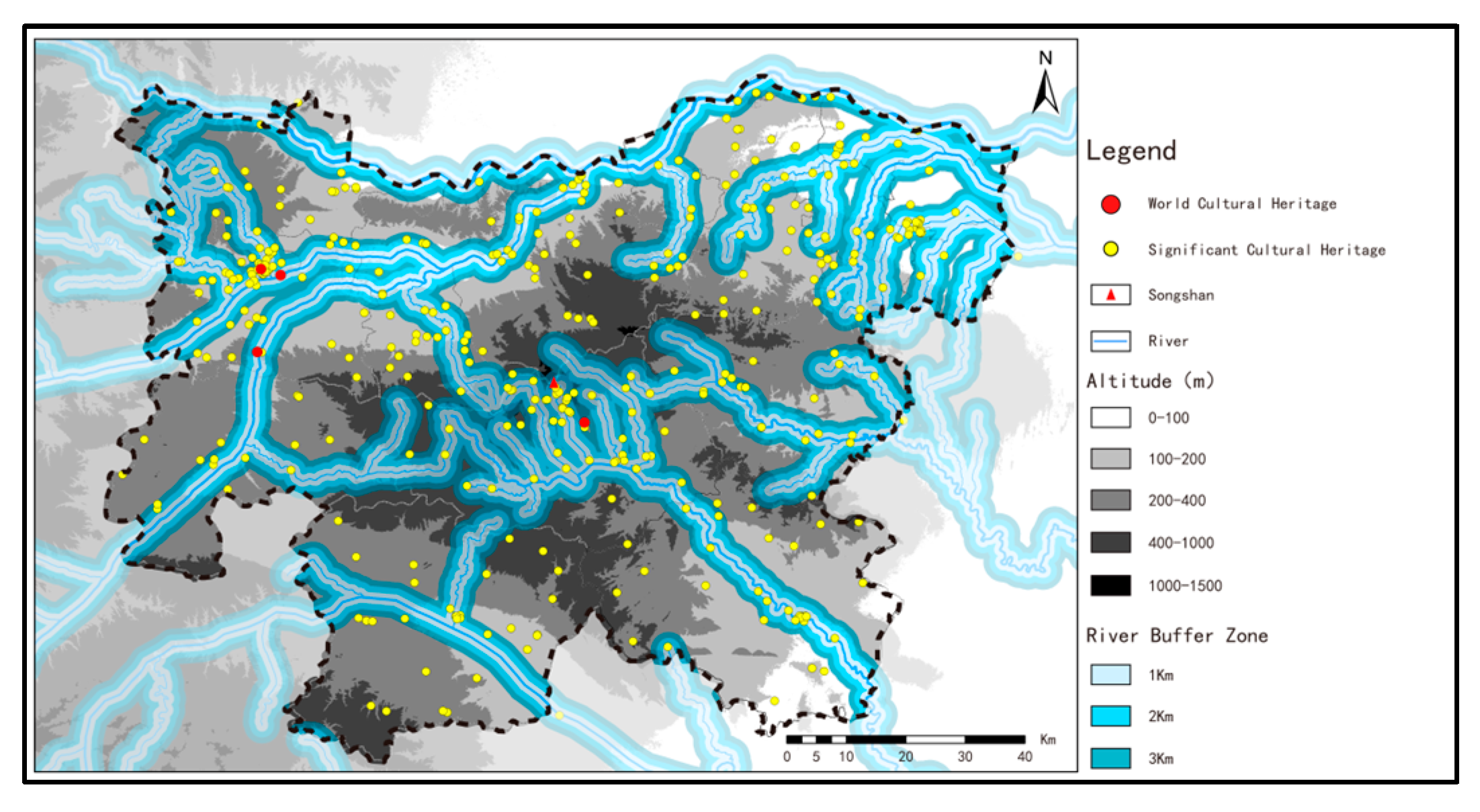
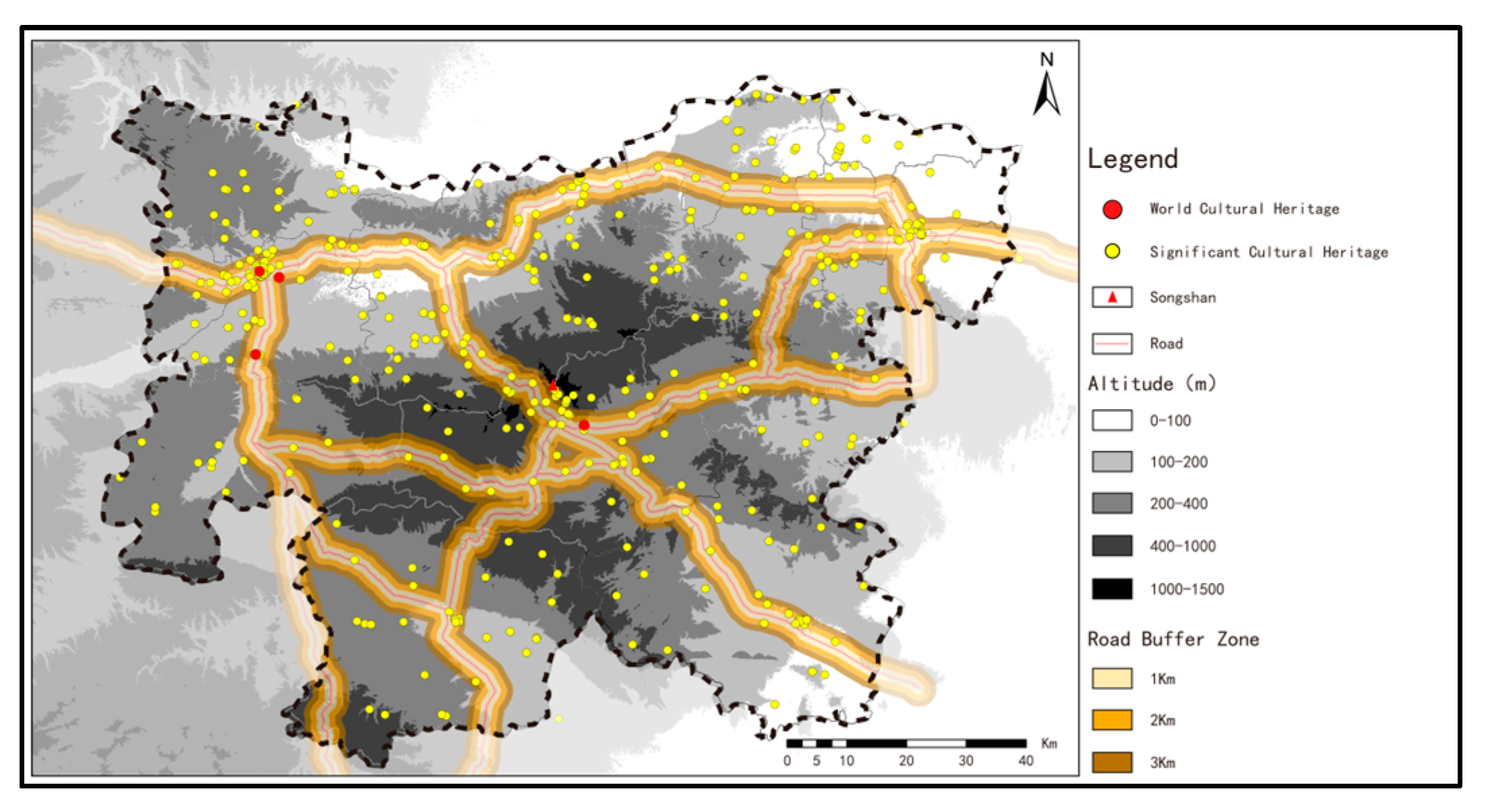
5.3.1. Land and Water Transportation

Roads and rivers are vital conduits for connecting different regions, facilitating the movement of people and the transportation of goods. On one hand, the formation and development of transportation routes are closely related to the political, economic, and cultural dynamics within a certain area. On the other hand, stable transportation routes, serving as links for external exchange, greatly promote the formation of diversity and richness in the cultural heritage of the region. Rivers have been one of the earliest and most cost-effective means of transportation and goods movement that humans have long relied upon. The “Annals of Xia” in the Records of the Grand Historian states, “In Yuzhou, one could float on the Luo and reach the Yellow River”. This indicates that, in early China, people had already navigated other rivers to access the Yellow and Luo Rivers, initially exploring a water transport blueprint centered around these river systems. This means that the Yi-Luo River, as an important tributary of the Yellow River, was a crucial transportation waterway in ancient times. It was through this “golden waterway” that key resources from the surrounding areas, such as minerals and salt, could be transported to the capital region of the Yi-Luo River Basin [29].
After the Qin and Han dynasties, the development and utilization of the Yellow River’s waterways were closely associated with the excavation of the Sanmen Gorge. During the Western Han period, millions of dan (a traditional Chinese unit of grain measurement, approximately 100 L per dan) of grains were transported annually to Chang’an. During the Eastern Han dynasty, Luoyang served as the national center for grain transportation, with the Yellow River being the main waterway leading into the city. In the first year of the Daye era (605 AD) of the Sui dynasty, Emperor Yang of Sui mobilized over a million people from the counties of Henan and northern Huai to construct the Jiqu Canal. By the fourth year of the Daye era (608 AD), Emperor Yang issued a decree to mobilize another million men and women from the counties of Hebei to open the Yongji Canal. The new Grand Canal connected the five major water systems of the Qiantang River, Yangtze River, Huai River, Yellow River, and Hai River for the first time, significantly promoting economic and cultural exchanges between the northern and southern regions of China. During the Sui and Tang dynasties, granaries were established both upstream and downstream of the Sanmen Gorge. To circumvent the perilous Sanmen pass, a method of “reversing warehouses” over land routes was employed, allowing grain boats with a capacity of 600 dan to navigate from Luoyang to Chang’an. From the Song and Yuan dynasties through to the Ming and Qing dynasties, the Yellow River waterway remained an important transportation route for the western Henan region [49].
Luoyang, situated at “the center of the world”, has long served as a national transportation hub, occupying a very important position in the history of ancient Chinese transportation [49]. After the Eastern Zhou dynasty established its capital in Luoyang in 770 BC, six major roads were constructed radiating from Luoyang to various parts of the country. Among these, the Eastern Road went through Luorui (now located near Gong County in Luokou) to Mingtiao (now southwest of Changyuan) and extended to the Yangtze River and Huai River basins. After Qin Shi Huang unified the six states, the Eastern Road passed through Hangu Pass, Mianchi, Luoyang, Xingyang, and Bolangsha (now in Yuanyang County) to reach Shandong. The east–west Luoyang–Kaifeng postal route, established during the Sui and Tang dynasties, is still in use today [50]. Xuanyuan Road is a major transportation artery from Luoyang to the southeast, passing through Yanshi Gushi and Dengfeng Xuanyuan Pass. It leads to places like Dengfeng, Yuzhou, Xuchang, and Nanyang, and is known as the “Eastern Route of the Ancient Wanluo Road” [51]. In the digital geographic transportation system model of the area, there are 191 high-grade cultural heritage sites located within 3 km of important ancient roads (Figure 8), accounting for 48.6% of the total. Among these, the highest number, 88 sites, are distributed within 1 km of the roads, making up 22.4% of the total. The number of sites decreases as the distance from the road increases (Table 4).

5.3.2. Fengshan Ceremony at Mount Song

Chinese mountain culture, represented by the Five Sacred Mountains, is a product of ancient mountain god worship and imperial rituals known as Fengshan. Mount Song, as one of the Five Great Mountains, has been a significant sacred site for imperial tours and sacrifices since the Xia, Shang, and Zhou dynasties. After King Ping of the Eastern Zhou dynasty moved the capital to Luoyang, Mount Song was referred to as the ancestral mountain. During the Spring and Autumn and Warring States periods, Mount Song was considered the foremost among mountains and was worshipped with the highest rites reserved for the emperor, known as the “Grand Sacrifices of the Son of Heaven”. Following the establishment of the Five Sacred Mountains system during the Han dynasty, imperial rituals at Mount Song were formalized and institutionalized. From the Han to the Sui and Tang dynasties, most dynasties conducted these rituals annually, or multiple times a year, especially during significant events such as imperial ascensions, natural disasters, or other major incidents, requiring the emperor to personally, visually, or through emissaries perform the sacrifices. These activities not only solidified Mount Song’s status as a “sacred mountain” for the Chinese nation but also made the Yue sacrifice culture a paradigm of ancient Chinese ritual culture.
Emperors’ tours, sacrifices, and Fengshan ceremonies at Mount Song have left a rich cultural heritage in the region. In the first year of Yuanfeng during the Western Han dynasty (110 BC), Emperor Wu of Han toured Mount Song, built the Taishi Shrine for worshipping the mountain gods, and allocated 300 households specifically for the worship of the mountain deities, initiating the ritual system of the Five Sacred Mountains. According to the Old Book of Tang: Records of Rites, during the reign of Empress Wu Zetian in 695 AD, the empress decreed preparations for sacrifices at the Qi Mu Temple and Shaoyi Temple and personally led civil and military officials to Mount Song for an unprecedented and grand Fengshan ceremony, elevating Mount Song to the most revered of the Five Sacred Mountains [52]. From the Han to the Tang dynasties, emperors would depart from Xi’an or Luoyang to tour and offer sacrifices at Mount Song, following the Xuanyuan Ancient Road through Xuanyuan Pass. Before the Tang dynasty, this road was extremely perilous. During the time of Emperor Gaozong of Tang, the road was widened to allow two-way travel, facilitating easier access to Mount Song for imperial sacrifices.

5.3.3. Impact of Invasions and Upheavals on Population Density and Cultural Site Utilization

Historical events, particularly invasions and social upheavals, have played a significant role in shaping the demographic and cultural landscapes of the region surrounding Mount Song. These events have influenced both the density of populations and the usage of cultural heritage sites, with lasting impacts on the region’s cultural legacy.
The An Lushan Rebellion caused widespread destruction and led to significant population displacement. As northern cities like Luoyang faced devastation, many inhabitants fled to safer southern areas, causing a drastic reduction in population density. The cultural sites in these cities, once bustling centers of Tang dynasty culture, saw periods of neglect and disrepair due to the reduced local population and diminished maintenance [53]. However, after the rebellion, these sites experienced phases of reconstruction and rejuvenation as stability was gradually restored, highlighting the resilience of cultural heritage amidst adversity. The Jingkang Incident calamity saw the fall of the Northern Song capital, Kaifeng, to Jin dynasty forces, triggering a mass migration southward to cities like Hangzhou. The cultural heritage sites in Kaifeng were largely abandoned and fell into neglect, while Hangzhou saw a cultural boom, becoming a new center for Song Dynasty arts and culture. This shift not only altered the cultural prominence of these cities but also underscored the mobility of cultural capital in response to political and military crises.
These historical examples illustrate how demographic shifts caused by invasions and upheavals directly impacted the utilization and condition of cultural heritage sites in the region surrounding Mount Song [54]. Understanding these patterns is crucial for contemporary cultural heritage conservation efforts. Recognizing the factors that led to the abandonment or preservation of these sites can guide modern conservation strategies and urban development planning. By learning from the past, policymakers and conservationists can develop more effective measures to protect these invaluable cultural assets, ensuring that they remain integral parts of the community’s cultural and historical identity. This revised subsection now provides a more detailed and historically grounded discussion of how major upheavals impacted cultural heritage sites, aligning with the feedback from Reviewer A to expand on historical interpretations and their relevance to current urban development and conservation strategies.

6. Conclusion and Discussion

6.1. Temporal and Spatial Patterns

The high-grade cultural heritage in the region surrounding Mount Song not only exhibits clear temporal continuity but also demonstrates significant spatial clustering. This clustering varies, with a general pattern of greater density in the north compared with the south, notably in Luoyang, Dengfeng, and Zhengzhou. Throughout the nine historical periods analyzed, these distributions have shown consistent clustering, with notable shifts in the centroid of cultural heritage locations, reflecting historical shifts in political and cultural centers.

6.2. Influencing Factor

Multiple factors influence the region’s rich cultural heritage. The superior geographical environment, abundant resources, and stable water transportation systems have all played roles. The region’s status as a national political center through various historical periods, coupled with its significance in the development of Chinese philosophical thought, particularly Confucianism, Taoism, and Buddhism, underscores its cultural depth. The historical imperial tours, sacrifices, and Fengshan ceremonies further enrich this cultural landscape.

6.3. Recommendations for Conservation

To ensure the protection of significant cultural heritage sites, urban development in China must prioritize the integration of heritage conservation into city planning processes. Development projects should be aligned with existing protection plans for cultural relics, explicitly avoiding areas identified as having high cultural value. This can be achieved by mandating comprehensive archaeological assessments before construction begins and enforcing strict zoning laws that prohibit development near key heritage sites. Such measures will help maintain the integrity of these areas and prevent potential damage during urban expansion. Internationally, projects such as the relocation of high-speed train stations in France to protect historical sites, or the rerouting of pipelines in North America to preserve indigenous lands, exemplify how infrastructure development can accommodate cultural heritage conservation. These examples serve as models for how similar principles can be applied in the context of China’s urban development [55].
A structured, tiered approach to conservation, termed “zones—corridors—units”, is recommended to enhance the management and preservation of the region’s cultural heritage. This approach involves creating protected zones that encompass significant heritage clusters, establishing corridors to connect these zones and ensure ecological and cultural continuity, and defining specific units for focused conservation efforts. Each tier should be customized to address the unique needs and historical significance of the area it covers, as suggested by the spatial patterns identified through kernel density mapping. This holistic strategy facilitates a comprehensive management framework that supports both the conservation and the sustainable development of the region.
Local governments should take an active role in the sustainable utilization of cultural heritage resources. This includes developing responsible tourism programs that educate and engage visitors without compromising the heritage sites’ integrity. Community involvement should be encouraged, promoting cultural heritage as a cornerstone of local identity and pride. Furthermore, educational initiatives and public awareness campaigns are crucial for instilling a stewardship mentality among residents and visitors, ensuring that heritage conservation is seen as both a privilege and a responsibility. These efforts will help to harness the educational and economic potentials of cultural heritage, ultimately contributing to the region’s social and economic sustainability.

6.4. Methodological Reflections and Future Research

Despite the robust spatial pattern analysis methods utilized, such as ArcGIS, it is acknowledged that these tools provide only a partial reflection of the comprehensive spatiotemporal dynamics at play. Future research should incorporate more advanced methodologies, such as remote sensing and machine learning, to enhance the accuracy of our findings. Moreover, adopting an interdisciplinary approach that marries GIS with historical and cultural analyses will offer a richer, more nuanced understanding of how past legacies influence present and future landscapes.

Author Contributions

F.W.: Responsible for literature search and manuscript revision. C.S.: Responsible for research design, data collection and analysis, figure preparation, data interpretation, and drafting of the manuscript. J.M.: Responsible for data validation and manuscript revision. All authors have read and agreed to the published version of the manuscript.

Funding

This research received no external funding.

Data Availability Statement

All research data obtained during this study are included in this article. The raw data are available upon request.

Conflicts of Interest

The authors declare that they have no competing interests.

References

  1. Li, L.; Yue, T. Towards the Contemporary Conservation of Cultural Heritages: An Overview of Their Conservation History. Heritage 2024, 7, 175–192. [Google Scholar] [CrossRef]
  2. Moustafa, L.H. Cultural Heritage and Preservation: Lessons from World War II and the Contemporary Conflict in the Middle East. Am. Arch. 2016, 79, 320–338. [Google Scholar] [CrossRef]
  3. Browne, K.; Raff, M. The Emergence of the International Protection of Cultural Heritage. In International Law of Underwater Cultural Heritage; Springer: Cham, Switzerland, 2022. [Google Scholar] [CrossRef]
  4. Blake, J. Convention for the Safeguarding of Intangible Cultural Heritage (2003). In Encyclopedia of Global Archaeology; Smith, C., Ed.; Springer: Cham, Switzerland, 2020. [Google Scholar] [CrossRef]
  5. Maclaren, F.T. China: Cultural Heritage Preservation and World Heritage. In Encyclopedia of Global Archaeology; Smith, C., Ed.; Springer: Cham, Switzerland, 2020. [Google Scholar] [CrossRef]
  6. Yu, H.; Verburg, P.H.; Liu, L.; Eitelberg, D.A. Spatial Analysis of Cultural Heritage Landscapes in Rural China: Land Use Change and Its Risks for Conservation. Environ. Manag. 2016, 57, 1304–1318. [Google Scholar] [CrossRef] [PubMed]
  7. Luo, H.; Ma, X. Restoring ancient civilizations through cultural heritage conservation science. Sci. China Technol. Sci. 2023, 66, 2161. [Google Scholar] [CrossRef]
  8. Zhang, S. The development and institutional characteristics of China’s built heritage conservation legislation. Built Herit. 2022, 6, 11. [Google Scholar] [CrossRef]
  9. Li, K. Traditional Rural Heritage Conservation in China: Policies and Theories. In A Morphological Interpretation of a Northern Chinese Traditional Village; Springer: Singapore, 2024. [Google Scholar] [CrossRef]
  10. Huang, Y.; Yang, S. Spatio-temporal evolution and distribution of cultural heritage sites along the Suzhou canal of China. Herit. Sci. 2023, 11, 188. [Google Scholar] [CrossRef]
  11. Xie, Y.; Yang, R.; Liang, Y.; Li, W.; Chen, F. The Spatial Relationship and Evolution of World Cultural Heritage Sites and Neighbouring Towns. Remote Sens. 2022, 14, 4724. [Google Scholar] [CrossRef]
  12. Sun, Y.; Wang, Y.; Liu, L.; Wei, Z.; Li, J.; Cheng, X. Large-scale cultural heritage conservation and utilization based on cultural ecology corridors: A case study of the Dongjiang-Hanjiang River Basin in Guangdong, China. Herit. Sci. 2024, 12, 44. [Google Scholar] [CrossRef]
  13. Gordon, J.E. Geoheritage, Geotourism and the Cultural Landscape: Enhancing the Visitor Experience and Promoting Geoconservation. Geosciences 2018, 8, 136. [Google Scholar] [CrossRef]
  14. Su, B. Ancient Cultures, Cities, and States of Western Liaoning—Discussing the Current Priorities or Major Topics in Field Archaeology. Cult. Relics 1986, 8, 41–44. [Google Scholar]
  15. Chen, C. Discussing the Reconstruction of Ancient History through the Progress in Archaeological Theory and Methods. Hist. Res. 2018, 6, 4–20. [Google Scholar]
  16. Wang, W.; Zhao, H. The ‘Chinese Civilization Exploration Project’ and Its Main Achievements. Chin. Hist. Res. 2022, 4, 5–32. [Google Scholar]
  17. Zhou, K. Fifteen Years of Chinese Environmental Archaeology. In Environmental Archaeology Research; Zhou, K., Mo, D., Eds.; Peking University Press: Beijing, China, 2006; Volume 3, pp. 12–26. [Google Scholar]
  18. Zhou, K.; Zhang, S.; Zhang, Z.; Yang, R.; Cai, Q.; Song, G.; Song, Y.; Mo, D.; Wang, H.; Lu, P.; et al. Discussion on the Songshan Cultural Circle. Cent. Plains Cult. Relics 2005, 1, 12–20. [Google Scholar]
  19. Lu, P.; Liu, W.; Yang, R.; Zhou, K.; Chen, P. Three-Dimensional Visualization Analysis of the Prehistoric Settlement Distribution and Environment in the Songshan Region. Reg. Res. Dev. 2011, 30, 157–160. [Google Scholar]
  20. Lu, P.; Tian, Y.; Chen, P.; Mo, D. Study on the Spatiotemporal Patterns of Prehistoric Settlement Distribution in the Songshan Region. Acta Geogr. Sin. 2016, 71, 1629–1639. [Google Scholar]
  21. Yan, L.; Shi, Y.; Yang, R. Study on the Division of Prehistoric Settlement Clusters in the Songshan Region. Reg. Res. Dev. 2015, 34, 172–176. [Google Scholar]
  22. Yan, L.; Shi, Y.; Lu, P.; Liu, C. Study on the Relationship between Settlement Site Selection and Water Systems in the Songshan Region During the Prehistoric Period. Reg. Res. Dev. 2017, 36, 169–174. [Google Scholar]
  23. Yan, L.; Zhang, Y.; Lu, P.; Chen, P.; Zhang, L.; Wang, X. Study of Early Settlement Size Hierarchy Based on K-means Clustering Method. Reg. Res. Dev. 2020, 39, 176–180. [Google Scholar]
  24. Tang, L.; Li, F.; Gu, W.; Wu, Q. Agricultural Evolution in the Songshan Region During the Longshan to Erlitou Period. Huaxia Archaeol. 2019, 3, 58–66. [Google Scholar]
  25. Gao, F.; Wu, Y. Rice and Power: Utilization of Rice from the Longshan to Erlitou Cultural Periods in the Songshan Region. South. Cult. Relics 2022, 2, 135–144. [Google Scholar]
  26. Qin, C.; Yuan, G. Research and Related Issues of Peiligang Culture from the Perspective of Scientific Archaeology. Jianghan Archaeol. 2022, 1, 97–105. [Google Scholar]
  27. Lu, P.; Tian, Y.; Yang, R. Settlement Size Hierarchy in the Songshan Region from 9000 aB.P.-3000 aB.P. Acta Geogr. Sin. 2012, 67, 1375–1382. [Google Scholar]
  28. Zhengzhou Songshan Ancient Architectural Group Declaration Office (Ed.) Songshan Historical Architectural Group; Science Press: Beijing, China, 2008; p. 241. [Google Scholar]
  29. Liu, L.; Chen, X. Formation of Early States in China: Discussing the Relationships between Centers and Peripheries during the Erlitou and Erligang Periods. Anc. Civiliz. 2002, 1, 71–134. [Google Scholar]
  30. Dai, X. Phasal Changes in China’s Prehistoric Society and the Formation of Early States. Acta Archaeol. Sin. 2020, 3, 309–336. [Google Scholar]
  31. State Council of the PRC. Available online: http://www.scopsr.gov.cn/ (accessed on 9 October 2024).
  32. Henan Provincial Administration of Cultural Heritage. Available online: http://www.wwj.henan.gov.cn (accessed on 9 October 2024).
  33. Yang, F.; Duan, Q.; Cheng, B.; Ren, G.; Jia, Y.; Jin, G. The Agriculture and Society in the Yiluo River Basin: Archaeobotanical Evidence from the Suyang Site. Front. Earth Sci. 2022, 10, 885837. [Google Scholar] [CrossRef]
  34. Li, Y.; Zhang, J.; Zhang, X.; Zhao, H. Agriculture, the Environment, and Social Complexity from the Early to Late Yangshao Periods (5000–3000 BC): Insights from Macro-Botanical Remains in North-Central China. Front. Earth Sci. 2021, 9, 662391. [Google Scholar] [CrossRef]
  35. Zhang, S. (Ed.) Population Vertical Distribution Patterns and Research on the Rational Redistribution of Population in China’s Mountainous Areas; East China Normal University Press: Shanghai, China, 1996. [Google Scholar]
  36. Henan Provincial Institute of Cultural Relics and Archaeology; Department of Anthropology at Missouri State University; Department of Anthropology at Washington University (Eds.) Ying River Civilization: Archaeological Survey and Research on the Upper Ying River; Elephant Press: Zhengzhou, China, 2008; p. 49. [Google Scholar]
  37. Haidvogl, G. Historic Milestones of Human River Uses and Ecological Impacts. In Riverine Ecosystem Management; Schmutz, S., Sendzimir, J., Eds.; Aquatic Ecology Series; Springer: Cham, Switzerland, 2018; Volume 8. [Google Scholar] [CrossRef]
  38. Han, G. Leadership and Integration: The Process of Civilization in Ancient China from the Perspective of Songshan Civilization. In Research on the Origins of Chinese Civilization and Songshan Civilization; Zhengzhou China Origins and Songshan Civilization Research Association, Ed.; Science Press: Beijing, China, 2013; Volume 1, pp. 197–212. [Google Scholar]
  39. Yan, L.; Yang, R.; Lu, P.; Teng, F.; Wang, X.; Zhang, L.; Chen, P.; Li, X.; Guo, L.; Zhao, D. The spatiotemporal evolution of ancient cities from the late Yangshao to Xia and Shang Dynasties in the Central Plains, China. Herit. Sci. 2021, 9, 124. [Google Scholar] [CrossRef]
  40. Liu, L. The Xia-Shang-Zhou Civilization. In The History of Chinese Civilization. China Insights; Bu, X., Ed.; Springer: Singapore, 2023. [Google Scholar] [CrossRef]
  41. Fu, C.; Cao, W. The Evolvement and Development of Luoyang. In Introduction to the Urban History of China; China Connections; Palgrave Macmillan: Singapore, 2019. [Google Scholar] [CrossRef]
  42. Luoyang Municipal Local Chronicles Compilation Committee (Ed.) Chronicles of Luoyang City, (Cultural Relics); Zhongzhou Ancient Books Publishing House: Zhengzhou, China, 1995; Volume 14, pp. 1–7. [Google Scholar]
  43. Fu, C.; Cao, W. Cities During the Five Dynasties and the Ten Kingdoms Period, and the Turning Point of Chinese Urban History. In Introduction to the Urban History of China; China Connections; Palgrave Macmillan: Singapore, 2019. [Google Scholar] [CrossRef]
  44. Ge, Z. Tang-Song or Song-Ming: The Significance of a Perspective Shift in Chinese Cultural and Intellectual History. Front. Hist. China 2006, 1, 61–83. [Google Scholar] [CrossRef]
  45. Zhang, X. Discussion and Reflections on Several Issues of Heluo Culture. Zhongzhou Acad. J. 2004, 5, 146–150. [Google Scholar]
  46. Smith, R.J. Divination: Science, Technology, and the Mantic Arts in Traditional China. In Encyclopaedia of the History of Science, Technology, and Medicine in Non-Western Cultures; Selin, H., Ed.; Springer: Dordrecht, The Netherlands, 2016. [Google Scholar] [CrossRef]
  47. Knapp, K.N. Early Imperial Confucianism. In The Oxford Handbook of Confucianism; Oldstone-Moore, J., Ed.; Online, Edn; Oxford Academic: Oxford, UK, 2023. [Google Scholar] [CrossRef]
  48. Ren, W.; He, Y. The Songyang Academy of Classical Learning: A Frontier of New Confucianism. In Historic Monuments of Mount Songshan; Springer: Singapore, 2021. [Google Scholar] [CrossRef]
  49. Luoyang Municipal Local Chronicles Compilation Committee (Ed.) Chronicles of Luoyang City 1991–2000; Zhongzhou Ancient Books Publishing House: Zhengzhou, China, 2006; Volume 1, pp. 1–32. [Google Scholar]
  50. Zhengzhou Municipal Local Chronicles Compilation Committee (Ed.) Chronicles of Zhengzhou City, Part 1; Zhongzhou Ancient Books Publishing House: Zhengzhou, China, 1999; pp. 1–12. [Google Scholar]
  51. Henan Provincial Transportation History Compilation Committee (Ed.) History of Road Transport in Henan; People’s Transportation Publishing House: Beijing, China, 1991; Volume 1, p. 30. [Google Scholar]
  52. Dengfeng Municipal Local Chronicles Compilation Committee (Ed.) Chronicles of Dengfeng City; Zhongzhou Ancient Books Publishing House: Zhengzhou, China, 2008; Volume 1, pp. 196–202. [Google Scholar]
  53. von Richard, G. Economic Transformation in the Tang-Song Transition (755 to 1127). In The Economic History of China: From Antiquity to the Nineteenth Century; Cambridge University Press: Cambridge, UK, 2016; pp. 208–254. [Google Scholar]
  54. Xu, Z.; Tian, G.; Wei, K.; Ma, Y.; Zhang, S.; Huang, Y.; Yao, X. The Influence of Environment on the Distribution Characteristics of Historical Buildings in the Songshan Region. Land 2022, 11, 2094. [Google Scholar] [CrossRef]
  55. Hyeon-Joo, L. The Influence of High-Speed Railroad Construction on Territorial Organization: A Case Study of the French TGV Transportation Network. J. Korean Assoc. Reg. Geogr. 2004, 10, 252–266. [Google Scholar]
Figure 1. Comparative map of the region surrounding Mount Song.
Buildings 14 03259 g001
Figure 2. The scope of the surrounding Songshan area.
Buildings 14 03259 g002
Figure 3. Location of the Songshan region within the eight major prehistoric cultural areas of China (source: drawn based on reference [19]: p. 92, reference [20]: p. 310).
Buildings 14 03259 g003
Figure 4. Kernel density map of the spatiotemporal distribution of all significant cultural heritages.
Buildings 14 03259 g004
Figure 5. Kernel density map of the spatiotemporal distribution of significant cultural heritage across all periods. (a) prehistory period; (b) pre-Qin period; (c) Qin and Han period; (d) Wei, Jin, Northern, and Southern period; (e) Sui and Tang period; (f) Song, Jin, and Yuan period; (g) Ming dynasty; (h) Qing dynasty; and (i) modern and contemporary times.
Buildings 14 03259 g005
Figure 6. Trend map of the evolution of centroids of significant cultural heritage across different periods in the surrounding Songshan area.
Buildings 14 03259 g006
Figure 7. Distribution of river buffer zones and significant cultural heritage in the surrounding Songshan area.
Buildings 14 03259 g007
Figure 8. Distribution of road buffer zones and significant cultural heritage in the surrounding Songshan area.
Buildings 14 03259 g008
Table 1. Average nearest neighbor results for “cultural relics protection units at the provincial level or above” in the surrounding Songshan area.
PeriodActual Nearest Neighbor Distance (km)Theoretical Nearest Neighbor Distance (km)Nearest Neighbor IndexSpatial Distribution Characteristics
Prehistory period
(1,700,000 BC to 2000 BC)
5.706.850.831Relatively Clustered
Pre-Qin period
(2000 BC to 221 BC)
7.879.450.833Relatively Clustered
Qin and Han period
(221 BC to 220 AD)
8.8012.250.718Clustered
Wei, Jin, Northern, and Southern period
(220 AD to 589 AD)
9.1816.370.561Clustered
Sui and Tang period
(589 AD to 960 AD)
5.949.680.613Clustered
Song, Jin, and Yuan period
(960 AD to 1368 AD)
7.5010.210.735Clustered
Ming dynasty
(1368 AD to 1644 AD)
8.389.810.855Relatively Clustered
Qing dynasty
(1644 AD to 1911 AD)
5.307.070.749Clustered
Modern and contemporary times
(1911 AD to the present)
5.469.930.550Clustered
Table 2. Elevation and quantity of high-grade cultural heritage.
Elevation DataNumber of High-Grade Cultural Heritage Sites
1 (0–200 m)239
2 (200–400 m)112
3 (400–1000 m)32
4 (Above 1001 m)10
Table 3. River buffer zones and quantity of high-grade cultural heritage.
River Buffer ZonesNumber of High-Grade Cultural Heritage Sites
1(0–1 km)139
2 (1 km–2 km)84
3 (2 km–3 km)42
Table 4. Road buffer zones and quantity of high-grade cultural heritage.
Road Buffer ZoneNumber of High-Grade Cultural Heritage Sites
1(0–1 km)88
2 (1 km–2 km)62
3 (2 km–3 km)41
Disclaimer/Publisher’s Note: The statements, opinions and data contained in all publications are solely those of the individual author(s) and contributor(s) and not of MDPI and/or the editor(s). MDPI and/or the editor(s) disclaim responsibility for any injury to people or property resulting from any ideas, methods, instructions or products referred to in the content.

