1. Introduction
In China, continuous urbanization is disrupting the balance between development and tradition, challenging the role of urban planning in shaping the urban texture [
1]. Accurately identifying the characteristics and organizational patterns of urban morphology is essential for effective urban management and renewal [
2]. Urban morphology and structure types are typically the result of time-specific formation processes and land-use organization, forming the basis for spatial morphology [
3] and comprising morphological differences (diversity) and similarities (homogeneity).
Homogeneity is a common issue in cluster analysis, and it leads to a phenomenon in which many cities have similar appearances. This study addresses the challenges posed by urban homogeneity by exploring the organizational principles underlying urban morphology. To address this challenge, we focus on the block scale, considering building morphology and the functional and cultural attributes of land. The classification results inform the analysis of organizational patterns and the characteristics of different urban morphologies, leading to insights that can be applied to urban renewal, planning management, and design governance. By examining the heterogeneity of urban spatial forms, we aim to uncover the mechanisms contributing to the unique characteristics of different urban areas.
Cities are complex manifestations of human culture that are characterized by significant diversity. Urban morphology examines the physical forms and spatial arrangements of human settlements, including buildings, plots, and streets, and their use by humans [
4,
5]. Building typology plays a crucial role in describing the physical urban environment, and it helps identify comparable built environments [
6]. The morphological typology, based on geography and architectonics, focuses on defining, classifying, and characterizing urban morphology [
7] to interpret the diverse and complex physical forms of urban areas [
8]. The arrangement and combination of morphological types are as significant as static descriptions. Among the elements of the plane pattern—a town plan, the building fabric, and land utilization—the plot pattern, which is defined as the arrangement of a series of plots, forms a morphological framework that significantly influences urban morphology’s evolution [
9]. Studies on urban morphology typically consider four key aspects: the research dimension, indicator selection, the classification methodology, and the scale of the study.
Previous studies have explored two main dimensions of urban morphology: physical features, which quantify the urban physical environment, including buildings, blocks, geometric shapes, volume, and street networks [
10], and abstract features, which describe social attributes, such as vitality, permeability, complexity, and diversity [
11]. Some researchers have proposed examining abstract urban features; they argue that urbanity is the life and form of cities that can be measured in terms of urban morphology and dynamic social activities. Furthermore, urbanism can be measured morphologically, using appropriate morphological elements to describe various levels of urbanism, such as culturality [
12,
13]. Urban morphology reflects the historical development process of cities, and it contains their historical memories and cultural traditions. Various types of buildings reflect the social, political, economic, and cultural appeal of cities in different periods. Building types transform along with changes in the social environment, affecting the morphological types at the next stage. Therefore, urban morphology studies must consider the influence of culture on urban development [
14].
The first step in the classification of urban morphology using a multidimensional numerical analysis is the selection of attributes that comprehensively reflect the characteristics of urban morphology; then, relevant data are used to accurately describe these attributes. The traditional classification of urban morphology is subjective because it relies on intuitive identification. The hierarchical structural analysis approach provides an in-depth understanding of the complexity of cities by decomposing urban morphology into several layers, such as street networks, plot layouts, and building forms [
15]. The methods for selecting sample types vary, depending on specific scenarios. Traditional methods tend towards purposive sampling, which differs from probabilistic sampling aimed at reaching general conclusions. Purposive sampling is committed to an in-depth analysis of specific cases; this increases the chances of observing the target phenomena, but it may lead to biased or cursory analyses. Moreover, methods for systematically sampling urban contexts using a combination of social and physical characteristics are lacking. Serra maintained that small-scale, comprehensive, qualitative studies are more effective in assessing environmental and neighborhood effects than quantitative studies of large-scale random probability samples, particularly if the study population is limited and universal applicability of conclusions is not sought [
16]. Data-driven urban design tends to assess urban environments using quantitative descriptions of multidimensional attributes, particularly socio-physical ones. For instance, the complexity and dynamic changes in urban morphology can be comprehensively identified by considering the physical form, structure, and architectural style of cities [
17,
18,
19] and adopting diverse methods, such as spatial syntax, three-dimensional morphology, and the Morpho method [
13,
20,
21,
22].
As geospatial data are increasingly popularized, data-driven urban morphology studies are emerging. The geo-design method can quantitatively analyze and effectively predict urban morphology elements by using different techniques, such as geographic information systems and machine learning [
23]. However, it cannot effectively assist in urban design without considering urban morphology [
24]. Big data provide a foundation for modern urban planning; therefore, comprehensive data analyses combined with sampling techniques are crucial. Classification can be categorized into supervised methods based on existing models or labels and unsupervised methods based on intrinsic connections between data points. Recent studies have used the supervised deep learning method combined with 3D building data and improved the accuracy and depth of urban morphology analysis. Boeing proposed a method based on network analysis that uses OpenStreetMap data to study the morphological characteristics of urban street networks, which provides a new perspective on large-scale urban morphological analysis [
25]. Chen [
26] analyzed the relationship between urban forms and urban vitality through deep learning technology, emphasizing the effectiveness of deep learning in urban forms’ classification. Wang [
27] proposed a design framework that moved from traditional simulation to data-driven design, exploring methods to integrate urban forms into low-energy design. Yu [
28] applied multivariate data analysis and prediction networks to identify and analyze Shenzhen’s urban morphological characteristics and evolution trends. Yang [
29] used architectural morphology and big POI data in their work, adopting supervised deep learning to identify urban land-use functions. Long [
30] used a combination of supervised and unsupervised classification and three-dimensional building data to analyze the three-dimensional morphology of 63 large and medium-sized cities in China.
Urban morphology studies involve various scales, ranging from a city to a block. Multi-scale analysis, such as grid, architecture, and open-space analyses, helps clarify the complexity of urban organization [
31]. Alexander [
32] proposed city-, block-, and building-scale research patterns but did not define any algorithms for evaluating these patterns or features. Hillier and Hanson [
33] conducted a grid-scale analysis and found that the grid structure was associated with functions. Similarly, Sevtsuk [
34] conducted a grid-scale analysis and introduced connectivity indicators into the selection of retail locations. Fleischmann et al. [
22] examined the cross-scale structural complexity of urban organization using a multi-scale analysis of buildings and surrounding areas. Jiong [
35] categorized an entire city by measuring buildings and streets and then clustering them into a high-dimensional feature space. Yu [
23] argued that grid-scale quantitative analysis methods are coarse and should thus be replaced with block-scale analysis methods. Zhang [
36] suggested that local-scale studies can identify the characteristics of urban morphology more effectively than larger-scale studies. Moreover, as the size and shape of blocks are determined by internal homogeneity, block-scale studies can overcome the modifiable areal unit problem and accurately characterize the spatial distribution and diversity of micro-morphology [
37].
While these studies have significantly advanced our understanding of urban morphology, there remains a gap in integrating physical, functional, and cultural dimensions into a comprehensive analysis. Most studies have primarily focused on physical characteristics, with limited consideration given to functional attributes and even less attention paid to cultural factors. Furthermore, the combination of supervised and unsupervised classification methods in urban morphology studies is relatively unexplored. This study aims to address these gaps by proposing a multidimensional numerical analysis approach that incorporates all of these aspects, potentially offering a more holistic understanding of urban spatial patterns and their underlying mechanisms.
Table 1 shows that this study builds upon and extends previous research in urban morphology classification. While earlier studies often focused on single aspects of urban form or used limited methodological approaches, our study integrates multiple dimensions (physical, functional, and cultural) and employs a novel combination of analytical techniques. This comprehensive approach allows for a more nuanced and holistic understanding of urban spatial patterns, addressing significant gaps in the existing literature.
This study addresses the following research questions:
How can urban morphology be accurately classified using multidimensional numerical analysis at the block scale?
What are the spatial distribution patterns and characteristics of different urban morphology types in Heping District, Shenyang City?
How do building morphology, functional attributes, and cultural attributes interact to shape urban spatial patterns?
The primary aim of this study was to develop a comprehensive methodology for urban morphology classification that integrates physical, functional, and cultural dimensions, addressing the gap in the existing literature, which often focuses solely on physical characteristics.
Previous research indicates that data-driven urban design studies have offset the methodological limitations of traditional morphology classification studies. However, existing studies have mainly focused on physical characteristics, failing to sufficiently examine abstract characteristics or integrate quantitative analyses of cultural factors. Moreover, previous morphology classification studies have used either supervised or unsupervised classification but have not attempted to combine these methods. Therefore, this study explored the organizational patterns and heterogeneity in the spatial types of urban morphology by comprehensively examining both physical and abstract characteristics and integrating supervised and unsupervised classification methods. This study aimed to achieve an optimal multidimensional identification of urban morphology, accurately characterize the spatial distribution of various types of urban morphology, and provide guidelines for scientifically and effectively planning and managing urban morphology and creating distinctive urban spaces.
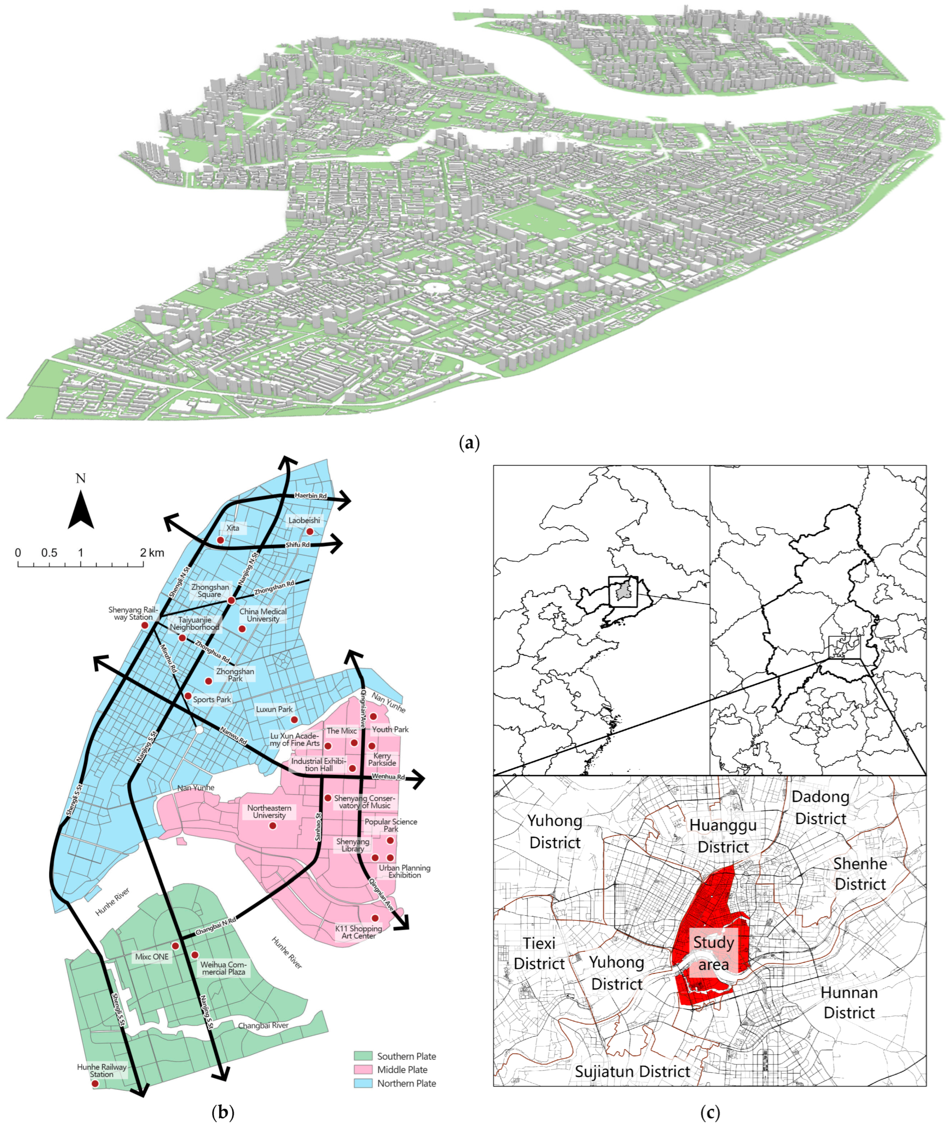
This study examined Heping District, Shenyang City, China, and classified urban morphology on a block scale in terms of building morphology and functional and cultural attributes of land. Based on the classification results, this study examined the organization patterns and characteristics of various types of urban morphology, identified urban morphology phenomena, and analyzed their evolution mechanisms. Our findings may be applied to urban renewal, planning management, and design governance, providing an understanding of fundamental rules.
The innovative nature of this research is expressed through several key points:
It integrates physical, functional, and cultural dimensions in urban morphology classification, providing a more comprehensive analysis than traditional approaches.
It combines supervised and unsupervised classification methods, allowing for a more nuanced categorization of urban forms.
It focuses on the block scale, offering insights into fine-grained spatial patterns that can inform targeted urban planning strategies.
It introduces a quantitative approach to incorporating cultural attributes in urban morphology analysis, addressing a significant gap in the existing literature.
3. Results
3.1. Building Morphology
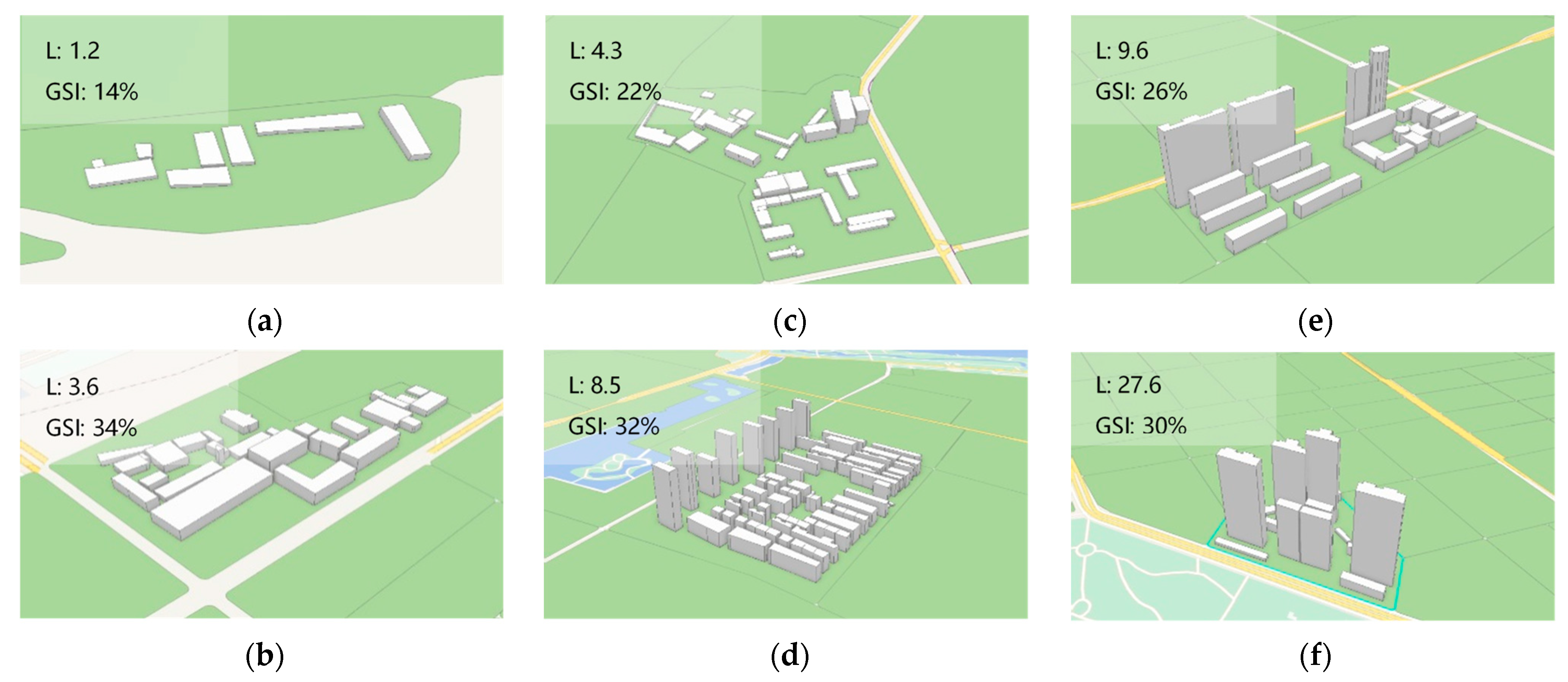
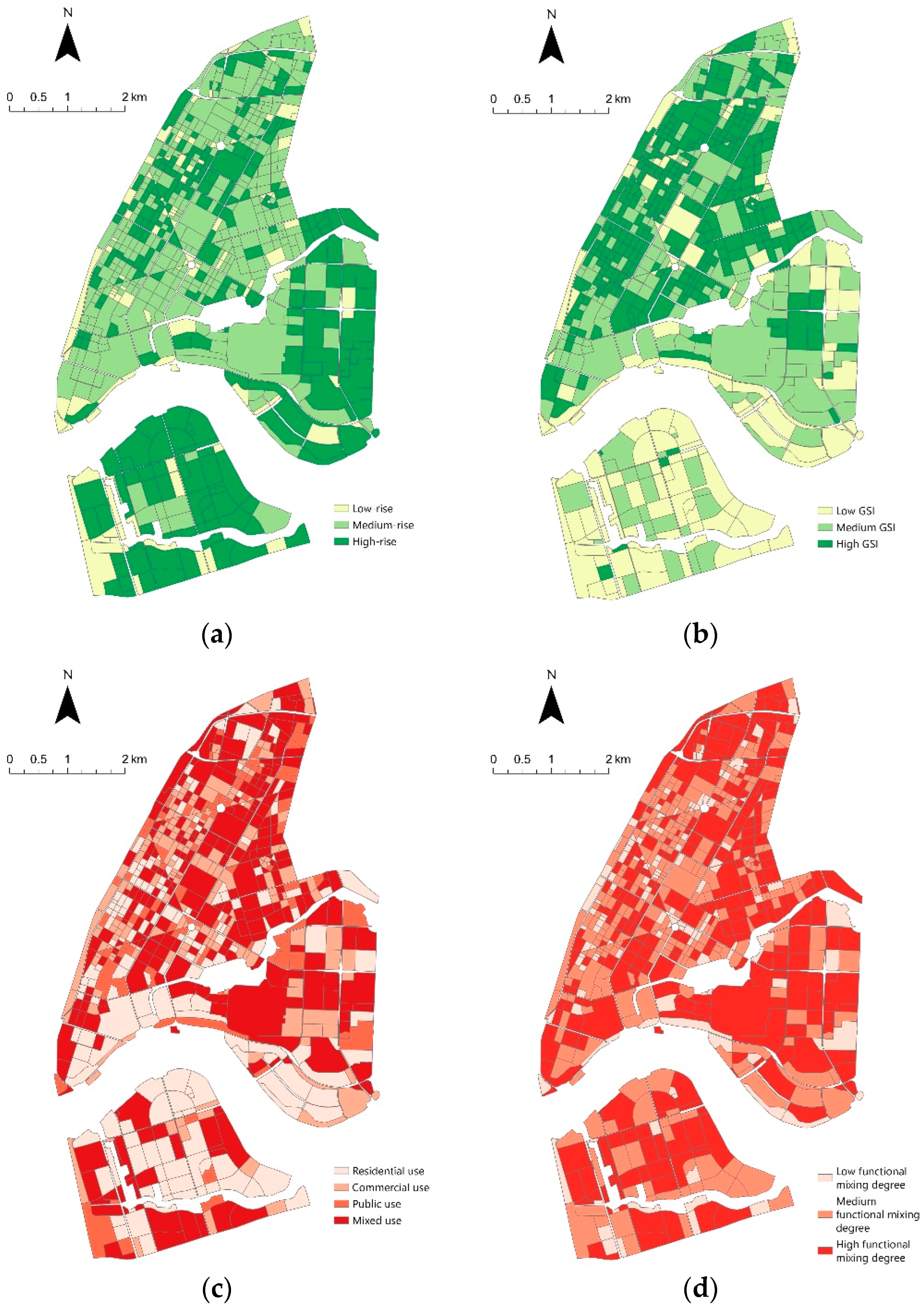
Figure 3a illustrates the distribution of building morphology in the study area. Low-rise and multi-story blocks accounted for 14.9% of the total, multi-story and high-rise blocks for 49.0%, and high-rise and super high-rise blocks for 36.0%. High-rise and super high-rise blocks were mainly distributed in the southern and middle study area and around the Shenyang Railway Station, contributing to a more modern urban appearance compared to other regions. High-rise buildings in the northern study area were concentrated mainly in commercial and business areas. Diverse urban functions, including commerce and residence, were identified in the middle and southern study areas. Low-rise and multi-story blocks were relatively rare and did not display any discernible pattern.
Figure 3b depicts the spatial distribution of the ground space index (GSI). High-GSI blocks were predominant, accounting for 52.2% of the total. They were distributed in old urban areas and areas with dense commercial and business facilities, in which buildings were universally low and dense, with large-sized skirt buildings. Medium- and low-GSI blocks accounted for 27.5% and 20.3%, respectively. The GSI of blocks exhibited clear construction age characteristics. In the relatively old northern study area, the block size was small, and the GSI was high. In the relatively new middle and southern study areas, the block size was large, and the GSI was low. Particularly in the southern study area, the GSI was universally low, and the green space ratio was high in newly constructed residential areas.
3.2. Block Functions
Figure 3c illustrates the spatial distribution of block functions. Mixed-use blocks were predominant (35.5%), indicating the pursuit of high efficiency and diversity in urban space utilization. We identified 207 commercial-use blocks, which were concentrated mainly in core commercial areas or distributed along the arterial traffic routes. We identified 168 residential-use blocks. Several large residential areas were distributed in the southern study area and along the Hunhe River. Residential-use blocks in the northern study area, which were relatively small-sized and densely distributed, were concentrated mainly in the periphery of commercial core areas. Moreover, we identified 91 public-use blocks, which were scattered throughout the study area and provided necessary public services and places for citizens.
Figure 3d shows the spatial distribution of the functional mixing degree across blocks. The study area was significantly characterized by the predomination of blocks with a medium or high functional mixing degree. The blocks with a low functional mixing degree (accounting for 21%) included mainly large retail centers, single-function administrative and corporate organizations, public service facilities, and green open space.
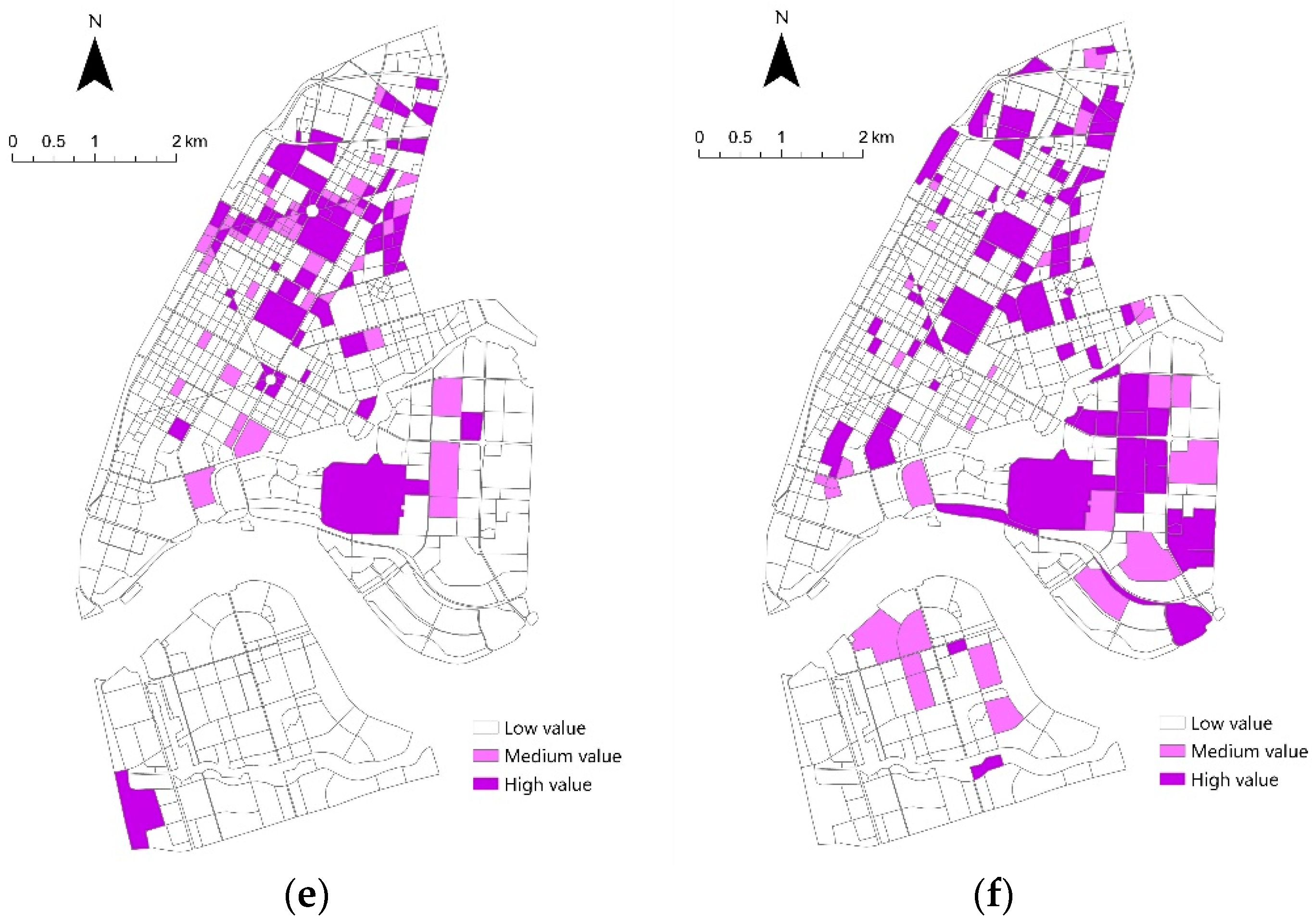
3.3. Cultural Value
Figure 3e depicts the spatial distribution of historical cultural resources. Blocks containing such resources were relatively scarce (17.4%), and they were primarily concentrated in the southern part of the northern study area and in the middle study area. High-value historical cultural blocks slightly outnumbered medium-value historical ones. High-value historical cultural blocks in the northern study area were clustered mainly in the Zhongshan Road historical cultural block and were centered on Zhongshan Square. Medium-value historical cultural blocks were scattered and embedded in high-value historical cultural blocks, reflecting the aggregation of historical cultural elements in specific historical stages. These high-value and medium-value historical cultural blocks jointly constituted a historical cultural network. High-value and medium-value historical cultural blocks in the middle study area were mostly clustered in the Zhongshan Road historical cultural block and contained several schools with historical value. Low-value historical cultural blocks contained several schools and exhibition halls with historical value. These blocks jointly constituted a historical cultural network, reflecting the aggregation of historical cultural elements. The southern study area that evolved from villages and farmlands was a newly developed area, with only one provincial-level historical cultural relic protection site (i.e., Hunhe Railway Station) and no historical cultural resources in other blocks.
Figure 3f presents the classification results for modern cultural resources. Similar to the distribution of historical cultural resources, blocks with modern cultural resources were scarce (15.1%), but they were evenly distributed in the centers of all urban districts. High-value modern cultural blocks were distributed mainly in the northern and middle study areas, especially in areas where colleges and city-level public cultural facilities were clustered. The distribution of modern cultural resources shows that many medium-value modern cultural blocks are located in proximity to high-value modern cultural blocks, exhibiting a trend of outward diffusion. This suggests that high-value modern cultural blocks can exert a driving effect on surrounding blocks, facilitating the dissemination and development of modern culture.
3.4. Urban Morphology
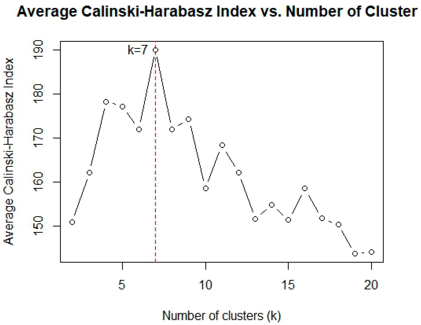
Urban morphology was classified using the k-means clustering algorithm. The optimal number of clusters was determined using the Calinski–Harabasz (CH) index to ensure result accuracy. Higher CH index values indicated more compact and scattered clusters and better clustering results. To stabilize the clustering results, the average CH index value was determined by averaging the multiple calculated CH index values (
Figure 4). The CH index reached the maximum value, indicating the optimal clustering result, at k = 7. Therefore, the number of clusters was set to seven.
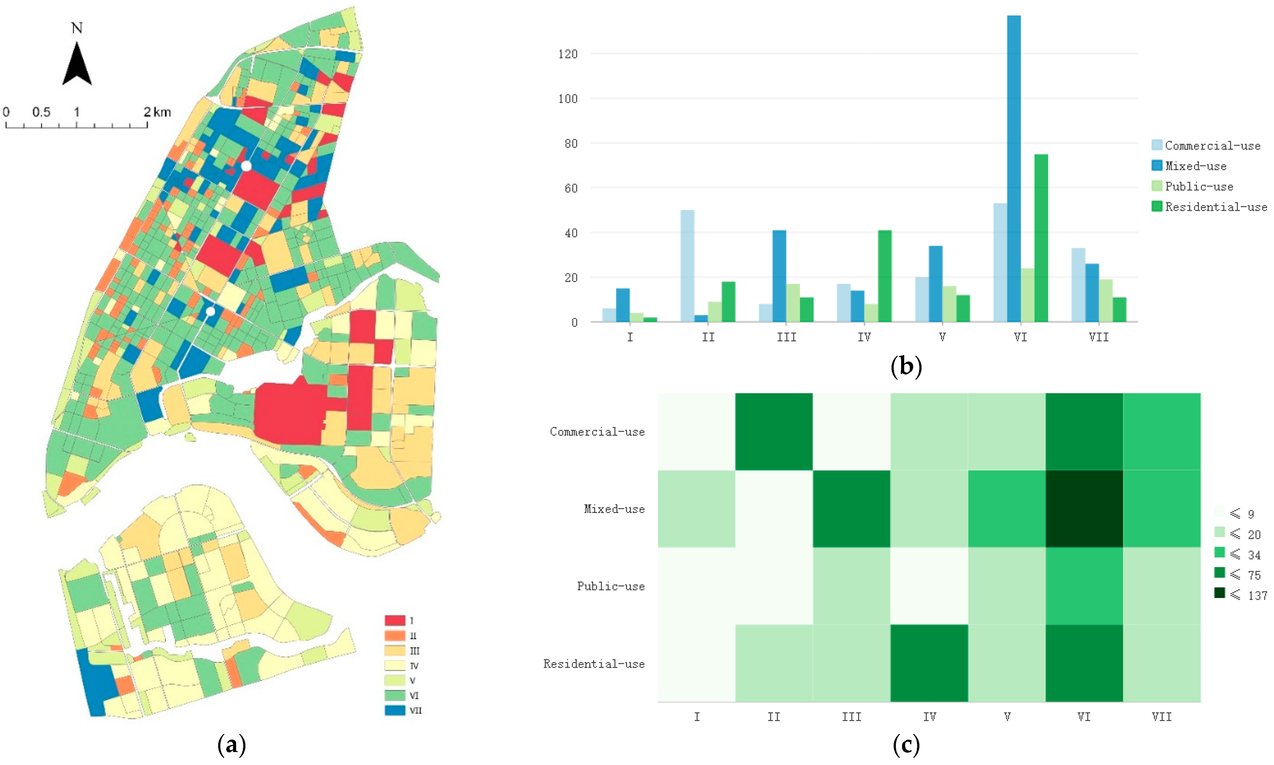
As shown in
Table 5 and
Figure 5, the blocks in the study area were classified into seven categories.
Figure 6a presents the classification results for the urban morphology of blocks in the study area.
Category I blocks were large, and they significantly affected the characteristics of urban morphology. These blocks were distributed mostly in areas with a mixture of historical sites and modern construction; therefore, they exhibited some modern construction characteristics while retaining historical characteristics.
Category II blocks were scarce. These blocks were characterized predominantly by low-rise buildings, a high GSI, a low functional mixing degree, and insignificant cultural value. These blocks were distributed primarily in old urban communities.
Category III blocks in the middle and southern study areas were characterized by high-rise buildings, a high GSI, and a high functional mixing degree. They dominated the cluster morphology in the middle study area. These blocks could be considered typical urban morphology in modern construction.
Category IV blocks were distributed mainly in the residential construction land in the middle and southern study area and constituted the dominant residential morphology in modern cities.
Category V blocks were characterized predominantly by low-rise buildings, a low GSI, a medium functional mixing degree, and low cultural value. These blocks mostly manifested as parks or squares. They were an important part of the urban landscape that could alleviate the spatial pressure exerted by high-density urban construction and improve urban image and attractiveness.
Category VI blocks were widely distributed in the northern study area, and the blocks were characterized mainly by a high development intensity and high functional mixing degree. This is a common result of urban renewal, where low-rise buildings in old urban areas are updated and transformed into high-intensity high-rise buildings. The design of these blocks used principles that emphasized mixed-use development, high-density construction, and the strategic integration of public spaces, demonstrating that they aimed to achieve efficient urban functions through comprehensive urban development.
Category VII blocks were characterized predominantly by medium-rise buildings, a medium–high GSI, a medium functional mixing degree, and insignificant modern cultural value. These blocks were distributed mainly in old historical areas, with numerous preserved historical buildings and cultural features and few modern buildings.
Figure 6b presents the ratios of urban morphology and land-use classifications. Category VI blocks were the most predominant and had mainly residential and public functions, with few commercial and mixed functions. Commercial-use blocks were dominant in Category II and had mainly commercial functions. Likewise, Category IV blocks had mainly residential functions. Mixed-use blocks accounted for the majority of blocks in Categories I and III. Urban functions were distributed evenly among blocks in Categories V and VII.
Figure 6c presents the quantitative distribution of blocks with various functions. Mixed-use blocks, which were the most numerous, comprised diverse morphology types. Category II blocks were scarce; conversely, other categories, particularly Category VI, had many blocks, suggesting their intensive and efficient use of various functional facilities.
Among residential-use blocks, those in Categories IV and VI were dominant. They were characterized by a medium development intensity and medium–high functional mixing degree. This ensured residential quality and provided residents with convenient services. These blocks typically possessed relatively well-developed infrastructure and public service facilities, such as schools, hospitals, parks, and shopping centers, enabling residents to enjoy convenient living services. Meanwhile, the medium development intensity ensured that the blocks had sufficient residential space without congestion, providing residents with a comfortable living environment. Furthermore, the medium to high functional mixing degree meant that these blocks both met residential needs and integrated commercial, office, cultural, and entertainment functions, fostering community vitality and diversity. This layout helped reduce residents’ daily commuting distances, improve living efficiency, and enhance community cohesion and a sense of belonging.
Among commercial-use blocks, those in Categories II and VI were dominant, followed by those in Category VII. Among commercial-use blocks, those without cultural elements contained concentrated low-rise, high-density, and low-end commercial buildings and complexes. The blocks with historical cultural elements were characterized by a high development intensity, particularly in the Zhongshan Road historical cultural block. This suggested that the protection and preservation of historical cultural heritage were not given sufficient attention in the process of urban development and construction.
Public-use blocks comprised mainly those in Category VI, followed by those in Categories III, V, and VII. These blocks were characterized by a high functional mixing degree. Among public-use blocks, those with high cultural value, including those with public facilities such as elementary and middle schools, exhibited high development intensity. General blocks, including urban parks and green space, exhibited low development intensity.
4. Discussion
Our analysis revealed seven distinct urban morphology types in Heping District, each with unique spatial configurations and evolutionary tendencies. The dominance of the Category VI morphology, characterized by a high development intensity and a high functional mixing degree, reflects trends towards efficient land use and multifunctional urban spaces in modern urban development. This trend is likely driven by increasing land values in central urban areas and the need to accommodate diverse urban functions within a limited space.
Our findings both support and extend previous research on urban morphology. For instance, our observation of high-density, high-rise clusters in central areas aligns with Longley’s and Batty (1997) [
38] findings on urban density gradients. However, our study goes beyond physical characteristics by incorporating functional and cultural attributes, providing a more comprehensive understanding of urban spatial patterns.
Unlike studies that focus solely on building morphology (e.g., Ye et al. [
23]), our study integrates functional mixing degree and cultural value, revealing complex interactions between these dimensions. For example, we found that areas with high cultural value often exhibit unique morphological characteristics, a finding not typically captured in traditional morphological studies. Key findings include the following:
A high density and vertical growth of buildings as a typical outcome of modern urban densification.
A strong correlation between land-use functions and rent-paying capacity.
A trend towards comprehensive and diverse urban functions in urban planning, as evidenced by the large number of street blocks with a medium to high mixing degree.
The intermingling of historical and modern cultural landscapes, forming the dominant cultural spatial morphology in the study area.
Regular spatial distribution patterns of the seven urban morphology types, including cluster morphology, morphology with distinct spatial units, and substrate morphology.
Our methodology also differs from previous approaches. While studies like that of Long [
30] used supervised deep learning for morphology classification, we combined supervised and unsupervised methods, allowing for more nuanced categorization. This approach enabled us to identify seven distinct morphology types, offering a more detailed classification than many existing studies.
The results revealed that urban morphology types in the study area exhibited a regular distribution pattern. The high density and vertical growth of buildings were a typical outcome of modern urban densification. Urban morphology types were highly diverse and complex. These findings indicated that, as noted by Mouratidis [
50], when common urban problems are addressed, and when urban planning integrates all essential characteristics, a compact city has a positive influence on livability. Previous studies primarily used the physical morphology and functional attributes of buildings and street blocks for morphological research. This study incorporates the dimension of cultural attributes, expanding the classification criteria for urban morphology and allowing the spatial distribution of urban morphological types to be interpreted from multiple different perspectives. This aligns with previous research in which high-rise buildings often serve as iconic structures in urban centers, reflecting the commercial vitality and modernization level of a city.
From an urban development perspective, cities are evolving towards increased concentration, compactness, and higher density, aiming to minimize land consumption and optimize resource and energy efficiency [
36]. For historical reasons and due to space constraints, old cities often show a dense distribution of mid-level buildings. This occurs because the architectural form of old cities retains their historical characteristics to a certain extent during urban expansion and modernization [
51].
Low-rise buildings are frequently correlated with green spaces and open areas, which are associated with an improved quality of life and enhanced environmental conditions. Forman [
52], therefore, suggested that protecting green spaces and historic buildings was important in urban planning.
The observed density distribution aligns with the findings of Longley and Batty [
38], who proposed that the differentiation of functional areas within a city and the spatial arrangement of varying density zones significantly influence overall urban functionality.
The findings of this study corroborate previous urban morphological research and provide additional empirical evidence supporting established patterns of building height and density distribution within urban areas. This study not only enriches the existing theoretical framework but also provides empirical evidence for urban planning and management, contributing to the optimization of urban spatial layouts and an improvement in urban living quality. From the perspective of urban development, Zhang and Tang [
36] argue that cities are evolving or tend to evolve in the direction of concentration, compactness, and high density, aiming to occupy less land and conserve resources and energies. High-rise blocks were concentrated in core business areas but scattered in urban residential areas; medium-rise blocks were concentrated in old urban areas, and owing to historical reasons and space constraints, the old city often shows the dense distribution of mid-level buildings. This phenomenon can be explained by the fact that, as noted by Rodger and Whitehand, during urban expansion and modernization, the architectural form of the old city retains its historical characteristics to a certain extent, and a small number of low-rise buildings are scattered in green areas and historic buildings. Thus, multi-story and high-rise blocks were relatively concentrated and dominant, occupying most of the study area. This pattern has been referred to as substrate urban morphology; conversely, high-rise and super high-rise blocks are the main manifestations of modern urban morphology and are referred to as cluster urban morphology [
53]. High-density blocks were concentrated in old urban areas and core business and commercial areas; medium-density blocks were distributed near a river system and its surrounding areas, and low-density blocks were distributed in urban fringes and areas with wide open space. Low-rise buildings are often associated with green spaces and open spaces, which contribute to a higher quality of life and a better environment. This highlights the importance of protecting green spaces and historic buildings in urban planning, as emphasized by Forman [
52].
Land-use functions were strongly correlated with rent-paying capacity. A large number of street blocks with a medium to high mixing degree suggested a trend towards comprehensive and diverse urban functions in urban planning. The greater functional mixing degree in the old northern urban areas was closely related to the scarcity of land resources; hence, the street-side commercial function may have been activated to relieve the scarcity of land resources and promote economic diversity. A similar strategy may have been implemented in the newly built residential areas along the Hunhe River and in the southern study area; in particular, commercial facilities were integrated to meet the needs of residents and promote community self-improvement. Mixed-use blocks (the main blocks in Category VI), which are used to meet the daily living needs of residents by alleviating urban land shortages, were evenly distributed. Commercial-use blocks were evenly distributed along major roads and traffic nodes. Residential-use blocks were mainly distributed in the southern study area and along the Hunhe River, and they were concentrated in the periphery of commercial areas in the northern study area. Public-use blocks were scattered along major roads and were connected to constitute a public service network. Many blocks had medium or high functional mixing degrees, suggesting a trend towards comprehensive and diverse land use in urban space planning. In the era of sustainable development, now that land mixed use has been listed as a national planning policy by various countries, its essential goal is to integrate various sustainable elements for functional mixed development and form high-quality urban space [
54]. To better achieve the multi-dimensional sustainable effect goal of continuous enrichment and upgrading, people constantly promote optimizing the land mixed-use system’s structure through multiple security methods. This is based on functional mixing, and it achieves better land mixed use [
55]. However, our results show that there are more streets with a medium and high degree of mixing, which follows the trend of mixed land use, as shown in this study. Of course, we found some mono-functional street blocks. From the perspective of urban planning, these single-function blocks highlight the necessity and unique value of specific functional partitions and play a non-negligible role in maintaining professional service supplies and the urban ecological balance of the city.
No intact historical cultural landscape areas were identified. Historical and modern cultural landscapes were intermingled, constituting the dominant cultural spatial morphology in the study area. High-value historical cultural blocks were concentrated in core urban areas, forming the main aggregation areas of historical culture. Medium-value historical cultural blocks were scattered within high-value historical cultural blocks, further enriching the overall historical cultural landscape. In addition to the more important historical cultural resources, there were also some ordinary historical cultural resources, and the transition from high to low was relatively smooth. Modern cultural blocks were evenly distributed, and they comprised high-level blocks with a wide sphere of influence. This indicated a high construction level of modern cultural facilities in Shenyang and a driving effect of high-level public cultural facilities on the surrounding cultural resources.
The spatial distribution of the seven types of urban morphology exhibited some regularities. We identified a cluster morphology with an aggregation of high-rise buildings (Category III), a morphology with distinct spatial units (Category I), and a substrate morphology as the urban background (Category VI). The urban subcenter area in front of Shenyang Railway Station contained a combination of diverse urban morphology types, hindering the identification of the cluster advantages of a specific morphology. This differed significantly from the classification results of a single building morphology type.
Category VI was the dominant substrate morphology, and it was characterized by high development intensity and a high functional mixing degree. This is consistent with the findings of Batty and Marshall, who pointed out that areas with high-intensity development and a high functional mix in modern cities tend to be concentrated in the urban cores and important functional areas. This indicates that, in the development of modern cities, regions with a high functional mix can better adapt to complex and changeable social and economic needs, enhancing the overall vitality and adaptability of a city [
56]. The Category I morphology was the rarest, and it was characterized by a high development intensity, a high functional mixing degree, and high cultural value. The Category I blocks contained mainly colleges and historical cultural landscape areas with both historical cultural elements and modern functions. This aligns with the findings of Kostof [
57], who emphasized that historical and cultural areas in cities are not only carriers of cultural heritage but also important components of modern urban functions. The preservation and development of such areas are of great importance for maintaining a city’s historical continuity and cultural diversity [
57]. However, under the wave of rapid urbanization, these areas are also facing unprecedented development pressure. The rise of tall buildings and the dense layout of commercial facilities have promoted economic prosperity to a certain extent, but they have inevitably caused obstruction and intrusion into historical buildings and destroyed original historical styles and spatial patterns. In urban planning, it is necessary to reflect deeply and take effective measures to ensure that historical and cultural heritage is respected and protected in the new era of urban development.
Category III morphology was characterized by high-rise buildings, a high GSI, and a high functional mixing degree, and it was the dominant cluster morphology in the middle and southern study areas. This type of morphology could be considered typical in modern urban construction. For example, in the central plate, Category III accounted for 27.8% of the total block area. When only the street blocks along the main road are considered, this pattern occupies 64% of the total area of the street blocks along the road. This pattern is also commonly seen along major roads in the southern plate. Vertical growth, efficient land use, and mixed development are key strategies to cope with rapid population growth and economic activity. Therefore, it can be considered a typical form type of contemporary urban development.
Mixed-use blocks were the most numerous, predominantly in Category VI, suggesting a trend towards high functional mixing in urban development. Residential-use blocks were mainly in Categories IV and VI, characterized by a medium development intensity and a medium–high functional mixing degree. Commercial-use blocks were predominantly in Categories II and VI, while public-use blocks were distributed across Categories VI, III, V, and VII.
Furthermore, the results highlighted transitions and integrations across various morphology types, indicating that urban morphology has undergone a complex evolutionary process influenced by historical factors. In the study area, the most obvious transition area was the northern plate, where the traditional low-rise residential areas gradually penetrated into the commercial facilities, forming a mixed residential and commercial area. This mix not only improves the efficiency of land use but also provides more convenient living conditions for urban residents.
To validate our findings and test the applicability of our methodology beyond Shenyang City, we conducted a comparative analysis with similar studies in other urban contexts.
In Porto, Portugal, Oliveira et al. [
58] utilized a multi-dimensional approach to classify urban forms; they considered the building typology, street layout, and plot structure. While their methodology was similar to ours, they did not explicitly include cultural attributes in their analysis. Our inclusion of cultural factors provides a more comprehensive understanding of urban morphology, particularly in cities with rich historical backgrounds like Shenyang.
Another relevant study was by Ye et al. [
23], who introduced the concept of “Form Syntax” as a morphological tool for urban design. Their approach combines space syntax with urban form analysis, focusing on the relationship between street-network configuration and building morphology. While our study shared the goal of quantifying urban forms, we extended our research beyond physical attributes to include functional and cultural dimensions. This multi-dimensional approach allows us to capture a more holistic picture of urban morphology. Ye et al.’s [
23] method excels in analyzing the intricate relationships between street networks and building forms, which could complement our approach. Their focus on “urbanity-making” aligns with our findings on the importance of functional mixing and cultural attributes in shaping urban spaces. However, our method provides a more comprehensive classification system that explicitly considers cultural and functional aspects, which are crucial for understanding the complex urban fabric of Chinese cities.
Our methodology has both similarities and differences compared to these other studies. The general trend of identifying high-density, mixed-use areas in city centers is consistent across all studies. However, our identification of specific morphology types influenced by cultural attributes (e.g., Category I with a high cultural value) is unique to our approach.
These comparisons highlight the adaptability of our method to different urban contexts while also emphasizing the importance of considering local factors, particularly cultural attributes, in urban morphology classification. The integration of physical, functional, and cultural dimensions in our study provides a more nuanced understanding of urban forms, especially in cities with rich historical contexts. Future research could further test our methodology in other Chinese cities or international contexts to enhance its generalizability, potentially incorporating elements from “Form Syntax” to strengthen the analysis of street-building relationships.
5. Conclusions
This study demonstrates that urban blocks with diverse spatial morphologies exhibit distinct numerical characteristics across multiple dimensions. These characteristics can be effectively identified and interpreted using a multidimensional numerical analysis approach. The findings of this study offer significant academic and practical implications across multiple domains: (1) they provide a scientific foundation for urban planning and management; (2) they inform practices in urban development and renewal; (3) they offer strategic support for the conservation and utilization of historical cultural resources; and (4) they introduce methodological innovations for public space and service facility planning.
This study contributes to the theoretical framework of urban morphology and offers valuable insights for related fields of study. However, acknowledging the limitations of this study is crucial. The accuracy of the identification and classification results may have been affected by potential errors, omissions, or outdated information in the available construction and POI data. Future studies should consider incorporating manual verification to mitigate these potential inaccuracies. To address these limitations and further advance this line of research, we propose the following directions for future studies: (1) Expand the study area to include a wider range of cities and districts, thereby increasing the sample size to test the applicability of the multidimensional numerical analysis method across diverse urban morphologies. (2) Further refine and expand the multidimensional attributes, incorporating additional socioeconomic and cultural factors, to provide a more comprehensive analysis of their influence on urban morphological evolution. (3) Introduce a temporal dimension to investigate the evolutionary patterns of urban morphology across different historical periods, focusing on the dynamics and mechanisms of change.
This study contributes to the field of urban morphology in several ways. First, it introduces a novel multidimensional approach that integrates physical, functional, and cultural attributes, addressing a significant gap in the existing literature, which often focuses solely on physical characteristics. Second, our methodology combines supervised and unsupervised classification methods, offering a more nuanced and comprehensive categorization of urban morphology. Third, by focusing on the block scale, our study provides insights into the fine-grained spatial patterns of urban forms, which can inform more targeted urban planning and management strategies.
While this study focused on Heping District, Shenyang City, the methodology developed here can be applied to other urban areas. Future research should test the replicability of this approach in different geographical and cultural contexts to validate its broader applicability.
The findings of this study have important implications for urban planning and design. By identifying distinct morphology types and their spatial distribution, our research can guide more tailored approaches to urban development, conservation, and renewal. Furthermore, our methodology can be adapted and applied to other urban contexts, potentially leading to comparative studies that could enhance our understanding of urban morphology across different cities and cultures.


