Article

A Study on the Spatiotemporal Aggregation and Corridor Distribution Characteristics of Cultural Heritage: The Case of Fuzhou, China

1
School of Architecture, Huaqiao University, Jimei District, Xiamen 361021, China
2
Urban and Rural Architectural Heritage Protection Technology Key Laboratory of Fujian Province, Jimei District, Xiamen 361021, China
3
School of Architecture, Tianjin University, Tianjin 300072, China
*
Author to whom correspondence should be addressed.
Buildings 2024, 14(1), 121; https://doi.org/10.3390/buildings14010121
Submission received: 31 October 2023 / Revised: 14 December 2023 / Accepted: 19 December 2023 / Published: 2 January 2024
(This article belongs to the Special Issue Advanced Research on Cultural Heritage)

Abstract

:
Fuzhou is an important city on the southeast coast of China with rich cultural heritage resources, and it is a national historical and cultural city in China. The main purposes of this study are the following: 1. To study the current situation and spatial distribution of cultural heritage; 2. To study the construction of cultural heritage corridors; 3. To utilize the holistic characteristics of heritage corridors to integrate the cultural heritage elements along the corridors and achieve the optimal allocation of resources. This study collects data from 605 cultural heritage sites in Fuzhou City and establishes a GIS database. The spatial distribution characteristics of cultural heritage in Fuzhou City are studied using aggregation analysis, nearest neighbor analysis, and buffer analysis in GIS technology. The following results were obtained: there is a cultural heritage corridor in Fuzhou City with the Minjiang River serving as the main land and water transportation line, and the closer one is to the water transportation line, the more intensive the distribution of cultural heritage points; and there are three cultural heritage node areas and one special cultural heritage node area. The study of Fuzhou’s heritage corridor system has important reference significance for the protection of cultural heritage in coastal historical cities in China and even in East Asia and has exploratory value for the holistic protection of cultural heritage and for the planning and development of tourism.

1. Introduction

Cultural heritage is a direct reflection of the material and spiritual life of various social classes at that time, with extremely rich cultural connotations and precious academic value. With time, the amount of cultural heritage in cities is increasing, and the spatial and temporal distribution range is gradually expanding, making their protection and management situation more severe. This study establishes a cultural heritage database in Fuzhou City, abandons empirical research methods, and innovatively analyzes its spatial clustering characteristics. It proposes a forward-looking discussion on the overall protection system of cultural heritage in Fuzhou City, which not only benefits the public’s understanding of cultural heritage protection but also facilitates the development of cultural heritage protection and management in China and even East Asia.
Fuzhou is located in the eastern part of Fujian Province, downstream of the Min River, and is an important city on the southeast coast of China, one of the first five ports of commerce opened in modern China. As a city with a history of 2200 years, Fuzhou was announced as the second batch of national historical and cultural cities by the State Council in 1986.
In 2013 and 2021, laws and regulations such as the “Fuzhou Historical and Cultural City Protection Regulations”, “Fuzhou Historical and Cultural City Protection Plan”, and “Fuzhou San Fang Qi Xiang Protection Plan” were successively introduced [1]. Major projects involving the historical and cultural landscape area of Yantai Mountain and the protection of the three lanes and seven alleys have been launched, but these practices have only protected very few areas in Fuzhou City, neglecting the overall connection value of time, geography, culture, and other aspects within the entire urban spatial scope. How to improve the overall research and protection level of cultural heritage has become an issue that cannot be ignored in the urban management of Fuzhou City.
At present, there is very little research on Fuzhou’s cultural heritage, mainly including the construction of a theoretical framework for the management system of historical and cultural cities [2]; the overall protection of historical blocks or treating the protection [3] and development of historical and cultural heritage from a sustainable development perspective; and properly handling the relationship between cultural heritage protection and development [4]. Overall, research on Fuzhou’s cultural heritage focuses more on theoretical and small-scale block levels, with a serious lack of comprehensive observation and protection planning of cultural heritage within the city. This study aims to analyze the spatiotemporal aggregation and distribution characteristics of cultural heritage within the city of Fuzhou by introducing the concept of “heritage corridors” and aims to establish a comprehensive protection mechanism for cultural heritage in Fuzhou.
Since the 1960s, the concept of the greenway has matured, and with the development of heritage conservation towards regionalization [5], the concept of heritage area conservation has been introduced, which Flink CA refers to as “a linear landscape with a collection of special cultural resources”. The construction usually includes tourism development, architectural heritage conservation and reuse, and environmental management [6]. Heritage corridors, as a collection of greenways and heritage areas, are a new type of conservation approach (Figure 1). This conservation direction integrates several concepts such as heritage conservation, ecological recreation, and cultural presentation, emphasizing the preservation of various cultural landscapes at the regional level. Corridors are usually characterized by economic development, tourism, adaptive reuse of heritage, and recreational environment improvement [7].
A search of the Web of Science with the subject “heritage NEAR/5 corridor” yielded 132 results. The earliest record appeared in 1986 for a conference on conservation programs in the Black Rock River Valley [8]. Among the search results, 9.85% (13 articles) and 4.55% (6 articles) of the articles were related to architecture and urban studies, which were fewer in number (Figure 2 and Figure 3).
The research on heritage corridors internationally mainly includes two aspects: the evaluation system of heritage corridors and the protection mode of heritage corridors.
In the evaluation system of heritage corridors, Byrne, Holladay, and other researchers established a corridor evaluation system, which is expected to more accurately reflect the operation, development status, and input–output benefits of the corridor system and facilitate the formulation of reasonable conservation strategies [9]. Mar, L. et al. used GIS techniques to assess the feasibility of the corridor node setting [10]. Liang, Hong, and LaPoint analyzed and constructed heritage corridors at different spatial scales from the perspective of ecology [11]. Currently, functional corridors have been proposed in research results, such as the idea of developing smart eco-city corridors along the Manchester Ship Canal [12], green ecological corridors [13,14,15], cultural landscape corridors in villages [15,16], exploring the spatial structure of intangible cultural heritage and constructing corridors along the Ming Great Wall that facilitate the adaptive reuse of heritage, corridors constructed for the conservation of linear heritage [11,17,18], exploring whether there are cultural heritage corridors along the Tea Horse Road from multiple perspectives, and proposing a method of spatial integration to determine heritage corridors [19].
In the protection mode of heritage corridors, Severo used the concepts of cultural landscape and policy network theory to define the value of tangible and intangible cultural heritage in heritage corridors [20]. From the perspective of national linear cultural heritage conservation, Lin et al. used the concept of heritage corridors as a guide to explore the spatial structure of corridors using kernel density estimation and standard deviation ellipse analysis methods for intangible cultural heritage along the Ming Great Wall; the authors also further explored the spatial location of corridors in conjunction with a heritage corridor suitability analysis [11]. Feng et al. explored the development strategy of the cultural heritage corridor slow-moving facility system, which uses a low-disturbance structure based on the spatial distribution of heritage sites along the Great Wall and applies scientific methods such as the minimum cumulative resistance model to analyze the development suitability and ecological environmental conditions of the project site based on the assessment knot planning and design of the slow-moving facility system and node system [21].
Research on heritage corridors in China is relatively late compared with that in foreign countries. A total of 805 articles on “heritage corridors” were found in the Chinese academic journal network (Figure 4).
The domestic research on the construction of heritage corridors mainly originates from the spatial components of heritage corridors: heritage, green corridors, walking paths, and interpretation systems, which were proposed by scholars such as Wang Zhifang through the introduction of the American theory of the heritage corridor concept, conservation, and management system, and this is a more agreed-upon conclusion in academic circles today [7]. The research content is mainly focused on the study of the heritage corridor concept and heritage corridor conservation and utilization.
The concept of heritage corridors was first studied by Wang Zhifang (2001) in his article “Heritage Corridors as a New Approach to Heritage Conservation”, and he proposed the use of “heritage corridors” for heritage conservation. Li, Wei, and Yu, Kongjian (2005) introduced the development of cultural routes in China in “New Trends in World Cultural Heritage Conservation—Cultural Routes” and compared it with the heritage corridors that are already prevalent in the United States [22]. In 2007, Wang Fang (2007) studied the theory, practice, spatial characteristics, and development trend of linear space in “Progress and Development Trend of Linear Space Research” [23]. The study and practical exploration of heritage corridors can be found in [11]. In 2013, Liang Jie improved the theoretical and practical exploration of heritage corridors by interpreting and analyzing heritage corridors from the perspective of urban planning [24].
In terms of heritage corridor protection and utilization, scholars have applied the theory of the heritage corridor to the protection and tourism development of domestic cultural heritage in a multidimensional and holistic manner. A clear example is Zhu Qiang’s 2007 study on the construction of an industrial heritage corridor in the Jiangnan section of the Beijing–Hangzhou Grand Canal in which he compared the steps and characteristics of different countries or types of heritage corridors and summarized the basic idea of constructing a heritage corridor as follows: (1) heritage corridor theme identification and resource definition; (2) heritage value evaluation; (3) project planning and design; and (4) heritage management [25]. For example, the theoretical framework of the descriptive model–process model–evaluation model–change model–impact evaluation model is proposed in “Theoretical framework of heritage corridor and overall conservation of the Grand Canal” [26]. The theoretical framework for the construction of the decision model, etc., can be found in [26]. In 2008, Li Fei took the Silk Road as an example; analyzed the connotation, theoretical origin, value, and function of heritage corridors; and proposed a basic theory and model for the conservation and development of tourism resources of heritage corridors [27]. In 2009, Wang Xiaoyu took “Qing culture” as the theme, used four historical lines as the basis for the composition of heritage corridors, and introduced the theory of decision science to build a Beijing–Shenzhen cultural heritage corridor [28]. In 2014, Wang Yanyan analyzed the characteristics of the trinity of “time, space, and culture” of the Nanjing Ming City Wall, introduced the hierarchical analysis method to evaluate and define the corridor heritage resources, and proposed the conservation strategy of the Nanjing Ming City Wall heritage corridor [29].
In summary, there are rich research results on the spatial distribution of cultural heritage and heritage corridors worldwide. At present, there are many discussions reflected in the construction of heritage corridor systems, spatial structure analyses, and other aspects. China’s relevant research and theoretical exploration comprise a large proportion, and there is relatively little practical research. This study innovatively analyzes the spatial clustering and corridor distribution characteristics of cultural heritage at different periods through GIS technology and related tools.

2. Data Sources and Research Methods

Fujian is mountainous; the Min River, the first river in Fujian Province, is also the largest water system in Fujian Province. Other important rivers are Longjiang, Aojiang (also known as Aojiang, Daijiang), Sanxi (also known as the North and South Creeks), Start Creek, Dazhang Creek, Meixi, etc. (hereinafter referred to as the main waterway traffic routes) (Figure 5).
Fuzhou is an ancient city with a history of 1000 years, and according to available documents, Fuzhou has existed for more than 2200 years. Since the Han Dynasty, the city was first built as a Yecheng, then the Jin Dynasty expanded the Zicheng, and the Tang Dynasty expanded the Luocheng. Since the Tang Dynasty, Fuzhou’s ancient city has been mainly used as a place for government offices and officials to live, with the central axis of the city (today’s Bayiqi Road) on both sides being used for government offices. The northeastern part of the city was the Guangjie command camp, the northwestern part was the schoolyard and military quarters, and the southeastern part was the Kaiyuan Temple [30].
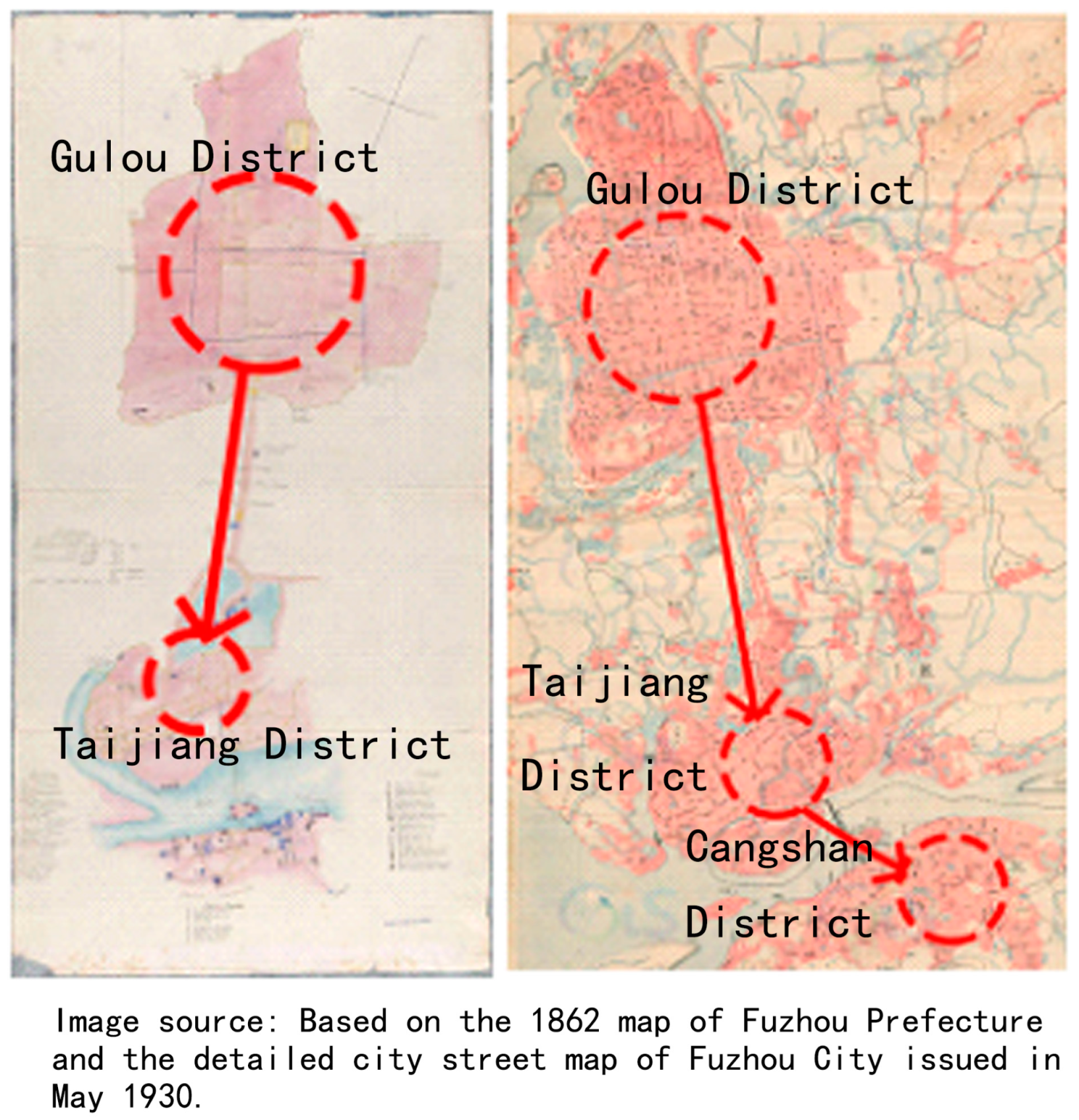
From the establishment of Hanye City to the outer city of the Song Dynasty, the urban space of Fuzhou has been expanding and changing from north to south, extending from the central axis to the east and west directions. In the Ming and Qing dynasties, the development of the commercial economy accelerated urban construction, which in turn promoted another change in the urban form of Fuzhou in the Ming and Qing dynasties, showing a double-group jumping pattern of common development from north to south (Figure 6) [31].

2.1. Data Sources

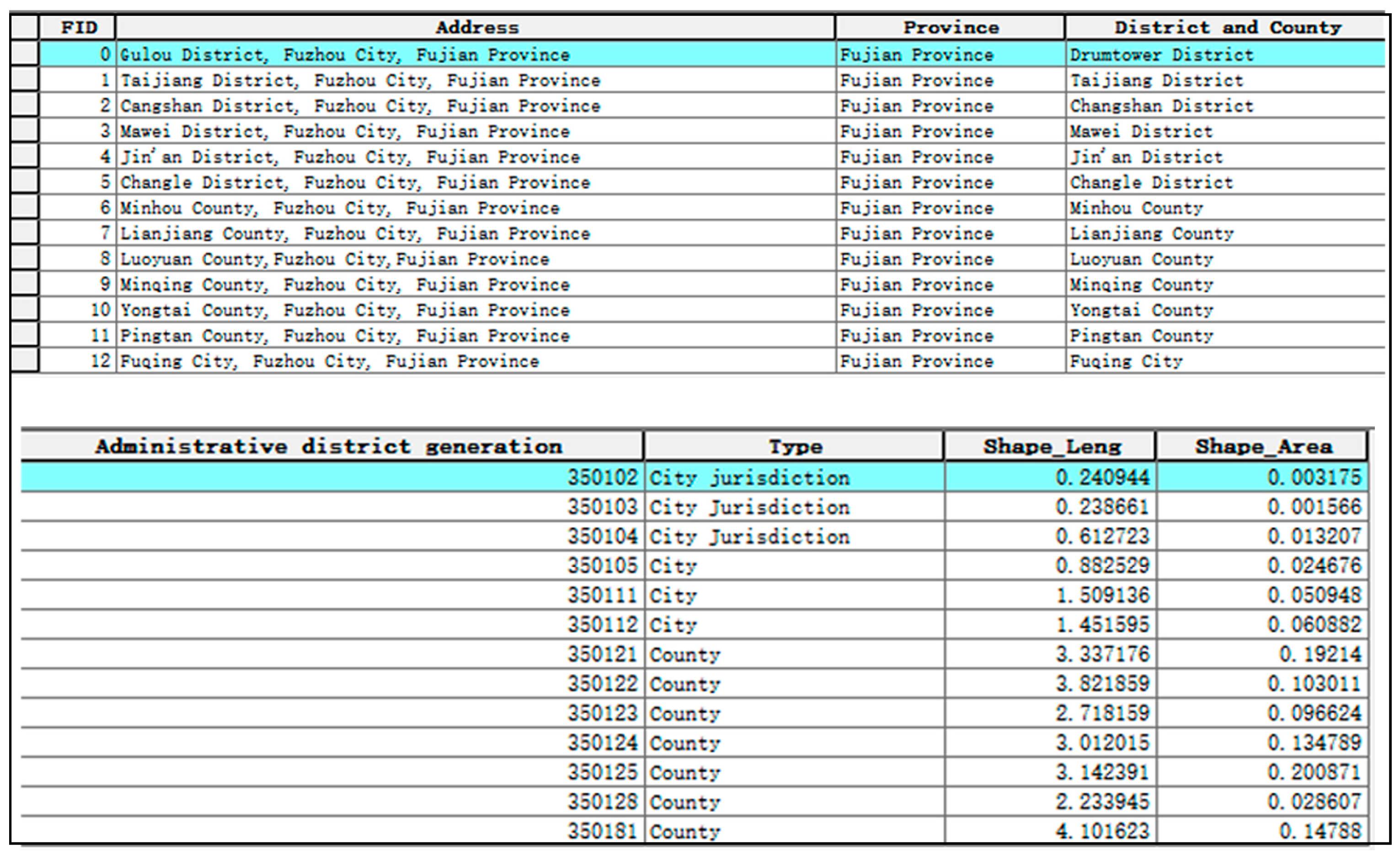
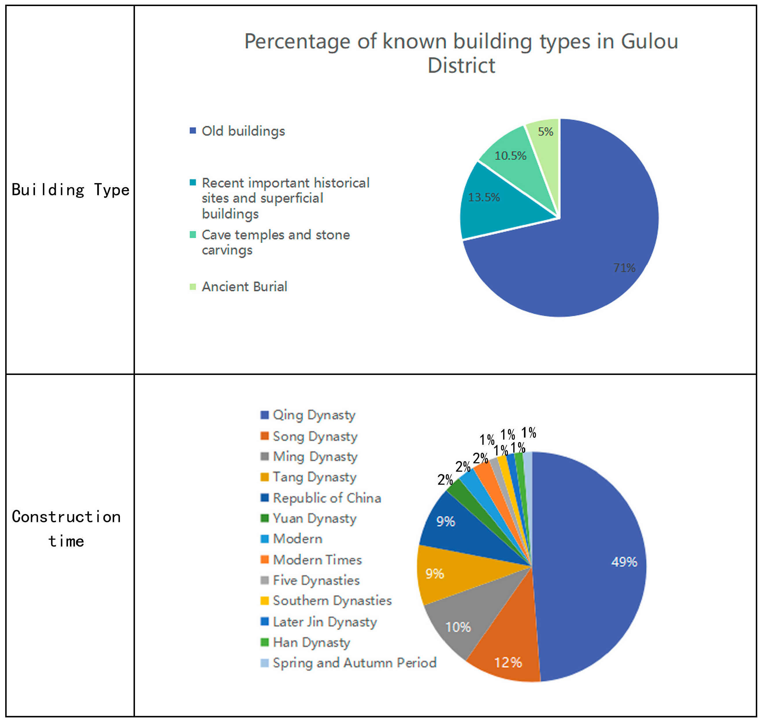
The research object of this paper is the cultural heritage within the municipal area of Fuzhou, including 29 national cultural heritage protection units, 128 provincial cultural heritage protection units, 120 municipal cultural heritage protection units, 309 historical buildings, 15 traditional villages, and 4 historical neighborhoods, totaling 605 items. These cultural heritages are characterized by large periods and diverse forms, but there is a lack of holistic conservation research and planning of heritage corridors. Therefore, this paper starts from the spatial distribution characteristics of cultural heritages in Fuzhou, hoping to show the direction for the subsequent cultural heritage conservation planning in Fuzhou City.
The data in this study can be divided into two categories: cultural heritage data and vector map information. The cultural heritage data are subdivided into Fuzhou national cultural heritage protection units (national protection), Fuzhou provincial cultural heritage protection units (provincial protection), Fuzhou municipal cultural heritage protection units (municipal protection), Fuzhou historical buildings (historical buildings), Fuzhou traditional villages (traditional villages), and Fuzhou historical and cultural districts (historical districts). The information on its Chinese preservation and traditional villages is from the website of the Central People’s Government of the People’s Republic of China, and the rest of the information is from the websites of the People’s Government of Fujian Province and Fuzhou City. The vector map information includes the Fuzhou city boundary, Fuzhou city limits, and Fuzhou city boundaries in the Republic of China, Song, Liang, Tang, Jin, and Han periods, all self-drawn according to the Historical Atlas of Fujian Province and Zheng Lipeng’s Study on the History of Urban Development in Fuzhou (see Table 1 for details).

2.2. Data Handling

The longitude and latitude coordinates of 605 cultural heritage sites were found on Google Earth. Information about each cultural heritage site was collected, including the corresponding dynasties, building types, addresses, and types of protection levels, and listed in a table for linking information (Table 2 and Table 3).
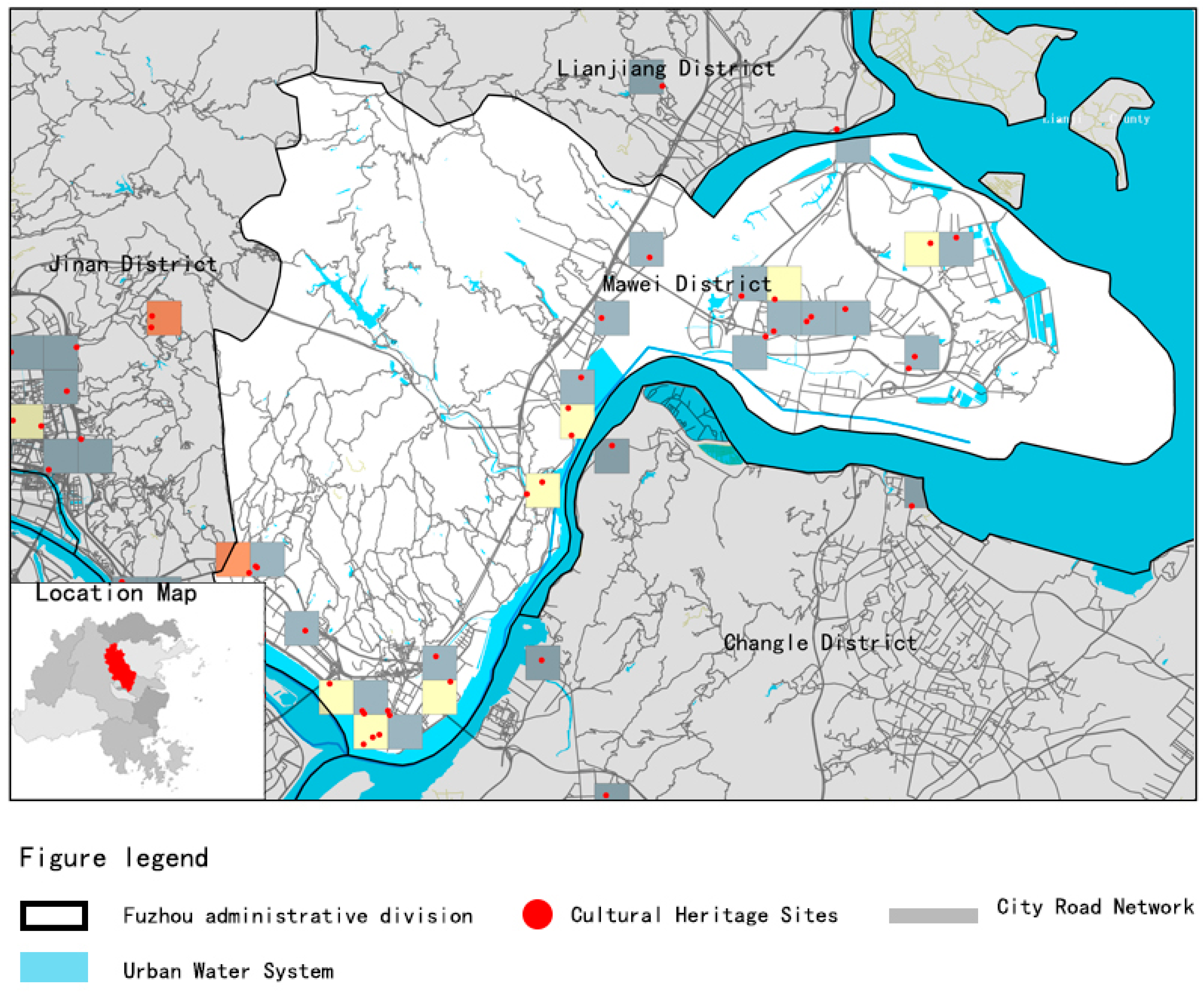
The data of Fuzhou city boundary and county-level administrative districts under Fuzhou were downloaded in .gdb format from Fujian Basic Geographic Information Center (www.fjgis.org.cn) and opened in GIS (Figure 7 and Figure 8).
After adding coordinate data using ArcGIS10.8 to connect building information, the GCS_WGS_1984 geographic coordinate system, WGS_1984_UTM_Zone_49N projection coordinate system used in GIS, and other related information were added.

2.3. Research Framework

In this paper, the following four research methods are used:
  • To summarize and classify the amount of cultural heritage in the city of Fuzhou, the age of establishment, conservation and reuse, etc. with the help of summary statistics in ArcGIS10.8 software and to calculate the main distribution areas (counties) of cultural heritage.
  • To establish cultural heritage corridors, the distance from each cultural heritage site to the centerline of the main stream of the Min River is measured, and a heritage corridor (buffer zone) with the backbone of the main stream of the Min River with a width of about 4000 m is established.
  • Determination of the node area based on the aggregation degree calculation. Using the ArcGIS fishnet tool to create modal cells in the area of Fuzhou City, the point density analysis tool was used to calculate the aggregation degree based on the number of cultural heritage points in each cell.
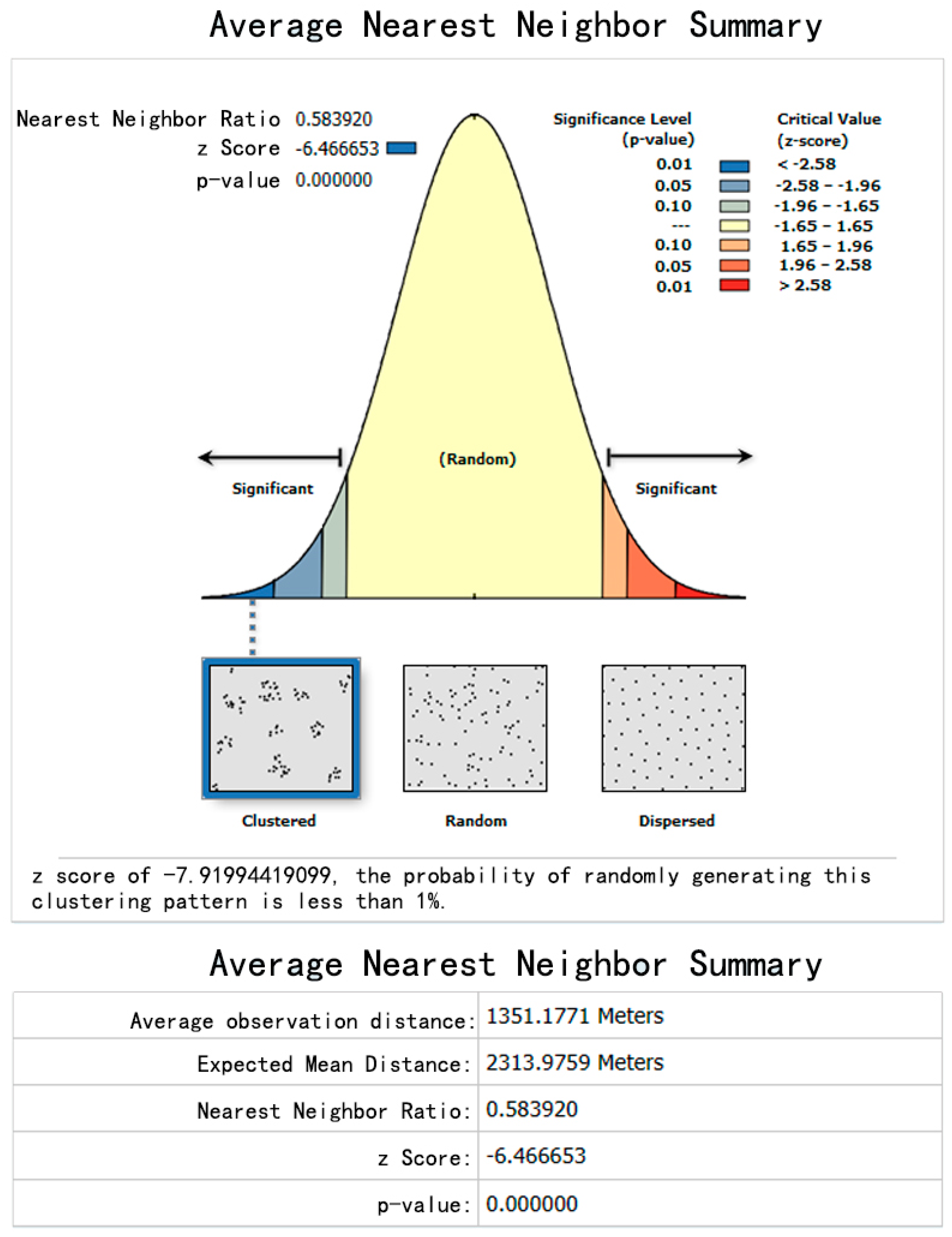
  • The nearest neighbor analysis was used to determine the distribution of spatial patterns within the node area and then to identify the main concentration areas of Fuzhou cultural heritage in the city.

2.4. Research Methods

1.
Aggregation Analysis
Aggregation is the spatial dispersion and pattern of the site distribution, and it is involved in the analysis of the superposition of sites. The analysis of agglomeration is of great significance to the study of cultural heritage, as follows: through the analysis of agglomeration of cultural heritage, it is possible to understand the laws of the people’s choice of sites over the millennia; through the analysis of agglomeration of sites, it is possible to summarize the spatial distribution of cultural heritage sites, which is also an important clue and reference for the excavation of new sites. Usually, the aggregation of cultural heritage distribution can be calculated by density, and the formula is expressed as follows:
S n = T n A Sn
S n is the degree of aggregation in the nth cell, T n is the number of cultural heritage points in the nth cell. A is the basic cell area [32].
2.
Nearest neighbor analysis
For the study of spatial distribution of cultural heritage, it is usually regarded as point-like elements. The common types of spatial distribution of point-like elements are discrete, random, and agglomerative, which can be discriminated by the nearest distance, with discrete distribution having the largest nearest distance, random distribution the second, and agglomerative distribution the smallest. The nearest proximity distance is a geographic index indicating the degree of mutual proximity of point-like elements in geographic space, and the nearest proximity ratio can well reflect the spatial distribution characteristics of point-like elements, which is calculated as the ratio of the actual nearest proximity distance to the theoretical nearest proximity distance (i.e., the theoretical value in the case of random distribution), and its formula is expressed as follows:
ANN = D ¯ O D ¯ E
where D ¯ O is the average of the measured distances between each point and its nearest neighbor; D ¯ E is the average distance of the random distribution of points:
D ¯ E = 0 . 5 n A
3.
Buffer Zone Analysis
According to the existing maps, the ancient stagecoach routes of Han, Tang, Northern Song, Southern Song, Yuan, Ming, and Qing Dynasties (hereinafter referred to as Han–Qing Ancient Stagecoach Routes) and the main and trunk streams of the Minjiang River were integrated into the GIS, and the equidistant buffer zones with widths of 500 m, 1000 m, 1500 m, and 2000 m were established, respectively, and the number of cultural heritage points in the buffer zones, their founding dates, and architectural types were counted and their spatial distribution patterns were analyzed.

3. Results

3.1. Overview of the Current Situation of Fuzhou’s Cultural Heritage

As of 22 March 2022, there are 324 national, provincial, and municipal cultural relic protection units and 309 key protection and general protection historical and landscape buildings in Fuzhou; from the GIS aggregated statistics, it is calculated that the cultural heritage of Fuzhou is mainly concentrated in CangShan District, Mawei District, Gulou District, and Taijiang District (Figure 9 and Figure 10).
Based on the available historical maps of Fuzhou and the time of building construction, the study period can be divided by dynasties. It can be seen that the cultural heritage was built mainly during the Qing Dynasty, Song Dynasty, Ming Dynasty, and Republic of China (Table 4).
In recent years, Fuzhou City has vigorously promoted the protection and reuse of historical and cultural heritage, and the “Opinions on Strengthening the Protection of Cultural Relics in Urban Construction” measures were issued by the municipal government on 2 August 2019 [33]. Cultural heritage sites within Fuzhou, such as Fuzhou Sanfang Qi Xiang, Zhu Zi Fang, Shang Shang Shang Hang historical and cultural district, Yantai Mountain historical and scenic area, and the group of cultural sites of ship administration, are listed as key objects for protection and restoration. Due to the limited economic strength and lack of relevant policies, funds, and talent support, the protection of cultural heritage in Lianjiang, Changle, and Yongtai districts (counties) is still mainly independent, and their protection efforts are far from those of Gulou District, Taijiang District, and CangShan District.

3.2. Attribute Determination of Fuzhou Cultural Heritage Corridor

From the previous research results, it is known that the ideal model of heritage corridor consists of four parts: green corridor, nodes, heritage points, and interpretation system, and the relationship can be illustrated in the following figure (Figure 11) [7]. In this paper, the determination of the reasonable value of buffer width and the node area will be the main research direction.
Due to the complexity of the constituent elements and functions of heritage corridors, there has been no clear definition of a reasonable value for the corridor width. The reasonable value of “heritage corridor width” is derived from the analysis of existing successful cases at home and abroad. For example, the Ohio and Illinois Canal National Heritage Corridor in the United States is 2–15 km [34], and the Wabash River Heritage Corridor in Indiana, USA is 0.8–3.2 km [35]. Judging from the results of previous studies, the corridor width is not a fixed value. In this study, the initial value of the set buffer was set to 500 m, 1000 m, etc., in such a stepwise increment to determine a reasonable corridor width value.
The cultural heritage coordinate points within the city of Fuzhou were imported into ArcGIS10.8 software, and spatial connections were established after setting buffers, to determine the existence of cultural heritage corridors in Fuzhou. The circular buffer zone tool of ArcGIS10.8 software was used to establish buffer zones of 500 m, 1000 m…4000 m widths for the main water and land transportation corridor skeletons in turn. Further, the distance from each cultural heritage point to the centerline of the corridor backbone was measured using the spatial connection tool and summary statistics to calculate the percentage of the total number of points. The results showed that there were 178, 291, 377, and 447 cultural heritage items within 1000 m, 2000 m, 3000 m, and 4000 m of the buffer zone, respectively, and accounted for 29.6%, 48.3%, 62.6%, and 74.3% of the total number of points, respectively (Figure 12 and Figure 13).
Results of establishing buffer zones on ancient stagecoach routes from the Han to Qing dynasties: from a width of 2000, the number of cultural heritage increases less, so the buffer distance is set to 2000 m; the number of cultural heritage points in the 2000 m buffer zone reaches 229, accounting for 39.7% of the total number of cultural heritage points, which accounts for a small proportion, and it is judged to be less connected with the distribution of cultural heritage points, so it is not further considered in the following (Table 5 and Figure 14).
From the above calculation, it is concluded that there exists a cultural heritage corridor width of 4000 m in Fuzhou City with the main water and land transportation routes as the backbone, and the spatial layout of cultural heritage has a strong dependence on the water transportation routes (Figure 15).
Cultural heritage node areas were determined by the calculation of aggregation degree. A cell with a modulus of 1000 m × 1000 m was created within the area of Fuzhou City (11,968 square kilometers) using the Create Fishing Net tool of ArcGIS software, and then the cultural heritage aggregation degree was calculated based on the number of cultural heritage points within each cell. According to the above formula for calculation, the number of cultural heritage points in each cell and the aggregation degree can be determined, and then GIS is used to calculate the latitude and longitude coordinates of the geometric center point of the cell to mark the geographical location of each cell. Then, the main spatial node areas and distribution patterns of cultural heritage in Fuzhou are determined. According to the above rules, the area of Fuzhou City was divided and 12,809 basic cells were obtained. The aggregation degree of the cells was calculated according to the formula, and there were 232 places with aggregation degree calculation results, mainly in Gulou District, Taijiang District, and Cangshan District of Fuzhou City. The highest value of the data is 25, the lowest value is 0, and the median value is 10. There are 12 cells with aggregation values above 11, and the specific locations and the number of cultural heritage points included are shown in the table (Table 6).
According to the results of aggregation degree calculation and grading, there are 11 cells with an aggregation degree greater than or equal to 10 as the boundary, classifying three major cultural heritage point node areas and one special node area in Fuzhou: Node A (Gulou Cultural Heritage Node Area), Node B (Taijiang Wharf Cultural Heritage Node Area), Node C (Guling Cultural Heritage Node Area), and Node D (Mawei Special Cultural Heritage Node Area).

3.3. The Spatiotemporal Aggregation of Fuzhou Cultural Heritage

3.3.1. Node A: Drum Tower Cultural Heritage Node Area

The node area is located in the Gulou District of Fuzhou, with more cultural heritage sites concentrated within the old city of Fuzhou. Gulou District is located in the northwestern part of the urban area of Fuzhou, which is now the seat of provincial and municipal party and government offices and the core of the national historical and cultural city. Inside are the famous Sanfang Seven Lanes, Zhuzifang, and other historical and cultural districts of Fuzhou. There are also several national cultural relic protection units in the area, such as the Hualin Temple, the Kaiyuan Temple, the former residence of Lin Zexu, and the Temple of Literature.
The ancient city of Fuzhou is mainly located in the present-day Gulou District, north of the Min River, due to geographical conditions, as the Min River influences the extension of the city to the south at some level. There are 99 cultural heritage sites in this node area, mainly in the center of the old city (Figure 16).
Using the above data, the nearest neighbor analysis was used to rank and determine the distribution pattern of cultural heritage sites and then to determine the main concentration of cultural heritage in Fuzhou, which is expressed as the ratio of “average observed distance” to “expected average distance”. The expected average distance is the average distance between neighbors in a hypothetical random distribution. It is expressed by the formula:
ANN = D ¯ O D ¯ E
The mean nearest neighbor analysis tool in GIS can be implemented to produce the results shown in the figure, yielding an ANN value of 0.59, a Z-score of −7.91, and a p-value of 0. The resulting combined theory illustrates that the spatial distribution of cultural heritage sites within the node area is a significant aggregation pattern (Figure 17).
The distribution of cultural heritage sites in Node A is characterized by three points: first, in terms of building types, ancient buildings account for more than 75% of the known building types (Figure 18). Important historical sites and representative buildings of modern times, cave temples and stone carvings, and ancient tombs account for a relatively small proportion. Secondly, in terms of the current situation of conservation and utilization, it is located in the urban center of Fuzhou, and the overall reuse and conservation situation is better. Most of the temples are still in use, most of the residential buildings are transformed into commercial streets, such as Sanfang Qi Xiang and Zhuzifang, and most of the houses of famous people are transformed into museums, such as Lin Zexu’s house and ancestral hall. Finally, most of the buildings were built during the Qing Dynasty, due to the development of sea transportation after the Yuan Dynasty and the development of the commodity economy and maritime trade in Fuzhou during the Ming Dynasty, which contributed to the economic prosperity of the city, when the Min River was no longer an obstacle to the southward expansion of the city [31].
It is calculated that 80% of the points in the Gulou District are gathered inside the ancient city. The remaining 20% are scattered outside the old city, with the ancient tombs category occupying 26%. The ancient buildings and recent important historical sites and tabular buildings category were mostly built during the Republican and Qing dynasties (Figure 19).
Some of the more important cultural heritage sites in this nodal area include the Great Hall of Hualin Temple, the Three Square Seven Lanes Complex, Wushi Mountain, Yu Mountain Cliff Carvings and Statues, Xizhen Temple, Fuzhou Temple of Literature, Lin Zexu House and Ancestral Hall, and Kaiyuan Temple (Figure 20).
Based on parameters such as the angle of rotation, the length of the long axis, and the length of the short axis of the standard deviation ellipse, the spatial distribution of industrial heritage in the seven periods can be divided into two intervals. In the four periods from 1895 to 1957, the ellipse is horizontally distributed, with an ellipse rotation angle range of 62.70–99.64°, a long axis length range of 20.56–32.29 km, and a short axis length range of 4.12–21.66 km; in the remaining three periods, the ellipse is vertically distributed, with an ellipse rotation angle range of −16.67–16.38° (clockwise is positive), a long axis length range of 46.64–85.04 km, and a short axis length range of 27.56–35.53 km. Accordingly, it can be found that when the ellipse is laid out horizontally, it is located near the Haihe River, and the ellipse has a smaller area and a higher flatness, indicating a high degree of industrial heritage concentration; when the ellipse is laid out vertically, the distribution location is not fixed, and the ellipse has a larger area and a lower flatness, indicating a low degree of industrial heritage concentration.

3.3.2. Node B: Taijiang Wharf Cultural Heritage Node Area

In its 2200 years of development, Fuzhou was less affected by wars than the cities in the Central Plains, so its urban evolution was characterized by natural development, and the spatial form of the city also had corresponding characteristics. During the Yuan Dynasty, the two banks of the Nantai River (CangShan District and Taijiang District) became a prosperous area due to the development of maritime transport, and the “Wanshou Bridge” and the “Jiangnan Bridge” were built across the southern and northern harbors of the Nantai River, so that the urban area gradually expanded to the foot of Yantai Mountain [30].
Taijiang is located in the middle of the urban area of Fuzhou and is an important trade center of Fuzhou [36]. It is the main inland port area on the lower reaches of the Min River and a distribution center for goods upstream and downstream (Figure 21). Located on Nantai Island in the south of the Fuzhou urban area, CangShan is only across the river from the Tai River. A large number of Western-style architectural complexes such as Romanesque, Gothic, and Baroque are preserved in the area, especially foreign consulates, customs houses, and foreign banks, forming the unique architectural characteristics and appearance of CangShan District. Due to its location on the downstream of the Min River, the convenient waterway transportation promotes commercial development and is the commodity distribution center in northern Fujian. “Bamin products, tea, wood, and paper are the major products, which are not produced from Fuzhou. However, the huge merchants, whose operations were set, must take Fuzhou as the” [37], and the Taijiang wharf was the collective name of all the passenger and freight terminals in the port of Taijiang.
Before modern times, the functional zoning of Fuzhou City was clear, which can be described as a double-headed layout, that is, the political center and economic center are located in the north and south of the city, respectively [38]. The political center’s location did not vary much over time. However, the change in the commercial and economic center of the city is characterized by a gradual shift to the south along the central axis of the city [39]. During the Tang and Song dynasties, the commercial center was located along the Taihe River, and during the Ming and Qing dynasties, it shifted southward to form a port commercial center along the Taijiang River, which was independent of the old city and became more and more prosperous after the opening of five ports for commerce. The Taijiang Terminal, located along the Min River south of Taijiang, is the collective name for all the passenger and cargo terminals in the port of Taijiang. There are 70 cultural heritage sites in this node area, mainly concentrated in this Minjiang River to Taijiang River shoreline section.
The results based on the mean nearest neighbor analysis tool in the GIS software are shown, yielding an ANN value of 0.38, a Z-score of −11.93, and a p-value of 0 (Figure 22). The obtained combination theory illustrates that the spatial distribution within Node B is a significant aggregation pattern.
The heritage sites within Node B have the following characteristics: firstly, in terms of building construction dates, there are 70 buildings within the node area with a total of 68 known construction dates, of which 22% are from the Qing Dynasty and 70% are from the Republic of China. The proportion of Republican buildings is 61.5% higher than the 8.5% in the cultural heritage node centered on the old city (Figure 23). This is side evidence of the increase in the number of modern building types due to the prosperous rise of both sides of the Taishan River under the influence of the Minjiang River transport. Secondly, in terms of building types, there are 70 known building types, and the recent important historical sites and tabular buildings account for 87%, which is 69.3% higher than the percentage of 18.6% in the cultural heritage node area centered on the ancient city in Gulou District. Finally, on the utilization of the current situation: most of the modern commercial buildings form a busy commercial street on both sides of the Taijiang River and CangShan District. The buildings in the node area are mainly divided into foreign houses, houses, villas, banks, and chamber of commerce buildings. Among them, the number of modern foreign houses is the highest.
In terms of building types, important historical sites and representative buildings in modern times account for more than 66% of the known building types, and ancient buildings account for 34%. In terms of building construction time, they were mostly built in the Republic of China and Qing Dynasty. This is because at the beginning of the Qing Dynasty, Taijiang District, located south of the ancient city of Fuzhou and north of the Minjiang River, was not yet fully developed (Figure 23). After the Opium War, Fuzhou was established as one of the “five ports of commerce”, and the development of foreign trade in Fuzhou reached its peak [40]. The southern section of the Minjiang River in Taijiang District was close to the port, and the areas of Yizhou, Gangzhou, and Cangxiazhou became the distribution centers for cargoes, and the number of foreign companies increased due to the active trading of goods. In this way, Fuzhou Old Town and Taijiang District became two groups with different functions. The Old Town is the political center of Fuzhou in the north, while Taijiang District is the commercial center of Fuzhou. Some of the more important cultural heritage sites in this nodal area are the Gutian Guild Hall, the Shangxianghang Merchant Complex, the former residence of Hou Depeng, the Fuqing Guild Hall, the Sanshan Guild Hall, and the Shangxianghang Historical and Cultural District of Fuzhou (Figure 24).

3.3.3. Node C: Guling Cultural Heritage Node Area

Guling is located in the northern part of Gushan in the eastern suburbs of Fuzhou and is now generally referred to as Guling. Guling is known by modern Western missionaries as one of the four major summer resorts in China, along with Guling in Lushan, Jiangxi, Moganshan in Zhejiang, and Jigongshan in Henan [41].
The “summer resort” is another manifestation of the colonial rule of the Western powers in China in modern times, which is different from both the concessions and the foreigners’ residences. It is a villa residential area developed by foreigners in China for summer vacation.
Yixia Village is located in the Guling Scenic Area. The village is also a microcosm of modern China’s opening to foreign trade, with Guling and Fuzhou serving as ports of commerce and reflecting the collision of Chinese and foreign cultures in China’s modern history [42]. Since 1935, foreigners, merchants, doctors, priests, and officials built their summer homes in Guling. Three hundred and sixty-six villas, tennis courts, swimming pools, post offices, etc. were built in Guling, and Guling Old Street, a commercial street for foreigners, flourished for a while (Figure 25).
Guling Old Street is located in the middle of Yixia Village in the Guling Scenic Area, and its large-scale construction was recorded in 1886.
The results were obtained using the mean nearest neighbor analysis tool in the GIS software, yielding an ANN value of 0.40, a Z-score of −8.96, and a p-value of 0 (Figure 26). The combination of the results indicates that the spatial distribution of cultural heritage sites in Guling (centered on Yixia Village) is a significant aggregation pattern. The cultural heritage points in the node area are all distributed within Yixia Village, which is related to the development history of Guling.
Most of the buildings were built during the Qing and Republican dynasties, as the discovery and large-scale construction of Guling were closely related to the activities of the missionaries in Fuzhou in the modern era (Figure 27). Historical changes and the influence of foreign cultures have led to the collision of Chinese and Western cultures in the architecture of Guling, which includes both traditional Min-Chinese buildings and Western-style villas. Some of the more important cultural heritage sites in this node include the Universal Community Service, the Guling Post Office, the Guling Centennial Swimming Pool, etc. (Table 7, Figure 28).
Guling is located in the northeast of Fuzhou City. In terms of the current state of conservation and utilization, the overall reuse and protection are more general. The main problems are reflected in several aspects:
  • Lack of public facilities and weak connection with urban transportation;
  • Conflicts between new buildings and protected buildings;
  • Some buildings are not well protected because they cannot meet the functional needs of modern life.

3.3.4. Node D: Mawei Special Cultural Heritage Node Area

Fuzhou Mawei is located on the southeastern coast of the mainland, near the delta at the mouth of the Min River, as Mawei relies on the original late Qing Dynasty shipyard bureau based on the development of the rise. During the Tongzhi period of the Qing Dynasty, Zuo Zongtang, the governor of Fujian and Zhejiang, applied to open a shipyard. Its planning ideas are reflected in: “Fuzhou Mawei Mountain, for the province of Austria, set up a shipyard in Mawei in the manifold. The circumference of the dock is 450 feet. The iron ship trough was 30 zhang long and 15 zhang wide, and could build 2500 tons of ships” [43]. The cultural heritage of Mawei District is mostly of the industrial heritage type and is characterized by a diversity of architectural types. The industrial heritage is the most numerous and dominant; the Fuzhou Shipyard is the most famous (Figure 29).
Industrial building heritage is relatively recent, and industrial buildings have the structural characteristics of neat structural layout and mature structural systems. Often, their architectural life is longer than their functional life, although some buildings have lost their original production function with the development and changes in modern society, but their architectural structure is still relatively stable and complete. Some of the more important cultural heritage sites in this node area are the cliff carvings of Ma Lim Shan, Luoxing Pagoda, the British Consular Branch, and the Mawei Shipyard. The spatial distribution of cultural heritage sites in Mawei District has the following characteristics:
  • Modern industrial buildings and modern industrial buildings coexist.
  • The industrial heritage of waterway transportation is mostly concentrated at the entrance of the city to the sea, which can be considered a special protection node in the cultural heritage corridor along the Minjiang River in the subsequent protection construction.
  • There are various building types, among which production buildings are the main ones.
  • Most of its buildings are well preserved.

4. Discussion

At present, there are many guiding theoretical achievements or protection strategies in the research on heritage corridors, such as exploring the basic components and spatial evolution of heritage corridors, advocating the revitalization of inheritance and systematic inheritance, etc., or constructing theoretical analytical frameworks or policy systems based on the knowledge of the relevant fields. The relevant results have their focus on content, and together they provide the scientific basis for the protection and management of cultural heritage in both theory and practice. The discussion on the spatial distribution of cultural heritage in this paper is the basis of the research on the construction of heritage corridors and heritage protection, which enriches the theoretical system of heritage corridors to a certain extent, enhances the scientific nature of the construction, management, and utilization of the corridors, and promotes the development of the region. Specifically, there are the following points:
First, cultural heritage, as the main body of corridors, determines the spatial scope of corridors. The article uses GIS buffer zone analysis to determine the spatial scope of major and minor corridors, which can solve the problem of “how to delineate the spatial scope” in cultural heritage protection [44]. This method integrates the waterway transportation system into a corridor system linked by cultural heritage, emphasizes the relationship between the distribution of cultural heritage and corridors, and conforms to the concept of “cross-regional heritage corridor protection and utilization” [45]. This is conducive to further expanding the perspective of heritage conservation research and promoting the trend of multidisciplinary integration of heritage conservation, urban planning, and geography.
Secondly, heritage corridors span multiple regions, and their heritage resources, environment, and economic development are uneven, and it is often unrealistic to protect and utilize the whole line at the same time. The most effective way is to prioritize the protection and development of important areas, which determines the efficiency of the protection and utilization of cultural corridors. Because tourism is one of the important ways to protect and utilize cultural corridors, areas with a high concentration of cultural heritage and obvious historical features become the selection criteria for corridors. The corridor can be divided into general and special gathering areas from the conditions of heritage resources and transportation and promote the overall protection and development of the corridor through its radiation, which solves the problem of “spatial dispersion of cultural heritage resources is difficult to unify” [46].
Thirdly, in this paper, the spatial relationship between the gathering areas and the corridor as a whole is shown more intuitively, which helps to expand the scope of application of the concept of cultural corridors in the study of cultural heritage protection in other regions and different cultural environments.

4.1. Shortcomings of the Article

  • In the process of heritage resource research, faced with a vast sea of literature and hundreds of widely distributed related heritage points, the research is difficult and there are bound to be omissions. Many heritage resources could not be photographed in the field, which is deeply regrettable. More detailed basic research is required for follow-up.
  • This paper explores the characteristics of the spatial pattern of cultural heritage in Fuzhou City, expands the application of GIS in heritage protection, and provides a proven research method for the spatial planning and protection of cultural heritage in the future. However, due to the difficulty of obtaining three-dimensional data, this paper only obtains the point location of the cultural heritage and does not obtain the three-dimensional information of each building and fails to study the scale characteristics and planning layout, which need to be further studied and analyzed in the future.
  • In the construction process of the heritage corridor, this paper draws more on the holistic protection idea and construction method under the theory and extends and expands its concept by combining it with the actual situation of Fuzhou.
  • Although we entered the heritage resources through the GIS10.8 software and determined the general construction scope of the Fuzhou cultural heritage corridor, it is still not precise enough at the micro level, and the program needs to be discussed and improved at a deeper level.

4.2. Prospects

  • This study is expected to guide the delineation of cultural heritage protection areas in Fuzhou City, the study of architectural heritage reuse mode and tourism development, and the construction of corridors and multiple protection of the Minjiang River water system and cultural heritage, providing directions for the subsequent protection of the city’s cultural heritage. This study is expected to guide the delineation of cultural heritage protection areas, architectural heritage reuse, and tourism development, as the construction of corridors and multiple protection of the Minjiang River water system and cultural heritage in Fuzhou City, and to provide directions for the subsequent protection planning of cultural heritage.
  • On this basis, a systematic study of the spatial and temporal distribution characteristics of cultural heritage and the establishment of heritage corridors on the urban scale has been conducted, leading to conclusions of guiding significance for the protection of cultural heritage in Fuzhou. It provides a feasible technical route for the overall protection of cultural heritage in similar cities in China and even in East Asia and promotes the protection of local culture.

5. Conclusions

  • Determination of different periods and types of cultural heritage gathering areas in Fuzhou City.
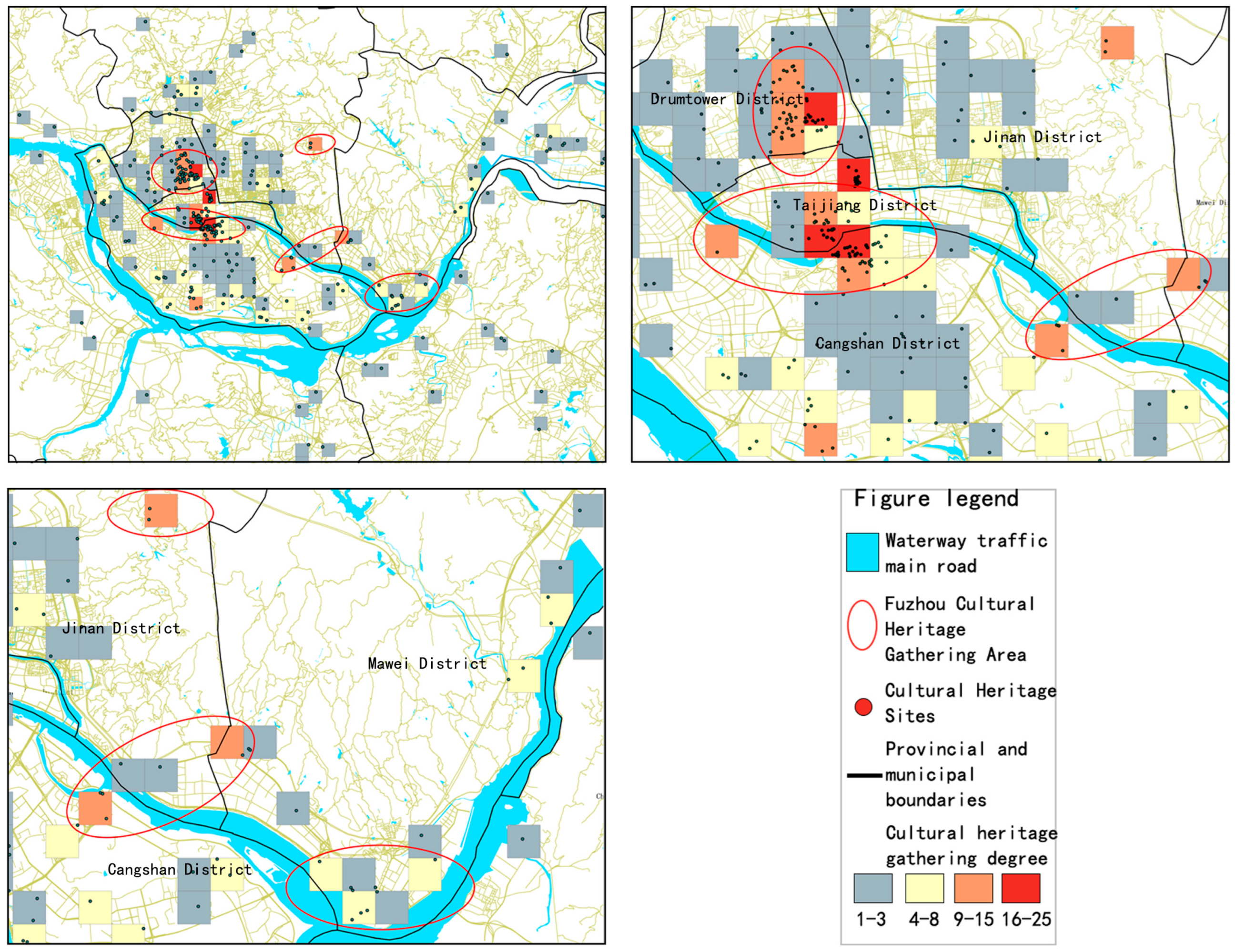
Through the above analysis, there are three cultural heritage node areas and one special cultural heritage node area in Fuzhou City, which are Node A (cultural heritage node area of Gulou District), Node B (cultural heritage node area around Taijiang Ferry Terminal), Node C (cultural heritage node area of Guling), and Node D (special cultural heritage gathering area of Mawei), Node A is located in the ancient city of Fuzhou, and Node B is located in the intersection of Taijiang and CangShan districts, which is in line with the trend of Fuzhou’s economic center moving southward since the Tang Dynasty, forming a certain scale of economic clusters below Taijiang and CangShan districts. Today, the “economic cluster” is still extending to Jinan District, Lianjiang County, Mawei District, and other neighboring areas. The Guling cultural heritage node in Jin’an District, a product of modern economic development, is located in the eastern part of Jin’an District, where large-scale construction activities are associated with missionaries during the Qing and Republican periods.
2.
The existence of cultural heritage corridors carried by the Min River as the main land and water transportation route.
After the above study, there are two main characteristics of cultural heritage node areas with major waterway transportation as the axis, which are consistent with the expected results. The spatial distribution of cultural heritage in Fuzhou City exists as a cultural heritage corridor with Minjiang River as the main water and land transportation route. The width of the corridor is 4000 m, and the closer to the main cultural heritage distribution the denser it is, and the spatial layout of cultural heritage is more dependent on water routes.
3.
Research on conservation strategies based on spatial distribution characteristics.
The cultural heritage corridor contains linear resources of water and land routes as well as cultural heritage and other types of heritage. After thousands of years of historical development, linear heritage and point heritage complement each other and develop together. Therefore, the construction of the cultural heritage corridor should start with general protection and utilization and preserve the originality and diversity of the Minjiang River and the ancient stagecoach routes, the traditional cultural heritage along the routes, and the cultural heritage resources in other regions.
Therefore, this paper proposes to construct a macro-scale heritage corridor system in Fuzhou, draw the overall structure of heritage corridors, and divide them into major and minor heritage corridors according to the differences in the number, type, and concentration of cultural heritage along the corridors.
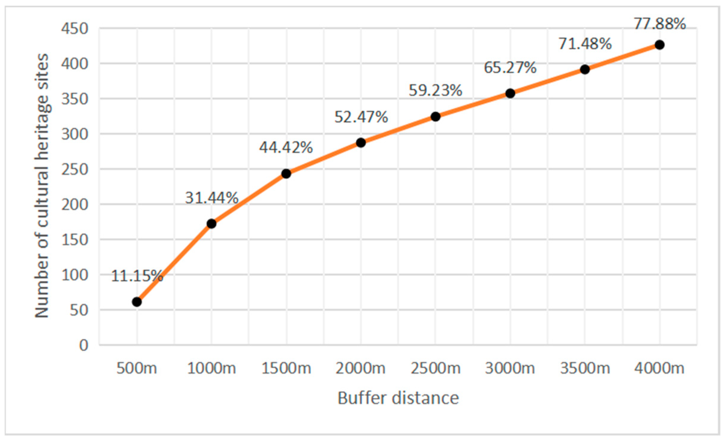
Construction of main corridor: the main corridor mainly refers to the high degree of cultural heritage gathering, and there are multiple cultural heritage nodes with obvious historical features in the corridor. According to the previous analysis, this area is centered on the backbone of the Minjiang River on both sides of the region of 0~4000 m as the main corridor. This area contains 77.88% of the cultural heritage of Fuzhou City.
The heritage in this area can be developed and constructed to an appropriate degree, but it is desirable to leave a proper buffer zone as much as possible. In addition, the development of cultural heritage in this area should focus on the sustainable development of the heritage corridor as a whole and add appropriate service facilities, such as farmhouses or rural stations.
As can be seen from the above, this part of the corridor is mainly dominated by the main waterway transportation channel (Minjiang River) in Fuzhou. This section of the corridor is rich in architectural types, heritage concentration, and composition. At the same time, it is rich in natural geographic landscapes, which are of great value for its holistic conservation and utilization.
Construction of secondary corridor: the secondary corridor mainly refers to the area with a high concentration of cultural heritage and obvious historical features, according to the previous analysis and the ancient stagecoach route as the backbone on both sides of the area from 0m to 1500 m, which contains 49.98% of the cultural heritage of Fuzhou City (Figure 30). This section of the corridor serves as a supplement to the Minjiang section of the corridor.

Author Contributions

J.Z. and L.J. conceived the whole structure, accomplished the data collation, and wrote the paper. X.W., Z.C. and S.X. performed the validation and revised the paper. All authors have read and agreed to the published version of the manuscript.

Funding

The project is supported by the National Natural Science Foundation of China (52008175), the National Natural Science Foundation of China (52078223), National Social Science Foundation Art Major Project of China (21ZD01), and the Fundamental Research Funds for the Central Universities of Huaqiao University (ZQN-919).

Data Availability Statement

The data of this research project can be obtained through application to the authors and review and cannot be used for commercial purposes. The data are not publicly available due to privacy.

Acknowledgments

Thanks to the Architectural Heritage Conservation Laboratory, School of Architecture, Huaqiao University for helping with the research.

Conflicts of Interest

The authors declare no conflicts of interest.

References

  1. Fuzhou Bureau of Natural Resources and Planning. Contents of “Fuzhou City Master Plan (2011–2020)” Published_Master Plan_Fuzhou Bureau of Natural Resources and Planning; Fuzhou Bureau of Natural Resources and Planning: Fuzhou, China, 2022. [Google Scholar]
  2. Li, J.D.; Yang, X.F.; Sitzenfrei, R. Rethinking the Framework of Smart Water System: A Review. Water 2020, 12, 412. [Google Scholar] [CrossRef]
  3. Yang, Y. Preservation and Regeneration Practices on Decaying Historical District in Fuzhou, China. The Case of Shangxia Hang District. Master’s Thesis, ARC I—Scuola di Architettura Urbanistica Ingegneria delle Costruzioni, Milano, Italy, 2019. [Google Scholar]
  4. Sun, F. Research on the protection and development of cultural heritage from the perspective of sustainable development: The case of Sanfang Qilang in Fuzhou. Fujian Forum (Humanit. Soc. Sci. Ed.) 2011, 12, 86–92. [Google Scholar]
  5. Searns, R.M. The evolution of greenways as an adaptive urban landscape form. Landsc. Urban Plan. 1995, 33, 65–80. [Google Scholar] [CrossRef]
  6. Flink, C.A.; Searns, R.M. Greenways: A Guide to Planning, Design, And Development: Greenways: A Guide to Planning, Design, and Development; National Academy of Sciences: Washington, DC, USA, 1993. [Google Scholar]
  7. Wang, Z.F.; Sun, P. Heritage corridors—A newer approach to heritage conservation. Chin. Gard. 2001, 5, 86–89. [Google Scholar]
  8. Kihn, C.C.; Eugster, J.G.; Steiner, F.; Judd, M.; Gerdtz, N. Conservation options for the Blackstone River Valley. Landsc. Urban Plan 1986, 13, 81–99. [Google Scholar] [CrossRef]
  9. Byrne, D. Heritage corridors: Transnational flows and the built environment of migration. J. Ethn. Migr. Stud. 2016, 42, 2351–2369. [Google Scholar] [CrossRef]
  10. Éndez, M.L.; Lmo, R.M.; Ruiz, R.; Yala, D.P. An Interdisciplinary Methodology for the Characterization and Visualization of the Heritage of Roadway Corridors. Geogr. Rev. 2016, 106, 489–515. [Google Scholar]
  11. Lin, F.; Zhang, X.; Ma, Z.; Zhang, Y. Spatial Structure and Corridor Construction of Intangible Cultural Heritage: A Case Study of the Ming Great Wall. Land 2022, 11, 24. [Google Scholar] [CrossRef]
  12. Biscaya, S.; Elkadi, H. A smart ecological urban corridor for the Manchester Ship Canal. Cities 2021, 110, 103042. [Google Scholar] [CrossRef]
  13. Li, H.; Li, J.H.; Wang, W.J.; Li, G.Y. Landscape Pattern Evolution and Ecological Protection Planning on Simao to Ninger Segment of the Ancient Tea Horse Road. In Proceedings of the International Conference on Energy Development and Environmental Protection (EDEP 2017), Guilin, China, 18–20 August 2017; pp. 325–331. [Google Scholar]
  14. Hoppert, M.; Bahn, B.; Bergmeier, E.; Deutsch, M.; Epperlein, K.; Hallmann, C.; Müller, A.; Platz, T.V.; Reeh, T.; Stück, H.; et al. The Saale-Unstrut cultural landscape corridor. Environ. Earth Sci. 2018, 77, 58. [Google Scholar] [CrossRef]
  15. Jin, C.; Yu-Qi, L.U. The Types Division And Corridors Construction Of Beautiful Village Construction In County Level—A Case Study of Deqing, Zhejiang Province. Resour. Environ. Yangtze Basin 2015, 24, 1819–1825. [Google Scholar]
  16. Liu, H.; Wang, Y. Construction and evaluation of traditional village cultural landscape safety corridor: A case study of Anyi ancient village in Nanchang. J. Nanchang Inst. Technol. 2019, 38, 50–59. [Google Scholar]
  17. Chen, H.; Cao, D.; Zou, Y.; Meng, S. Construction of Corridor of Architectural Heritage Along the Line of ZiJiang River in Hunan Province in the Background of the Tea Road Ceremony. In Proceedings of the 3rd World Multidisciplinary Civil Engineering, Architecture, Urban Planning Symposium (WMCAUS 2018), Praga, Czech Republic, 18–22 June 2018. [Google Scholar]
  18. Orbali, D.A.; Woodward, S. A Railway ‘Route’ as a Linear Heritage Attraction: The Hijaz Railway in the Kingdom of Saudi Arabia. J. Herit. Tour. 2008, 3, 159–175. [Google Scholar] [CrossRef]
  19. Li, H.; Jing, J.; Fan, H.; Li, Y.; Liu, Y.; Ren, J. Identifying cultural heritage corridors for preservation through multi dimension alnet work connectivity analysis—A case study of the ancient Tea-Horse Road in Simao, China. Landsc. Res. 2021, 46, 20. [Google Scholar] [CrossRef]
  20. Severo, M. Heritage Networks. Managing Network Cultural Heritage with the Web; VDM Verlag Dr. Müller: Saarbrücken, Germany, 2012. [Google Scholar]
  21. Wang, H.D.; Feng, X. Planning of slow-traveling facility system for the ancient great wall cultural heritage corridor in da tong, shan xi province. Landsc. Archit. Front. 2019, 7, 18. [Google Scholar] [CrossRef]
  22. Li, W.; Yu, K. The new trend of world cultural heritage conservation—Cultural routes. Urban Issues 2005, 27, 7–12. [Google Scholar]
  23. Wang, F.; Lian, H. Research progress and development trend of linear space. Huazhong Archit. 2007, 25, 88–91. [Google Scholar]
  24. Fu, C.-W.; Xie, J.-M.; Chen, L.; Liang, J. Neighborhood-scale breeze corridor planning for spatial response and implementation management: The case of Suqian City. J. Urban Plan. 2019, 3, 81–86. [Google Scholar]
  25. Qiang, Z. Construction of Industrial Heritage Corridors in the Jiangnan Section of the Beijing-Hangzhou Grand Canal. Ph.D. Thesis, Beijing University, Beijing, China, 2007. [Google Scholar]
  26. Yu, W.; Yu, K.; Li, D. A theoretical framework for heritage corridors and the overall conservation of the Grand Canal. Urban Issues 2004, 1, 28–31. [Google Scholar]
  27. Li, F.; Song, J. Corridor heritage: Concepts, theoretical sources and value judgments. Hum. Geogr. 2010, 25, 74–77. [Google Scholar]
  28. Wang, X.; Chen, B.; Zhang, Y. Conservation and utilization of industrial architectural heritage in Shenyang. Ind. Archit. 2007, 9, 51–54. [Google Scholar]
  29. Wang, Y. Study on the Conservation and Construction of Heritage Corridors of Nanjing Ming City Wall. Ph.D. Thesis, Nanjing Forestry University, Nanjing, China, 2015. [Google Scholar]
  30. Li, Y.; Chen, Y. A borrowed analysis of the historical spatial evolution of Fuzhou City. Shanxi Archit. 2021, 47, 14–16+36. [Google Scholar] [CrossRef]
  31. Jiang, L.; Guo, Y. Research on the Evolution Law and Development Strategy of Urban Form–Taking Fuzhou City as an Example. Chin. Foreign Archit. 2017, 9, 75–78. [Google Scholar] [CrossRef]
  32. Zhang, J.; Xu, S.; Nobuo, A. Study on the construction of industrial heritage corridor system in Tianjin. New Archit. 2021, 1, 136–140. [Google Scholar]
  33. Available online: http://www.fuzhou.gov.cn/zgfzzt/lswhmcgwh/lswhmc/zcfg/201910/t20191012_3057638.htm (accessed on 25 March 2022).
  34. Available online: https://www.ohioanderiecanalway.com/ (accessed on 25 March 2022).
  35. Available online: https://www.in.gov/wrhcc/ (accessed on 25 March 2022).
  36. Fuzhou Local History Compilation Committee. Fuzhou City Zhi; China Literature and History Press: Beijing, China, 2018; Volume 1. [Google Scholar]
  37. Lu, M.; Taijiang District (Fuzhou City) Government. Fuzhou Shuanghang Zhi; Fangzhi Publishing House: Beijing, China, 2006. [Google Scholar]
  38. Liu, X. Study on the Evolution of Urban Form in Modern Fuzhou. Master’s Thesis, Southwest Jiaotong University, Chengdu, China, 2006. [Google Scholar]
  39. Liu, X. Research on the development of urban form in Fuzhou based on self-organization theory. J. Fuzhou Univ. (Nat. Sci. Ed.) 2010, 38, 568–573. [Google Scholar]
  40. Xu, W. The integration and collision of Chinese and Western cultures: An example of Guling Old Street conservation planning. Fujian Archit. 2013, 5, 6–8. [Google Scholar]
  41. Gao, J. Letting History Shine into Reality: The Value of Guling Historical and Cultural Monuments in Fuzhou from the Perspective of Cultural Landscape. China Ethn. Expo 2020, 20, 194–195. [Google Scholar]
  42. Lin, Z.; Ji, S. Historical inheritance and development of traditional village architecture conservation in Guling, Fuzhou—A case study of Yixia Village. Small Town Constr. 2018, 36, 45–51. [Google Scholar]
  43. Zhao, E.; Miao, T.; Ke, X.; Wang, S.; Guo, Z.; Li, J.; Wu, S.; Wu, Y.; Ma, Q.; Xia, S.; et al. Qing History Manuscript; China Book Bureau: Shanghai, China, 2021. [Google Scholar]
  44. Cheng, S.; Zhang, Y. The key to high-quality development of national cultural parks. J. Tour. 2022, 37, 8–10. [Google Scholar] [CrossRef]
  45. Wu, Q.; Wen, Y. A Dutch heritage policy for spatial planning in the 21st century. Famous Cities 2022, 36, 46–52. [Google Scholar] [CrossRef]
  46. An, Z.; Zhou, S. Protection mechanism of cultural heritage in national cultural parks based on geographic scale transformation. Dev. Res. 2022, 20–30. [Google Scholar] [CrossRef]
Figure 1. Relationship between greenways, heritage areas, and heritage corridors.
Buildings 14 00121 g001
Figure 2. Statistics on the number and type of studies related to WOS heritage corridors from 1986 to 2021.
Buildings 14 00121 g002
Figure 3. Statistics on the number and type of studies related to WOS heritage corridors from 1986 to 2021.
Buildings 14 00121 g003
Figure 4. Statistics of the number of studies related to heritage corridors on the Internet of Knowledge, 2001–2021.
Buildings 14 00121 g004
Figure 5. Location map of Fuzhou City.
Buildings 14 00121 g005
Figure 6. The transformation from a bi-center city to a tri-center city.
Buildings 14 00121 g006
Figure 7. Data processing.
Buildings 14 00121 g007
Figure 8. Data processing.
Buildings 14 00121 g008
Figure 9. Distribution of cultural heritage types and their number.
Buildings 14 00121 g009
Figure 10. Distribution of cultural heritage types and their number.
Buildings 14 00121 g010
Figure 11. Model drawing of the heritage corridor.
Buildings 14 00121 g011
Figure 12. Cumulative percentage of the number of cultural heritage sites within the same distance.
Buildings 14 00121 g012
Figure 13. Anticipation map of the heritage corridor.
Buildings 14 00121 g013
Figure 14. The proportion of the number of heritage points in the buffer zone of ancient post roads from Han to Qing.
Buildings 14 00121 g014
Figure 15. Cultural heritage agglomeration and main distribution areas of cultural heritage.
Buildings 14 00121 g015
Figure 16. Distribution of cultural heritage in Gulou District.
Buildings 14 00121 g016
Figure 17. Average nearest neighbor analysis.
Buildings 14 00121 g017
Figure 18. Percentage of known building types in Gulou District and distribution of the number of buildings in Gulou District by dynasty.
Buildings 14 00121 g018
Figure 19. Distribution of cultural heritage sites outside the old city.
Buildings 14 00121 g019
Figure 20. Photographs of the current state of cultural heritage at Node A.
Buildings 14 00121 g020
Figure 21. Node B cultural heritage distribution.
Buildings 14 00121 g021
Figure 22. Average Nearest Neighbor Analysis.
Buildings 14 00121 g022
Figure 23. Period and type distribution of cultural heritage sites.
Buildings 14 00121 g023
Figure 24. Photographs of the current state of cultural heritage at Node C.
Buildings 14 00121 g024
Figure 25. Distribution of cultural heritage sites in Jinan District.
Buildings 14 00121 g025
Figure 26. Average nearest neighbor analysis.
Buildings 14 00121 g026
Figure 27. Types of cultural heritage and periods of construction.
Buildings 14 00121 g027
Figure 28. Enumeration of cultural heritage in Node C.
Buildings 14 00121 g028
Figure 29. Distribution of cultural heritage in Mawei District.
Buildings 14 00121 g029
Figure 30. Planning Map of Fuzhou Cultural Heritage Corridor System.
Buildings 14 00121 g030
Table 1. Data sources.
Data TypeTotal NumberNameNumberSource
Cultural Heritage Category Data277 locationsFuzhou National Cultural Relics Protection Unit29 locationsCentral People’s Government of the People’s Republic of China (http://www.gov.cn/index.htm accessed on 25 March 2022)
Fuzhou Provincial Cultural Relics Protection Unit128 locationsPeople’s Government of Fujian Province (https://fujian.gov.cn/ accessed on 25 March 2022)
Fuzhou Municipal Cultural Relics Protection Units120 locationsPeople’s Government of Fuzhou City (http://www.fuzhou.gov.cn/ accessed on 25 March 2022)
251 locationsFuzhou Historical Buildings309 locationsPeople’s Government of Fuzhou City (http://www.fuzhou.gov.cn/)
15 locationsFuzhou Traditional Villages15 locationsCentral People’s Government of the People’s Republic of China (http://www.gov.cn/index.htm)
4 locationsFuzhou Historical and Cultural District4 locationsPeople’s Government of Fujian Province (https://fujian.gov.cn/)
Vector map information Fuzhou City Boundary Fujian Province Basic Geographic Information Center (www.fjgis.org.cn accessed on 25 March 2022)
Fuzhou City Boundary
Fuzhou City Boundary in the Republican PeriodSelf-drawn from “the Historical Atlas of Fujian Province” and Zheng Lipeng’s “Study on the History of Fuzhou’s Urban Development”
Fuzhou City Boundary in the Song Dynasty
Fuzhou City Boundary in the Liang Period
Fuzhou City Boundary in the Tang Dynasty
Fuzhou City Boundary in the Jin Dynasty
Fuzhou City Boundary in the Han Dynasty
Min River and Other Major River BasinsFujian Basic Geographic Information Center (www.fjgis.org.cn)
Post Road Routes in the Han PeriodSelf-drawn from “Historical Atlas of Fujian”
Post Road Routes in the Tang Period
Post Road Routes in the Song Dynasty
Post Routes in the Yuan period
Post Route in the Qing Dynasty
Table 2. Latitude and longitude coordinate information.
Serial NumberNameLongitudeLatitude
1Hualin Temple Grand Hall119.303347426.10619772
2Lin Zexu’s Tomb119.310491626.08811404
3Chongmiao Bao Sheng Jianjian Pagoda119.302016726.08270867
4Three Square Seven Lanes and Zhu Zi Fang Architectural Complex (Three Square Seven Lanes Architectural Complex)119.301349626.09235842
5Three Square Seven Lanes and Zhuzifang Complex (Zhuzifang Complex)119.301349626.09235842
6Fuzhou Temple of Literature119.308418926.08382666
7Wushishan and Yushan Cliff Carvings and Statues (Wushishan Cliff Carvings and Statues)119.314091626.08374813
8Wushishan and Yushan Cliff Carvings and Statues (Yushan Cliff Carvings and Statues)119.314091626.08374813
9Lin Zexu House and Ancestral Hall (Lin Zexu’s birthplace and early childhood study place)119.304229826.08495145
10Lin Zexu Residence and Ancestral Hall (Lin Zexu’s former residence)119.304229826.08495145
11Lin Zexu Residence and Ancestral Hall (Lin Zexu Ancestral Hall)119.304229826.08495145
12Yan Fu’s former residence and tomb (Yan Fu’s former residence)119.288595926.00112154
13Yan Fu’s former residence and tomb (Yan Fu’s tomb)119.288595926.00112154
14Gushan Cliff Stone Carvings119.359570326.07787583
15Majiang Naval Battery, Martyrs’ Tomb, and Zhaozhong Ancestral Hall119.458841925.99031349
16Architecture of Fujian Shipbuilding119.399421926.03339861
17Luoxing Pagoda119.462156725.99514909
18Tingjiang Fortress119.519263526.065043
19Ruiyan Maitreya Statue119.481735625.70953871
20Longjiang Bridge119.471819425.7028282
Table 3. Related information.
No. NameDynastyBuilding TypeAddressArea Grade
1Chen Taiyu PalaceSongAncient ArchitectureZhongfang Village, Zhongfang Town, Luoyuan County, Fuzhou CityLuoyuan CountyNational
2Quyun Cave StatueSongCave Temples and StatuesShengshui Zen Temple, Lianhua Mountain, Fengshan Town, Luoyuan County, Fuzhou CityLuoyuan CountyNational
3Tanshi Mountain RuinsNeolithicAncient SitesNo. 330, Tanshi Village, Gansu Town, Minhou County, Fuzhou CityMinhou CountyNational
4Hualin Temple Grand HallSongAncient BuildingsNo. 78, Hualin Road, Gulou District, FuzhouGulou DistrictNational
5Three Square Seven Lanes and Zhu Zi Fang Complex (Three Square Seven Lanes Complex)Modern TimesAncient BuildingsSanfang Qixiang, Gulou District, FuzhouGulou DistrictNational
6Three Square Seven Lanes and Zhuzifang Complex (Zhuzifang Complex)Five DynastiesAncient BuildingsZhuzifang, Gulou District, FuzhouGulou DistrictNational
7Lin Zexu’s TombQing DynastyAncient Burial SitesGolden Lion Hill, Ma’an Village, Gulou District, Fuzhou CityGulou DistrictNational
8Lin Zexu Residence and Ancestral Hall (Lin Zexu’s birthplace and early childhood study place)Qing DynastyRecent Important Historic Sites and Superficial BuildingsZhongshan Road, Wenzao Mountain, Gulou District, Fuzhou City Macau RoadGulou DistrictNational
9Lin Zexu House and Ancestral Hall (Lin Zexu’s former residence)QingRecent Important Historic Sites and Listed BuildingsZhongshan Road, Wenzao Mountain, Gulou District, Fuzhou City Macau RoadGulou DistrictNational
10Lin Zexu House and Ancestral Hall (Lin Zexu Ancestral Hall)QingRecent Important Historic Sites and Superficial StructuresZhongshan Road, Wenzao Mountain, Gulou District, Fuzhou City Macau RoadGulou DistrictNational
Table 4. List of cultural heritage in Fuzhou.
Beginning of the EraNumberRepresentative Cultural Heritage Buildings
Qing Dynasty143Ma Jianshan near building complex, Yan Fu’s former residence and tomb, Fujian Shipbuilding Building, Shang Shang Shang Hang merchant building complex, Hou Depeng’s former residence, Tingjiang Fortress, Panchuanpo Catholic Church, etc.
Republic of China64Lin Xiangqian Mausoleum, the five buildings and ancestral hall of the Chen clan in Luozhou, the former site of the St. Mary’s Hospital in Majuanshan, the former site of the St. Mary’s Hospital in Majuanshan, the former residence of Chen Shaokuan, etc.
Song Dynasty59Longjiang Bridge, Zheng Qiao’s Tomb, Fanghu Yan Cliff Stone Carving, Nanyu Wanyao Mountain Site, Luoxing Pagoda, Min’an Longmen Cliff Stone Carving, Min’an Xietai Yamen, etc.
Ming Dynasty54Ruiyun Pagoda, Shuixilin Complex, Nanyu Fukeng Temple, Luzhou Tianhou Palace, Yangqi Shangshu Ancestral Temple, Yantai Mountain near the complex, etc.
Tang Dynasty19Tianbaopi, Lianban Bridge, Jilong Bridge, Xian Pagoda, Fuzhou Temple of Literature, the tomb of King Wang Zaizhi of Min, the ruins of Longquan Temple on Wufeng Mountain, etc.
Yuan Dynasty8Ruiyan Maitreya statue, Gwashan military campsite, Puguang Pagoda, Islamic holy tomb, Xishuiguan sluice gate, etc.
Five Dynasties4The ancient well of Tongming, the Three Square Seven Lanes and Zhuzifang Complex, Houguan Zhenguo Pagoda, the inscription on the belly of the tree at Kumuan, the ancient well of Tongming, etc.
Neolithic4Xindian Ancient City Ruins, Panshishan Ruins
Han Dynasty2Guizhai, Mingshan Room
Southern Dynasties2Fuzhou Kaiyuan Temple Iron Buddha, Huai’an empty site
Modern2Sazhenbing Tomb, Wenlinshan Revolutionary Cemetery
Spring and Autumn Period1Ouye Pond
Modern1General Headquarters of Fujian Revolutionary Army of Xinhai Revolution
Table 5. Table on the distribution of cultural heritage in river buffer zones.
Distance to Ancient Post Road CenterNumber of Cultural Heritage SitesPercentage of Total
500 m8314.40%
1000 m14925.80%
1500 m20034.70%
2000 m22939.70%
2500 m27948.40%
3000 m30252.30%
3500 m32356.00%
4000 m33157.40%
Table 6. List of cultural heritage distribution.
Cell NumberCultural Heritage Agglomeration (Number of Heritage Sites)Cell Center Latitude and LongitudeSpecific LocationThe Name of the Cultural Heritage in the Cell
122119.1837490, 26.30687Changshan DistrictYantai Mountain Nearby Complex, Yantai Mountain John’s Church, Lu Yi Library, Shi Chu Church, No. 40–44, Ting Ha Road (Lin Xueqiao Shiyu Section), No. 75, Ting Ha Road (Cang Shan Water and Electric Equipment Installation Company), No. 129–131, Cang Qian (Olive Five Alley), No. 8, Cang Guan Ding Lane, No. 2, Chong Sheng An Lane, Tian An Temple Annex, Kai Ying Hut, No. 113–123, Buddha Temple Lane, No. 133, Buddha Temple Lane, Cang Hou Street 18–23, No. 6 Lixin Road, Zhang Zhuji House, No. 63–65 Shangtou Road, No. 71 Shangtou Road, No. 87–89 Shangtou Road, No. 55 Shangtou Road, No. 57 Shangtou Road, No. 59 Shangtou Road
220119.1811017, 26.511410Gulou DistrictThree Square Seven Lanes and Zhuzifang Complex (Zhuzifang Complex), Lin Zexu’s Tomb, Zhengyi Academy, Zhang Yuzhe’s Residence in Zhuzifang, Fang’s Residence in Zhuzifang, Gao Shiqi’s Residence, Chen Zhaomang’s Residence in Zhuzifang, Wang Renkan’s Residence, Fahai Temple, Just Ancient City Wall, Huang’s Residence, Qixingjing, Xie’s Residence, Wushishan Church Case Site, Wuta Hall, 33 and 35 Aofeng Square, Wei’s Residence, No. 14 Fuxue Lane, Zhuzifang No. 50, No. 11, Fuxue Li
319119.1842061, 26.45016Taijiang District, Kurashan DistrictZuoyuan Post, Lutong Bridge, former Fuzhou No. 3 Printing Factory Warehouse, No. 8 Longjin 2nd Branch Lane, No. 51 Lutong Street, No. 23 Longjin 1st Lane, No. 3 and 5 Longjin Street, No. 6 Longjin Street, No. 22 Longjin Street, No. 25 Longjin 1st Lane, No. 12 Longjin 2nd Lane, No. 56 Lutong Street, No. 44 Lutong Street, No. 42 Lutong Street, No. 18 Lutong Street, No. 20 Lutong Street, No. 6 Mazu Lane, No. 33, 35, 37 Lutong Street No. 37, Panfunpo Catholic Church
419119.181882, 26.32750Taijiang District, CangShan DistrictThe old building of the steamship company, Binde Bridge, Xing’an Bridge, Zhongping Inn, 66–72 Zhongping Road, 87 Zhongping Road, 100 Zhongping Road (Qiu Dekang Tobacco Company), 32 Qingnian Heng Road, 39 Li Zhi Lane, 285 Jiangbin West Avenue, 33 Li Zhi Lane, 144 and 154 Zhongping Road, 31 and 35 Li Zhi Lane, Fuzhou Anlan Hall, 143 and 145 Zhongping Road, 4 and 5 Huating Cang Lane, Mao Zhongli Chaihuo Church, No. 5, Mao Zhongli’s Firewood Shop, No. 11 Zhonglie Road, No. 16 Zhonglie Road
516119.1735397, 26.513473Gulou DistrictThree Square Seven Lanes and Zhuzifang Complex (Three Square Seven Lanes Complex), Fuzhou Jianning Hall, New Fourth Army Office in Fuzhou, Liu Family Courtyard in Gongxiang, You’s Residence in Wenrufang, Chen Yan’s Former Residence, Chen’s Residence in Daguangli, Xie Family Ancestral Hall in Jipi Lane, General Headquarters of the Fujian Revolutionary Army of the Xinhai Revolution, Bank of China Fuzhou Gulou Branch Building, No. 174 Nan Houjie, No. 37 Gongxiang, Fuzhou Three Square Seven Lanes Historic and Cultural District, Fuzhou City Fuzhou Zhuzifang Historic and Cultural District, Wang Qi’s former residence, Liu’s residence in Sanfang Qiliang and Zhuzifang architectural complex
613119.1737681, 26.545639Gulou DistrictFuzhou Zhongshan Hall, Quanshan Renshou Hall, Yeyama Cliff Stone Carving, Fuzhou Kaiyuan Temple Iron Buddha, Yeyama Monument Stone Carving, Ouye Pond, Longwu Emperor’s Palace Complex, Quanshan Cliff Inscription, Lin Zexu’s Birthplace, former Provincial Geology and Mining Department Building, Zhongshan Hall East Wing, Zhongshan Hall West Wing, Overseas Chinese Garden
712119.1733115, 26.441307Gulou DistrictLin Zexu House and Ancestral Hall (Lin Zexu’s birthplace and childhood study place), Lin Zexu House and Ancestral Hall (Lin Zexu’s former residence), Lin Zexu House and Ancestral Hall (Lin Zexu Ancestral Hall), Fuzhou Temple of Literature, Wushi Mountain, Yu Mountain Cliff Carvings and Statues (Wushi Mountain Cliff Carvings and Statues), Chongmiao Baosheng Jianjian Pagoda, Deng Tuo’s former residence, Dao Shan Guan, Gaoyuan Temple, Guanglu Yintai Cliff Carvings, Baji Hall, No. 26 Lingling Road
811119.1615050, 26.38922CangShan districtIndependence Hall, Wuqiao, No. 23 Nanshe, No. 53 Nanshe, No. 54 Nanshe, No. 60 Nanshe, No. 74 Nanshe, No. 78 Nanshe, Ming Dynasty Mansion on Jiuyun Street, Huangshan West Street, Red Brick Alley, Houfeng Alley No. 2
911119.224222, 26.111784CangShan districtLinpu Taishan Palace, Linpu Stone Pagoda, Linhan’s Tomb, Lianpu Broken Bridge, White Buddha of Ruichuan Temple, Lin Shangshu Family Temple, Lianjiang School, No. 21-2 Taishanqian of Lianjiang Village, No. 24 Taishanqian of Lianjiang Village, No. 4-2 Yudo Street of Lianjiang Village, No. 62-1 Shaoqi of Shaoqi Village
1011119.1835206, 26.228523Taijiang District, Kurashan DistrictTaijiang Wanshou Bridge, Jiangnan Bridge, Lin Sen Mansion, the former site of South China Women’s College of Arts and Sciences, Siwanlou, Delu, He’s Twelve Rows, Dinglu, Yiyuan, No. 1-5 Fuyuan New Village, No. 6 Fuyuanli, No. 26 Park West Road
1110119.184164, 26.334915Taijiang District, CangShan DistrictThe former site of Fuzhou General Chamber of Commerce, Cai Feng Villa, Zhang Zhenjun Ancestral Hall, No. 59 and 61 of Lifa Lane, Houzhou Jianning Hall, Gao’s Wenchang Pavilion, Wanshou Shangshu Temple, Santong Bridge, No. 102 of Dajiejun Lane, Fuzhou Shangxiahang Historical and Cultural District
129119.2336171, 26.557049Jinan DistrictUniversal Public Welfare Society, Guling Centennial Swimming Pool, Guling Post Office, Watchman Nee’s Former Residence, Villa by Guling Church, John Heng’s Former Residence, Parkling Villa, Fu’s Villa, Liu’s Old Alley
Table 7. Table source: Self-drawn by the authors.
NameDate of Construction
All Nations Charity ClubQing Guangxu 13th year (1887 AD)
Guling Centennial Swimming Pool1937
Guling Post Office1900
Watchman Nee’s former residenceLate Qing Dynasty but not later than 1907
Zheng Family VillaNo later than 1895
John Heng’s former residenceBetween 1897 and 1907
Parkling Villa1913
Fu Family VillaBetween 1910 and 1919
Liu’s Old House1947
Villa by Guling ChurchNo later than 1895
Disclaimer/Publisher’s Note: The statements, opinions and data contained in all publications are solely those of the individual author(s) and contributor(s) and not of MDPI and/or the editor(s). MDPI and/or the editor(s) disclaim responsibility for any injury to people or property resulting from any ideas, methods, instructions or products referred to in the content.

