


Proposal for the Preparation of New Building Standards in Poland to Protect against Earthquakes in the Next 50 Years


Abstract
:1. Introduction

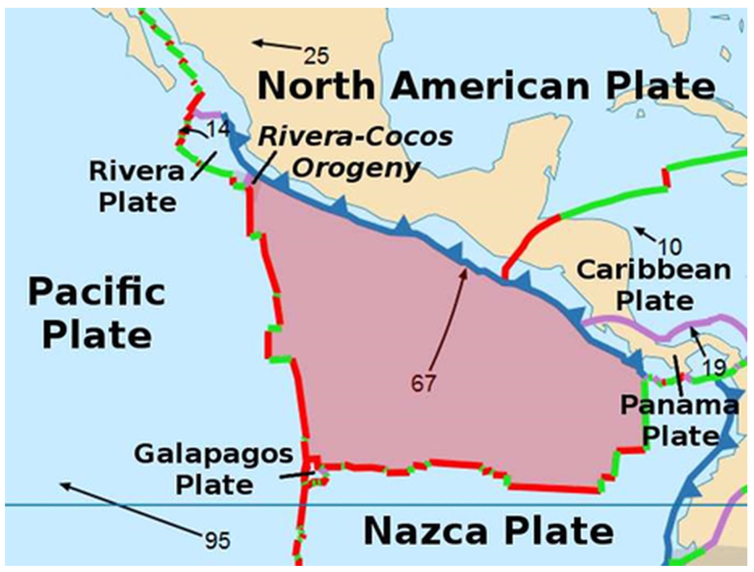
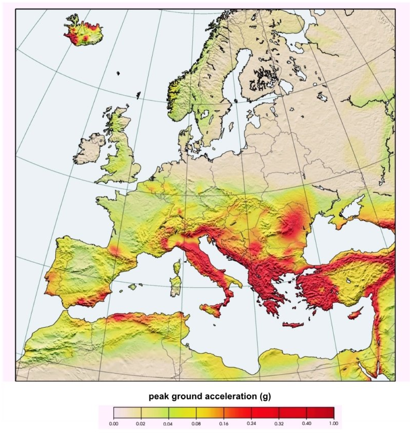
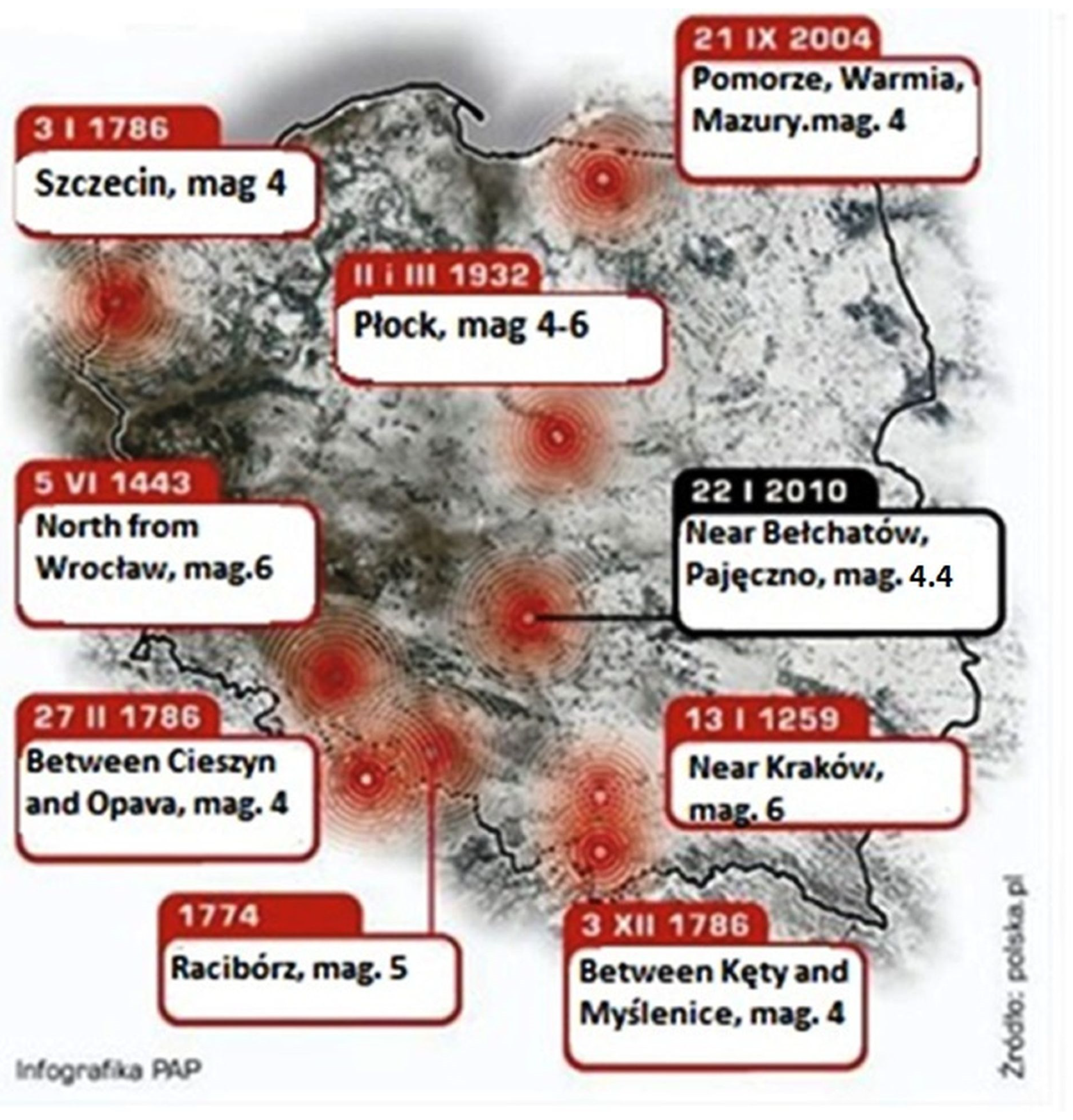
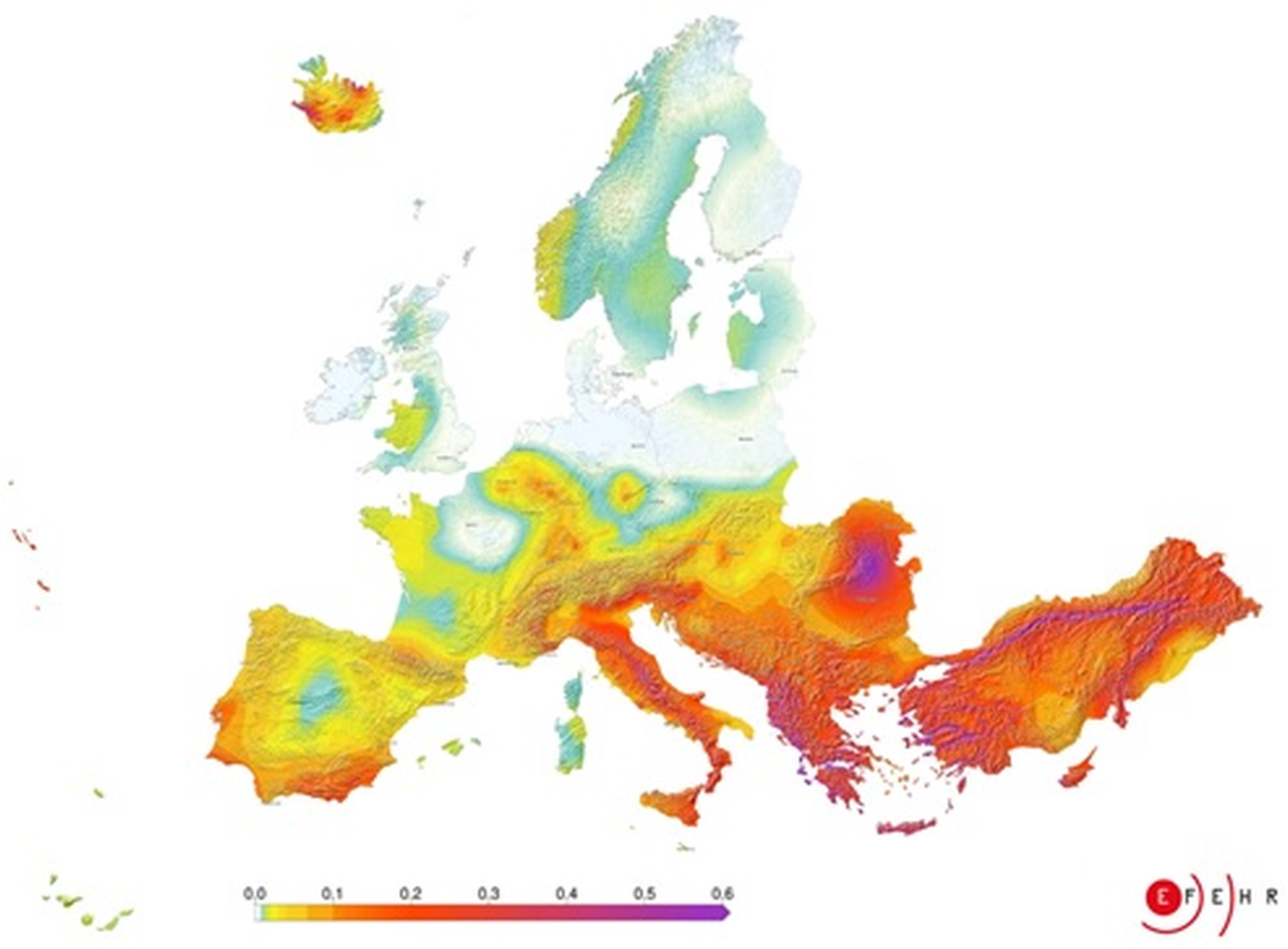
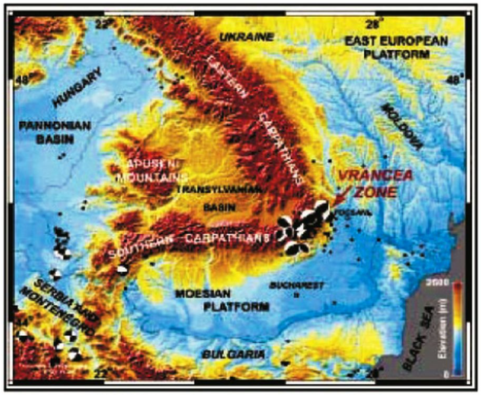
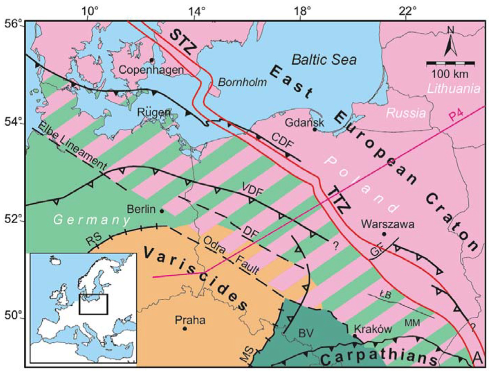
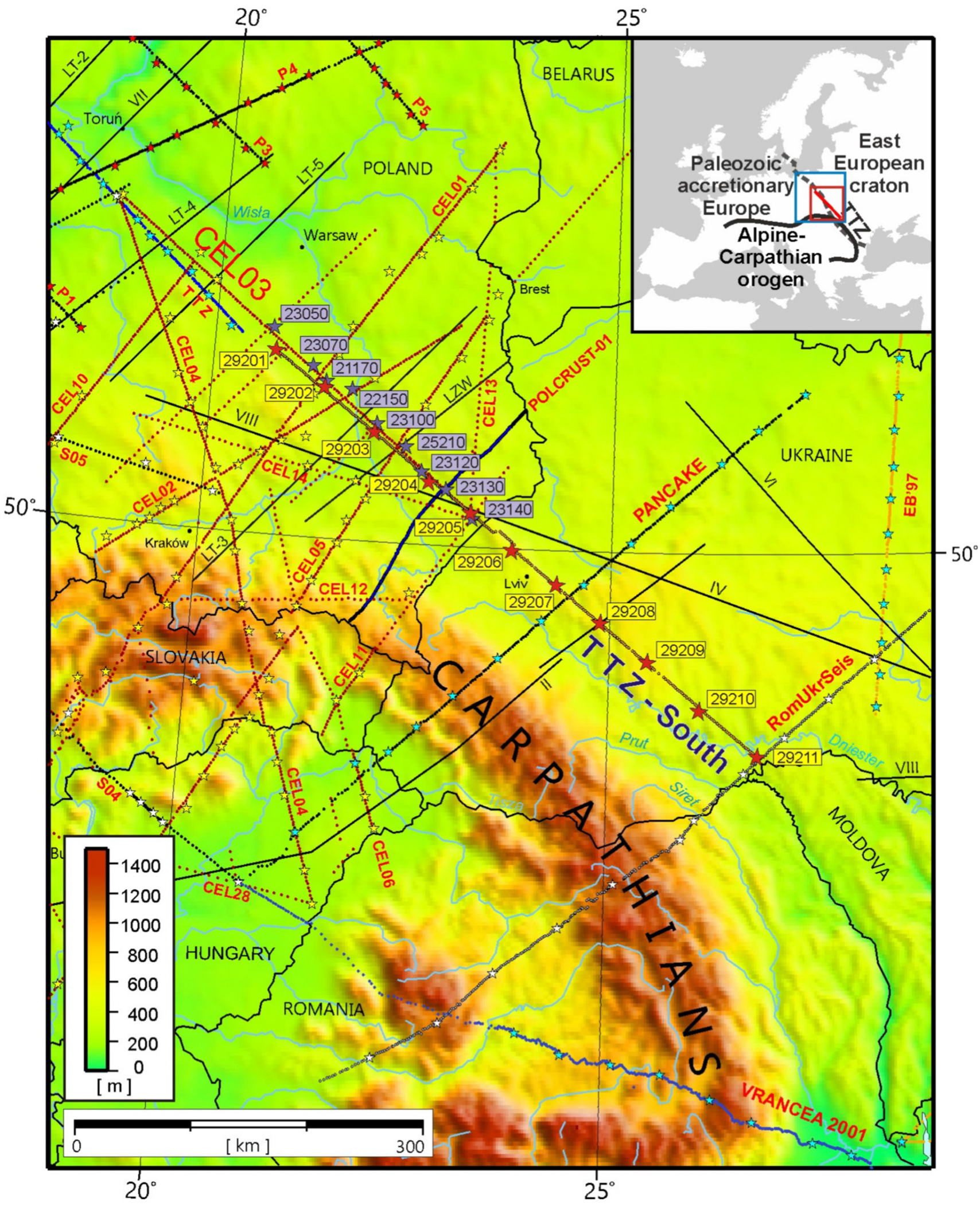
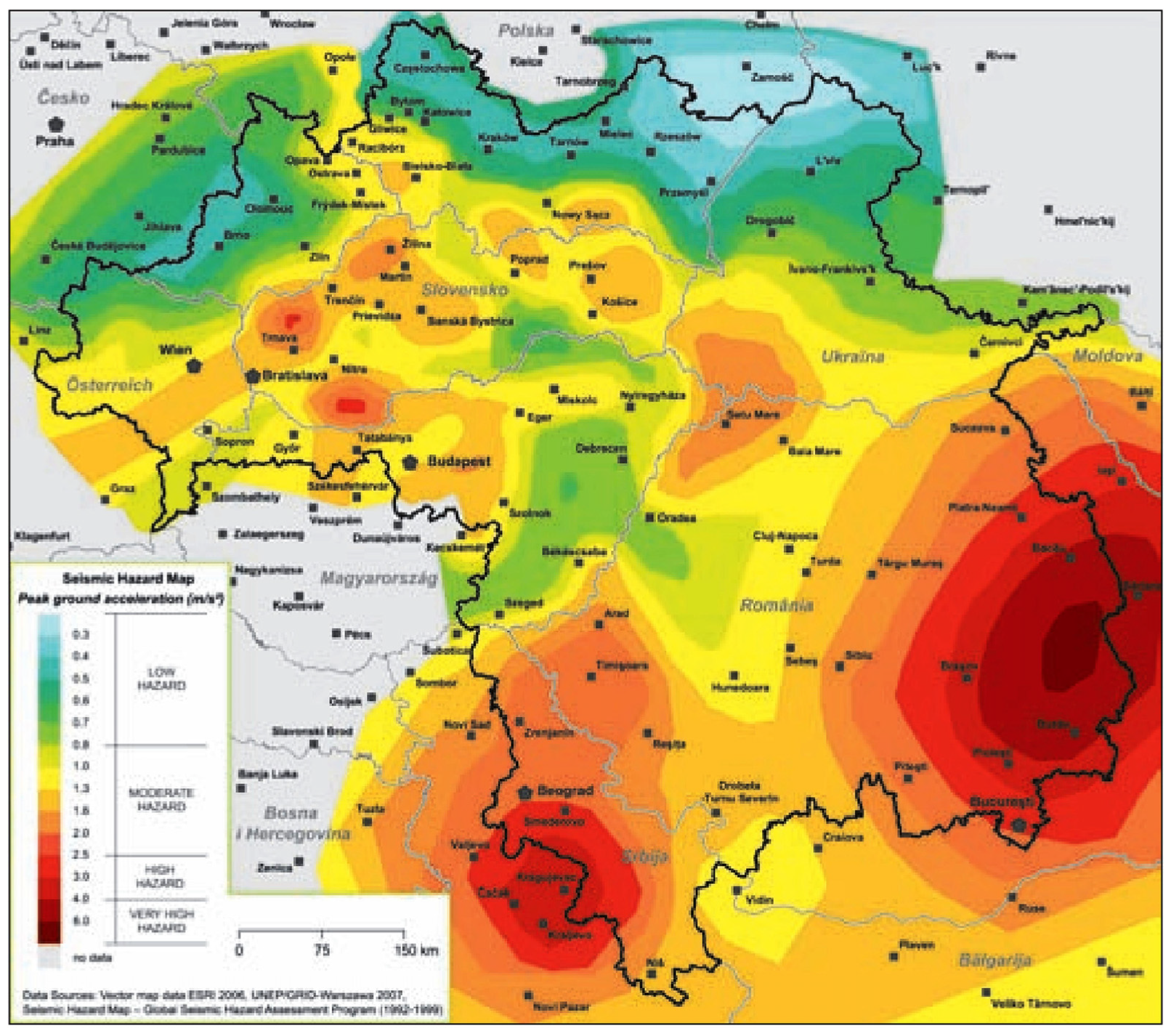
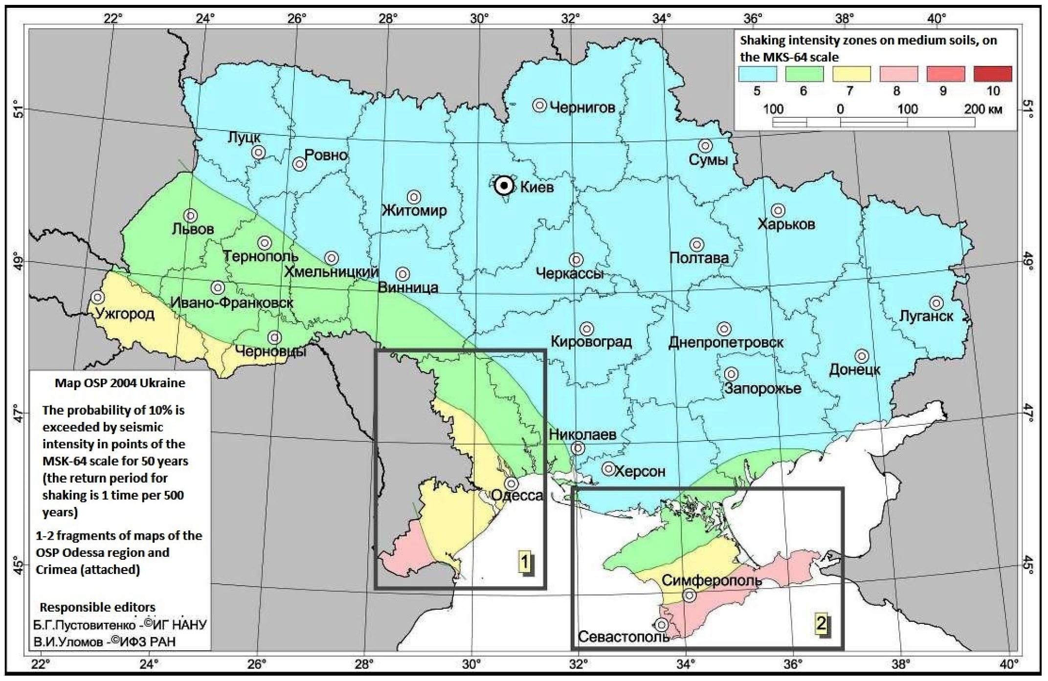
2. Risk of Earthquakes in Central Europe
3. Methodology
- −
- The seismic hazard is certainly not increasing. It is just that we are increasing our knowledge of fault systems, and as humans we have had a very short observation time compared to geological times, and therefore we have certainly missed several past events. We must consider the risk of earthquakes as part of the risk scenario for the socio-ecological system of the historical areas, namely: the built environment; the natural environment; the economic dimension; the social dimension; the cultural dimension (both tangible and intangible); and the political dimension, Table 1.
- −
- Exposure may be higher (e.g., densely populated areas; highly interdependent critical infrastructures) where the loss of one could lead to the loss of others (e.g., telecommunications); high-value and vulnerable industries (e.g., high technology).
- −
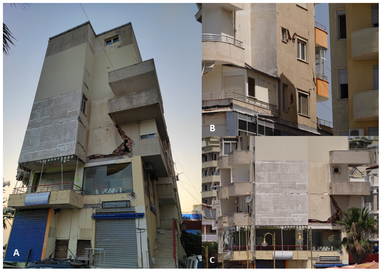
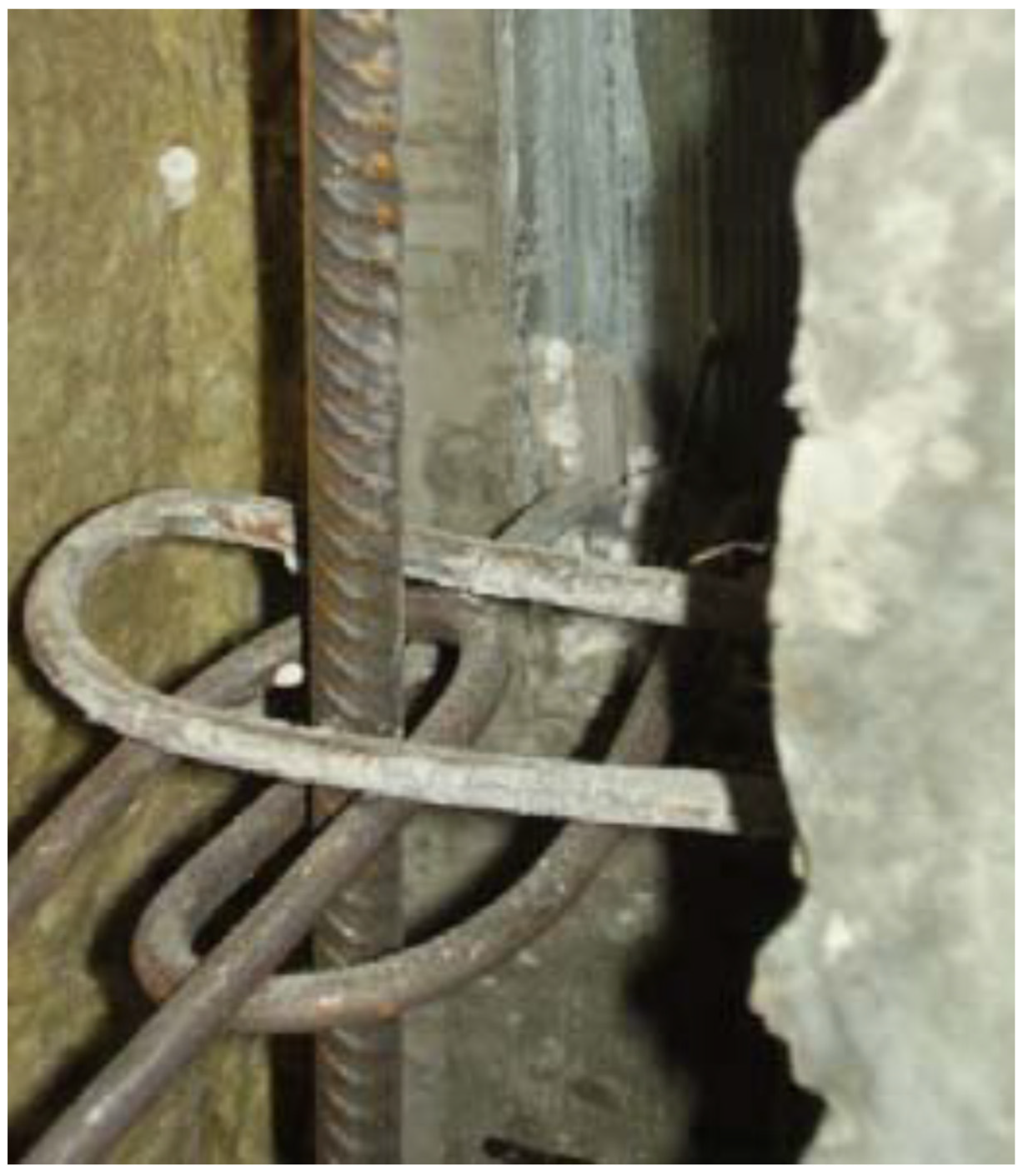
- The vulnerability of buildings and infrastructures may be high (because they were designed without consideration of seismic design codes) and may increase as buildings age and require structural retrofitting.
4. Results and Discussion
5. Conclusions
Funding
Institutional Review Board Statement
Informed Consent Statement
Data Availability Statement
Conflicts of Interest
References
- Dziennik Polski. Fala Wstrząsów Sejsmicznych w Europie, Katast, Rofalne Trzęsienie Ziemi w Rumunii. 6. Dziennik Polski. nr 52 (7 III) (7 March 1977) = nr 10225. 1977. Available online: http://mbc.malopolska.pl/dlibra/applet?mimetype=image/x.djvu&sec=false&handler=djvu_html5&content_url=/Content/61285/index.djvu (accessed on 14 August 2023).
- Wegener, A. Die Entstehung der Kontinente und Ozeane; Druck und Verlag von Friedr. Vieweg & Sohn r: Braunschweig, Germany, 1929; p. 18. [Google Scholar]
- Shearer, P.M. Introduction to Seismology; Cambridge University Press: Cambridge, UK, 1999; ISBN 0521-66953-7. [Google Scholar]
- Lovett, R.A. Europe Starting to Dive Under Africa? National Geographic News. 19 April 2011. Available online: http://news.nationalgeographic.com/news/2011/04/110419-europe-africa-mediterranean-earthquake-risk-increasing-earth-science/ (accessed on 30 November 2015).
- Bird, P. An Updated Digital Model of Plate Boundaries. Geochem. Geophys. Geosyst. 2003, 4, 1–52. [Google Scholar] [CrossRef]
- Baes, M.; Govers, R.; Wortel, R. Subduction initiation along the inherited weakness zone at the edge of a slab: Insights from numerical models. Geophys. J. Int. 2011, 184, 991–1008. [Google Scholar] [CrossRef]
- Zembaty, Z.; Wiejacz, P. Is there a need for seismic code in Poland? Wydawnictwo Politechniki Krakowskiej im. Tadeusza Kościuszki. Czasopismo Techniczne. Budownictwo, 2007; R. 104, z. 2-B, pp. 127–134. Available online: https://repozytorium.biblos.pk.edu.pl/redo/resources/34687/file/suwFiles/ZembatyZ_PolscePotrzebna.pdf (accessed on 14 August 2023).
- Trzęsienia Ziemi na Ziemiach Polskich. Available online: https://pl.wikipedia.org/wiki/Trz%C4%99sienia_ziemi_na_ziemiach_polskich (accessed on 30 November 2021).
- Leboussi, C. Des Séismes sans Précédent Historique Sont Possibles en Europe. LE MONDE. 16 August 2013. Available online: http://www.lemonde.fr/planete/article/2013/08/16/des-seismes-sans-precedent-historique-sont-possibles-en-europe_3462489_3244.html?xtmc=vibrations_du_sol&xtcr=2 (accessed on 30 November 2015).
- Lay, T.; Kanamori, H.; Ammon, C.; Nettles, M.; Ward, S.; Aster, R.; Beck, S.; Bilek, S.; Brudzinski, M.; Butler, R.; et al. The Great Sumatra-Andaman Earthquake of 26 December 2004. Science 2005, 308, 1127–1133. [Google Scholar] [CrossRef] [PubMed]
- USGS: US Geological Survey. Magnitude 9.1–Off the West Coast of Northern Sumatra. 26 December 2004. Available online: https://earthquake.usgs.gov/earthquakes/eventpage/official20041226005853450_30/executive (accessed on 14 August 2023).
- Pogoda, T. Potężne Trzęsienia Ziemi w Polsce Rujnowały Całe Miasta. Available online: http://www.twojapogoda.pl/wiadomosci/114040,potezne-trzesienia-ziemi-w-polsce-rujnowaly-cale-miasta (accessed on 30 November 2015).
- Giggenbach, W.; Sano, Y.; Schmincke, H. CO2-rich gases from Lakes Nyos and Monoun, Cameroon; Laacher See, Germany; Dieng, Indo-nesia, and Mt. Gambier, Australia—Variations on a common theme. J. Volcanol. Geotherm. Res. 1991, 45, 311–323. [Google Scholar] [CrossRef]
- Gal, F.; Michel, B.; Gilles, B.; Frédéric, J.; Karine, M. CO2 escapes in the Laacher See region, East Eifel, Germany: Application of natural analogue onshore and offshore geochemical monitoring, Of shore geochemical monitoring. Int. J. Greenh. Gas Control 2011, 5, 1099–1118. [Google Scholar] [CrossRef]
- GFZ: (Helmholtz-Zentrum Potsdam-Deutsches GeoForschungsZentrum) GFZ: Earthquake Info: Origin TimeUTC 2015-02-03 05:56:30, Mag 4.5, Latitude Degrees 50.65°N, Longitude Degrees 34.22°E, Depth km 10, Alert Classification Criteria M, Flinn-Engdahl Region Name Ukraine. 2015. Available online: https://geofon.gfz-potsdam.de/eqinfo/event.php?id=gfz2015citj (accessed on 30 April 2023).
- Vervaeck, A. Slightly Damaging Earthquake in Ukraine, 3 February, 2015 at 5:38 pm. Available online: http://earthquake-report.com/2015/02/03/moderate-earthquake-balticsbelarusnorthwestern-russia-reg-on-february-3-2015/ (accessed on 30 November 2015).
- Miyamoto, H.K.; Gilani, A.S.J.; Wong, K. Massive Damage Assessment Program and Repair and Reconstruction Strategy in the Aftermath of the 2010 Haiti Earthquake. Earthq. Spectra 2011, 27, 219–237. [Google Scholar] [CrossRef]
- Bye, B.L. Volcanic Eruptions: Science and Risk Management; Science 20.com: Folsom, CA, USA, 2011; Available online: https://www.science20.com/planetbye/volcanic_eruptions_science_and_risk_management-79456 (accessed on 14 August 2023).
- Carlsen, H.K.; Hauksdottir, A.; Valdimarsdottir, U.A.; Gíslason, T.; Einarsdottir, G.; Runolfsson, H.; Briem, H.; Finnbjornsdottir, R.G.; Gudmundsson, S.; Kolbeinsson, T.B.; et al. Health effects following the Eyjafjallajökull volcanic eruption: A cohort study. BMJ Open 2012, 2, e001851. [Google Scholar] [CrossRef] [PubMed]
- Dunphy Mark: Nabro Volcano Eruption Resumes. TesfaNews. 1 July 2011. Available online: https://www.tesfanews.net/nabro-volcano-eruption-resumes/ (accessed on 30 November 2015).
- The Netherlands Could Experience 7.0M Earthquake, Soon Netherlands Is Earthquake Waiting, 10-9-11. Available online: https://www.ad.nl/ad/nl/1012/Binnenland/article/detail/2901358/2011/09/10/Nederland-staat-zware-aardbeving-te-wachten.dhtml (accessed on 30 November 2015).
- A Hot New Island Has Just Surfaced in the Red Sea. What’s Going On? Smithsonian Scientists Explain. Earth Science, Marine Science, Science & Nature. 11 January 2012. Available online: https://insider.si.edu/2012/01/a-hot-new-island-has-just-popped-up-in-the-red-sea-what-is-going-on-smithsonian-scientists-explain/ (accessed on 30 November 2015).
- Wiens, D.A.; Stein, S.; Demets, C.; Gordon, R.G.; Stein, C. Plate tectonic models for Indian Ocean “intraplate” deformation. Tectonophysics 1986, 132, 37–48. [Google Scholar] [CrossRef]
- Shen, H. Unusual Indian Ocean Earthquakes Hint at Tectonic Breakup; April 2012 Quakes Occurred Away from Plate Edges, Suggesting Formation of a New Boundary; Nature Publishing Group: Berlin, Germany, 2012; Available online: https://www.nature.com/news/unusual-indian-ocean-earthquakes-hint-at-tectonic-breakup-1.11487 (accessed on 30 November 2015).
- Kington, T. Volcanic ‘Geyser’ Erupts Close to Rome Airport, Fiumicino. The Telegraph. 25 August 2013. Available online: https://www.telegraph.co.uk/news/worldnews/europe/italy/10265372/Volcanic-geyser-erupts-close-to-Rome-airport.html (accessed on 30 November 2015).
- Calder, S.; Italy Earthquakes: Why the Country Gets So Many of Them, and How To Survive One. The Independent, 20 January 2017. Available online: https://www.independent.co.uk (accessed on 30 April 2017).
- Andrews, R.G. Robin George Andrews: Quake Split a Tectonic Plate in Two, and Geologists are Shaken, An Intense Temblor in Mexico Was Just the Latest Example of an Enigmatic Type of Earthquake with Highly Destructive Potentia. National Geographic. 24 October 2018. Available online: https://www.nationalgeographic.com/science/2018/10/news-tectonic-plate-split-earthquakes-tsunamis-geology/ (accessed on 30 November 2018).
- Dapcevich, M. Mexico’s Huge 2017 Earthquake Split a Tectonic Plate in Two, Baffling Geologists, 25 October 2018, 12:11. Available online: https://www.iflscience.com/environment/mexicos-huge-2017-earthquake-split-a-tectonic-plate-in-two-baffling-geologists/ (accessed on 30 November 2018).
- Vila Janula: Shuarja e 51 Jetëve, orët e Ankthit dhe Shpresa për t’i Gjetur Gjallë, Historitë Tronditëse të 26 Nëntorit, Lëkundjet që Shuan Shumë Ëndërra (alb.). dosja.al, 2019-12-29 29 Dhjetor, 2019 14:00. Available online: https://dosja.al/dosja-termeti-shuarja-e-51-jeteve-oret-e-ankthit-dhe-shpresa-per-ti-gjetur-gjalle-historite-tronditese-te-26-nentorit-lekundjet-qe-shuan-shume-enderra/ (accessed on 30 November 2020).
- Wolniewicz, Ł. Email from, 7 September 2021, 09:29, with Agreement for Free Publishing. email accessed on 7 September 2021.
- University of Zagreb, 2020: Potresi Kod Petrinje u Razdoblju od 28.12.2020. u 06:28 do 31.12.2020. u 17:00 [Earthquakes Near Petrinja in the Period between 2020-12-28 06:28 and 2020-12-31 17:00]. Seismological Survey of Croatia, Faculty of Science, University of Zagreb. 31 December 2020. Available online: https://www.pmf.unizg.hr/geof/seizmoloska_sluzba/izvjesca_o_potresima?@=1m69w (accessed on 7 September 2021). (In Croatian).
- EMSC: (European-Mediterranean Seismological Centre (EMSC). Available online: http://www.emsc-csem.org/Earthquake/earthquake.php?id=425578 (accessed on 31 March 2023).
- PAP. Naukowcy: Polsce nie Grożą Silne Trzęsienia Ziemi, 25 January 2010. Available online: https://naukawpolsce.pap.pl/aktualnosci/news,369665,naukowcy-polsce-nie-groza-silne-trzesienia-ziemi.html (accessed on 30 November 2015).
- Giardini, D.; Grünthal, G.; Shedlock, K.M.; Zhang, P. The GSHAP Global Seismic Hazard Map. In International Handbook of Earthquake & Engineering Seismology; International Geophysics Series 81 B; Lee, W., Kanamori, H., Jennings, P., Kisslinger, C., Eds.; Academic Press: Amsterdam, The Netherlands, 2003; pp. 1233–1239. [Google Scholar]
- Niedźwiecki, M. Struktura Ziemi, Astronet.pl. Opublikowany: 2008-10-9 14:45, adk.astronet.pl/images/Plates_tect.jpg. 2008, accessed on 30 November 2015.
- GEM: GEM Foundation: Leveraging on Unique Synergies and Findings in Europe. 2013. Available online: https://www.globalquakemodel.org/what/regions/europe/ (accessed on 30 November 2015).
- SHARE: Seismic Hazard Harmonization in Europe, European Seismic Hazard Map 2013. Available online: https://www.share-eu.org/sites/default/files/Figure1.mean_SA%5B000%5D_RP475_arranged_550_360.png (accessed on 30 November 2015).
- Danciu, L.; Nandan, S.; Reyes, C.; Basili, R.; Weatherill, G.; Beauval, C.; Rovida, A.; Vilanova, S.; Sesetyan, K.; Bard, P.-Y.; et al. The 2020 Update of the European Seismic Hazard Model: Model Overview. EFEHR Technical Report 001, v1.0.0. Available online: http://hazard.efehr.org/en/Documentation/specific-hazard-models/europe/eshm2020-overview/ (accessed on 14 August 2023).
- Basili, R.; Kastelic, V.; Demircioglu, M.B.; Garcia Moreno, D.; Nemser, E.S.; Petricca, P.; Sboras, S.P.; Besana-Ostman, G.M.; Cabral, J.; Camelbeeck, T.; et al. The European Database of Seismogenic Faults (EDSF) Compiled in the Framework of the Project SHARE. Available online: https://seismofaults.eu/edsf13 (accessed on 31 March 2023).
- efehr.org: EARTHQUAKE RISK across Europe. What Effects Should We Expect from Future Earthquakes in Europe? The efehr.org Website Is Maintained and Hosted by the Swiss Seismological Service (SED) at ETH Zurich, in Collaboration with GEM (Global Earthquake Model Foundation) and EPOS (European Plate Observing System). Available online: http://www.efehr.org/explore/Downloads-information-material/ (accessed on 30 November 2015).
- Ardeleanu, L.; Leydecker, G.; Bonjer, K.-P.; Busche, H.; Kaiser, D.; Schmitt, T. Probabilistic seismic hazard map for Romania as a basis for a new building code. Nat. Hazards Earth Syst. Sci. 2005, 5, 679–684. [Google Scholar] [CrossRef]
- Oth, A.; Wenzel, F.; Radulian, M. Source parameters of intermediate-depth Vrancea (Romania) earthquakes from empirical Green’s functions modelling. Tectonophysics 2007, 438, 33–56. [Google Scholar] [CrossRef]
- Mitrofan, H.; Anghelache, M.-A.; Chitea, F.; Damian, A.; Cadicheanu, N.; Vişan, M. Lateral detachment in progress within the Vrancea slab (Romania): Inferences from intermediate-depth seismicity pat-terns. Geophys. J. Int. 2016, 205, 864–875. [Google Scholar] [CrossRef]
- Zoran, M.A.; Savastru, R.S.; Savastru, D.M. Savastru: Satellite thermal infrared anomalies associated with strong earthquakes in the Vrancea area of Romania. Open Geosci. 2015, 7, 606–617. [Google Scholar] [CrossRef]
- Janik, T.; Starostenko, V.; Aleksandrowski, P.; Yegorova, T.; Czuba, W.; Środa, P.; Murovskaya, A.; Zayats, K.; Mechie, J.; Kolomiyets, K.; et al. Lithospheric Structure of the East European Craton at the Transition from Sarmatia to Fennoscandia Interpreted from the TTZ-South Seismic Profile (SE Poland to Ukraine). Minerals 2022, 12, 112. [Google Scholar] [CrossRef]
- Grad, M.; Guterch, A.; Mazur, S. Seismic Refraction Evidence for Crustal Structure in Central Part of the Trans-European Suture Zone in Poland; Winchester, J.A., Pharoah, T.C., Verniers, J., Eds.; Paleozoic Amalgamation of Central Europe; Geological Society of London Special Publication: London, UK, 2022; Volume 201, pp. 295–309. [Google Scholar]
- Ptáček, P.; Létal, A.; Ruffini, F.V.; Renner, K. Atlas of the Carpathian Macroregion. Eur. Reg. 2009, 17, 108–122. [Google Scholar]
- Nemchynov, I.; Kryvosheyev, P.; Khavkin, A.; Maryenkov, N.; Babik, K.; Dorofyeyev, V.; Yegupov, K.; Murashko, A.; Zolotaryov, I.; Kukunayev, V.; et al. Seismic Hazards in Ukraine, Investigation Experience and Earthquake Engineering Development Tasks. In Proceedings of the 15th World Conference on Earthquake Engineering Conference Venue: Proceedings of the 15th World Conference on Earthquake Engineering, Lisbon, Portugal, 24–28 November 2012. [Google Scholar]
- PGI: The Polish Geological Institute-National Research Institute. (Pol) Państwowy Instytut Geologiczny-Państwowy Instytut Badawczy, Marek Jarosiński i Mirosław Rutkowski: Trzęsienie ziemi w Żerkowie, 09 stycznia 2012. Available online: https://www.pgi.gov.pl/instytut-geologiczny-aktualnosci-informacje/4032-trzesienie-ziemi-w-zerkowie (accessed on 30 November 2015).
- The ARCH Risk Scenario Toolbox. Available online: https://websites.fraunhofer.de/arch/arch-risk-scenario-toolbox/ (accessed on 30 March 2023).
- GEM: Countryprofiles. POLAND, Version 1.2, 1 March 2019. Available online: https://downloads.openquake.org/countryprofiles/POL.pdf (accessed on 30 March 2023).
- Mazur, S.; Aleksandrowski, P.; Turniak, K.; Krzemiński, L.; Mastalerz, K.; Górecka-Nowak, A.; Kurowski, L.; Krzywiec, P.; Żelaźniewicz, A.; Fanning, M.C. Uplift and late orogenic deformation of the Central European Variscan belt as revealed by sediment provenance and structural record in the Carboniferous foreland basin of western Poland. Int. J. Earth Sci. 2008, 99, 47–64. [Google Scholar] [CrossRef]
- Seed, H.B.; Schnabel, P.B. Soil and Geological Effects on Site Response During Earthquakes. In Proceedings of the First International Conference on Microzonation for Safer Construction, Research and Application, Seattle, WA, USA, 30 October–3 November 1972; Volume I; pp. 61–74. [Google Scholar]
- Mihalić Arbanas, S.; Oštrić, M.; Krka, M. Seismic microzonation: A review of principles and practice. Geofizika 2011, 28, 5–20. [Google Scholar]
- Jędrzejczyk, Z.; Skrzypek, J.; Kukuła, K.; Walkosz, A. Badania Operacyjne w Przykładach i Zadaniach; Państwowe Wydawnictwo Naukowe: Warszawa, Poland, 2002. [Google Scholar]
- Webster, I. CPI Inflation Calculator. Available online: https://www.in2013dollars.com/ (accessed on 30 March 2023).
- CoinMill.com-Kalkulator Walutowy. Available online: https://pl.coinmill.com/PLN_USD.html (accessed on 30 March 2023).
- California Institute of Technology (Caltech). Southern California Seismic Network. International Federation of Digital Seismograph Networks, Preparedness Applies, Twitter: Caltech Seismo Lab @CaltechSeismo, Earthquake #prepar-edness. 1926. Available online: https://twitter.com/CaltechSeismo/status/1560657843774259209 (accessed on 19 August 2022).
- Surdel, T. Jak Chile Uniknęło Tysięcy Ofiar. Gazeta Wyborcza, 4 March 2010. [Google Scholar]


| HA Social-Ecological-Systems Dimensions | Natural Environment | Built Environment | Economic | Social | Cultural | |||||||||
|---|---|---|---|---|---|---|---|---|---|---|---|---|---|---|
| Exposed elements within the HA’s SES dimensions | Water resources | Terrestrial and coastal ecosystems | Soil | Critical infrastructure | Historic city centre/urban environment | Buildings | Agriculture, Forestry livestock and fisheries | Tourism | Health and Security | Movable heritage | Archeological resources | Buildings & structure | Cultural landscapes | |
| HAZARDS | ||||||||||||||
| Precipitation | 1 | 1 | 4 | 5 | 5 | 4 | 4 | 3 | 3 | 3 | 5 | 5 | 4 | |
| Heatwaves, extreme day and night temperature | 4 | 1 | 4 | 3 | 3 | 3 | 4 | 2 | 5 | 2 | 4 | 5 | 5 | |
| RESULTS | ||||||||||||||
| Precipitation | 2.0 | 4.7 | 3.4 | 3.0 | 4.3 | 3.1 | ||||||||
| Heatwaves, extreme day and night temperature | 3.0 | 3.0 | 3.0 | 5.0 | 4.0 | 3.6 | ||||||||
| Grade 1 | Grade 2 | Grade 3 | |
|---|---|---|---|
| Ground motions | Historical earthquakes and existing information Geological maps Interviews with local residents | Microtremor Simplified geotechnical study | Geotechnical Investigation Ground response analysis |
| Slope Instability | Historical earthquakes and existing information Geological and geomorphological maps | Air photos and remote sensing Field studies Vegetation and precipitation data | Geotechnical investigation Analyses |
| Liquefaction | Historical earthquakes and existing information Geological and geomorphological maps | Air photos and remote sensing Field studies Interviews with local residents | Geotechnical investigation Analyses |
| Scale of mapping. | 1:1,000,000~1:50,000 | 1:100,000~1:10,000 | 1:25,000~1:5000 |
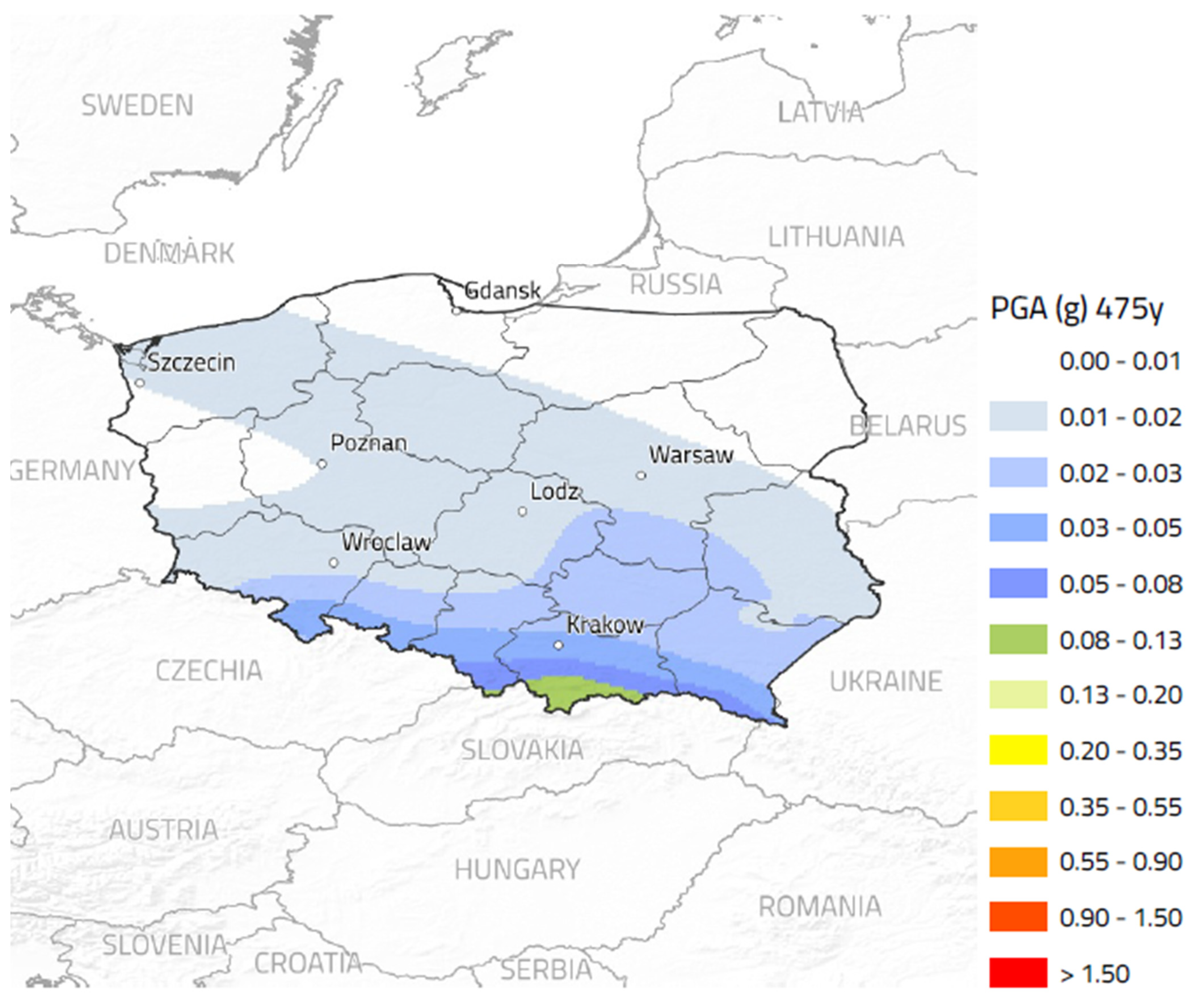
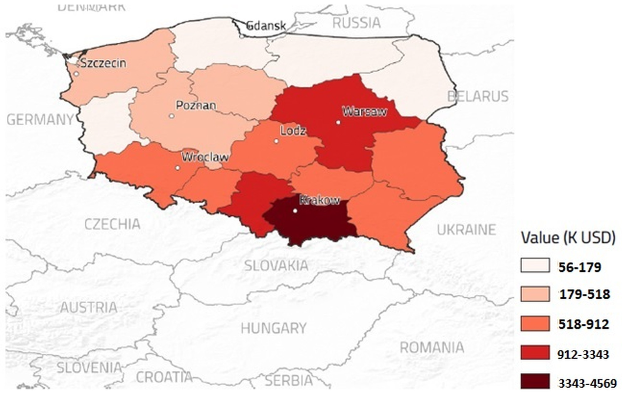
| Ratio (2019) [51] | Minimal Losses k$ (2019) [51] | Maximal Losses k$ (2019) [51] | Ratio (2023) | Minimal Losses k$ (2023) [57] | Maximal Losses k$ (2023) [57] | ||
|---|---|---|---|---|---|---|---|
| 1. Dolnośląskie | Lower Silesian Voivodeship | 0 | 518 | 912 | 0.02 | 610 | 1074 |
| 2. Kujawsko-Pomorskie | Warmian–Masurian Voivodeship | 0.01 | 179 | 518 | 0.01 | 212 | 610 |
| 3. Lubelskie | Lublin Voivodeship | 0 | 518 | 912 | 0.01 | 610 | 1074 |
| 4. Lubuskie | Lubusz Voivodeship | 0 | 56 | 179 | 0 | 66 | 212 |
| 5. Łódzkie | Łódź Voivodeship | 0 | 518 | 912 | 0.01 | 610 | 1074 |
| 6. Małopolskie | Lesser Poland Voivodeship | 0.03 | 3343 | 4569 | 0.05 | 3934 | 5376 |
| 7. Mazowieckie | Masovian Voivodeship | 0.01 | 912 | 3343 | 0.03 | 1074 | 3943 |
| 8. Opolskie | Opole Voivodeship | 0.01 | 518 | 912 | 0.03 | 610 | 1074 |
| 9. Podkarpackie | Subcarpathian Voivodeship | 0.01 | 518 | 912 | 0.03 | 610 | 1074 |
| 10. Podlaskie | Podlaskie Voivodeship | 0 | 56 | 179 | 0 | 66 | 212 |
| 11. Pomorskie | Pomeranian Voivodeship | 0 | 56 | 179 | 0 | 66 | 212 |
| 12. Śląskie | Upper Silesia | 0.02 | 912 | 3343 | 0.04 | 1074 | 3934 |
| 13. Świętokrzyskie | Holy Cross Voivodeship | 0.01 | 518 | 912 | 0.03 | 610 | 1074 |
| 14. Warmińsko-Mazurskie | Warmian–Masurian Voivodeship | 0 | 56 | 179 | 0 | 66 | 212 |
| 15. Wielkopolskie | Greater Poland Voivodeship | 0 | 179 | 518 | 0.01 | 212 | 610 |
| 16. Zachodniopomorskie | The West Pomeranian Voivodeship | 0 | 179 | 518 | 0.01 | 212 | 610 |
| Total k$ | 144.98 | 269.9 | 357.54 | 702.37 |
Disclaimer/Publisher’s Note: The statements, opinions and data contained in all publications are solely those of the individual author(s) and contributor(s) and not of MDPI and/or the editor(s). MDPI and/or the editor(s) disclaim responsibility for any injury to people or property resulting from any ideas, methods, instructions or products referred to in the content. |
© 2023 by the author. Licensee MDPI, Basel, Switzerland. This article is an open access article distributed under the terms and conditions of the Creative Commons Attribution (CC BY) license (https://creativecommons.org/licenses/by/4.0/).
Share and Cite
Lewandowski, K. Proposal for the Preparation of New Building Standards in Poland to Protect against Earthquakes in the Next 50 Years. Buildings 2023, 13, 2090. https://doi.org/10.3390/buildings13082090
Lewandowski K. Proposal for the Preparation of New Building Standards in Poland to Protect against Earthquakes in the Next 50 Years. Buildings. 2023; 13(8):2090. https://doi.org/10.3390/buildings13082090
Chicago/Turabian StyleLewandowski, Krzysztof. 2023. "Proposal for the Preparation of New Building Standards in Poland to Protect against Earthquakes in the Next 50 Years" Buildings 13, no. 8: 2090. https://doi.org/10.3390/buildings13082090
APA StyleLewandowski, K. (2023). Proposal for the Preparation of New Building Standards in Poland to Protect against Earthquakes in the Next 50 Years. Buildings, 13(8), 2090. https://doi.org/10.3390/buildings13082090