


Augmented Reality for Building Authorities: A Use Case Study in Austria


Abstract
1. Introduction
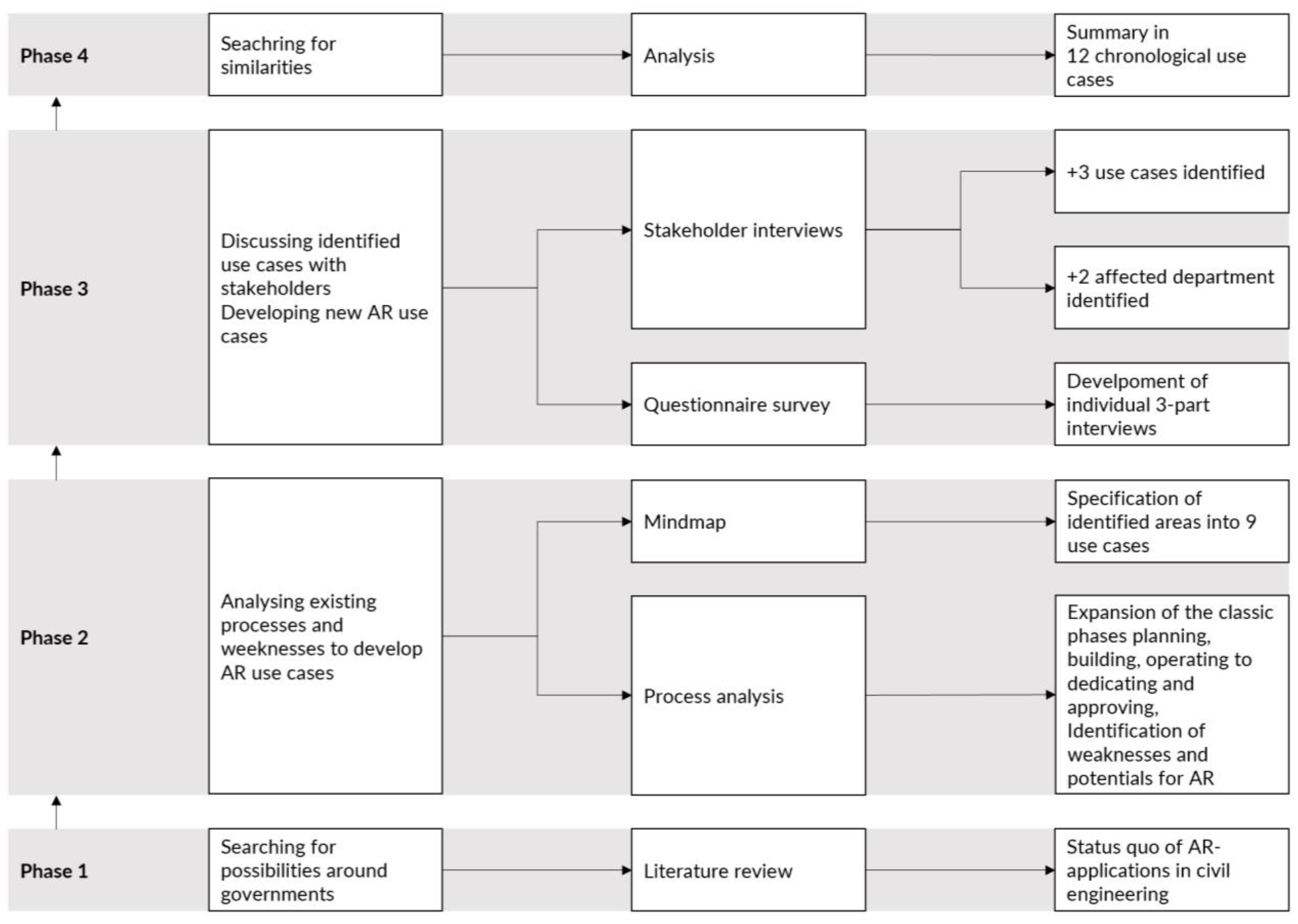
2. Methods
2.1. Phase 1—Literature Research
- Stakeholder engagement;
- Collaboration/communication/design support;
- Construction management/documentation/quality control;
- Safety management;
- Facility management/operations and management.
2.2. Phase 2—Process Analysis
- Identification of the participants;
- Identification of the processes;
- Identification of process weaknesses (points of contact).
2.3. Phase 3—Stakeholder Interviews
2.4. Phase 4—Analysis
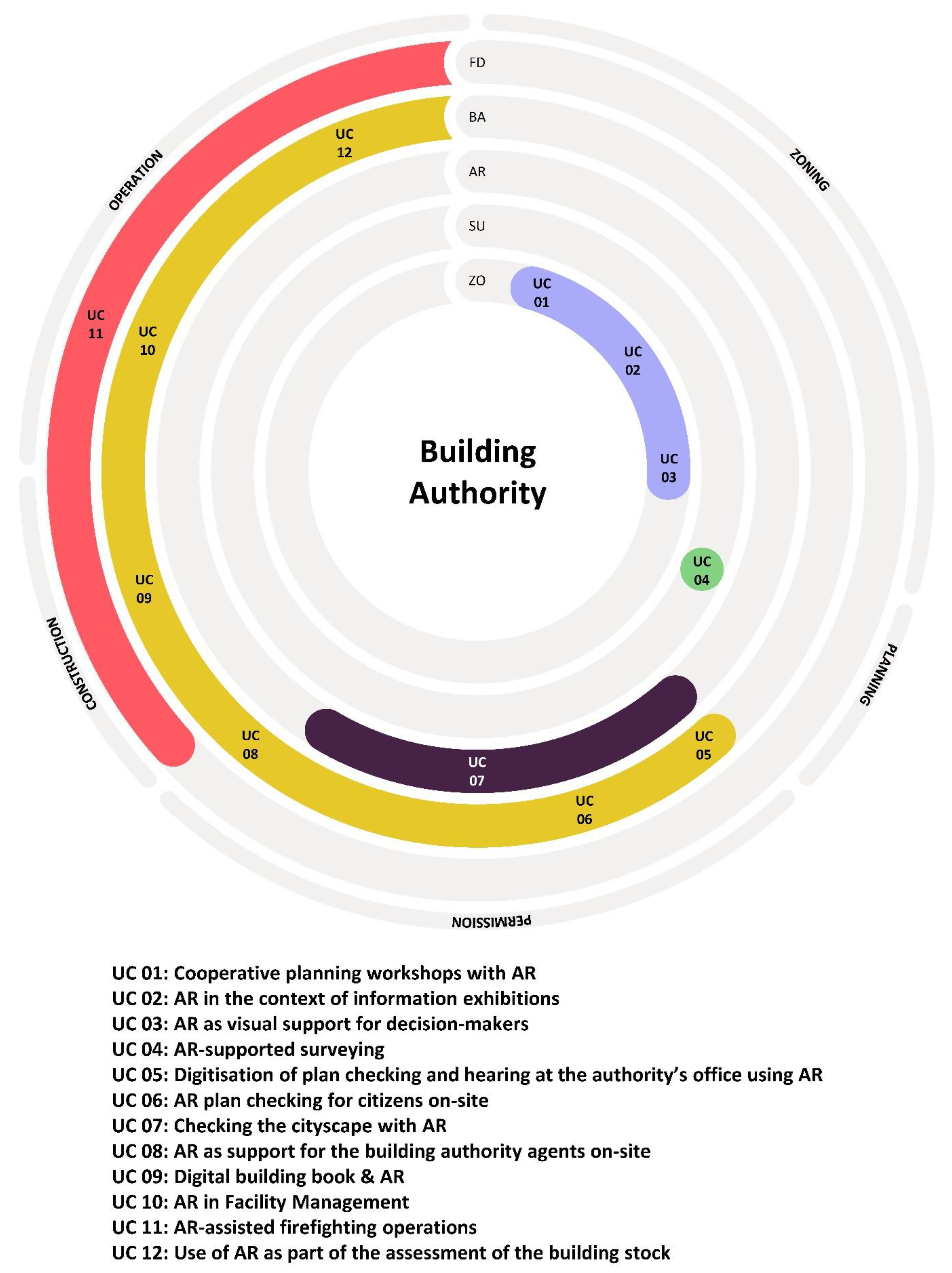
3. Use Cases
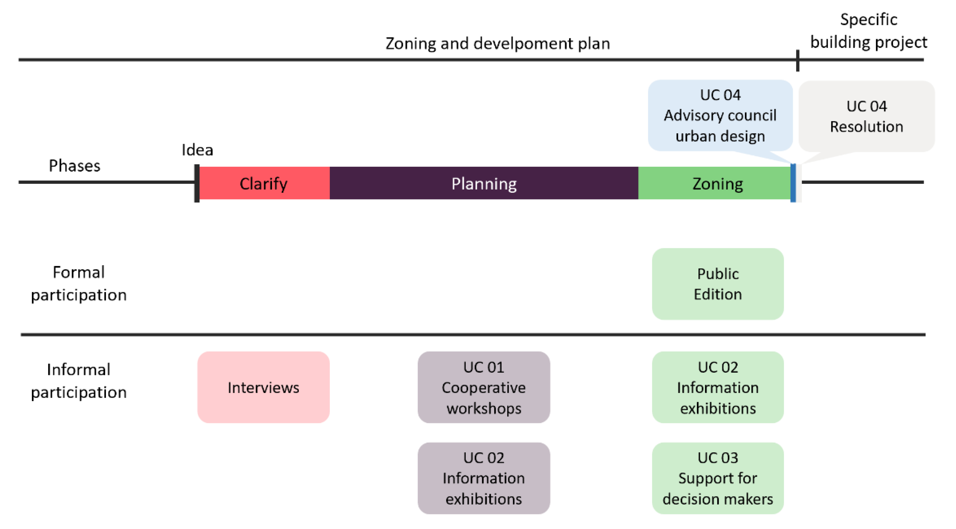
3.1. Zoning
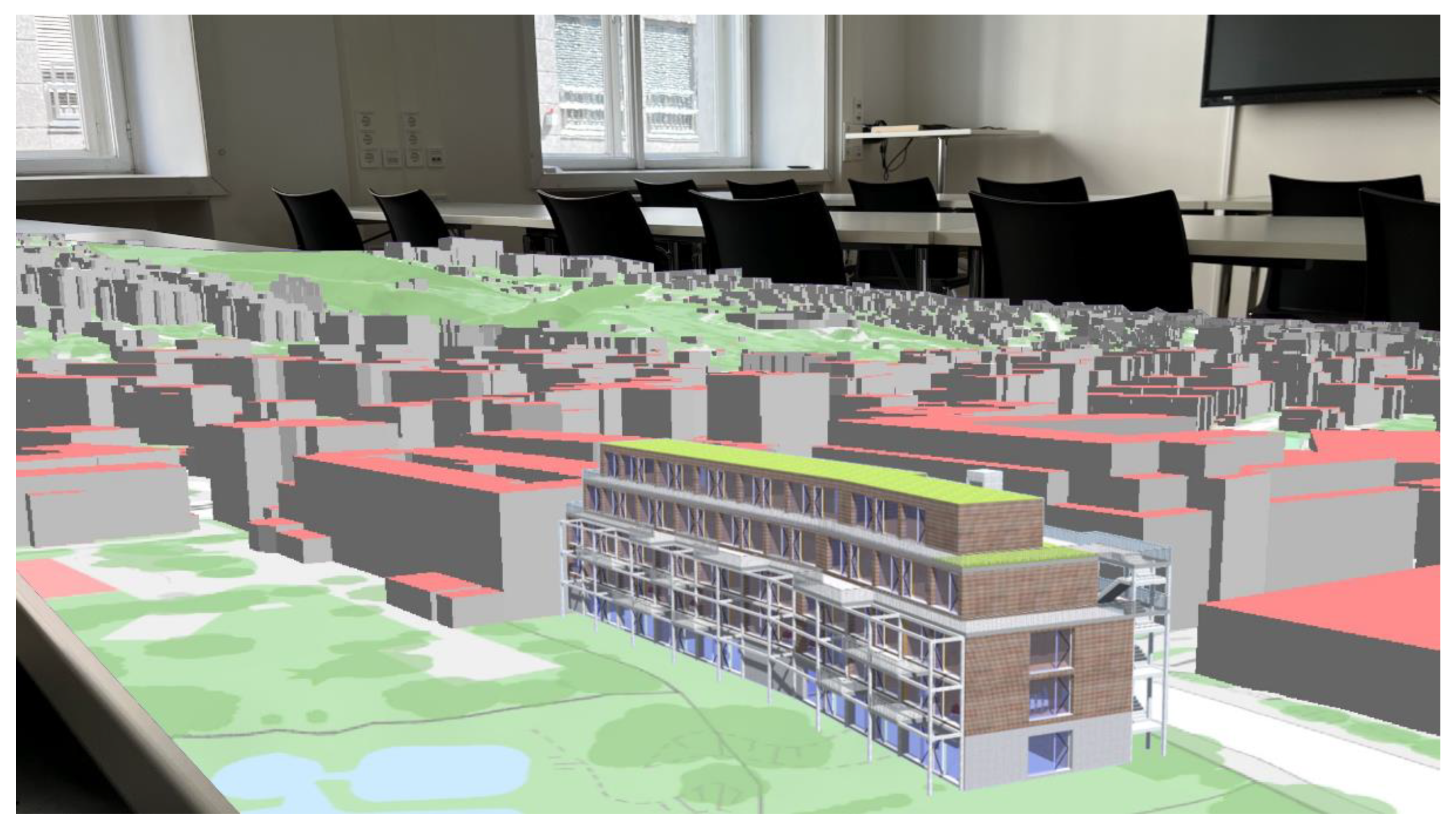
- UC 01: Cooperative planning workshops with AR
- UC 02: AR in the context of information exhibitions
- UC 03: AR as a visual support for decision-makers
3.2. Planning
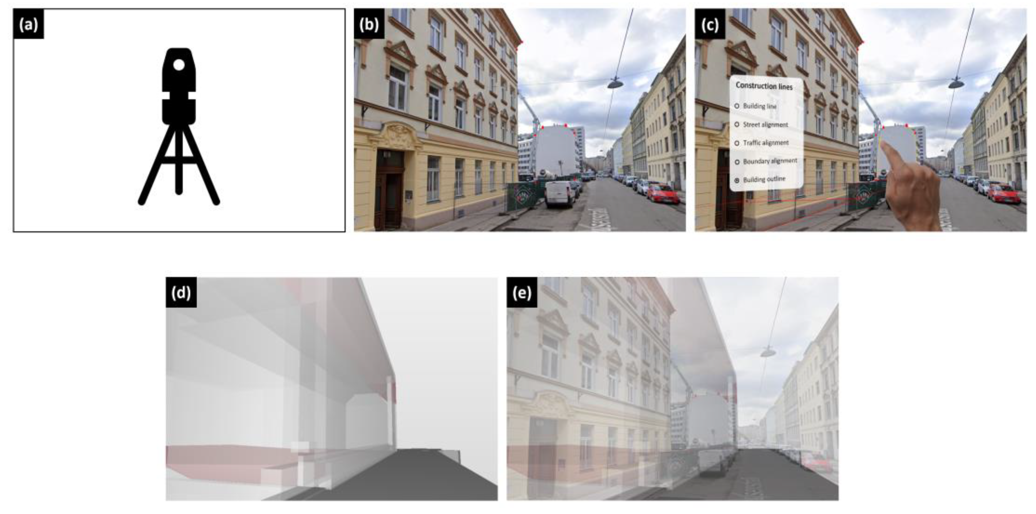
- UC 04: AR-supported surveying
3.3. Permission
- UC 05: Digitisation of plan checking and hearing at the authority’s office using AR
- UC 06: AR plan checking for citizens on-site
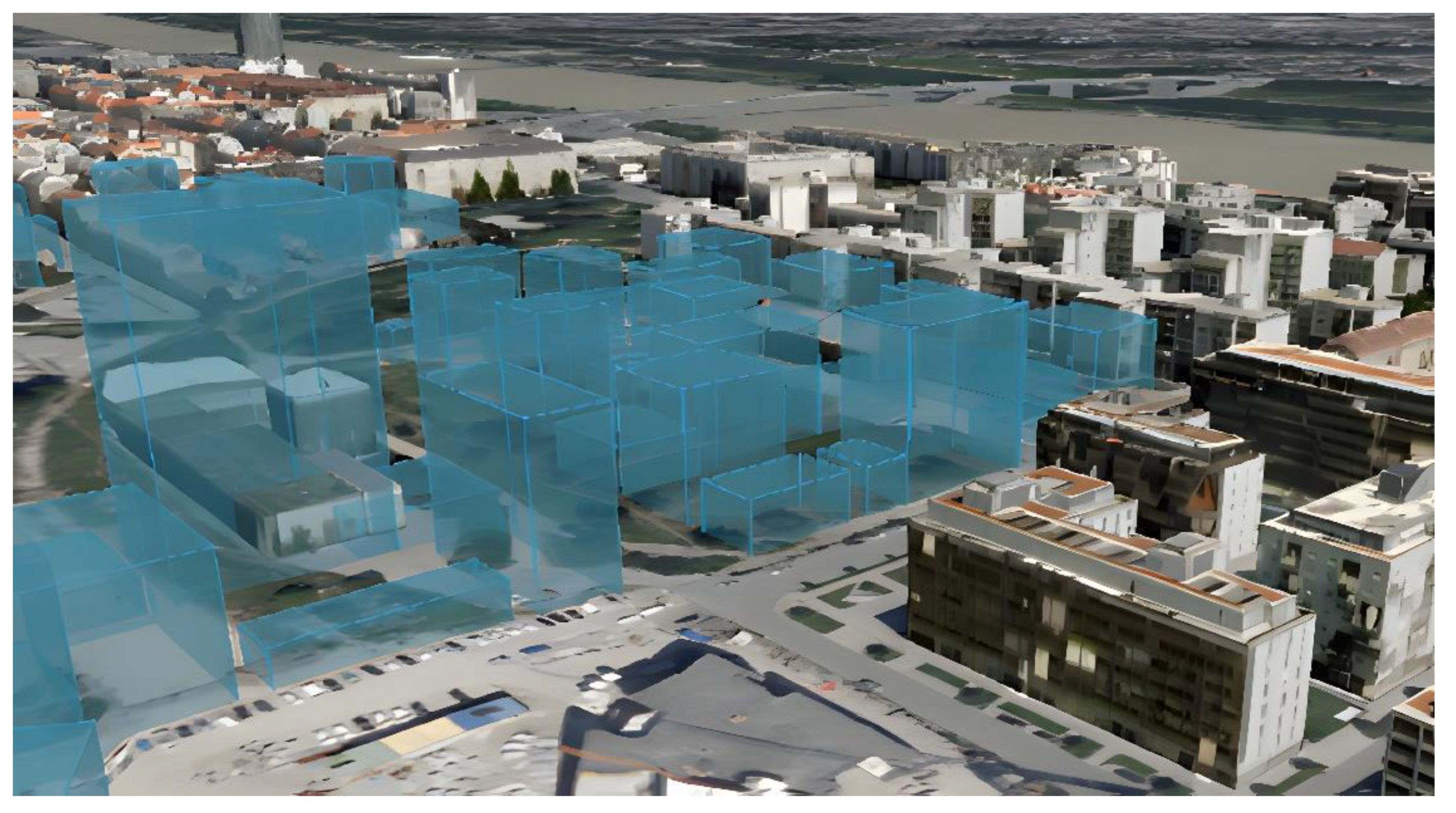
- UC 07: Checking the cityscape with AR
3.4. Construction
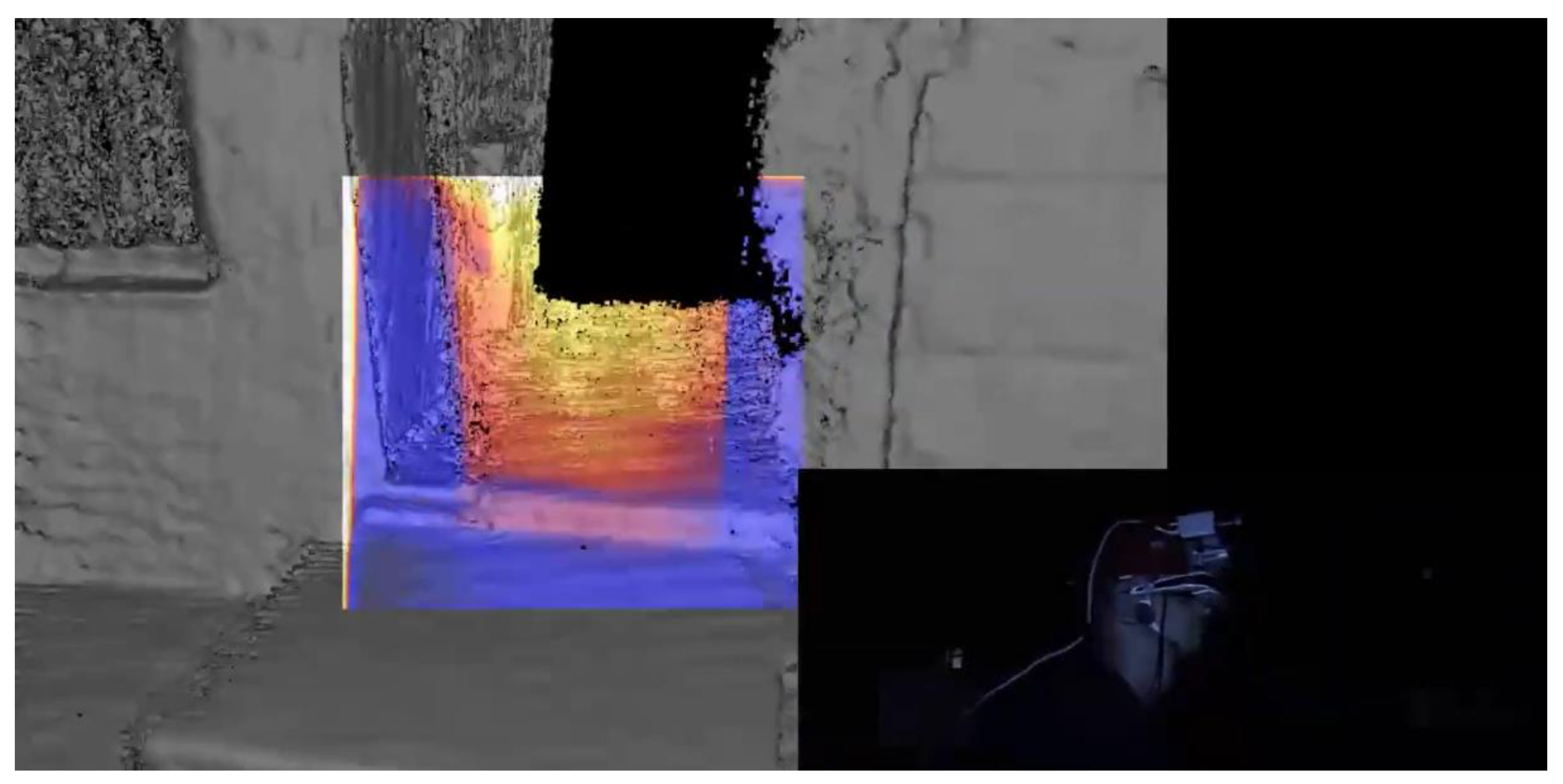
- UC 08: AR as support for the building authority agents on-site
3.5. Operation
- UC 09: Digital building books and AR
- The designation of the components that require regular inspection;
- The date of the initial inspection and future intervals;
- The results of the checks that are carried out.
- UC 10: AR in facility management
- FM managers need up to 20% of their working time to search for information (up to 70% savings potential);
- High time expenditure for mass determinations (up to 70% savings potential).
- UC 11: AR-assisted firefighting operations
- UC 12: Use of AR as part of the assessment of the building stock
4. Discussion
5. Conclusions
Author Contributions
Funding
Data Availability Statement
Acknowledgments
Conflicts of Interest
References
- Kovacic, I.; Oberwinter, L.; Filzmoser, M.; Kiesel, K. BIM Roadmap for Integrated Planning; Eigenverlag: Wien, Austria, 2014; ISBN 978-3-200-03825-7. [Google Scholar]
- Eichler, C.C.; Schranz, C.; Krischmann, T.; Urban, H. BIMcert Handbook—Basic Knowledge openBIM—Edition 2023; Mironde-Verlag: Niederfrohna, Germany, 2023; ISBN 978-3-96063-053-1. [Google Scholar]
- Urban, H.; Schranz, C. AR-AQ-Bau—Use of Augmented Reality for Acceptance and Quality Assurance on Construction Sites. Available online: https://nachhaltigwirtschaften.at/en/sdz/projects/ar-aq-bau.php (accessed on 1 June 2021).
- Schranz, C.; Gerger, A.; Urban, H. Augmented Reality im Bauwesen: Teil 1—Anwendungs- und Anforderungsanalyse. Bauingenieur 2020, 95, 379–388. [Google Scholar] [CrossRef]
- Bademosi, F.; Issa, R.R.A. Implementation of Augmented Reality throughout the Lifecycle of Construction Projects. In Advances in Informatics and Computing in Civil and Construction Engineering; Mutis, I., Hartmann, T., Eds.; Springer Nature: Cham, Switzerland, 2019; pp. 307–313. ISBN 978-3-030-00219-0. [Google Scholar]
- Urban, H.; Breitschopf, N.; Schranz, C. Entwicklung und Validierung eines AR-Abnahmetools für die Örtliche Bauaufsicht am Beispiel der Technischen Gebäudeausrüstung. Bauingenieur 2022, 97, 353–361. [Google Scholar] [CrossRef]
- Caixeta, M.; Bross, J.; Tzortzopoulos, P.; Fabricio, M. Value Generation through User Involvement in Healthcare Design. In Proceedings of the International Group for Lean Construction, Fortaleza, Brazil, 29 July–2 August 2013; pp. 299–308. [Google Scholar]
- Krischmann, T.; Urban, H.; Schranz, C. Entwicklung eines openBIM-Bewilligungsverfahrens. Bauingenieur 2020, 95, 335–344. [Google Scholar] [CrossRef]
- Meža, S.; Turk, Ž.; Dolenc, M. Measuring the Potential of Augmented Reality in Civil Engineering. Adv. Eng. Softw. 2015, 90, 1–10. [Google Scholar] [CrossRef]
- Braun, V.; Clarke, V. Using Thematic Analysis in Psychology. Qual. Res. Psychol. 2006, 3, 77–101. [Google Scholar] [CrossRef]
- Gerger, A.; Schranz, C.; Urban, H. Augmented-Reality-Use-Cases im Bauwesen: Potentiale und Anforderungen; TU Wien: Wien, Austria, 2019; 52p. [Google Scholar]
- Sidani, A.; Dinis, F.M.; Sanhudo, L.; Duarte, J.; Santos Baptista, J.; Poças Martins, J.; Soeiro, A. Recent Tools and Techniques of BIM-Based Virtual Reality: A Systematic Review. Arch. Computat. Methods Eng. 2021, 28, 449–462. [Google Scholar] [CrossRef]
- Davila Delgado, J.M.; Oyedele, L.; Demian, P.; Beach, T. A Research Agenda for Augmented and Virtual Reality in Architecture, Engineering and Construction. Adv. Eng. Inform. 2020, 45, 101122. [Google Scholar] [CrossRef]
- Rankohi, S.; Waugh, L. Review and Analysis of Augmented Reality Literature for Construction Industry. Vis. Eng. 2013, 1, 9. [Google Scholar] [CrossRef]
- Wang, X.; Kim, M.J.; Love, P.E.D.; Kang, S.-C. Augmented Reality in Built Environment: Classification and Implications for Future Research. Autom. Constr. 2013, 32, 1–13. [Google Scholar] [CrossRef]
- Agrawal, S.; Simon, A.; Bech, S.; Bærentsen, K.; Forchhammer, S. Defining Immersion: Literature Review and Implications for Research on Audiovisual Experiences. J. Audio Eng. Soc. 2020, 68, 404–417. [Google Scholar] [CrossRef]
- Zaher, M.; Greenwood, D.; Marzouk, M. Mobile Augmented Reality Applications for Construction Projects. Constr. Innov. 2018, 18, 152–166. [Google Scholar] [CrossRef]
- Marino, E.; Barbieri, L.; Colacino, B.; Fleri, A.K.; Bruno, F. An Augmented Reality Inspection Tool to Support Workers in Industry 4.0 Environments. Comput. Ind. 2021, 127, 103412. [Google Scholar] [CrossRef]
- Li, X.; Yi, W.; Chi, H.-L.; Wang, X.; Chan, A.P.C. A Critical Review of Virtual and Augmented Reality (VR/AR) Applications in Construction Safety. Autom. Constr. 2018, 86, 150–162. [Google Scholar] [CrossRef]
- Shin, D.H.; Dunston, P.S. Evaluation of Augmented Reality in Steel Column Inspection. Autom. Constr. 2009, 18, 118–129. [Google Scholar] [CrossRef]
- Park, C.-S.; Lee, D.-Y.; Kwon, O.-S.; Wang, X. A Framework for Proactive Construction Defect Management Using BIM, Augmented Reality and Ontology-Based Data Collection Template. Autom. Constr. 2013, 33, 61–71. [Google Scholar] [CrossRef]
- Kwon, O.-S.; Park, C.-S.; Lim, C.-R. A Defect Management System for Reinforced Concrete Work Utilizing BIM, Image-Matching and Augmented Reality. Autom. Constr. 2014, 46, 74–81. [Google Scholar] [CrossRef]
- Olsen, D.; Kim, J.; Taylor, J.M. Using Augmented Reality for Masonry and Concrete Embed Coordination. In Proceedings of the Creative Construction Conference 2019; Budapest University of Technology and Economics, Budapest, Hungary, 29 June–2 July 2019; pp. 906–913. [Google Scholar]
- Urban, H.; Irschik, T.; Schranz, C.; Schönauer, C. Augmented Reality im Bauwesen: Teil 2—Baustellentaugliches Trackingsystem. Bauingenieur 2020, 95, 501–508. [Google Scholar] [CrossRef]
- McIlroy, P.; Izadi, S.; Fitzgibbon, A. Kinectrack: 3D Pose Estimation Using a Projected Dense Dot Pattern. IEEE Trans. Vis. Comput. Graph. 2014, 20, 839–851. [Google Scholar] [CrossRef]
- Krier, A. Laser Projection Tracking. Master Thesis, TU Wien, Vienna, Austria, 2020. [Google Scholar]
- Liu, H.; Jiang, R.; Hu, W.; Wang, S. Navigational Drift Analysis for Visual Odometry. Comput. Inform. 2015, 33, 685–706. [Google Scholar]
- Schranz, C.; Urban, H.; Gerger, A. Potentials of Augmented Reality in a BIM Based Building Submission Process. ITcon 2021, 26, 441–457. [Google Scholar] [CrossRef]
- Eremia, M.; Toma, L.; Sanduleac, M. The Smart City Concept in the 21st Century. Procedia Eng. 2017, 181, 12–19. [Google Scholar] [CrossRef]
- Levenda, A.M.; Keough, N.; Rock, M.; Miller, B. Rethinking Public Participation in the Smart City. Can. Geogr./Le Géographe Can. 2020, 64, 344–358. [Google Scholar] [CrossRef]
- City of Vienna. Smart City Wien Rahmenstrategie 2019−2050; Stadt: Wien, Austria, 2019; ISBN 978-3-903003-52-1. [Google Scholar]
- City of Vienna. Werkstattbericht 172— Masterplan Partizipative Stadtentwicklung; Stadt: Wien, Austria, 2017; ISBN 978-3-903003-35-4. [Google Scholar]
- Sailer, M.; Hense, J.U.; Mayr, S.K.; Mandl, H. How Gamification Motivates: An Experimental Study of the Effects of Specific Game Design Elements on Psychological Need Satisfaction. Comput. Hum. Behav. 2017, 69, 371–380. [Google Scholar] [CrossRef]
- Boenisch, L.-E.; Brede, A.-K.; Fasching, I. Applied Games; Unpublished Presentation; WSP: Helsinki, Finland, 2017. [Google Scholar]
- Parker, J. The Leeds Urban Heat Island and its Implications for Energy Use and Thermal Comfort. Energy Build. 2021, 235, 110636. [Google Scholar] [CrossRef]
- Bastin, J.-F.; Clark, E.; Elliott, T.; Hart, S.; van den Hoogen, J.; Hordijk, I.; Ma, H.; Majumder, S.; Manoli, G.; Maschler, J.; et al. Understanding Climate Change from a Global Analysis of City Analogues. PLoS ONE 2019, 14, e0217592. [Google Scholar] [CrossRef]
- UIA—Urban Innovative Actions. BRISE-Vienna—Building Regulations Information for Submission Envolvement. Available online: https://uia-initiative.eu/en/uia-cities/vienna-call4 (accessed on 22 June 2022).
- City of Vienna. BRISE-Vienna—Smarte und innovative Verwaltung. Available online: https://digitales.wien.gv.at/projekt/brisevienna/ (accessed on 18 April 2023).
- City of Vienna. Baukörpermodell (Building Stock Model). Available online: https://www.wien.gv.at/stadtentwicklung/stadtvermessung/geodaten/bkm/ (accessed on 27 March 2020).
- City of Vienna. Geländemodell (Digital Terrain Model). Available online: https://www.wien.gv.at/stadtentwicklung/stadtvermessung/geodaten/dgm/produkt.html (accessed on 27 March 2020).
- City of Vienna. Mobiler Stadtplan Wien. Available online: http://www.wien.at/stadtplan (accessed on 12 April 2023).
- Ahlers, D.; Boll, S. Oh Web Image, Where Art Thou? In Proceedings of the Advances in Multimedia Modeling; Satoh, S., Nack, F., Etoh, M., Eds.; Springer: Berlin/Heidelberg, Germany, 2008; pp. 101–112. [Google Scholar] [CrossRef]
- City of Vienna Wiener Stadtentwicklungs-, Stadtplanungs- und Baugesetzbuch (Bauordnung für Wien—BO für Wien); 2023. Available online: https://www.ris.bka.gv.at/GeltendeFassung.wxe?Abfrage=LrW&Gesetzesnummer=20000006 (accessed on 1 May 2023).
- ÖNORM B 1300; Objektsicherheitsprüfungen für Wohngebäude—Regelmäßige Prüfroutinen im Rahmen von Sichtkontrollen und zerstörungsfreien Begutachtungen—Grundlagen und Checklisten. Austrian Standards Institute: Wien, Austria, 2018.
- City of Vienna. Bau- und Gebäudemanagement. Available online: https://www.wien.gv.at/kontakte/ma34/index.html (accessed on 12 April 2023).
- Goger, G.; Reismann, W. Schriftenreihe Plattform 4.0: Roadmap Digitalisierung von Planen, Bauen und Betreiben in Österreich; TU Verlag: Wien, Austria, 2018; ISBN 978-3-903024-69-4. [Google Scholar]
- Schranz, C.; Gerger, A.; Fischer, S.; Urban, H. Digitalisierung und Standardisierung der Immobilienwirtschaft unter Anwendung von BIM am Beispiel eines Neubaus: Bio-Institut der HBLFA Raumberg-Gumpenstein; TU-Verlag: Wien, Austria, 2021; ISBN 978-3-903311-28-2. [Google Scholar]
- Kaufmann, H. ProFiTex—Providing Fire Fighters with Technology for Excellent Work Safety. Available online: https://www.ims.tuwien.ac.at/projects/profitex (accessed on 14 February 2022).
- Quake Technologies LLC Navigation—Communication—Coordination. Available online: https://www.qwake.tech (accessed on 14 February 2022).
- Reaver, K. Augmented Reality as a Participation Tool for Youth in Urban Planning Processes: Case Study in Oslo, Norway. Front. Virtual Real. 2023, 4, 1055930. [Google Scholar] [CrossRef]
- Shin, D.H.; Dunston, P.S. Technology Development Needs for Advancing Augmented Reality-Based Inspection. Autom. Constr. 2010, 19, 169–182. [Google Scholar] [CrossRef]
- Goger, G.; Piskernik, M.; Urban, H. Studie: Potenziale der Digitalisierung im Bauwesen; WKO Geschäftsstelle Bau, BMVIT: Wien, Austria, 2018. [Google Scholar]
- Urban, H.; Pelikan, G.; Schranz, C. Augmented Reality in AEC Education: A Case Study. Buildings 2022, 12, 391. [Google Scholar] [CrossRef]


| Participant | Area | Profession |
|---|---|---|
| 1 | District planning and zoning | Civil servant |
| 2 | District planning and zoning | Civil servant |
| 3 | Architecture and urban design | Civil servant |
| 4 | Building authorithy | Civil servant |
| 5 | Building authorithy | Civil servant |
| 6 | Building authorithy | Jurist |
| 7 | Building authorithy | Civil servant |
| 8 | Geo-information, 3D-modeling | Civil servant |
| 9 | Innovation | Civil servant |
| 10 | Photogrammetry | Civil servant |
| 11 | Survey, Innovation | Civil servant |
| 12 | Photogrammetry, 3D-modeling | Civil servant |
| 13 | Architecture | BIM operation management |
| 14 | Architecture | BIM operation management |
| Use Case | Benefit for target group | Feasibility | |||||||
|---|---|---|---|---|---|---|---|---|---|
| Zoning | |||||||||
| UC 01 | Cooperative planning workshops with AR | 1 | 2 | 3 | 4 | a | b | c | d |
| UC 02 | AR in the context of information exhibitions | 1 | 2 | 3 | 4 | a | b | c | d |
| UC 03 | AR as a visual support for decision-makers | 1 | 2 | 3 | 4 | a | b | c | d |
| Planning | |||||||||
| UC 04 | AR-supported surveying | 1 | 2 | 3 | 4 | a | b | c | d |
| Permission | |||||||||
| UC 05 | Digitisation of plan checking and hearing at the authority’s office using AR | 1 | 2 | 3 | 4 | a | b | c | d |
| UC 06 | AR plan checking for citizens on-site | 1 | 2 | 3 | 4 | a | b | c | d |
| UC 07 | Checking the cityscape with AR | 1 | 2 | 3 | 4 | a | b | c | d |
| Construction | |||||||||
| UC 08 | AR as support for the building authority agents on-site | 1 | 2 | 3 | 4 | a | b | c | d |
| Operation | |||||||||
| UC 09 | Digital building books and AR | 1 | 2 | 3 | 4 | a | b | c | d |
| UC 10 | AR in facility management | 1 | 2 | 3 | 4 | a | b | c | d |
| UC 11 | AR-assisted firefighting operations | 1 | 2 | 3 | 4 | a | b | c | d |
| UC 12 | Use of AR as part of the assessment of the building stock | 1 | 2 | 3 | 4 | a | b | c | d |
| 1…very helpful 2…helpful 3…no influence 4…obstructive | a…directly implementable b…implementable within 1–5 years c…implementable within 5–10 years d…implementable within 10+ years | ||||||||
Disclaimer/Publisher’s Note: The statements, opinions and data contained in all publications are solely those of the individual author(s) and contributor(s) and not of MDPI and/or the editor(s). MDPI and/or the editor(s) disclaim responsibility for any injury to people or property resulting from any ideas, methods, instructions or products referred to in the content. |
© 2023 by the authors. Licensee MDPI, Basel, Switzerland. This article is an open access article distributed under the terms and conditions of the Creative Commons Attribution (CC BY) license (https://creativecommons.org/licenses/by/4.0/).
Share and Cite
Gerger, A.; Urban, H.; Schranz, C. Augmented Reality for Building Authorities: A Use Case Study in Austria. Buildings 2023, 13, 1462. https://doi.org/10.3390/buildings13061462
Gerger A, Urban H, Schranz C. Augmented Reality for Building Authorities: A Use Case Study in Austria. Buildings. 2023; 13(6):1462. https://doi.org/10.3390/buildings13061462
Chicago/Turabian StyleGerger, Alexander, Harald Urban, and Christian Schranz. 2023. "Augmented Reality for Building Authorities: A Use Case Study in Austria" Buildings 13, no. 6: 1462. https://doi.org/10.3390/buildings13061462
APA StyleGerger, A., Urban, H., & Schranz, C. (2023). Augmented Reality for Building Authorities: A Use Case Study in Austria. Buildings, 13(6), 1462. https://doi.org/10.3390/buildings13061462