Abstract
Natural disasters can cause severe damages to civil infrastructure and lead to extensive economic losses and casualties. To improve the emergency response capability of civil infrastructure under extreme circumstances such as natural disasters and human-caused hazards, intelligent technology for infrastructure emergency management has been extensively studied. As an emerging paradigm of interdisciplinary convergence, digital twins (DTs) can integrate intelligent technology into different stages of emergency management and provide a new solution for the emergency management of civil infrastructure (EMCI). However, applications of DT in EMCI have several limitations and are mostly case by case. However, the sector needs more generalisable lessons to address the greater value of DT in the context of EMCI. To address this gap, we first carry out a systematic literature review and analyse the latest progress and previous research deficiencies of DT by taking the scientometrical approach. Next, a framework is proposed to explain how DT can be applied to the mitigation, preparation, response, and recovery stages of EMCI. Lastly, the trends and prospects of DT applications in EMCI are discussed. Overall, the knowledge gained from this study will promote the research and development of more-viable DTs to address the sector’s demand for emergency management.
1. Introduction
Buildings, bridges, subways, roads, pipeline networks, and similar kinds of civil infrastructures are essential for and closely related to economic and social activities [1]. However, they are vulnerable to natural disasters and human-caused hazards, which can cause huge threats to human, economic, and social security [2]. Unlike residential building projects, infrastructures such as roads, railways, airports, and large-scale exhibitions are high in cost and long in schedule, and they might jeopardise national security and public interests during system failure or loss of function, leading to severe negative consequences [3]. Therefore, supporting an efficient, sustainable, competitive, accessible, safe, and secure infrastructure system through the assurance of reliable and efficient disaster prevention and mitigation capacity has always been a focal point to society [4]. An important measure to improve infrastructure resilience for disasters and hazards could be the use of information and communication technologies (ICTs).
Many countries have set up emergency management institutions to deal with the impact of disasters on infrastructure and put forward new requirements for promoting intelligent emergency management [5]. For example, Norway’s Integrated Emergency Management Centre (CIEM) has developed a broad spectrum of ICTs, such as information sharing and crowdsourcing toolkits, to support the nation’s infrastructure emergency management [6]. Hamadache et al. [7] studied disaster coordination networks to improve the efficiency of information dissemination and communication. Pohl et al. [8] improved the accuracy and ability of artificial intelligence (AI) technology to capture the dynamic situation in disasters. Georgios et al. developed a novel evacuation-planning mechanism that was based on reinforcement learning and game theory to support evacuees in sensing changes in the disaster area with limited information to optimise their evacuation decisions [9].
Therefore, the emergency management of civil infrastructure (EMCI) could be used to describe the process of mitigating the occurrences of natural and human-caused disasters, preparing managing agents for emergencies, responding effectively and efficiently to disasters, and rapidly recovering from failures and malfunctions for civil infrastructure during emergency circumstances. Unfortunately, technical and political obstacles to EMCI have yet to be overcome, including multidisciplinary technical advancement, data integration, information sharing, and interorganisational collaboration [10,11,12]. Digital twin (DT) comprehensively applies various sensing, computing, and modelling methods, and it has great potential to solve the above problems.
DT was initially applied to military, aerospace, and manufacturing as digital artefacts of physical entities. With the rapid development of ICTs, such as the Internet of Things (IoT), AI, big data, smart computing, and virtual and augmented reality (VR and AR), DTs are being gradually used in smart cities, big data healthcare, and many other industries [13]. The emergency management of civil infrastructure can benefit from more transparent and real-time information delivery, underpinned by DT methodologies. These methodologies can acquire relevant data generated in the entire life cycle of infrastructure and use it to provide disaster warning, emergency relief, and postdisaster recovery [14].
Yu and He [15] applied DT to the intelligent disaster prevention and mitigation stage of infrastructure and put forward a future-proofing development framework. Doğan et al. [16] proposed an intelligent disaster management system that was based on machine learning (ML) to simulate postdisaster rescue operations in DT. However, most of the existing studies have not been able to fully implement DT across different stages of infrastructure projects, which limits DT’s merits in terms of information acquisition, management, and utilisation for EMCI purposes.
In order to close this knowledge gap, this paper uses the scientometrical approach to identify DT benefits to EMCI as well as potential barriers that may stimulate their boarder uptake. Over time, many structures may degrade for a number of reasons, from poor design consideration to material rot or degradation. Civil engineers need to conduct a large number of inspections and designs for structures that are on the brink of collapse, requiring immediate safety measures to protect the public and occupants until remedial works take place. EMCI can help achieve the vision of safer and more-resilient communities; build and strengthen community resilience characteristics; empower staff, volunteers, and key partners to better understand shocks and stresses; and take action before, during, and after emergencies. Technological developments innovations are vital for effective disaster management. Researchers have been taking several measures to upgrade technological inputs. Disaster resource centralisation underpinned by big data at national and district levels ensures quick access to resources to minimise response time during emergencies. The network and mobile-satellite-based units can be used for immediate communication. Together with geographic information systems (GISs), the devices become effective tools for emergency responders to access information on crucial parameters for disaster-affected areas. They could also be used for detecting, tackling, and forecasting disasters such as floods, tsunamis, and cyclones. Future civil engineering students also need to give due importance and pay due attention to each subject that forms a part of their studies, which ought to be designed to impart necessary technology advancements and civil engineering knowledge. Personnel reskilling and upskilling are crucial aspects, and EMCI stakeholders should take them seriously as well as advanced technologies involving interdisciplinary background expertise require personnel to learn, practise, and apply their knowledge. Practical exposure to technologies will help young engineers to prevent and control the adverse effects of unforeseen disasters before they occur and to mitigate their effects afterwards.
To date, various streams of research across different disciplines, such as information science, computer science, and engineering, have focused on the impact of disasters and emergency responses. However, to the authors’ knowledge, limited attention has been devoted to understanding how novel technologies and corresponding new measures could support EMCI in the context of preparedness, response, recovery, and mitigation. The paper is structured as follows: Section 2 retrieves the data set and makes a statistical analysis of the publications. Section 3 classifies the research topics in the field and analyses the topic members. Section 4 puts forward a framework for applying DT to the four stages of EMCI. Section 5 discusses future research trends and directions. Section 6 provides the conclusion of this work.
2. Publication Analysis
The literature review is carried out through the steps of research database and keyword identification, literature search, paper filtering (based upon the exclusion criteria), critical and analytical synthesis, and knowledge extraction.
2.1. Data Collection
The data were extracted from Web of Science (WOS), a multidisciplinary academic database. The WOS core collection database advanced retrieval search strings were set as (“digital twin” OR “intelligent”) AND (“infrastructure”) AND (“emergency” OR “disaster”), and the retrieval year range of literature in this study was set to 2013–2023. The keyword “intelligent” is used to expand the retrieval scope and avoid omitting articles related to the research topic of this paper, and further manual screening was conducted. Through the initial screening, 611 papers were retrieved as of 1 February 2023. After reading the titles, keywords, and abstracts, the kinds of literature inconsistent with the research topic were excluded. For example, ref. [17] was rejected because it had nothing to do with DT, although it applied intelligent algorithms to the field of infrastructure emergency management. The total number of available papers was 95. In addition, the snowballing method was used to supplement other publications related to the research topic. As shown in Figure 1, the total number of documents used for the systematic review was 174.
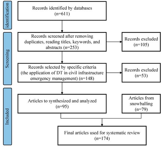
Figure 1.
Paper selection process.
2.2. Statistical Analysis of Data
The scientometric analysis is conducted by CiteSpace, which is information visualisation software that measures and analyses research data and then generates various bibliometric networks. In this study, we developed a keyword co-occurrence network through CiteSpace and visualised the key journals, countries, and time distribution zone, thereby revealing the evolution, the frontier, and the development trends of the research field, which is helpful for further content analysis and qualitative discussions with the mapping results.
2.2.1. Time Distribution Feature Analysis
The number of articles published over time reveals the development trends in a field. Therefore, the number of annually published articles on DT in infrastructure emergency management in the WOS core collection databases was counted. A distribution map was developed to analyse the research trends in this field, as shown in Figure 2. In general, the research on the application of DT in civil infrastructure emergency management shows a positive development trend. From 2013 to 2018, the number of articles in the database was small, indicating that this field was only at its frontier development stage. In recent years, the number of published papers in this field has increased, from 8 in 2013 to 27 in 2022.
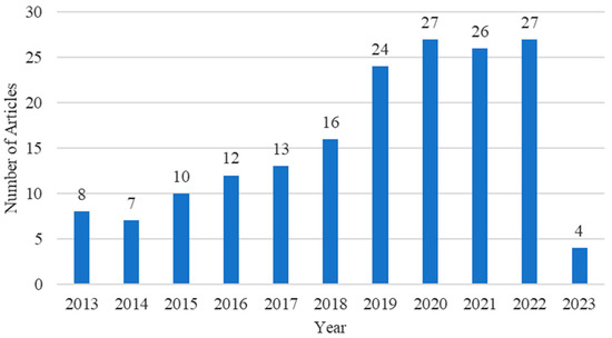
Figure 2.
Number of articles between 2013 and 2023.
2.2.2. Productive Countries Analysis
The node type was set to country, and the threshold of items extracted from each time slice was set to the top 50, after which CiteSpace measured the scientific collaboration between countries by the number of copublished papers. The country of every author was counted, and the co-occurrence network of significant research countries was developed, as shown in Figure 3. In Figure 3, the size of nodes stands for the total number of authors from collaborative papers, and the edges stand for collaborative papers.
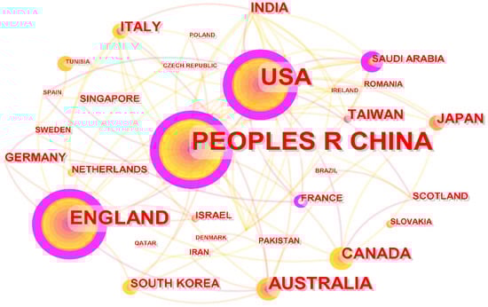
Figure 3.
Co-occurrence map of main research countries.
The quantitative analysis revealed that 94 countries had participated in the research on applying DT in EMCI. In Figure 3, each circle is a node, its size indicates the number of published articles, and the connection between two nodes reflects the collaboration relationship between countries. If the nodes in the network have outer circles, these nodes have high centrality. As shown in Figure 3, China has the largest node size, indicating that China is the most active country in this field. From 2013 to 2023, China published 53 articles, or 29.4% of all the articles. At the same time, China has the highest centrality, of 0.39, which means China has a significant cooperative relationship with other countries. The numbers of articles published in the United States and in Britain are 36 and 20, respectively, second only to China. Other countries, such as Australia, Canada, and Japan, have also been prominent in this research field.
2.2.3. Article Sources Analysis
Academic journals are important information media for communicating, disseminating, and inheriting scientific achievements. Identifying critical journals in the target research field can provide an approach for systematically analysing the research status quo. According to the retrieval results, 180 articles were published by 115 journals. In Figure 4, the top 25 highly cited journals were mapped out in a journal cocitation network. In this network, each node represents a journal, the node size is determined by the total number of times that it was cited, and the link between two nodes indicates that there is a citation relationship between the two journals. Table 1 shows the top 25 high-impact journals between 2013 and 2023.
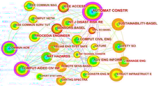
Figure 4.
Top-25 journal cocitation network.

Table 1.
Top-25 high-impact journals, 2013–2023.
Regarding the number of citations in a journal, Automation in Construction has been most cited (48 times), indicating its higher contribution to this knowledge scope. The second-most-cited journal is Computer-Aided Civil and Infrastructure Engineering, which publishes papers related to ICTs and civil and infrastructure engineering. The Journal of Computing in Civil Engineering is ranked third according to the number of citations. Overall, the DT EMCI research demonstrates the multidisciplinary feature and ranges across construction building technology, ICT, sociology, management science, and engineering, to name a few.
2.2.4. Document Citation Analysis
The research topic of DT in emergency response is relatively mature. Table 2 shows the highly cited articles contributed by researchers around the world. The most cited paper is reference [18] (149 times). It proposes a big-data-driven approach for disaster response through sentiment analysis. The practical implication is the real-time categorisation and classification of social media big data for disaster response and recovery. Reference [19] has been cited 103 times, which proposed a disaster-damage-detection method combining machine learning with remote-sensing data, which improved the timeliness and accuracy of emergency responses.
Table 2.
Top-10 highly cited papers.
2.2.5. Keyword Co-Occurrence Analysis
The keywords condense authors’ academic viewpoints, and network analysis and cluster analysis for these words can reveal the research foci across time. The node type was set to keyword, the time slice threshold was set to top 50, and CiteSpace was rerun to analyse the keywords and generate the keyword visualisation maps. In Figure 5, the node size represents the keyword occurrence frequencies, and the link between two nodes represents their co-occurrence in at least one article. There were 252 network nodes and 820 links, the total network density being 0.0259. The analysis revealed that the articles in this field were most related to systems, disaster management, models, networks, digital twins, management, and smart cities.
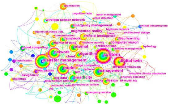
Figure 5.
Keyword co-occurrence network.
CiteSpace also provides citation burst detection to identify which keyword was increasingly cited in a short period. Through this method, several potential trendy research topics can be identified in different periods. Figure 6 demonstrates the keywords with the most robust citation bursts between 2013 and 2023. The top 3 keywords are digital twin (strength = 2.81, 2021–2023), framework (strength = 2.48, 2018–2019), and cloud computing (strength = 2.47, 2013–2015). DT, building information modelling (BIM), and machine learning were the burst keywords in recent years, implying that research interest in these topics has rapidly risen recently.
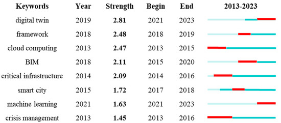
Figure 6.
Top-8 keywords with the strongest citation bursts between 2013 and 2023.
3. Thematic Identification of DT in EMCI
With the development of DT, numerous articles have emerged on the research of DT in infrastructure emergency response, and in many ways, the research has matured and formed a system. Thanks to the above keyword co-occurrence analysis, the cluster analysis function of CiteSpace is indicated and thus used, and the log likelihood ratio algorithm is adopted to cluster the keywords.
As shown in Figure 7, nine main clusters were generated, with a cluster module value of 0.5027 and an average contour value of 0.7819, indicating that there is a high homogeneity among the keywords contained in each cluster module and that there is an inevitable overlap among the cluster modules. On the basis of the connection degree of each cluster member, the knowledge structure of DT in infrastructure emergency responses can be divided into three main topics: (1) the development of DT; (2) critical technologies applied in DT; and (3) the resilience and emergency management of civil infrastructure.
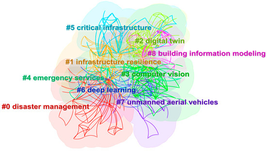
Figure 7.
Keywords clustering network.
3.1. Development of DT
In Clusters 2 and 8, the definition and the application of DT in civil infrastructure were discussed, and the most widely used DT modelling method, BIM, was also introduced.
3.1.1. Definition and Application of DT in Civil Infrastructure
The concept of DT can be traced back to NASA’s Apollo programme, in which NASA built two identical spacecraft, the one left on Earth simulating the spacecraft in space to monitor and predict the status of the spacecraft for decision-making [27]. In order to reduce the time and cost of constructing physical twins, the concept of physical twin is further extended to DT. Grieves [28] proposed the concept of DT in 2011 as a virtual digital representation of a physical product.
DTs contain all the information needed to build the physical entity, digitally representing the physical product. They are also linked to the physical entity through a data thread to test the physical product under simulated conditions. Although the concept originated in the aerospace sector, DTs are being used in several fields, such as industrial manufacturing, big data healthcare, intelligent construction, and smart cities. Table 3 lists the typical definitions of DT across four research fields.
Table 3.
Definitions of DT in different industries.
Therefore, the DTs for civil infrastructure can be defined as dynamic digital replicas of the infrastructure through data from various sources. The DTs of infrastructure can facilitate visual monitoring, dynamic management, and intelligent decision support of emergencies with the help of traffic simulation, data analysis, and other technical means [33].
DTs connect humans and cities in more intelligent, visual, and sustainable ways, and interaction channels with human users are added to bridge the gap between human relationships with cities [34]. With the rapid development of technologies such as the IoT, city information modelling (CIM), and geographic information systems (GISs), the DTs covering large-scale regional information are built, such as the smart city digital twin (SCDT) [35]. The SCDT combines simulation and sensing data to provide intelligent services for urban planning, environmental protection, and traffic control. Similarly, Fan et al. [11] proposed a DT paradigm for disaster management in cities, establishing the role of DT in disaster response and emergency management, including assessment enhancement, decision-making support, and resource allocation. In 2018, the Ali Cloud Research Centre proposed the concept of the urban brain. Using online and intelligent massive multisource data, the urban brain can make large-scale simulations, deductions, and predictions of possible emergencies, thus supporting intelligent decision-making in emergency responses and public services [36].
3.1.2. BIM
DTs have great potential in infrastructure life-cycle management and the integration of various technologies. However, to realise these functions, DTs need to create high-fidelity virtual models to realistically reproduce physical entities’ geometries, attributes, and rules [37]. These models not only are geometrically consistent but can also simulate the spatial-temporal state, behaviours, and functions of the physical entities [38]. The typical virtual modelling methods in DT practice include mainly modelling with three-dimensional (3D) modelling software [39], modelling with measuring instruments and equipment [40], and modelling through multidepth image fusion [41]. As the most widely used DT modelling method, BIM has been thoroughly discussed in Cluster 8.
BIM is a 3D building model based on the relevant information data of construction projects, which simulates the accurate information of buildings through digital information [42]. As a digital representation of civil infrastructure assets, BIM can be used as both an information source and a repository to support various activities in existing infrastructure [34]. In order to meet the industry demand for model interoperability among project participants, BIM has in recent years gradually developed towards semantics. Semantic modelling refers to the automatic identification, classification, and labelling of model elements by a computer programming language and the automatic or semiautomatic design of parameter models by semantic rules [43]. As a modelling language for solving industrial interoperability, industrial foundation classification (IFC) has been used to develop BIM semantic models. It has made remarkable progress in building BIM models through 3D point clouds [44]. However, IFC cannot be modified or used dynamically, so it only partially solves the interoperability problem between all industries [45]. Recently, the web ontology language (OWL) has gradually entered people’s field of vision. It is a new method to ensure the correct alignment between multiple fields and provides better interoperability and reasoning ability [46]. Compared with the old standard file formats, OWL is considered to be more suitable for BIM [47].
BIM is usually constructed by using dense 3D point measurements obtained from laser scanners. In the past, the conversion from laser scanning data to BIM was mainly a manual operation, which required a large number of skilled modellers to work for a long time and was prone to errors [48]. The process of scan-to-BIM makes it possible to generate detailed and accurate models, which promotes the development of BIM automatic modelling. Tang et al. [44] divided the process of scan-to-BIM into three core operations: geometric modelling, object recognition, and relational modelling [49]. Geometric modelling aims to fit geometric primitives to point cloud data to create simplified representations of the 3D shape of building components [38]. Object recognition labels geometric primitives extracted from point cloud data as named objects. Kernel point convolution neural network (KPConv) [50] and dynamic graph convolutional neural networks (DGCNNs) [51] show great potential in extracting geometric information descriptors. Relationship modelling identifies the spatial relationship between building components, including aggregation, topological, and directional relationships. Xiong et al. [52] proposed a method to automatically identify the main indoor building components and modelled the positional relationship between components through visibility reasoning.
3.1.3. DT System Architecture for EMCI
The existing research shows that the new generation of intelligent technology has been applied to solve the EMCI problem [53]. A DT platform connects ubiquitous intelligent terminals, integrates ICTs such as big data and IoT, and fully uses disaster data, which provides a feasible way to effect EMCI [54]. The construction of DT in EMCI generally consists of five layers: a physical layer, data layer, service layer, DT layer, and user-interaction layer, as shown in Figure 8.
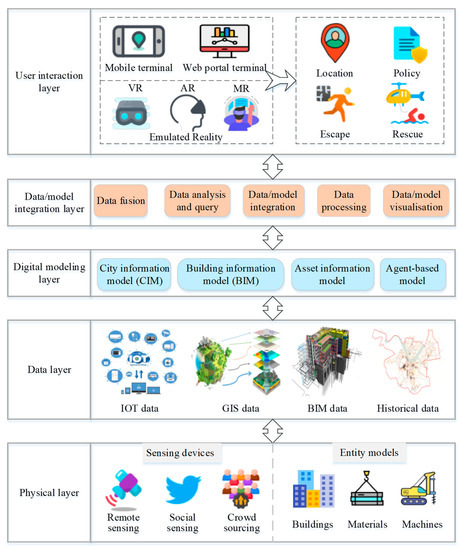
Figure 8.
DT platform framework of EMCI.
The physical layer supports the entire DT system and is responsible for efficiently collecting and safely transmitting information. The information on DT in civil infrastructure comes mainly from remote sensing, social perceptions, and the crowdsourcing of data collection. Remote sensing includes images from satellites and tilt photography taken by uncrewed aerial vehicles (UAVs) [55]. Social sensing is a new method based on data mining and natural language processing (NLP) to obtain disaster information by extracting and analysing social media data [22]. The crowdsourcing of data collection enables people to actively report first-hand real-time information about disasters to online platforms [56]. The physical layer collects data from buildings, materials, machines, and other physical objects involved in the emergency management system.
The data layer integrates technologies such as big data, cloud computing, and virtualisation to provide essential data support for the platform [57]. The disaster data of infrastructure includes model data from GIS, BIM, and IoT; real-time sensing data; and historical disaster data [58]. These kinds of data have comprehensive characteristics and real-time solid performance and are indispensable information sources for evaluating disaster-reduction capacity and formulating disaster strategies.
The digital modelling layer contains a set of digital models of physical assets, supplemented by information supporting the upper layer. Different models in the modelling layer are used for different purposes, such as real-time state control, modelling scenarios, and decision support [59]. BIM describes the city-level information model. As a decision support tool, CIM extends the application of information and intelligent technology at the city level [60]. The asset information model manages equipment, personnel, and production processes with physical entities [61]. When a DT at building and city levels is designed, it is necessary to predefine the standardised modelling process to extend the model from a single infrastructure to the whole city.
The data/model integration layer is the core of DT architecture. This layer aims to manipulate, store, analyse, integrate, and visualise data and models by using intelligent technologies such as artificial intelligence, machine learning, and simulation [62]. With all available data and model resources, it can realise different functions and support advanced decision-making, such as hazard identification and disaster warnings [63].
The user-interaction layer is the top and realisation layer of the DT platform, which realises the interaction between people, society, and digital spaces. Multiterminal forms such as web portal terminals, mobile terminals, and VR/AR terminals are the primary interfaces to realise business management and interactions [64]. This layer mainly provides various services in the disaster management stage, including casualty location and prediction, loss assessment, and disaster relief policy.
3.2. Critical Technologies Applied in DT
The comprehensive application of new technologies has brought profound development to DT. Clusters 3, 6, and 7 feature the critical technologies needed to build DT.
3.2.1. UAVs
In terms of infrastructure emergency response, a DT on massive quantities of real-time data provides a better understanding of the spatial-temporal characteristics of disasters for assessment and decision-making [65]. However, different types of infrastructures have slightly different requirements for disaster data. The spatial-temporal heterogeneous data can be multidimension, multisourced, and multigrain. With the development of theory and technology, data acquisition technologies, including manual modelling, wireless sensors, and UAVs, are widely used in infrastructure disaster data acquisition [66].
UAV remote sensing is a critical technology that integrates UAVs, remote-sensing sensors, communication, and other technologies to rapidly acquire the target information [67]. By carrying multiple sensors on the same flight platform, it simultaneously collects images from one vertical and four oblique angles [68]. Aerial image processing then obtains the subjects’ size, shape, location, nature, and interrelationship, thus quickly establishing an extensive range of 3D scenes with accurate geographical information [69]. It has incomparable advantages such as low cost, strong mobility, flexible data acquisition, timeliness, repeatability, and high resolution [70]. The data obtained can visually and genuinely reflect the basic features of the ground.
UAV oblique photography is affected by external environmental factors, such as light and wind speed. It cannot solve the problems of local texture distortion, feature pulling, and feature hollowness caused by feature occlusion [71]. Although drones are flexible in their operations, they are limited by the angle of aerial photography in carrying out photogrammetric missions. They cannot quickly restore buildings’ more-complex facade structures by accurately obtaining images [72]. Moreover, when UAVs are used for water conservancy projects, most of the images obtained are dominated by the water surface, making it difficult to carry out air-triple encryption calculations and reducing the relative orientation accuracy of the images [73].
A more convenient and economical modelling method using mobile phones or camera photos has appeared. For example, images taken with personal mobile phones and computer-aided design (CAD) drawings were combined to semiautomatically generate the as-is models for existing buildings with the proposed DT system [74]. The aerial photographs were combined with digital surface and elevation models from digital maps and expert experience to generate DT models for existing highways with limited manual workload and satisfactory accuracy [75].
3.2.2. Computer Vision and Deep Learning
With the wide application of UAV remote sensing in DT data acquisition, the automatic understanding of visual data becomes increasingly important, making computer vision and deep learning more closely related to disaster data.
Computer vision is an interdisciplinary field first put forward in the 1960s [76]. The original computer vision system tried to extract the shape information of objects according to possible objects, backgrounds, and chaotic regions [77]. With the development of image mode, computer vision began to consider more-complex perceptual problems, such as face recognition [78], pedestrian detection [79], and car detection [80]. The latest progress in computer vision technology is promoted mainly by using deep-learning algorithms such as artificial neural networks (ANNs) and convolutional neural networks (CNNs), which have achieved remarkable success in building perceptual systems for highly complex visual problems [81]. As a whole, computer vision and deep learning are widely used in many fields, such as general image classification [82] and automatic transportation systems [83]. Similarly, there are many research practices based on computer vision and deep learning in civil infrastructure emergency management.
Combining UAV remote sensing and computer vision technology provides a rapid and automatic monitoring scheme for evaluating civil infrastructure [84]. Computer vision is used mainly for the analysis of images and videos. It can encode information from the whole field of vision in a noncontact way, potentially solving the disadvantages of using contact sensors [85]. Deep learning has dramatically expanded the traditional ability of health detection and damage assessment by using computer vision. Indices for structural condition assessments such as cracks, spalling, and corrosion can be extracted from a visual image of the structural surface and the infrared image of the structural components through image classification, detection, and image segmentation, to detect the changes in infrastructure performance levels and states [86]. Nhat-Duc et al. [87] extracted texture features and shape descriptors from the pavement surface and trained a pavement crack classifier by using a CNN to identify cracks on asphalt pavement. Bao et al. [88] proposed a data anomaly detection method on the basis of using computer vision and deep learning and used a deep neural network to automatically detect the health status of infrastructure structures. Taking some necessary data processing measures in the data collection and analysis stage can help computer vision and deep learning more accurately evaluate the state of infrastructure.
Overall, technology has improved, allowing a better understanding of damages and subsequent cost estimations for repairing or replacing infrastructure. However, there are factors inherent in technology that add uncertainty to the viability of using them. Estimating the cost of technology is a complex undertaking in a nondisaster setting. For instance, the cost of a UAV generally ranges from USD 1000 to USD 10,000, and UAVs are regarded as lower-cost means of collecting aerial imagery, as compared to crewed aerial photography or satellite imagery analysis, but this does not mean that they are cheap within the scale of EMCI, because the software and hardware used to analyse and process drone-collected data, such as images and video, can also be expensive and tedious. The use of AI to predict natural disasters might save millions of lives. However, the cost of AI ranges from USD 6000 to USD 300,000 for a custom solution, and this cost is even greater for more-complicated use scenarios involving multiple factors such as EMCI. That said, deploying AI solutions varies by price and depends on the case. Likewise, deploying a DT requires a considerable investment, in workforce, in time, and in money because DTs are complex digital assets requiring capabilities in model-based system engineering, modelling, data architecture, AI, and ML, to name a few. The use of DT could cost millions or billions of dollars spread over many years and therefore needs a strong political and economic drive.
3.3. Resilience and EMCI
Clusters 0, 1, 4, and 5 focus mainly on the resilience of critical infrastructure and introduce the current state of research on infrastructure emergency management based on resilience. As the scale of critical infrastructure continues to expand, cities show increased vulnerability to emergencies that are increasing in frequency and impact. With the increasing severity of urban disaster risks, the traditional reactive disaster mitigation and emergency response strategies that are based on empirical thinking need to be transformed. Meanwhile, urban resilience introduces a new perspective on urban disaster response from a dynamic perspective.
First introduced in 1973, resilience means a system’s ability to restore its regular status in response to external disturbances, measured by its ability to resist the disturbance and the speed with which the system returns to equilibrium [89]. The resilience theory emphasises not only a city’s ability to respond to disasters but also a city’s ability to adapt to disasters and the ability of people to participate, make decisions, and respond in the disaster response process [90]. As a result, there is a growing consensus among researchers in the field of urban disaster emergency management to improve the resilience of cities, which refers to the ability of urban systems to adapt, recover, and learn from disturbances caused by natural and human-made disasters [91].
Infrastructure resilience assessment allows for the better prediction of hazards to mitigate the consequences of destructive events and better guidance on developing resilience enhancement policies [92]. Bruneau et al. [93] proposed a conceptual framework that states how the four dimensions (technical, organisational, social, and economic) and four primary attributes (robustness, redundancy, speed, and intelligence) of resilience were considered in the assessment of urban resilience. Cutter et al. [94] considered resilience assessment along six dimensions: social, economic, institutional, infrastructural, ecological, and community capacity. David and Simpson [95] argued that resilience indicators should include disaster risk, social capital, community assets, infrastructure quality, and social services. The ratio of preparedness to vulnerability is used as the resilience value. Feng et al. [96] constructed an urban disaster resilience evaluation system with four aspects: ecological resilience, economic resilience, engineering resilience, and social resilience.
In terms of improving the resilience of urban infrastructure, existing research has focused on reducing disaster risks, mitigating the consequences of disasters, and accelerating social functioning recovery [97]. Before the disaster, risk assessment strengthens risk prevention and fills in shortcomings with approaches such as the nonsimultaneous hidden Markov model [98] and the multiscale Bayesian network model [99]. At the same time, the critical infrastructure that affects urban resilience is determined through interdependence analysis. The best dispatching strategy is put forward to maximise the resilience of urban infrastructure and ensure the continuity of infrastructure functions. Yang et al. [100] proposed a comprehensive framework based on physical interdependencies to strengthen the emergency response capacity to mitigate the impact of disasters, providing a multidisciplinary and interactive environment for resilience analysis. After disasters, Zhang et al. [101] proposed an optimal allocation model for infrastructure resources to help decision makers adopt the optimal resource allocation strategy; Kong et al. [102] proposed a two-stage recovery resource allocation model considering the impact of infrastructure interdependence on resource allocation.
However, urban resilience governance is complex and dynamic, with conflicting objectives and ambiguous implementation problems. Smart cities can use DT technology to ensure the accuracy of information transfer through process optimisation, strengthen the ability of public infrastructure to withstand external risks, improve urban resilience governance, and speed up urban emergency responses [103]. Table 4 shows the characteristics of EMCI and the advantages of DT in solving these problems.
Table 4.
Applicability of DT in EMCI.
4. DT Applications for EMCI
As the smart city digital twin develops, the potential to exploit the DT for emergency management also expands. According to the emergency management framework developed by the National Governors Association (NGA) in 1979, emergency management activities can be divided into four stages: mitigation, preparation, response, and recovery [110]. DTs provide reference models for emergency prevention and for the control system by constructing virtual spatial scenarios of emergency events, and they provide key platforms for emergency plans and the evaluation of intervention effects. As shown in Figure 9, DT can be widely used in the four phases of emergency management, providing robust support for infrastructure emergency management.
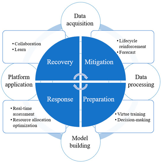
Figure 9.
Framework of DT applications for infrastructure emergency management.
4.1. Mitigation
Critical infrastructures are vulnerable to natural disasters, accidents, and failures, and disaster mitigation includes the activities that prevent and reduce the likelihood of disasters in advance. Because natural disasters and accidents are difficult to control after their occurrence, reducing disaster frequency is essential and often happens through the life-cycle reinforcement for the infrastructure rather than in the operation stage alone. The introduction of DT can effectively improve the intelligence of infrastructure life-cycle management [111].
In the design stage, with the introduction of DT, related information and real-time data can be efficiently organised to help designers make informed decisions. DTs provide great help for the increasing demand for design collaboration by providing more-explicit and more-objective information to relevant stakeholders [112,113]. The more significant interaction between virtual and physical spaces can avoid unreasonable design and ensure the effectiveness of design [114]. DT can realise real-time information sharing and management in the construction stage to ensure construction quality and progress [115]. Through intelligent sensing technologies such as machine vision [116], IoT sensors [117], and deep learning [118], DT can comprehensively monitor the risk factors that will affect engineering quality and make timely adjustments and corrections. For human–machine interactive construction activities (e.g., tower crane hoisting and shield tunnelling), DT can actively track the personnel behaviour data and estimate the posture of construction machinery, thereby monitoring the unsafe construction behaviour [119,120,121].
The anomalous behaviour detection of infrastructure is the primary disaster mitigation measure in the operation stage. By analysing potential risks, decision makers can take preventive actions before catastrophic consequences occur [16]. The traditional anomaly detection process is completed mainly manually by experienced professionals, and it is difficult to systematically integrate various data, leading to a delay in detection [122]. DT can integrate multisource heterogeneous data and efficiently search, verify, query, and manage facility information [123]. With abundant data analysis algorithms, DT can realise the automatic detection of anomalies and dynamically evaluate the service performance of infrastructure [124]. The detected facility anomalies can be used to train machine-learning models to predict the occurrence of the same type of faults in the future [125]. The problem with the anomaly detection process based on DT is that rich facility data will lead to a heavy computational load and affect the real-time performance of detection [126,127]. The latest anomaly detection process applied to building HVAC systems puts forward a data feature extraction and selection method. It makes a new attempt to improve detection efficiency, which will help to realise more real-time and automatic asset monitoring in daily operation and maintenance management [128].
In the mitigation stage, in addition to monitoring infrastructure anomalies, DT can also analyse factors that may lead to disasters (such as natural meteorology, geological structure, and human activities), identify upcoming disasters, and issue early warnings. Traditional disaster prediction methods, including onsite monitoring and expert investigation, have high false-alarm rates. Because DT integrates artificial intelligence methods such as support vector machines and neural networks, it is highly accurate in predicting fire scale, flood degree, and hurricane trajectory [129,130,131]. At the same time, with the maturity of the Internet of Things technology, DT can quickly and accurately share the disaster situation and issue early warnings of the crisis to people who may be affected by the disaster [132].
4.2. Preparation
The need for preparedness activities depends on the extent to which disaster-reduction measures fail or cannot prevent disaster occurrence. During the preparedness phase, emergency plan management and personnel training can strengthen the ability to effectively respond to disasters.
The emergency plan is regarded as the core element of the emergency management life cycle and a vital knowledge source in the response stage [133]. Traditional emergency-planning technologies cannot perceive the dynamic changes during a disaster, which increases the difficulty of emergency rescue once a disaster occurs [134]. DT-driven emergency planning can deduce the evolution trend of emergencies through knowledge retrieval and reasoning according to the potential risks perceived in the mitigation stage [135]. According to the location of emergency resources, the situation of deployable personnel, potentially dangerous areas, and the location of personnel to be rescued, the emergency plan applicable to events is generated and presented to the users for decision-making in a visual form [136,137]. Compared with the decision-making method centred on government departments, interactive group decision-making supported by virtual reality technology gives citizens more rights. Using a big interactive virtual reality screen to present complex information in the emergency plan support communication and decision-making among a large heterogeneous group of citizens builds consensus on crisis decision-making and further improves urban crisis management ability [26].
In order to effectively reduce casualties and save lives during emergency rescues, rescuers and other crucial personnel need safety training to learn the correct life-saving skills [138]. Conventional training methods such as classroom training and emergency exercises have specific effects, but the form is singular, and the sense of experience is poor [139]. Applying VR technology to emergency training can immerse students in complex and diverse training scenarios, especially in some extreme situations that are too dangerous to be trained in the real world [140]. VR can improve the safety and effectiveness of safety training and increase the participation of students so that rescuers can perform better in actual emergency rescue scenarios [141]. VR has been widely used in fire safety training, electric power safety training, and earthquake rescue training [142,143,144,145]. In addition to training rescue crew, VR can simulate the disaster environment and conduct emergency evacuation drills for the masses. Virtual emergency environments can arouse cognitive and behavioural responses, improving people’s adaptability to actual emergencies, thus helping them to appropriately respond when disasters occur [146].
4.3. Response
In response to emergencies, various actions must be immediately taken to save lives and mitigate property and environmental damage. These actions usually include making disaster damage assessments and providing emergency assistance to distressed people.
During damage assessment, social sensing is pivotal in extracting and analysing unstructured data on urban emergencies from social media platforms to evaluate disaster phenomena [147]. Using natural language processing and data-mining technology to analyse the semantic structure implied in the data, direct information such as disaster occurrence time, geographical location, and damage degree can be obtained [148]. This information is helpful in locating the damage, estimating the extent of the affected areas, and assessing disaster losses. Social sensing provides near-real-time transitions of disaster situations and analysis results, which can realise intelligent and quick responses to extreme events in cities [149]. AI provides effective damage assessment approaches in addition to social perceptions. When a disaster occurs, uncrewed aerial vehicles and remote-sensing satellites are used to gather real-time images of disasters, and machine-learning classification algorithms such as CNNs are used to compare the feature differences of infrastructure images taken before and after the crisis, so as to assess the degree of damage and carry out an efficient response [150,151,152].
In the response phase, allocating and scheduling emergency resources is critical to reducing human suffering and casualties [153]. By integrating the information of the affected areas collected by the IoT, drones, satellites, and other similar devices and by collecting victims’ emotions and refuge needs from social media, the material allocation scheme and the priority of rescue tasks are determined. Road monitoring, radio frequency sensors, and other sensing terminals are used to monitor road status and crowd density to provide rescue teams with the most appropriate direction and path and to realise the efficient distribution of emergency resources [154].
4.4. Recovery
Postdisaster recovery includes short-term and long-term activities. Short-term recovery refers to restoring the affected infrastructure to minimum operating standards, while long-term recovery activities aim to restore infrastructure to its predisaster normal state [155]. DT application in recovery involves mainly postdisaster management and system optimisation.
DT provides the city with a postdisaster reconstruction information platform, which can realise information sharing among relevant departments and disaster victims and can coordinate the opinions and requirements of all parties involved in the recovery process [14]. IoT sensors, personal smart terminals, and other similar devices are used to collect information such as the identity of victims, casualties, and economic losses after the disaster [156]. By analysing and integrating this information, the government can efficiently and accurately complete postdisaster coordination work such as disaster relief and disaster-related information release and quickly restore regular order to the city.
Therefore, the postdisaster information in the DT platform provides urban-planning administrators and disaster control departments with a comprehensive analysis of the damage caused by disasters and the vulnerabilities in the disaster prevention system to optimise urban disaster prevention practices [157]. On this basis, the loopholes in the urban infrastructure emergency response system will be closed and improved, and the comprehensive emergency response capability will be continuously improved to minimise the damage in response to the next disaster [158].
5. Trends and Prospects of DT for Civil Infrastructure Emergency Management
5.1. Fast Modelling with Semantic Enrichment
In constructing DT for civil infrastructure, it is always time-consuming and labour-intensive to convert data collected from point clouds and oblique photography to BIM models, which takes up 90% of the time and effort needed [145]. The only possible way to reduce the time and cost of as-is models for civil infrastructure is to use automated and fast modelling with semantic enrichment for advancing scan-to-BIM reconstruction approaches [146]. Figure 10 shows the procedure of fast modelling with semantic enrichment.
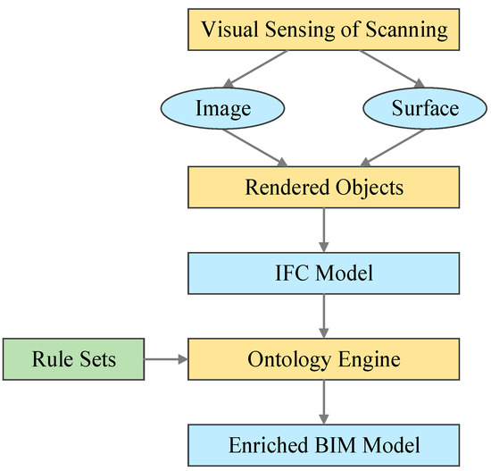
Figure 10.
Procedure of fast modelling with semantic enrichment (adapted from [159]).
Semantic enrichment usually refers to adding semantic information to IFC files with domain expert knowledge for increased interoperability, fast modelling, and compliance checking. It has been used in the inspection of highway bridges in enormous numbers as an innovative, intelligent, and rapid solution [160]. The proposed engine added new facts with inferred expert knowledge in if-then rule sets into IFC files of bridges and wrote new IFC files [160,161]. Therefore, the 3D construct items generated by computer vision approaches were enriched with identified element names and their functional relationships rather than mere geometry attributes.
The key steps of the semantic enrichment of BIM and CIM models are acquiring new semantics and enrichment methods. The sources include both vector data and raster data. However, built-in rules are necessary for semantic enrichment approaches to add new information solicited and compiled from domain experts, including pairwise topological relationships, logical relationships, and spatial relationships [159].
In recent years, machine-learning algorithms have been applied to the semantic enrichment of generating models. For example, Wang et al. [162] applied graph neural networks to classify rooms, enrich apartment models with their room types, and further compliance-checking tasks.
5.2. Infrastructure Knowledge Management and Decision-Making
The threat of emergencies to the safety of people’s lives and property is becoming increasingly severe, and research efforts on evacuation strategies for emergencies [163], emergency disposal site planning [164], emergency repair simulation [165], and so on have increased. However, an emergency response requires comprehensive and integrated knowledge management to be efficient and effective [166]. Although numerous data have been accumulated on civil infrastructure, the problem of quickly and accurately extracting and obtaining the required knowledge from a large number of data in a specific emergency needs to be addressed [167].
A knowledge graph is a knowledge database representing the concepts in the real world and the relationships between them in a graph. Knowledge graphs use ontology repositories to support axioms, rules, and constraints to regulate entity relationships and the connections between objects, such as the types and attributes of entities. Knowledge ontology in emergency risks has been conducted in the research fields of food safety emergency management [168], public health incident emergency management [169], and marine emergency management [170]. Existing research constructed domain ontology; elaborated the classes, relationships, and attributes of the ontology models; and established a unified formal representation.
Regarding disaster emergency knowledge, Jung and Chung [171] united four elements of natural disaster events, disaster emergency tasks, disaster data, and modelling methods to build a natural disaster knowledge graph. Other researchers also proposed ontology-based natural disaster knowledge representation methods [172] and ontology configuration that were based on situational posture derivation for ontology fusion [173]. Determining the geographic ontology of emergency response knowledge and integrating technology with GIS platforms for the spatiotemporal attributes of natural disasters are also proposed [174].
Because of the complex emergency management process and uncertainties, making full use of the disaster history data relevant to the decision-making process is necessary. Integrating various decision support tools, such as data mining and route selection, can provide decision support for decision makers [175]. The current research on decision support optimises the location planning of evacuation sites, emergency supplies deployment, and coordination among decision-making groups.
The principles and methods of evacuation site planning have been proposed from different research perspectives, such as site suitability evaluation [176] and layout optimisation [177]. Improved particle swarm optimisation algorithms have optimised the location layout and evacuation strategy of earthquake emergency evacuation sites [178,179]. GIS has a powerful analysis function for spatial information, and a GIS-based evacuation decision support system that integrates multiobjective models and algorithms for evacuation site selection have been developed [180,181].
Postdisaster emergency material deployment requires decision makers to coordinate various aspects, such as the stock and type of emergency materials, supply points, and disaster sites, to quickly dispatch emergency materials [182,183]. Existing studies have established a series of optimisation models for material deployments, such as the resource allocation models considering route disruption and transportation time uncertainty [184], the vehicle scheduling models aiming at the shortest transportation time [185], and the material distribution models considering the amount of resource deployment and the degree of disaster risk [186]. The most commonly used algorithms to solve the models are genetic algorithms [187] and heuristic algorithms [182].
Emergency decision-making is a dynamic interaction process that requires timely communication and coordination among relevant administrative departments. The transmission and the sharing of information are essential to ensuring decision makers’ ability to collaborate [188]. The modular design ideas and complex problem decomposition techniques were used to discuss emergency decision-making systems’ information sharing and information interaction processes between different departments [189], and they were further developed into the synergy matrix and multiattribute decision theory to establish a dynamic and collaborative emergency decision-making approach [190].
5.3. Quality and Secure Decision-Making
As the Centre of Digital Built Britain stated in the principles for DT, DT’s security and quality must be trustworthy [32]. However, smart cities and critical infrastructures are vulnerable to cyberattacks such as communications hijacking, mobile ransomware, and manipulated sensor data. The risks can be extended to self-driving cars [191]. The cybersecurity issues in developing and exploiting DT for smart cities are essential for responsible decision-making. Future research may include the technological and managerial approaches against cybersecurity risks in data analysis, data management, policymaking, and governance. Conventionally, the methods for cybersecurity include firewalls, antivirus software, intrusion detection and prevention systems, and data leakage prevention systems. The frontier research has identified deep-learning algorithms such as the Boltzmann machine, deep belief networks, recurrent neural networks, convolutional neural networks, and generative adversarial networks as possible methods to overcome cybersecurity challenges [25]. Blockchain technology can also confront cyberattacks by providing a distributed, trusted, and secured data environment [192]. Furthermore, policy frameworks [193] and managerial methods [194] for cybersecurity have also been discussed and developed.
Meanwhile, data quality in developing and exploiting DT models is also essential to the uptake of advanced technologies. The quality of the DT models includes but is not limited to whether the geometry of the components is accurately identified, whether a component is modelled with the correct object type, and whether the relationships between components have been correctly established [195,196]. In developing DT models, the quality of data collection substantially affects the model quality [48]. The International Standard Organisation published ISO 19157 to identify data-quality elements, including data completeness, metric accuracy, and thematic accuracy [197]. Data quality is decided by the scanning settings (e.g., locations, orientations, and resolutions), and scanning planning is an effective method to improve data quality. Geometric feature clustering can reduce the computational complexity of scan planning and quickly determine the optimal scanning location [198]. At the same time, the genetic algorithm (GA) is also used to find the optimal scanning positions and parameters that satisfy the user-defined data-quality requirements [199]. The appropriate angular resolution setting can be estimated on the basis of simulations and mathematical reasoning, and optimised scanning plans can be designed [200].
6. Discussion and Future Research Direction
This paper comprehensively summarised the application of DT in EMCI through bibliometrics analysis, introducing different indicative approaches. However, EMCI should be improved in several ways. First, many data-related challenges should be addressed in applying DT to EMCI. The application of DT needs the fast collection of the infrastructure-related data through remote-sensing satellites, social perceptions, and crowdsourcing platforms, among others, for situational awareness; however, the raw data often contain noise, rumours, and false information. For example, the original data from social media contain different kinds of errors and prejudices, making them untrustworthy. Therefore, in the future research, natural language processing and machine-learning technology should be included to filter and verify the data, providing powerful data marking and rumour detection. Meanwhile, because of national security concerns and commercial competitiveness, it is usually difficult to access several infrastructure data sources, which leads to the incompleteness of disaster data. DT’s collection and analysis of disaster data may also involve personal privacy and moral issues. Therefore, it is necessary to establish appropriate policies and regulations for data collection, protection and management.
Second, DT uses a variety of artificial intelligence technologies to predict the disaster dynamics for decision-making, and the explicability of the prediction is another challenge. Therefore, in the future research, DT designers should as much as possible improve the interpretability in the development process to improve the willingness of emergency decision makers to accept the results of DT. Finally, at present, the research on applying DT to EMCI tends to strengthen the capacity of infrastructure, and the research on human emergency behaviour and responses is relatively lacking. In the future, more human activities should be integrated into the EMCI process to better learn and describe the interaction between human beings and infrastructure in the emergency management process, thus improving the efficiency of emergency responses.
Despite the implications, there are still some limitations in this study. Owing to the design of the research methods, this research pays attention only to the academic literature retrieved from the WOS core database, and not all the literature that is used in EMCI with digital twins are included in the scope of this review, so some clues on this topic have been omitted. If more-extensive literature can be obtained from other databases (such as Scopus and Google Scholar) for similar research, the research results can become more comprehensive. In addition, thanks to the rapid development of digital twins in recent years, research publications on digital twins in the EMCI industry show an increasing trend year by year. The results obtained in this paper are dynamic and will change with the passage of time. In the next few years, we should repeat the research steps in this paper to ascertain the latest research progress in this field.
7. Conclusions
Developments in DT and smart cities have enabled advances in EMCI. Acknowledging the cutting-edge technologies in DT and emergency management, we addressed the following research question: what developments in constructing and exploiting DT can be used to improve emergency management for civil infrastructure, and what are the prospects of such research?
We conducted a systematic literature review of DT within the context of civil infrastructure and emergency management. The main research topics of DT in the field of EMCI were determined: (1) the development of DT; (2) critical technologies applied in DT; and (3) the resilience and emergency management of civil infrastructure.
On applying DT to civil infrastructure emergency management, we proposed a framework that specifies how DT facilitated (1) life-cycle reinforcement for the mitigation stage; (2) virtue planning, training, and decision-making for the preparation stage; (3) real-time assessment and resource allocation optimisation for the response stage; and (4) collaboration and learning for the recovery stage of emergency management.
Given the advancements in DT, we proposed that the challenges and prospects of exploiting DT in the emergency management for civil infrastructure included (1) fast modelling from vector and raster data to digital models with semantic enrichment techniques; (2) advancing knowledge management techniques for agile and active emergency management; and (3) providing technical, contractual, and managerial approaches for cybersecurity and data-quality issues.
First, this study provides systematic knowledge on DT applications in the EMCI industry for researchers in different fields, facilitating their understanding of the integration of EMCI and DT in theory and promoting the development and innovation of DT applications in EMCI. Second, the results of this review provide insights for academics and practitioners for the development of more-feasible DTs to meet the increasing emergency management needs of infrastructure.
Author Contributions
Conceptualisation, R.C., L.H. and S.X.; methodology, R.C. and L.H.; formal analysis, R.C. and S.X.; data curation, R.C.; investigation, R.C., L.H. and S.X.; resources, R.C. and S.X.; writing—original draft preparation, R.C. and S.X.; writing—review and editing, R.C., L.H. and S.X. All authors have read and agreed to the published version of the manuscript.
Funding
This research was funded by the Shaanxi Province Natural Science Foundation, grant number 2021KWZ-28, and by the Science and Technology Project of the Sichuan Transportation Department (2022-ZL-04). The APC was funded by 2022-ZL-04.
Data Availability Statement
Some or all of the data that support the findings of this study are available from the corresponding author upon reasonable request.
Conflicts of Interest
The authors declare no conflict of interest.
References
- Goff, J. New Zealand’s tsunami death toll rises. Nat. Hazard. 2021, 107, 1925–1934. [Google Scholar] [CrossRef]
- Klaver, M.H.; Luiijf, H.; Nieuwenhuijs, A.N.; van Os, N.; Oskam, V. Critical infrastructure assessment by emergency management. In Proceedings of the Critical Information Infrastructures Security: 10th International Conference, CRITIS 2015, Berlin, Germany, 5–7 October 2015; Revised Selected Papers 10. Springer: Berlin/Heidelberg, Germany, 2016; pp. 79–90. [Google Scholar]
- Taubenböck, H.; Goseberg, N.; Lämmel, G.; Setiadi, N.; Schlurmann, T.; Nagel, K.; Siegert, F.; Birkmann, J.; Traub, K.-P.; Dech, S. Risk reduction at the “Last-Mile”: An attempt to turn science into action by the example of Padang, Indonesia. Nat. Hazard. 2013, 65, 915–945. [Google Scholar] [CrossRef]
- Novelo-Casanova, D.A.; Suárez, G.; Cabral-Cano, E.; Fernández-Torres, E.A.; Fuentes-Mariles, O.A.; Havazli, E.; Jaimes, M.Á.; López-Espinoza, E.D.; Martin-Del Pozzo, A.L.; Morales-Barrera, W.V. The Risk Atlas of Mexico City, Mexico: A tool for decision-making and disaster prevention. Nat. Hazard. 2021, 111, 411–437. [Google Scholar] [CrossRef]
- Lu, Y.; Li, R. Rebuilding resilient homeland: An NGO-led post-Lushan earthquake experimental reconstruction program. Nat. Hazard. 2020, 104, 853–882. [Google Scholar] [CrossRef]
- Gjøsæter, T.; Radianti, J.; Chen, W. Universal design of ICT for emergency management: A systematic literature review and research agenda. In Proceedings of the Universal Access in Human-Computer Interaction. Methods, Technologies, and Users: 12th International Conference, UAHCI 2018, Held as Part of HCI International 2018, Las Vegas, NV, USA, 15–20 July 2018; Proceedings, Part I 12. Springer: Berlin/Heidelberg, Germany, 2018; pp. 63–74. [Google Scholar]
- Hamadache, B.; Seridi-Bouchelaghem, H.; Farah, N. A significant core structure inside the social network evolutionary process. Soc. Netw. Anal. Min. 2016, 6, 38. [Google Scholar] [CrossRef]
- Pohl, D.; Bouchachia, A.; Hellwagner, H. Automatic identification of crisis-related sub-events using clustering. In Proceedings of the 2012 11th International Conference on Machine Learning and Applications, Boca Raton, FL, USA, 12–15 December 2012; pp. 333–338. [Google Scholar]
- Fragkos, G.; Apostolopoulos, P.A.; Tsiropoulou, E.E. ESCAPE: Evacuation strategy through clustering and autonomous operation in public safety systems. Future Internet 2019, 11, 20. [Google Scholar] [CrossRef]
- Wang, H.; Ye, H.; Liu, L.; Li, J. Evaluation and Obstacle Analysis of Emergency Response Capability in China. Int. J. Environ. Res. Public Health 2022, 19, 10200. [Google Scholar] [CrossRef]
- Fan, C.; Zhang, C.; Yahja, A.; Mostafavi, A. Disaster City Digital Twin: A vision for integrating artificial and human intelligence for disaster management. Int. J. Inf. Manag. 2021, 56, 102049. [Google Scholar] [CrossRef]
- Sasaki, J.; Kitsuya, M. Development and evaluation of regional information sharing system (RISS) for disaster risk reduction. Inf. Syst. Front. 2021, 23, 1203–1211. [Google Scholar] [CrossRef]
- White, G.; Zink, A.; Codecá, L.; Clarke, S. A digital twin smart city for citizen feedback. Cities 2021, 110, 103064. [Google Scholar] [CrossRef]
- Ford, D.N.; Wolf, C.M. Smart Cities with Digital Twin Systems for Disaster Management. J. Manag. Eng. 2020, 36, 04020027. [Google Scholar] [CrossRef]
- Yu, D.; He, Z. Digital twin-driven intelligence disaster prevention and mitigation for infrastructure: Advances, challenges, and opportunities. Nat. Hazard. 2022, 112, 1–36. [Google Scholar] [CrossRef] [PubMed]
- Doğan, Ö.; Şahin, O.; Karaarslan, E. Digital twin based disaster management system proposal: DT-DMS. J. Emerg. Comput. Technol. 2021, 1, 25–30. [Google Scholar]
- Liu, C.; Ouyang, M.; Wang, N.; Mao, Z.; Xu, X. A heuristic method to identify optimum seismic retrofit strategies for critical infrastructure systems. Comput. Aided Civ. Infrastruct. Eng. 2021, 36, 996–1012. [Google Scholar] [CrossRef]
- Ragini, J.R.; Anand, P.R.; Bhaskar, V. Big data analytics for disaster response and recovery through sentiment analysis. Int. J. Inf. Manag. 2018, 42, 13–24. [Google Scholar] [CrossRef]
- Cooner, A.J.; Shao, Y.; Campbell, J.B. Detection of urban damage using remote sensing and machine learning algorithms: Revisiting the 2010 Haiti earthquake. Remote Sens. 2016, 8, 868. [Google Scholar] [CrossRef]
- Zhu, J.; Wang, X.; Chen, M.; Wu, P.; Kim, M.J. Integration of BIM and GIS: IFC geometry transformation to shapefile using enhanced open-source approach. Autom. Constr. 2019, 106, 102859. [Google Scholar] [CrossRef]
- Lu, Q.; Parlikad, A.K.; Woodall, P.; Don Ranasinghe, G.; Xie, X.; Liang, Z.; Konstantinou, E.; Heaton, J.; Schooling, J. Developing a digital twin at building and city levels: Case study of West Cambridge campus. J. Manag. Eng. 2020, 36, 05020004. [Google Scholar] [CrossRef]
- Zhang, C.; Fan, C.; Yao, W.; Hu, X.; Mostafavi, A. Social media for intelligent public information and warning in disasters: An interdisciplinary review. Int. J. Inf. Manag. 2019, 49, 190–207. [Google Scholar] [CrossRef]
- Haworth, B.; Bruce, E. A review of volunteered geographic information for disaster management. Geogr. Compass 2015, 9, 237–250. [Google Scholar] [CrossRef]
- Cheng, M.-Y.; Chiu, K.-C.; Hsieh, Y.-M.; Yang, I.-T.; Chou, J.-S.; Wu, Y.-W. BIM integrated smart monitoring technique for building fire prevention and disaster relief. Autom. Constr. 2017, 84, 14–30. [Google Scholar] [CrossRef]
- Chen, D.; Wawrzynski, P.; Lv, Z. Cyber security in smart cities: A review of deep learning-based applications and case studies. Sustain. Cities Soc. 2021, 66, 102655. [Google Scholar] [CrossRef]
- Dembski, F.; Wössner, U.; Letzgus, M.; Ruddat, M.; Yamu, C. Urban digital twins for smart cities and citizens: The case study of Herrenberg, Germany. Sustainability 2020, 12, 2307. [Google Scholar] [CrossRef]
- Rosen, R.; von Wichert, G.; Lo, G.; Bettenhausen, K.D. About The Importance of Autonomy and Digital Twins for the Future of Manufacturing. IFAC-Pap. 2015, 48, 567–572. [Google Scholar] [CrossRef]
- Grieves, M. Virtually Perfect: Driving Innovative and Lean Products through Product Lifecycle Management; Space Coast Press: Cocoa Beach, FL, USA, 2011. [Google Scholar]
- Grieves, M.; Vickers, J. Digital Twin: Mitigating Unpredictable, Undesirable Emergent Behavior in Complex Systems. In Transdisciplinary Perspectives on Complex Systems: New Findings and Approaches; Kahlen, F.-J., Flumerfelt, S., Alves, A., Eds.; Springer International Publishing: Cham, Switzerland, 2017; pp. 85–113. [Google Scholar]
- Glaessgen, E.H.; Stargel, D. In The Digital Twin Paradigm for Future NASA and U.S. Air Force Vehicles. In Proceedings of the 53rd AIAA/ASME/ASCE/AHS/ASC Structures, Structural Dynamics and Materials Conference 20th AIAA/ASME/AHS Adaptive Structures Conference, Honolulu, HI, USA, 23–26 April 2012. [Google Scholar]
- Catapult, H.V.M. Feasibility of an immersive digital twin: The definition of a digital twin and discussions around the benefit of immersion. In UK: HVM Catapult Visualisation and VR Forum; Digital Catapult: London, UK, 2018. [Google Scholar]
- Bolton, A.; Enzer, M.; Schooling, J. The Gemini Principles: Guiding Values for the National Digital Twin and Information Management Framework; Centre for Digital Built Britain and Digital Framework Task Group: London, UK, 2018. [Google Scholar]
- Deng, M.; Menassa, C.C.; Kamat, V.R. From BIM to digital twins: A systematic review of the evolution of intelligent building representations in the AEC-FM industry. J. Inf. Technol. Constr. 2021, 26, 58–83. [Google Scholar] [CrossRef]
- Lu, Q.; Xie, X.; Parlikad, A.K.; Schooling, J.M.; Konstantinou, E. Moving from building information models to digital twins for operation and maintenance. Proc. Inst. Civ. Eng. Smart Infrastruct. Constr. 2020, 174, 46–56. [Google Scholar] [CrossRef]
- Tao, F.; Zhang, H.; Liu, A.; Nee, A.Y.C. Digital Twin in Industry: State-of-the-Art. IEEE Trans. Ind. Inf. 2019, 15, 2405–2415. [Google Scholar] [CrossRef]
- Zhang, J.; Hua, X.S.; Huang, J.; Shen, X.; Chen, J.; Zhou, Q.; Fu, Z.; Zhao, Y. City brain: Practice of large-scale artificial intelligence in the real world. IET Smart Cities 2019, 1, 28–37. [Google Scholar] [CrossRef]
- Schluse, M.; Rossmann, J. In From simulation to experimentable digital twins: Simulation-based development and operation of complex technical systems. In Proceedings of the 2016 IEEE International Symposium on Systems Engineering (ISSE), Edinburgh, UK, 3–5 October 2016; pp. 1–6. [Google Scholar]
- Boje, C.; Guerriero, A.; Kubicki, S.; Rezgui, Y. Towards a semantic Construction Digital Twin: Directions for future research. Autom. Constr. 2020, 114, 103179. [Google Scholar] [CrossRef]
- Lin, K.; Xu, Y.-L.; Lu, X.; Guan, Z.; Li, J. Digital twin-based collapse fragility assessment of a long-span cable-stayed bridge under strong earthquakes. Autom. Constr. 2021, 123, 103547. [Google Scholar] [CrossRef]
- Döllner, J. Geospatial artificial intelligence: Potentials of machine learning for 3D point clouds and geospatial digital twins. PFG J. Photogramm. Remote Sens. Geoinf. Sci. 2020, 88, 15–24. [Google Scholar] [CrossRef]
- Zheng, Y.; Wang, S.; Li, Q.; Li, B. Fringe projection profilometry by conducting deep learning from its digital twin. Opt. Express 2020, 28, 36568–36583. [Google Scholar] [CrossRef] [PubMed]
- Kubicki, S.; Guerriero, A.; Schwartz, L.; Daher, E.; Idris, B. Assessment of synchronous interactive devices for BIM project coordination: Prospective ergonomics approach. Autom. Constr. 2019, 101, 160–178. [Google Scholar] [CrossRef]
- Belsky, M.; Sacks, R.; Brilakis, I. Semantic enrichment for building information modeling. Comput. Aided Civ. Infrastruct. Eng. 2016, 31, 261–274. [Google Scholar] [CrossRef]
- Zhao, X. A scientometric review of global BIM research: Analysis and visualization. Autom. Constr. 2017, 80, 37–47. [Google Scholar] [CrossRef]
- Lee, Y.-C.; Eastman, C.M.; Lee, J.-K. Validations for ensuring the interoperability of data exchange of a building information model. Autom. Constr. 2015, 58, 176–195. [Google Scholar] [CrossRef]
- Pauwels, P.; Van Deursen, D.; Verstraeten, R.; De Roo, J.; De Meyer, R.; Van de Walle, R.; Van Campenhout, J. A semantic rule checking environment for building performance checking. Autom. Constr. 2011, 20, 506–518. [Google Scholar] [CrossRef]
- Pauwels, P.; Zhang, S.; Lee, Y.-C. Semantic web technologies in AEC industry: A literature overview. Autom. Constr. 2017, 73, 145–165. [Google Scholar] [CrossRef]
- Wang, Q.; Li, J.; Tang, X.; Zhang, X. How data quality affects model quality in scan-to-BIM: A case study of MEP scenes. Autom. Constr. 2022, 144, 104598. [Google Scholar] [CrossRef]
- Tang, P.; Huber, D.; Akinci, B.; Lipman, R.; Lytle, A. Automatic reconstruction of as-built building information models from laser-scanned point clouds: A review of related techniques. Autom. Constr. 2010, 19, 829–843. [Google Scholar] [CrossRef]
- Thomas, H.; Qi, C.R.; Deschaud, J.-E.; Marcotegui, B.; Goulette, F.; Guibas, L.J. KPConv: Flexible and deformable convolution for point clouds. In Proceedings of the IEEE/CVF International Conference on Computer Vision, Seoul, Republic of Korea, 27 October–2 November 2019; pp. 6411–6420. [Google Scholar]
- Wang, Y.; Sun, Y.; Liu, Z.; Sarma, S.E.; Bronstein, M.M.; Solomon, J.M. Dynamic graph CNN for learning on point clouds. Acm Trans. Graph. (Tog) 2019, 38, 1–12. [Google Scholar] [CrossRef]
- Xiong, X.; Adan, A.; Akinci, B.; Huber, D. Automatic creation of semantically rich 3D building models from laser scanner data. Autom. Constr. 2013, 31, 325–337. [Google Scholar] [CrossRef]
- Fan, C.; Mostafavi, A. Metanetwork framework for performance analysis of disaster management system-of-systems. IEEE Syst. J. 2019, 14, 1265–1276. [Google Scholar] [CrossRef]
- Kwon, J.-W.; Yun, S.-J.; Kim, W.-T. A semantic data-based distributed computing framework to accelerate digital twin services for large-scale disasters. Sensors 2022, 22, 6749. [Google Scholar] [CrossRef] [PubMed]
- Akter, S.; Wamba, S.F. Big data and disaster management: A systematic review and agenda for future research. Ann. Oper. Res. 2019, 283, 939–959. [Google Scholar] [CrossRef]
- Ofli, F.; Meier, P.; Imran, M.; Castillo, C.; Tuia, D.; Rey, N.; Briant, J.; Millet, P.; Reinhard, F.; Parkan, M. Combining human computing and machine learning to make sense of big (aerial) data for disaster response. Big Data 2016, 4, 47–59. [Google Scholar] [CrossRef] [PubMed]
- Hu, Z.-Z.; Tian, P.-L.; Li, S.-W.; Zhang, J.-P. BIM-based integrated delivery technologies for intelligent MEP management in the operation and maintenance phase. Adv. Eng. Softw. 2018, 115, 1–16. [Google Scholar] [CrossRef]
- Hirohara, Y.; Ishida, T.; Uchida, N.; Shibata, Y. Proposal of a disaster information cloud system for disaster prevention and reduction. In Proceedings of the 2017 31st International Conference on Advanced Information Networking and Applications Workshops (WAINA), Taipei, Taiwan, 27–29 March 2017; pp. 664–667. [Google Scholar]
- Kim, K.; Cho, Y.K.; Kim, K. BIM-based decision-making framework for scaffolding planning. J. Manag. Eng. 2018, 34, 04018046. [Google Scholar] [CrossRef]
- Gil, J. City Information Modelling: Digital Planning for Sustainable Cities. Built Environ. 2020, 46, 497–500. [Google Scholar] [CrossRef]
- Heaton, J.; Parlikad, A.K.; Schooling, J. A Building Information Modelling approach to the alignment of organisational objectives to Asset Information Requirements. Autom. Constr. 2019, 104, 14–26. [Google Scholar] [CrossRef]
- Silva, B.N.; Khan, M.; Han, K. Integration of Big Data analytics embedded smart city architecture with RESTful web of things for efficient service provision and energy management. Future Gener. Comput. Syst. 2020, 107, 975–987. [Google Scholar] [CrossRef]
- Cheng, M.-Y.; Wu, Y.-W. Multi-agent-based data exchange platform for bridge disaster prevention: A case study in Taiwan. Nat. Hazard. 2013, 69, 311–326. [Google Scholar] [CrossRef]
- Ke, S.; Xiang, F.; Zhang, Z.; Zuo, Y. A enhanced interaction framework based on VR, AR and MR in digital twin. Procedia CIRP 2019, 83, 753–758. [Google Scholar] [CrossRef]
- Sun, W.; Bocchini, P.; Davison, B.D. Applications of artificial intelligence for disaster management. Nat. Hazard. 2020, 103, 2631–2689. [Google Scholar] [CrossRef]
- Li, L.; Aslam, S.; Wileman, A.; Perinpanayagam, S. Digital twin in aerospace industry: A gentle introduction. IEEE Access 2021, 10, 9543–9562. [Google Scholar] [CrossRef]
- Osco, L.P.; Junior, J.M.; Ramos, A.P.M.; de Castro Jorge, L.A.; Fatholahi, S.N.; de Andrade Silva, J.; Matsubara, E.T.; Pistori, H.; Gonçalves, W.N.; Li, J. A review on deep learning in UAV remote sensing. Int. J. Appl. Earth Obs. Geoinf. 2021, 102, 102456. [Google Scholar] [CrossRef]
- Aasen, H.; Honkavaara, E.; Lucieer, A.; Zarco-Tejada, P.J. Quantitative remote sensing at ultra-high resolution with UAV spectroscopy: A review of sensor technology, measurement procedures, and data correction workflows. Remote Sens. 2018, 10, 1091. [Google Scholar] [CrossRef]
- Zhang, C.; Tang, Z.; Zhang, M.; Wang, B.; Hou, L. Developing a more reliable aerial photography-based method for acquiring freeway traffic data. Remote Sens. 2022, 14, 2202. [Google Scholar] [CrossRef]
- Yao, H.; Qin, R.; Chen, X. Unmanned aerial vehicle for remote sensing applications—A review. Remote Sens. 2019, 11, 1443. [Google Scholar] [CrossRef]
- Liu, S.; Cheng, J.; Liang, L.; Bai, H.; Dang, W. Light-weight semantic segmentation network for UAV remote sensing images. IEEE J. Sel. Top. Appl. Earth Obs. Remote Sens. 2021, 14, 8287–8296. [Google Scholar] [CrossRef]
- Torresan, C.; Berton, A.; Carotenuto, F.; Di Gennaro, S.F.; Gioli, B.; Matese, A.; Miglietta, F.; Vagnoli, C.; Zaldei, A.; Wallace, L. Forestry applications of UAVs in Europe: A review. Int. J. Remote Sens. 2017, 38, 2427–2447. [Google Scholar] [CrossRef]
- Yuan, C.; Zhang, Y.; Liu, Z. A survey on technologies for automatic forest fire monitoring, detection, and fighting using unmanned aerial vehicles and remote sensing techniques. Can. J. For. Res. 2015, 45, 783–792. [Google Scholar] [CrossRef]
- Lu, Q.; Chen, L.; Li, S.; Pitt, M. Semi-automatic geometric digital twinning for existing buildings based on images and CAD drawings. Autom. Constr. 2020, 115, 103183. [Google Scholar] [CrossRef]
- Jiang, F.; Ma, L.; Broyd, T.; Chen, W.; Luo, H. Building digital twins of existing highways using map data based on engineering expertise. Autom. Constr. 2022, 134, 104081. [Google Scholar] [CrossRef]
- Dong, C.-Z.; Catbas, F.N. A review of computer vision–based structural health monitoring at local and global levels. Struct. Health Monit. 2021, 20, 692–743. [Google Scholar] [CrossRef]
- Voulodimos, A.; Doulamis, N.; Doulamis, A.; Protopapadakis, E. Deep learning for computer vision: A brief review. Comput. Intell. Neurosci. 2018, 2018, 7068349. [Google Scholar] [CrossRef]
- Zhang, K.; Zhang, Z.; Li, Z.; Qiao, Y. Joint face detection and alignment using multitask cascaded convolutional networks. IEEE Signal Process Lett. 2016, 23, 1499–1503. [Google Scholar] [CrossRef]
- Zhang, H.-B.; Zhang, Y.-X.; Zhong, B.; Lei, Q.; Yang, L.; Du, J.-X.; Chen, D.-S. A comprehensive survey of vision-based human action recognition methods. Sensors 2019, 19, 1005. [Google Scholar] [CrossRef]
- Guo, M.-H.; Xu, T.-X.; Liu, J.-J.; Liu, Z.-N.; Jiang, P.-T.; Mu, T.-J.; Zhang, S.-H.; Martin, R.R.; Cheng, M.-M.; Hu, S.-M. Attention mechanisms in computer vision: A survey. Comput. Vis. Media 2022, 8, 331–368. [Google Scholar] [CrossRef]
- Wu, S.; Zhong, S.; Liu, Y. Deep residual learning for image steganalysis. Multimed. Tools Appl. 2018, 77, 10437–10453. [Google Scholar] [CrossRef]
- Yeum, C.M.; Choi, J.; Dyke, S.J. Automated region-of-interest localization and classification for vision-based visual assessment of civil infrastructure. Struct. Health Monit. 2019, 18, 675–689. [Google Scholar] [CrossRef]
- Simonyan, K.; Zisserman, A. Very deep convolutional networks for large-scale image recognition. arXiv 2014, arXiv:1409.1556. [Google Scholar]
- Feng, D.; Feng, M.Q. Computer vision for SHM of civil infrastructure: From dynamic response measurement to damage detection–A review. Eng. Struct. 2018, 156, 105–117. [Google Scholar] [CrossRef]
- Spencer, B.F., Jr.; Hoskere, V.; Narazaki, Y. Advances in computer vision-based civil infrastructure inspection and monitoring. Engineering 2019, 5, 199–222. [Google Scholar] [CrossRef]
- Ye, X.-W.; Dong, C.-Z.; Liu, T. A review of machine vision-based structural health monitoring: Methodologies and applications. J. Sens. 2016, 2016, 7103039. [Google Scholar] [CrossRef]
- Nhat-Duc, H.; Nguyen, Q.-L.; Tran, V.-D. Automatic recognition of asphalt pavement cracks using metaheuristic optimized edge detection algorithms and convolution neural network. Autom. Constr. 2018, 94, 203–213. [Google Scholar] [CrossRef]
- Zhang, A.; Wang, K.C.; Li, B.; Yang, E.; Dai, X.; Peng, Y.; Fei, Y.; Liu, Y.; Li, J.Q.; Chen, C. Automated pixel-level pavement crack detection on 3D asphalt surfaces using a deep-learning network. Comput. Aided Civ. Infrastruct. Eng. 2017, 32, 805–819. [Google Scholar] [CrossRef]
- Holling, C.S. Resilience and Stability of Ecological Systems. Annu. Rev. Ecol. Syst. 1973, 4, 1–23. [Google Scholar] [CrossRef]
- Yang, Y.; Ng, S.T.; Zhou, S.; Xu, F.J.; Li, H. A physics-based framework for analyzing the resilience of interdependent civil infrastructure systems: A climatic extreme event case in Hong Kong. Sustain. Cities Soc. 2019, 47, 101485. [Google Scholar] [CrossRef]
- Manyena, S.B. The concept of resilience revisited. Disasters 2006, 30, 433–450. [Google Scholar] [CrossRef]
- Liu, W.; Shan, M.; Zhang, S.; Zhao, X.; Zhai, Z. Resilience in Infrastructure Systems: A Comprehensive Review. Buildings 2022, 12, 759. [Google Scholar] [CrossRef]
- Bruneau, M.; Chang, S.E.; Eguchi, R.T.; Lee, G.C.; O'Rourke, T.D.; Reinhorn, A.M.; Shinozuka, M.; Tierney, K.; Wallace, W.A.; von Winterfeldt, D. A Framework to Quantitatively Assess and Enhance the Seismic Resilience of Communities. Earthq. Spectra 2003, 19, 733–752. [Google Scholar] [CrossRef]
- Cutter, S.L.; Barnes, L.; Berry, M.; Burton, C.; Evans, E.; Tate, E.; Webb, J. A place-based model for understanding community resilience to natural disasters. Glob. Environ. Chang. 2008, 18, 598–606. [Google Scholar] [CrossRef]
- Simpson, D.M.; Katirai, M. DRAFT Indicator Issues and Proposed Framework for a Disaster Preparedness Index (DPi); University of Louisville: Louisville, KY, USA, 2006. [Google Scholar]
- Feng, C.; Wu, J.; Du, J. Construction and Evaluation of a Safe Community Evaluation Index System—A Study of Urban China. Int. J. Environ. Res. Public Health 2022, 19, 10607. [Google Scholar] [CrossRef] [PubMed]
- Brucherseifer, E.; Winter, H.; Mentges, A.; Mühlhäuser, M.; Hellmann, M. Digital Twin conceptual framework for improving critical infrastructure resilience. at-Automatisierungstechnik 2021, 69, 1062–1080. [Google Scholar] [CrossRef]
- Zhao, S.; Liu, X.; Zhuo, Y. Hybrid Hidden Markov Models for resilience metrics in a dynamic infrastructure system. Reliab. Eng. Syst. Saf. 2017, 164, 84–97. [Google Scholar] [CrossRef]
- Johansen, C.; Tien, I. Probabilistic multi-scale modeling of interdependencies between critical infrastructure systems for resilience. Sustain. Resilient Infrastruct. 2018, 3, 1–15. [Google Scholar] [CrossRef]
- Yang, Y.; Ng, S.T.; Zhou, S.; Xu, F.J.; Li, H. Physics-based resilience assessment of interdependent civil infrastructure systems with condition-varying components: A case with stormwater drainage system and road transport system. Sustain. Cities Soc. 2020, 54, 101886. [Google Scholar] [CrossRef]
- Zhang, C.; Kong, J.-J.; Simonovic, S.P. Restoration resource allocation model for enhancing resilience of interdependent infrastructure systems. Saf. Sci. 2018, 102, 169–177. [Google Scholar] [CrossRef]
- Kong, J.; Zhang, C.; Simonovic, S.P. A Two-Stage Restoration Resource Allocation Model for Enhancing the Resilience of Interdependent Infrastructure Systems. Sustainability 2019, 11, 5143. [Google Scholar] [CrossRef]
- Wang, C.; Li, X.; Li, S. How Does the Concept of Resilient City Work in Practice? Planning and Achievements. Land 2021, 10, 1319. [Google Scholar] [CrossRef]
- Harrison, S.; Johnson, P. Challenges in the adoption of crisis crowdsourcing and social media in Canadian emergency management. Gov. Inf. Q. 2019, 36, 501–509. [Google Scholar] [CrossRef]
- Wu, Q.; Han, J.; Lei, C.; Ding, W.; Li, B.; Zhang, L. The challenges and countermeasures in emergency management after the establishment of the ministry of emergency management of China: A case study. Int. J. Disaster Risk Reduct. 2021, 55, 102075. [Google Scholar] [CrossRef]
- Mijovic, V.; Tomasevic, N.; Janev, V.; Stanojevic, M.; Vranes, S. Emergency Management in Critical Infrastructures: A Complex-Event-Processing Paradigm. J. Syst. Sci. Syst. Eng. 2019, 28, 37–62. [Google Scholar] [CrossRef]
- Feng, Y.; Xiang-Yang, L. Improving emergency response to cascading disasters: Applying case-based reasoning towards urban critical infrastructure. Int. J. Disaster Risk Reduct. 2018, 30, 244–256. [Google Scholar] [CrossRef]
- Zhang, Y.; Zheng, J.; Yi, M.; Ma, H. Influencing factors and mechanisms of inter-organization collaboration obstacles in emergency rescue for urban rail transit. Adv. Mech. Eng. 2017, 9, 1687814017698640. [Google Scholar] [CrossRef]
- Yang, C.; Su, G.; Chen, J. Using big data to enhance crisis response and disaster resilience for a smart city. In Proceedings of the 2017 IEEE 2nd International Conference on Big Data Analysis (ICBDA), Beijing, China, 10–12 March 2017; pp. 504–507. [Google Scholar]
- Reddick, C. Information technology and emergency management: Preparedness and planning in US states. Disasters 2011, 35, 45–61. [Google Scholar] [CrossRef] [PubMed]
- Sepasgozar, S.M.; Hui, F.K.P.; Shirowzhan, S.; Foroozanfar, M.; Yang, L.; Aye, L. Lean practices using building information modeling (BIM) and digital twinning for sustainable construction. Sustainability 2020, 13, 161. [Google Scholar] [CrossRef]
- Wang, Y.; Liu, A.; Tao, F.; Nee, A. Digital twin driven conceptual design. In Digital Twin Driven Smart Design; Elsevier: Amsterdam, The Netherlands, 2020; pp. 33–66. [Google Scholar]
- Zhang, H.; Zhang, M.; Zhang, C.; Hou, L. Formulating a GIS-based geometric design quality assessment model for Mountain highways. Accid. Anal. Prev. 2021, 157, 106172. [Google Scholar] [CrossRef]
- Soust-Verdaguer, B.; Llatas, C.; García-Martínez, A. Critical review of BIM-based LCA method to buildings. Energy Build. 2017, 136, 110–120. [Google Scholar] [CrossRef]
- Tao, F.; Qi, Q.; Wang, L.; Nee, A. Digital twins and cyber–physical systems toward smart manufacturing and industry 4.0: Correlation and comparison. Engineering 2019, 5, 653–661. [Google Scholar] [CrossRef]
- Fang, W.; Zhong, B.; Zhao, N.; Love, P.E.; Luo, H.; Xue, J.; Xu, S. A deep learning-based approach for mitigating falls from height with computer vision: Convolutional neural network. Adv. Eng. Inf. 2019, 39, 170–177. [Google Scholar] [CrossRef]
- Kazmi, Z.A.; Sodangi, M. Modeling the constraints to the utilization of the internet of things in managing supply chains of off-site construction: An approach toward sustainable construction. Buildings 2022, 12, 388. [Google Scholar] [CrossRef]
- Cudzik, J.; Radziszewski, K. Artificial intelligence aided architectural design. Comput. Better Tomorrow 2018, 1, 77–84. [Google Scholar]
- Jiang, W.; Ding, L.; Zhou, C. Digital twin: Stability analysis for tower crane hoisting safety with a scale model. Autom. Constr. 2022, 138, 104257. [Google Scholar] [CrossRef]
- Hou, L.; Wu, S.; Zhang, G.; Tan, Y.; Wang, X. Literature review of digital twins applications in construction workforce safety. Appl. Sci. 2020, 11, 339. [Google Scholar] [CrossRef]
- Wu, S.; Hou, L.; Zhang, G.K.; Chen, H. Real-time mixed reality-based visual warning for construction workforce safety. Autom. Constr. 2022, 139, 104252. [Google Scholar] [CrossRef]
- Motawa, I.; Almarshad, A. A knowledge-based BIM system for building maintenance. Autom. Constr. 2013, 29, 173–182. [Google Scholar] [CrossRef]
- Lu, Q.; Xie, X.; Parlikad, A.K.; Schooling, J.M. Digital twin-enabled anomaly detection for built asset monitoring in operation and maintenance. Autom. Constr. 2020, 118, 103277. [Google Scholar] [CrossRef]
- Shim, C.-S.; Dang, N.-S.; Lon, S.; Jeon, C.-H. Development of a bridge maintenance system for prestressed concrete bridges using 3D digital twin model. Struct. Infrastruct. Eng. 2019, 15, 1319–1332. [Google Scholar] [CrossRef]
- Hou, L.; Chen, H.; Zhang, G.; Wang, X. Deep learning-based applications for safety management in the AEC industry: A review. Appl. Sci. 2021, 11, 821. [Google Scholar] [CrossRef]
- Jung, D.; Sundström, C. A combined data-driven and model-based residual selection algorithm for fault detection and isolation. IEEE Trans. Control Syst. Technol. 2017, 27, 616–630. [Google Scholar] [CrossRef]
- Chen, H.; Hou, L.; Zhang, G.K.; Wu, S. Using Context-Guided data Augmentation, lightweight CNN, and proximity detection techniques to improve site safety monitoring under occlusion conditions. Saf. Sci. 2023, 158, 105958. [Google Scholar] [CrossRef]
- Xie, X.; Merino, J.; Moretti, N.; Pauwels, P.; Chang, J.Y.; Parlikad, A. Digital twin enabled fault detection and diagnosis process for building HVAC systems. Autom. Constr. 2023, 146, 104695. [Google Scholar] [CrossRef]
- Mitsopoulos, I.; Mallinis, G. A data-driven approach to assess large fire size generation in Greece. Nat. Hazard. 2017, 88, 1591–1607. [Google Scholar] [CrossRef]
- Huang, Y.; Jin, L.; Zhao, H.-S.; Huang, X.-Y. Fuzzy neural network and LLE Algorithm for forecasting precipitation in tropical cyclones: Comparisons with interpolation method by ECMWF and stepwise regression method. Nat. Hazard. 2018, 91, 201–220. [Google Scholar] [CrossRef]
- Ghosh, T.; Krishnamurti, T. Improvements in hurricane intensity forecasts from a multimodel superensemble utilizing a generalized neural network technique. Weather Forecast. 2018, 33, 873–885. [Google Scholar] [CrossRef]
- Gattulli, V.; Franchi, F.; Graziosi, F.; Marotta, A.; Rinaldi, C.; Potenza, F.; Sabatino, U.D. Design and evaluation of 5G-based architecture supporting data-driven digital twins updating and matching in seismic monitoring. Bull. Earthq. Eng. 2022, 20, 4345–4365. [Google Scholar] [CrossRef]
- Diniz, V.B.; Borges, M.R.; Gomes, J.O.; Canós, J.H. Decision making support in emergency response. In Encyclopedia of Decision Making and Decision Support Technologies; IGI Global: Hershey, PA, USA, 2008; pp. 184–191. [Google Scholar]
- Zhang, F.; Qiao, Q.; Wang, J.; Liu, P. Data-driven AI emergency planning in process industry. J. Loss Prev. Process Ind. 2022, 76, 104740. [Google Scholar] [CrossRef]
- Zhang, H.; Wang, R.; Wang, C. Monitoring and warning for digital twin-driven mountain geological disaster. In Proceedings of the 2019 IEEE International Conference on Mechatronics and Automation (ICMA), Tianjin, China, 4–7 August 2019; pp. 502–507. [Google Scholar]
- Huang, W.D.; Ding, B.L.; Yan, L. The design of dynamic response system based on digital emergency plan. In Advanced Materials Research; Trans Tech Publications: Zurich, Switzerland, 2013; pp. 1855–1860. [Google Scholar]
- Kwok, P.K.; Yan, M.; Qu, T.; Lau, H.Y. User acceptance of virtual reality technology for practicing digital twin-based crisis management. Int. J. Comput. Integr. Manuf. 2021, 34, 874–887. [Google Scholar] [CrossRef]
- Engelbrecht, H.; Lindeman, R.W.; Hoermann, S. A SWOT analysis of the field of virtual reality for firefighter training. Front. Rob. AI 2019, 6, 101. [Google Scholar] [CrossRef] [PubMed]
- Hsu, E.B.; Li, Y.; Bayram, J.D.; Levinson, D.; Yang, S.; Monahan, C. State of virtual reality based disaster preparedness and response training. PLoS Curr. 2013, 5, ecurrents.dis.1ea2b2e71237d5337fa53982a38b2aff. [Google Scholar]
- Pedram, S.; Ogie, R.; Palmisano, S.; Farrelly, M.; Perez, P. Cost–benefit analysis of virtual reality-based training for emergency rescue workers: A socio-technical systems approach. Virtual Real. 2021, 25, 1071–1086. [Google Scholar] [CrossRef]
- Sebillo, M.; Vitiello, G.; Paolino, L.; Ginige, A. Training emergency responders through augmented reality mobile interfaces. Multimed. Tools Appl. 2016, 75, 9609–9622. [Google Scholar] [CrossRef]
- Tanaka, E.H.; Paludo, J.A.; Cordeiro, C.S.; Domingues, L.R.; Gadbem, E.V.; Euflausino, A. Using Immersive Virtual Reality for Electrical Substation Training. In Proceedings of the International Association for Development of the Information Society (IADIS) International Conference on e-Learning, Las Palmas, Spain, 21–24 July 2015. [Google Scholar]
- Hoang, R.V.; Sgambati, M.R.; Brown, T.J.; Coming, D.S.; Harris, F.C., Jr. VFire: Immersive wildfire simulation and visualization. Comput. Graph. 2010, 34, 655–664. [Google Scholar] [CrossRef]
- Baijia, Z.; Qunlin, J. Application of virtual reality simulation technology to earthquake emergency drill. J. Nat. Disasters 2011, 20, 59–64. [Google Scholar]
- Chen, H.; Hou, L.; Zhang, G.K.; Moon, S. Development of BIM, IoT and AR/VR technologies for fire safety and upskilling. Autom. Constr. 2021, 125, 103631. [Google Scholar] [CrossRef]
- Cao, L.; Lin, J.; Li, N. A virtual reality based study of indoor fire evacuation after active or passive spatial exploration. Comput. Hum. Behav. 2019, 90, 37–45. [Google Scholar] [CrossRef]
- Atefeh, F.; Khreich, W. A survey of techniques for event detection in twitter. Comput. Intell. 2015, 31, 132–164. [Google Scholar] [CrossRef]
- Tkachenko, N.; Jarvis, S.; Procter, R. Predicting floods with Flickr tags. PLoS ONE 2017, 12, e0172870. [Google Scholar] [CrossRef]
- Wang, Y.; Taylor, J.E. Urban crisis detection technique: A spatial and data driven approach based on latent Dirichlet allocation (LDA) topic modeling. In Proceedings of the 2018 Construction Research Congress, New Orleans, LA, USA, 2–4 April 2018. [Google Scholar]
- Axel, C.; van Aardt, J. Building damage assessment using airborne lidar. J. Appl. Remote Sens. 2017, 11, 046024. [Google Scholar] [CrossRef]
- Cervone, G.; Sava, E.; Huang, Q.; Schnebele, E.; Harrison, J.; Waters, N. Using Twitter for tasking remote-sensing data collection and damage assessment: 2013 Boulder flood case study. Int. J. Remote Sens. 2016, 37, 100–124. [Google Scholar] [CrossRef]
- Vetrivel, A.; Kerle, N.; Gerke, M.; Nex, F.; Vosselman, G. Towards automated satellite image segmentation and classification for assessing disaster damage using data-specific features with incremental learning. In Proceedings of the GEOBIA 2016: Solutions and Synergies, Twente, The Netherlands, 14–16 September 2016. [Google Scholar]
- Li, W.; Jiang, R.; Xie, J.; Zhao, Y.; Zhu, J.; Yang, S. Emergency management decision of urban rainstorm and flood disasters based on similar cases analysis. Nat. Hazard. 2022, 116, 753–768. [Google Scholar] [CrossRef]
- Lin, T.-H.; Liaw, D.-C. Development of an intelligent disaster information-integrated platform for radiation monitoring. Nat. Hazard. 2015, 76, 1711–1725. [Google Scholar] [CrossRef]
- Abramson, D.M.; Grattan, L.M.; Mayer, B.; Colten, C.E.; Arosemena, F.A.; Bedimo-Rung, A.; Lichtveld, M. The resilience activation framework: A conceptual model of how access to social resources promotes adaptation and rapid recovery in post-disaster settings. J. Behav. Health Serv. Res. 2015, 42, 42–57. [Google Scholar] [CrossRef]
- Liu, Z.; Yuan, C.; Sun, Z.; Cao, C. Digital Twins-Based Impact Response Prediction of Prestressed Steel Structure. Sensors 2022, 22, 1647. [Google Scholar] [CrossRef]
- Wang, X.; Jiang, F.; Zhong, L.; Ji, Y.; Yamada, S.; Takano, K.; Xue, G. Intelligent post-disaster networking by exploiting crowd big data. IEEE Netw. 2020, 34, 49–55. [Google Scholar] [CrossRef]
- Vochin, M.; Vulpe, A.; Boicescu, L.; Obreja, S.G.; Suciu, G. An intelligent low-power displaying system with integrated emergency alerting capability. Sensors 2019, 19, 666. [Google Scholar] [CrossRef]
- Sacks, R.; Ma, L.; Yosef, R.; Borrmann, A.; Daum, S.; Kattel, U. Semantic enrichment for building information modeling: Procedure for compiling inference rules and operators for complex geometry. J. Comput. Civ. Eng. 2017, 31, 04017062. [Google Scholar] [CrossRef]
- Sacks, R.; Kedar, A.; Borrmann, A.; Ma, L.; Brilakis, I.; Hüthwohl, P.; Daum, S.; Kattel, U.; Yosef, R.; Liebich, T. See Bridge as next generation bridge inspection: Overview, information delivery manual and model view definition. Autom. Constr. 2018, 90, 134–145. [Google Scholar] [CrossRef]
- Ma, L.; Sacks, R.; Kattel, U.; Bloch, T. 3D object classification using geometric features and pairwise relationships. Comput. Aided Civ. Infrastruct. Eng. 2018, 33, 152–164. [Google Scholar] [CrossRef]
- Wang, Z.; Sacks, R.; Yeung, T. Exploring graph neural networks for semantic enrichment: Room type classification. Autom. Constr. 2022, 134, 104039. [Google Scholar] [CrossRef]
- Yuan, L.; Yang, B.; Chi, Y.; Liu, Z.; Guo, L. Vehicle Emergency Route Planning Based on Grid Map. In Proceedings of the International Conference on Spatial Data and Intelligence, Virtual, 8–9 May 2020; Springer: Berlin/Heidelberg, Germany, 2021; pp. 122–135. [Google Scholar]
- Chai, G.; Cao, J.; Huang, W.; Guo, J. Optimized traffic emergency resource scheduling using time varying rescue route travel time. Neurocomputing 2018, 275, 1567–1575. [Google Scholar] [CrossRef]
- Su, Z.; Wang, Y.; Xu, Q.; Zhang, N. LVBS: Lightweight vehicular blockchain for secure data sharing in disaster rescue. IEEE Trans. Dependable Secur. Comput. 2020, 19, 19–32. [Google Scholar] [CrossRef]
- Jiang, D. The construction of smart city information system based on the Internet of Things and cloud computing. Comput. Commun. 2020, 150, 158–166. [Google Scholar] [CrossRef]
- Li, L.; Ding, Y.; Yuan, J.; Ji, W.; Zhao, J.; Shen, L. Quantifying the Resilience of Emergency Response Networks to Infrastructure Interruptions through an Enhanced Metanetwork-Based Framework. J. Manag. Eng. 2022, 38, 04022047. [Google Scholar] [CrossRef]
- Gayathri, R.; Uma, V. Ontology based knowledge representation technique, domain modeling languages and planners for robotic path planning: A survey. ICT Express 2018, 4, 69–74. [Google Scholar]
- Raman, M. Claremont colleges emergency preparedness: An action research initiative. Syst. Pract. Action Res. 2006, 19, 253–271. [Google Scholar] [CrossRef]
- Lang, K.; Si, D.; Ma, Z. A Novel Method of Emergency Situation Evaluation for Deep-Sea Based on Bayesian Network. IEEE Access 2020, 8, 215863–215873. [Google Scholar] [CrossRef]
- Jung, H.; Chung, K. Ontology-driven slope modeling for disaster management service. Clust. Comput. 2015, 18, 677–692. [Google Scholar] [CrossRef]
- Wang, C.; Chen, Z.; Chen, N.; Wang, W. A hydrological sensor web ontology based on the SSN ontology: A case study for a flood. ISPRS Int. J. Geo-Inf. 2017, 7, 2. [Google Scholar] [CrossRef]
- Mughal, M.H.; Shaikh, Z.A.; Wagan, A.I.; Khand, Z.H.; Hassan, S. Orffm: An ontology-based semantic model of river flow and flood mitigation. IEEE Access 2021, 9, 44003–44031. [Google Scholar] [CrossRef]
- Liu, X.; Liu, Z.; Liu, Y.; Tian, J. Integration of a geo-ontology-based knowledge model and spatial analysis into emergency response for geologic hazards. Nat. Hazard. 2021, 108, 1489–1514. [Google Scholar] [CrossRef]
- Coutinho-Rodrigues, J.; Simão, A.; Antunes, C.H. A GIS-based multicriteria spatial decision support system for planning urban infrastructures. Decis. Support Syst. 2011, 51, 720–726. [Google Scholar] [CrossRef]
- Mayunga, J.S.; Dantas, H.S.; Sousa, J.M.M.S.; Melo, H.C.; Wang, B.; Tian, Y.; Xu, Z.; Wu, Y.; Hao, X.; Yang, Y.; et al. Assessment of public shelter users’ satisfaction: Lessons learned from south-central Texas flood. Nat. Hazard. Rev. 2012, 13, 82–87. [Google Scholar] [CrossRef]
- Coutinho-Rodrigues, J.; Tralhão, L.; Alçada-Almeida, L. Solving a location-routing problem with a multiobjective approach: The design of urban evacuation plans. J. Transp. Geogr. 2012, 22, 206–218. [Google Scholar] [CrossRef]
- Xu, W.; Zhao, X.; Ma, Y.; Li, Y.; Qin, L.; Wang, Y.; Du, J. A multi-objective optimization based method for evaluating earthquake shelter location–allocation. Geomat. Nat. Hazards Risk 2018, 9, 662–677. [Google Scholar] [CrossRef]
- Zhao, X.; Xu, W.; Ma, Y.; Qin, L.; Zhang, J.; Wang, Y. Relationships Between Evacuation Population Size, Earthquake Emergency Shelter Capacity, and Evacuation Time. Int. J. Disaster Risk Sci. 2017, 8, 457–470. [Google Scholar] [CrossRef]
- Wei, L.; Li, W.; Li, K.; Liu, H.; Cheng, L. Decision support for urban shelter locations based on covering model. Procedia Eng. 2012, 43, 59–64. [Google Scholar] [CrossRef]
- Unal, M.; Uslu, C. GIS-based accessibility analysis of urban emergency shelters: The case of Adana city. Int. Arch. Photogramm. Remote Sens. Spat. Inf. Sci. 2016, 42, 95–101. [Google Scholar] [CrossRef]
- Rawls, C.G.; Turnquist, M.A. Pre-positioning of emergency supplies for disaster response. Transp. Res. Part B Methodol. 2010, 44, 521–534. [Google Scholar] [CrossRef]
- Kang, K.; Chen, T.; Yuan, H. Cooperative scheduling model for multi-level emergency response teams. J. Tsinghua Univ. (Sci. Technol.) 2016, 56, 830–835+843. [Google Scholar]
- Chen, D.; Fang, X.; Li, Y.; Ni, S.; Zhang, Q.; Sang, C.K. Three-level multimodal transportation network for cross-regional emergency resources dispatch under demand and route reliability. Reliab. Eng. Syst. Saf. 2022, 222, 108461. [Google Scholar] [CrossRef]
- Shao, Q. Dynamic Optimization of Emergency Water Resources Truck Logistics Stowage Based on Joint Distribution. J. Coast. Res. 2020, 104, 308–312. [Google Scholar] [CrossRef]
- Zhang, Z.; Wang, Z.; Zhou, H. An Emergency Resource Allocation Method Based on Supernetwork for Urban Disaster. In Proceedings of the International Conference on Applications and Techniques in Cyber Intelligence ATCI 2019: Applications and Techniques in Cyber Intelligence 7, Huainan, China, 22–24 June 2019; Springer: Berlin/Heidelberg, Germany, 2020; pp. 248–255. [Google Scholar]
- Sun, J.; Cao, H.; Geng, B.; Tang, Z.; Li, X. Demand prediction of railway emergency resources based on case-based reasoning. J. Adv. Transp. 2021, 2021, 6666631. [Google Scholar] [CrossRef]
- Yin, X.; Xu, X.; Chen, X. Risk mechanisms of large group emergency decision-making based on multi-agent simulation. Nat. Hazard. 2020, 103, 1009–1034. [Google Scholar] [CrossRef]
- Wang, D.; Wan, K.; Ma, W. Emergency decision-making model of environmental emergencies based on case-based reasoning method. J. Environ. Manag. 2020, 262, 110382. [Google Scholar] [CrossRef]
- Liu, Y. A multistage dynamic emergency decision-making method considering the satisfaction under uncertainty information. J. Adv. Transp. 2021, 2021, 5535925. [Google Scholar] [CrossRef]
- Sengan, S.; Subramaniyaswamy, V.; Nair, S.K.; Indragandhi, V.; Manikandan, J.; Ravi, L. Enhancing cyber–physical systems with hybrid smart city cyber security architecture for secure public data-smart network. Future Gener. Comput. Syst. 2020, 112, 724–737. [Google Scholar] [CrossRef]
- Parn, E.A.; Edwards, D. Cyber threats confronting the digital built environment: Common data environment vulnerabilities and block chain deterrence. Eng. Constr. Archit. Manag. 2019, 26, 245–266. [Google Scholar] [CrossRef]
- Alhalafi, N.; Veeraraghavan, P. Cybersecurity policy framework in Saudi Arabia: Literature review. Front. Comput. Sci. 2021, 3, 89. [Google Scholar] [CrossRef]
- Pham, H.C.; Ulhaq, I.; Nguyen, M.; Nkhoma, M. An exploratory study of the effects of knowledge sharing methods on cyber security practice. Australas. J. Inf. Syst. 2021, 25, 1–23. [Google Scholar] [CrossRef]
- Shen, Z.; Issa, R.R. Quantitative evaluation of the BIM-assisted construction detailed cost estimates. J. Inf. Technol. Constr. 2010, 15, 234–257. [Google Scholar]
- Sugiura, T.; Torii, A.; Okutomi, M. 3D surface reconstruction from point-and-line cloud. In Proceedings of the 2015 International Conference on 3D Vision, Lyon, France, 19–22 October 2015; pp. 264–272. [Google Scholar]
- Ariza-López, F.J.; Rodríguez-Avi, J.; Reinoso-Gordo, J.F.; Ariza-López, Í.A. Quality control of “as built” BIM datasets using the ISO 19157 framework and a multiple hypothesis testing method based on proportions. ISPRS Int. J. Geo-Inf. 2019, 8, 569. [Google Scholar] [CrossRef]
- Song, M.; Shen, Z.; Tang, P. Data quality-oriented 3D laser scan planning. In Proceedings of the Construction Research Congress 2014: Construction in a Global Network, Atlanta, GA, USA, 19–21 May 2014; pp. 984–993. [Google Scholar]
- Qiu, Q.; Wang, M.; Tang, X.; Wang, Q. Scan planning for existing buildings without BIM based on user-defined data quality requirements and genetic algorithm. Autom. Constr. 2021, 130, 103841. [Google Scholar] [CrossRef]
- Huang, H.; Zhang, C.; Hammad, A. Effective scanning range estimation for using TLS in construction projects. J. Constr. Eng. Manag. 2021, 147, 04021106. [Google Scholar] [CrossRef]
Disclaimer/Publisher’s Note: The statements, opinions and data contained in all publications are solely those of the individual author(s) and contributor(s) and not of MDPI and/or the editor(s). MDPI and/or the editor(s) disclaim responsibility for any injury to people or property resulting from any ideas, methods, instructions or products referred to in the content. |
© 2023 by the authors. Licensee MDPI, Basel, Switzerland. This article is an open access article distributed under the terms and conditions of the Creative Commons Attribution (CC BY) license (https://creativecommons.org/licenses/by/4.0/).