Article

Research on the Value Assessment System of Chinese Rural Preservation and Inheritance—The Example of Rural in the Western Liao River Basin in Inner Mongolia

1
School of Architecture, Xi’an University of Architecture and Technology, Xi’an 710055, China
2
Inner Mongolia Autonomous Region Student Aid Management Centre, Hohhot 010000, China
*
Author to whom correspondence should be addressed.
Buildings 2023, 13(4), 1104; https://doi.org/10.3390/buildings13041104
Submission received: 9 March 2023 / Revised: 11 April 2023 / Accepted: 17 April 2023 / Published: 21 April 2023
(This article belongs to the Section Architectural Design, Urban Science, and Real Estate)

Abstract

:
In order to solve the problems of national and international research and the current situation, the following must be addressed: the research method is more traditional; the research perspective is relatively single; the index construction lacks a theoretical basis; the index selection is more one-sided; the data is only cross-sectional; the financial and talent support is insufficient; the service level of public service facilities is not good; the awareness of cultural preservation and inheritance is insufficient; and the level of management across administrative regions is differentiated. At the same time, to meet the top-level design needs of constructing a rural historical and cultural preservation and inheritance system, the non-oriented, region-wide EBM (Epsilon-Based Measure)-GML (Global-Malmquist) model is constructed under the condition of VRS (Variable Returns to Scale), which includes non-desired outputs. Additionally, an index system for assessing the value of rural preservation and inheritance in China is also constructed. Taking the typical rural area in the Western Liao River Basin of Inner Mongolia as an example, the panel data from 2019 to 2021 are selected for empirical analysis, and the conclusions and countermeasures are as follows: 1. The overall preservation improves year by year, and partly shows high preservation in the southwest and low preservation in the northeast. The advantageous areas should update the preservation and inheritance methods to enhance the driving effect on other areas; other areas should continuously improve the quality and efficiency. 2. The difference between rural areas with the highest and lowest assessed values increases year by year, showing the Matthew effect. It is necessary to realize the policy meaning of the value assessment index system by strengthening the overall preservation, integrating the preservation and inheritance into the rural development of the whole basin, strengthening the overall management, reforming the preservation and inheritance management mode, and improving the management efficiency of rural in the whole basin. 3. Strengthen the technical empowerment and scientific preservation and inheritance. It is necessary to learn the advanced technology concept and transform the technical achievements over time.

1. Introduction

Rural historical and cultural heritage contains profound historical and cultural information, and is the cultural resource that can best reflect the value of history and humanity, and is also an important carrier and symbol of the excellent traditional culture of the Chinese nation [1]. With social changes and the development of the times, many rural historical and cultural heritages are disappearing, and their preservation has been greatly affected [2]. To protect and build rural historical and cultural heritages, we should always put preservation first and promote the comprehensive development and prosperity of rural areas on the basis of preservation [3]. With the goal of preserving and inheriting rural historical and cultural heritage as a whole, we should strike a balance between preservation and utilization [4]. It is necessary to protect single buildings and street blocks, as well as tangible and intangible cultural heritage [5]. At present, it is a critical period for the preservation and inheritance of rural areas. In order to solve the problems of national and international research and the current situation, the following must be addressed: the research method is relatively traditional; the research perspective is relatively single; the index construction lacks a theoretical basis; the selection of indicators is relatively one-sided; the data selection is only cross-sectional; the finance and human resources support are insufficient; the service level of public service facilities is not good; the awareness of cultural preservation and inheritance is insufficient; the cross-administrative region management is un-even. At the same time, to meet top-level design needs, in 2021, the General Office of the Central Committee of the Communist Party of China and the General Office of the State Council issued <The Opinions on Strengthening the Preservation and Inheritance of History and Culture in Urban and Rural Construction>. The opinion points out that by 2025, a preliminary system for the rural preservation and inheritance of history and culture will be built. The assessment of the value of historical and cultural heritage is the focus of the system. Therefore, it is important to construct an index system for assessing the value of rural preservation and inheritance, and to construct a region-wide EBM-GML mathematical model. Select the rural areas in the Western Liao River Basin in Inner Mongolia for empirical research. It is of reference significance for understanding the situation of rural preservation and inheritance, assessing the regional imbalance in the process of rural preservation and inheritance, ensuring the holistic preservation of rural historical and cultural heritage in various periods, and promoting the revitalization and utilization of historical and cultural heritage.

2. Literature Review

2.1. Rural

By using Citespace to conduct keyword co-occurrence network analysis of relevant literature from 2004 to 2023, it was found that foreign scholars mainly used it as a cultural heritage for research on heritage preservation, such as history, archaeology, and architecture [6]. After that, it gradually expanded to agronomy, biology, environmental science, and other subject areas [7]. Research on rural China is mainly anthropological and archaeological, focusing on morphological structures, distribution relationships, and historical evolution [8]. Liu Peilin et al. (2006) have conducted more formal and systematic explorations of rural areas based on the backgrounds of disciplines, such as geography and architecture, and the research results have been increasing year by year [9]. In recent years, the main focus in China has been on cultural heritage preservation, rural revitalization strategies, tourism development, and sustainable development in rural areas [10].

2.2. Rural Preservation and Inheritance

(1) Theoretical research. In addition to the legal preservation and institutional management of rural preservation and development abroad, research hotspots involve sociology, economics, urban and rural planning, geography, architecture, and other multi-disciplinary fields. Hilary Tovey (2008) explored the application of knowledge and information for sustainable rural development [11]. Káposzta József (2022) discussed the impact of economic growth on spatial planning [12]. Parlato Monica C.M. (2022) discussed the sustainable development of traditional rural architecture as an architectural heritage [13]. Rungnapha Khamung (2016) established a rural cultural heritage preservation management system [14]. Heaphy Liam (2022) proposed a framework for the preservation of housing to guide rural construction [15]. The domestic research is mainly in the fields of urban and rural planning, geography, and architecture. At the earliest, Hu Mingxing et al. (2004) also introduced GIS technology to build a preservation management system for ancient rural sites [16]. Liu Chunla et al. (2011) also pointed out that the current digital preservation of China’s rural areas must be transformed into a comprehensive use of data and information [17]. Hu Binbin (2015) founded the Chinese Rural Culture Research Centre [18]. Later, Feng Gicai (2018) set up the Chinese Rural Preservation and Development Research Centre to establish a Chinese rural data system and database [19].
(2) Practical research. Most foreign practice focuses on spatial planning, tourism development, etc. Ladislav ROLÍNEK et al. (2015) and Nugraha Leo Fatra et al. (2022) discussed different types of rural spaces and categorized them for planning [20,21]. Kusrini Eni (2018) and Bérczi Szabolcs et al. (2022) carried out ecotourism planning based on the tourism potential of rural areas [22,23]. Kumar Ajit (2022) summarized the practice and history of rural development [24]. There have been early explorations of rural preservation and inheritance in China, with Ruan Yisan’s (2004) National Research Centre for Historical and Cultural Cities working for years on the preservation and planning of rural [25]. Zhao Ye et al. (2018) constructed an overall upgrade planning framework and technical pathways [26]. Xie Hui (2017, 2022) and Guo Yiyan (2022) explored the adaptive development model of rural space from an ecological perspective [27,28,29]. Wu Feng et al. (2018) summarized two extended development configurations for small watersheds in rural areas [30].

2.3. Research on the Value Assessment of Rural Preservation and Inheritance

Foreign research on value assessment has accompanied the development of modern Western science and gradually became a research hotspot in many fields, such as ecology and the environment, mapping, geography, and anthropology. Scholars mostly used quantitative analysis methods, such as the DTM (digital terrain model) and the system analysis model. Hodge et al. (2008) used the factor analysis model to assess typical rural areas [31]. Nemes G. (2005) proposed an integrated and non-integrated rural development system analysis model [32]. María-Angeles Díez et al. (2016) increased the use of analytical assessment for rural sustainable development [33]. Barbara Prus et al. (2020) explored how DTM can be applied to rural assessment [34]. In contrast, domestic value assessment research started late, and although the overall number of research results shows an increasing trend year by year, they are mostly based on the theoretical exploration of their own disciplinary backgrounds, and interdisciplinary cross-sectional research is relatively weak. The overall research is at the stage of constructing a theoretical system, and the empirical study is slightly inadequate. Scholars mostly adopt qualitative analysis methods, such as screening analysis, cluster analysis, hierarchical analysis, and questionnaire surveying, while research hotspots mainly focus on traditional rural value investigation and sorting, value perception, and value assessment system construction. Li Yang Tong et al. (2019), Tian Jiaxing et al. (2016), and Liu Zhihong (2021) established the value assessment system of traditional rural cultural heritage based on existing conditions [35,36,37].
In summary, the study of rural preservation and inheritance has made some achievements, and national and international scholars have used different research methods and from different research perspectives to enrich the connotation and theoretical methods of rural preservation and inheritance, which is of reference significance for the comprehensive study of the value assessment system of rural preservation and inheritance.

3. Problem Analysis and Contribution of This Paper

3.1. Problem Analysis

3.1.1. Problems of Domestic and International Research

Through national and international research, it is found that there are still some problems in the construction of rural preservation and inheritance value assessment index systems. (1) The research methods mostly adopt traditional qualitative research methods, such as screening analysis, hierarchical analysis, and questionnaire surveying, and the analysis results are relatively subjective and lack objectivity. (2) Usually selects only one research perspective for value assessment, such as rural cultural heritage value assessment, rural natural resources value assessment, etc., lacking holistic and systematic research. (3) The construction of indicators is mostly based on experience and lacks a theoretical basis, especially with the support of national policy guidance; at the same time, the selection of indicators is relatively one-sided and lacks systematization, with a small scope and few quantities of input and output indicators; it only focuses on preservation, ignoring how to revitalize and utilize and how to manage effectively, only considering expected outputs such as strong preservation, ignoring non-expected outputs such as destruction and demolition. (4) Usually, researchers select cross-sectional data, which cannot reflect the dynamic change of rural preservation and inheritance value assessment over time. The above problems lead to the inability to systematically, comprehensively, and dynamically assess the rural preservation and inheritance situation. Therefore, there is an urgent need for a quantitative rural preservation and inheritance value assessment model and a comprehensive index system.

3.1.2. Realistic Problems

Through field research, the following problems were identified.
(1) Financial support is insufficient, and the construction of human resources is weak. There are insufficient financial and social funds and other special preservation funds invested in rural areas. In addition, the number of leading cadres, technicians, and basic managers in rural areas is insufficient, and the construction of the talent team needs to be improved.
(2) The construction of public service facilities is constrained, and the comprehensive service level is not good. There is still a big gap between rural and town public service facilities, and the quality and gathering capacity are not high. In particular, there are still deficiencies in comprehensive trade facilities, cultural tourism facilities, health facilities, and aged care facilities. There is less investment in the construction of public service facilities in rural areas.
(3) There is a fractured cultural inheritance and an insufficient awareness of preservation. Rural space as another type of cultural heritage lies in its livingness, that is to say, it is still alive and has the possibility of continuation. However, the traditional culture of rural space has been greatly affected by the growing phenomenon of “hollowing out”, and the culture is facing the dilemma of fractured inheritance. There is a serious problem that, historical and cultural heritages are destroyed and demolished in the construction of rural space. Historical and cultural heritages lack revitalization and utilization. Humanistic characteristics are manifested insufficiently. There are a few culturally themed activities.
(4) There is a greater resistance to cross-administrative region and cross-level preservation, and un-even management levels. The distribution and connection characteristics of rural space aggravate the differentiation of rural space across administrative regions and levels, and the preservation and development show a general gradation. The overall preservation of cross-regional historical and cultural heritage is insufficient, and the management level is un-even. The distribution pattern of large scattering and small aggregation and the gradation of development make it difficult to break multiple realistic barriers and form a unified and linked management mode in the preservation and development in the face of natural boundaries and authority fragmentations, such as natural landscape boundaries and administrative jurisdiction.

3.2. Demand Analysis

In 2021, the General Office of the CPC Central Committee and the General Office of the State Council issued <The Opinions on Strengthening the Preservation and Inheritance of History and Culture in Urban and Rural Construction>. The opinion points out that by 2025, the initial construction of urban and rural historical and cultural preservation and inheritance systems will be completed, and the focus of the rural historical and cultural preservation and inheritance system will be the value assessment of historical and cultural heritage. Therefore, the construction of a rural preservation and inheritance system urgently requires a quantitative rural preservation and inheritance value assessment model and a comprehensive index system. Based on the needs of the top-level design of the government, this paper helps the government coordinate the planning and build a rural preservation and inheritance value assessment system. It is of great theoretical and practical significance for understanding the development of different rural preservation and inheritance processes in the watershed, assessing the regional imbalance in the process of rural preservation and inheritance, and meeting the top-level design needs of rural preservation and inheritance.

3.3. Contribution of This Paper

Based on realistic problems and needs, this paper constructs a comprehensive index system for assessing the value of China’s rural preservation and inheritance, and a region-wide EBM-GML mathematical model, which can provide a comprehensive, objective, and accurate dynamic assessment of the value of China’s rural preservation and inheritance. The contributions are as follows: (1) Multiple research perspectives. The research is carried out from the perspectives of revitalization, utilization, and effective management. At the same time, the research system includes both cultural heritages and natural resources. Non-expected outputs, such as destruction and demolition, are introduced into the research system, making the research perspective more diversified and the research system more comprehensive. (2) Comprehensive index system. Based on the deep study of the national policy on the preservation and inheritance of Chinese rural areas, the index system is constructed with the national policy as the guide and theoretical basis, so that the index system closely follows the national policy requirements and is more forward-looking and objective overall. At the same time, based on the reality of rural preservation and development, the index system for assessing the value of China’s rural preservation and inheritance was constructed based on the principles of science, systematization, comprehensiveness, coordination, and operability, including 6 primary indicators, 12 secondary indicators, and 24 tertiary indicators. The study aims to assess the overall value of Chinese rural preservation and inheritance comprehensively and multi-perspectives. (3) Innovation in research methodology. A non-directional, region-wide EBM-GML model based on VRS conditions and including non-expected outputs is constructed. Both radial and non-radial directional distance functions are included, which can be projected onto the strong effective production frontier surface. Additionally, consider the non-expected output; then, the study of rural preservation and inheritance value assessment is more comprehensive, objective, scientific, and accurate. At the same time, combined with the overall reference GML index, it can reflect the impact of changes over time on the assessment of the preservation and inheritance value of the rural space. (4) Data selection dynamics. The panel data for 2019–2021 are selected by considering the time series data comprehensively to achieve the dynamic measurement of rural preservation and inheritance value assessment.

4. Methodology

4.1. Holistic Research Methodology

The overall research methodology uses a combination of qualitative and quantitative analysis. Specifically, the qualitative analysis method includes literature review, field research, household interviews, and departmental colloquia; the quantitative analysis method includes interdisciplinary research methods and model building. In addition, the study also uses empirical analysis.

4.2. Research Design

The study adopts a combination of qualitative and quantitative research design, and the research design consists of the following three aspects. First, the literature review method is used to discover the problems of national and international research; the field survey method, the household interview method, and the departmental interview method are used to discover the problems of the current situation, among which the field survey is conducted in a longitudinal way, that is to say, over a continuous period of two years, and at the same time, research the latest national policies on rural preservation and inheritance deeply and comprehensively. Then, with a view to solving problems and meeting the needs of top-level design, an interdisciplinary research method was used, that is to say, Matlab software (version R2019a) was used to construct a non-oriented, region-wide EBM-GML model that includes non-expected outputs, and to construct an index system for assessing the value of rural preservation and inheritance in China. Finally, using the empirical research method, 19 typical rural areas in the Western Liao River Basin in Inner Mongolia were used as examples, and GIS was used as a platform for spatial analysis to specify geographical location, topographic information, and spatial distribution characteristics, and panel data from 2019 to 2021 were selected for empirical analysis to draw conclusions.

4.3. Analytical Strategy

The analysis strategy makes use of possible time and resources by prioritizing the direction of the research. The analytical strategy of the study is adapted to the purpose and requirements of the research and contains the following points:
(1) Research: the types of interviewees were farmers, rural officials, and department heads; the interviewees do not include the source of the tourists. A research brief or research proposal was used to record the major research questions, that is to say, the objectives of the research, and then the interviewees helped to achieve the research objectives. The results of the research were presented in the form of a PowerPoint and a summary report, and the results of the research cannot be published. Based on the findings, it was decided to conduct problem-oriented research. (2) Analysis: An analysis framework was constructed. The analysis was conducted for three months, using word collation and note-taking, along with computer graphics and computer data analysis software. A non-oriented, region-wide EBM-GML model containing un-expected outputs and an index system for assessing the value of preservation and inheritance in rural China were both constructed. (3) Completion of tasks: Continuous follow-up through the foundation of the project to ensure the completion of tasks on time.

4.4. Model Construction

4.4.1. EBM Model

Traditional DEA (data envelopment analysis) models of value assessment were measured radially, i.e., [38]. All inputs or outputs of a non-effective decision unit were scaled down or up by the same proportion before they became relatively effective [39]. The SBM (slack-based measure) model uses non-radial estimation methods to measure assessed values [40]. The EBM model, on the other hand, includes both radial and non-radial directional distance functions, as shown in Equation (1).
ρ * = m i n θ ε x i = 1 m w i s i x i j o
s . t . j = 1 n x i j λ j + s i = θ x i j o , i = 1 , , m
j = 1 n y e j λ j y e j o , e = 1 , , p
j = 1 n λ j = 1 λ j 0 , s i 0
ρ * denotes the efficiency value of the EBM model with variable returns to scale. 0 ρ * 1 . θ is the radial parameter. w i is the value of the i importance of the input, i = 1 m w i = 1 . s i is the slack variable for the type i input. x i j o is the type i input of the jo decision unit, with a total of m inputs. y e j o is the type e output of the jo decision unit, with a total of p outputs. λ is the degree of importance of the reference decision unit. ε x is the combined parameter of the radial θ and non-radial slack variables, equal to 0 is equivalent to the radial model and equal to 1 is equivalent to the SBM model.
Since non-desired outputs, such as demolition damage, are involved, it is also considered that both input and output indicators can be projected radially or non-radially. For this reason, Equation (1) is extended to construct an un-directed EBM model based on the VRS condition with non-desired outputs included. This is shown in Equation (2). The model includes non-desired outputs, and also includes proportional and slack projections, which can be projected onto the strong effective frontier surface, i.e., the optimal production frontier surface, thus, making the value assessment of rural preservation and heritage more comprehensive, scientific, and accurate.
E x j o , y j o , z j o = ρ * = m i n θ ε x i = 1 m w i s i x i j o φ τ + ε y e = 1 p w e + s e + y e j o + ε z u = 1 q w u s u z u j o s . t . j = 1 n x i j λ j + s i = θ x i j o , i = 1 , , m j = 1 n y e j λ j s e + = φ y e j o , e = 1 , , p j = 1 n z u j λ j + s u = τ z u j o , u = 1 , , q j = 1 n λ j = 1 λ j 0 , s i s e + , s u 0
where E is the directional distance function under the VRS condition, and z u j o is the type u non-desired output of the j o decision unit. w e + is the importance of the type e desired output. s e + is the type e expected output slack variable. w u is the importance of the type u non-desired output. s u is the type u non-desired output slack variable.

4.4.2. GML Index

The ML (Malmquist) index solves this problem. However, the ML index suffers from the problem of no feasible solution under VRS conditions. For this reason, a global reference Malmquist index, the GML index method, is used [41]. It uses the sum of all periods as the reference set. That is, the reference set common to all periods is:
S g = S 1   S 2   . . . S p = x j 1 , y j 1   x j 2 , y j 2   . . . x j p , y j p
Since the same frontier is referenced for each period, a single Malmquist index is also calculated.
M g ( x t + 1 , y t + 1 , b t + 1 , x t , y t , b t ) = E g ( x t + 1 , y t + 1 , b t + 1 ) E g ( x t , y t , b t )
Although the two adjacent periods refer to the same global frontier in the calculation of the Malmquist index, the calculation of changes in assessed values still uses the respective frontiers.
E C = E t + 1 ( x t + 1 , y t + 1 , b t + 1 ) E t ( x t , y t , b t )
The closeness of frontier t + 1 to the global frontier can be expressed as E g ( x t + 1 , y t + 1 , b t + 1 ) E t + 1 ( x t + 1 , y t + 1 , b t + 1 ) to indicate that a larger value indicates that the frontier t + 1 is closer to the global frontier. The degree of proximity of frontier t to the global frontier can be expressed as E g ( x t , y t , b t ) E t ( x t , y t , b t ) to indicate the closeness of frontier t to the global frontier. The variation of frontier t + 1 compared to frontier t can be expressed as the ratio of two ratios.
T C g = E g ( x t + 1 , y t + 1 , b t + 1 ) / E t + 1 ( x t + 1 , y t + 1 , b t + 1 ) E g ( x t , y t , b t ) / E t ( x t , y t , b t ) = E g ( x t + 1 , y t + 1 , b t + 1 ) E t + 1 ( x t + 1 , y t + 1 , b t + 1 ) E t ( x t , y t , b t ) E g ( x t , y t , b t )
M g ( x t + 1 , y t + 1 , b t + 1 , x t , y t , b t ) = E g ( x t + 1 , y t + 1 , b t + 1 ) E g ( x t , y t , b t ) = E t + 1 ( x t + 1 , y t + 1 , b t + 1 ) E t ( x t , y t , b t ) ( E g ( x t + 1 , y t + 1 , b t + 1 ) E t + 1 ( x t + 1 , y t + 1 , b t + 1 ) E t ( x t , y t , b t ) E g ( x t , y t , b t ) ) = EC × T C g
Since the evaluated decision unit is definitely included in the global reference set, the global reference Malmquist index, i.e., the GML index, does not have the problem of no feasible solution under VRS conditions. Since the reference in each period is the common global frontier, the GML index possesses transferability and can be multiplied cumulatively.

4.4.3. Region-Wide EBM-GML Model

The non-oriented EBM model based on the VRS condition containing non-desired output is combined with the GML index to construct the non-oriented domain-wide EBM-GML model based on the VRS condition containing non-desired output, as shown in Equation (3).
E D t x j o t , y j o , t z j o t = m i n θ ε x t = 1 T i = 1 m w i s i x i j o φ τ + ε y t = 1 T e = 1 p w e + s e + y e j o + ε z t = 1 T u = 1 q w u s u z u j o s . t . t = 1 T j = 1 n x i j λ j + s i = θ x i j o , i = 1 , , m t = 1 T j = 1 n y e j λ j s e + = φ y e j o , e = 1 , , p t = 1 T j = 1 n z u j λ j + s u = τ z u j o , u = 1 , , q t = 1 T j = 1 n λ j = 1 λ j 0 , s i s e + , s u 0

4.5. Sources and Types of Data Used

(1) Data sources. The data related to the rural preservation and inheritance value assessment index system is obtained from the subject group’s field survey, household interview, department colloquium, and relevant rural books that cannot be published from July 2020 to July 2022. As the data involves three years of local policies, management, financial audits, participation of multiple interest subjects, and other more sensitive information, it is internal information and cannot be made public according to local requirements. (2) Type of data. The type of data is numerical.

4.6. Data Collection and Processing

(1) Data collection. Three data collection methods are used for the study. ① Field survey method: Through a field visit, field research, a household interview, and a department colloquium, a comprehensive survey of the current situation of rural preservation and inheritance in the Western Liao River basin in Inner Mongolia is conducted, and a large amount of data information, such as relevant photos and videos of the current situation, is collected and analyzed in depth. ② Computer-aided method: Using basic geographic information and related image information in a spatial database, the GIS platform collects and organizes geographic information and spatial data, and carries out a series of spatial analyses in order to extract relevant knowledge and information, such as topography, spatial distribution, and other digital image information. ③ Internal data collection method: Local information data is collected through internal books, documents, and other materials.
(2) Data processing. Depending on the characteristics of the data itself, for data that are not completely missing, linear interpolation is used to obtain the specific missing data. The linear interpolation method is an interpolation method where the interpolation function is a primary polynomial with zero interpolation error at the interpolation nodes. It is used to approximate the original function using a straight line over points A and B. It can also be used to calculate and obtain values that are not in the table. Since the research involves three years of data and the time span is not particularly large, a linear interpolation method is more appropriate than a parabolic interpolation method. For completely missing data, the average of other rural areas for the item in the corresponding year is used as the indicator data for that rural area for that year.

5. Empirical Analysis

5.1. Scope and Object of the Study

5.1.1. Scope of the Study

(1) Scope of study. The Western Liao River is one of the seven major rivers in China and the largest river in northeast China. The Western Liao River basin in Inner Mongolia is upstream of the Western Liao River, located in the central-eastern part of Inner Mongolia and within the radiation circle of Beijing, Tianjin, and Hebei (see Figure 1). The basin covers 127,000 km2, accounting for 92% of the total area of the Western Liao River basin [42]. The Western Liao River basin in Inner Mongolia involves three Qi districts in Chifeng, two Qi districts in Tongliao, one Qi district in Xing’an League, and one Qi district in Xilinguole League, of which Chifeng and Tongliao account for 97.5% of the area [43].
The Western Liao River basin in Inner Mongolia is representative for the following reasons: (1) Cultural advantages: The regional civilization with the Western Liao River basin as the core area occupies a prominent and important place in the history of Chinese civilization, which stretches over 5000 years. It is also one of the birthplaces of Chinese culture. It retains rich tangible cultural heritages and intangible cultural heritages. (2) Natural advantages: The Western Liao River basin in Inner Mongolia has obvious natural ecological advantages and is rich in natural resources, such as mountains, water, forests, lakes, and grasses. (3) Location advantages: The Western Liao River basin in Inner Mongolia is located within the radiation circle of Beijing, Tianjin, and Hebei, with obvious location advantages, a dense population, and huge markets. (4) Policy advantages: The Western Liao River basin in Inner Mongolia has responded positively to the national policy on watershed preservation and development, and the implementation of the policy has been effective. In the year 2021, <The 14th Five-Year Plan for the Preservation and Development of the Western Liao River Basin in Inner Mongolia> was officially issued and implemented.

5.1.2. Research Object

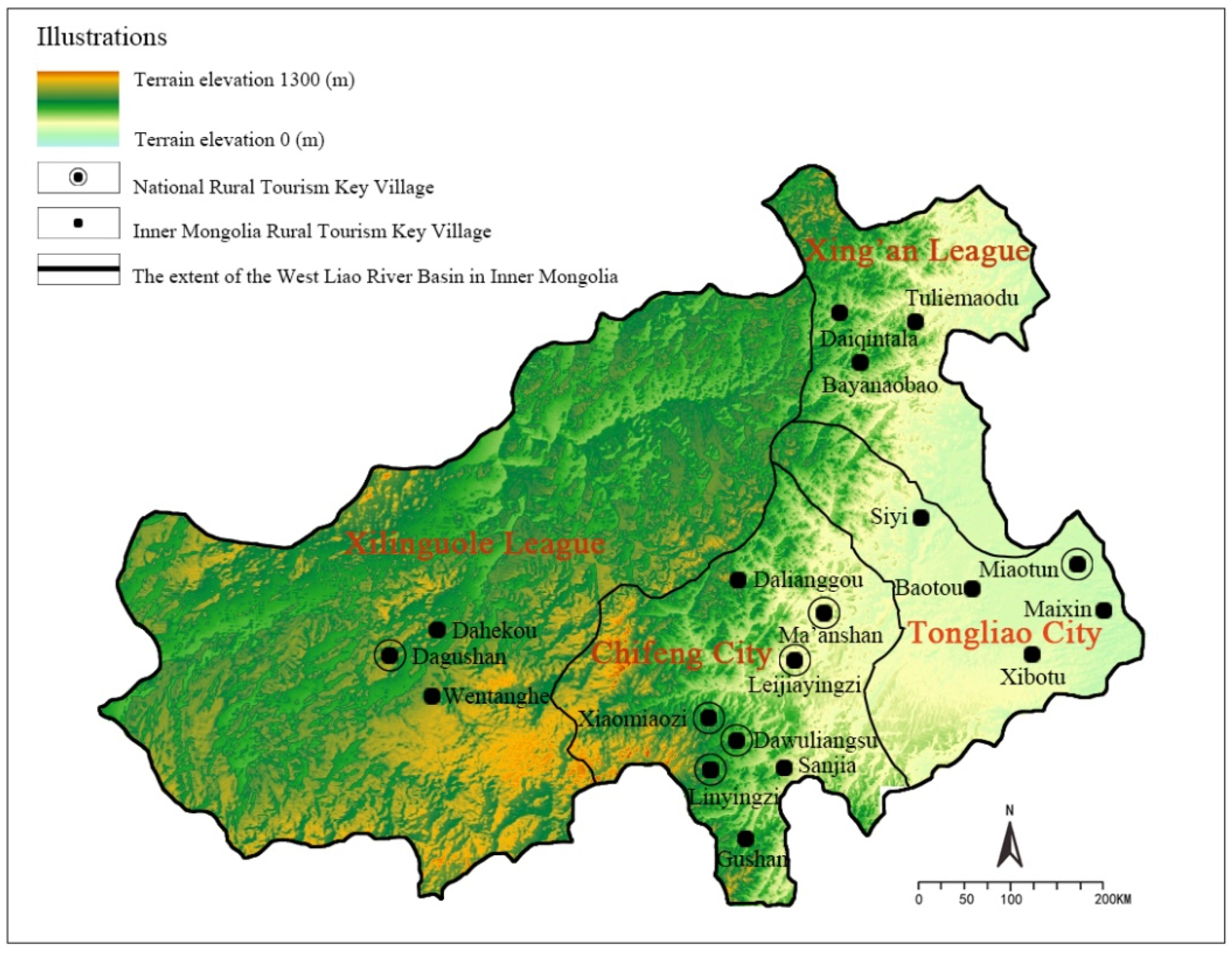
The rural areas in the Western Liao River Basin in Inner Mongolia are rural settlements where Han and Mongolian people gather, among which the rural settlements where Mongolian people gather are called Gacha [44]. Nineteen typical rural areas in four prefecture-level cities (seven Qis and counties) in the Western Liao River Basin in Inner Mongolia are used for the study, including eight in Chifeng City, five in Tongliao City, three in Xing’an League, and three in Xilinguole League. These rural areas are representative because they are different batches and grades of national rural tourism key rural areas and Inner Mongolia rural tourism key rural areas (see Table 1).
The topographical information and spatial distribution of the countryside are shown in Figure 2. The spatial distribution of rural areas in the Western Liao River Basin in Inner Mongolia is characterized by a significant large dispersion and small agglomeration. At the macro level, the Chifeng region in the south of the Western Liao River basin in Inner Mongolia is the main agglomeration area, with a very high-density value and a large distribution area. Secondly, the rural areas are mostly located in the Tongliao region in the east, forming a secondary agglomeration. At the micro-level, rural areas are mostly concentrated in Karachin Qi, Naiman Qi, Ke’erzhong Qi, and Duolun County.

5.2. Indicator System

5.2.1. Theoretical Basis of Index System Construction

(1) Policy and theoretical basis. In 2021, the General Office of the CPC Central Committee and the General Office of the State Council issued the Opinions on Strengthening the Preservation and Inheritance of History and Culture in Urban and Rural Construction [45]. The opinion points out that the top-level design of the system should be strengthened, and a system of urban and rural historical and cultural preservation and inheritance should be established with scientific classification, strong preservation, and effective management.
(2) Economic theory basis. Cobb–Douglas production function is a production function created by the American mathematician C.W. Cobb and economist Paul H. Douglas [46] when they jointly explored the relationship between inputs and outputs. In this paper, according to the Cobb–Douglas production function, labor, capital, and technology are integrated in the construction of the indicator system.

5.2.2. Indicator System Construction

There are some problems in the construction of the previous indicator system. First, the selection of indicators is mostly based on experience, has a lack of theoretical basis, especially the lack of national policy-oriented support; second, the selection of indicators is more one-sided and has a lack of systemic input indicators and output indicators selected in a less dimensional, less quantitative manner; third, only a focus is placed on preservation, ignoring how to revitalize the use and manage effectively; and fourth, only the preservation of strong and other expected outputs is consider, ignoring the destruction of demolition and other non-expected outputs.
In order to solve the practical problems in the construction of indicators, based on the deep study of the national policy on the preservation and inheritance of Chinese rural areas, the indicator system is constructed with the national policy as the guide and theoretical basis, so that the indicator system closely follows the requirements of the national policy and is more forward-looking and objective overall. At the same time, based on the reality development of rural preservation, the index system of assessing the value of Chinese rural preservation and inheritance, which contains 6 primary indicators, 12 secondary indicators, and 24 tertiary indicators, is constructed based on the principles of science, system, comprehensiveness, coordination, and operability, and seeks to assess the value of Chinese rural preservation and inheritance all-round with multi-perspectives, and the final index system is formed (see Table 2).
(1) Input indicators. According to the Cobb –Douglas production function, labor, capital, and technology are considered comprehensively. In terms of labor force, measured by the level of talent in a team, the number of leading cadres, technicians, and basic managers can reflect the level of talent in a team. In terms of capital, measured by preservation funds, the level of preservation funds can be reflected by financial and social funds. In terms of technology, since technological progress is a qualitative indicator, quantitative evaluation is more difficult. For this reason, the GML index is used, which can measure the degree of contribution of technological progress to the overall value assessment.
(2) Expected output indicators. It is structured according to two levels: strong preservation and effective management.
At the level of strong preservation, three aspects are used to measure the “promotion of revitalization and utilization, integration into rural construction, and promotion of history and culture”. The number of revitalized cultural heritage buildings, the number of revitalized agricultural cultural heritage and irrigation engineering heritage, and the number of revitalized intangible cultural heritage reflect the promotion of revitalized use; the number of supporting infrastructure and public service facilities reflects the integration into rural construction; and the number of historical and cultural display lines, corridors, networks, and cultural theme activities reflect the promotion of historical culture.
Effective management level is measured by five aspects: strengthening coordination, improving management mechanisms, promoting multi-participation, strengthening incentives, and strengthening supervision and inspection. The number of collaborative management departments and the number of cross-regional historical and cultural heritage preservation as a whole can reflect the strengthening of coordination; the number of optimized approval and management matters, the number of positive and negative lists of project access can reflect the sound management mechanism; the number of multi-participants can reflect the promotion of multi-participation; the number of publicity and promotion of typical cases, the number of rewarding organizations and individuals can reflect the strengthening of rewards and incentives; the number of inspections, regular the number of inspections, and regular evaluations can reflect the strengthening of supervision and inspection.
(3) Non-expected output indicators. It is structured according to two levels: ineffective preservation and ineffective management.
The number of old trees cut down, the number of rivers and lakes changed or encroached upon, and the number of old buildings and ancient houses demolished can reflect the destruction and demolition situation. Ineffective management is measured by assessment and accountability. Inclusion, in the endangered list and withdrawal from the preservation list, the number of punishments of responsible units and responsible persons can reflect the assessment of accountability.

5.3. Analysis of Results

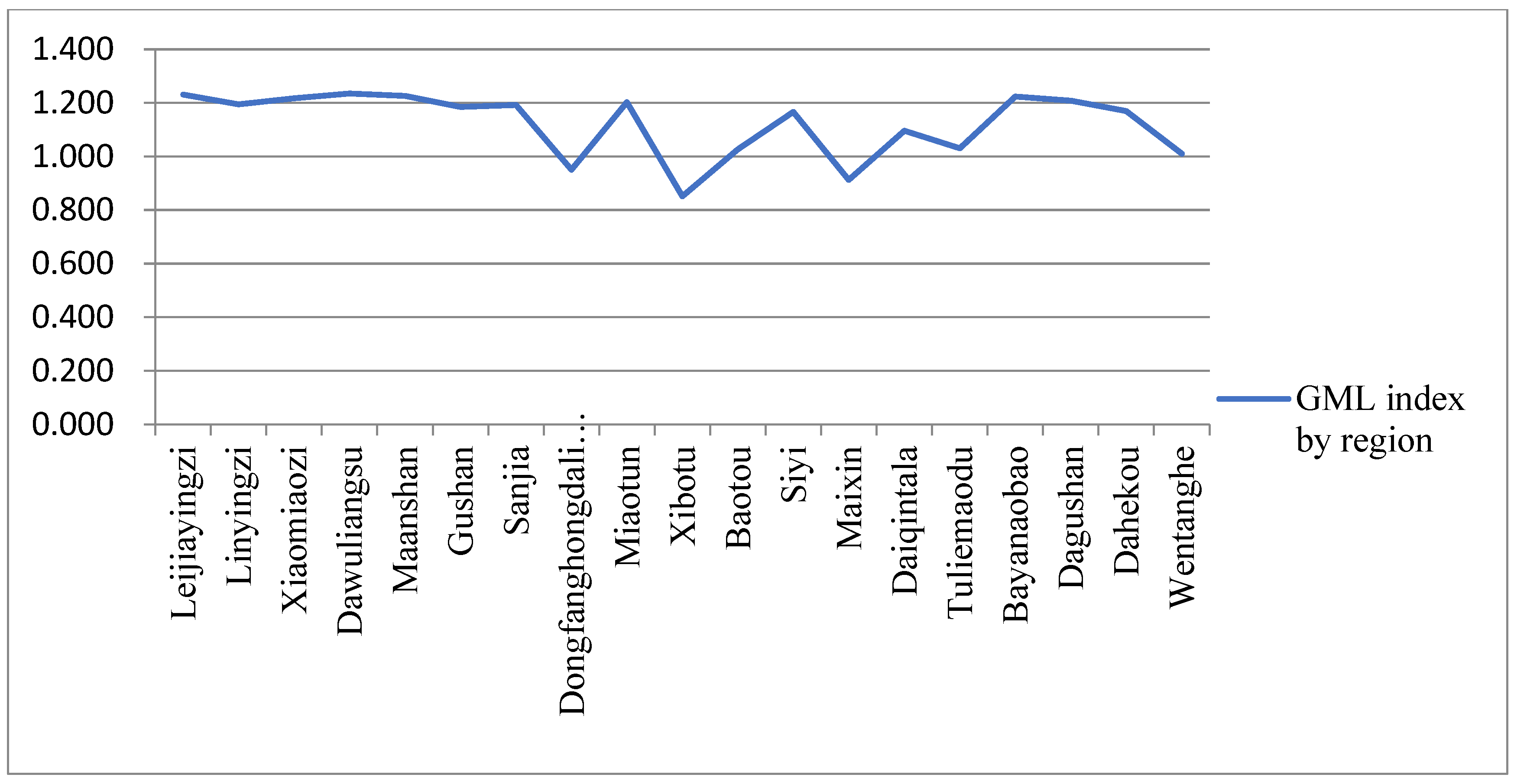
The aforementioned region-wide EBM-GML model was used to assess the preservation and inheritance value of rural areas in the Western Liao River Basin, Inner Mongolia, China, from 2019 to 2021. Additionally, Matlab software was used for mathematical modeling, and the results were obtained as follows (see Table 3, Figure 3 and Figure 4, Table 4, and Figure 5 and Figure 6, respectively).

5.3.1. Assessment Value Analysis

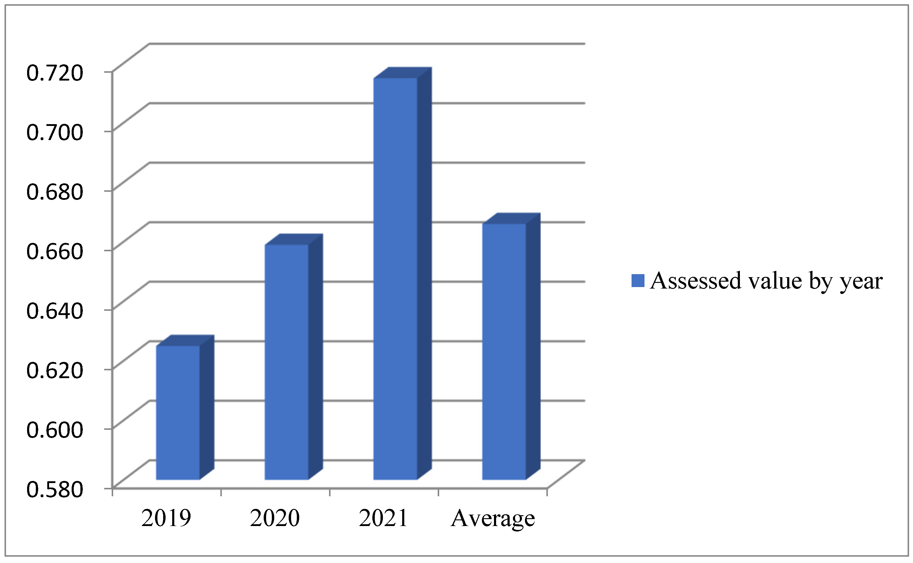
(1) Analysis by year. From Table 3 and Figure 1, it can be seen that the overall assessed value of rural preservation and inheritance in the Western Liao River Basin in Inner Mongolia, China, is 0.666 from 2019 to 2021, 0.625 in 2019, 0.659 in 2020, and 0.715 in 2021. The rate of increase in 2021 is faster than that of 2020, and the growth rate of assessed value increases year by year, with an average annual growth rate of 6.96% of assessed value.
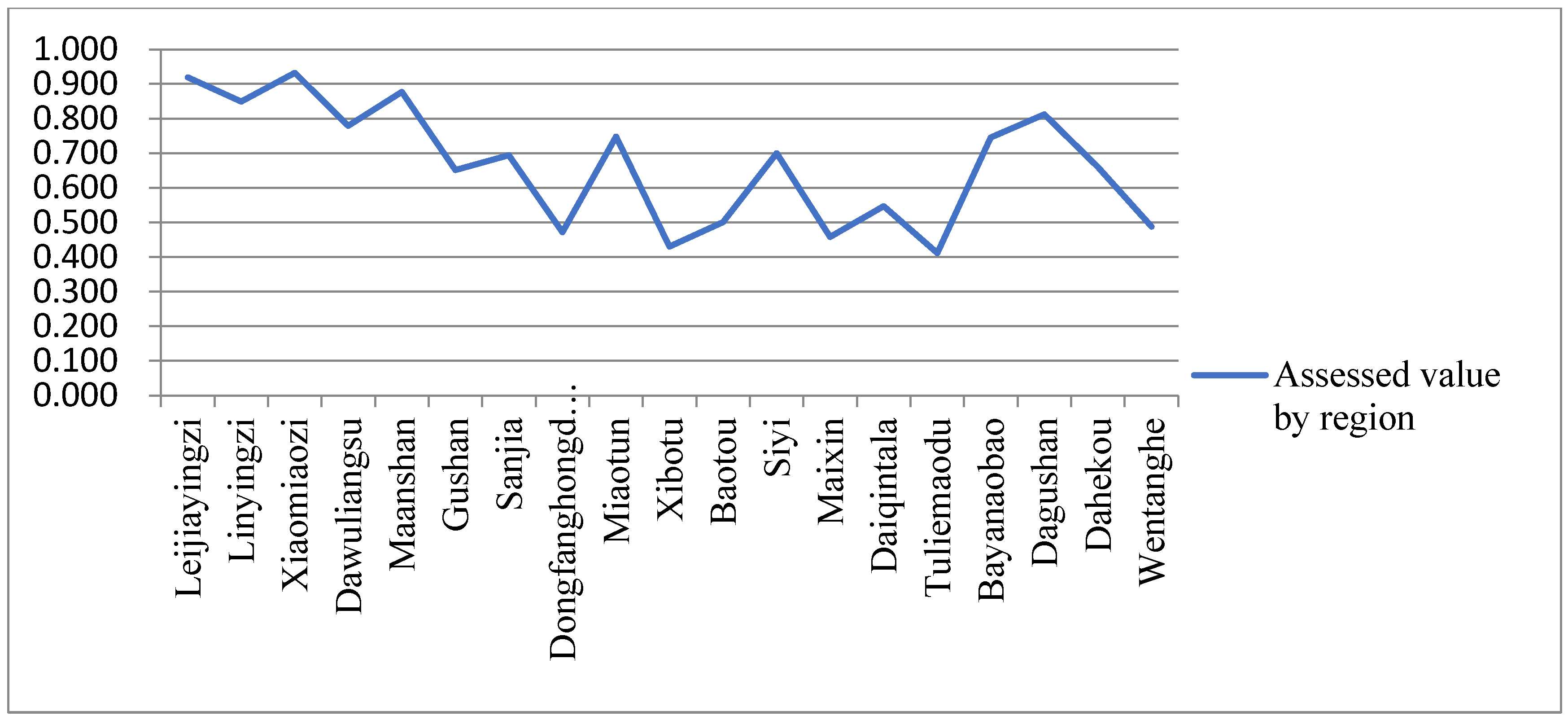
(2) Analysis by region. As can be seen from Table 3 and Figure 2, the top six rural areas in the assessment of the preservation and inheritance value of rural in the Western Liao River Basin, Inner Mongolia, China, in 2019–2021 are Xiaomiaozi, Leijiayingzi, Ma’anshan, Linyingzi, Dagushan, and Dawuliangsu; the middle seven rural areas are Miaotun, Bayanaobao, Siyi, Sanjia, Dahekou, Gushan, and Daiqintala; the last six rural areas are Baotou, Wentanghe, Dongfanghongdalianggou, Maixin, Xibotu, and Tuliemaodu. The average value of eight rural areas in Chifeng is 0.772, five rural areas in Tongliao is 0.567, three rural areas in Xing’an League is 0.568, and three rural areas in Xilinguole League is 0.653. It can be seen that rural areas in Chifeng generally perform better than rural areas in other cities in terms of heritage value assessment.
(3) Analysis of the dynamic trend of spatial and temporal evolution. From Table 3, it can be seen that from 2019 to 2021, the assessment of rural preservation and inheritance values in the Western Liao River Basin in Inner Mongolia, China, shows a “five-level differentiation trend”: seven rural areas increase at an accelerated rate; four rural areas increase at a decelerated rate; two rural areas decrease at a decelerated rate; one rural area decreases at an accelerated rate; and five rural areas show a fluctuating trend.
(4) Value assessment gap analysis. As can be seen from Table 3, the highest assessed value of 1 occurs in 2019–2021 for Xiaomiaozi and Leijiayingzi in 2021, and the lowest assessed value of 0.385 occurs in 2021 for Xibotu. The highest assessed value of 0.822 (Xiaomiaozi) and the lowest of 0.401 (Tuliemaodu) in 2019; the highest assessed value of 0.975 (Xiaomiaozi) and the lowest of 0.407 (Xibotu); the highest in 2021 was 1 (Leijiayingzi, Xiaomiaozi) and the lowest was 0.385 (Xibotu). It can be seen that the best performance of value assessment in all three years is concentrated in the Xiaomiaozi rural area. Xibotu and Tuliemaodu performed poorly. Meanwhile, it can be seen that the gap between the rural areas with the highest and lowest assessed values in the same year shows an increasing trend year by year from 2019 to 2021.

5.3.2. GML Index Analysis

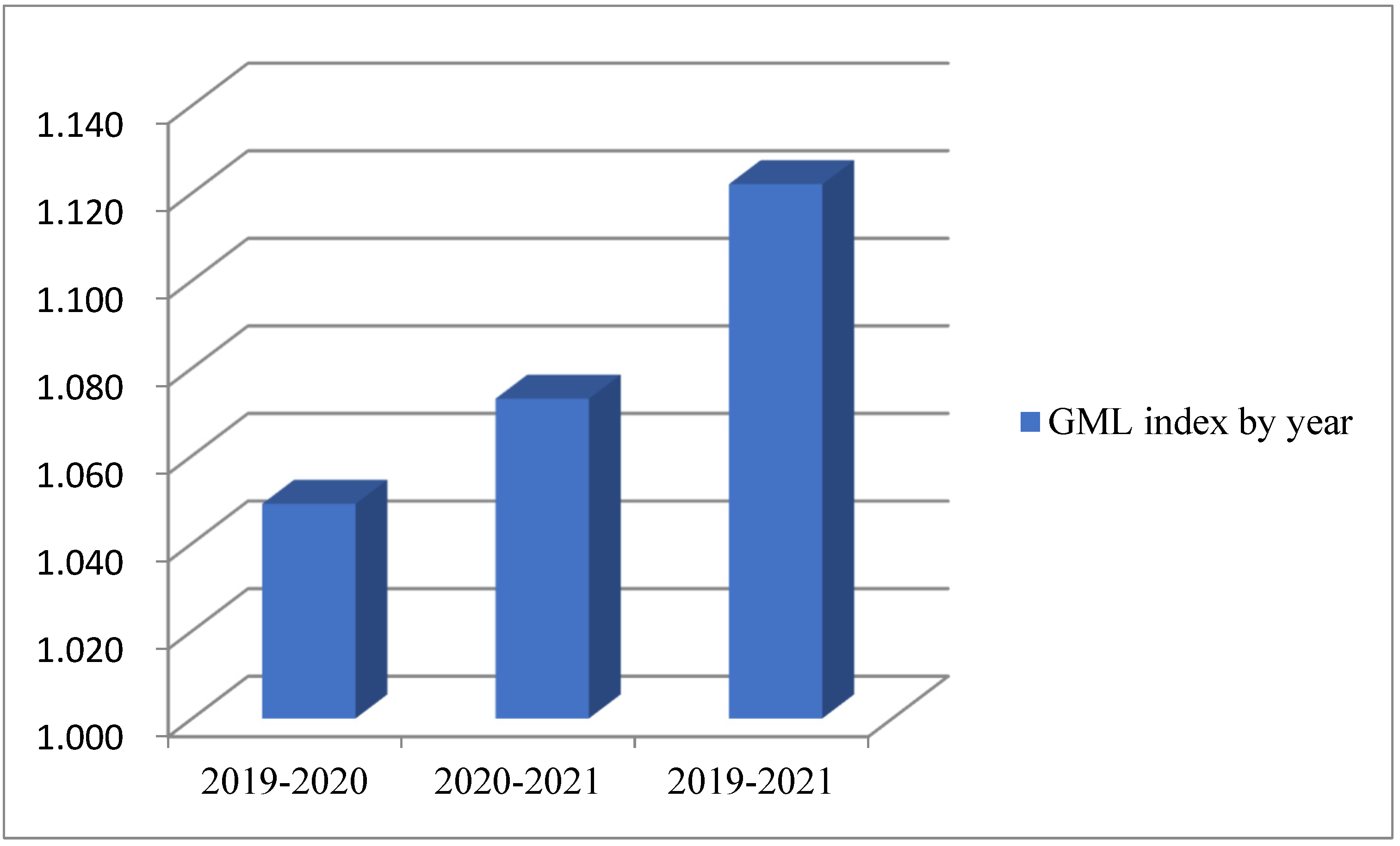
(1) Analysis by year. From Table 4 and Figure 3, it can be seen that the GML index for assessing the value of rural preservation and inheritance in the Western Liao River Basin, Inner Mongolia, China, is 1.122 in 2019–2021. Among which, the GML index is 1.049 in 2019–2020 and 1.073 in 2020–2021. It can be seen that the GML index shows an increasing trend over the past three years.
(2) Analysis by region. Combining Table 4 and Figure 4, it can be seen that in 2019–2021, the rural areas ranked at the top of the GML index of rural preservation and inheritance value assessment in the Western Liao River Basin in Inner Mongolia, China are Dawuliangsu, Leijiayingzi, Ma’anshan, Bayanaobao, Xiaomiaozi, and Dagushan; the rural areas ranked in the middle are Miaotun, Lingyingzi, Sanjia, Gushan, Dahekou, Siyi, and Daiqintala; the rural areas ranked last are Tuliemaodu, Baotou, Wentanghe, Dongfanghongdalianggou, Maixin, Xibotu.
(3) Spatial and temporal heterogeneity analysis. Based on the GML index, the assessment of the preservation and inheritance value of rural areas in the Western Liao River Basin in Inner Mongolia, China, can be classified into three types: continuous improvement type, fluctuating improvement type, and continuous decline type. Sanjia, Siyi, Tuliemaodu, Daiqintala, and Wentanghe belong to the fluctuating improvement type. Maixin, Dongfanghongdalianggou, and Xibotu belong to the continuous decline type. Other rural areas belong to the continuous improvement type.
(4) Technical progress analysis. The main contribution to the rise in the assessment of the preservation and inheritance value of Dawuliangsu, Leijiayingzi, Ma’anshan, Bayanaobao, Xiaomiaozi, and Dagushan rural areas is technological progress. Among them, Dawuliangsu, Leijiayingzi, and Ma’anshan have the highest technical progress.

6. Conclusions and Countermeasure Suggestions

By using the region-wide EBM-GML model to assess the preservation and inheritance value of rural areas in the Western Liao River Basin in Inner Mongolia, China, from 2019 to 2021, the following conclusions as well as targeted countermeasure suggestions are made.
(1) The overall preservation is improving year by year, and partly showing high preservation in the southwest and low preservation in the northeast.
The analysis of the specific index data and assessment results shows that the dynamic assessment value of most of rural is steadily increasing, whether overall rural preservation and inheritance or rural preservation and inheritance by year and region. This is due to the effective implementation of the national rural preservation and inheritance policy in the Western Liao River basin in Inner Mongolia.
However, due to the different resource endowments, location advantages, and stages of development of preservation and inheritance in different rural areas, the performance of preservation and inheritance is high in the southwest and low in the northeast. Chifeng is the largest city in the Western Liao River Basin in Inner Mongolia, and is located in the southern part of the Western Liao River Basin. As a high-density gathering area for rural areas, Chifeng exceeds other cities, whether because of the degree of spatial aggregation or the number of aggregations in the rural area. Therefore, it generally performs better than other municipalities in terms of rural preservation and inheritance. Xilinguole League is located in the western part of the Western Liao River Basin, and although it is not as numerous in terms of spatial aggregation as Tongliao, which is a sub-agglomeration, it has a higher overall assessment value than Tongliao City and Xing’an League in the eastern region due to its better resource endowment and earlier stage of development of rural preservation and inheritance. In order to solve the problem of regional differences, efforts should be made to achieve cross-administrative preservation and inheritance. On the one hand, the western and southern regions should continue to consolidate their achievements, innovate in the ways of preservation and inheritance, and enhance the radiation and driving effect of the eastern and northern regions. On the other hand, the eastern and northern regions should learn more from the advanced experience of the western and southern regions, and continue to improve the quality and efficiency of rural preservation and inheritance.
(2) The extreme difference values in assessment are increasing year by year, showing the Matthew effect.
Analysis of the assessment results shows that the difference between the rural areas with the highest and lowest assessed values in the same year has increased year by year, showing the Matthew effect. This indicates that there is a regional imbalance in value assessment and an increasing gap in assessed values. For this reason, we should adhere to the policy orientation, and strengthen co-ordinate planning and promotion. On the one hand, we should strengthen the overall preservation. We should integrate the preservation and inheritance of rural into the development of rural in the whole basin, so that the scope of revitalization and utilization can be made more extensive and deeper. At the same time, reduce non-expected outputs, such as destruction and demolition, to achieve the goal of strong preservation. On the other hand, the overall management is strengthened. At the management level, the management patterns for the preservation and inheritance of rural have been reformed to improve the effectiveness of the management of rural across the basin. At the same time, we will reduce non-expected outputs, such as punishment and accountability, to achieve the goal of effective management.
(3) Strengthening technical empowerment and scientific preservation and inheritance
From the assessment results, it is found that the overall reference GML index shows an increasing trend, indicating that the dynamic assessment value is gradually improving. The overall rural preservation and inheritance technology has made significant progress, of which Dawuliangsu, Leijiayingzi, Ma’anshan, Bayanaobao, Xiaomiaozi, and Dagushan rural areas have made significant technology progress in preservation and inheritance. Technology is the prerequisite for all efficiency and is a powerful tool to increase the value of rural preservation and inheritance. Therefore, in the rural preservation and inheritance, we should strengthen the technical empowerment, constantly learn advanced technological concepts, and transform technological achievements over time to achieve the scientific preservation and inheritance of the rural area.
Although some innovative results have been achieved, there are limitations in this study, which are reflected in the following aspects: 1. Research methods. (1) The need to make precise measurements of the characteristics of the cases makes it difficult to obtain in-depth information and easy to ignore the specific process of change. (2) Due to the complexity of the current situation of rural preservation and inheritance, it is difficult to accurately determine the causal relationship between the two variables. (3) Rural preservation and inheritance in China have a certain specificity, and it is impossible to draw generalizations, so it is impossible to rely on quantitative analysis completely. 2. Accuracy of data. Due to the large time span of the panel data, the study has partially missing data and completely missing data, resulting in insufficient accuracy of the data. 3. Analysis strategy. There is a problem of subjective bias in the investigation process based on the pre-prepared ideas. 4. Representativeness of the case study sites. The Western Liao River Basin in Inner Mongolia is chosen as a case study site, which is not very representative from the level of economic advantages due to some economic conditions gaps with developed areas. It is expected to be further improved and enhanced in the future.

Author Contributions

Conceptualization, J.L. (Jiajing Li) and J.L. (Jianing Li); methodology, J.L. (Jianing Li); software, J.L. (Jianing Li); validation, J.L. (Jiajing Li); formal analysis, J.L. (Jiajing Li) and J.L. (Jianing Li); investigation, J.L. (Jiajing Li); resources, P.Z.; data curation, J.L. (Jiajing Li) and J.L. (Jianing Li); writing-original draft preparation, J.L. (Jianing Li); writing-review and editing, J.L. (Jiajing Li); visualization, J.L. (Jiajing Li) and J.L. (Jianing Li); supervision, P.Z.; project administration, P.Z.; funding acquisition, P.Z. All authors have read and agreed to the published version of the manuscript.

Funding

This research was funded by [Research on Local Knowledge Mapping and Planning Application Strategies of Traditional Rural in Qinba Mountains] grantnumber [No. 19YJAZH107] And The APC was funded by [Humanities and Social Sciences Research Planning Fund, Ministry of Education, China].

Data Availability Statement

As the data involves three years of local policies, management, financial audits, participation of multiple interest subjects, and other more sensitive information, it is internal information and cannot be made public according to local requirements.

Conflicts of Interest

The authors declare no conflict of interest.

References

  1. Li, X. Research on the Lisving Preservation and Development of Xinbaozi Rural in Huludao City under the Strategy of Rural Revitalization. Master’s Thesis, Shenyang Jianzhu University, Shenyang, China, 2022; p. 13. [Google Scholar] [CrossRef]
  2. Lu, Q. Research on the Wisdom of Cultural Space Construction and Preservation and Inheritance of Traditional Rurals along the Yellow River in Shaanxi. Master’s Thesis, Xi’an University of Architecture and Technology, Xi’an, China, 2022; pp. 24–25. [Google Scholar] [CrossRef]
  3. Hu, J. The dilemma and the way out of the construction of non-heritage cultural preservation system in the context of rural revitalization strategy. Cult. Geogra 2023, 2, 61–64. [Google Scholar]
  4. Yang, X. Study on the change of habitat and living heritage strategy of traditional rurals in the Qiantang River Basin. Acad. Beijing China 2022, 34–35. [Google Scholar] [CrossRef]
  5. Jiang, Z. Current thinking on the preservation of rural cultural heritage and the development of creative industries. Cult. Forum 2022, 12, 86–95. [Google Scholar]
  6. Burchardt, J. State and Society in the English Rural: The Rural Community Movement 1918–39. Rural Hist. 2012, 23, 56–67. [Google Scholar] [CrossRef]
  7. Mulder, J.; Brent, A.C. Selection of Sustainable Rural Agriculture Projects in South Africa: Case Studies in the Land Care Programme. J. Sustain. Agric. 2006, 28, 22–24. [Google Scholar] [CrossRef]
  8. Lynn, M. The Return of Community to Rural Human Services. Rural Soc. 2004, 14, 13–15. [Google Scholar] [CrossRef]
  9. Liu, P. Research on the Development and Utilization of Hunan Rural Cultural Landscape Resources in the Construction of New Rural; Hunan Forum on Building a New Socialist Countryside: Changsha, China, 2006; pp. 12–13. [Google Scholar]
  10. Liu, Q. The preservation and inheritance of intangible cultural heritage in China from the perspective of Marxist cultural outlook. Univ. Guangzhou China 2019, 23–24. [Google Scholar] [CrossRef]
  11. Tovey, H. Introduction: Rural Sustainable Development in the Knowledge Society Era. Sociol. Rural. 2008, 48, 185–199. [Google Scholar] [CrossRef]
  12. Káposzta, J.; Nagy, H. The Major Relationships in the Economic Growth of rural Space. Eur. Ctry. 2022, 14, 67–86. [Google Scholar] [CrossRef]
  13. Parlato, M.C.; Valenti, F.; Porto, S.M. Sustainable Promotion of Traditional Rural Buildings as Built Heritage Attractions: A Heritage Interpretation Methodology Applied in South Italy. Sustainability 2022, 14, 16206. [Google Scholar] [CrossRef]
  14. Khamung, R. The Investigation of Rural Cultural Heritage and Implications to Agritourism Strategies for Preservation in Rural Chiangkhan, Thailand. J. Tour. Leis. Stud. 2016, 1, 13–36. [Google Scholar] [CrossRef]
  15. Heaphy, L.; Scott, M. Path dependence, ‘lock-in’ and rural housing outcomes: Insights from Ireland. Eur. Plan. Stud. 2022, 30, 2412–2432. [Google Scholar] [CrossRef]
  16. Hu, M.; Dong, W. Study on the application of GIS technology in the preservation planning of historical districts. Archit. Sci. 2004, 12, 63–65. [Google Scholar]
  17. Liu, C.; Liu, P. Research on the preservation and development of ancient rurals in the context of economic construction in the mountainous regions of Beijing. Econ. Geogra 2011, 31, 1923–1929. [Google Scholar]
  18. Hu, B. The current situation of traditional rural evolution is worrying—A survey and return visit from the front line of rural areas. People Forum 2015, 14, 3. [Google Scholar]
  19. Feng, G.; Sun, Y. My cultural preservation is also an emotional act. Cult. Forum 2018, 248, 109–114. [Google Scholar]
  20. Rolínek, L.; Cudlínová, E.; Klufová, R.; Leitmanová, I.F.; Jílek, M.; Řehoř, P. Model strategy for village development in the Czech Republic. J. Cent. Eur. Agric. 2015, 16, 88–90. [Google Scholar] [CrossRef]
  21. Nugraha, L.F.; Sulistyowati, L.; Setiawan, I.; Noor, T.I. Alternative Community-Based Rural Development Strategies in Indonesia:Using Multicriteria Decision Analysis. Agriculture 2022, 12, 1903. [Google Scholar] [CrossRef]
  22. Kusrini, E. Strategy of Tourist Rural Development in Nongkosawit Sub-District, Gunungpati District, Semarang City. Econ. Dev. Anal. J. 2018, 6, 46–48. [Google Scholar]
  23. Bérczi, S.; Szabó, Z.; Sallay, Á. Strategic Directions:Evaluation of Rural Development Strategies in the Case of Applicants for the Hungarian Rural Renewal Award. Land 2022, 11, 681. [Google Scholar] [CrossRef]
  24. Kumar, A. Rural Development Practice and History in Ghana and India: Some Comments. Community. Int. J. Community Soc. Dev. 2022, 4, 12–14. [Google Scholar] [CrossRef]
  25. Ruan, Y. A long way to go for heritage preservation. Rural Cult. 2004, 34, 6–8. [Google Scholar]
  26. Zhao, Y.; Wang, J. Research on traditional rural settlement planning based on morphological integrity—The application of settlement performance enhancement planning techniques. Urban Plan 2018, 42, 33–40. [Google Scholar]
  27. Xie, H. Research on the spatially adaptive development model of rural rurals in the northern Qinling Mountains. Univ. Xi’an China 2017, 12, 3–25. [Google Scholar]
  28. Xie, H. A preliminary study on the ecological adaptive development model of rural space in shallow mountainous areas at the edge of the City. Archit. Sci. 2022, 54, 95–102. [Google Scholar]
  29. Guo, Y.; Yao, Y.; Li, G. Spatial strategies for reshaping rural comfort with greenway networks:the case of Zhenjiang Town. Archit. Sci. 2022, 54, 76–84. [Google Scholar]
  30. Wu, F.; Liao, Y.; Wu, X. Study on the spatial development of rural settlements at the southern foot of the Qinling Mountains based on the definition of small watersheds. Archit. Sci. 2018, 50, 249–257. [Google Scholar]
  31. Hodge, I.; Midmore, P. Models of rural development and approaches to analysis evaluation and decision-making. Économie Rural. 2008, 3, 23–38. [Google Scholar] [CrossRef]
  32. Nemes, G. Integrated Rural Development-The Concept and Its Operation; Bright Publishers: New York, NY, USA, 2005; Volume 34, pp. 21–22. [Google Scholar]
  33. Díez, M.A.; Izquierdo, B.; Malagón, E. Increasing the Use of Evaluation through Participation: The experience of a rural sustainable development plan evaluation. Environ. Policy Gov. 2016, 26, 33–35. [Google Scholar] [CrossRef]
  34. Prus, B.; Wilkosz-Mamcarczyk, M.; Salata, T. Landmarks as Cultural Heritage Assets Affecting the Distribution of Settlements in Rural Areas—An Analysis Based on LIDAR DTM, Digital Photographs, and Historical Maps. Remote Sens. 2020, 12, 1778. [Google Scholar] [CrossRef]
  35. Li, Y.T.; Tian, L.; Zhao, L. Research on the value assessment of traditional rurals in Beijing and their preservation strategies based on K-modes. Town Constr. 2019, 37, 22–29. [Google Scholar]
  36. Tian, J.; Jiang, Q. Research on regional survey methods and evaluation system of traditional wind and landscape rurals and towns--a survey of traditional wind and landscape rurals and towns in Kunming City as an example. Town Constr. 2016, 12, 27–32. [Google Scholar]
  37. Liu, Z. Study on the evaluation of the value of Chinese traditional rurals as world cultural heritage. Soc. Sci. 2021, 42, 52–58. [Google Scholar]
  38. Beckmann, M.J.; Charnes, A. An Introduction to Linear Programing; Charnes, A., Cooper, W.W., Henderson, A., Eds.; Macmillan Publishers: London, UK, 1954; Volume 62, pp. 13–15. [Google Scholar]
  39. Charnes, A.; Cooper, W.W.; Rhodes, E. Evaluating Program and Managerial Efficiency: An Application of Data Envelopment Analysis to Program Follow Through. Manag. Sci. 1981, 27, 30–31. [Google Scholar] [CrossRef]
  40. Tone, K. A slacks-based measure of efficiency in data envelopment analysis. Eur. J. Oper. Res. 2001, 130, 12–13. [Google Scholar] [CrossRef]
  41. Kumar, S. Environmentally sensitive productivity growth: A overall analysis using Malmquist-Luenberger index. Ecol. Econ. 2006, 56, 34–36. [Google Scholar] [CrossRef]
  42. Inner Mongolia Bureau of Statistics. Inner Mongolia Statistical Yearbook 2022; Beijing, China. 2022; pp. 12–14. Available online: http://tj.nmg.gov.cn/files_pub/content/PAGEPACK/83e5521da4e94d50ab45483b58e5fa7e/indexch.htm?slh=true (accessed on 9 April 2023).
  43. Department of Water Resources of Inner Mongolia. Inner Mongolia Water Conservancy Yearbook (2021); Beijing, China. 2021, pp. 24–26. Available online: http://www.nmgqq.com.cn/xinxidongtai/gongzuodongtai/qunei/2022-12-31/25702.html (accessed on 9 April 2023).
  44. Office of the People’s Government of Balinzuo Qi. Yearbook of Balinzuo Qi 2021; Chinese Literature and History Press: Beijing, China, 2021; pp. 54–55. Available online: http://product.dangdang.com/11160590691.html (accessed on 9 April 2023).
  45. Central Office and the State Office. Opinions on Strengthening the Preservation and Inheritance of History and Culture in Urban and Rural Construction; Central Office and the State Office: Beijing, China, 2021; Volume 11, p. 3. [Google Scholar]
  46. Cobb, C.W.; Douglas, P.H. A Theory of Production. Am. Econ. Rev. 1928, 18, 12–13. [Google Scholar]
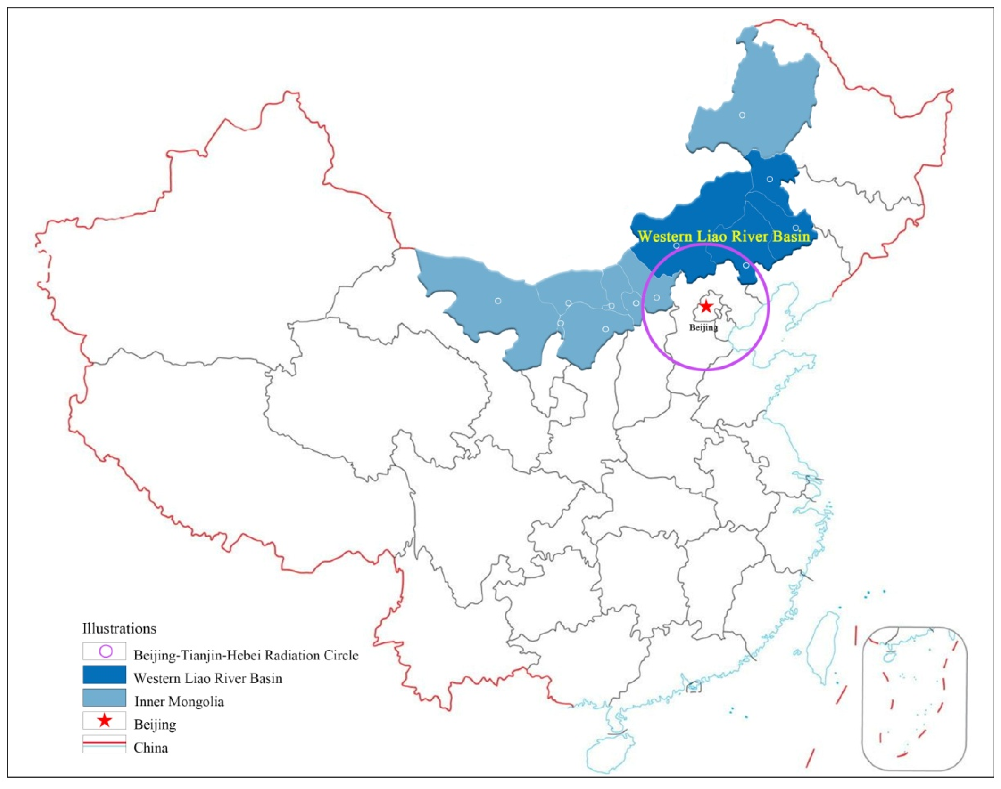
Figure 1. Location map of the Western Liao River Basin in Inner Mongolia.
Buildings 13 01104 g001
Figure 2. Topographical information and location of rural areas in the Western Liao River Basin, Inner Mongolia.
Buildings 13 01104 g002
Figure 3. Value assessment of rural preservation and inheritance in the Western Liao River Basin, Inner Mongolia, China, by year.
Buildings 13 01104 g003
Figure 4. Value assessment of rural preservation and inheritance sub-regions in the Western Liao River Basin, Inner Mongolia, China.
Buildings 13 01104 g004
Figure 5. GML index of rural preservation and inheritance value assessment by year in the Western Liao River Basin, Inner Mongolia, China.
Buildings 13 01104 g005
Figure 6. GML index of rural preservation and inheritance value assessment by region in the Western Liao River Basin, Inner Mongolia, China.
Buildings 13 01104 g006
Table 1. List of key villages for rural tourism in different batches and grades in the Western Liao River Basin, Inner Mongolia, China.
ProvinceCityVillage NameYear/BatchGradeRating Status
Inner MongoliaChifengLeijiayingzi Village, Xiqiao Town, Kalaqin Qi2019/1NationalRural tourism key villages
Lingyingzi Village, Shixiang Town, Kalaqin Qi2020/2National
Xiaomiaozi Village, Daimiao Town, Songshan District2021/3National
Dawuliangsu Village, Laofu Town, Songshan District2022/4National
Ma’anshan Village, Henan Street, Kalaqin Qi2022/4National
Gushan Village, Meilin Town, Kalaqin Qi2021/1Inner Mongolia
Sanjia Village, Wangfu Town, Kalaqin Qi2022/2Inner Mongolia
Dongfang Hong Daliangou Village, Biliutai Town, Balinzuo Qi2022/2Inner Mongolia
TongliaoMiaotun Village, Bayintala Sumu, Naiman Qi2020/2National
Xibotu Village, Bayintala Sumu, Naiman Qi2021/1Inner Mongolia
Baotou Gacha, Baiyintala Sumu, Naiman Qi2021/1Inner Mongolia
Siyi Village, Qinglongshan Town, Naiman Qi2022/2Inner Mongolia
Maixin Village, Maixin Town, Kailu County2022/2Inner Mongolia
Xing’anDaiqintala Gacha, Daiqintala Sumu, Ke’right Central Qi2021/1Inner Mongolia
Tuliemaodu Gacha, Tuliemaodu Town, Keyouzhong Qi2021/1Inner Mongolia
Bayanaobao Gacha, Emmuting Gaol Sumu, Keyouzhong Qi2022/2Inner Mongolia
XilinguoleDagushan Village, Luanyuan Town, Duolun County2020/2National
Dahekou Village, Luanyuan Town, Duolun County2021/1Inner Mongolia
Wentanghe Village, Luanyuan Town, Duolun County2021/1Inner Mongolia
Table 2. Index system for assessing the value of preservation and inheritance in Chinese rural areas.
IndicatorsTier 1 IndicatorsSecondary IndicatorsTertiary Indicators
Input IndicatorsWorkforceTalent Team LevelNumber of leaders (numbers)
Number of technical staff and basic management (numbers)
CapitalPreservation fundsFinancial funds (million yuan)
Social funds (million yuan)
Expected Output IndicatorsStrong preservationPromote the revitalization of utilizationNumber of revitalized and utilized heritage buildings(numbers)
Number of revitalized and utilized agricultural cultural heritage and irrigation engineering heritage (numbers)
Number of revitalized and utilized intangible cultural heritage (numbers)
Integration into rural constructionNumber of supporting infrastructure and public service facilities (numbers)
Promotion of historical and cultural situationNumber of historical and cultural display lines, corridors, and networks (numbers)
Number of cultural theme activities (times)
Effective managementStrengthen the coordination of the situationNumber of co-management departments (numbers)
Number of overall preservations of historical cultural heritage across the region(numbers)
Situation of sound management mechanismOptimize the number of matters for approval and management (items)
Number of positive and negative lists of project access (numbers)
Promoting multi-stakeholder engagementNumber of multi-participant subjects(numbers)
Reinforcing the incentive situationNumber of typical cases of publicity and promotion (numbers)
Number of rewarding organizations and individuals (numbers)
Strengthen the supervision and inspection situationNumber of inspections (times)
Number of periodic assessments (times)
Non-expected output indicatorsInadequate preservationDestruction and demolitionNumber of old trees cut down (trees)
Number of alterations or encroachments on rivers and lakes(numbers)
Number of old buildings and ancient dwellings demolished (numbers)
Ineffective managementAssessment accountabilityNumber of listed as endangered and withdrawn from the preservation list (numbers)
Number of responsible units and responsible persons punished (numbers)
Table 3. Rank of the assessment of the preservation and inheritance value of rural areas in the Western Liao River Basin, Inner Mongolia, China.
Serial NumberRural NameCity of Affiliation201920202021Average
Value
RankType
1LeijiayingziChifeng0.8120.9461.0000.9192Decelerated ascent
2LinyingziChifeng0.7920.8100.9450.8494Accelerated ascent
3XiaomiaoziChifeng0.8220.9751.0000.9321Decelerated ascent
4DawuliangsuChifeng0.7090.7510.8760.7796Accelerated ascent
5Ma’anshanChifeng0.8050.8380.9870.8773Accelerated ascent
6GushanChifeng0.6080.6240.7210.65112Accelerated ascent
7SanjiaChifeng0.6620.6300.7890.69410Fluctuating
8DalianggouChifeng0.4810.4630.4570.47216Decelerated decline
9MiaotunTongliao0.6830.7410.8210.7487Accelerated ascent
10XibotuTongliao0.4520.4070.3850.43018Decelerated decline
11BaotouTongliao0.4930.5030.5060.50114Decelerated ascent
12SiyiTongliao0.6740.6420.7850.7009Fluctuating
13MaixinTongliao0.4780.4610.4360.45817Accelerated decline
14DaiqintalaXing’an 0.5330.5230.5840.54713Fluctuating
15TuliemaoduXing’an 0.4010.4210.4130.41219Fluctuating
16BayanaobaoXing’an 0.6720.7410.8220.7458Accelerated ascent
17DagushanXilinguole0.7300.8250.8820.8125Decelerated ascent
18DahekouXilinguole0.6130.6510.7170.66011Accelerated ascent
19WentangheXilinguole0.4460.5670.4510.48815Fluctuating
Average 0.6250.6590.7150.666
Table 4. GML index for assessing the value of rural preservation and inheritance in the Western Liao River Basin, Inner Mongolia, China.
Serial NumberRural NameCity of Affiliation2019–20202020–20212019–2021Rank
1LeijiayingziChifeng1.1651.0571.2312
2LinyingziChifeng1.0231.1671.1948
3XiaomiaoziChifeng1.1861.0261.2175
4DawuliangsuChifeng1.0591.1661.2351
5Ma’anshanChifeng1.0411.1781.2263
6GushanChifeng1.0261.1551.18510
7SanjiaChifeng0.9521.2521.1929
8DalianggouChifeng0.9630.9870.9517
9MiaotunTongliao1.0851.1081.2027
10XibotuTongliao0.90.9460.85119
11BaotouTongliao1.021.0061.02615
12SiyiTongliao0.9531.2231.16612
13MaixinTongliao0.9640.9460.91218
14DaiqintalaXing’an 0.9811.1171.09613
15TuliemaoduXing’an 1.050.9811.0314
16BayanaobaoXing’an 1.1031.1091.2234
17DagushanXilinguole1.131.0691.2086
18DahekouXilinguole1.0621.1011.16911
19WentangheXilinguole1.2710.7951.0116
Average 1.0491.0731.122
Disclaimer/Publisher’s Note: The statements, opinions and data contained in all publications are solely those of the individual author(s) and contributor(s) and not of MDPI and/or the editor(s). MDPI and/or the editor(s) disclaim responsibility for any injury to people or property resulting from any ideas, methods, instructions or products referred to in the content.