
Spatial Distribution and Influencing Factors of Traditional Villages in Inner Mongolia Autonomous Region

Abstract
:1. Introduction
2. Research Area Overview, Data Sources and Research Methods
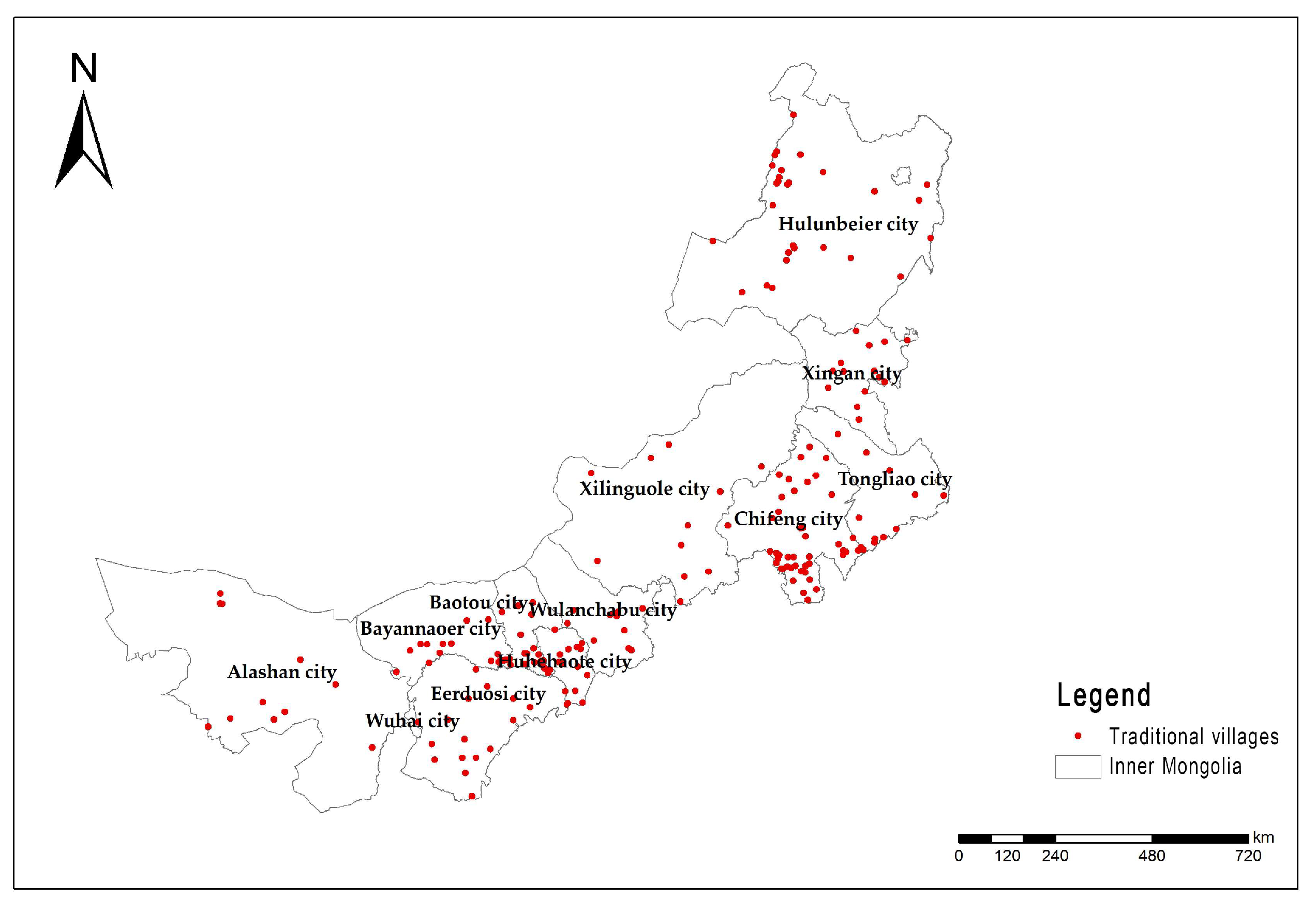
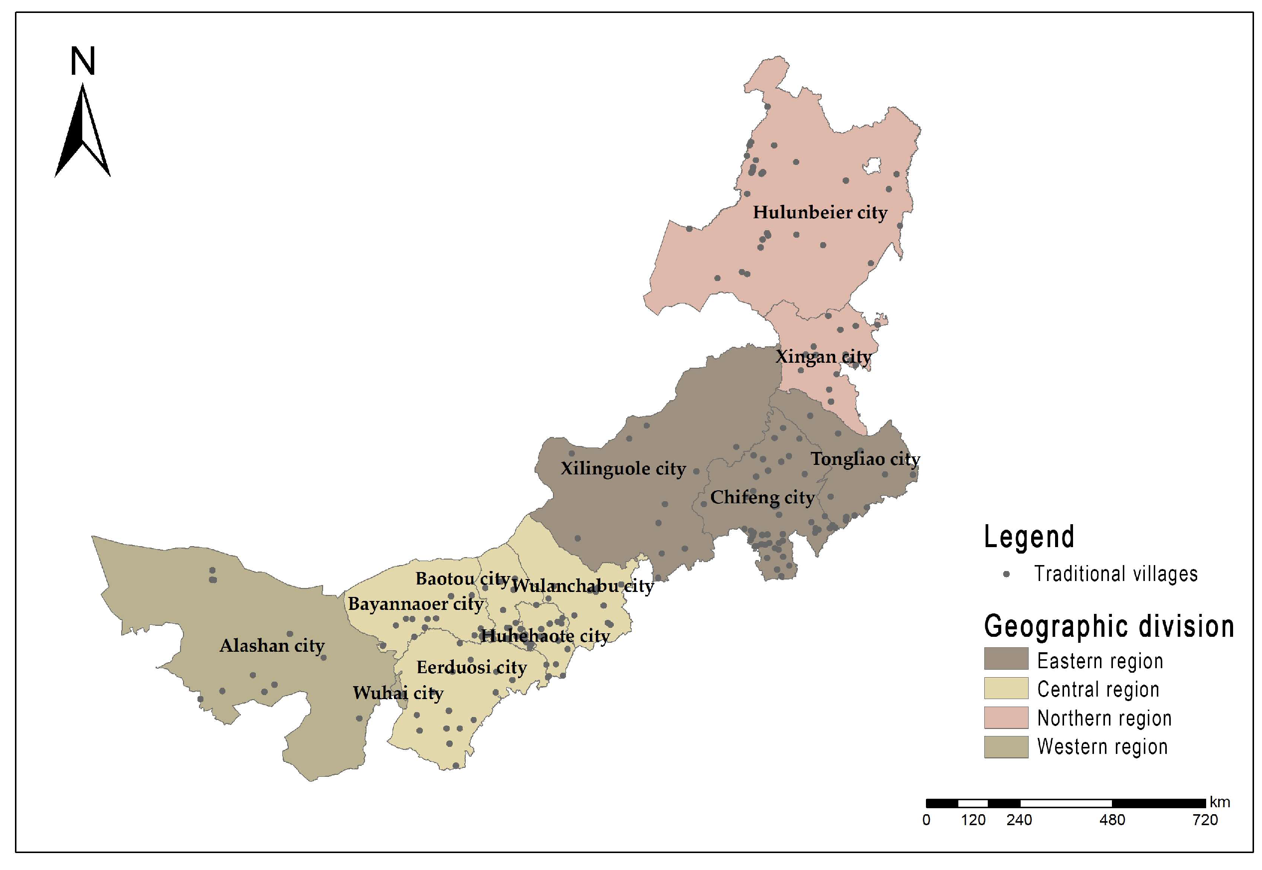
2.1. Overview of Study Area
2.2. Data Sources
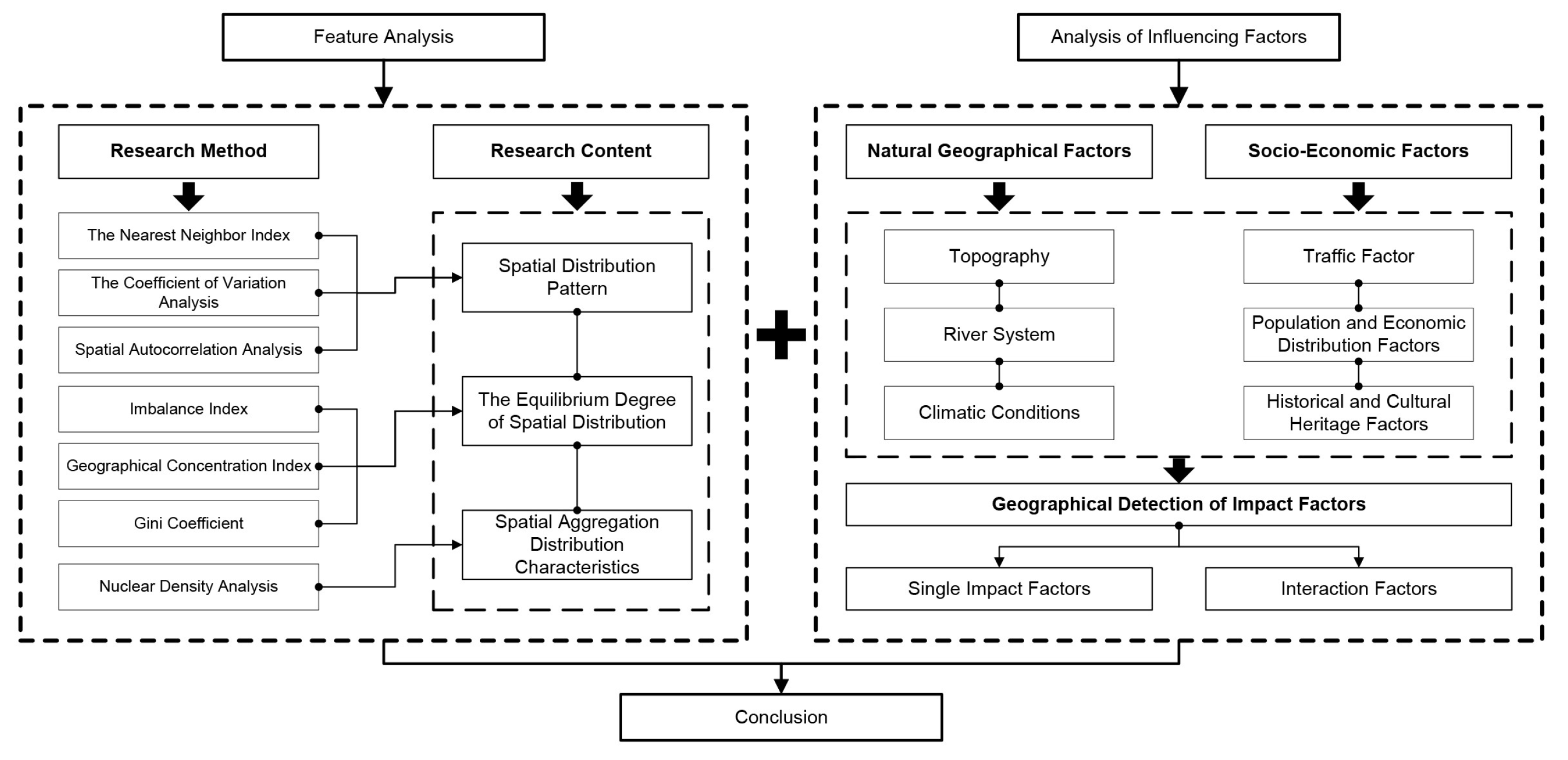
2.3. Research Method
3. Spatial Distribution Characteristics
3.1. Spatial Distribution Pattern
3.1.1. The Nearest Neighbour Index Analysis
3.1.2. The Coefficient of Variation Analysis
3.1.3. Spatial Autocorrelation Analysis
3.2. The Equilibrium Degree of Spatial Distribution
3.2.1. Analysis of Overall Equilibrium Degree
3.2.2. Geographical Concentration Index Analysis
3.2.3. Gini Coefficient Analysis
3.3. Spatial Aggregation Distribution Characteristics
4. Influencing Factors of Spatial Distribution
4.1. Natural Geographical Factors
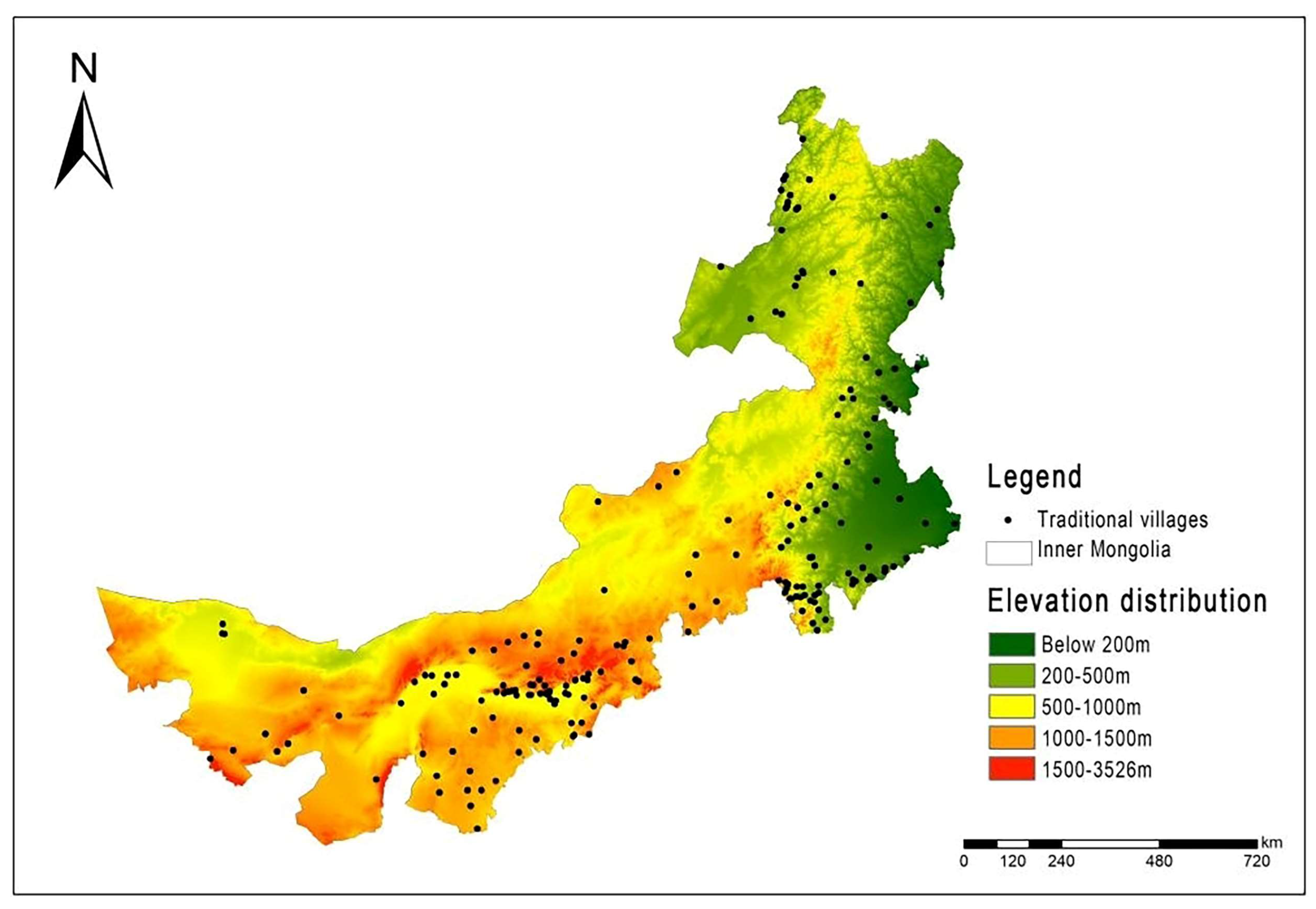
4.1.1. Topography
- Elevation
- 2.
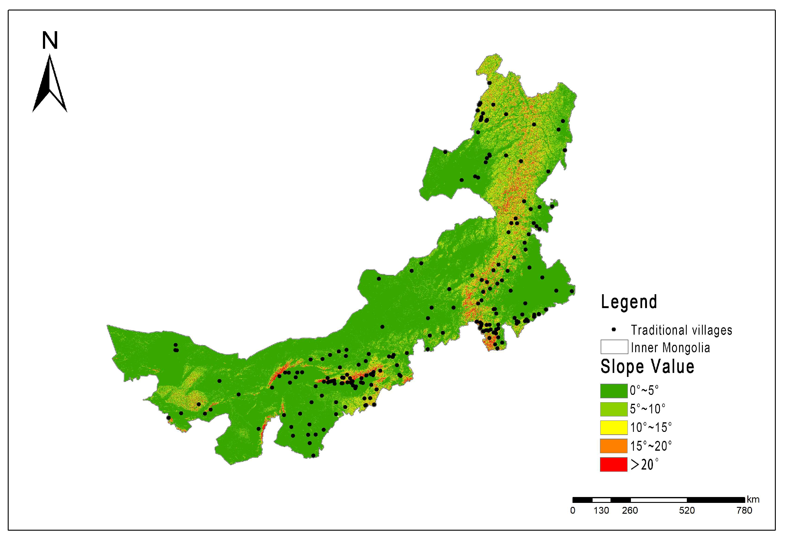
- Slope Value
- 3.
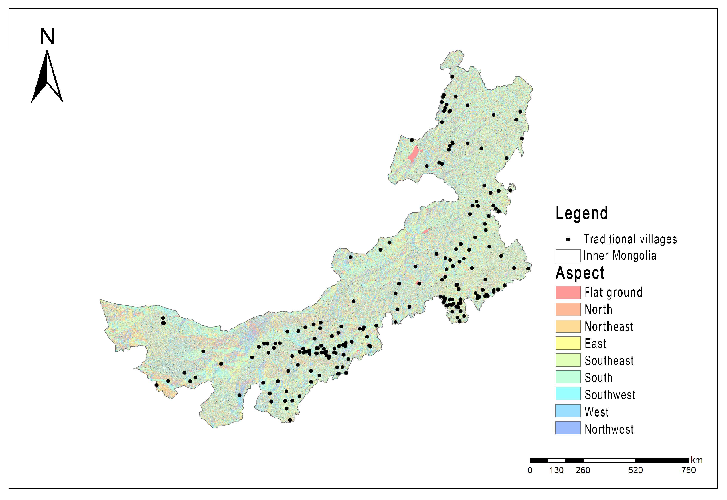
- Slope Aspect
4.1.2. River System
4.1.3. Climatic Conditions
4.2. Socio-Economic Factors
4.2.1. Traffic Factor
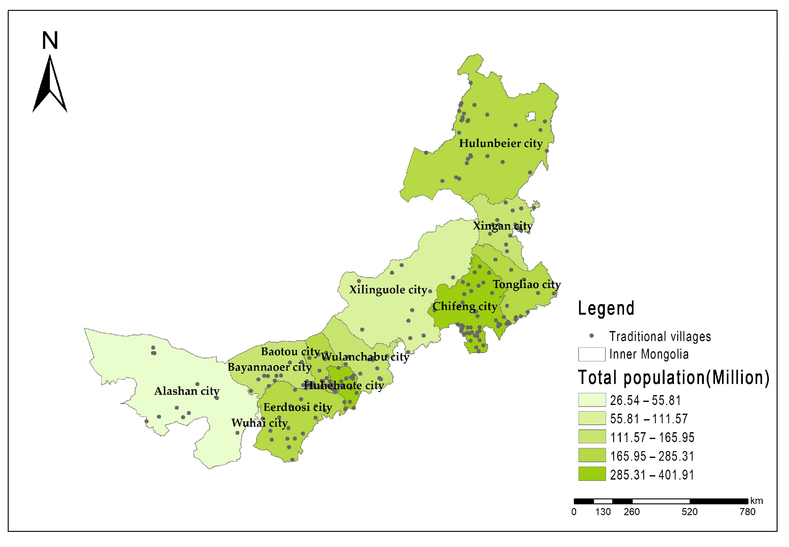
4.2.2. Population and Economic Distribution Factors
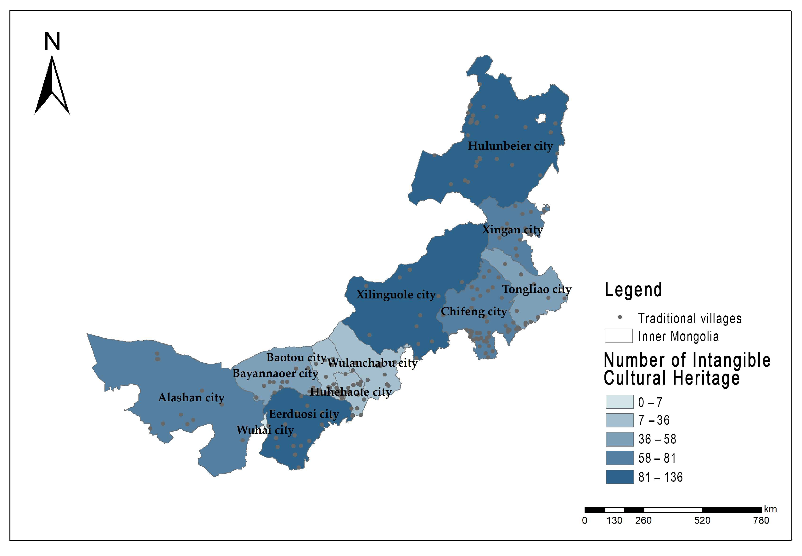
4.2.3. Historical and Cultural Heritage Factors
5. Geographical Detection of Impact Factors
5.1. Single Impact Factors Detection
5.2. Interaction Influence Factors Detection
6. Discussion
6.1. Natural Environmental Factors as the Foundation of Traditional Village Spatial Distribution
6.2. Socio-Economic Factors as the Core of Traditional Village Spatial Distribution
6.3. Future Development Vision of Traditional Villages in Inner Mongolia
7. Conclusions
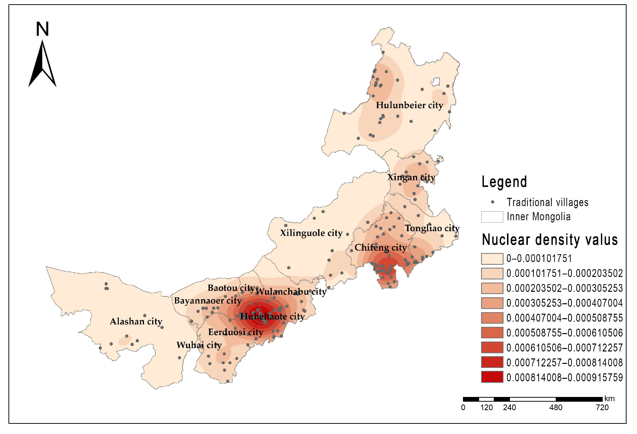
- Through the nearest neighbor point index, the coefficient of variation analysis, spatial autocorrelation analysis, and kernel density analysis, it can be seen that the traditional villages in Inner Mongolia belong to the condensed distribution, showing the distribution pattern of ‘two main and two vices’ in space, forming a high-density area dominated by the Hubao area in the middle of Inner Mongolia and the Chifeng area in the east.
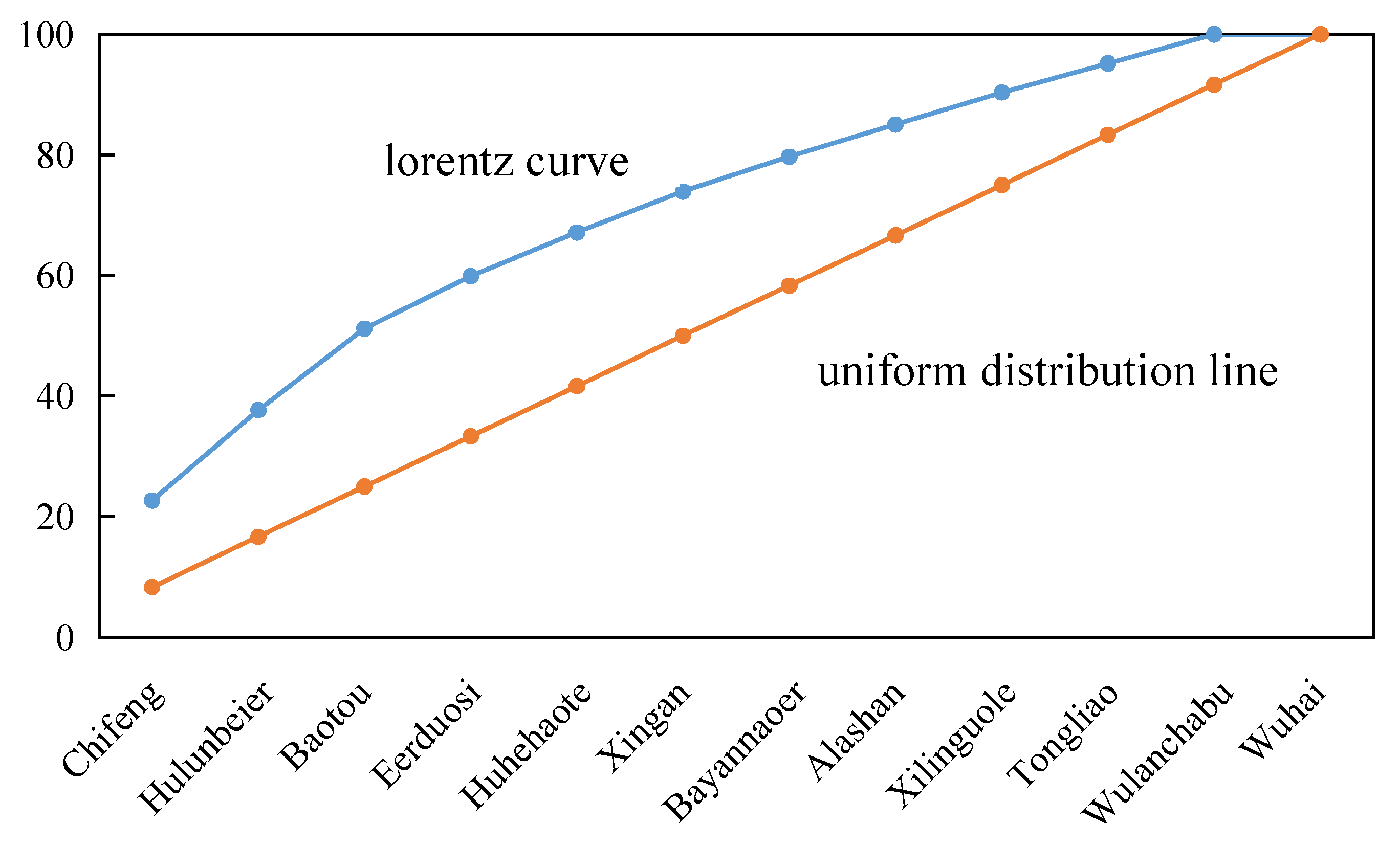
- The imbalance index of traditional villages in Inner Mongolia is S = 0.387. The Lorentz curve is far from the average distribution line, and the bending is obvious. The geographical concentration index = 35.1 > 17.25, which shows that from the perspective of the city, the distribution of traditional villages in Inner Mongolia is uneven, mainly concentrated in Chifeng, Hulunbeier, Baotou, and Eerduosi.
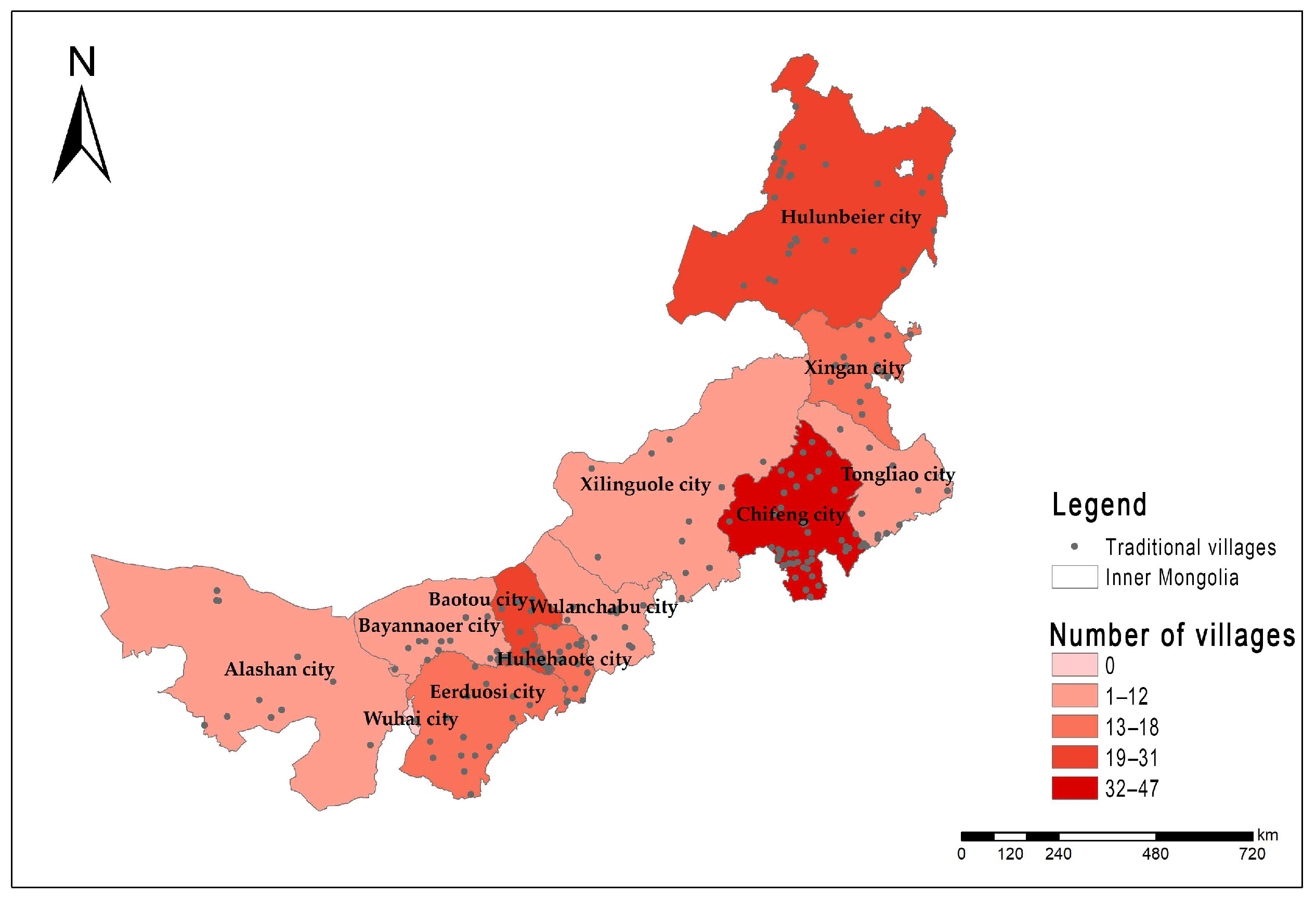
- The Gini coefficient shows that the distribution of traditional villages in Inner Mongolia is denser in the center than in the north and denser in the east than in the west, with the densest characteristics in the central region.
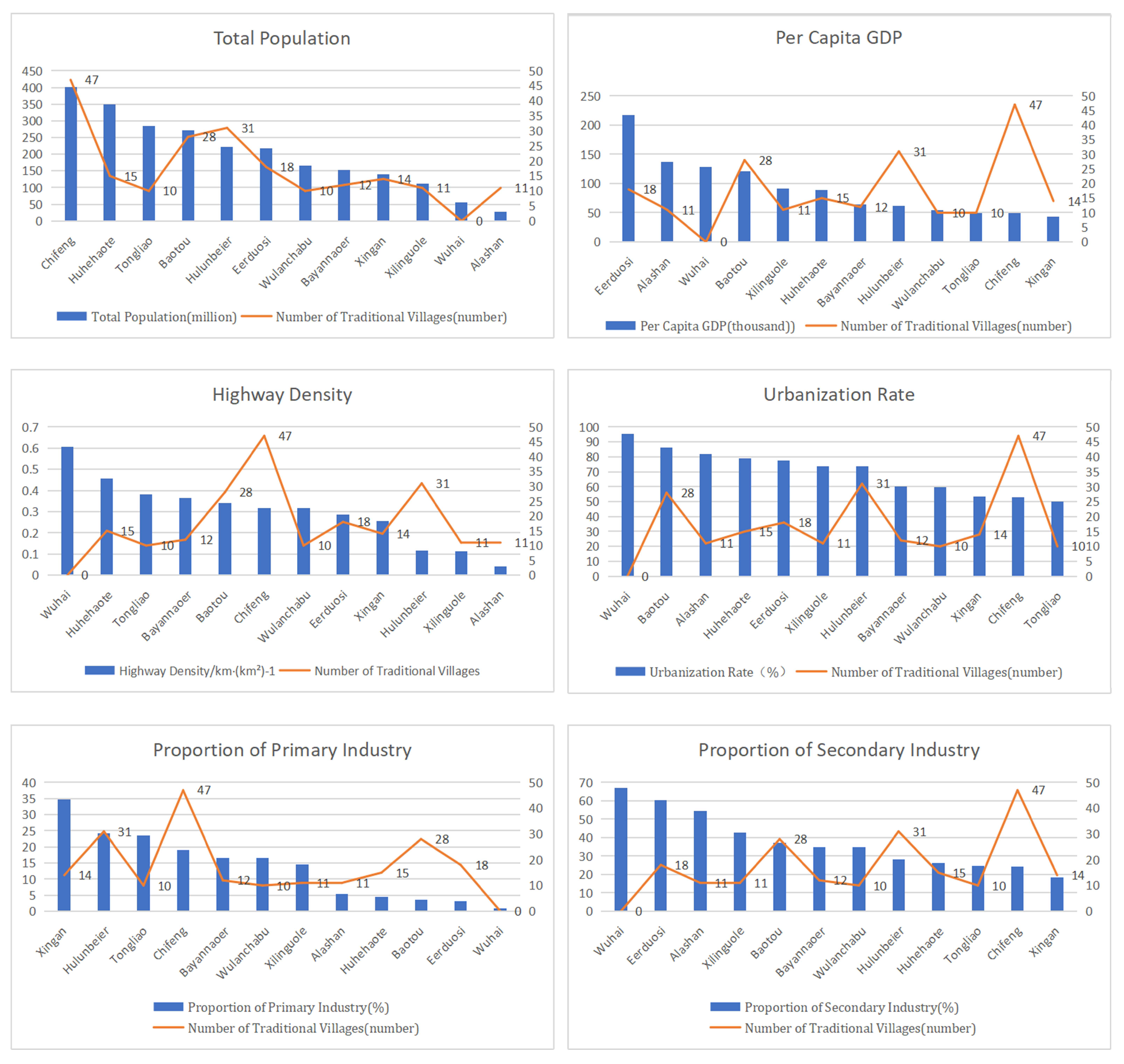
- Socio-economic factors and natural geographical factors are important factors affecting the spatial distribution of traditional villages in Inner Mongolia, especially socio-economic factors. Among them, the economic level, traffic conditions, population, elevation, and temperature conditions are the main factors affecting the spatial distribution of traditional villages in Inner Mongolia.
- Socio-economic factors and natural geographical factors are important factors affecting the spatial distribution of traditional villages in Inner Mongolia, especially the socio-economic factors. Among them, the highway density, the proportion of the primary industry, the number of intangible cultural heritages, and the total population are the main factors affecting the spatial distribution of traditional villages in Inner Mongolia.
Author Contributions
Funding
Data Availability Statement
Conflicts of Interest
References
- Liu, D.; Hu, J.; Chen, J.; Xu, X. Study on the spatial distribution pattern of traditional villages in China. China Popul. Resour. Environ. 2014, 24, 157–162. [Google Scholar]
- Li, B.; Liu, P.; Dou, Y.; Zeng, C.; Chen, C. The transformation and development of human settlements in traditional villages in China and its research progress. Geogr. Res. 2017, 36, 1886–1900. [Google Scholar]
- Feng, J. Dilemma and Outlet of Traditional Villages—Traditional villages are another type of cultural heritage. Folk. Cult. Forum 2013, 1, 7–12. [Google Scholar]
- Hu, Y.; Chen, S.; Cao, W.; Cao, C. The concept and cultural connotation of traditional villages. Urban Dev. Res. 2014, 21, 10–13. [Google Scholar]
- Gauthiez, B. The History of urban morphology. Urban Morphol. 2004, 8, 71–89. [Google Scholar] [CrossRef]
- Williams, M. The Apple of my eye: Carl Sauer and Historical Geography. J. Hist. Geogr. 1993, 9, 1–28. [Google Scholar] [CrossRef]
- Sauer, C.O. The Fourth Dimension of Geography. Ann. Assoc. Am. Geogr. 1974, 64, 189–192. [Google Scholar] [CrossRef]
- Liao, J. The protection and development of traditional villages from the perspective of rural revitalization. Reform 2018, 4, 130–139. [Google Scholar]
- Feng, W.; Huang, Z.; Zhang, Y.; Liu, Y.; Pang, M. Landscape beauty of Dong traditional villages in southeastern Guizhou. Ecol. J. 2019, 38, 3820–3830. [Google Scholar]
- Čurović, Ž.; Čurović, M.; Spalević, V.; Janic, M.; Sestras, P.; Popović, S.G. Identification and Evaluation of Landscape as a Precondition for Planning Revitalization and Development of Mediterranean Rural Settlements—Case Study: Mrkovi Village, Bay of Kotor, Montenegro. Sustainability 2019, 11, 2039. [Google Scholar] [CrossRef]
- Liu, P.; Yu, H. Evaluation of Rural Heritage of Ancient Villages in Tourism Development—A Case Study of Cuandixia Village, Mentougou District, Beijing. Geogr. Sci. 2012, 32, 1304–1310. [Google Scholar]
- Shan, Y.; Zhao, T.; Ma, H. Discussion on the value evaluation index system of traditional villages—Taking Yiwu traditional villages as an example. Anc. Landsc. Technol. 2020, 2, 84–88. [Google Scholar]
- Chen, B.; Nakama, Y. A study on village forest landscape in small island topography in Okinawa, Japan. Urban For. Urban Green. 2010, 9, 139–148. [Google Scholar] [CrossRef]
- Xiang, Y.; Cao, M.; Yan, F.; Sun, F. The spatial and temporal characteristics of traditional villages in Shaanxi and their protection strategies. Urban Dev. Res. 2019, 26, 27–32. [Google Scholar]
- Li, T.; Zhai, H.; Hu, K. Research on the protection of traditional villages in Shangri-La from the perspective of scene, character, and spiritual-cultural landscape. Chin. Gard. 2020, 36, 37–42. [Google Scholar]
- Tas, M. A Participatory Governance Model for the Sustainable Development of Cumalikizik, A Heritage Site in Turkey. Environ. Urban. 2009, 21, 161–184. [Google Scholar] [CrossRef]
- Marschalek, I. The Concept of Participatory Local Sustainability Projects in Seven Chinese Villages. J. Environ. Manag. 2015, 87, 226–235. [Google Scholar] [CrossRef]
- Chen, G. Research on Rural Revitalization and Traditional Village Tourism Development in Ethnic Areas from the Perspective of Development Anthropology. Guizhou Ethn. Stud. 2021, 42, 160–164. [Google Scholar]
- Li, P.; Wang, Q.; Ryan, C. Research on the impact of tourism on traditional villages-Taking Qiyun Mountain in Anhui Province as an example. Tour. J. 2012, 27, 57–63. [Google Scholar]
- Ren, K.; Yang, J. Rural landscape construction based on spatial production-ecological dialectical relationship-observation of traditional villages and towns in northwestern Shanxi. Mod. Urban Res. 2019, 9, 26–33. [Google Scholar]
- Wang, W.; Liu, Y.; Chen, G. Research on the spatial distribution characteristics and influencing factors of traditional villages in the Yangtze River Delta region. Ind. Build. 2023, 24, 1–15. [Google Scholar]
- Sprague, D.S. Land-use configuration under traditional agriculture in the Kanto Plain, Japan: A historical GIS analysis. Int. J. Geogr. Inf. Sci. 2013, 27, 68–91. [Google Scholar] [CrossRef]
- Liu, S.; Fan, H.; Wang, Y.; Gao, X. The spatial characteristics and correlation analysis of traditional villages in the Minjiang River Basin. Mod. City Res. 2019, 9, 17–25. [Google Scholar]
- Li, M.; Rui, Y.; Wang, C.; Ji, Y.; Li, Y. Study on the spatial distribution and influencing factors of traditional villages-Taking Wuyue cultural area as an example. Resour. Environ. Yangtze River Basin 2018, 27, 1693–1702. [Google Scholar]
- Jia, A.; Liang, X.; Wen, X.; Yun, X.; Ren, L.; Yun, Y. GIS-Based Analysis of the Spatial Distribution and Influencing Factors of Traditional Villages in Hebei Province, China. Sustainability 2023, 15, 9089. [Google Scholar] [CrossRef]
- Wang, P.; Zhang, J.; Sun, F.; Cao, S.; Kan, Y.; Wang, C.; Xu, D. The spatial distribution characteristics and influencing mechanism of traditional villages in Southwest China. Econ. Geogr. 2021, 41, 204–213. [Google Scholar]
- Qiu, Z.; Hu, X.; Qian, H.; Liao, K.; Huang, X.; Liu, Y.; Wei, B. The spatial and temporal distribution characteristics and influencing factors of traditional villages in Fujian Province. Econ. Geogr. 2023, 43, 211–219. [Google Scholar]
- Wang, S.; Sun, J. Construction and demonstration of sustainable development evaluation system of traditional villages in China. Geography 2021, 76, 921–938. [Google Scholar]
- Ma, H.D.; Tong, Y.Q. Spatial differentiation of traditional villages using ArcGIS and GeoDa: A case study of Southwest China. Ecol. Inform. 2022, 68, 101416. [Google Scholar] [CrossRef]
- Cheng, H.; Li, N.; Mao, Z. A preliminary study on the dynamic mechanism of traditional village renewal-based on the current tourism development background. Archit. J. 2011, 9, 100–103. [Google Scholar]
- Bao, Y.; Sun, Z.; Song, M.; Li, Z.; Ye, X.; Zang, D. Research on the influencing factors of cultural vitality of public space in traditional villages in Lanxi, Zhejiang Province from the perspective of residents’ perception. Reg. Res. Dev. 2019, 38, 175–180. [Google Scholar]
- Jin, L.; Jiao, S. Research on the public space structure and formation mechanism of traditional villages based on graph theory. Planner 2019, 35, 52–57. [Google Scholar]
- Dai, Y.; Chen, W.; Gao, H.; Ma, Y. The spatial distribution characteristics and influencing factors of traditional villages in Henan Province. Reg. Res. Dev. 2020, 39, 122–126. [Google Scholar]
- Wu, P. Authenticity protection and construction of traditional villages in southeastern Guizhou—Reflections on the goal of beautiful rural construction. Guizhou Soc. Sci. 2018, 11, 92–97. [Google Scholar]
- Zhang, M.; Zhu, Y.; Yu, T. Study on the spatial distribution characteristics and influencing factors of traditional villages in Qingdao. Mod. Urban Res. 2020, 12, 18–28. [Google Scholar]
- Yu, Y.; Song, Y.; Hu, D.; Yu, X. Analysis of the spatial distribution and influencing factors of traditional villages in the Yangtze River Economic Belt. Reg. Res. Dev. 2020, 39, 7–12. [Google Scholar]
- Wen, J.; Wu, Y. Villages with the loss of ‘villagers’: The transformation of traditional villages and its rural reflection—Empirical research based on 15 typical villages. Sociol. Res. 2017, 32, 22–45+242–243. [Google Scholar]
- Du, L. Research on the Activation Development of Traditional Bamboo and Wood Ethnic Crafts Culture Industry in Poor Mountainous Areas—A Case Study of Ethnic Villages in Mountainous Areas of Rongjiang River Basin in Guangxi. Guangxi Ethn. Stud. 2020, 2, 122–128. [Google Scholar]
- Li, J.; Wang, X.; Li, X. Analysis of spatial distribution characteristics and influencing factors of traditional villages in China. Econ. Geogr. 2020, 40, 143–153. [Google Scholar]
- Fan, T.; Yang, Q.; He, J.; Pan, F.; Deng, Y. Spatial Layout Optimization of Rural Settlements in Hilly Areas of Chongqing—A Case Study of Haitang Town, Changshou District. Geogr. Res. 2015, 34, 883–894. [Google Scholar]
- Gao, J.; Wu, B.H. Revitalizing Traditional Villages through Rural Tourism: A Case Study of Yuanjia Village, Shaanxi Province, China. Tour. Manag. 2017, 63, 223–233. [Google Scholar] [CrossRef]
- Wang, Y.; Li, S.; Jiu, J.; Ren, M.; Fan, Y.; Su, J. Study on the spatial distribution characteristics and influencing factors of traditional villages in Henan Province. China Agric. Resour. Reg. 2019, 40, 129–136 + 204. [Google Scholar]
- Min, Z.; Huang, P.; Duan, Y. Analysis of water management wisdom in traditional villages-Taking Liukeng Village in Jiangxi Province as an example. Urban Dev. Res. 2018, 25, 7–11. [Google Scholar]
- Feng, Y.; Yu, W.; Lei, R. Study on the spatial distribution characteristics and influencing factors of traditional villages in Guangdong Province. Geogr. Sci. 2017, 37, 236–243. [Google Scholar]
- Liang, B.; Xiao, D.; Tao, J.; Ji, J.; Zhuo, X.; Huang, Y. The Spatial and Temporal Pattern and Evolution of the Distribution of Hakka Traditional Villages in Ganzhou. Econ. Geogr. 2018, 38, 196–203. [Google Scholar]
- Wang, J.; Xu, C. Geodetectors: Principles and Prospects. Geogr. J. 2017, 72, 116–134. [Google Scholar]
- Shen, H.; Zheng, J.; Tang, F.; Wu, G. Analysis of spatial distribution characteristics of A-level tourist attractions in Henan Province. Econ. Geogr. 2013, 33, 179–183. [Google Scholar]
- Song, S.; Ju, Y.; Wang, H. Possible effects of land use change caused by orderly human activities on regional precipitation. Clim. Environ. Stud. 2008, 13, 759–774. [Google Scholar]
- Li, S.; Song, Y.; Xu, H.; Li, Y. Research on the spatial distribution characteristics and driving factors of Chinese traditional villages based on GWR modeling and geodetectors-Taking the Abo Mountain area as an example. Sustain. Dev. 2023, 15, 3443. [Google Scholar]
- Rahman, A.A.; Hasshim, S.A.; Rozali, R. Residents’ preference on conservation of the Malay traditional village in Kampong Morten, Malacca. Procedia-Soc. Behav. Sci. 2015, 202, 417–423. [Google Scholar] [CrossRef]
- Kim, G.W.; Kang, W.; Park, C.R.; Lee, D. Factors of spatial distribution of Korean village groves and relevance to landscape conservation. Landsc. Urban Plan. 2018, 176, 30–37. [Google Scholar] [CrossRef]
- Bian, J.; Chen, W. The spatial distribution characteristics and influencing factors of Chinese traditional villages. Int. Environ. Res. Public Health 2022, 19, 4627. [Google Scholar] [CrossRef]
- Fu, X.L. Cognitive research on spatial morphology of traditional villages based on ecological perspective. Fresenius Environ. Bull. 2021, 30, 2285–2289. [Google Scholar]
- Xue, M.; Wang, C.; Dou, W.; Wang, Z. Study on the spatial distribution characteristics and influencing factors of traditional villages in the Yellow River Basin. Resour. Environ. Arid. Areas 2020, 34, 94–99. [Google Scholar]
- He, X.Q.; Gong, S.S.; Hu, J.; Xu, J.J. Spatial Differentiation and It’s Influence Factors of Traditional Villages in Hunan, Hubei and Jiangxi Provinces at Different Scales. Resour. Environ. Yangtze Basin 2019, 28, 2857–2866. [Google Scholar]
- Li, S.; Song, Y.; Xu, H.; Li, Y.; Zhou, S. Spatial Distribution Characteristics and Driving Factors for Traditional Villages in Areas of China Based on GWR Modeling and Geodetector: A Case Study of the Awa Mountain Area. Sustainability 2023, 15, 3443. [Google Scholar] [CrossRef]
- Yang, Q. On the policy of the Qing Dynasty to the Han immigrants in Mongolia. Liaoning Norm. Univ. 2005, 2, 113–115. [Google Scholar]
- Kong, J. Research on the characteristics and protection strategies of the filing investigation mechanism of traditional villages in Shaanxi Province. Cult. J. 2021, 4, 16–18. [Google Scholar]


| City Name | Number of Traditional Villages | Billing | Proportion/% | Cumulative Proportion/% |
|---|---|---|---|---|
| Chifeng | 47 | 1 | 22.71 | 22.71 |
| Hulunbeier | 31 | 2 | 14.98 | 37.68 |
| Baotou | 28 | 3 | 13.53 | 51.21 |
| Eerduosi | 18 | 4 | 8.70 | 59.90 |
| Huhehaote | 15 | 5 | 7.25 | 67.15 |
| Xingan | 14 | 6 | 6.76 | 73.91 |
| Bayannaoer | 12 | 7 | 5.80 | 79.71 |
| Alashan | 11 | 8 | 5.31 | 85.02 |
| Xilinguole | 11 | 9 | 5.31 | 90.34 |
| Tongliao | 10 | 10 | 4.83 | 95.17 |
| Wulanchabu | 10 | 11 | 4.83 | 100.00 |
| Wuhai | 0 | 12 | 0 | 100.00 |
| Total | 207 |
| Region | Number of Traditional Villages | Proportion | Area/km2 | Density/units/10,000 km2 | Including the City |
|---|---|---|---|---|---|
| Northern Region | 45 | 40.10% | 308,100 | 1.46 | Hulunbeier, Xingan |
| Eastern Region | 68 | 32.85% | 352,135 | 1.93 | Tongliao, Chifeng, Xilinguole |
| Central Region | 83 | 21.74% | 251,568 | 3.30 | Wulanchabu, Baotou, Huhehaote, Eerduosi, Bayannaoer |
| Western Region | 11 | 5.31% | 271,754 | 0.40 | Alashan, Wuhai |
| Total | 207 |
| Elevation | Under 200 m | 200–500 m | 500–1000 m | 1000–1500 m | 1500–3526 m | Grand Total |
|---|---|---|---|---|---|---|
| Number of Traditional Villages | 4 | 36 | 64 | 92 | 11 | 207 |
| Proportion | 1.93% | 17.39% | 30.92% | 44.44% | 5.31% | 1 |
| Slope Value | 0–5° | 5–10° | 10–15° | 15–20° | >20° | Grand Total |
|---|---|---|---|---|---|---|
| Number of Traditional Villages | 184 | 16 | 4 | 1 | 0 | 207 |
| Proportion | 88.89% | 7.73% | 1.93% | 0.48% | 0% | 1 |
| Slope Aspect | Flat Ground | North | Northeast | East | Southeast | South | Southwest | West | Northwest | Grand Total |
|---|---|---|---|---|---|---|---|---|---|---|
| Number of Traditional Villages | 2 | 17 | 12 | 19 | 47 | 53 | 17 | 22 | 18 | 207 |
| Proportion | 0.97% | 8.21% | 5.80% | 9.18% | 22.71% | 25.60% | 8.21% | 10.63% | 8.70% | 1 |
| Buffer Distance | 2.5 km below | 2.5–5 km | 5–10 km | 10–15 km | 15–20 km | More than 20 km | Grand Total |
|---|---|---|---|---|---|---|---|
| Number of Traditional Villages | 63 | 25 | 24 | 22 | 11 | 62 | 207 |
| Proportion | 30.43% | 12.08% | 11.59% | 10.63% | 5.31% | 29.95% | 1 |
| Annual Average Precipitation Range | 27.972–108.913 mm | 108.913–193.619 mm | 193.619–270.796 mm | 270.796–342.325 mm | 342.325–507.972 mm | Grand Total |
|---|---|---|---|---|---|---|
| Number of Traditional Villages | 8 | 18 | 53 | 86 | 42 | 207 |
| Proportion | 3.86% | 8.70% | 25.60% | 41.55% | 20.29% | 1 |
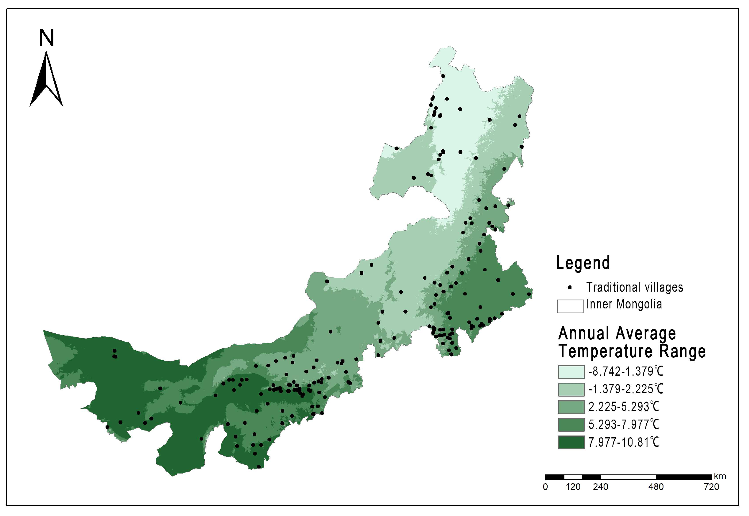
| Annual Average Temperature Range | −8.742–1.379 °C | −1.379–2.225 °C | 2.225–5.293 °C | 5.293–7.977 °C | 7.977–10.81 °C | Grand Total |
|---|---|---|---|---|---|---|
| Number of Traditional Villages | 14 | 19 | 52 | 72 | 48 | 207 |
| Proportion | 6.76% | 9.18% | 25.12% | 34.78% | 23.19% | 1 |
| Level of Influencing Factors | Serial Number | Index Factors | q Statistic |
|---|---|---|---|
| Natural Geographical Factor | X1 | elevation (m) | 0.086 |
| X2 | river distance (km) | 0.003 | |
| X3 | annual average precipitation (mm) | 0.035 | |
| X4 | annual average temperature (°C) | 0.283 | |
| X5 | plop value (°) | 0.003 | |
| X6 | aspect (°) | 0.001 | |
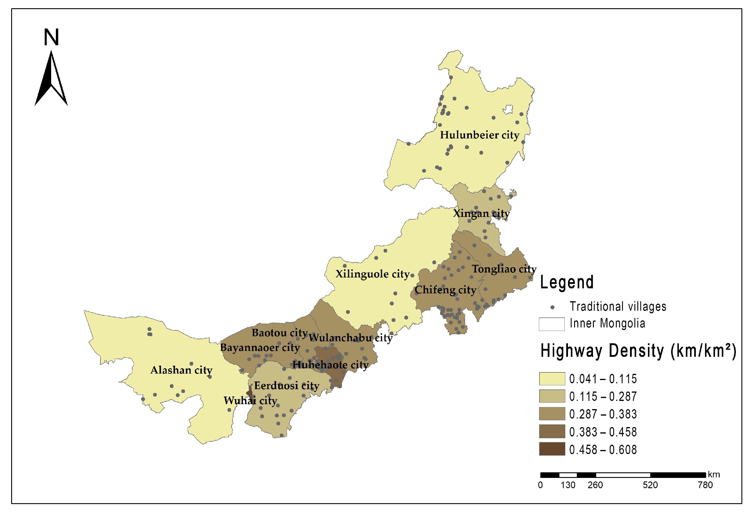
| Socioeconomic Factor | X7 | highway density (km/(km2)) | 0.566 |
| X8 | total population (million) | 0.481 | |
| X9 | per capital GDP (thousand) | 0.477 | |
| X10 | urbanization rate (%) | 0.483 | |
| X11 | number of intangible cultural heritage | 0.467 | |
| X12 | proportion of primary industry (%) | 0.542 | |
| X13 | proportion of secondary industry (%) | 0.383 |
Disclaimer/Publisher’s Note: The statements, opinions and data contained in all publications are solely those of the individual author(s) and contributor(s) and not of MDPI and/or the editor(s). MDPI and/or the editor(s) disclaim responsibility for any injury to people or property resulting from any ideas, methods, instructions or products referred to in the content. |
© 2023 by the authors. Licensee MDPI, Basel, Switzerland. This article is an open access article distributed under the terms and conditions of the Creative Commons Attribution (CC BY) license (https://creativecommons.org/licenses/by/4.0/).
Share and Cite
Li, D.; Gao, X.; Lv, S.; Zhao, W.; Yuan, M.; Li, P. Spatial Distribution and Influencing Factors of Traditional Villages in Inner Mongolia Autonomous Region. Buildings 2023, 13, 2807. https://doi.org/10.3390/buildings13112807
Li D, Gao X, Lv S, Zhao W, Yuan M, Li P. Spatial Distribution and Influencing Factors of Traditional Villages in Inner Mongolia Autonomous Region. Buildings. 2023; 13(11):2807. https://doi.org/10.3390/buildings13112807
Chicago/Turabian StyleLi, Donghao, Xinchun Gao, Siyang Lv, Wanwan Zhao, Meng Yuan, and Pengtao Li. 2023. "Spatial Distribution and Influencing Factors of Traditional Villages in Inner Mongolia Autonomous Region" Buildings 13, no. 11: 2807. https://doi.org/10.3390/buildings13112807
APA StyleLi, D., Gao, X., Lv, S., Zhao, W., Yuan, M., & Li, P. (2023). Spatial Distribution and Influencing Factors of Traditional Villages in Inner Mongolia Autonomous Region. Buildings, 13(11), 2807. https://doi.org/10.3390/buildings13112807