1. Introduction
A tall building cluster is formed when several tall buildings are co-located in a confined area such as a town center or central business district (CBD). Historically, the emergence of tall buildings has been fueled by the needs of an enormous population concentrated in a limited space within the city. In major cities, land is always a scarce resource for urban development, which impacts land prices. For this reason, by providing tall buildings with large functional spaces and limited footprints, the utilization of scarce urban land can be maximized. Moreover, related to urban densities, tall buildings contribute to the quality of urban spaces [
1]. When tall buildings and dense populations are concentrated closely, more opportunities are available for walking and cycling; therefore, travel distances and carbon emissions can be reduced. Although tall buildings have the advantages of solving the problems originating in the city (e.g., urban population, land prices and consumption, economic, energy and climate change, infrastructure, etc.), the lack of a specific strategic approach for the arrangement of tall buildings is likely to incur negative impacts on the site and lower the quality of the city. If a high population density and tall buildings are not supported by appropriate infrastructure, it can lead to traffic congestion, overcrowding, and open spaces rendered unusable by air pollution, noise, and lack of continuity [
2,
3]. However, the negative impacts can be minimized and benefits can be realized if tall buildings are planned well.
Design guidance is required to advise developers and architects in designing proposed buildings and spaces, for example, guidelines to control the building height, skyline, and streetscape; to minimize the impact of development; to divert pressure for development away from areas of historical value; and to manage economic growth effectively. Most arguments that new skyscrapers are necessary to improve urban densities, reduce sprawl, increase sustainability, and so on are almost entirely plausible. Despite this, French urbanist Jean-Marie Huriot argues that overall urban densities are often higher in densely built streets than in cities dotted with clusters of huge towers [
4]. Clustering tall buildings in one area certainly has specific purposes, especially in urban design. Designing specific areas for tall building clusters can support urban agglomeration that hinges on the proximity of activities. The legibility of the built area can be enhanced by the distinctness of the skyline from surrounding areas.
Generally, the concept of clustering tall buildings is widely accepted as the most positive means of introducing tall forms into the skyline of a city within the context of comprehensive redevelopment or regeneration projects. It has been argued that regeneration areas should be marked by tall buildings to signal change, raise the profile, and generate confidence of investors in the area and its opportunities [
5,
6]. For instance, a cluster of tall buildings in Canary Wharf forms an essential part of the city’s image as an internationally recognizable feature on the skyline that represents one of London’s financial centers and is a symbol of the successful regeneration of the former docklands. Moreover, locating tall buildings in economic clusters that are served by public transport is regarded as a sustainable approach to urban planning. Although clustering tall buildings around major transport nodes increases efficiency in travel time and distance, the capacity from each use and movement of private vehicular, buses, trams, underground metro system, and rail networks around a tall building cluster requires an assessment to ascertain how that capacity will be affected and potentially increase traffic congestion [
7]. As well as enabling more efficient public transport systems, clustering attempts to discourage tall buildings from being developed at random locations across the city that would create a dispersed skyline of little or no quality, which also negatively impacts the existing heritage and value of the skyline. Clustering involves several elements including the plotting of sightlines and views of protected monuments, buildings, or other areas as well as a townscape analysis including an understanding of the townscape’s character and value. The management of key views is also a part of tall building design to protect important buildings, sites, areas, and landmarks [
8]. In the present day, control over the development and character of overall skylines has increased. Sir Hugh Casson suggests that, to govern and change the skylines of English cities, a group of high buildings is to be preferred, in principle, over a few dispersed and isolated structures. London’s government issued a policy that focuses on the size, scale, and consequent impact of tall buildings on London’s built heritage and skyline. The notion of clusters of towers, combined with the protection of important views of St. Paul’s Cathedral from the intrusion of tall buildings, has been proven to be influential in London. The Shard, a mixed residential and commercial tower designed by Renzo Piano, while having a definite visual impact on the Tower of London World Heritage Site and St. Paul’s Cathedral from a strategic view, was appropriately located and of the highest design quality, and therefore does not harm these buildings or nearby listed buildings and conservation areas [
9].
However, tall building clusters may impede the potential of building-integrated renewable energy systems. Furthermore, the density of tall buildings may reduce space for trees and shrubs that purify the air and cool the inner urban areas. The high proportion of built-up mass and the loss of greenery are causes of the urban heat island effect [
3]. The use of clustering requires a mature approach to manage the urban change so that tall buildings can contribute to the cityscape without necessarily resulting in the destruction of the character of the city. Furthermore, as part of city development strategy execution plans, an interest in development density or height should be defined as a method to accomplish a high-rise–high-density concentration, shifting from high-rise–high-density or low-rise–low-density dichotomy.
Apart from the positive and negative impacts of new tall buildings upon the skyline, they can also enhance a cluster of tall buildings on the skyline or detract from that cluster if inappropriately situated. In situations where a skyline lacks cohesiveness or recognizability, a single structure can become an accent, a punctuation point, or the tallest building that draws and focuses attention. This element can draw all the scattered buildings together as a whole [
10] and break the monotony of buildings that are similar in height [
11]. The tallest buildings clustered at the centers of the most important corporate and financial areas such as Kingdom Tower in Jeddah and the Burj Khalifa skyscraper in Dubai also feed off extreme competition for building sites and super-high land values [
4]. These clusters can provide high densities and distinguish the urban centers. Tall buildings can be grouped in a cluster to create a more defined impact on the overall skyline, which could be lost if the same buildings are dotted randomly throughout the area. As such, their setting requires particularly careful attention and consideration of the role that they play in the town. The success of a city in creating a unique skyline can be assessed by the way tall buildings are arranged as a response to the urban spatial arrangement. The planners of tall building clusters should conduct in-depth analyses concerning the urban context to ensure that the modified skyline provides an attractive view.
The objective of this research is to compare tall buildings clustered in circular, rectangular, and linear geographical areas and examine the impact of the different spatial layouts of clusters on the skyline. This means dealing with the spatial layout in an urban context and for the visual quality of the skyline. The comparison refers to two factors, namely, visibility and height transition. Visibility addresses how much of the tall buildings’ surfaces are visible. Height transition deals with the transition between taller and shorter buildings in response to the urban context. This research is expected to determine the design factors that need attention for designing tall building clusters, particularly under preferences for visibility and height transition.
2. Impact of Tall Buildings on the Skyline
The impact of a tall building on a modern city’s skyline is significantly greater than that of an ordinarily sized building. As the most prominent part of an urban landscape, tall buildings can significantly alter the panoramic view of the skyline, and their symbolic value can be excessively powerful. Tall buildings can either epitomize people’s pride in their city or represent their disdain for a visual eyesore. Today, major cities are concerned with improving their image as an attractive tourist destination based on economic condition and urban prestige. The form of the city skyline is an important component of this image, which is predominantly composed of tall buildings. Generally, the impact of tall buildings in architecture, urban planning, and urban design can be considered with respect to three main features [
12]:
Related to the visual dimension, the role of the physical factors of tall buildings in forming the skyline, and their visibility in urban views.
In comparison to other buildings, the capability of tall buildings to accommodate more humans and cars.
On the environmental effects such as the local microclimate, wind circulation, and shade.
There have been several studies that have considered the impact of tall buildings on the skyline. Concerning the physical factors of tall buildings, height is the biggest factor in the visual impact of tall buildings, in addition to the complexity of the buildings’ tops and colors [
13]. Heath, et al. [
14] pointed out the relationship between the complexity of the silhouette of the buildings making up an urban skyline and popular preference. Additionally, Smith, et al. [
15] investigated the interaction of the height proportion and spacing of tall buildings with the preferences of the skyline using the mathematical model developed by Lim and Heath [
16]. It was shown in the study by Lim and Heath [
16] that slenderness and spacing between tall buildings tended to enhance the skyline by linking their tops to approximate a smooth, convex form that is perceived as a single complex. In another study, Stamps III [
17] confirmed that the relative complexity is a predictor of preference for individual high-rise buildings. Further study by Stamps III, et al. [
18] investigated the juxtaposition of tall buildings from a public point of view with an emphasis on the skyline, height changes, and rotation in the general shape of the roofs of tall buildings.
Regarding their impact on urban views, the visual aspect of tall buildings can also be approached in terms of their visibility. Rød and van der Meer [
19] demonstrated that geographic information system (GIS)-aided visibility and dominance could be analyzed to assess the visual impact of a planned high-rise building. Van der Hoeven and Nijhuis [
20] offered a new approach to the visibility analysis of high-rise building development using a GIS-based map that showed visual coverage and cumulative visibility, wherein the role of tall buildings in the cluster can be perceived visually, instead of being considered individually. Czyńska and Rubinowicz [
21] proposed the visual impact size (VIS) method to determine the change in the visibility area impacted by the location and height of tall buildings. Karimimoshaver and Winkemann [
12] also introduced ArcGIS to calculate the visibility of a single tall building by measuring the ratio of the visible area of the building to the visual field.
As a summary of the above studies, visibility and height should be treated as the key factors of designing tall buildings while respecting the impact on the skyline, particularly in designing tall building clusters that can maintain the skyline. Research will mainly focus on the spatial layout of a different cluster that might yield a different impact in terms of visibility and height transition.
3. Materials and Methods
First, the 3D building model was created in Rhino 3D, and Elk tools were used to generate the field map and topographical surface from Open Street Map (OSM) and digital elevation model (DEM). On this map, the buildings were extruded based on their building elevation data. The building elevation and precise location data on the site were derived from the Council on Tall Buildings and Urban Habitat and the Emporis building database. Objectively, in this research, buildings taller than 100 m were considered tall buildings that are distinct from their context and confined in an area such as a Central Business District or built area.
The method used for visibility analysis is able to utilize the advantages of Grasshopper and Rhino 3D because of the integration of modeling, simulation, and visualization within one interface. The visibility analysis was developed in an algorithm using Grasshopper and was integrated with the input of the building models in Rhino 3D. Ladybug’s “view analysis” component was used as the main component in the algorithm to calculate the visibility of tall buildings (
Figure 1). The simulation runs within algorithm scripting, which consists of the following required inputs:
Geometry—3D model of the tall buildings that will be tested for targeted visibility analysis.
Context—3D models of the tall buildings within the cluster that may block visibility.
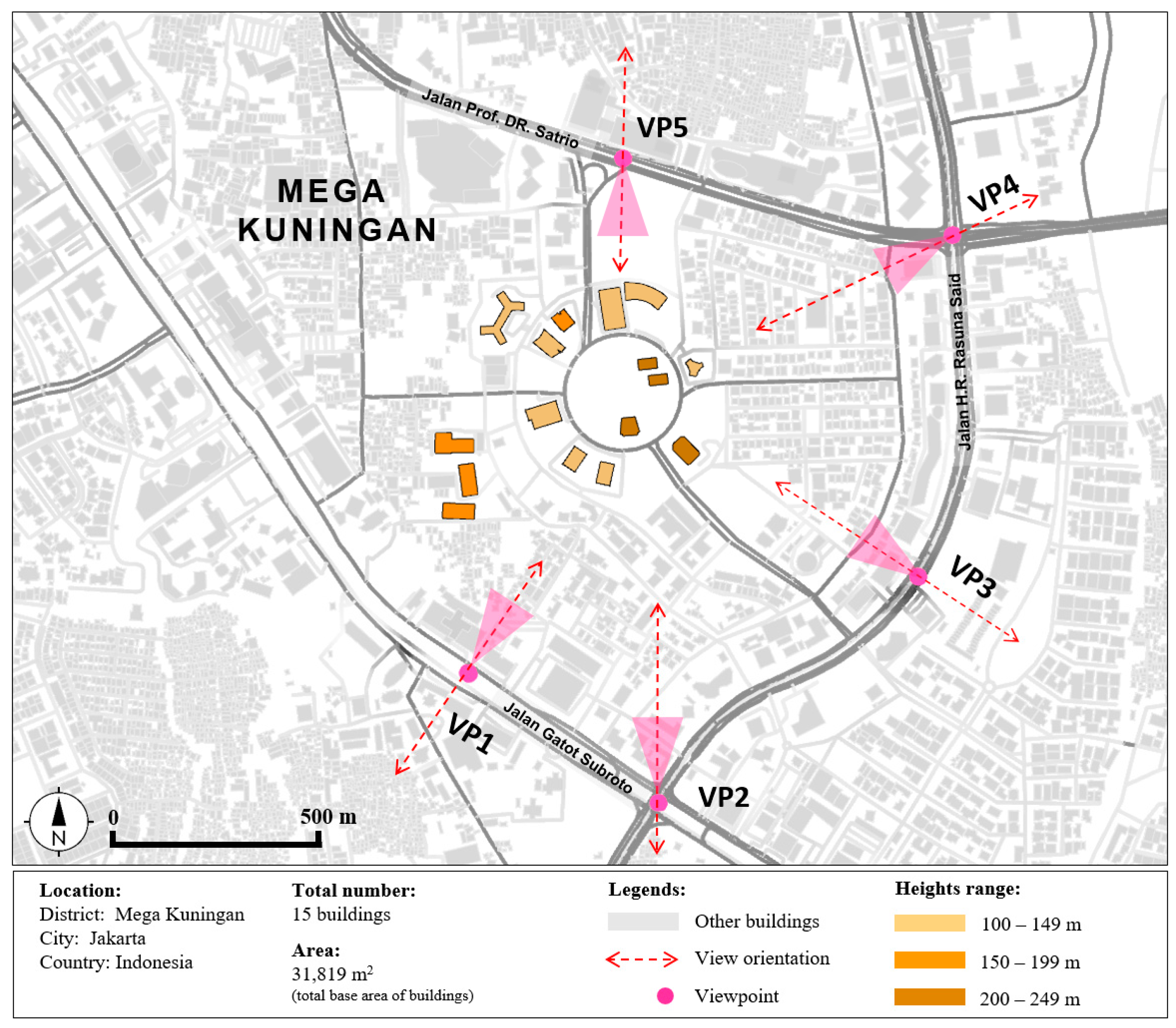
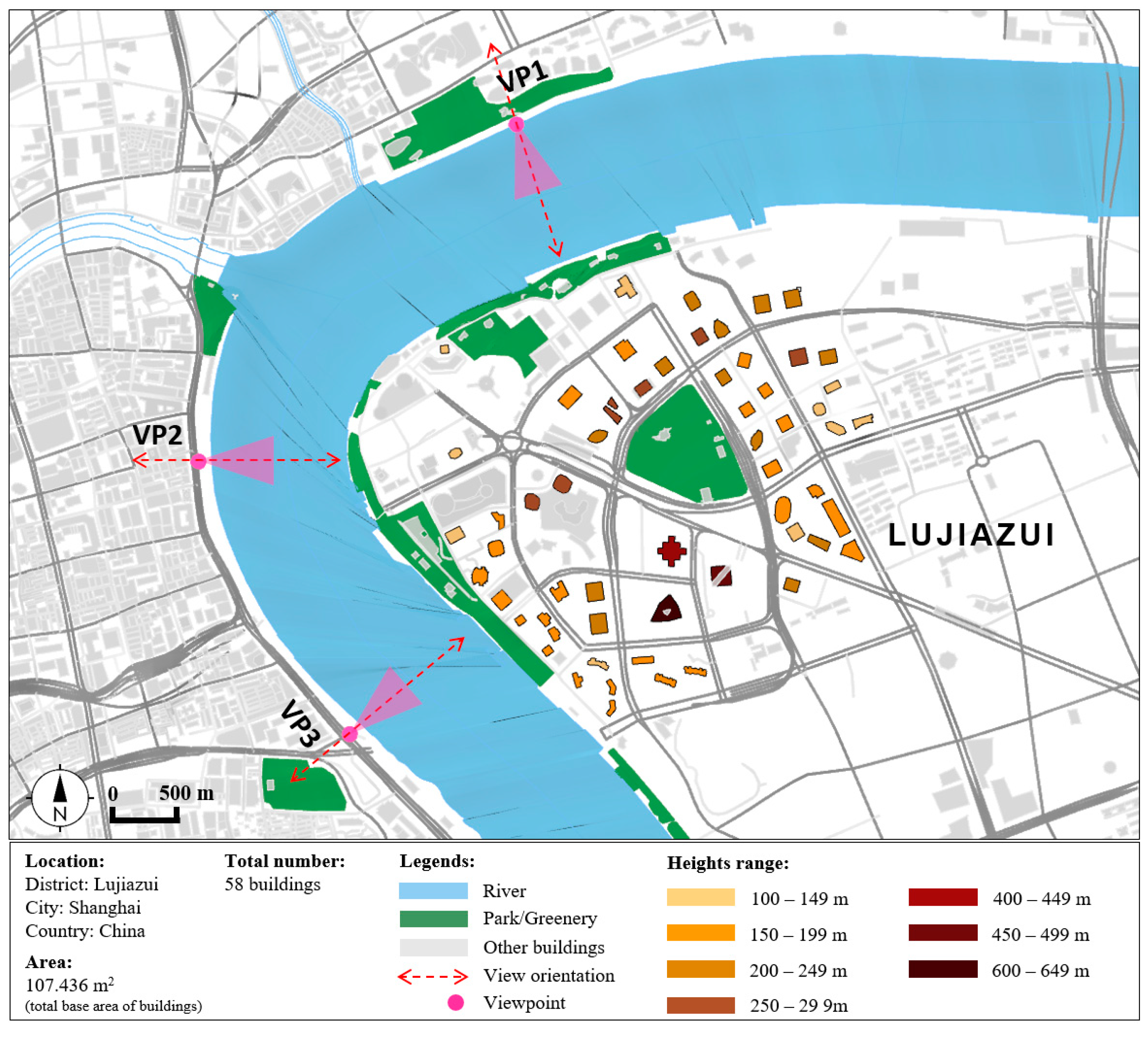
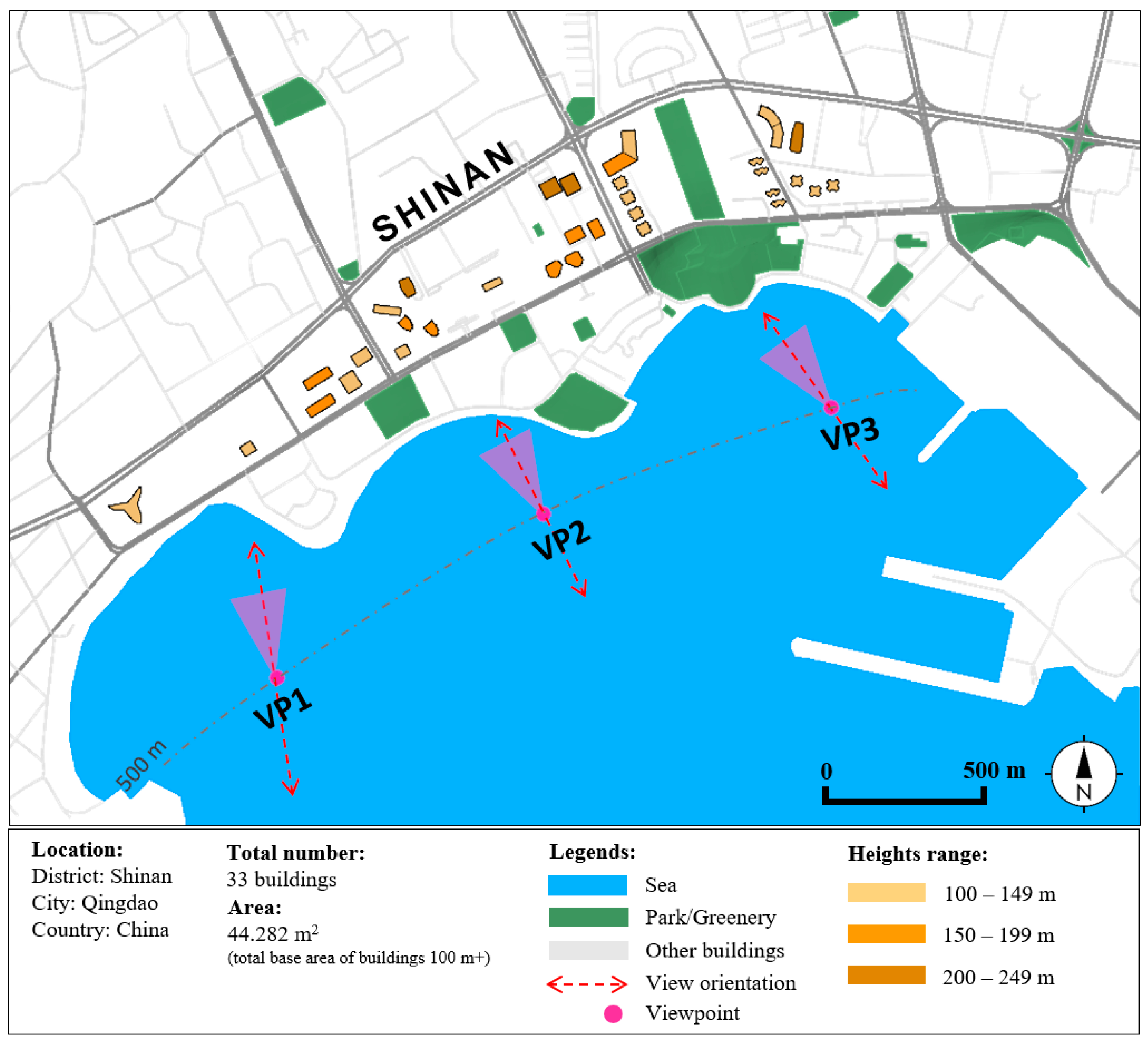
Viewpoint—A set of points defining the observer’s location, from which the buildings can be seen. In the case of tall building clusters that can strongly impact the view from major roads (e.g., Mega Kuningan), the observers’ locations were categorized into five viewpoints that represent the views from three major roads and two intersections. For the case of tall buildings on a waterfront, the viewpoints were derived from across the river (Lujiazui) and from the sea (Qingdao), where the skyline view is highly appreciated. In both clusters, the observer’s locations were categorized into three viewpoints facing the cluster from the edge and center of the cluster.
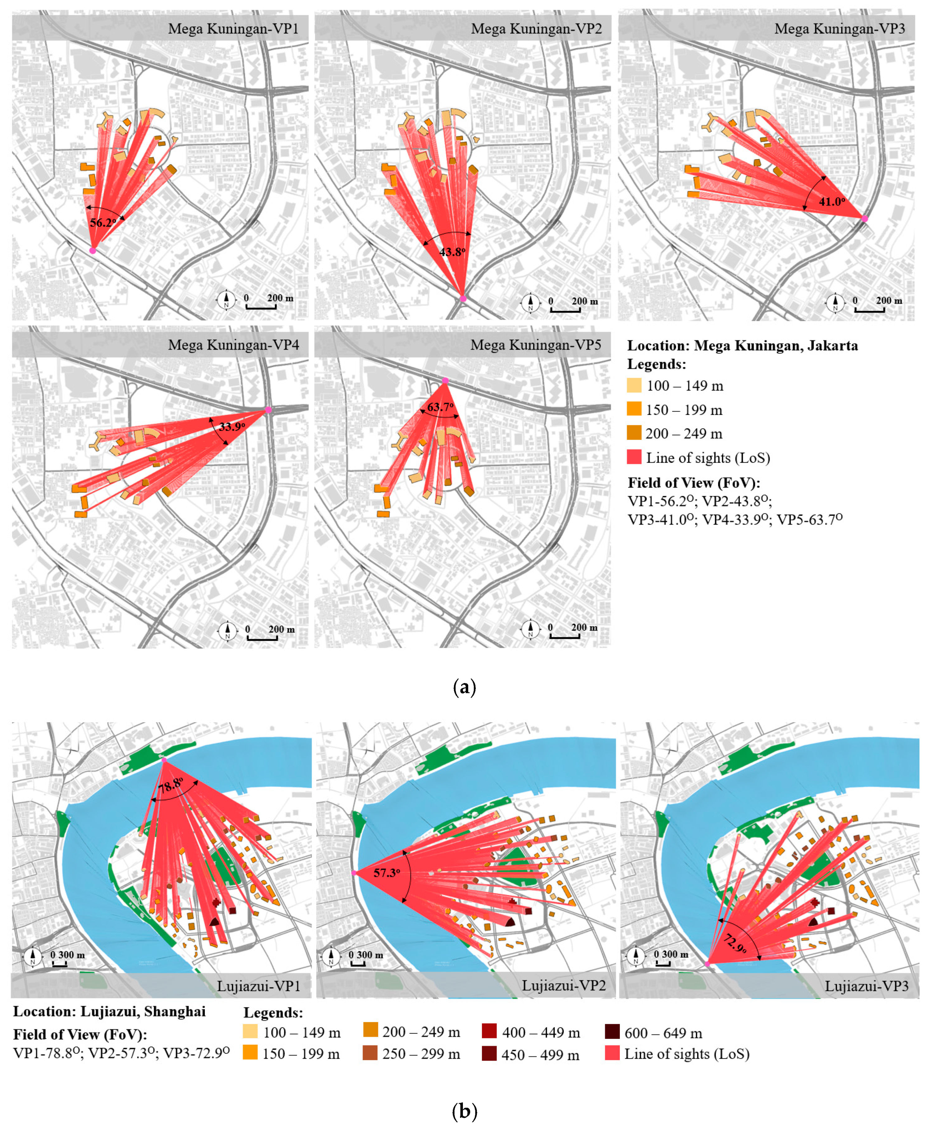
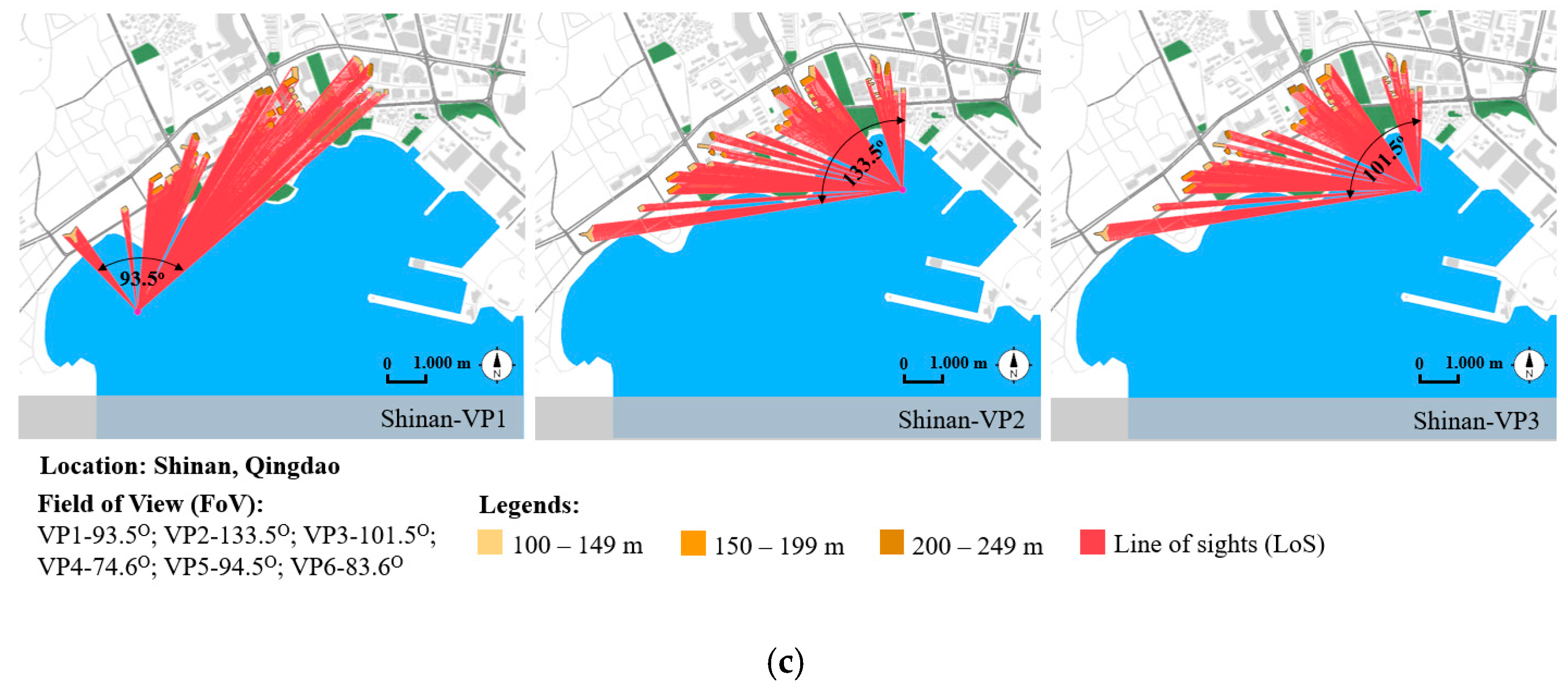
The building model unit was divided into grid cells. The grid size was set to a small number (5.0); a smaller grid size resulted in higher resolution and accuracy of the analysis. The visibility was derived from the unobstructed connection between the grid points of the input geometry and the viewpoint, thus forming the line of sight (LoS) (
Figure 2). The output was presented in terms of the percentage of the visible LoS. The percent visibility is defined as the percentage of the area of visible surfaces, which are constructed by visible arrays of the LoS, of the total area of building surfaces. The percent visibility from each viewpoint can be obtained by changing the output of the “view analysis” component with some algorithms, as shown in
Figure 3.
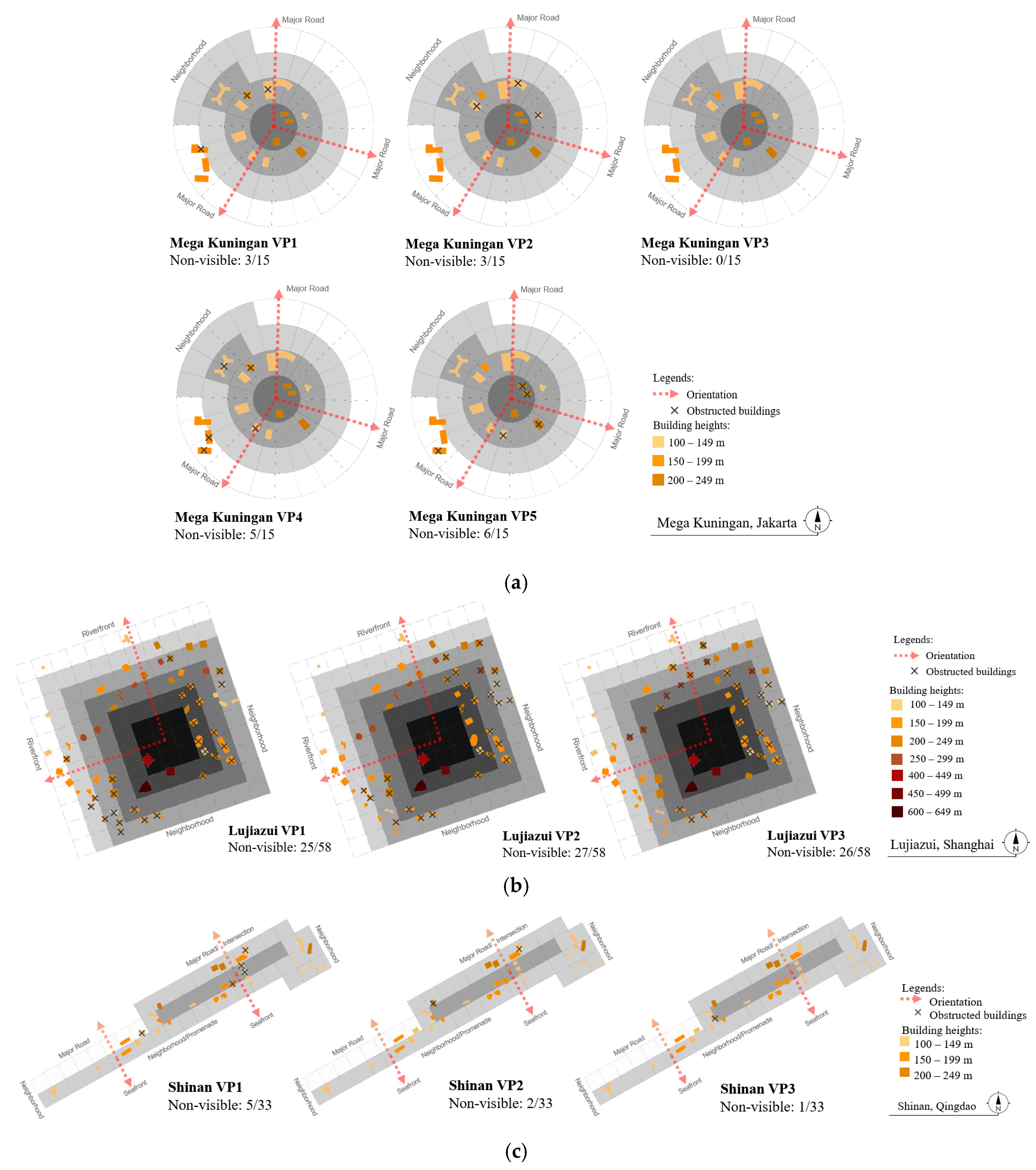
Second, to analyze the height transition, a mapping method was used to identify the buildings in the skyline obstructed from the observer’s viewpoint. On the grid map, the locations of tall buildings in a cluster were divided into different gradations, which were disclosed to the borders of the cluster area. The bright color grids represented the periphery area of the cluster and the gradual to the dark color grids showed the area toward the inner region or center of the cluster. The X code defines the building that is not visible or obstructed by other tall buildings. From this analysis, the visibility of each height category (100 m+, 150 m+, etc.) was determined by the percentage of visible buildings relative to the total number of buildings in each category. Thus, the quality of the height transition could be determined by the total number of unobstructed the buildings within the cluster were.
6. Discussion
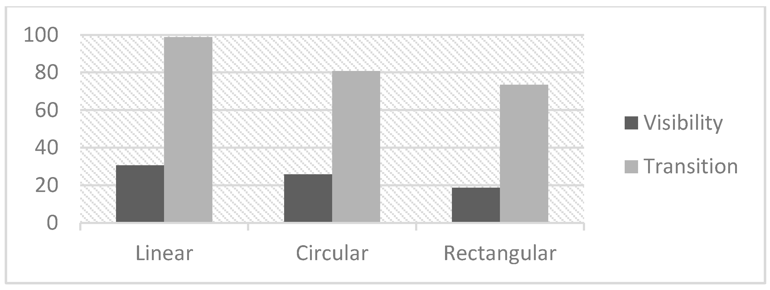
In addition to height transition, the visibility of tall buildings in clusters on the skyline was analyzed to compare clusters in circular, rectangular, and linear geographical areas. As can be seen, the transition in tall building heights within the cluster is quite influential on the degree of visibility. The percentage of unobstructed buildings within the skyline from the viewpoints had the same proportion as the degree of visibility between the three spatial layouts (
Figure 8). In the results, the linear cluster had a high proportion of visibility, and many buildings were not obstructed. The rectangular cluster had a lower proportion than the others.
Principally, grouping the elements that are close together and distinguishing them from the others is a very powerful strategy in providing coherence in the visual environment [
22]. Grouping tall buildings by vertical heights that are distinguished from their surroundings reinforces visual interest within the urban landscape. Uncontrolled heterogeneous heights and inappropriate locations within context tend to bring chaos to the context and features of the skyline. The concept of tall building clusters with regard to height transition creates a positive effect not only on the skyline, but also on their environment. Tall buildings are usually located in urban centers or regeneration districts. Hence, the gradation in heights from the center to the periphery of the cluster should be provided from the tallest to the shortest of the tall buildings. Consequent to this design, each tall building cluster has a visual hierarchy in relation to the skyline of the city [
23]. The presence of tall building clusters as a form of profile unity on the skyline should provide an attractive view and legibility of the district as an important area in the city based on their visibility.
The top part of tall buildings is a significant feature of the skyline. The visibility of the tallest building within the cluster can be a focal point that is equally important in terms of indicating the location, direction, and progress of one’s movement within the city. The legibility of the tallest building is also reinforced by the gradual height transition and observer’s distance. Each tall building cluster has its characteristics in a provided visual aspect from and to the cluster.
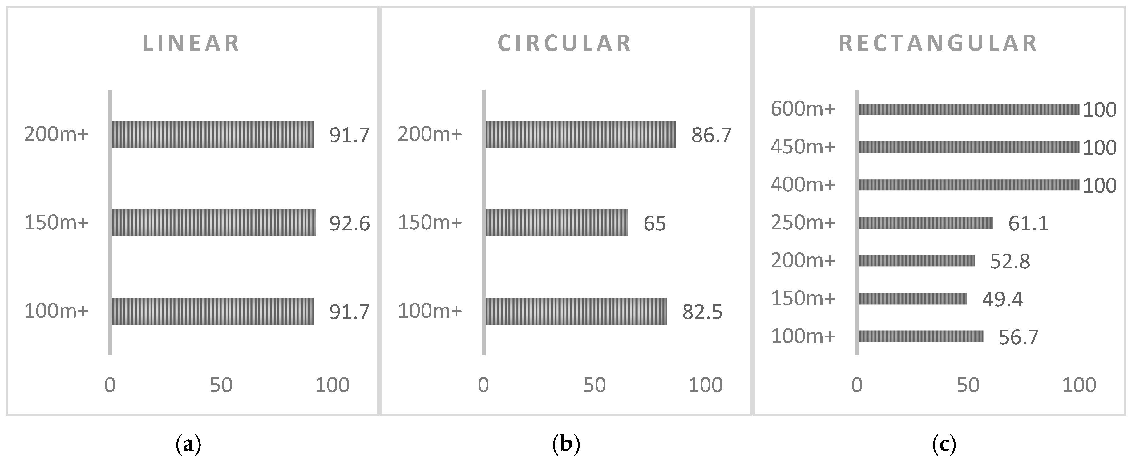
Linear organization is inherently flexible and can respond readily to various conditions of its site. Usually, linear organization is applied when adapting to changes in topography, maneuvering around a body of water, or following the axis along a street. Tall buildings in Shinan district are arranged in a linear site by the positions of buildings in relation to the road and coastline. The linear cluster, as exemplified by the case of Shinan district, places tall buildings relative to one entity with the same orientation. As a result, this cluster had a similar relative proportion of visibility in every classification of the height (
Figure 9a). Conversely, circular and rectangular clusters might pose in obtaining an equal proportion of visibility in all building height categories when the visual orientation is distributed in more than one direction.
The circle is a centralized, introverted figure that is normally stable and self-centering in its environments [
24]. Placing a circle in the center of a cluster reinforces its inherent centrality. Mega Kuningan district has implemented this concept into its masterplan and is placing some landmark buildings in the center to emphasize a center of attention to the area. Moreover, the view of the circular cluster of Mega Kuningan is highly accessible from the major road. Bounded by three major roads, as though it is a circular organization of tall buildings, it has strong geometric basics for providing views to and from any direction. Despite this, differences in height with other tall buildings should be considered to strengthen their visibility from the ground level. A difference in height within 50 m between tall buildings that are adjacent to other tall buildings in a transition to the higher or lower order within the cluster apparently does not provide a visibly distinct height from the ground level. Even buildings that are actually taller than buildings on the periphery are not visible. As in the case of Mega Kuningan, from one of the viewpoints at the ground level, the view of buildings at 100 m+ were visually more dominant. Moreover, the distance of an observer that is too close will reduce the visibility of buildings at 200 m+ (
Figure 9b).
The rectangular cluster of Lujiazui also had heights in transition from the inner region to the periphery to enhance the visual hierarchy. The three landmark buildings at 400 m+, 450 m+, and 600 m+ are located within the cluster; even though it is imprecisely in the center, it is still legible as the highest point on the skyline. Furthermore, a larger height that differs from other tall buildings (
Figure 9c) significantly provides a high portion to the visibility of the landmark buildings as a focal point of the cluster.
There are some possible limitations in this study. First, the data of the sizes of tall buildings were derived from the Open Street Map, which may not depict the width and the shape precisely. Therefore, the original width and shape could be smaller or larger than those depicted in the OSM, which will impact the percent of viewable area; however, the results only differed by a small percentage. Then, the comparison of the spatial layout of tall building clusters was derived from three case studies of different locations. Extra examples of other locations with similar or different cluster shapes could enhance the comparative result. Moreover, due to the limited time for the research and data collection, the simulation in this study was derived from the viewpoints considered representative of each side of the tall building cluster. The visibility level may vary depending on the position of the viewpoint. Therefore, adding more viewpoints will yield a more precise percent visibility.
A tall building cluster is particularly appropriate in city center sites, where their density and prominence can enhance the vitality and wellbeing of the city. It is important to note that although it is vital that tall buildings need to work for the observer in terms of their height and spatial layout, it is equally important that the buildings work successfully for their occupants. Different heights of tall buildings will have different impacts and positive or negative connotations for a given site. Consideration of the most appropriate form of development should be explored at the development stage. Tall buildings can fail if one or more potentially negative attributes prevail (e.g., inappropriate position of the buildings with various heights). If these negative attributes were removed, it is generally agreed that with the right arrangement of building heights, a well-designed tall building cluster could make a positive contribution to the skyline and act as a catalyst for the city’s image and branding.

