Voxel-Based Roadway Terrain Risk Modeling and Traversability Assessment in Underground Coal Mines
Abstract
1. Introduction
- A dust filtering algorithm based on visual fusion and spatio-temporal geometric particle filtering is proposed. The particle filter was enhanced through spatial neighborhood covariance smoothing and temporal consistency constraints; dust particles were identified via multidimensional state estimation within the particle filter, while visual image features were integrated to suppress false dust detection.
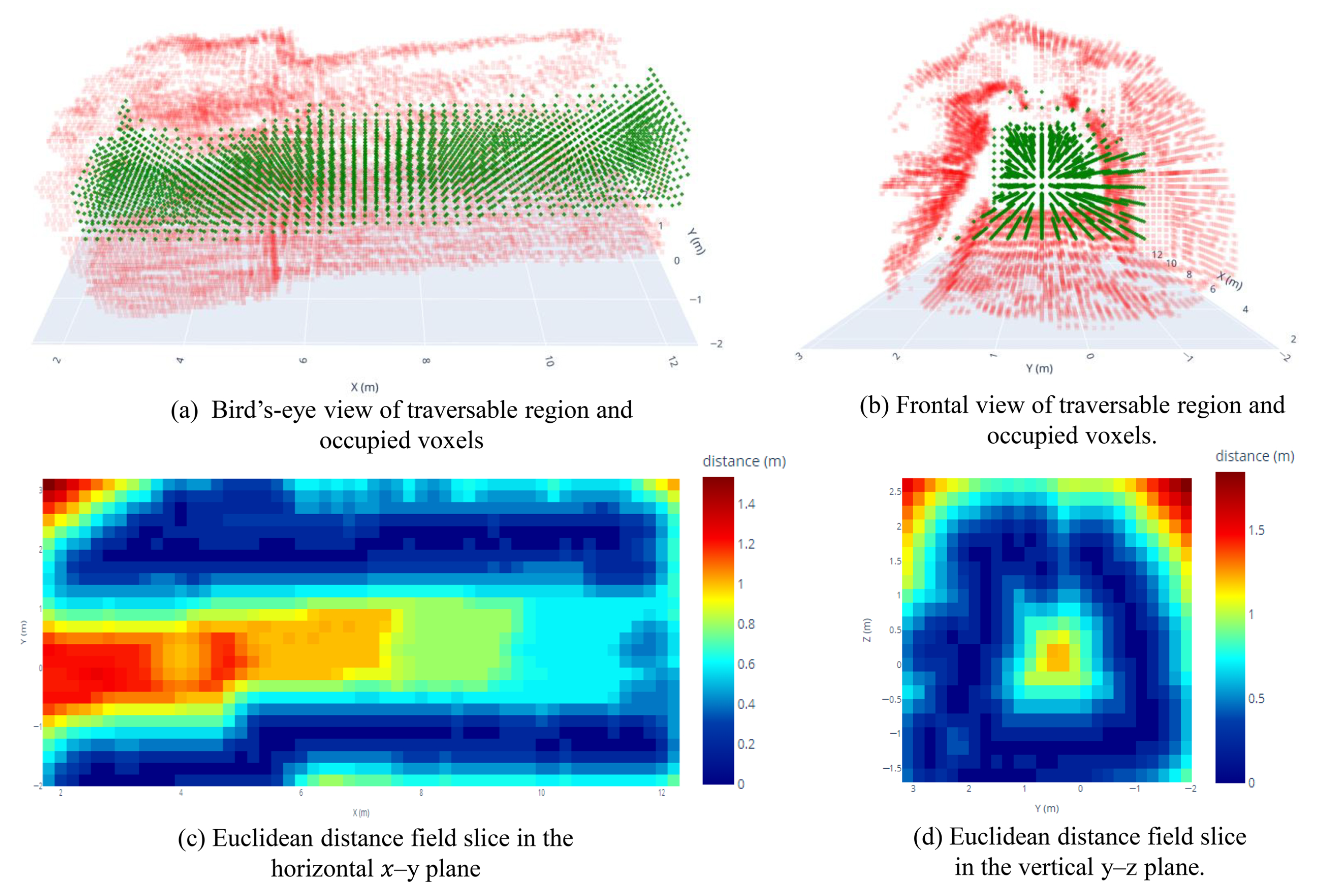
- A multidimensional D-S fusion algorithm for assessing tunnel terrain and passability risks is proposed. Dempster–Shafer (D-S) evidence theory is an evidence fusion framework for handling uncertain information, based on basic probability assignment and Dempster’s combination rule [22,23]. Tunnel spatial constraints are decomposed into multidimensional risk information, which is then fused using D-S theory to construct a 3D risk voxel model. Based on this terrain risk voxel model and vehicle dimension data, the passable space within the tunnel is extracted. The characteristics of this passable space are analyzed to quantitatively evaluate passability risks.
2. Dust Filtering Algorithm Based on Visual Fusion and Spatio-Temporal Geometric Particle Filtering
2.1. Spatio-Temporal Geometric Particle Filter
2.1.1. Overview of Particle Filters
- Step 1.
- Initialization phase: Generate an initial set of particles based on the prior distribution.
- Step 2.
- Prediction phase: Predict the particle state according to the system model
- Step 3.
- Update phase: Using the observed data to update the particle weights
- Step 4.
- Resampling phase: Resampling to avoid particle degradation when the effective particle count is too low
- Step 5.
- State estimation: The optimal state estimate is obtained by weighted averaging
2.1.2. Particle State Modeling via Fusion of Temporal and Geometric Features
2.1.3. Particle Filtering Mechanism for Spatially Adaptive Neighborhood Covariance Updating
- Step 1.
- Determine the spatial neighborhood of the target voxel and obtain the covariance matrix of the voxels in the neighborhood. In order to enhance the spatial continuity and robustness of voxel state estimation, an adaptive neighborhood search strategy is adopted: when the number of neighbors of a voxel is insufficient (|N(v)| < 3), the search radius is dynamically enlarged to ensure that each voxel can effectively fuse sufficient neighborhood information during the state update process, so as to inhibit the influence of local noise on the filtering results and improve the estimation accuracy and spatial consistency.
- Step 2.
- Calculate the mean of the covariance matrix in the neighborhood as a benchmark for spatial adaptive smoothing
- Step 3.
- Utilize to update the covariance matrix for the current voxel:where is the smoothing factor. is the original covariance matrix of the current voxel, and is the average of the covariance matrices in the neighborhood.
- Step 4.
- Further spatial smoothing of particle weights is achieved by the weight adjustment formula:where denotes the average particle weight of neighboring voxels and is the spatial smoothing strength parameter.
2.2. Voxel Recovery Method for Misfiltered Data Based on Image Feature Fusion
2.2.1. Voxel-Pixel Mapping
- Step 1.
- Coordinate system transformation. Given the 3D coordinates of a voxel in the world coordinate system , it is first transformed to the camera coordinate system by means of an external reference matrix as in Equation (5).where is the rotation matrix, is the translation vector, and is the 3D coordinates in the camera coordinate system.
- Step 2.
- Perspective projection transformation. The 3D points under the camera coordinate system are mapped to the normalized image plane by the perspective projection model:where is the normalized image coordinates and is the depth value in the camera coordinate system.
- Step 3.
- Image coordinate mapping. The corrected normalized coordinates are converted to pixel coordinates by means of the camera internal reference matrix:where is the camera internal reference matrix, is the focal length parameter, is the principal point coordinates, and is the final pixel coordinates.
2.2.2. Image Feature Extraction and Analysis
- (1)
- Edge characterization. The Sobel gradient operator is utilized to compute the gradient magnitude and directional consistency within the local region, where the gradient magnitude is defined as:Gradient direction consistency is quantified by the entropy value of the gradient direction distribution within a localized window, where a lower entropy value represents a more concentrated edge direction and a more significant structural feature in the region.
- (2)
- Texture characterization. A combination of statistical and structural methods is used to calculate the complexity of local regions of an image, mainly including gray scale standard deviation, which is used to describe the local contrast; Laplace energy, which reflects the complexity of the texture of the local region; the density of the edge points in the region, which is measured by using the Canny operator; and the gray scale entropy, which is used to measure the complexity of the gray scale distribution. The texture complexity feature is obtained by the fusion of these metrics.
- (3)
- Color features. Color change features reflect the complexity of the color distribution inside the region, which helps to distinguish the background from the object structure from the image, and the color features are obtained by calculating the combination of variance and color entropy of the color channels.On the basis of image features, a voxel recovery score evaluation mechanism is constructed by fusing the intensity, geometric structure features, and point density of the point cloud to discriminate whether the filtered voxels are mistakenly deleted or not. The recovery score of voxels is defined as a linear weighted sum of various types of features:where E: edge feature score; T: texture complexity score; C: color variation score; I: voxel point cloud intensity score; G: geometric structure feature score (evaluated as a combination of linearity, flatness, and sphericity); and D: normalized voxel point density score. is the weighting parameter for each feature.
3. Tunnel Terrain—Access Risk Assessment
3.1. Construction of 3D Risk Voxels for Tunnel Topography Based on D-S Theory
3.1.1. Theoretical Foundations of D-S Theory
3.1.2. Construction of Three-Dimensional Constrained Evidence Sources
- (1)
- Evidence Source Risk Value Calculation
- (2)
- Calculation of the reliability of sources of evidence
- (3)
- Cognitive Uncertainty Calculation of Evidence Sources
3.1.3. BPA Construction Method for Confidence Attenuation
3.1.4. 3D Risk Voxel Raster Construction for Tunnel Topography
- Step 1.
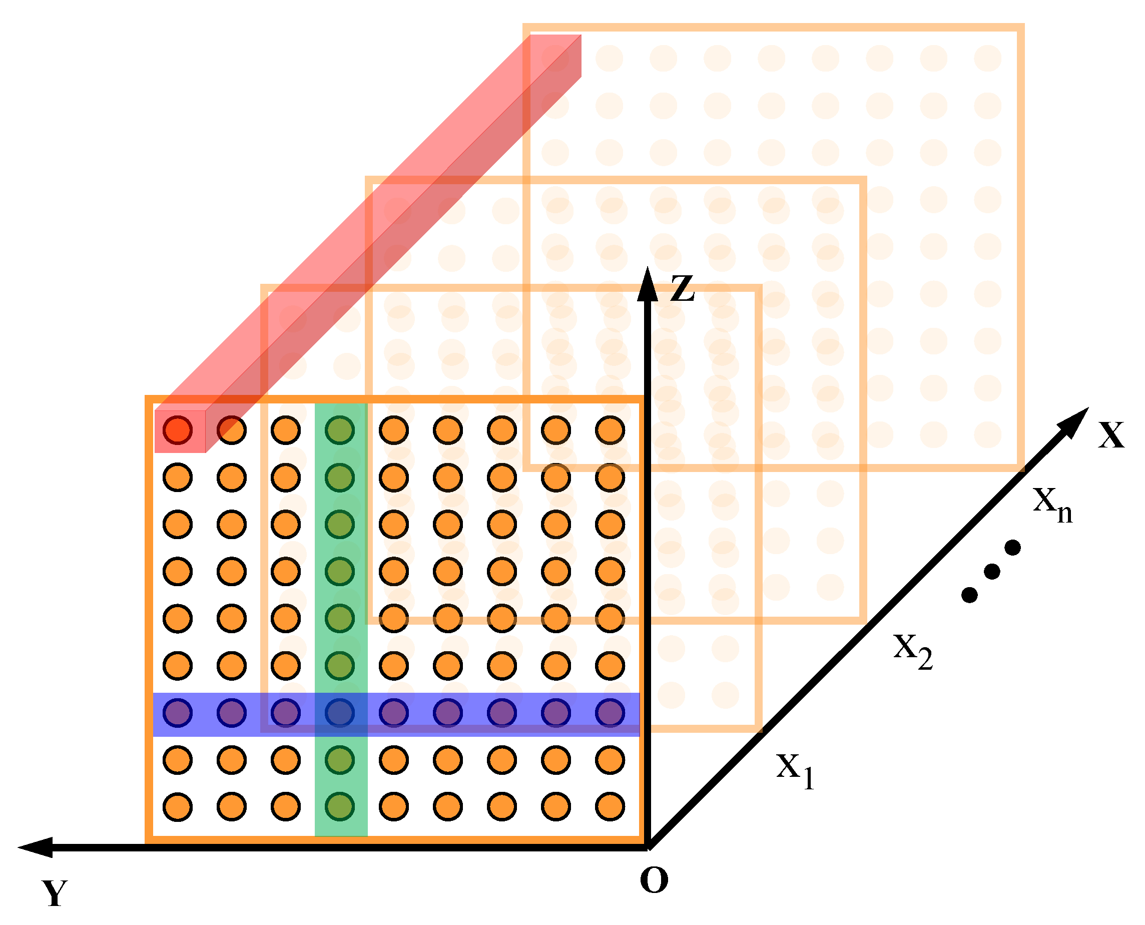
- Spatial meshing. A 3D evaluation grid covering the entire lane space is first established. Based on the boundary range of the voxel data, generate a regular 3D grid point set .
- Step 2.
- Multi-source evidence allocation mechanism. For each grid point , organized along X layers, a two-stage matching strategy is used to obtain risk information.The purpose of the first stage is to determine the X-layer index corresponding to the grid points. The height and width evidence X indexing methods correspond to Equation X. The distance evidence X layer indexing methods correspond to the following equations:The purpose of the second stage is to find the corresponding risk values within the identified X layers. Height evidence, width evidence, and distance evidence are indexed in the following manner, respectively:where are the preset X-coordinate sampling layers, and , , are the height, width, and distance evidence data structures organized by X layers, respectively. This two-stage strategy ensures spatial localization and improves computational efficiency.
- Step 3.
- DS theory multi-source fusion. The Dempster combination rule is used to fuse the evidence information in two steps, first fusing the height constraint information with the width constraint information, and then fusing with the distance constraint information to obtain the result:where the conflict factor is calculated to take into account inconsistencies between sources of evidence: .The extreme conflict handling mechanism is enabled when , assigning all masses to the UNKNOWN set.
- Step 4.
- Risk estimation based on Dempster–Shafer theory. Based on the fusion result of Step 3, a three-focal-set basic probability assignment (BPA) is obtained: Following Dempster–Shafer theory, the danger is characterized by the belief interval where , We adopt the midpoint of this interval as the single-valued risk estimate, which avoids undue conservatism or optimism while explicitly accounting for epistemic uncertainty.
3.2. Risk Assessment of Vehicle Accessibility
3.2.1. Three-Dimensional Passable Space Recognition Extraction
3.2.2. Risk Assessment of Accessible Areas
4. Experiments and Disscusscion
4.1. Performance Evaluation of Dust Filtering Algorithms
4.1.1. Overall Analysis
4.1.2. Scenario Analysis
4.2. Risk Assessment Algorithm Performance Test
4.2.1. Terrain Risk Assessment Performance Analysis
4.2.2. Accessible Risk Assessment Analysis
5. Conclusions
- (1)
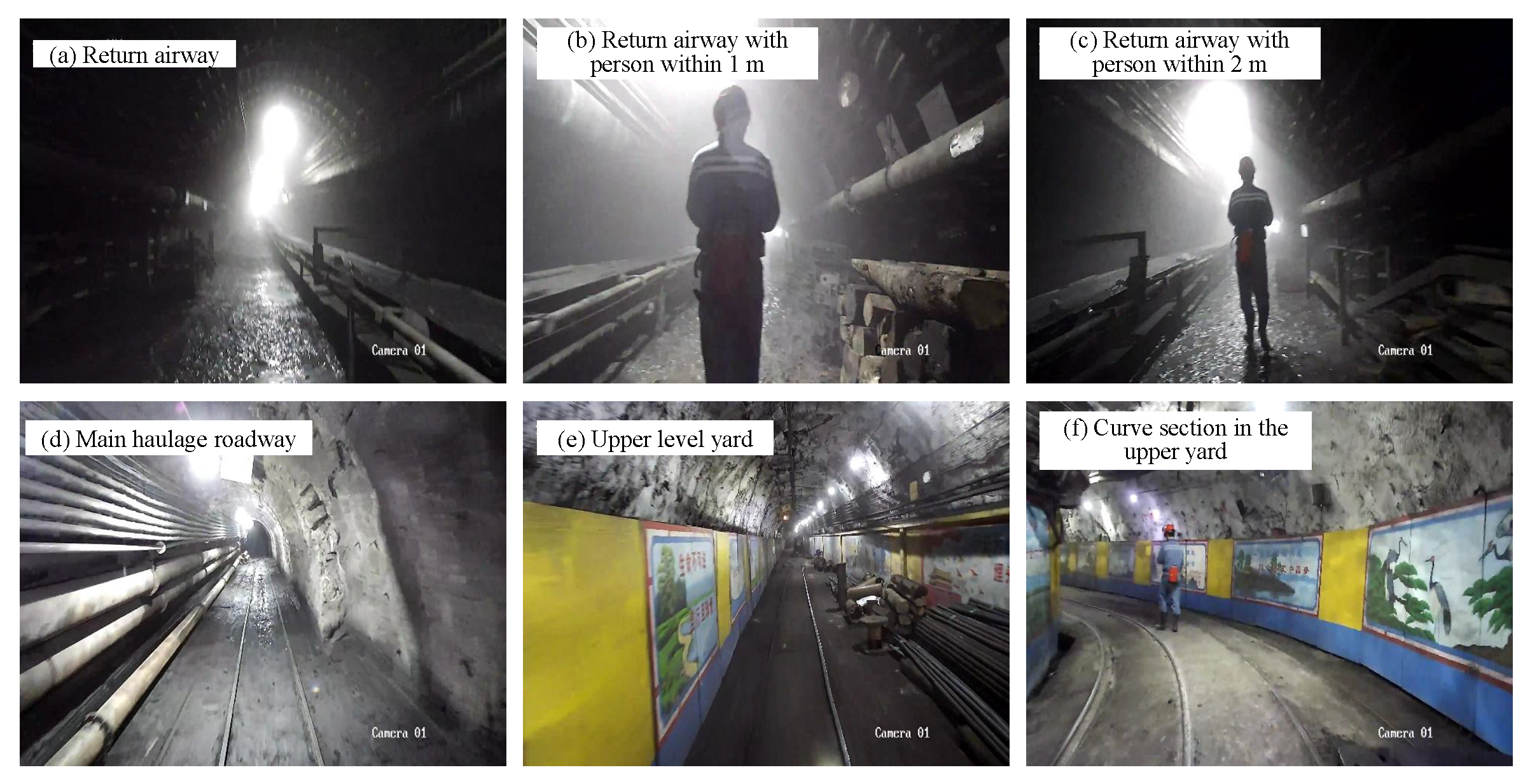
- By improving the particle filter and adopting a two-stage roadway dust filtering strategy that fuses visual-modality data, the proposed method effectively removes dust-noise point clouds in underground roadways. Across six representative underground scenarios, the average dust removal accuracy reaches 96.70%, demonstrating the effectiveness of the two-stage dust filtering strategy.
- (2)
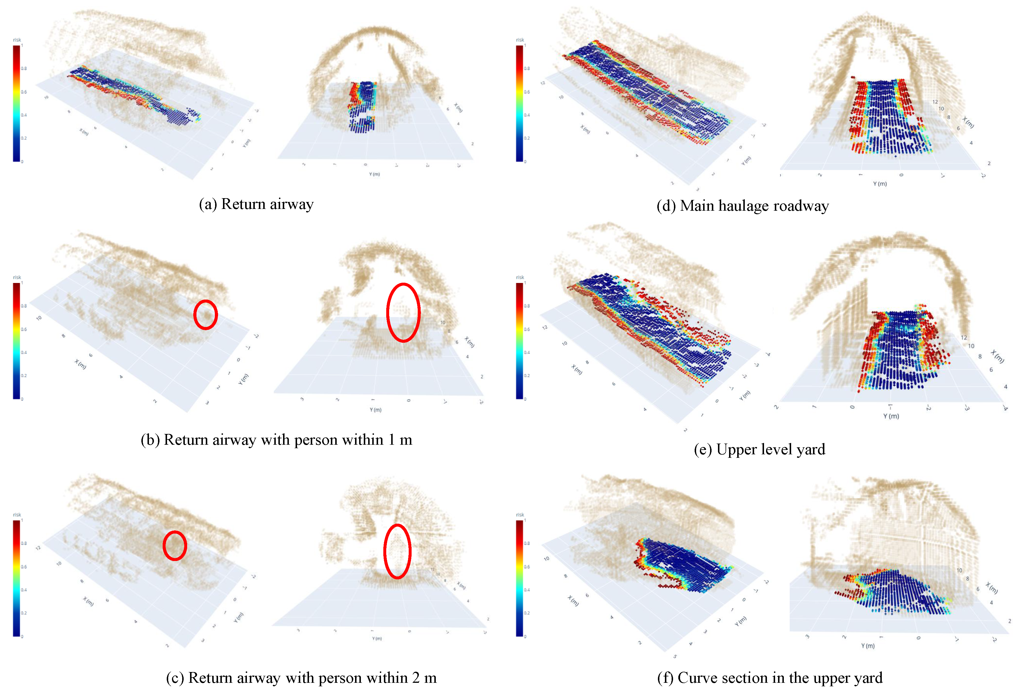
- Considering the three-dimensional spatial constraints of tunnel topography, we fuse multidimensional information using D-S evidence theory to obtain a robust and continuous risk field. Compared with the arithmetic averaging method, Bayesian inference method, and entropy-weighted method, the proposed terrain-risk evaluation strategy achieves the best performance in both risk differentiation (RD) and risk distribution continuity (RDC) across all scenarios.
- (3)
- Based on the constructed 3D risk voxels, we extract the roadway passable space and perform quantitative assessment of roadway accessibility risk using the projection features of the passable space onto the terrain surface. Results in underground scenes indicate that the proposed approach effectively quantifies roadway accessibility risk.
Author Contributions
Funding
Institutional Review Board Statement
Informed Consent Statement
Data Availability Statement
Acknowledgments
Conflicts of Interest
References
- Long, M.; Schafrik, S.; Kolapo, P.; Agioutantis, Z.; Sottile, J. Equipment and Operations Automation in Mining: A Review. Machines 2024, 12, 713. [Google Scholar] [CrossRef]
- Wang, G.; Ren, H.; Zhao, G.; Zhang, D.; Wen, Z.; Meng, L.; Gong, S. Research and Practice of Intelligent Coal Mine Technology Systems in China. Int. J. Coal Sci. Technol. 2022, 9, 24. [Google Scholar] [CrossRef]
- Ge, S.; Wang, F.-Y.; Yang, J.; Ding, Z.; Wang, X.; Li, Y.; Teng, S.; Liu, Z.; Ai, Y.; Chen, L. Making Standards for Smart Mining Operations: Intelligent Vehicles for Autonomous Mining Transportation. IEEE Trans. Intell. Veh. 2022, 7, 413–416. [Google Scholar] [CrossRef]
- Li, J.-G.; Zhan, K. Intelligent Mining Technology for an Underground Metal Mine Based on Unmanned Equipment. Engineering 2018, 4, 381–391. [Google Scholar] [CrossRef]
- Xu, H.; Lai, X.; Shan, P.; Yang, Y.; Zhang, S.; Yan, B.; Zhang, Y.; Zhang, N. Energy Dissimilation Characteristics and Shock Mechanism of Coal–Rock Mass Induced in Steeply-Inclined Mining: Comparison Based on Physical Simulation and Numerical Calculation. Acta Geotech. 2023, 18, 843–864. [Google Scholar] [CrossRef]
- Shan, P.; Cui, F.; Cao, J.; Lai, X.; Sun, H.; Yang, Y. Testing on Fluid-Solid Coupling Characteristics of Fractured Coal–Rock Mass Considering Regional Geostress Characteristics. J. China Coal Soc. 2018, 43, 181–188. [Google Scholar] [CrossRef]
- Kang, J.; Li, M.; Mao, S.; Fan, Y.; Wu, Z.; Li, B. A Coal Mine Tunnel Deformation Detection Method Using Point Cloud Data. Sensors 2024, 24, 2299. [Google Scholar] [CrossRef] [PubMed]
- Si, L.; Wang, Z.; Liu, P.; Tan, C.; Chen, H.; Wei, D. A Novel Coal–Rock Recognition Method for Coal Mining Working Face Based on Laser Point Cloud Data. IEEE Trans. Instrum. Meas. 2021, 70, 1–18. [Google Scholar] [CrossRef]
- Chen, M.; Feng, Y.; Wang, S.; Liang, Q. A Mine Intersection Recognition Method Based on Geometric Invariant Point Detection Using 3D Point Cloud. IEEE Robot. Autom. Lett. 2022, 7, 11934–11941. [Google Scholar] [CrossRef]
- Baek, J.; Park, J.; Cho, S.; Lee, C. 3D Global Localization in the Underground Mine Environment Using Mobile LiDAR Mapping and Point Cloud Registration. Sensors 2022, 22, 2873. [Google Scholar] [CrossRef]
- Jiang, X.; Xie, Y.; Na, C.; Yu, W.; Meng, Y. Algorithm for Point Cloud Dust Filtering of LiDAR for Autonomous Vehicles in Mining Area. Sustainability 2024, 16, 2827. [Google Scholar] [CrossRef]
- Yang, J.; Luo, W.; Zhang, Y.; Chang, B.; Zheng, R.; Wu, M. Establishment of a coal mine roadway model based on point cloud feature matching. Math. Probl. Eng. 2022, 2022, 8809521. [Google Scholar] [CrossRef]
- Xing, Z.; Zhao, S.; Guo, W.; Meng, F.; Guo, X.; Wang, S.; He, H. Coal Resources under Carbon Peak: Segmentation of Massive Laser Point Clouds for Coal Mining in Underground Dusty Environments Using Integrated Graph Deep Learning Model. Energy 2023, 285, 128771. [Google Scholar] [CrossRef]
- Yang, X.; Lin, X.; Yao, W.; Ma, H.; Zheng, J.; Ma, B. A robust LiDAR SLAM method for underground coal mine robot with degenerated scene compensation. Remote Sens. 2022, 15, 186. [Google Scholar] [CrossRef]
- Zhang, X.; Yang, C.; Gu, Z.; Tang, C.; Zhu, Z.; Zhang, Y.; Qian, J.; Li, X. Obstacle Avoidance for Trackless Rubber-Tired Vehicle Based on Risk-Grid Particle Swarm Optimization in Confined Space of Deep Well. IEEE Trans. Veh. Technol. 2023, 72, 11291–11303. [Google Scholar] [CrossRef]
- Song, B.; Miao, H.; Xu, L. Path Planning for Coal Mine Robot via Improved Ant Colony Optimization Algorithm. Syst. Sci. Control Eng. 2021, 9, 283–289. [Google Scholar] [CrossRef]
- Zhang, C.; Yang, X.; Zhou, R.; Guo, Z. A Path Planning Method Based on Improved A* and Fuzzy Control DWA of Underground Mine Vehicles. Appl. Sci. 2024, 14, 3103. [Google Scholar] [CrossRef]
- Zhang, J.; Xu, Z.; Liu, H.; Zhu, X.; Lan, B. An Improved Hybrid Ant Colony Optimization and Genetic Algorithm for Multi-Map Path Planning of Rescuing Robots in Mine Disaster Scenario. Machines 2025, 13, 474. [Google Scholar] [CrossRef]
- Dixit, A.; Fan, D.D.; Otsu, K.; Dey, S.; Agha-Mohammadi, A.-A.; Burdick, J.W. STEP: Stochastic traversability evaluation and planning for risk-aware off-road navigation; results from the DARPA subterranean challenge. arXiv 2023, arXiv:2303.01614. [Google Scholar] [CrossRef]
- Fan, D.D.; Agha-Mohammadi, A.-A.; Theodorou, E.A. Learning risk-aware costmaps for traversability in challenging environments. IEEE Robot. Autom. Lett. 2022, 7, 2. [Google Scholar] [CrossRef]
- Patel, A.; Kanellakis, C.; Agha-Mohammadi, A.-A.; Nikolakopoulos, G. Traversability aware graph-based subterranean exploration with unmanned aerial vehicles. IFAC-PapersOnLine 2023, 56, 9263–9268. [Google Scholar] [CrossRef]
- Shafer, G. A Mathematical Theory of Evidence; Princeton University Press: Princeton, NJ, USA, 2020. [Google Scholar]
- Dempster, A.P. Upper and Lower Probabilities Induced by a Multivalued Mapping. In Classic Works of the Dempster-Shafer Theory of Belief Functions; Springer: Berlin/Heidelberg, Germany, 2008; pp. 57–72. [Google Scholar]
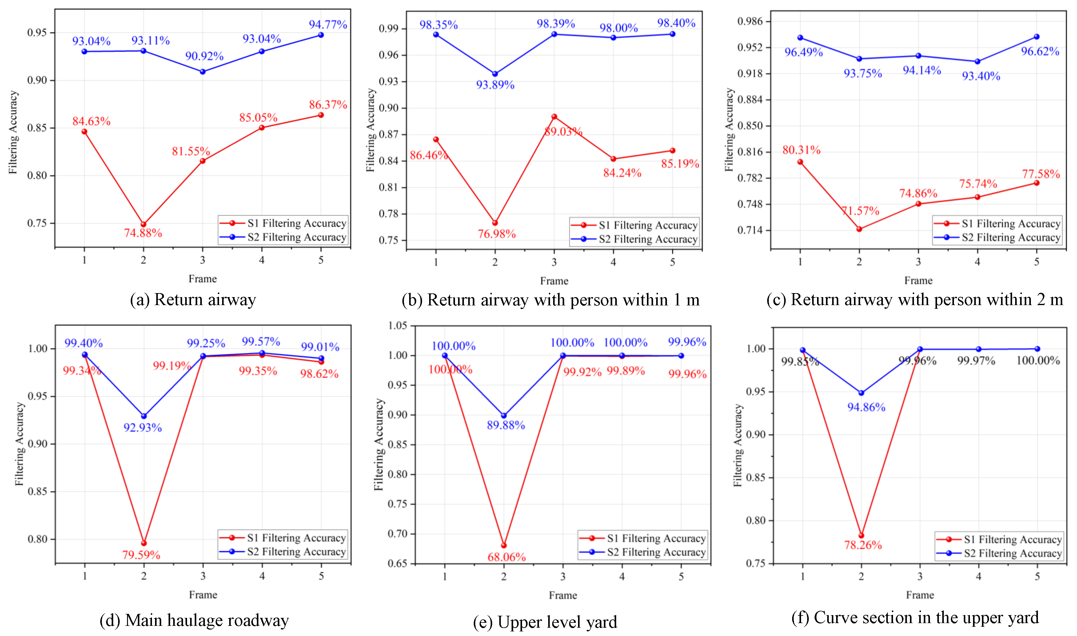
| Scene | VN | FP-I | FP-II | ACC-I (%) | ACC-II (%) | PG (%) |
|---|---|---|---|---|---|---|
| Return entry | 3915 | 687 | 275 | 82.49 | 92.97 | 10.48 |
| Return airway with person within 1 m | 2543 | 396 | 65 | 84.38 | 97.40 | 13.02 |
| Return airway with person within 2 m | 2791 | 668 | 142 | 76.01 | 94.88 | 18.87 |
| Main haulage roadway | 3299 | 166 | 68 | 95.22 | 98.03 | 2.81 |
| Upper-level yard | 2550 | 163 | 52 | 93.57 | 97.97 | 4.40 |
| Curve section in the upper yard | 2802 | 123 | 30 | 95.61 | 98.92 | 3.32 |
| Average | 2983 | 367 | 105 | 87.88 | 96.7 | 8.82 |
| Parameter | Value |
|---|---|
| Bounding volume size | (L × W × H) |
| Voxel resolution | (L × W × H) |
| Maximum voxel count | |
| Peak memory usage | |
| CPU | i7-12700H |
| Risk-evaluation runtime |
| Method | RA | RA-1m | RA-2m | MH | ULY | CS | ||||||
|---|---|---|---|---|---|---|---|---|---|---|---|---|
| RDC | RD | RDC | RD | RDC | RD | RDC | RD | RDC | RD | RDC | RD | |
| D-S Theory | 0.858 | 0.915 | 0.819 | 0.916 | 0.865 | 0.915 | 0.853 | 0.916 | 0.884 | 0.914 | 0.892 | 0.914 |
| Averaging Method | 0.851 | 0.896 | 0.788 | 0.900 | 0.847 | 0.899 | 0.837 | 0.908 | 0.870 | 0.888 | 0.879 | 0.893 |
| Conservative Max | 0.829 | 0.896 | 0.824 | 0.896 | 0.761 | 0.902 | 0.780 | 0.896 | 0.810 | 0.886 | 0.854 | 0.912 |
| Bayesian | 0.737 | 0.741 | 0.735 | 0.758 | 0.848 | 0.753 | 0.867 | 0.756 | 0.761 | 0.856 | 0.828 | 0.747 |
| Entropy Weighted | 0.851 | 0.894 | 0.795 | 0.899 | 0.848 | 0.899 | 0.837 | 0.909 | 0.870 | 0.888 | 0.881 | 0.886 |
| Method | Risk Distribution Continuity | Risk Differentiation | ||
|---|---|---|---|---|
| Mean | Std | Mean | Std | |
| D-S Theory | 0.861833 | 0.025841 | 0.915 | 0.000894 |
| Averaging Method | 0.845333 | 0.032042 | 0.897333 | 0.006802 |
| Conservative Max | 0.809667 | 0.034039 | 0.898 | 0.008579 |
| Bayesian | 0.8055 | 0.064289 | 0.752167 | 0.007278 |
| Entropy Weighted | 0.847 | 0.03002 | 0.895833 | 0.008424 |
Disclaimer/Publisher’s Note: The statements, opinions and data contained in all publications are solely those of the individual author(s) and contributor(s) and not of MDPI and/or the editor(s). MDPI and/or the editor(s) disclaim responsibility for any injury to people or property resulting from any ideas, methods, instructions or products referred to in the content. |
© 2025 by the authors. Licensee MDPI, Basel, Switzerland. This article is an open access article distributed under the terms and conditions of the Creative Commons Attribution (CC BY) license (https://creativecommons.org/licenses/by/4.0/).
Share and Cite
Yan, W.; Zhu, Z.; Zhang, Y.; Lu, H.; Xue, M.; Tang, Y.; Sun, S. Voxel-Based Roadway Terrain Risk Modeling and Traversability Assessment in Underground Coal Mines. Machines 2025, 13, 868. https://doi.org/10.3390/machines13090868
Yan W, Zhu Z, Zhang Y, Lu H, Xue M, Tang Y, Sun S. Voxel-Based Roadway Terrain Risk Modeling and Traversability Assessment in Underground Coal Mines. Machines. 2025; 13(9):868. https://doi.org/10.3390/machines13090868
Chicago/Turabian StyleYan, Wanzi, Zhencai Zhu, Yidong Zhang, Hao Lu, Minti Xue, Yu Tang, and Shaobo Sun. 2025. "Voxel-Based Roadway Terrain Risk Modeling and Traversability Assessment in Underground Coal Mines" Machines 13, no. 9: 868. https://doi.org/10.3390/machines13090868
APA StyleYan, W., Zhu, Z., Zhang, Y., Lu, H., Xue, M., Tang, Y., & Sun, S. (2025). Voxel-Based Roadway Terrain Risk Modeling and Traversability Assessment in Underground Coal Mines. Machines, 13(9), 868. https://doi.org/10.3390/machines13090868


