Review

Geodynamics and Oil and Gas Potential of the Yenisei-Khatanga Basin (Polar Siberia)

1
A.A. Trofimuk Institute of Petroleum Geology and Geophysics, Siberian Branch of the Russian Academy of Sciences, prosp. Akad. Koptyuga, 3, Novosibirsk 630090, Russia
2
Department of Geology and Geophysics, Novosibirsk State University, Pirogova st. 1, Novosibirsk 630090, Russia
*
Author to whom correspondence should be addressed.
Minerals 2018, 8(11), 510; https://doi.org/10.3390/min8110510
Submission received: 12 October 2018 / Revised: 2 November 2018 / Accepted: 3 November 2018 / Published: 6 November 2018
(This article belongs to the Special Issue Arctic Mineral Resources: Science and Technology)

Abstract

:
The geodynamic development of the north–western (Arctic) margin of the Siberian craton is comprehensively analyzed for the first time based on our database as well as on the analysis of published material, from Precambrian-Paleozoic and Mesozoic folded structures to the formation of the Mesozoic–Cenozoic Yenisei-Khatanga sedimentary basin. We identify the main stages of the region’s tectonic evolution related to collision and accretion processes, mainly subduction and rifting. It is demonstrated that the prototype of the Yenisei-Khatanga basin was a wide late Paleozoic foreland basin that extended from Southern Taimyr to the Tunguska syneclise and deepened towards Taimyr. The formation of the Yenisei-Khatanga basin, as well as of the West-Siberian basin, was due to continental rifting in the Permian–Triassic. The study describes the main oil and gas generating deposits of the basin, which are mainly Jurassic and Lower Cretaceous mudstones. It is shown that the Lower Cretaceous deposits contain 90% of known hydrocarbon reserves. These are mostly stacked reservoirs with gas, gas condensate and condensate with rims. The study also presents data on oil and gas reservoirs, plays and seals in the Triassic, Jurassic and Cretaceous complexes.

1. Introduction

The structures of the north–western margin of the Siberian craton have attracted the attention of geologists for over a hundred years [1,2,3,4,5,6,7,8,9,10,11,12,13,14,15] and many others. The earliest and most essential questions on the study area are: (a) How did the Taimyr-Severnaya Zemlya folded area form—a key structure of the Artic, and is it a part of the Siberian craton; (b) what are the sequence and stages of its formation, how is the formation of this folded area related to the formation of the Yenisei-Khatanga basin; (c) what serves as the basement for the latter. V.E. Khain wrote in his book “Tectonics of continents and oceans” (2001) [3]: “There is no doubt that the basin and the rift that generated it were emplaced within the Siberian craton, and that its territory has the same platform cover, since it also is present in Southern Taimyr. At the same time, it is supposed that in the zone of the Mesozoic basin there was a Riphean rift, and the Permian-Early Triassic rifting was preceded by arched uplift” [3] (p. 228). The significant remoteness of these structures, harsh climate conditions, minuscule amounts of geostructural, geochronological, geophysical investigations, and even less drilling works prevented researchers from building a noncontradictory model for the formation of this segment of the Earth’s lithosphere. Nonetheless, the interest in this region began to rise in the last decades. This was due to the need to estimate the oil and gas potential of this territory and to the discovery of the first seeps and deposits of petroleum, even though the Yenisei-Khatanga basin definitely does not have the same resource potential as its huge neighbor—the West Siberian basin [16].
In this paper we present our point of view on the geodynamic history of the north–western margin of the Siberian craton and the formation of the Yenisei-Khatanga basin. Our reconstructions generalize our own results obtained during many years of studies of the various geological structures of the Taimyr Peninsula and the Severnaya Zemlya Archipelago, as well as a body of modern geological, geophysical, geodynamic, paleomagnetic and petro-geochemical data. This includes materials of seismic surveys and drilling data in the Yenisei-Khatanga basin.
The Yenisei-Khatanga basin is located in the north–western part of the margin of the Siberian craton (Figure 1 and Figure 2). It extends for 900 km from the Gydan Bay of the Kara Sea in the west to the Khatanga Bay of the Laptev Sea in the east. From the north, the basin is bordered by the Byrranga Mountains of the Taimyr Peninsula, and from the south, by the Putorana Plateau. The maximum width of the basin reaches 450 km. The area of the basin is approximately 300,000 km2.
The Yenisei-Khatanga basin is a Permian–Cenozoic sedimentary basin dividing the northern margin of the Siberian craton and the Taimyr-Severnaya Zemlya fold-and-thrust belt (Figure 2 and Figure 3). The basin was formed above a continental rift of late Permian–Early Triassic age and filled with a 12 km thick sequence of terrigenous Triassic, Jurassic, Cretaceous and Cenozoic deposits. The northern and southern boundaries of the basin are traced along the wedging-out of its deposits [2,3]. In the western part the basin widens and transitions into the West Siberian sedimentary basin, with which it has a similar geological history. The margin between them is conventionally defined where the sub-latitudinal strikes of structures typical of the Yenisei-Khatanga basin change into sub-longitudinal ones that are typical of the West Siberian plate. In the east, the Yenisei-Khatanga basin is overlapped by the Laptev Sea [3].
The main information on the structure of the Mesozoic sedimentary infill of the Yenisei-Khatanga basin comes from seismic surveys and drilling. However, the focus areas of exploration activity including seismic lines and wells, are concentrated in the western part of the basin, which is directly adjacent to the West Siberian petroleum basin (Figure 4). Some wells have penetrated the full thickness of the Mesozoic deposits, including the volcanogenic-sedimentary Lower Triassic.
Seismic data, materials from well drilling, and geological analogies with surrounding structures show that the basement of the basin is composed of deformed siliceous-carbonate, carbonate, salt-bearing, terrigenous and terrigenous-volcanic complexes of a wide range of ages from the Mesoproterozoic to the Early Triassic [17,18,19,20]. The thickness of these units is significantly greater than the thickness of the sedimentary infill of the Yenisei-Khatanga basin itself [21,22]. The formation of these complexes is directly linked to the evolution of the northern margin of the Siberian craton: The change from a passive continental margin setting to an active one in the Neoproterozoic, followed by the formation of the Taimyr-Severnaya Zemlya fold-and-thrust belt in the late Paleozoic, and of the Yenisei-Khatanga rift system in the Permian–Triassic. Significant structural alterations at the Jurassic–Cretaceous boundary, the Paleogene and the Neogene, are also manifested within the Yenisei-Khatanga basin itself.

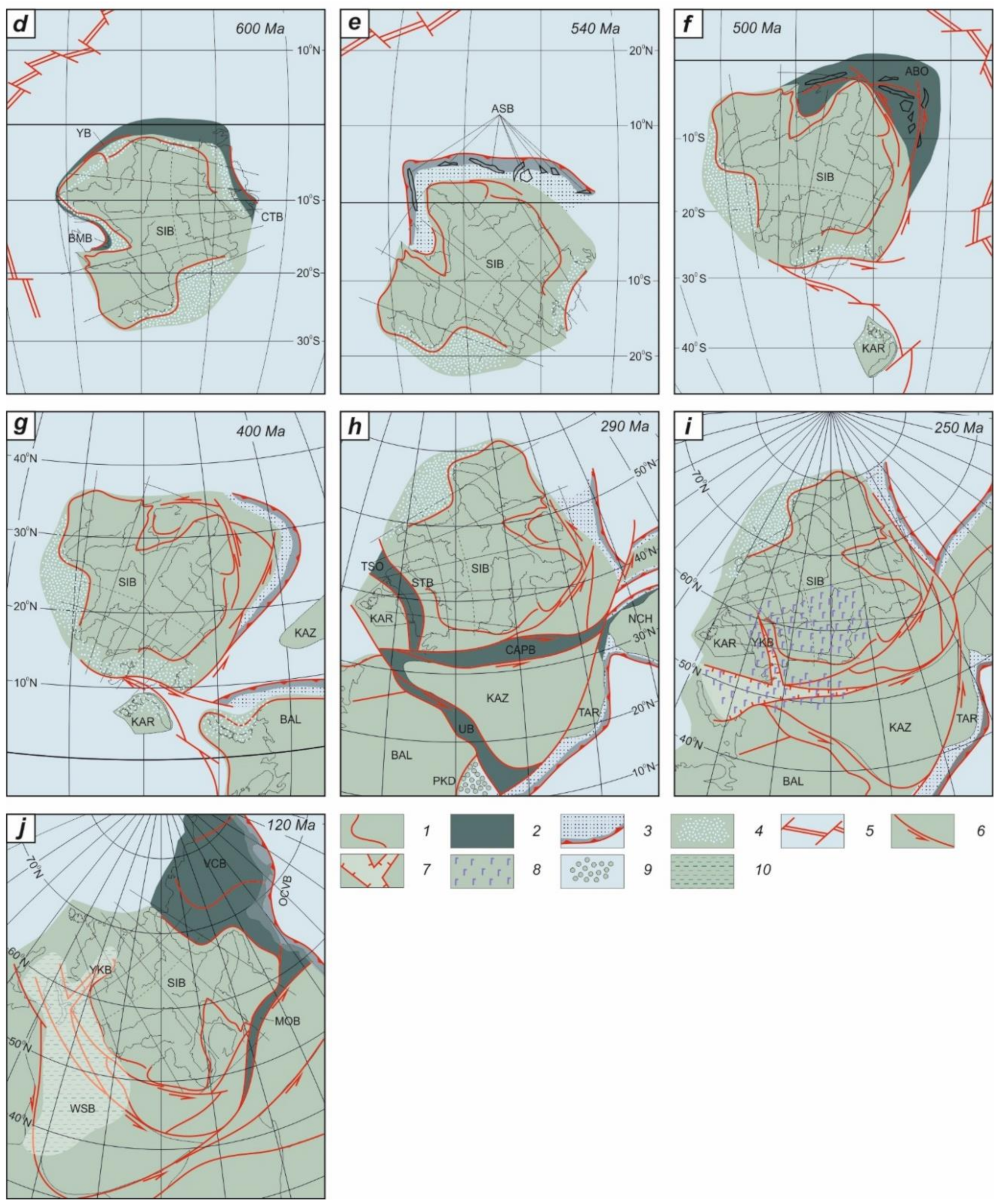
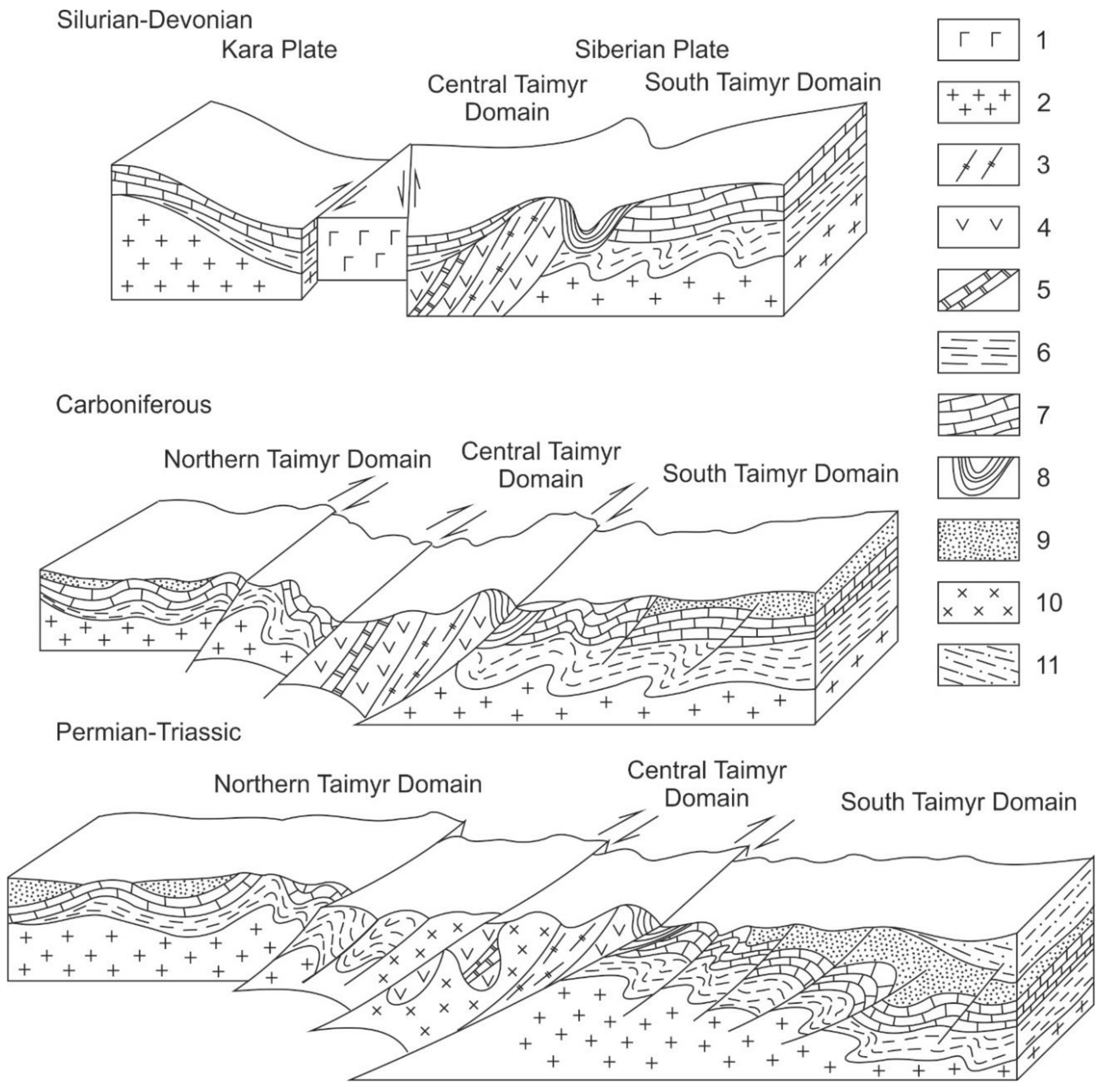
2. Tectonic Evolution of the North–Western Margin of the Siberian Craton and the Formation of the Basement of the Yenisei-Khatanga Basin in the Mesoproterozoic—Early Triassic

In the north the Yenisei-Khatanga basin borders to the southern margin of the Taimyr fold belt, and in the south to the northern part of the Siberian craton. Therefore, understanding the geological evolution from the Mesoproterozoic to the Triassic of these adjacent areas that form the basement for the Yenisei-Khatanga basin is highly significant [1,2,3,5,7].
According to results of deep seismic sounding, the Moho boundary depth under the Yenisei-Khatanga basin varies from 27–33 km in the central part to 36–38 km under the North-Siberian monocline and to 40–43 km under Taimyr [6,23,24]. The crystalline basement is supposedly composed of metamorphic rocks of Archean–Paleoproterozoic age. The depth of the basement surface varies from 6–7 to 12 km in different estimates [5,21].
To demonstrate the tectonic evolution of the north–western margin of the Siberian craton we propose our own version of paleotectonic reconstructions (Figure 5) [25]. The reconstructions that span the entire time interval from the end of the Mesoproterozoic to the Early Triassic are based on geological, geochronological, and paleomagnetic data for the territory of the Siberian craton and adjacent structures. These data are analyzed in detail in References [25,26,27,28,29]. These results take into account published global paleotectonic reconstructions [30,31,32,33], however, the central place here is occupied by the Siberian craton and the territory of the Yenisei-Khatanga basin. Therefore, some tectonic events in the margin of the craton that are not related to the evolution of the basement of the Yenisei-Khatanga basin are not reflected in our reconstructions. The quantity and quality of paleomagnetic information on the craton and the terranes of its boundaries is not the same for the time slices presented in the figure. Some are well characterized, while others, only in general traits. Nonetheless, the general trends of tectonic development of the region are reconstructed quite clearly. Together with additional geological indicators, this fully compensates the lack of some paleomagnetic data.
According to available geological data and paleogeographic (paleogeodynamic) reconstructions (Figure 5a), the north–western margin of the Siberian craton was a passive continental margin in the Mesoproterozoic–early Neoproterozoic [5,6,34,35,36], as were its western and eastern margins [37,38,39]. The composition of Mesoproterozoic deposits, judging from coeval formations of the Siberian craton, was siliceous-carbonate, terrigenous and carbonate, and their thickness reached 2–3 km [17]. Recent common depth point data indicate that the thickness of this sequence in the northern margin of the Siberian craton is up to 12 km (Figure 6).
However, as early as the early Neoproterozoic, an island arc system started forming near the north–western margin of Siberia, which means the passive continental margin transformed into an active one (Figure 5a–c) [25,28,29,40,41,42,43]. Ophiolite and island arcs continued forming here until the end of the Neoproterozoic in the Chelyuskin and Stanovoy belt (750–730 Ma) and 660 Ma in the Ust-Taimyr belt. Then, during the Ediacaran they accreted and were included into the Siberian craton as the composite Central Taimyr accretionary terrane [44] (Figure 2 and Figure 5d). The age of this accretion event is substantiated by isotope-geochemical data (Sm–Nd, Rb–Sr, Ar–Ar methods) for garnet amphibolites (606–570 Ma) occurring in the floor of the allochthon in the juncture zone of the Central and Southern Taimyr units [5,45]. This development stage of the active continental margin ended with rifting on the margin of the continent accompanied by the outpouring of thin trachybasalt and basalt flows, often with pillow and rope jointing, as well as rhyolites and felsites. In addition to these effusive rocks, the section includes corresponding tuffs. Volcanics contain tuff conglomerates, gravelstones, sandstones often with red coloration. Gabbro dikes have been identified intruding the underlying carbonate rocks. Many paleovolcanos have been identified in the axial part of the Central Taimyr zone, in the north– eastern end of Cape Chelyuskin, and Cape Khariton Laptev [4,46,47]. The development of the active continental margin ended in deformation of Meso-Neoproterozoic deposits, uplift of the region, and a nondepositional hiatus [39,48].
From the Ediacaran to the early Carboniferous the 5–6 km thick sedimentary sequence of the platform cover accumulated on the north–western passive continental margin of the Siberian craton (Figure 5e–g). It is composed of mainly carbonate, carbonate-terrigenous and salt bearing formations (Figure 3 and Figure 6). Periodic transitions from shallow marine sedimentation to a continental one caused hiatuses in deposition and washing out of lower deposits, which is indicated by unconformities on various stratigraphic levels. Passive margin complexes are traced in the basement of the Yenisei-Khatanga basin further to the north in the structure of the Southern and Central Taimyr zones [1,17,19,20,21,49]. Marine limestones, dolomites, marls, mudstones of the upper Cambrian, Ordovician, and Silurian have been penetrated on the Yenisei-Khatanga basin by the Tochino well (570–2002 m interval) in the south-western part of the basin [18].
At the same time with the accumulation of shallow marine carbonate and carbonate-terrigenous deposits, in the late Cambrian–Ordovician a deep water (over 750 m) elongated basin began forming between the Central and Southern Taimyr [1,3]. The axis of this SW–NE oriented basin was located southerly of the suture between the Central Taimyr accretionary terrane and the continent, in the frontal part of the large Pyasina-Faddey thrust. This means that the basin was formed in the front of the Neoproterozoic fold belt that was the result of accretion-type orogeny. In this basin, black graptolite shales accumulated with interlayers of dark bituminous limestones containing pteropod fauna, with a total thickness of 1.3–2.0 km. To the south of the basin, on the shelf, limestones and dolomites were deposited with abundant fauna of brachiopods, gastropods, bryozoans, corals and other shallow water benthic organisms [46].
During the Silurian and Devonian, the region south of the southern margin of the Taimyr fold belt was occupied by the formation of a Lower–Middle Devonian evaporite salt bearing formation, which was overlain by a carbonate (dolomites, limestones) shallow marine formation accumulated in the north. The position of the deep-water basin did not change, and they were filled with a Silurian black shale formation, and a Devonian argillaceous-carbonate formation. The deep-water basin existed for over 100 million years, and the subsidence ended by the beginning of the Carboniferous.
At the Mississippian–Pennsylvanian boundary there was a transition to mainly shore-marine and continental sedimentation conditions on the Taimyr shelf of the Siberian craton. The reasons for the structural transformation and change from the carbonate sedimentation to a shore-marine and continental one was the change in tectonic setting on the Taimyr margin of the Siberian craton. Zonenshain et al. [7] explained this by the closing of the South-Anyui Ocean that was located between Siberia and the hypothetical Arctida paleocontinent. Pogrebitsky [1] connected the cause of the structural transformation and sedimentation mode change to the Taimyr orogeny, defining the early Permian as its most intense stage. Modern geostructural, petrological, geochronological and paleomagnetic data prove conclusively, that this change in sedimentation was related to the collision of the Siberian continent, including the accretionary structures of the Central Taimyr belt, with the Kara microcontinent [3,5,6,26,27,28,50,51]. This collision resulted in the formation of a large orogen. It is reflected in the formation of regional metamorphism zonation in the crust of southern margin of the Kara microcontinent (Figure 5h) (from the amphibolite to the greenschist facies) that is intruded by syncollisional calc-alkaline granitoids. Their oldest ages correspond to the late Carboniferous–early Permian (306–275 Ma) [41,51,52]. In the late Permian (264–258 Ma) postcollisional granite plutons were emplaced in the Central and Northern Taimyr zones [41] forming wide contact aureoles. It is noted that from the end of the Permian period vertical displacements were supplemented with dextral strike-slips and associating thrusts [1,53], which is confirmed by our own paleomagnetic research [27] (Figure 5g,h).
Transform zones with large displacements, along which the Kara plate “slid” during the entire early Paleozoic, finally led to the collision of the Kara and Siberian continents, and to the subsequent formation of the imbricate structure of the Taimyr-Severnaya Zemlya folded area, in accordance with the proposed model (Figure 7).
The growth of the orogen caused a tremendous source for terrigenous material, filling the foreland basins in the frontal part (Southern Taimyr). As the orogen developed and compression progressed, the deep strike-slips that caused the collision of continental masses transformed into thrusts [55]. The most important among them is the Main Taimyr thrust, which can be regarded as the main suture of the late Paleozoic orogen. In the front of the orogen, in the South Taimyr zone, there were many upthrow-thrusts forming in concordance with the compression. Their offset gradually disappeared towards the Siberian continent, which conditioned the formation of the significantly large South Taimyr foreland basin [2,3,5].
As a result, a considerable amount of clastic material and coal bearing formations with a thickness of 500–1000 m were accumulated in the South Taimyr foreland basin during the entire middle Carboniferous and Permian in continental environments [2,19,21]. These deposits have been penetrated in the west of the Yenisei-Khatanga basin by the Volochan-1 and 2 wells (Figure 4) and their age has been determined as Late Wordian–Capitanian [18]. By the end of the Permian, the northern flank of the South Taimyr basin became displaced towards its axis to 150 km [1], which confirms our proposed model (Figure 7) and indicates that the strong horizontal compression in dextral strike-slip settings continued until, and including, the Triassic.
The similarity of the upper Paleozoic section of Southern Taimyr with the section of the northern part of the Siberian craton, with a great role of marine facies and with typical deposits thicknesses leads us to assume that both regions belonged to the same wide basin that deepened towards Taimyr and from the west to the east [2]. The South Taimyr foreland basin and its configuration became the prototype for the Yenisei-Khatanga basin. The latter is believed to have emplaced along with the West Siberian basin due to continental rifting at the Permian–Triassic boundary, which turned out to be coeval with the spectacular manifestations of the Siberian superplume (Figure 5i) [56,57]. The products of trap magmatism spread over a huge area on the territory of the Siberian craton, on Southern Taimyr, in Western Siberia, including the present-day arctic territories of the South Kara basin [21,57,58,59,60,61,62,63,64,65].
The position of rift structures in the basement of the Yenisei-Khatanga basin and in the Southern Taimyr zone is marked by intense linear magnetic and gravity anomalies (Figure 8). The axial graben of the Yenisei-Khatanga riftogenic structure was controlled by the east–north–east striking Malokhet-Rassokhin-Balakhnin fault system (Figure 2), whose strike-slip kinematics is related to the oblique collision formation mechanism of the Taimyr orogen formation mentioned above (Figure 6). The Earth’s crust thickness in the axial graben is reduced to 25–28 km, unlike 35–40 km on its flanks [19,20,53]. Considered together with similar structures of Western Siberia, this rift forms a kind of triple junction [66,67] (Figure 5j). Geophysical data indicate that the total thickness of effusive-sedimentary late Permian–Early Triassic series of the rifting stage reaches 2–3 km [53]. They have been penetrated by wells in the western part of the Yenisei-Khatanga basin on the Malaya Kheta, Dolgan, Sukho-Dudinka and Volochan areas [18] (Figure 4).
In summary, the basement of the Yenisei-Khatanga basin is dominated by variously deformed complexes, mainly of continental margin and intracontinental origin, that have direct connections to the evolution of the late Paleozoic Taimyr-Severnaya Zemlya orogen. Only the overlapping Late Triassic and younger sedimentary deposits should be compared with the infilling stage of the Yenisei-Khatanga basin—a large rift depression that appeared first due to the collision between the Siberian craton and the Kara plate, and then the subsequent rifting, due to the activity of the Siberian superplume [57], with simultaneous strike-slip motions that affected large areas [68].

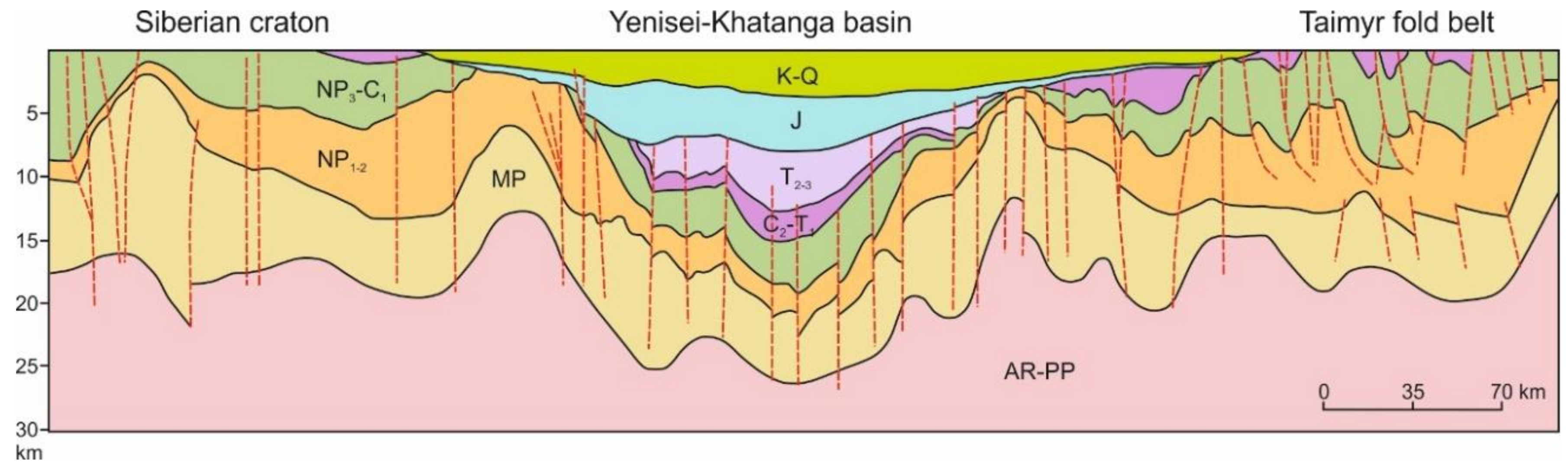
3. Structure and Development History of the Yenisei-Khatanga Basin

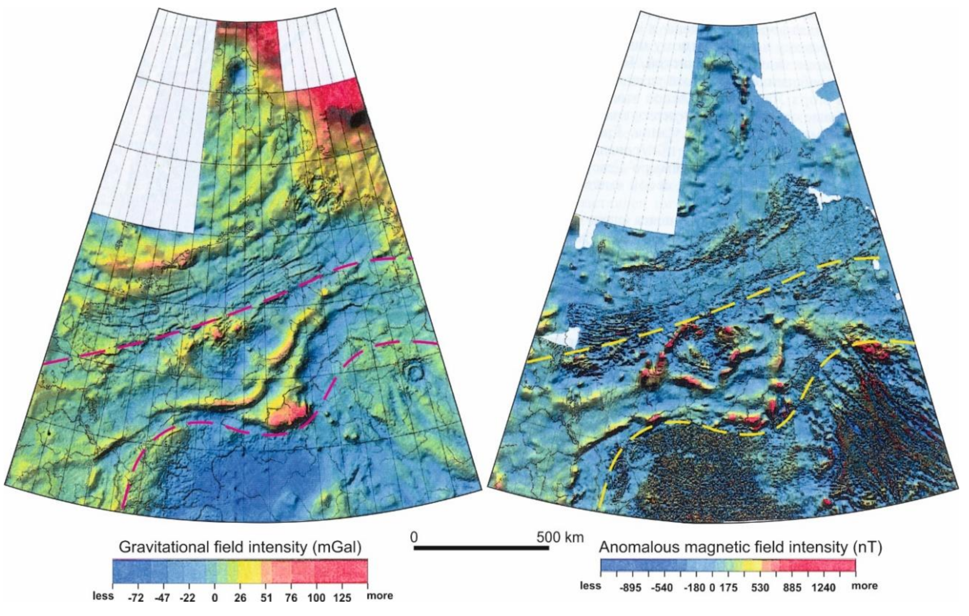
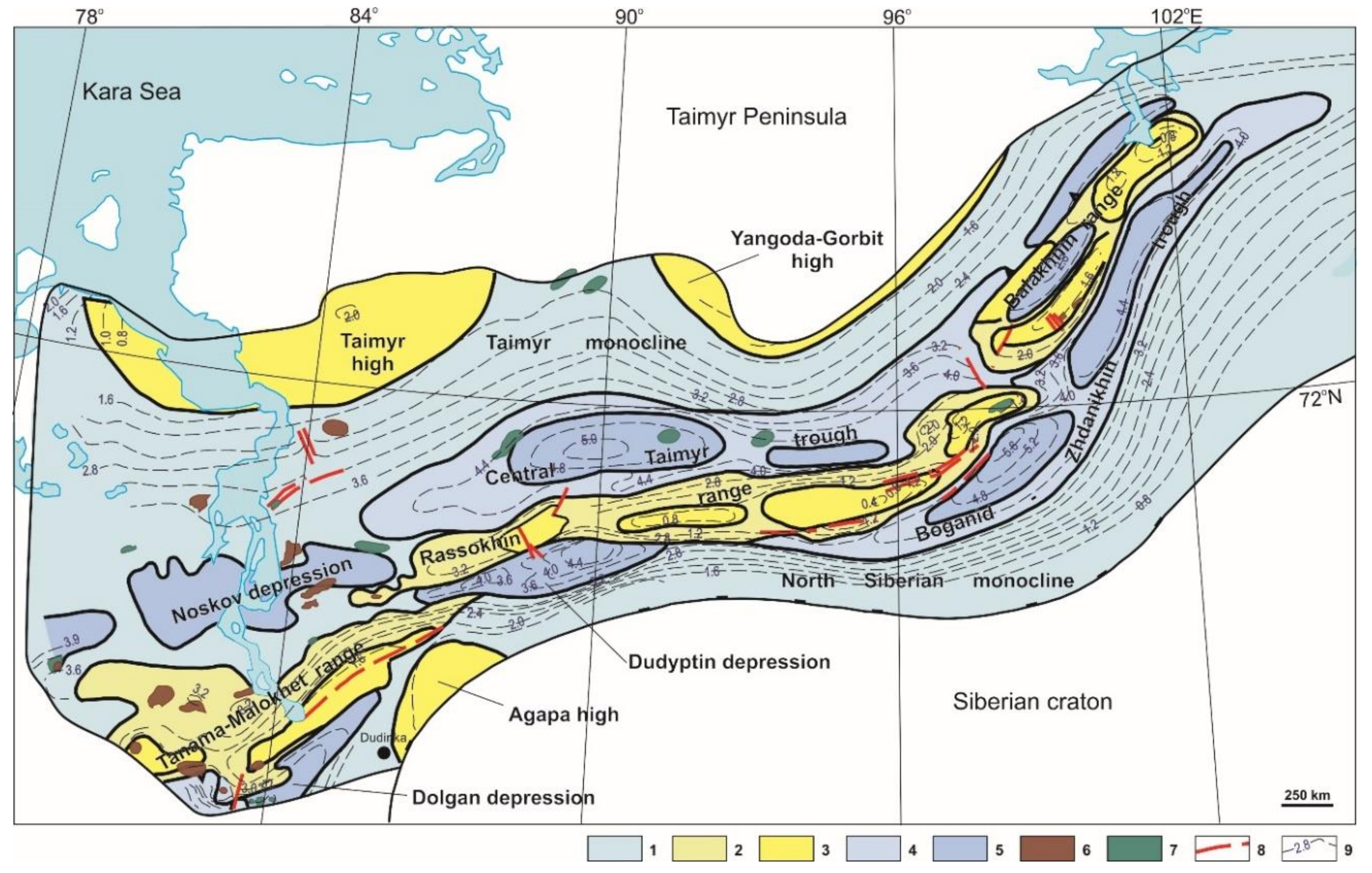
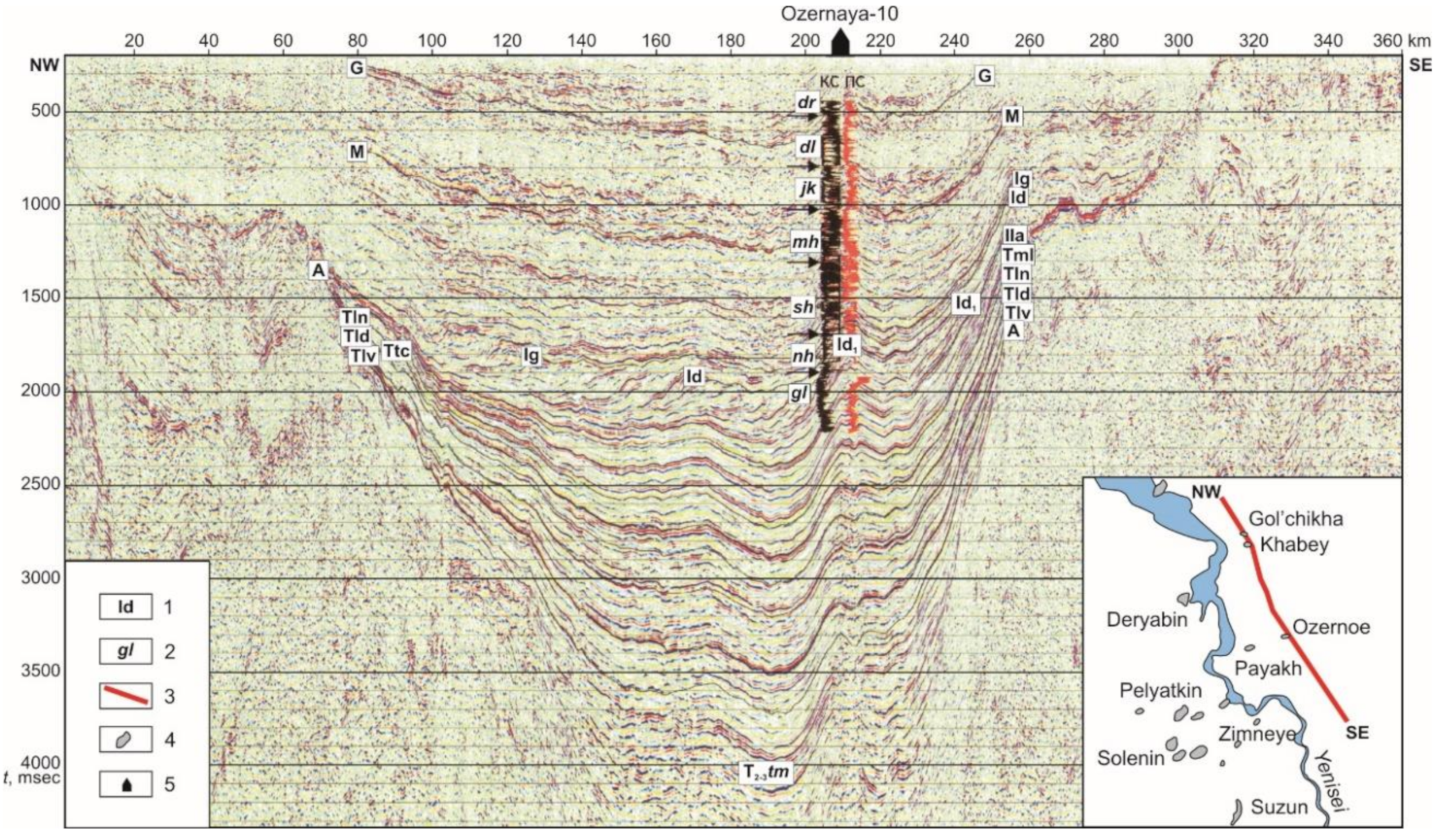
3.1. Main Structural Elements

The views on the inner structure of the Yenisei-Khatanga basin are mainly based on seismic data, supported by well data, most of which were obtained in the ranges of the axial area of the basin. On Figure 9 and Figure 10 are structural maps, on which isohypses show the base of the Jurassic deposits, the top of the Middle Jurassic, as well as swells and depressions of various scale.
In the flanks of the basin its monoclinal sedimentary section dips sharply towards the axial part (Figure 10). The northern flank (the Taimyr monocline) is less steep (2°–6°). This structure is complicated by the Taimyr and Yangoda-Gorbit basement highs. The southern flank (the North Siberian monocline) is narrow and steep (up to 8°–15°) in the north–west and widens and flattens in the east. In its south–western part there is the small Agapa basement high. The width of the monoclines varies from 20 to 150 km. The reduced thicknesses of the Jurassic–Cretaceous deposits on the crest is only 2–3 km. The monoclines are connected to the central zone of the basin by a system of faults, which provide a stepwise subsidence of the basement surface towards the axial part of the basin [19,20,21,53].
In the central zone of the basin there is a combination of large contrasting positive and negative structures. The first noticeable one is the chain of three echelon-like basement ranges (Tanama-Malokhet, Rassokhin, Balakhnin) (Figure 2 and Figure 10). They cross the basin diagonally from the southern flank in the west to the northern one in the east. The Tanama-Malokhet range is 300 km long and 60–140 km wide, the Rassokhin range is 570 × 45–60 km and the Balakhnin range is 260 × 40–60 km.
To the north and south of the chain of basement ranges the most subsided areas of the Yenisei-Khatanga basin are located. In the southern subsided part, several en-echelon depressions are located: Dolgan and Dudyptin depressions, the Boganid-Zhdanikhin trough, in the northern part—the Noskov depression and the Central Taimyr trough (Figure 10). The greatest depths of the base of Jurassic are observed in the Boganid-Zhdanikhin (8.5–10 km) and the Central Taimyr (7–7.5 km) trough.
Abrupt differences in depths (up to 5.5 km for the base of the Jurassic deposits) of the structural surfaces from the most depressed parts of the Yenisei-Khatanga basin to the roofs of the ranges undoubtedly indicate that the positive and negative structures are bordered by faults. The Tanama-Malokhet, Rassokhin and Balakhnin ranges form a system of large linear anticlines along the northern flank of the Malokhet-Rassokhin-Balakhnin fault [71]. In several cases, geophysical data indicate the thrusting of the ranges from north to south [72]. The fault is clearly reflected on the map of the gravitational field (Figure 8) by an intense positive anomaly (up to 70 mG) 10–50 km wide that can be traced for over 1500 km [69]. Deep seismic sounding indicates a tectonic step in the Moho discontinuity in the fault zone, reaching 4–7 km depending on estimates [24].
The consistent subsidence of the Yenisei-Khatanga basin during the Triassic and the Jurassic changed to an abrupt structural transformation at the Jurassic–Cretaceous boundary [17]. During this time there was an intensive growth of the Malokhet-Messoyakh range that had been developing in the Triassic–Jurassic, the Rassokhin range, that was formed in the Middle–Late Jurassic, and the newly formed Balakhnin range. Due to the intense growth of the range chain, the adjacent troughs structures also developed. Due to the intense uplift along the roofs of the ranges, some of the deposits were eroded. In this area, different levels of the Upper Jurassic–Valanginian deposits were eroded, and on some fields, the washing out also affected the Middle Jurassic deposits. The Upper Jurassic and Lower Cretaceous deposits were accumulated with reduced thicknesses [21,71,74].
To determine the reasons for the tectonic forces and the formation of the inverted structure of the basin in the Late Jurassic–Early Cretaceous, one must consider the tectonic events that took place at the same time on the adjacent territories. Regarding time, this transformation can be correlated with the late Cimmerian deformations in the Verkhoyansk fold-and-thrust belt. It is precisely in the Late Jurassic that the Kolyma-Omolon microcontinent collided with the margin of the Siberian craton [3]. This compressional deformation from the south–east affected the Yenisei-Khatanga basin, especially its eastern part, where they led to a partial inversion and the formation of a system of elongated ranges [6]. The intense compression from the east also manifested in deformations of the Jurassic deposits of Cape Tsvetkov on the Taimyr Peninsula, which in recent years has been progressively considered a result of the late Cimmerian Verkhoyansk folding [69,75].
Thus, the combination of large rift-related extension in the north–east of the region with compression strain in the south–east led to the transformation of the Yenisei-Khatanga basin’s structure in the Late Jurassic–Early Cretaceous time. Beginning with the Late Cretaceous, due to the levelling of the Taimyr Mountains, various uplifts on the Siberian craton became the main sources of material for the Yenisei-Khatanga basin. In the Paleogene–Neogene there was a general uplift of the Siberian craton, Taimyr, the Kara plate, and the Yenisei-Khatanga basin [6]. An erosion region formed here, from which material was transported in the sedimentation basins of the Kara and Laptev seas. During this time, weak inversion motions took place in the axial zone of the Yenisei-Khatanga basin (the Rassokhin and Balakhnin ranges), as well as active growth of salt domes near Khatanga bay [53]. All these tectonic processes on the shelf and the continental margin reflected the largest event of this stage—the opening of the Eurasian basin and the appearance of the Arctic mid-oceanic ridge–Gakkel Ridge.

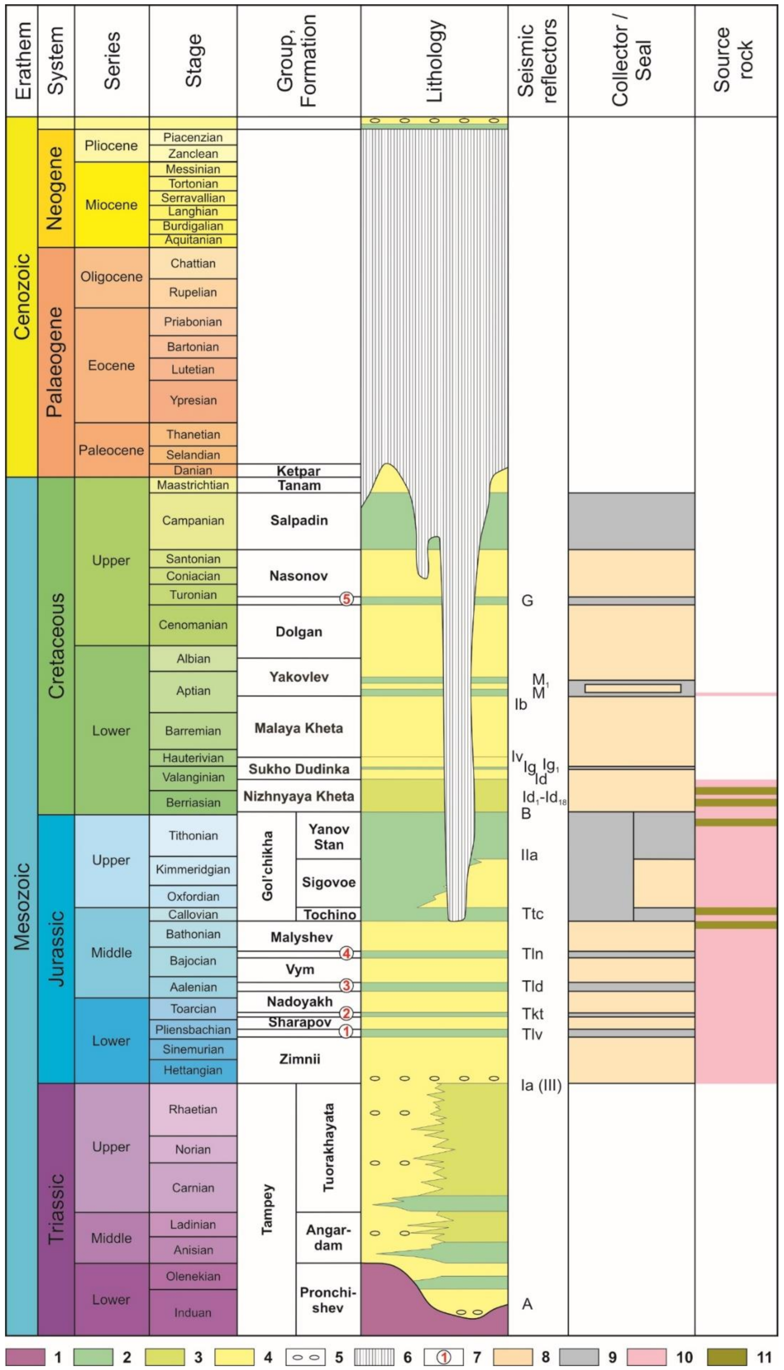
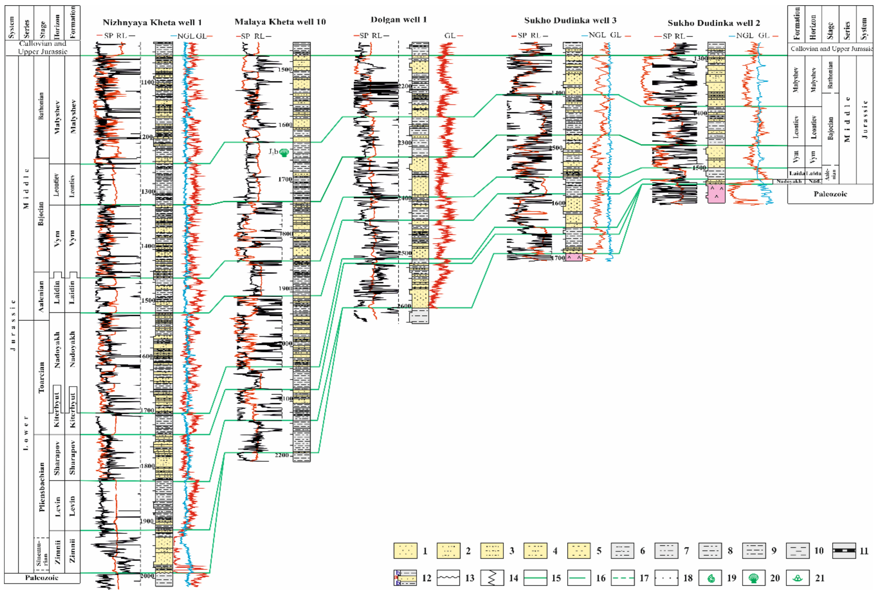
3.2. Sedimentary Infill of the Basin and Sedimentation History

The base of the sedimentary infill of the Yenisei-Khatanga basin is formed by Triassic deposits (Figure 11). In the western part of the basin the terrigenous Middle–Late Triassic Tampey Group (Series) is determined [76]. Its sections have been penetrated on the Zimnii, Gol’chikha, Vladimir, and Nizhnyaya Kheta fields, and some others (Figure 4). The base of the Tampey Group is associated with the “A” reflector (Figure 11 and Figure 12), and the top of the Group—with the “Ia (III)” reflector [77,78,79]. The Lower–Middle Triassic lagoonal, deltaic, shore-, shallow-, and deep-marine conglomerates, sandstones, siltstones and mudstones of the Pronchishev, Angardam, and Tuorakhayata groups are concentrated in the eastern part of the basin [80]. The thickest Triassic deposits are predicted in the eastern part of the basin. Here, on the Vladimir field, a 1380 m section of Triassic deposits has been penetrated [81].
Jurassic deposits within the Yenisei-Khatanga basin have a complete stratigraphic succession and occur everywhere. Their thickness decreases, and the lower horizons wedge out in the flank areas of the basin, as well as in individual large uplifts of its inner part.
The Lower–Middle Jurassic deposits are divided into nine formations (Figure 11 and Figure 13). Their cyclic alternation reflects eustatic variations of the sea level in the sedimentation basin [82]. Those formations that accumulated during marine transgressions (Levin, Kiterbyut, Laidin, and Leontiev formations) are composed mainly of mudstones, sometimes bituminous mudstones with marine fauna. They form clearly traceable reflectors on seismic profiles: The “T” group (“Tlv”, “Tkt”, “Tld”, “Tln”) (Figure 11 and Figure 12). The formations composed mainly of sandstones and mudstones (Zimnii, Sharapov, Nadoyakh, Vym, and Malyshev formations) accumulated in shallow-marine settings in stages of regression. Close to the paleo-coasts, their composition includes interbeds and lenses of coals and pebble conglomerates. The thickness of the Lower–Middle Jurassic deposits can reach 4500 m [81].
In Callovian–Lower Berriasian times, the transgression reached its peak. During this stage, mudstones, bituminous mudstones with siltstones and sandstones interlayers of the Gol’chikha Formation with a thickness of up to 950 m were accumulating in the basin (Figure 11). In the south–west of the basin the Upper Jurassic deposits reach 1000 m in thickness and have a three-part structure. The middle part is taken by the sandstones and siltstones of the Sigovoe Formation (Oxfordian–Kimmeridgian), which are overlapped by the Tochino Formation (Callovian) mudstones and themselves overlay the Yanov Stan Formation (Upper Kimmeridgian–Lower Berriasian) mudstones [82]. The top of the Yanov Stan formation corresponds to the “IIa” reflector (Figure 11 and Figure 12), the top of the Gol’chikha Formation–to the “B” reflector, the Tochino Formation–to the “Ttc” reflector [81,83]. In some individual large uplifts in the Yenisei-Khatanga basin, the deposits of the upper and partially the Middle Jurassic are eroded.
Cretaceous deposits are also located in the entire area of the Yenisei-Khatanga basin. Seismic data indicate that their thickness exceeds 3000 m with maximum thicknesses observed in the western part of the basin and gradually decrease to the east.
On seismic sections in the western part of the Yenisei-Khatanga basin the Berriassian–Hauterivian deposits (Nizhnyaya Kheta, Sukho Dudinka formations and their stratigraphic analogues) have a clinoform structure (Figure 11 and Figure 12) [81,84]. The Nizhnyaya Kheta Formation (Berriassian–Lower Valanginian) is mainly composed of mudstones with beds of sandstones in the base and the top. Its thickness can reach 600–1360 m [74]. The top of the formation corresponds to the “Id” reflector. The Sukho Dudinka Formation (upper Valanginian–lower Hauterivian, thickness: 200–800 m) is composed of sandstones and mudstones with siltstones interbeds in the lower and upper part. The middle of the formation is dominated by mudstones with sandstones interbeds. Its lower part corresponds to the “Ig” reflector, its top is correlated with the “Iv” reflector [84]. The clinoform complex itself is framed on the seismic sections by reflectors “IIa” in the top of the Yanov Stan Formation and “Ig1” within the Sukho Dudinka Formation. Its inner structure is underlined by reflectors “Ig”, “Id”, and “Id1–18”. The occurrence area of the clinoform complex exceeds 74,000 km2. In total, 18 clinoforms can be identified on the CDPM sections. The clinoforms dip to the north–west and become younger in the same direction (Figure 12). Reflectors are generated by mudstone layers that formed during brief transgressions. The spatial distribution of the clinoforms reflects the asymmetry of the sedimentary basin, whose northern part was more intensely subsided. The main input of terrigenous material in this sedimentation basin was from the south and the south–east from the uplifted dry land of the Siberian craton. Discharge of material from the Taimyr-Severnaya Zemlya orogen was significantly less, and along its margin one poorly defined clinoform is developed, directed in the opposite direction. On the left bank of the Yenisei River, the thickness of individual clinoforms exceeds 450 m. Their slope angles can vary from 1–2 to 4–6 degrees. Along paleo-slopes, gravity flows transported clastic material into the deep-water part of the basin forming deep-water turbidite fans and mass-transport derived sediment bodies. Towards the east–north–east the amount of clinoforms decreases, they become less steep, and the reflector pattern becomes more chaotic. To the east of the 90 degrees meridian, the clinoforms disappear from the seismic sections. Sedimentation took place here in conditions of more active input of terrigenous material into the sedimentary basin, which is reflected in increasing thicknesses of the Berriassian–Hauterivian deposits and in their increasing lithological homogeneity [84].
The Lower Cretaceous section is overlain by the Malaya Kheta Formation (Upper Hauterivian–Lower Aptian, thickness: 100–500 m) composed of sandstones with rare interbeds of siltstones, mudstones, conglomerates and coals [74]. The deposits formed in alluvial plain, near-shore, and coastal flood plain environments. The upper part of the formation corresponds to the “Ib” reflector (Figure 11 and Figure 12). It is conformably overlain by the Yakovlev Formation (thickness: 150–580 m) composed of mudstones and siltstones with interbeds of sandstones and coals. The age of the formation is between the Middle Aptian and the Middle Albian. The coal-mudstones layers of the lower part of the formation are correlated with the “M” and “M1” reflectors. From the end of the Albian to the Cenomanian the sandstones, siltstones, and mudstones of the Dolgan Formation (thickness: 160–780 m) accumulated in shallow-nearshore and lagoonal-continental environment. The Early Turonian marine transgression was the time of accumulation of the Dorozhkovo Formation (thickness: 40–130 m) mudstones with siltstones and sometime sandstones interbeds. The top of the mudstones corresponds to the “G” reflector (Figure 11 and Figure 12).
During the Middle Turonian–Maastrichtian the Yenisei-Khatanga basin continued to experience a steady, compensated subsidence. The sedimentation environment alternated between shallow-marine, shore-marine and continental environments. In the Middle Turonian–Santonian, the Nasonov Formation (thickness: 300–600 m) accumulated. It is composed of rhythmically alternating mudstones, siltstones, and sandstones layers with phosphorite horizons at the base of the layers. The Nasonov Formation is overlain by the Salpadin Formation (Campanian, 170 m thick), which is composed mainly of clays, opoka-like clays, argillaceous siltstones with rare interbeds of fine-grained sands that accumulated in shallow-marine conditions. The base of the formation is marked by a phosphorite horizon. The lower part of the formation has iron ore peas and oolites. The Cretaceous section ends with the Tanam Formation (Maastrichtian, up to 140 m thick) composed of sands and silts with interbeds of silty clays and a phosphorite horizon at the base [74].
The Upper Turonian–Maastrichtian deposits, as well as the Paleogene–Neogene formation are eroded for a significant part of the basin [74]. Only the Ketpar Formation was preserved (Danian, thickness up to 300 m), composed of sands and silts with clay interbeds. In the lower part of the formation there are gravels with clasts of bauxites.
In the Pleistocene the territory of the Yenisei-Khatanga basin was periodically occupied by marine transgressions. Regressions were accompanied by increased glacial activity. As a result, a cover of Quaternary deposits formed with thicknesses of 250–300 m. They are composed of marine clays and sands, moraine diamictons, fluvio-glacial and alluvial sands and pebblestones, lacustrine-glacier sands, silts and clays, subaerial clay loams. They overlie the washed-out surface of the Cretaceous, sometimes Jurassic and Paleogenic deposits.

4. Petroleum Geology

4.1. Discovered Hydrocarbon Fields

In the Yenisei-Khatanga basin 21 gas, gas condensate and oil fields have been discovered (Figure 4). The most oil perspective is the western part of the basin that is intensively studied by seismic surveys and drilling. Nearly all known fields are concentrated here. In the eastern part, only the Balakhnin and Novoye fields are located.
They are mainly multiplay fields (Figure 14). The depth of productive reservoirs varies from 750 to 3550 m. Mainly, the reservoirs belong to the Lower Cretaceous plays. Along with roof pools; there can often be lithologically and tectonically screened reservoirs.
The preservation of hydrocarbons accumulations in the plays was affected by widespread tectonic motions in the Yenisei-Khatanga basin in the Late Jurassic–Early Cretaceous and at the neotectonic stage. Tectonic motions favored the growth of swells and a general uplift of the territory, which caused the erosion of deposits, the local destruction of the seals, and the development of faults. This led to the migration of hydrocarbons to the upper stratigraphic levels, a significant seepage into the atmosphere and a decrease of the total quantity of hydrocarbon resources [17]. A favorable factor for the preservation of the hydrocarbons became the formation of the 700 m thick permafrost zone at the latest stage, which constitutes an additional seal. The second consequence of the appearance of the permafrost rocks was the formation of gas-hydrate accumulations.

4.2. Estimated Hydrocarbon Resources

The estimated mean volumes of undiscovered resources for the Yenisei-Khatanga Basin Province are approximately 25 billion boe: 5.6 billion barrels of crude oil, 100 trillion cubic feet of natural gas, and 2.7 billion barrels of natural gas liquids [85,86]. The total initial resources of hydrocarbons in the Jurassic–Cretaceous infill of the Yenisei-Khatanga basin for early 2009 were estimated [87] as 84.6 billion boe: gas—88%, oil—7%, condensate—5%. The Lower Cretaceous clinoform deposits can contain: Gas—134 trillion cubic feet, oil—12 billion boe (2.4 billion boe recoverable), condensate—2.7 billion boe (1.35 billion boe recoverable) [81]. Hydrocarbon resources in the basement of the basin and the Triassic deposits have not yet been estimated.

4.3. Hydrocarbon Systems and Plays

4.3.1. Source Rocks

Geochemical data only allow us to say that the hydrocarbons that formed in the basement of the basin did not migrate into the Mesozoic–Cenozoic sedimentary infill. Moreover, the oil and gas potential of the pre-middle Carboniferous complexes was already depleted by the time the Yenisei-Khatanga basin was formed [17].
The Triassic mudstones with thicknesses from tens to hundreds of meters could also have oil generation properties. According to various sources the organic carbon (Corg) concentrations here vary from 0.1–0.4 to 2–3% [74,80]. These marine sediments contain significant amounts of Type-II Organic Matter (OM).
The main oil and gas generating deposits of the Yenisei-Khatanga basin are the mudstones of the Jurassic and the Lower Cretaceous (Figure 11). Among them, there are no identified deposits distinguished by elevated contents of OM. The rocks contain OM of mixed type (Type-III and Type-II). The OM accumulated both in diffuse and concentrated (coals) form [17,88]. In general, the Jurassic–Cretaceous deposits section is weakly differentiated in terms of Corg content. The Middle Jurassic–Barremian mudstones have Corg concentrations of 0.34–1.6% [17,74], and in some cases 3% [88]. The Jurassic–Lower Cretaceous deposits are usually considered as gas generating [17]. However, some levels in the Yanov Stan, Gol’chikha, Malyshevka, and Nizhnyaya Kheta formations could have been oil generating [88]. Gases actively migrated from the deep parts of the basin in the upper horizons, and the oils accumulated mostly in the generating complex.

4.3.2. Plays and Seals

The Triassic complex. The oil and gas potential of the Triassic deposits of the Yenisei-Khatanga basin is scarcely studied. The structure of the Triassic section in the central and eastern parts of the basin allow a tentative identification of three to four sandy-silty plays with thicknesses of up to 300 m (Figure 11), overlapped by seals composed of marine mudstones with thicknesses ranging from 30 to 250 m. The porosity of the sandstones varies from 2% to 28%, the permeability from 0 to 138 mD [80]. Borehole sampling of the sandy layers of the Tampey Group yielded reservoir water with a flow rate of 38.4 m3/day [81]. Possible perspectives of the Triassic complex are indicated by oil and gas seepage within the Anabar-Khatanga saddle [89].
The Jurassic complex. The Jurassic deposits of the Yenisei-Khatanga basin show an alternating pattern of mainly sandy-silty and mudstone formations forming plays and seals. Reservoir rocks have been identified in the Zimnii, Sharapov, Nadoyakh, Vym, Malyshev and Sigovoye formations (Figure 14, Table 1). Mudstones of the Levin, Kiterbyut, Laidin, Leontiev, Gol’chikha, Tochino, and Yanov Stan formations are seals (Figure 11, Table 1). The plays are wedging-out near the margins of the basin, and in the upper parts of the ranges, and are mudded-off in the eastern part of the basin. Mudstones of the Levin (thickness 50–600 m), Kiterbyut (20–60 m), Laidin (20–160 m), Leontiev (45–475 m), Gol’chikha (140–1000 m), Tochino (25–200 m) and Yanov Stan (50–400 m) formations are seals (Figure 14).
The Cretaceous complex. The Cretaceous deposits are the main oil and gas bearing complex of the Yenisei-Khatanga basin. Just the Lower Cretaceous deposits include up to 90% of the known reserves of hydrocarbons. In the Cretaceous section, the Nizhnyaya Kheta, Sukho Dudinka, Malaya Kheta, lower Yakovlev, upper Yakovlev-Dolgan, and Nasonov plays are defined (Figure 11, Table 1). These are mostly stacked reservoirs with gas, gas condensate and condensate with rims [17,74,81,84,87]. The seals are represented by mudstones of the Dorozhkovo (40–130 m), Yakovlev (two layers with a thickness of tens of meters), and Salpadin (60–170 m) formations. In the Berriasian–Hauterivian section the regional and zonal seals are formed by argillaceous layers with thicknesses of the first tens of meters that accumulated in periods of regional transgressions and high sea levels. Among them the most widespread is the Pelyatin layer with a thickness of 50–140 m. Additional sealing of the sandy strata in the Nizhnyaya Kheta-Sukho Dudinka play is provided by argillaceous layers formed in distal and slope parts of clinoforms [17,74,81,84].

5. Conclusions

Studies of the structure and tectonic evolution of the north–western margin of the Siberian craton and the arctic structures adjacent to the Kara Sea and the West-Siberian plate indicate that the basement of the Yenisei-Khatanga basin, the basin itself and the rift that generated it were all formed within the Siberian craton. This review presents our opinion on the geodynamic evolution of the north–western (Arctic) margin of the Siberian craton from the Precambrian–Paleozoic and Mesozoic folded structures that formed due to accretion and collisional processes to the formation of the rift-related late Paleozoic–Cenozoic Yenisei-Khatanga sedimentary basin. Geological, geophysical, paleomagnetic and petro-geochemical data obtained in recent years conclusively confirm the sequence of tectonic events previously proposed [5,44]. Moreover, new paleomagnetic data allowed us to create more accurate paleogeodynamic reconstructions for the Siberian craton, the Kara microcontinent and their interactions in the Paleozoic and Mesozoic [25,27,28]. We were also able to show that the predecessor of the Yenisei-Khatanga was a wide late Paleozoic basin that occupied the space between Southern Taimyr and the Siberian craton and deepened towards Taimyr. The formation of the Yenisei-Khatanga basin itself, like the formation of the West-Siberian basin, is related to continental rifting at the Permian–Triassic boundary. The formation of inversion structures in the basin in the Late Jurassic–Early Cretaceous [75] remain debatable. The time of this inversion can be correlated with late Cimmerian deformations in the Verkhoyansk fold belt [3]. This compression deformation affected the Jurassic deposits on Cape Tsvetkov on the Taimyr Peninsula [69,75], as well as the Yenisei-Khatanga basin, especially in its eastern part, where it led to partial inversion and the formation of a system of elongated ranges [6,72].
The Yenisei-Khatanga petroleum bearing area is a part of the West-Siberian petroleum province. The sedimentary cover is also represented by mostly sandy-silty Mesozoic deposits. The main oil and gas potential of the region are related to the Lower Cretaceous clinoform complex and the Jurassic deposits. The Mesozoic deposits of the region contain a huge amount of dispersed organic matter and have favorable conditions for catagenic maturation, mostly for gas generation. The productive part of the section of the sedimentary infill is significantly mudded-off and characterized by significant areal changes in composition. Most of the area has seals with high sealing properties. Only in areas where they partially or completely wedge-out due to stratigraphic breaks their sealing properties become decreased or are low.

Author Contributions

Conceptualization, V.V., E.D., and N.M.; Methodology, G.S. and D.M.; Formal Analysis, G.S. and E.D.; Resources, G.S.; Data Curation, N.P.; Writing—Original Draft Preparation, V.V., E.D., G.S., D.M., and N.M.; Writing—Review & Editing, V.V., E.D., N.M.; Visualization, N.M. and E.D.; Supervision, V.V.; Funding Acquisition, V.V. and D.M.

Funding

This work was financially supported by grants from the RSF (project No. 14-37-00030), the RFBR (projects 16-05-00523, 18-05-70035), and the Integrated research program of the SB RAS (project No. II.1.28.1).

Acknowledgments

The authors express deep gratitude to the reviewers for their comprehensive and useful suggestions, which allowed us to significantly improve this paper.

Conflicts of Interest

The authors declare no conflict of interest. The funders had no role in the design of the study; in the collection, analyses, or interpretation of data; in the writing of the manuscript, and in the decision to publish the results.

References

  1. Pogrebitsky, Yu.E. Paleotectonic Analysis of the Taimyr Fold System; Nedra: Leningrad, Russia, 1971; 248p. (In Russian) [Google Scholar]
  2. Khain, V.E. Regional Geotectonics. Pre-Alpian Asia and Australia; Nedra: Moscow, Russia, 1979; 356p. (In Russian) [Google Scholar]
  3. Khain, V.E. Tectonics of Continents and Oceans (Year 2000); Scientific Word: Moscow, Russia, 2001; 606p. (In Russian) [Google Scholar]
  4. Zabiyaka, A.I.; Zabiyaka, I.D.; Vernikovsky, V.A.; Serdyuk, S.S.; Zlobin, M.M. Geological Structure and Tectonic Evolution of Northeastern Taimyr; Nauka: Novosibirsk, Russia, 1986; 144p. (In Russian) [Google Scholar]
  5. Vernikovsky, V.A. Geodynamic Evolution of Taimyr Folded Area; Publishing House SB RAS: Novosibirsk, Russia, 1996; 202p. (In Russian) [Google Scholar]
  6. Bogdanov, N.A.; Khain, V.E.; Rosen, O.M.; Shipilov, E.V.; Vernikovsky, V.A.; Drachev, S.L.; Kostyuchenko, S.H.; Kuzmichev, A.B.; Sekretov, S.B. Tectonic Map of the Kara and Laptev Seas and North Siberia (Scale 1:2,500,000); Explanatory Note; Institute of the Lithosphere of Marginal and Inner Seas RAS: Moscow, Russia, 1998; 127p. (In Russian) [Google Scholar]
  7. Zonenshain, L.P.; Kuzmin, M.I.; Natapov, L.M. Geology of the USSR: A Plate Tectonic Synthesis; Page, B.M., Ed.; Geodynamic Series, 21; American Geophysical Union: Washington, DC, USA, 1990; 242p. [Google Scholar]
  8. Pease, V.; Vernikovsky, V. The tectono-magmatic evolution of the taimyr peninsula: Further constraints from new ion-microprobe data. Polarforschung 2000, 68, 171–178. [Google Scholar]
  9. Walderhaug, H.J.; Eide, E.A.; Scott, R.A.; Inger, S.; Golionko, E.G. Palaeomagnetism and 40Ar/39Ar geochronology from the South Taimyr igneous complex, Arctic Russia: A Middle–Late Triassic magmatic pulse after Siberian flood-basalt volcanism. Geophys. J. Int. 2005, 163, 501–517. [Google Scholar] [CrossRef]
  10. Drachev, S.S.; Malyshev, N.A.; Nikishin, A.M. Tectonic history and petroleum geology of the Russian Arctic Shelves: An overview. In Petroleum Geology: From Mature Basins to New Frontiers—Proceedings of the 7th Petroleum Geology Conference; Vining, B.A., Pickering, S.C., Eds.; Geological Society: London, UK, 2010; pp. 591–619. [Google Scholar]
  11. Nikishin, V.A.; Malysgev, N.A.; Nikishin, A.M.; Obmetko, V.V. Late Permian–Triassic rift system of the South Kara sedimentary basin. Vestnik Moskovskogo Univ. Seriya 4. 2011, 6, 3–9. (In Russian) [Google Scholar] [CrossRef]
  12. Cherepanova, Y.; Artemieva, I.M.; Thybo, H.; Chemia, Z. Crustal structure of the Siberian craton and the West Siberian basin: An appraisal of existing seismic data. Tectonophysics 2013, 609, 154–183. [Google Scholar] [CrossRef]
  13. Zhang, X.; Omma, J.; Pease, V.; Scott, R. Provenance of Late Paleozoic-Mesozoic Sandstones, Taimyr Peninsula, the Arctic. Geosciences 2013, 3, 502–527. [Google Scholar] [CrossRef]
  14. Klitzke, P.; Faleide, J.I.; Scheck-Wenderoth, M.; Sippel, J. A lithosphere-scale structural model of the Barents Sea and Kara Sea region. Solid Earth 2015, 6, 153–172. [Google Scholar] [CrossRef] [Green Version]
  15. Drachev, S.S. Fold belts and sedimentary basins of the Eurasian Arctic. Arktos 2016, 2, 21. [Google Scholar] [CrossRef]
  16. Gautier, D.L.; Bird, K.J.; Charpentier, R.R.; Grantz, A.; Houseknecht, D.W.; Klett, T.R.; Moore, T.E.; Pitman, J.K.; Schenk, C.J.; Schuenemeyer, J.H.; et al. Oil and gas resourse potential north of the Arctic Circle. Geol. Soc. Lond. Mem. 2011, 35, 131–144. [Google Scholar] [CrossRef]
  17. Kontorovich, A.E.; Grebenyuk, V.V.; Kuznetsov, L.L.; Kulikov, D.P.; Khmelevsky, V.B.; Azarnov, A.N.; Nakaryakov, V.D.; Polyakova, I.D.; Sibgatullin, V.G.; Soboleva, E.I.; et al. The Yenisey-Khatanga Basin; UIGGM SB RAS: Novosibirsk, Russia, 1994; 71p. (In Russian) [Google Scholar]
  18. Bochkarev, V.S.; Braduchan, Yu.V.; Voronin, A.S.; Generalov, P.P.; Kovrigina, E.K.; Kulakhmetov, N.Kh.; Mitusheva, V.S.; Stavitsky, B.P.; Faybusovich, Ya.E.; Shemraeva, S.V. State Geological Map of the Russian Federation. Scale 1:1,000,000 (New Series). Sheet R-43-(45)—Gydan-Dudinka. Explanatory Note; VSEGEI: St. Petersburg, Russia, 2000; 187p. (In Russian)
  19. Kovrigina, E.K. State Geological Map of the Russian Federation. Scale 1:1,000,000 (New Series). Sheet R-(45)-47—Norilsk. Explanatory Note; VSEGEI: St. Petersburg, Russia, 2000; 479p. (In Russian) [Google Scholar]
  20. Pogrebitsky, Yu.E.; Lopatin, B.G. State Geological Map of the Russian Federation. Scale 1:1,000,000 (New Series). Sheet S-44-46—Ust-Tareya; Explanatory Note; VSEGEI: St. Petersburg, Russia, 2000; 251p. (In Russian) [Google Scholar]
  21. Talvirsky, D.B. Tectonics of the Yenisei-Khatanga Oil and Gas Bearing Region and Adjacent Territories from Geophysical Data; Nedra: Moscow, Russia, 1976; 168p. (In Russian) [Google Scholar]
  22. Kazais, V.I. Innovation decision of regional structure task in difficult areas of Arctic (Taimyr sector). Oil Gas Geol. 2012, 1, 74–91. (In Russian) [Google Scholar]
  23. Egorkin, A.V.; Kostiuchenko, S.L. Inhomogeneity of the upper mantle structure of Siberia. In 1993 CCSS Workshop Proceedings Volume; Mooney, W.D., Ed.; United States Geological Survey: Menlo Park, CA, USA, 1995; pp. 122–132. [Google Scholar]
  24. Dolmatova, I.V.; Peshkova, I.N. Model of a rift destruction of the northern palaeomargin of the Siberian continent (Yenisei-Khatanga basin). Geol. Geofizika Razrabotka Neftyanykh Mestorozhdeniy 2001, 7, 30–33. (In Russian) [Google Scholar]
  25. Metelkin, D.V.; Vernikovsky, V.A.; Kazansky, A.Yu. Tectonic evolution of the Siberian paleocontinent from the Neoproterozoic to the Late Mesozoic: Paleomagnetic record and reconstructions. Russ. Geol. Geophys. 2012, 53, 675–688. [Google Scholar] [CrossRef]
  26. Metelkin, D.V.; Kazansky, A.Yu.; Vernikovsky, V.A.; Gee, D.; Torsvik, T. First paleomagnetic data on the Early Paleozoic rocks from the Severnaya Zemlya archipelago and their geodynamic interpretation. Russ. Geol. Geophys. 2000, 41, 1767–1772. [Google Scholar]
  27. Metelkin, D.V.; Vernikovsky, V.A.; Kazansky, A.Yu.; Bogolepova, O.K.; Gubanov, A.P. Paleozoic history of the Kara microcontinent and its relation to Siberia and Baltica: Paleomagnetism, paleogeography and tectonics. Tectonophysics 2005, 398, 225–243. [Google Scholar] [CrossRef]
  28. Metelkin, D.V.; Vernikovsky, V.A.; Matushkin, N.Yu. Arctida between Rodinia and Pangea. Prec. Res. 2015, 259, 114–129. [Google Scholar] [CrossRef]
  29. Vernikovsky, V.A.; Dobretsov, N.L.; Metelkin, D.V.; Matushkin, N.Yu.; Koulakov, I.Yu. Concerning tectonics and the tectonic evolution of the Arctic. Russ. Geol. Geophys. 2013, 54, 838–858. [Google Scholar] [CrossRef]
  30. Golonka, J.; Krobicki, M.; Pajak, J.; Van Giang, N.; Zuchiewicz, W. Global PlateTectonics and Paleogeography of Southeast Asia; AGN University of Science and Technology: Krakov, Poland, 2006; 128p. [Google Scholar]
  31. Cocks, L.R.M.; Torsvik, T.H. Siberia, the wandering northern terrane, and its changing geography through the Paleozoic. Earth Sci. Rev. 2007, 82, 29–74. [Google Scholar] [CrossRef]
  32. Lawver, L.A.; Ganagan, L.M.; Norton, I. Paleogeographic and tectonic evolution of the Arctic region during the Paleozoic. In Arctic Petroleum Geology; Spencer, A.M., Embry, A.F., Gautier, D.L., Stoupakova, A.V., Sørensen, K., Eds.; The Geological Society: London, UK, 2011; Volume 35, pp. 61–77. [Google Scholar]
  33. Torsvik, T.H.; Cocks, L.R.M. Earth History and Palaeogeography; Cambridge University Press: Cambridge, UK, 2017; 317p. [Google Scholar]
  34. Pisarevsky, S.A.; Natapov, L.M. Siberia and Rodinia. Tectonophysics 2003, 375, 221–245. [Google Scholar] [CrossRef]
  35. Vernikovsky, V.A.; Vernikovskaya, A.E.; Pease, V.L.; Gee, D.G. Neoproterozoic orogeny along the margins of Siberia. Geol. Soc. Lond. Mem. 2004, 30, 233–247. [Google Scholar] [CrossRef]
  36. Vernikovsky, V.A.; Metelkin, D.V.; Vernikovskaya, A.E.; Matushkin, N.Yu.; Kazansky, A.Yu.; Kadilnikov, P.I.; Romanova, I.V.; Wingate, M.T.D.; Larionov, A.N.; Rodionov, N.V. Neoproterozoic tectonic structure of the Yenisei Ridge and formation of the western margin of the Siberian craton based on new geological, paleomagnetic, and geochronological data. Russ. Geol. Geophys. 2016, 57, 47–68. [Google Scholar] [CrossRef]
  37. Semikhatov, M.A.; Ovchinnikova, G.V.; Gorokhov, I.M.; Kuznetsov, A.B.; Vasil’eva, I.M.; Gorokhovsky, B.M.; Podkovyrov, V.V. Isotopic age of Middle-Upper Riphean boundary: Pb-Pb geochronology of Lakhanda Group carbonates, Eastern Siberia. Dokl. Earth Sci. 2000, 372, 216–221. [Google Scholar]
  38. Petrov, P.Y.; Semikhatov, M.A. Sequence organization and growth patterns of late Mesoproterozoic stromatolite reefs: An example from the Burovaya Formation, Turukhansk Uplift, Siberia. Prec. Res. 2001, 111, 257–281. [Google Scholar] [CrossRef]
  39. Frolov, S.V.; Akhmanov, G.G.; Bakay, E.A.; Lubnina, N.V.; Korobova, N.I.; Karnyushina, E.E.; Kozlova, E.V. Meso-Neoproterozoic petroleum systems of the Eastern Siberian sedimentary basins. Prec. Res. 2014, 259, 95–113. [Google Scholar] [CrossRef]
  40. Khain, V.E.; Gusev, G.S.; Khain, E.V.; Vernikovsky, V.A.; Volobuyev, M.I. Circum-Siberian Neoproterozoic Ophiolite Belt. Ofioliti 1997, 22, 195–200. [Google Scholar]
  41. Vernikovsky, V.A.; Sal’nikova, E.B.; Kotov, A.B.; Ponomarchuk, V.A.; Kovach, V.P.; Travin, A.V. Age of post-collisional granitoids, North Taimyr: U-Pb, Sm-Nd, Rb-Sr and Ar-Ar data. Doklady RAN 1998, 363, 375–378. (In Russian) [Google Scholar]
  42. Vernikovsky, V.A.; Vernikovskaya, A.E.; Sal’nikova, E.B.; Berezhnaya, N.G.; Larionov, A.N.; Kotov, A.B.; Kovach, V.P.; Vernikovskaya, I.V.; Matushkin, N.Yu.; Yasenev, A.M. Late Riphean alkaline magmatism in the western margin of the Siberian Craton: A result of continental rifting or accretionary events? Dokl. Earth Sci. 2008, 419, 226–230. [Google Scholar] [CrossRef]
  43. Proskurnin, V.F.; Vernikovsky, V.A.; Metelkin, D.V.; Petrushkov, B.S.; Vernikovskaya, A.E.; Gavrish, A.V.; Bagaeva, A.A.; Matushkin, N.Yu.; Vinogradova, N.P.; Larionov, A.N. Rhyolite–granite association in the Central Taimyr zone: Evidence of accretionary-collisional events in the Neoproterozoic. Russ. Geol. Geoph. 2014, 55, 18–32. [Google Scholar] [CrossRef]
  44. Vernikovsky, V.A.; Vernikovskaya, A.E. Central Taimyr accretionary belt (Arctic Asia): Meso-Neoproterozoic tectonic evolution and Rodinia break up. Prec. Res. 2001, 110, 127–141. [Google Scholar] [CrossRef]
  45. Vernikovskii, V.A.; Kotov, A.B.; Ponomarchuk, V.A.; Sal’nikova, E.B.; Kovach, V.P.; Travin, A.V. Late Riphean-Vendian tectonic event responsible for the formation of North Taimyr (based on Sm-Nd, Rb-Sr, K-Ar isotopic dating of garnet amphibolites from the Stanovoy Ophiolitic Belt). Doklady Akad. Nauk 1997, 352, 218–221. [Google Scholar]
  46. Bezzubtsev, V.V.; Zalyalyaev, P.Sh.; Sakovich, A.B. Geological Map of Mountainous Taimyr, Scale 1:500,000; Explanatory Note; Krasnoyarskgeologiya: Krasnoyarsk, Russia, 1986; 177p. (In Russian) [Google Scholar]
  47. Lopatin, V.M.; Natapov, L.M.; Uflyand, A.K.; Ushakov, A.N.; Chernov, D.V. Geodynamic nature of the Riphean volcanic belt of Taimyr. In Paleovolcanism of the Altai-Sayan Folded Area and the Siberian Platform; Nauka: Novosibirsk, Russia, 1991; pp. 58–62. [Google Scholar]
  48. Nikishin, A.M.; Sobornov, K.O.; Prokopiev, A.V.; Frolov, S.V. Tectonic evolution of the Siberian Platform during the Vendian and Phanerozoic. Mosc. Univ. Geol. Bull. 2010, 65, 1–16. [Google Scholar] [CrossRef]
  49. Deviatov, V.P.; Savchenko, V.I. New data for hydrocarbon resources reevaluation of Anabar-Khatanga oil-and-gas bearing area. Oil Gas Geol. 2012, 1, 55–61. (In Russian) [Google Scholar]
  50. Vernikovsky, V.A. Metamorphic formations and geodynamics of the Northern Taimyr. Russ. Geol. Geophys. 1992, 33, 42–49. [Google Scholar]
  51. Vernikovsky, V.A.; Neimark, L.A.; Ponomarchuk, V.A.; Vernikovskaya, A.E. Geochemistry and age of collisional granitoides and metamorphites of the Kara microcontinent (Northern Taimyr). Russ. Geol. Geophys. 1995, 36, 46–60. [Google Scholar]
  52. Vernikovsky, V.A.; Kovach, V.P.; Kotov, A.B.; Vernikovskaya, A.E.; Sal’nikova, E.B. Sources of granitoids and the evolutionary stages of the continental crust in the Taimyr folded area. Geochem. Int. 1999, 37, 493–502. [Google Scholar]
  53. Pogrebitsky, Yu.E.; Shanurenko, N.K. State Geological Map of the Russian Federation. Scale 1:1,000,000. Sheet S-47-49—Lake Taimyr. Explanatory Note; VSEGEI: St. Petersburg, Russia, 1998; 231p. (In Russian) [Google Scholar]
  54. Metelkin, D.V. Evolution of the Structures of Central Asia and the Role of Strike-Slip Tectonics According to Paleomagnetic Data; IPGG SB RAS: Novosibirsk, Russia, 2012; 460p. (In Russian) [Google Scholar]
  55. Inger, S.; Scott, R.A.; Golionko, B.G. Tectonic evolution of the Taimyr Peninsula, northern Russia: Implications for Arctic continental assembly. J. Geol. Soc. 1999, 6, 1069–1072. [Google Scholar] [CrossRef]
  56. Dobretsov, N.L. Permian–Triassic magmatism and sedimentation in Eurasia as result of superplume. Doklady Akad. Nauk 1997, 354, 220–223. [Google Scholar]
  57. Dobretsov, N.L.; Vernikovsky, V.A. Mantle plumes and their geological manifestations. Int. Geol. Rev. 2001, 43, 771–787. [Google Scholar] [CrossRef]
  58. Renne, P.R.; Basu, A.R. Rapid eruption of the Siberian Traps flood basalts at the Permo–Triassic Boundary. Science 1991, 253, 176–179. [Google Scholar] [CrossRef] [PubMed]
  59. Campbell, I.H.; Czamanske, G.K.; Fedorenko, V.A.; Hill, R.I.; Stepanov, V. Synchronism of the Siberian Traps and the Permian–Triassic Boundary. Science 1992, 258, 1760–1763. [Google Scholar] [CrossRef] [PubMed]
  60. Deev, E.V.; Votakh, O.A.; Belyaev, S.Yu.; Zinov’ev, S.V.; Levchuk, M.A. Tectonic map of the basement of the Mid-Ob’ plate complex (West Siberia). Russ. Geol. Geophys. 2001, 42, 968–978. [Google Scholar]
  61. Saunders, A.D.; England, R.W.; Reichow, M.K.; White, R.V. A mantle plume origin for the Siberian Traps. Uplift and extension in the West Siberian Basin. Lithos 2005, 79, 407–424. [Google Scholar] [CrossRef]
  62. Dobretsov, N.L.; Kirdyashkin, A.A.; Kirdyashkin, A.G.; Vernikovsky, V.A.; Gladkov, I.N. Modelling of thermochemical plumes and implications for the origin of the Siberian Traps. Lithos 2008, 100, 66–92. [Google Scholar] [CrossRef]
  63. Dobretsov, N.L.; Vernikovsky, V.A.; Karyakin, Yu.V.; Korago, E.A.; Simonov, V.A. Mesozoic–Cenozoic volcanism and geodynamic events in the Central and Eastern Arctic. Russ. Geol. Geophys. 2013, 54, 874–887. [Google Scholar] [CrossRef]
  64. Reichow, M.K.; Saunders, A.D.; White, R.V.; Pringle, M.S.; Al’Mukhamedov, A.I.; Medvedev, A.Ya.; Kirda, N.P. 40Ar/39Ar dates from the West Siberian basin: Siberian flood basalt province doubled. Science 2002, 296, 1846–1849. [Google Scholar] [CrossRef] [PubMed]
  65. Vernikovsky, V.A.; Pease, V.; Vernikovskaya, A.E.; Romanov, A.P.; Gee, D.G.; Travin, A.V. First report of early Triassic A-type granite and syenite intrusions from Taimyr: Product of the northern Eurasian superplume? Lithos 2003, 66, 23–36. [Google Scholar] [CrossRef]
  66. Aplonov, S.V. An aborted Triassic ocean in West Siberia. Tectonics 1988, 7, 1103–1122. [Google Scholar] [CrossRef]
  67. Aplonov, S.V. The tectonic evolution of West Siberia: An attempt at a geophysical analysis. Tectonophysics 1995, 245, 61–84. [Google Scholar] [CrossRef]
  68. Metelkin, D.V.; Vernikovsky, V.A.; Kazansky, A.Yu.; Wingate, M.T.D. Late Mesozoic tectonics of Central Asia based on paleomagnetic evidence. Gondwana Res. 2010, 18, 400–419. [Google Scholar] [CrossRef]
  69. Proskurnin, V.F.; Simonov, O.N.; Sobolev, N.N.; Tuganova, E.V.; Uklein, V.N. Tectonic zoning of the north of Central Siberia (Taimyr AD). In Natural Resources of Taimyr; Ministry of Natural Resources: Dudinka, Russia, 2003; Volume 1, pp. 178–209. [Google Scholar]
  70. Staroseltsev, V.S. Lena-Yenisei cascade of Mesozoic depressions in the northern margin of the Siberian platform in connection with petroleum potential. Geol. Miner. Resour. Siberia 2013, 1, 46–53. (In Russian) [Google Scholar]
  71. Baldin, V.A.; Kunin, K.N.; Kunin, N.Ya. New considerations on the structure and origin of the diagonal megabank system in the Yenisei-Khatanga basin. Oil Gas Geol. 1997, 3, 26–34. (In Russian) [Google Scholar]
  72. Sobornov, K.; Afanasenkov, A.; Gogonenkov, G. Strike-Slip Faulting in the Northern Part of the West Siberian Basin and Enisey-Khatanga Trough: Structural Expression, Development and Implication for Petroleum Exploration. 2015. Available online: http://www.searchanddiscovery.com/pdfz/documents/2015/10784sobornov/ndx_sobornov.pdf.html (accessed on 31 October 2018).
  73. Structural-Tectonic Map of the Siberian Platform by, V.S. Staroseltsev. Available online: http://www.sniiggims.ru/maps/strtect.html (accessed on 5 October 2018).
  74. Glagolev, P.L.; Mazanov, V.F.; Mikhailova, M.P. Geology and Oil and Gas Potential of the Yenisei-Khatanga Basin; IGiRGI: Moscow, Russia, 1994; 118p. (In Russian) [Google Scholar]
  75. Khudoley, A.K.; Verzhbitsky, V.; Zastrozhnov, D.; O’Sullivan, P.B.; Ershovaa, V.; Proskurninc, V.F.; Tuchkova, M.I.; Rogovf, M.; Kyserg, T.K.; Malysheva, S.V.; et al. Late Paleozoic—Mesozoic tectonic evolution of the Eastern Taimyr-Severnaya Zemlya Fold and Thrust Belt and adjoining Yenisey-Khatanga Depression. J. Geodyn. 2018, 119, 221–241. [Google Scholar] [CrossRef]
  76. Bochkarev, V.S.; Brekhuntsov, A.M.; Deshchenya, N.P. The Paleozoic and Triassic evolution of West Siberia (data of comprehensive studies). Russ. Geol. Geophys. 2003, 44, 115–140. [Google Scholar]
  77. Deyev, E.V.; Zinoviev, S.V. Morphotectonics of the basement surface of the West-Siberian basin within Nadym-Tazovsk interfluves. Geotecton. Metall. 2003, 27, 11–23. [Google Scholar]
  78. Deev, E.V.; Zinoviev, S.V.; Chikov, B.M. Structural model of Pre-Cretaceous complexes of the West-Siberian basin (using the example of Nadym-Tazovsk interfluve). Lithosphere 2004, 2, 61–80. (In Russian) [Google Scholar]
  79. Kontorovich, V.A.; Ayunova, D.V.; Gubin, I.A.; Ershov, S.V.; Kalinin, A.Yu.; Kalinina, L.M.; Kanakov, M.S.; Solov’ev, M.V.; Surikova, E.S.; Shestakova, N.I. Seismic stratigraphy, formation history and gas potential of the Nadym-Pur interfluve area (West Siberia). Russ. Geol. Geophys. 2016, 57, 1248–1258. [Google Scholar] [CrossRef]
  80. Kazakov, A.M.; Konstantinov, A.G.; Kurushin, N.I.; Mogutcheva, N.K.; Sobolev, E.S.; Fradkina, A.F.; Yadryonkin, A.V.; Devyatov, V.P.; Smirnov, L.V. Stratigraphy of Oil and Gas Basins of Siberia. Triassic System; Publishing House SB RAS: Novosibirsk, Russia, 2002; 322p. (In Russian) [Google Scholar]
  81. Isayev, A.V.; Devyatov, V.P.; Karpukhin, S.M.; Krinin, V.A. Oil and gas prospects of the Yenisei-Khatanga regional trough. Oil Gas Geol. 2010, 4, 13–23. (In Russian). Available online: https://drive.google.com/file/d/0B_bCwpRhYduYdHAwdWRrT05fM1k/view (accessed on 3 October 2018).
  82. Shurygin, В.N.; Nikitenko, В.L.; Devyatov, V.P.; Ilyina, V.I.; Meledina, S.V.; Gaideburova, E.A.; Dzyuba, O.S.; Kazakov, A.M.; Mogucheva, N.K. Stratigraphy of Oil and Gas Basins of Siberia. Jurassic System; Publishing House SB RAS: Novosibirsk, Russia, 2000; 480p. (In Russian) [Google Scholar]
  83. Kontorovich, V.A. The tectonic framework and petroleum prospects of the western Yenisei-Khatanga regional trough. Russ. Geol. Geophys. 2011, 52, 804–824. [Google Scholar] [CrossRef]
  84. Isayev, A.V.; Krinin, V.A.; Filiptsov, Yu.A.; Karpukhin, S.M.; Sklyarov, V.R. Potential oil-and-gas bearing objects in the clinoform complexes of the Yenisey-Khatanga regional trough: Results of seismic-geological modelling. Geol. Miner. Resour. Siberia 2011, 2, 74–82. (In Russian) [Google Scholar]
  85. Bird, K.J.; Charpentier, R.R.; Gautier, D.L.; Houseknecht, D.W.; Klett, T.R.; Pitman, J.K.; Moore, T.E.; Schenk, C.J.; Tennyson, M.E.; Wandrey, C.J. Circum-Arctic Resource Appraisal: Estimates of Undiscovered Oil and Gas North of the Arctic Circle. U.S. Geological Survey Fact Sheet FS-2008-3049; U.S. Geological Survey: Reston, VA, USA, 2008; 4p.
  86. Klett, T.; Pitman, J. Assessment of undiscovered petroleum resources of the Yenisey–Khatanga Basin. First Break 2010, 28, 107–110. Available online: http://fb.eage.org/publication/content?id=38390 (accessed on 6 November 2018).
  87. Afanasenkov, A.P. VNIGNI Perspectives of Studying the Oil and Gas Potential of Individual Regions of Russia on the Example of the Gydan-Khatanga and Anabar-Lena Oil and Gas Perspective Zones. 2014. Available online: www.vnigni.ru/downloads/011_Afanasenkov.pdf (accessed on 6 November 2018).
  88. Kim, N.S.; Rodchenko, A.P. Organic geochemistry and petroleum potential of Jurassic and Cretaceous deposits of the Yenisei–Khatanga regional trough. Russ. Geol. Geoph. 2013, 54, 966–979. [Google Scholar] [CrossRef]
  89. Pronkin, A.; Savchenko, V.; Shumsky, B. Hydrocarbon potential of the Khatanga gulf and adjoining land. Offsore [Russia] 2013, 1, 18–23. (In Russian) [Google Scholar]
  90. Afanasenkov, A.P. Historical and Genetic Conditions for the Oil and Gas Potential of the Jurassic Deposits of the Yenisei-Khatanga Oil and Gas Bearing Region. Ph.D. Thesis, Moscow State University, Moscow, Russia, 15 May 1987. [Google Scholar]
  91. Shemin, G.G. Regional Oil and Gas Reservoirs of Jurassic Deposits in the Northern West Siberian Province; Publishing House SB RAS: Novosibirsk, Russia, 2014; 362p. (In Russian) [Google Scholar]
Figure 1. Geographic position of the Yenisei-Khatanga Basin (magenta line).
Minerals 08 00510 g001
Figure 2. Tectonic map of the north–western part of the Siberian craton, the Taimyr folded area and the Yenisei-Khatanga basin. Composed using References [5,6] with additions by the authors. 1—boundary of the Yenisei-Khatanga basin along outcrops of Early Jurassic and younger rocks; 2—Kara microcontinent (a) including metamorphosed and deformed flyschoid passive margin sediments (NP–Є) of the North Taimyr Zone (b); 3–7—the Central Taimyr accretionary belt: 3—gneiss complexes of cratonic terranes with 940–850 Ma granitoids; 4—terranes of carbonate shelves (MP(?)–NP); 5—island arc terranes, ophiolites and plagiogranites (750–630 Ma), and accretionary wedge complexes; 6—molasses (NP), carbonate, black shales, shelf and hemipelagic sediments (NP3–C); 7—offshore part of the belt; 8—syncollisional (306–300 Ma) and postcollisional (264–258 Ma) granites; 9—depths of the Siberian craton crystalline basement and of the deformed, mostly Paleozoic rocks within the Yenisei-Khatanga basin and the West Siberian basin; 10—isohypses (depth in km) of the seismic basement roof: (a)—established, (b)—inferred; 11–13—Siberian traps (P2-T1): 11—dolerites and their differentiates; 12—alkaline ultramafic rocks and carbonatites; 13—flood basalts and associating volcanogenic-sedimentary deposits; 14—zones of continental rifting and range formation: I—Tanama-Malokhet, II—Rassokhin and III—Balakhnin from [17]; 15—large faults (a), other faults (b), thrusts and upthrows (c), normal faults (d); 16—sutures with thrust kinematics; 17—coastline and water bodies. Letters indicate named sutures and thrusts: M—Main Taimyr, F—Pyasina-Faddey, P—Pogranichny. Lines AA’ and BB’ show locations of geological-geophysical sections in Figure 3.
Minerals 08 00510 g002
Figure 3. Geological-geophysical sections along lines AA’ and BB’. 1—sands and sandstones; 2—sandy-argillaceous sediments; 3—mudstones, and shales; 4—limestones; 5—dolomites; 6—basalts, tuffs, terrigenous rocks (P2–T1); 7—folded structure of the crystalline basement Kara microcontinent (shown figuratively); 8—gneiss-granite and granulite-mafic complexes of the crystalline basement; 9—faults; 10—roof of the seismic basement: (a) Established, (b) inferred from indirect data and single observations. Remaining symbols in caption to Figure 2. Vertical scale is in km.
Minerals 08 00510 g003
Figure 4. State of exploration of the Yenisei-Khatanga Basin by seismic surveys and deep drilling. 1—boundaries of the Yenisei-Khatanga basin; 2—seismic lines; 3—deep wells that penetrated: Pre-Jurassic and Jurassic deposits (а), Cretaceous deposits (b). Inset shows the location of oil and gas deposits.
Minerals 08 00510 g004
Figure 5. Paleotectonic reconstructions for the Siberian paleocontinent from the end of the Mesoproterozoic to the Early Cretaceous (adapted from Reference [25]). 1—continental masses and the most important contours; 2—accretionary structures and orogenic belts of corresponding ages; 3—subduction systems, including volcanic belts and back-arc basins; 4—marginal basins, shelves of passive continental margins; 5—inferred location of spreading zones; 6—general strike of transform/strike-slip zones with their strike-slip kinematics; 7—schematic area of thinning of the continental crust in the West Siberian graben-rift system; 8—schematic location of flood basalts of the Siberian trap late Permian—Early Triassic formation; 9—remnant basins with sub-oceanic crust; 10—schematic distribution of Mesozoic-Cenozoic deposits of the West Siberian sedimentation basin. Letter abbreviations: Continental blocks: SIB—Siberian, BAL—Baltica (East European), KAR—Kara, KAZ –Kazakhstan, LAU—Laurentia (North America), NCH—North China, TAR—Tarim, SCH—South China; passive continental margin basins, marginal seas: VK—Verkhoyan, BP—Baikal-Patom, SA—Sayan, SS—South-Siberian (hypothetical), ST—South Taimyr; orogenic belt: ABO—Altai-Baikal orogen, BMB—Baikal-Muya belt, VCB—Verkhoyan-Chukotka belt, MOB—Mongolian-Okhotsk belt, YB—Yenisei belt, TSO—Taimyr-Severnaya Zemlya orogen, UB—Ural belt, CAB—Central Angara belt, CAPB—Central Asian late Paleozoic belt, CAT—Central Angara terrane, CTB—Central Taimyr belt; island arc terranes, active continental margin fragments and volcanic-plutonic belts: ASB—Altai-Sayan-Baikal, CT—Central Taimyr, OCVB—Okhotsk-Chukotka volcanic-plutonic belt; other structures: PKD—Peri Caspian depression, WSP—West Siberian plate, STB—South Taimyr foreland basin, YKB—Yenisei-Khatanga basin.
Minerals 08 00510 g005aMinerals 08 00510 g005b
Figure 6. Seismic-geological section along the common depth point traverse line Norilsk–Kara Sea, modified after Reference [22]. The location of the line is shown on Figure 2.
Minerals 08 00510 g006
Figure 7. Model of transformation of the Taimyr margin of Siberia during interaction with the Kara microcontinent (Reference [54] with alterations). Composed based of sections of the Taimyr fold-and-thrust system [6], not to scale. 1—oceanic complexes; 2—early Precambrian complexes of the Kara microcontinent and Siberian craton crystalline basement; 3–5—late Precambrian complexes of the Central Taimyr accretionary zone: 3—gneiss, 4—volcanogenic-sedimentary, 5—carbonate; 6—Neoproterozoic-Cambrian flyschoid deposits of the Kara and Siberian continental margins; 7—Paleozoic mainly carbonate deposits of the shelf (Ordovician-Silurian on the Kara microcontinent and Ordovician-early Carboniferous on the Taimyr margin of the Siberian continent); 8—Ediacaran—early Carboniferous argillaceous-carbonate and black shales deposits of the Pyasina-Faddey deep-water basin; 9—late Paleozoic mainly terrigenous deposits (Devonian and Carboniferous–Permian for the Kara part and late Carboniferous–Permian of Southern Taimyr); 10—late Paleozoic (300–260 Ma) collisional granitoids; 11—Triassic terrigenous-volcanogenic deposits, including the Trap complex (base horizons of the Mesozoic-Cenozoic Yenisei-Khatanga basin).
Minerals 08 00510 g007
Figure 8. Maps of the gravitational field and anomalous magnetic field anomalies for the Severnaya Zemlya—Taimyr Peninsula region from Reference [69] with our simplifications. Magenta and yellow dashed lines show the approximate boundaries of the Yenisei-Khatanga basin.
Minerals 08 00510 g008
Figure 9. Relief map of the base of the Yenisei-Khatanga basin Jurassic infill (composed by V.Yu. Bogatova, V.V. Grebenyuk, T.A. Divina) from Reference [70]. 1—stratoisohypses (depth in km) for the base of the Jurassic—erosional truncation intervals of the Triassic formations in the eastern basin (seismic reflector V) and of the unconformable bedding of the Zimnii Formation on the Triassic rocks in the western half (seismic reflector III); 2—fault zones according to seismic data; 3—faults according to geological and geophysical data.
Minerals 08 00510 g009
Figure 10. A fragment of the structural-tectonic map of the oil and gas bearing provinces of the Siberian craton from Reference [73] with our alterations. 1—Yenisei-Khatanga basin; 2—basement ranges; 3—basement high/swell; 4—first order negative structures; 5—second order negative structures; 6—hydrocarbon fields; 7—prepared structures; 8—faults; 9—stratoisohpyses for the top of the Middle Jurassic.
Minerals 08 00510 g010
Figure 11. Lithostratigraphic scale of the Yenisei-Khatanga basin’s sedimentary fill. 1—heterogeneous basement (Pz–T1); 2—mudstone and clay; 3—interbedding of mudstone, sandstone, and siltstone; 4—mostly sandstone and siltstone with interbeds of mudstone and clays; 5—conglomerate, pebble; 6—scouring and lack of deposits; 7—formations: ①—Levin, ②—Kyterbyut, ③—Laidin, ④—Leontiev, ⑤—Dorozhkovo; 8—plays; 9—seals; 10—main oil and gas generating sediments; 11—main oil generation sediments.
Minerals 08 00510 g011
Figure 12. Stratified common depth point seismic section along the regional 1-1 line [81]. 1—seismic reflectors (their stratigraphic correlation is shown in Figure 11); 2—formations: gl—Gol’chikha, nh—Nizhnyaya Kheta, sh—Sukho Dudinka, mh—Malaya Kheta, jk—Yakovlev, dl—Dolgan, dr—Dorozhkovo, T2–3tmTampey; 3—seismic section line; 4—hydrocarbon fields; 5—well. The location of the line is shown in Figure 2.
Minerals 08 00510 g012
Figure 13. Correlation scheme of Lower and Middle Jurassic deposits in the south-western part of the Yenisei-Khatanga basin between the Sukho Dudinka and Nizhnyaya Kheta fields by G.G. Shemin and N.N. Kostagacheva. Location of the scheme line is shown in Figure 4. 1—sandstone, 2—silty sandstone, 3—interbedding of sandstone and siltstone, 4—sandy siltstone, 5—siltstone, 6—sandy-clayey siltstone, 7—clayey siltstone, 8—silty mudstone and clayey siltstone, 9—silty mudstone, 10—mudstones, 11—coal bearing rocks; 12—piece of the lithological column: а—section intervals built using core material and well log data, b—section intervals built using well log data; 13—hiatuses; 14—facies changes; 15–18—boundaries: 15—formations, 16—subformations, 17—cyclically structured layers, 18—layers; 19–21—biostratigraphic determinations of age: 19—ammonites, 20—bivalves, 21—foraminifera. NGL—neutron gamma-ray logging, GL—gamma-ray logging, SP—self-potential logging, RL—resistivity logging.
Minerals 08 00510 g013
Figure 14. Geological section across the South Solenin and Messoyakh fields from Reference [90] with our alterations. 1—mudstone and clay; 2—sandstone and sand; 3—Quaternary sand, clay, pebble; 4—gas deposit, 5—gas condensate deposit; 6—coal; 7—hydrates formation zone; 8—stratigraphic boundaries: a—revealed, b—inferred; 9—unconformities; 10—boundaries of hydrates formation zone; 11—permafrost floor; 12—formations: ①—Tochino, Sigovoe, Yanov Stan, ②—Nizhnyaya Kheta, ③—Salpadin, Tanam. The location of the fields is shown in Figure 4.
Minerals 08 00510 g014
Table 1. Play characteristics in the Jurassic–Cretaceous sedimentary infill of the Yenisei-Khatanga basin. Compiled using References [17,74,81,84,87,91].
PlayAgeLithologyh (m)Φ (%)k (mD)Hydrocarbons
ZimnyayaHettangian–beginning of Late PliensbachianInterlayering of sand-, silt-, and mudstones, beds of conglomerates. Individual sand and conglomerate layers: 3–30 m.200–16003.5–240.43–38Gas influx on the Zimneye field (yield of up to 72 thousand m3/day) and the Tampey (yield of 2–2.5 thousand m3/day) exploration area
SharapovoEnd of Late PliensbachianAlternation of mudstones and siltstones with beds of sandstones. The thickest sandstone layer: 20–200 m.20–3002.59–20.250.1–35.9
NadoyakhEnd of Early Toarcian–beginning of AalenianAlternation of mudstones and siltstones with beds of sandstones. Two thick sandy layers 60–110 and 30–110 m.185–3002.59–20.250.1–35.9Noncommercial gas seeps on the Malaya Kheta (up to 2.7 thousand m3/day) exploration area
VymskoeEnd of Early Toarcian–beginning of AalenianRhythms of mudstones, siltstones and sandstones. Thickness of sandy and silty layers reaches 20–30 m.60–4501.2–280.5–75Gas play on the Balakhnin field, influx of gas on the South Solenin and Messoyakh fields, the Malaya Kheta and Yarov exploration areas (up to 4–4.5 thousand m3/day). Oil seeps on the South Solenin field.
MalyshevkaEnd of Aalenian–beginning of Early BajocianInterlayering of sandstones, siltstones and mudstones140–10004.5–33.480–550Gas play of the Khabey field. Gas and oil seeps on the Zimneye, North Solenin, South Solenin, Messoyakh, Ozernoye, Dzhangod and Novoye field
SigovoeOxfordian–KimmeridgianSandstones and siltstones with mudstones interbeds50–4002.3–25≤81.3Gas play of the Nizhnyaya Kheta field. Gas condensate and oil seeps of the North Solenin field
Nizhnyaya Kheta–Sukho DudinkaBerriassian–Lower HauterivianRhythms of sandy and muddy layers. Echelon-, and lens-like sandy-silty bodies at the base of clinoform slopes.950–215014–2050–600Oil plays on the Novo-Solenin, Baikalov, Payakh and North Payakh fields; gas and gas condensate—on the South Solenin, North Solenin, Deryabin, Baikalov, Zimneye, Ushakov, Khabey, Pelyatkin and other fields
Malaya KhetaUpper Hauterivian–Lower AptianSandstones with rare interbeds of siltstones, mudstones, conglomerates and coals. Sandstone layers up to 20–30 m thick.100–50015–27150–571Gas plays on the Pelyatkin, Khabey, South Solenin, North Solenin and Ozernoye fields
Lower YakovlevUpper AptianInterlayering of siltstones, sandstones, and mudstones. Sandy layers from several meters up to 30 m thick.50–20016–226–20Gas and gas-oil plays, noncommercial gas influx on the South Solenin, North Solenin, and Baikalov fields
Upper Yakovlev–DolganAlbian-CenomanianInterlayering of silty-sandy and clay layers and beds of uneven thickness. Sandy layers reach tens to hundreds of meters in thickness.250–110022–3010–1000Gas plays on the Pelyatkin and Messoyakh fields
NasonovskayaMiddle Turonian–SantonianRhythms of mudstones, siltstones and sandstones with phosphorite horizons at the base of each rhythm. Up to 10 sandy layers 5–40 m thick.250–500av. 14≤15Gas play on the Kazantsev deposit (partially in gas-hydrate state)
Note: h—thickness, Φ—effective porosity, k—permeability.

