Article

Structural Evolution of the Yuntai Mountain Area in Hunan Province: Implications for Sb-Au Exploration

1
School of Earth Sciences and Resources, China University of Geosciences (Beijing), Beijing 100083, China
2
Changsha General Survey of Natural Resources Centre, China Geological Survey, Changsha 410600, China
3
State Key Laboratory of Critical Mineral Research and Exploration, Central South University, Changsha 410083, China
4
School of Geosciences and Info-Physics, Central South University, Changsha 410083, China
5
Department of Geology, Faculty of Science, Suez Canal University, El-Ismailia 41522, Egypt
*
Author to whom correspondence should be addressed.
Minerals 2025, 15(5), 452; https://doi.org/10.3390/min15050452
Submission received: 25 March 2025 / Revised: 22 April 2025 / Accepted: 23 April 2025 / Published: 27 April 2025

Abstract

:
The Yuntai Mountain area in Hunan Province represents a region of significant geological interest due to its position on the Western Hunan Sb-Au metallogenic belt. This area is characterized by distinctive geological structures formed through diverse tectonic activities spanning millions of years, and hosts important antimony and gold deposits. While hydrothermal fluids likely contributed to the formation of these mineral occurrences, the structural evolutionary pattern and its influence on mineralization remain inadequately understood. This study aims to reconstruct the structural evolutionary history of the Yuntai Mountain area. The research objectives are achieved through (a) conducting field geological surveys to identify the structural alignments (faults, fold patterns, shear zones, fractures, displacement markers, and lineations) formed during different deformation episodes within the Yuntai Mountain area’s strata and ore veins, (b) performing classical inversion analysis to categorize the episodes of structural deformation, and (c) correlating these deformation episodes with corresponding structural movements to clarify the region’s tectonic evolutionary pattern. Our findings reveal that the Yuntai Mountain area experienced four major tectonic events: (a) Early Paleozoic NW-SE compression, (b) Triassic NE-SW compression, (c) Jurassic NW-SE compression, and (d) Cretaceous NW-SE extension. Understanding this structural evolutionary pattern of the Yuntai Mountain area holds critical significance for guiding the future exploration of Sb-Au deposits throughout the region.

1. Introduction

The Jiangnan orogenic belt divides the South China block into the northwestern Yangtze Block and the southeastern Cathaysia Block, forming the tectonic framework known as “one belt and two blocks” in South China [1,2,3]. This belt is one of the renowned Sb-Au metallogenic belts in South China, extending across Hunan, Jiangxi, and Guangdong Provinces, with the western part of Hunan Province hosting significant mineralization. A segment of the Jiangnan orogenic belt stretches from Yuanling in the west, passing through Changde, and ends in Yiyang in the east, while extending southward from Hongjiang to Huitong and Jingzhou, covering an approximate distance of five hundred kilometers within Hunan Province [4,5,6,7]. More than one hundred mineral deposits are distributed in this Sb-Au ore belt [8,9,10,11,12,13,14]. The Yuntai Mountain area in Hunan Province is located in the southern section of the Jiangnan orogenic belt. This region exhibits a long sedimentary process, forming strata from the Lengjiaxi Group of the Neoproterozoic Qingbaikou System to the Quaternary (see Section 2.2 for details [15,16,17]), along with significant magmatic and tectonic activities, as well as metamorphism and deformation.
The Yuntai Mountain area has attracted extensive attention from geologists due to its location on the Jiangnan orogenic belt, specifically within the Western Hunan Sb-Au metallogenic zone. Since the beginning of the 21st century, geologists have extensively researched the tectonic evolutionary pattern of the Jiangnan orogenic belt and the Western Hunan Sb-Au ore belt. For the Jiangnan orogenic belt, Yao et al. [18] suggested that the Jiangnan orogenic belt experienced multiple episodes of tectonic movements from the Neoproterozoic to the Mesozoic. Similarly, Bai et al. [19] propose that the Western Hunan Sb-Au ore belt underwent significant tectonic movements from Neoproterozoic to Cretaceous, including the Wuling (Early Neoproterozoic), Xuefeng (Mid-Neoproterozoic), Caledonian (Early Paleozoic), Indosinian (Triassic), early Yanshan (Jurassic) and late Yanshan (Cretaceous) episodes, and have delineated the corresponding tectonic frameworks. Despite these studies, the formation episodes of the NE- and NW-trending tectonic belts and their associated tectonic movements are still unclear. At the same time, although the Yuntai Mountain area is located in the Western Hunan Sb-Au ore belt, it is yet to be confirmed whether its tectonic episodes correspond with those of the Western Hunan Sb-Au ore belt. Therefore, this paper aims to delineate tectonic deformation episodes of the Yuntai Mountain area and clarify the corresponding tectonic movement properties.
This paper conducts field geological surveys to recognize the structural alignments formed by various tectonic deformation episodes in the strata and mineralized veins of the Yuntai Mountain area. Additionally, classical inversion analysis is performed to effectively recognize the structural deformation episodes and clarify the corresponding tectonic movements. This approach aims to enhance our understanding of the structural evolutionary pattern of the Yuntai Mountain area. Comprehending this pattern is crucial for guiding the exploration of Sb-Au deposits in the Yuntai Mountain area.

2. Geological Background

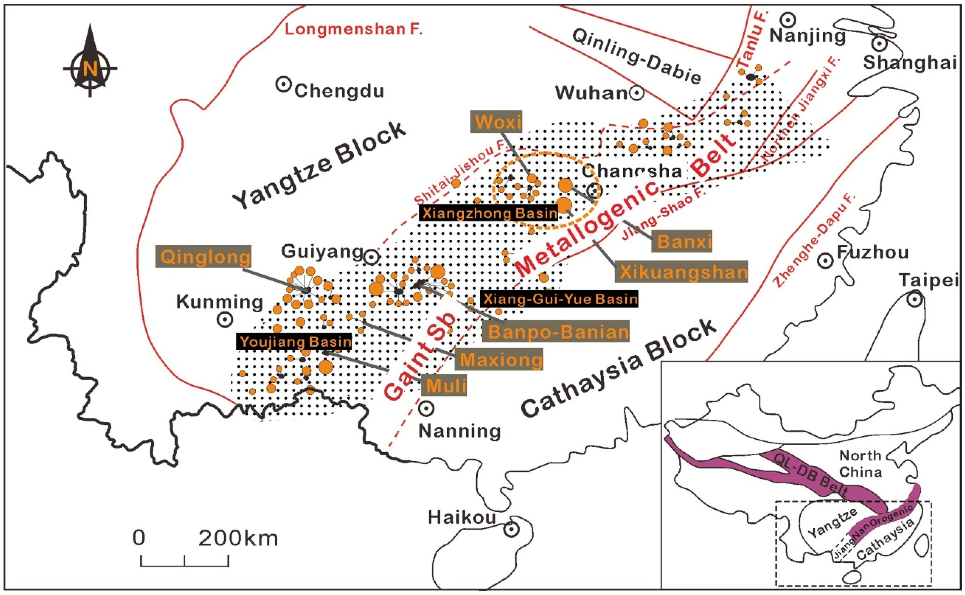
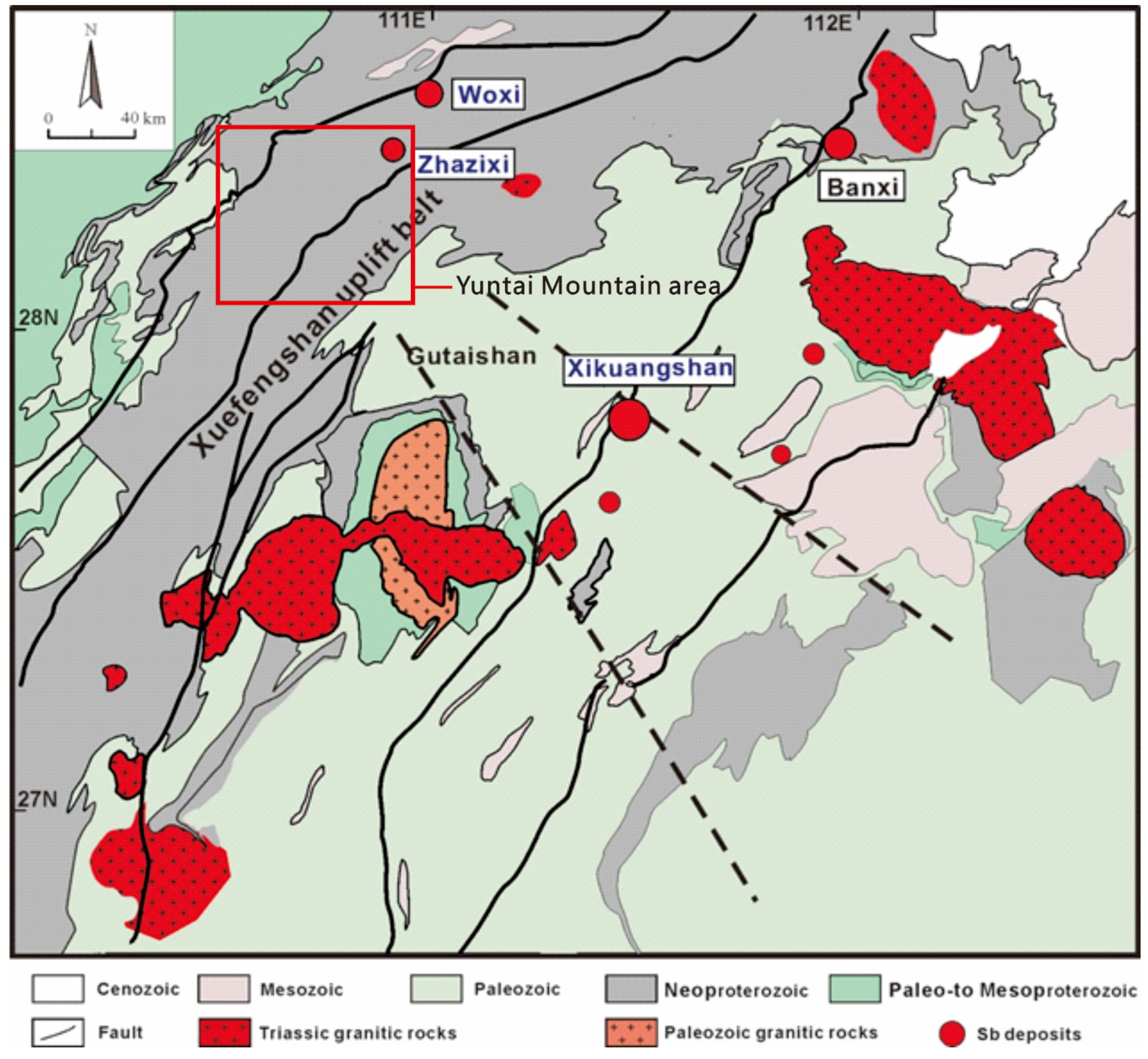
2.1. Regional Geology
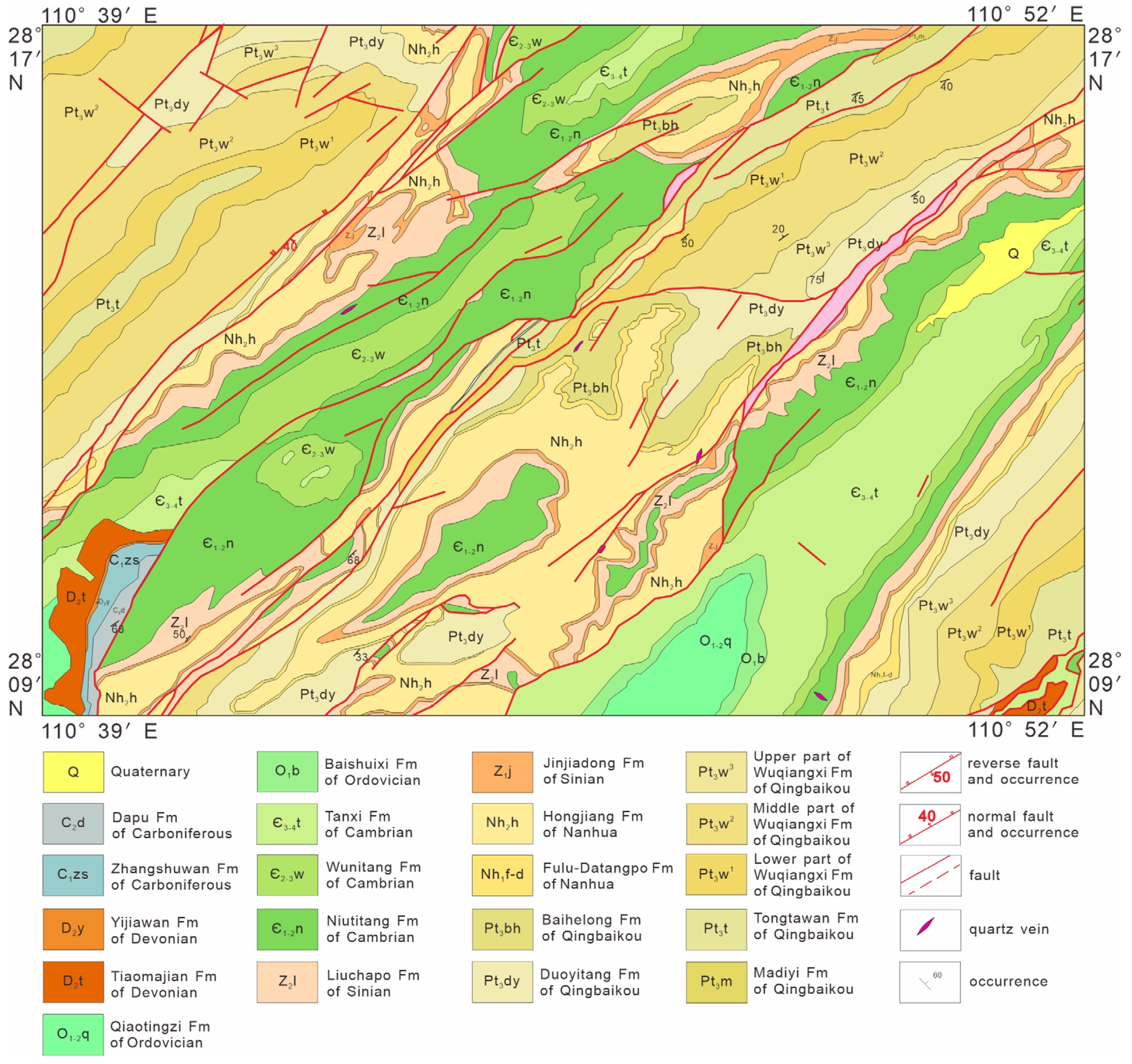
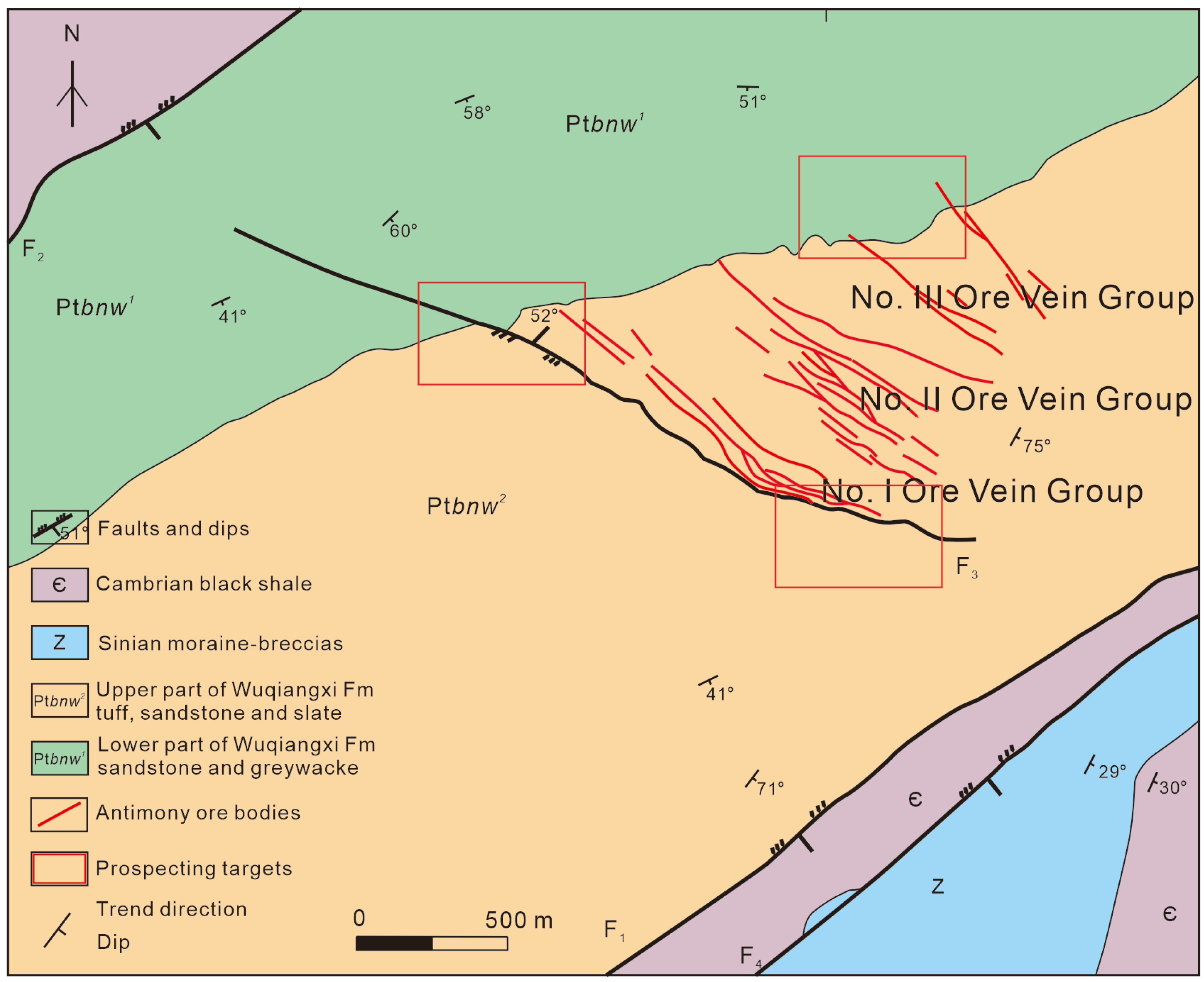
The Jiangnan orogenic belt (Figure 1 and Figure 2) represents a significant Neoproterozoic suture zone formed by the collision between the Yangtze and Cathaysia blocks, leading to the assembly of the South China Craton. It is characterized by complex structural features, including accretionary wedge, ophiolitic mélanges, and volcanic–sedimentary sequences, indicative of its dynamic tectonic history [20,21,22].
The region has undergone multiple orogenic events, notably during the Neoproterozoic, mid-Paleozoic, Triassic, and Early Cretaceous periods. These events have resulted in diverse magmatic, metamorphic, and deformational processes, significantly influencing the metallogenic evolution of the area. The Jiangnan orogenic belt hosts numerous mineral deposits, including antimony (Sb) and gold (Au), which are likely associated with hydrothermal systems [23]. For example, it contains over 250 gold deposits and occurrences, with a total estimated resource exceeding 970 tons of gold [3]. On the other hand, the timing of mineralization in the belt is complex, with evidence pointing to multiple episodes. For instance, metallogenic studies on the Tuanshanbei gold deposit, located at the central part of the belt, indicate two distinct gold mineralization events: the first occurred around 415 Ma, and the second at approximately 234 Ma [23]. The gold mineralization is characterized by auriferous sulfide-bearing quartz veins hosted within granodiorite host rocks. Furthermore, these events are associated with different deformation phases, reflecting the prolonged tectonic activity of the region [3,23,24,25].
Despite extensive research, gaps remain in understanding the structural controls of mineralization within the belt. Although the association between fault systems and ore deposition is recognized, the specific mechanisms by which structural features influence fluid flow and mineral precipitation are not fully elucidated. Detailed structural analysis, particularly in less studied areas like the Yuntai Mountain region, is essential to unravel these complexities.
Figure 1. Regional map showing the structural framework of the Jiangnan orogenic belt in South China, showing the distribution of metal (Sb-Au) occurrences (refer to orange dots) (after Yan et al., 2022) [26].
Minerals 15 00452 g001
Figure 2. Simplified geological map of the Jiangnan orogenic belt (South China block), showing the distributions of regional structures, the main sedimentary strata, and granitoid intrusions with the locations of significant Au/Au-Sb/Sb deposits. Abbreviations: NCB, North China Block. Abbreviations for regional faults: ALF, Anhua–Liping; AXF, Anhua–Xupu; CPF, Changsha–Pingjiang Fault; DYF, Dayong Fault; JSF, Jiangshan–Shaoxing Fault; LHF, Liling–Hengdong Fault; TCF, Taojiang–Chengbu Fault; XHF, Xinning–Huitang Fault; XJF, Xupu–Jingxian (after Zhang et al., 2019) [27].
Minerals 15 00452 g002

2.2. Local Geology

The study area, Yuntai Mountain region, is located in the central segment of the Jiangnan orogenic belt. It spans coordinates ranging from latitude 28° 09’ N to 28° 17’ N and longitude 110° 39’ E to 110° 52’ E, situated within Hunan Province, South China. The Yuntai Mountain area exhibits numerous strata, spanning the period from the Neoproterozoic to the Cenozoic (Figure 3). These strata are successively divided from the earliest to latest periods as follows: the Lengjiaxi Group and Banxi Group of the Qingbaikou System; Changan Formation; Fulu Formation; Datangpo Formation and Hongjiang Formation of the Nanhua System; Jinjiadong Formation; Liuchapo Formation of the Sinian System; Niutitang Formation; Wunitang Formation and Tanxi Formation of the Cambrian System; Baishuixi Formation; Qiaotingzi Formation; Yanxi Formation of the Ordovician System; Tiaomajian Formation; Yijiawan Formation; Qiziqiao Formation of the Devonian System; Zhangshuwan Formation; Dapu Formation of the Carboniferous System; Liangshan Formation; Qixia Formation of the Permian System; Shimen Formation; and Dongjing Formation of the Cretaceous System and Quaternary [15,16,17].
In this area, gold–antimony deposits are mainly found in the Lengjiaxi Group, Banxi Group, and Changan Formation. Some antimony deposits are also found in the Jinjiadong Formation, Liuchapo Formation of the Sinian System, and the Qiaotingzi Formation of the Ordovician System [16]. Antimony mineralization is also observed at the bottom of the Cambrian Niutitang Formation. Extensive studies have been conducted on the typical antimony deposits in the Yuntai Mountain area. Regarding the Zhazixi antimony deposit (Figure 4), it is now understood to have formed during the Late Jurassic (160–150 Ma) rather than the previously suggested Late Triassic period [17]. The antimony ore-forming fluids exhibit low temperature, low salinity, medium density, and high pressure [15,28]. The mineralization is most likely associated with early Mesozoic intracontinental orogeny, with fluid mixing playing a critical role in tungsten mineralization and fluid cooling being the primary mechanism for antimony mineralization [15]. The lithology of the outcropped units in the Zhazixi antimony deposit is Cambrian black shale; Sinian moraine–breccias; the upper part of the Wuqiangxi Formation consisting of tuff, sandstone, and slate; and the lower part of the Wuqiangxi Formation consisting of sandstone and greywacke. The main faults are the Yuexi fault (F1) and Majiaxi fault (F2) in the northeast direction and F3 in the northwest direction.
The Yuntai Mountain area contains a few magmatic rocks, primarily granite, with rock masses mainly dating back to the Silurian period. The sedimentary rock strata are well preserved and diverse, including sandstone, limestone, carboniferous shale, siliceous rock, and morainic conglomerate. Notably, the region exhibits complex deformation with various types and episodes of metamorphism having developed. The predominant metamorphic rocks are slates, which serve as ore-bearing strata for the formation of gold–antimony deposits.
Figure 4. Simplified geological map of the Yuntai Mountain–Xiangzhong basin, showing the location of the Zhazixi deposit (after Hu et al., 2017) [29].
Minerals 15 00452 g004

3. Materials and Methods

In this study, detailed fieldwork was carried out in the Yuntai Mountain area, targeting rock formations from the Qingbaikou, Sinian, Cambrian, and Ordovician periods. The fieldwork spanned over 100 km of survey route, encompassing more than 40 field observation points and yielding 50 sets of reliable structural orientation data (Table S1).
The field investigation employed a range of specialized equipment to ensure precise and comprehensive data collection. A geological compass (Brunton Compass) was used to measure the strike and dip of structural features such as bedding planes, foliation, and joints. A handheld GPS device recorded the exact geographic coordinates of each observation station, facilitating accurate spatial mapping of geological features. Additional tools (i.e., measuring taps and rulers) were used to document structural dimensions, while a high-resolution camera captured detailed imagery of outcrops and mineralized zones for subsequent analysis.
The structure alignments formed by different structural deformation events were systematically identified and measured during the fieldwork, with a focus on outcrops exhibiting multiple foliation planes and joint sets. Key observations included cross-cutting relationships, superposition, displacement, and deformation textures, which were analyzed to infer the sequence of structural events. Representative rock samples were collected to complement field data.
Following the field investigation, the collected data were classified and summarized for statistical analysis. Orientation data for foliation and joint sets were distinguished based on their distribution and characteristics. The chronological sequence of brittle deformation events was established through detailed structural analysis. This analysis included cross-cutting relationships between faults, multiple striae generations on fault surfaces, kinematic incompatibility analysis of parallel faults, and identification of syn-formation and depositional structure lineaments. The structure measurements were processed using Win-Tensor software(Version 5.0.1), following Angelier’s methodology [30].
All stereographic projections are presented in hemisphere equal-area projection. Using orientation data for foliation and joint sets in the Orient software (Version 3.14.0.20) [31,32], stereographic projections and rose diagrams were generated to visualize the spatial patterns of structural alignments. Based on these stereographic projections and rose diagrams, and supplemented by the character and occurrence of various faults and the character of different folds, the tectonic stress states of different structural deformation episodes can be preliminarily inferred. These analyses revealed dominant structural trends and their potential role in controlling fluid flow and mineral deposition.
Geometric and kinematic analyses were conducted to understand the deformation mechanisms and their influence on metal accumulation [33,34]. More specifically, the geometry and movement history of structural lineaments, including faults and folds, were examined to reconstruct the structural stress fields associated with each deformation phase. The principle of the procedure is that based on the occurrence and movement direction of the faults, joints, and foliation, we can primarily judge their stress state, because if a fault is a normal fault, then its stress state should be extended perpendicularly to the normal fault line. Using the classical inversion method, the stress regimes responsible for the observed structural configurations were determined. This reveals the formation mechanism and evolution process of the tectonic system in the study area.

4. Results and Discussion

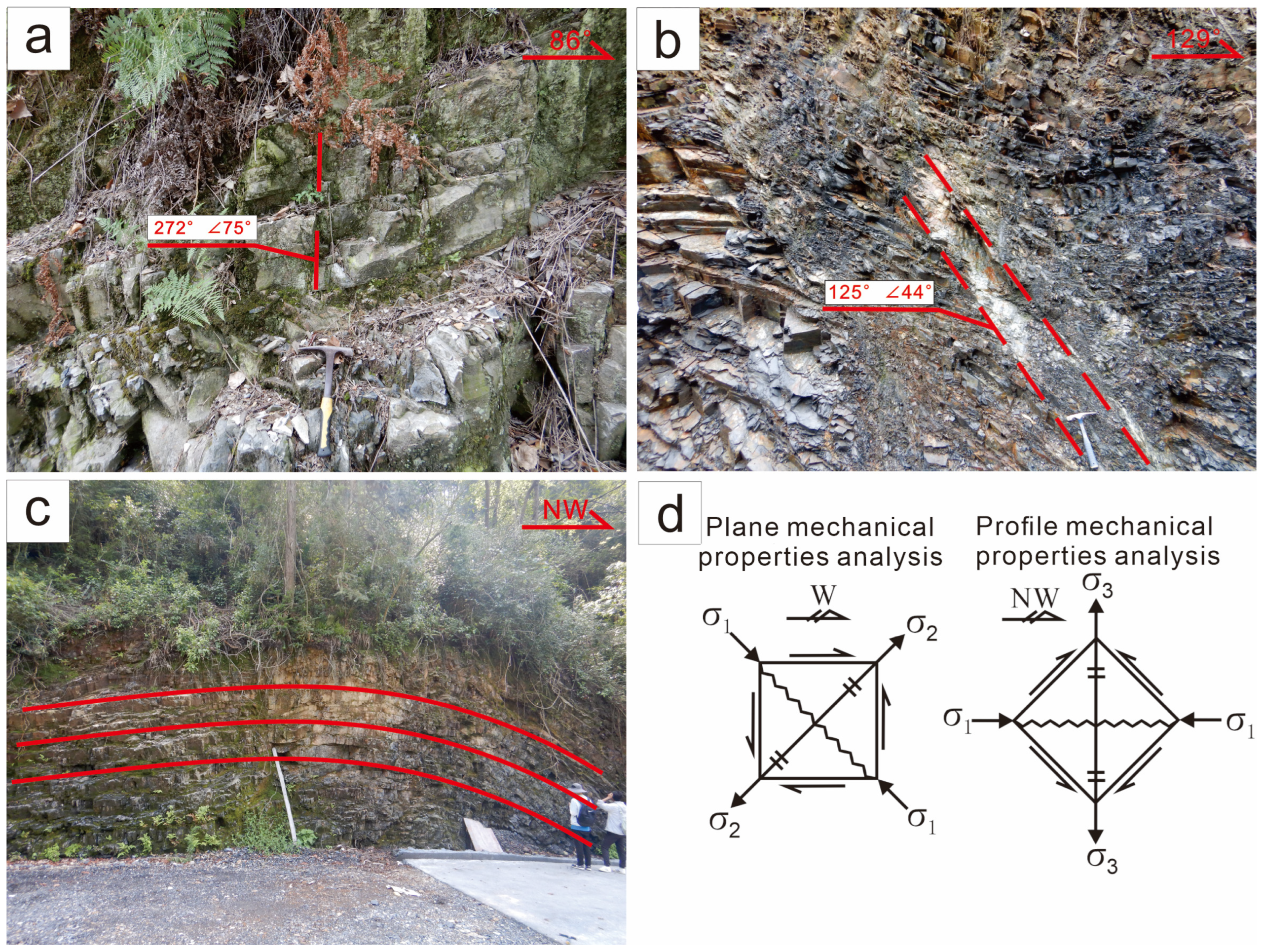
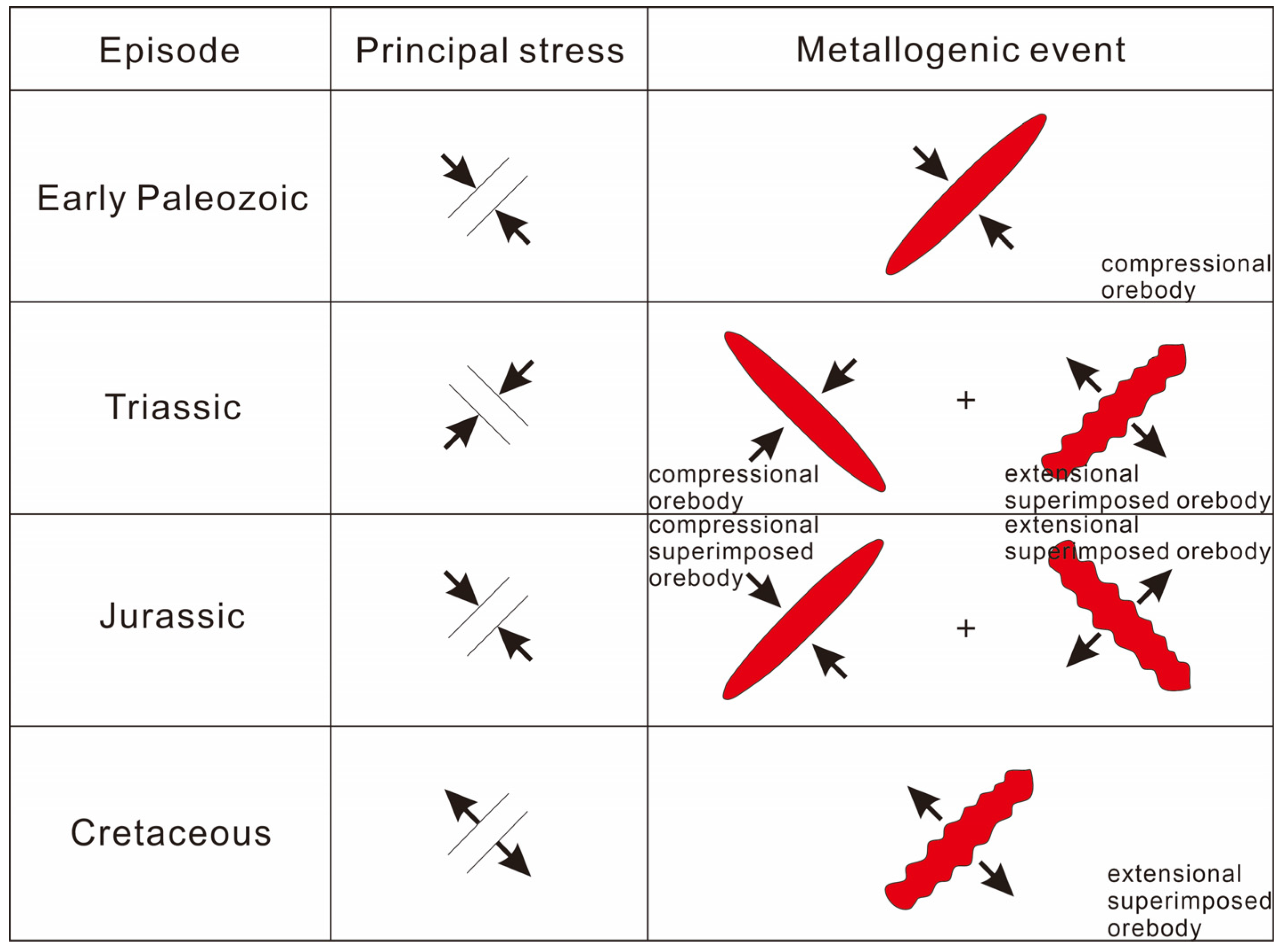
4.1. Analysis of Four Episodes of Tectonic Events

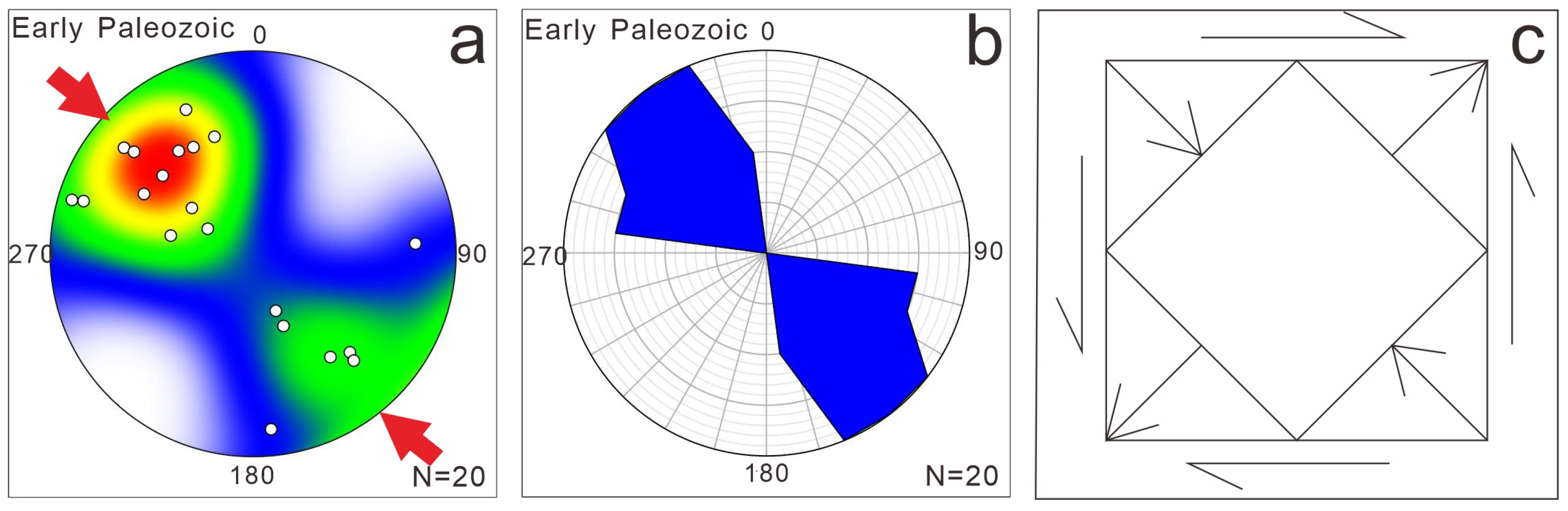
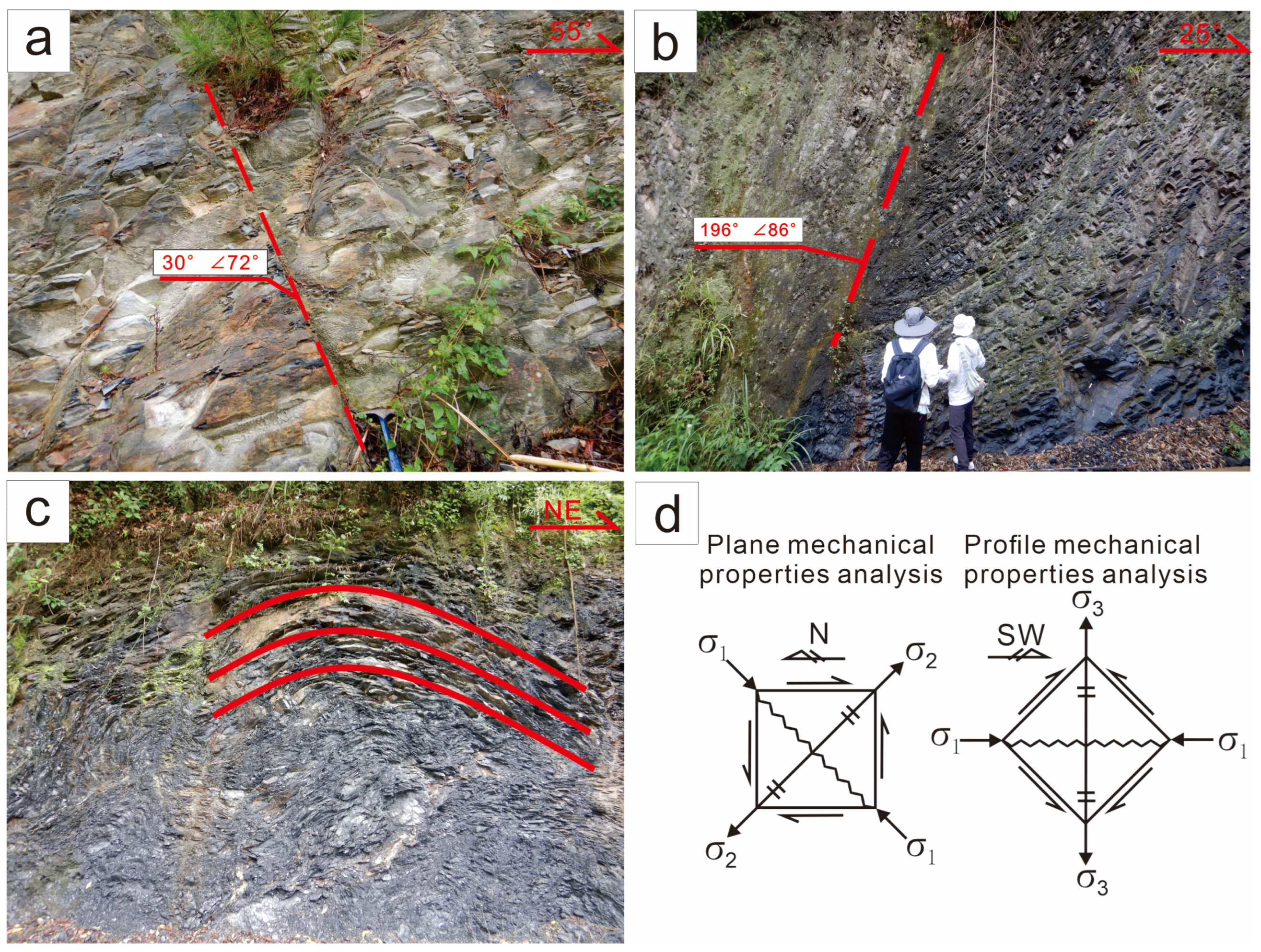
4.1.1. Early Paleozoic NW-SE Compression

According to field data and previous research results, NW-SE compression is the earliest tectonic deformation in the region, which is determined to have occurred in the Early Paleozoic. This compressional event formed the NE-SW-trending Xuefeng thrust belt. The Xuefeng thrust belt as a secondary tectonic belt, along with the Wuling low fold belt, constitutes the Xuefeng tectonic belt.
A large number of joints and faults have developed in the Neoproterozoic Qingbaikou and Early Paleozoic Cambrian strata (Figure 5). Figure 5a shows the Cambrian–Carboniferous shale with nearly horizontal bedding and distinct cleavage. The cleavage occurrence is 272°∠75° (dip direction∠dip angle; same as below) with a strike of NNE-SSW. Figure 5b depicts a Cambrian–Carboniferous slate with an occurrence of 187°∠26°. This slate was later transformed by faults, with lenses that can be seen in the fault zone. The fault plane occurrence is 125°∠44°, indicating a thrust fault with a strike of NNE-SSW. Figure 5c displays the Cambrian–Carboniferous strata forming an open fold. The NW limb occurrence is 340°∠35°, and the SE limb occurrence is 95°∠27°, with a strike of NW. These observations indicate that the compressional event with maximum principal stress σ1 in the NW-SE direction (both plane and profile; Figure 5d) occurred in the Early Paleozoic, as evidenced by the NE-SW-trending cleavage and faults and the NW-trending folds. This further confirms significant NW-SE compressional events during the Early Paleozoic in the study area.
Based on the measured data from the area, the classical inversion method and the foliation rose diagram (Figure 6) were used to invert the paleotectonic stress field of this episode. The inversion results show that the maximum and minimum principal stress directions of the Early Paleozoic NW-SE compressional deformation episode in the study area are as follows: σ1 approximates NW-SE; σ3 approximates NE-SW.

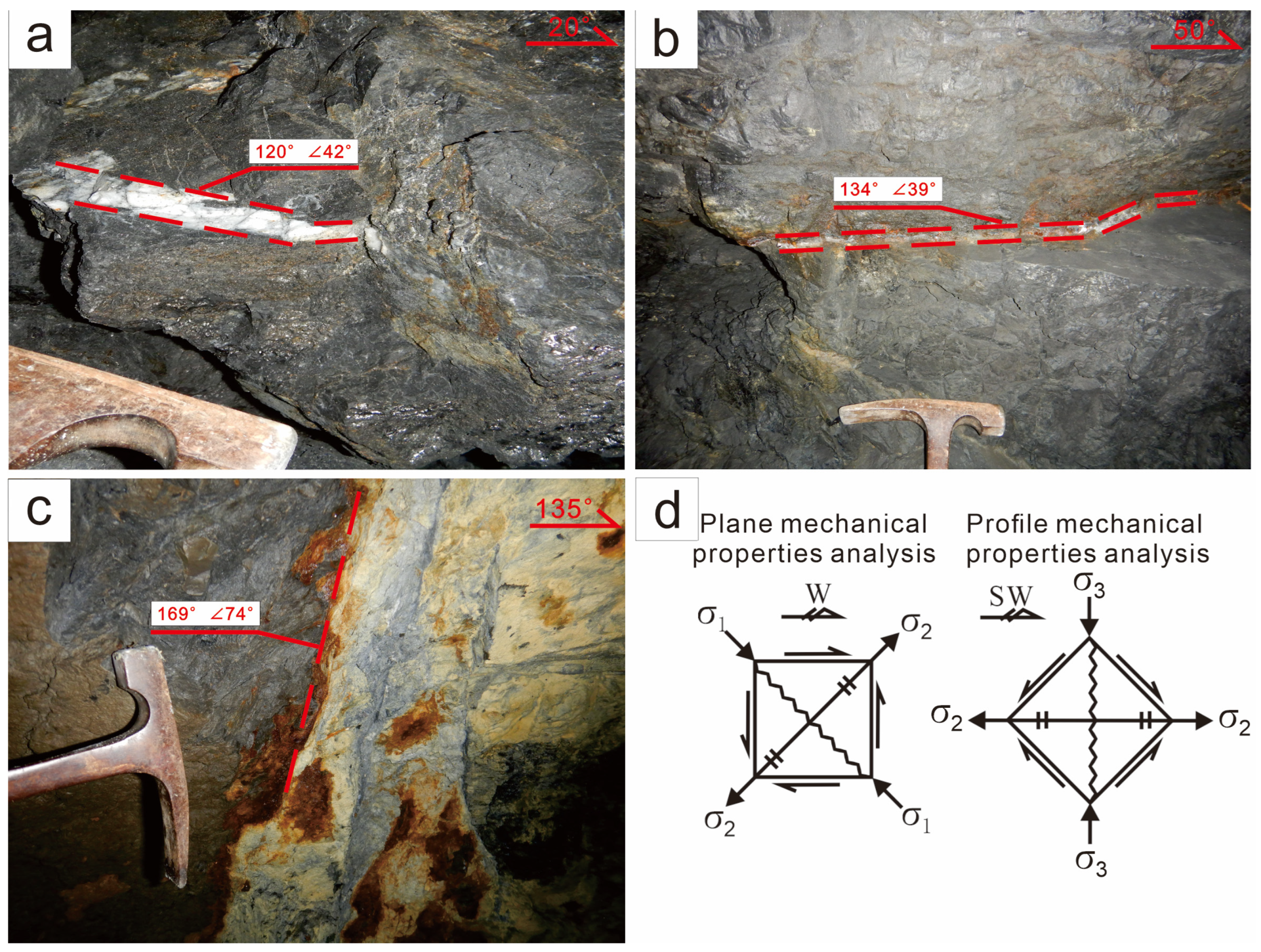
4.1.2. Triassic NE-SW Compression

The Triassic NE-SW compressional tectonic event led to the formation of NW-SE buried faults in the Yuntai Mountain area. The joints and faults in the Early Paleozoic Cambrian and Ordovician strata also record the compressional tectonic event of the Triassic (Figure 7). Figure 7a shows the Cambrian slate with the occurrence of 323°∠72° and a prominent joint with an occurrence of 30°∠72°, striking NWW-SEE. Figure 7b depicts a Cambrian–Carboniferous slate with an occurrence of 158°∠40°, intersected by a high-angle reverse fault. The occurrence of the fault plane is 196°∠86°, and the fault strike is NWW-SEE. Figure 7c illustrates the Cambrian continuous fold, with the occurrence of 58°∠32° on the northeast limb and 162°∠57° on the southwest limb, and the strike of the fold is NE. The above joints and faults are basically striking NW-SE. At the same time, the NE-trending fold further confirms the occurrence of the compressional event with maximum principal stress σ1 in the NE-SW direction (both plane and profile; Figure 7d) during the Triassic.
According to the measured data in the area, the classical inversion method and the foliation rose diagram (Figure 8) were used to reconstruct the paleotectonic stress field of this episode. The inversion results indicate that the maximum principal stress direction (σ1) of the Triassic NE-SW compressional deformation episode approximates NE-SW, while the minimum principal stress direction (σ3) approximates NW-SE.

4.1.3. Jurassic NW-SE Compression

The Jurassic NW-SE compressional tectonic event is similar to the Early Paleozoic NW-SE compressional tectonic event. The Jurassic NW-SE compressional tectonic event developed a series of NE-SW-trending mineral veins and faults in the study area (Figure 9). Figure 9a displays the stibnite vein with the occurrence of 120°∠42° and a strike of NNE-SSW. In addition, Figure 9b shows the stibnite calcite vein with the occurrence of 134°∠39° and strike of NE-SW, while Figure 9c shows the morainic conglomerate. Sulfur is found on the surface of the fault fracture zone, the occurrence of the fault plane is 169°∠74°, and the fault strike is NEE-SWW. These mineral veins and faults are principally striking NE-SW, confirming the occurrence of the compressional event with maximum principal stress σ1 in the NW-SE direction (both plane and profile; Figure 9d) during the Jurassic.

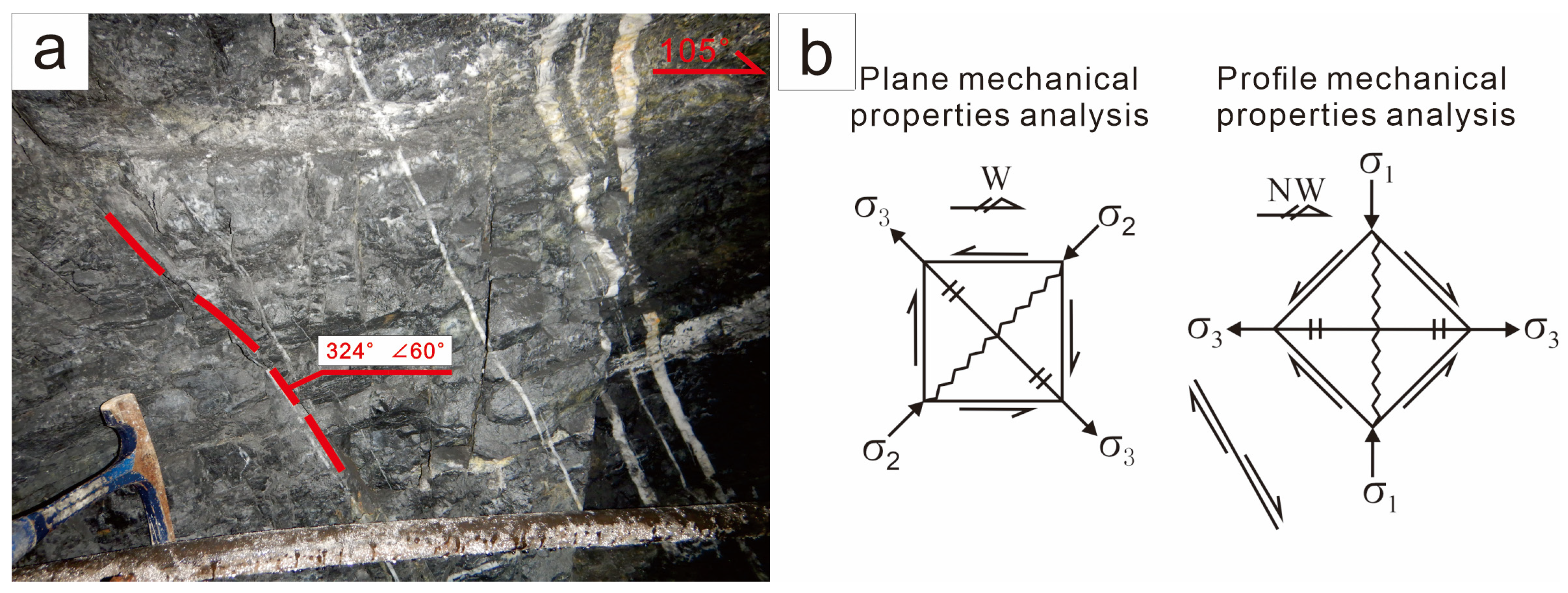
4.1.4. Cretaceous NW-SE Extension

The Cretaceous NW-SE extensional tectonic event formed the NE-SW faults in the region. This period was marked by intense magmatic activity, with the faults and tension spaces created during the extension process providing channels for the migration of magma and hydrothermal solution, as well as storage space for these materials. In the field, normal faults and quartz veins can be observed filling the spaces formed by this tectonic event (Figure 10). More specifically, Figure 10a shows the normal fault with a series of nearly parallel quartz veins around it, and a small amount of stibnite can be seen. The fault plane occurrence is 324°∠60°, and the fault strike is NEE-SWW. The orientation of the normal fault supports the occurrence of the extensional event with minimum principal stress σ3 in the NW-SE direction (both plane and profile; Figure 10b) during the Cretaceous (for normal tensile faults, the direction of the minimum principal stress σ3 represents the direction of the extensional event).

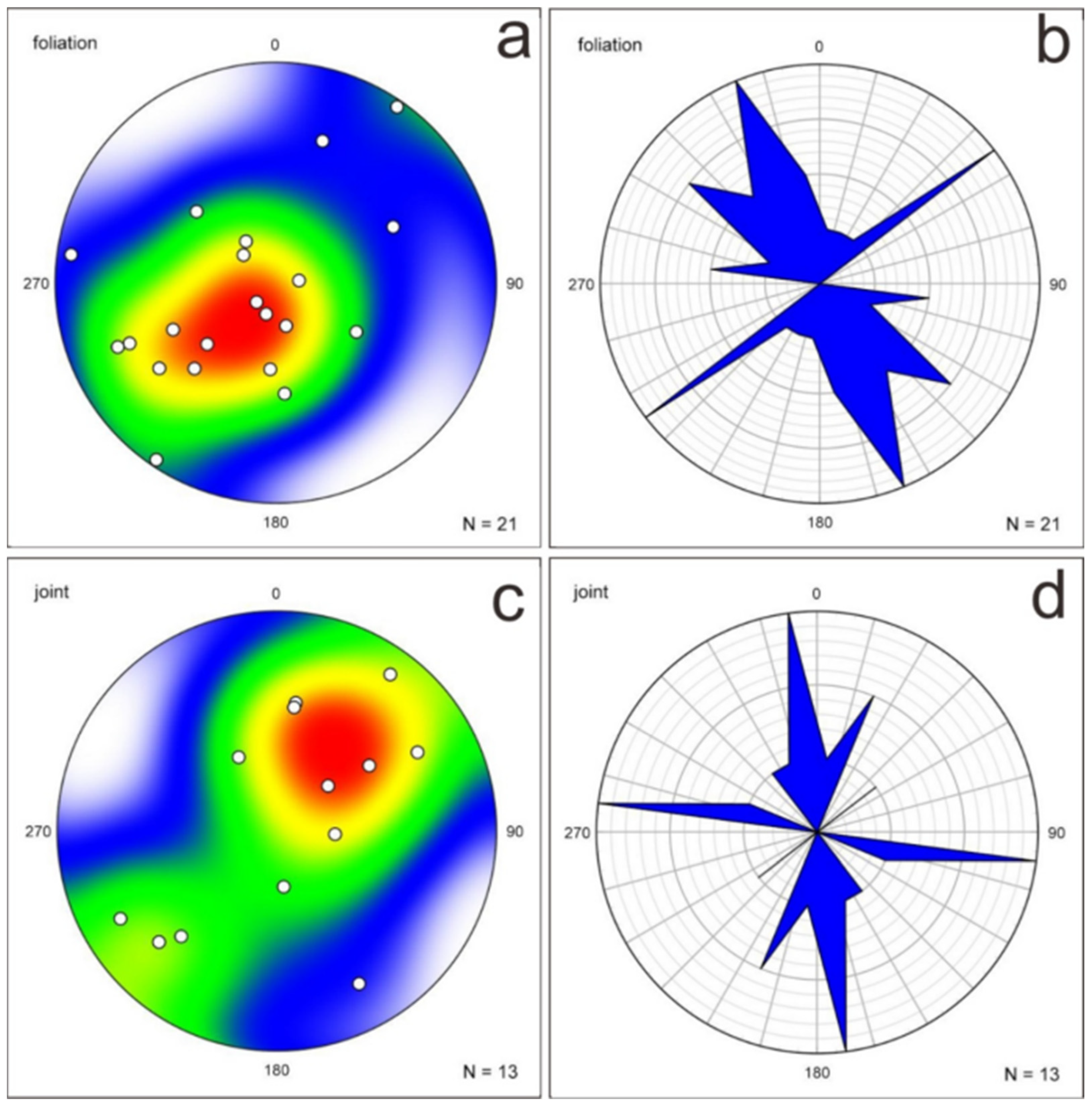
4.2. Structural Characteristics of Strata and Mineral Veins

4.2.1. Strata

In this field investigation, a total of 25 fixed points were collected in the stratigraphic outcrop, and 21 sets of effective foliation occurrence data and 13 sets of effective joint occurrence data were collected. The Neoproterozoic Qingbaikou System, Sinian System, Early Paleozoic Cambrian System, and Ordovician System can be seen in the stratigraphic outcrop. The predominant lithology is slate, with minor amounts of sandstone, limestone, carboniferous shale, siliceous rock, and morainic conglomerate.
The data of rock foliation and joint occurrence in visible strata were statistically analyzed using the lower hemisphere equal area projection and rose diagram, respectively, and the results are shown in Figure 11. It can be seen from this figure that the main trend in rock foliation is NE-SW, which is consistent with the trend in the Xuefeng thrust belt in the Yuntai Mountain area, followed by NW-SE. The main trend in various rock joints is NE-SW, which is consistent with the main trend in rock foliation. Given that the Neoproterozoic Qingbaikou, Sinian, Early Paleozoic Cambrian, and Ordovician are the older layers in the study area, multiple episodes of tectonic events can be recorded. The foliation occurrence data are fundamentally concentrated in the NE-SW direction, while a small portion is distributed in the NW-SE direction. From the main occurrence data, it is inferred that the strata mainly recorded the NW-SE compressional tectonic event in the Early Paleozoic and the NE-SW compressional tectonic event in the Triassic. The NE-SW-trending foliation and joints were produced by the NW-SE compression in the Early Paleozoic. In contrast, the NE-SW compression in the Triassic period produced the NW-SE-trending foliation and joints.

4.2.2. Ore Veins

During this field investigation, data were collected from 17 fixed points in the underground veins, resulting in 21 sets of effective foliation occurrence data and 13 sets of effective joint occurrence data. The underground veins are mainly composed of stibnite, quartz, and calcite, with a small amount of gangue materials (i.e., moraine conglomerate, siliceous rock, and sandstone) also present.
The occurrence data of mineral veins were statistically analyzed using lower hemisphere equal area projection and a rose diagram, as shown in Figure 12. The analysis indicates that the main trend in mineral veins is NE-SW, followed by NW-SE. Since the mineral veins were formed during the Triassic episode, they record various tectonic events from the Jurassic–Cretaceous and later periods. The occurrence data of mineral veins are predominantly distributed in the NE-SW direction, with a small part in the NW-SE direction. This implies that the mineral veins primarily recorded NW-SE tectonic events, including the Jurassic NW-SE compressional tectonic event and the Cretaceous NW-SE tensional tectonic event.

4.3. Implications for Ore Exploration

Analysis of antimony–gold deposit structures in the Yuntai Mountain area reveals a distinct sequence of tectonic evolution and metallogenic events (Figure 13). Four key phases characterize this evolution: (1) Early Paleozoic NW-SE compression generating NE-SW-trending orebodies; (2) Triassic NE-SW compression forming NW-SE-trending orebodies while modifying pre-existing Early Paleozoic NE-SW structures through superimposed passive NW-SE extensional stress; (3) Jurassic reactivation of NW-SE compression creating additional NE-SW-trending orebodies, while simultaneously transforming the Triassic NW-SE-trending orebodies by superimposed passive NE-SW extensional stress; (4) Cretaceous NW-SE extension producing the final NE-SW-trending extensional orebodies.
Based on the above analysis, the controlling factors of representative deposits at various levels were preliminarily determined, and tectonic genetic models of different ore deposits with varying strikes were constructed. The main findings are as follows: (1) the sites for ore deposition of NE-SW antimony veins are controlled by NW-SE compression in the Early Paleozoic, NW-SE compression in the Jurassic, and NW-SE extension in the Cretaceous. These veins exhibit characteristics of multi-episode tectonic events, which are favorable to hydrothermal events, making them a priority for prospecting deposits in the Yuntai Mountain area; (2) NE-SW compression primarily influences the ore-bearing structure of the NW-SE antimony veins in the Triassic, which can serve as a secondary prospecting target; (3) the intersection of regional structures represents a favorable location for mineralization and should be designated as a significant regional prospecting target. Taking the Zhazixi Sb deposit in the region as an example, we identified potential ore-prospecting areas (Figure 14).

4.4. Future Research Directions

The Yuntai Mountain area, located in western Hunan Province, represents a significant metallogenic zone within the Jiangnan orogenic belt, hosting economically important accumulations of metals (i.e., Sb and Au). Despite the extensive research conducted to date, there remain substantial opportunities for advancing our understanding of the mineralization processes and structural controls of the region. As a result, future research should focus on the following key points:
(a)
Detailed geochemical and isotopic analysis could improve our understanding of ore-forming fluid sources and pathways. In addition, radiometric dating using U-Pb and Re-Os isotopic systems could be used to refine the timing of mineralization and correlate it with regional tectonic events.
(b)
The use of advanced geophysical methods, such as 3D seismic imaging and gravity inversion, can provide deeper insights into the subsurface structures controlling the metal flow and precipitation.
(c)
High-resolution remote sensing tools could enhance the detection of alteration zones associated with metal occurrences within the Yuntai Mountain area and delineate surface structural lineaments, allowing for more precise targeting of potential ore deposits.

5. Conclusions

This study integrates detailed field observations, stereographic projections, and stress field reconstructions to establish a robust framework for predicting the spatial distribution of ore deposits in the Yuntai Mountain area. The following key conclusions can be drawn:
(a)
The Yuntai Mountain area in Hunan Province has experienced a complex tectonic history, shaped by four major tectonic events: (1) Early Paleozoic NW-SE compression, (2) Triassic NE-SW compression, (3) Jurassic NW-SE compression, and (4) Cretaceous NW-SE extension. These tectonic episodes have played a pivotal role in controlling the structural evolution and mineralization processes in the region.
(b)
The NE-SW antimony veins demonstrate a clear association with the NW-SE compressional regimes of the Early Paleozoic and Jurassic periods, as well as the NW-SE extensional regime of the Cretaceous period. These multi-phase tectonic processes created favorable conditions (structural pathways and traps) for hydrothermal fluids activities, leading to the development of mineralized veins, which represent primary targets for future mineral prospecting in the study area.
(c)
The Triassic NE-SW compression significantly influenced the ore-bearing structures of the NW-SE antimony veins through oblique compressional forces. This compression not only reactivated pre-existing structures but also formed new fractures, which acted as conduits for hydrothermal solution migrations and subsequent metal deposition. Consequently, the NW-SE-oriented veins represent a secondary target for mineral prospecting.
(d)
The intersections of regional structures, such as faults, fractures, and foliation planes, emerge as critical sites for enhanced mineralization. These structural intersections serve as zones of increased permeability, promoting fluid mixing, pressure drops, and chemical reactions conducive to ore precipitation. The identification and detailed mapping of these intersections are, therefore, essential for delineating high-potential areas for mineral exploration.
(e)
The findings underscore the need for further investigations, including geochemical and geophysical studies, to refine exploration models. Particular attention should be given to areas where structural intersections coincide with favorable lithological units, as these locations host economically significant ore deposits.

Supplementary Materials

The following supporting information can be downloaded at: https://www.mdpi.com/article/10.3390/min15050452/s1, Table S1: Statistical table of the attitude of foliation, joint and fault in the study area.

Author Contributions

Conceptualization, S.C. and H.L.; methodology, S.C., J.W. and M.F.; validation, H.L., J.Z. and M.F.; formal analysis, S.C. and Z.Z.; investigation, S.C., H.L., J.Z. and J.X.; writing—original draft preparation, S.C., H.L., J.Z. and J.X.; writing—review and editing, S.C., H.L., J.Z., J.X. and M.F.; supervision, H.L.; project administration, S.C. and H.L.; funding acquisition, S.C. and H.L. All authors have read and agreed to the published version of the manuscript.

Funding

This research was funded by the Changsha General Survey of the Natural Resources Centre, China Geological Survey, grant number DD20220968.

Data Availability Statement

All additional data are provided in the Supplementary Materials.

Acknowledgments

The authors are thankful for the research funds from the China Geological Survey.

Conflicts of Interest

The authors declare no conflicts of interest regarding the publication of this article.

References

  1. Li, P.; Li, J.; Liu, X.; Li, C.; Huang, Z.; Zhou, F. Geochronology and source of the rare-metal pegmatite in the Mufushan area of the Jiangnan orogenic belt: A case study of the giant Renli Nb–Ta deposit in Hunan, China. Ore Geol. Rev. 2020, 116, 103237. [Google Scholar] [CrossRef]
  2. Zhao, L.; Guo, F.; Fan, W.; Zhang, Q.; Wu, Y.; Li, J.; Yan, W. Early Cretaceous potassic volcanic rocks in the Jiangnan Orogenic Belt, East China: Crustal melting in response to subduction of the Pacific–Izanagi ridge? Chem. Geol. 2016, 437, 30–43. [Google Scholar] [CrossRef]
  3. Xu, D.; Deng, T.; Chi, G.; Wang, Z.; Zou, F.; Zhang, J.; Zou, S. Gold mineralization in the Jiangnan Orogenic Belt of South China: Geological, geochemical and geochronological characteristics, ore deposit-type and geodynamic setting. Ore Geol. Rev. 2017, 88, 565–618. [Google Scholar] [CrossRef]
  4. Liang, Y.; Zheng, H.; He, Z.; De Grave, J.; Li, H.; Tang, Z.; Lash, G.G.; Kang, P. Reassessing early to mid-Neoproterozoic (∼885–720 Ma) tectonic evolution of the southwestern Jiangnan Orogen: A detrital zircon perspective. Precambrian Res. 2024, 410, 07482. [Google Scholar] [CrossRef]
  5. Wang, C.; Shao, Y.; Chen, X.; Zhang, X.; Li, H.; Wei, H.; Liu, Q. Genesis of the Jinji gold deposit in the Jiangnan Orogen, South China: Constraints from geology, chlorite geochemistry, age and HOS-Pb isotopes. Ore Geol. Rev. 2023, 155, 105352. [Google Scholar] [CrossRef]
  6. Wang, C.; Shao, Y.; Zhang, X.; Lai, C.; Liu, Z.; Li, H.; Chao, G.; Liu, Q. Metallogenesis of the Hengjiangchong gold deposit in Jiangnan orogen, South China. Ore Geol. Rev. 2020, 118, 103350. [Google Scholar] [CrossRef]
  7. Li, H.; Zhou, Z.K.; Algeo, T.J.; Wu, J.H.; Jiang, W.C. Geochronology and geochemistry of tuffaceous rocks from the Banxi Group: Implications for Neoproterozoic tectonic evolution of the southeastern Yangtze Block, South China. J. Asian Earth Sci. 2019, 177, 152–176. [Google Scholar] [CrossRef]
  8. Li, H.; Wu, Q.H.; Evans, N.J.; Zhou, Z.K.; Kong, H.; Xi, X.S.; Lin, Z.W. Geochemistry and geochronology of the Banxi Sb deposit: Implications for fluid origin and the evolution of Sb mineralization in central-western Hunan, South China. Gondwana Res. 2018, 55, 112–134. [Google Scholar] [CrossRef]
  9. Li, H.; Zhu, D.P.; Shen, L.W.; Algeo, T.J.; Elatikpo, S.M. A general ore formation model for metasediment-hosted Sb-(Au-W) mineralization of the Woxi and Banxi deposits in South China. Chem. Geol. 2022, 607, 121020. [Google Scholar] [CrossRef]
  10. Li, H.; Danišík, M.; Zhou, Z.K.; Jiang, W.C.; Wu, J.H. Integrated U–Pb, Lu–Hf and (U–Th)/He analysis of zircon from the Banxi Sb deposit and its implications for the low-temperature mineralization in South China. Geosci. Front. 2020, 11, 1323–1335. [Google Scholar] [CrossRef]
  11. Fu, S.; Zajacz, Z.; Tsay, A.; Hu, R. Can magma degassing at depth donate the metal budget of large hydrothermal Sb deposits? Geochim. Cosmochim. Acta 2020, 290, 1–15. [Google Scholar] [CrossRef]
  12. Fu, S.; Hu, R.; Batt, G.E.; Danišík, M.; Evans, N.J.; Mi, X. Zircon (U-Th)/He thermochronometric constraints on the mineralization of the giant Xikuangshan Sb deposit in central Hunan, South China. Miner. Depos. 2020, 55, 901–912. [Google Scholar] [CrossRef]
  13. Krinov, L. A review on the Mineralogy of Stibnite in Hydrothermal Gold Deposits. Acad. J. Earth Sci. 2024, 2, 16–20. [Google Scholar]
  14. Zhang, D.; Pan, J.; Gao, J.; Dai, T.; Bayless, R.C. In situ LA ICP-MS analysis of trace elements in scheelite from the Xuefeng Uplift Belt, South China and its metallogenic implications. Ore Geol. Rev. 2021, 133, 104097. [Google Scholar] [CrossRef]
  15. Zeng, G.P.; Gong, Y.J.; Hu, X.L.; Xiong, S.F. Geology, fluid inclusions, and geochemistry of the Zhazixi Sb–W deposit, Hunan, South China. Ore Geol. Rev. 2017, 91, 1025–1039. [Google Scholar] [CrossRef]
  16. Li, H.; Zhou, Z.K.; Evans, N.J.; Kong, H.; Wu, Q.H.; Xi, X.S. Fluid-zircon interaction during low-temperature hydrothermal processes: Implications for the genesis of the Banxi antimony deposit, South China. Ore Geol. Rev. 2019, 114, 103137. [Google Scholar] [CrossRef]
  17. Wang, T.; Fu, S.; Tang, Y.; Wei, L. Scheelite U–Pb dating constraints on the timing of the formation of the Zhazixi Sb-W deposit in South China. Miner. Depos. 2024, 59, 445–452. [Google Scholar] [CrossRef]
  18. Yao, J.; Cawood, P.A.; Shu, L.; Zhao, G. Jiangnan orogen, South China: A ~970–820 Ma Rodinia margin accretionary belt. Earth-Sci. Rev. 2019, 196, 102872. [Google Scholar] [CrossRef]
  19. Bai, D.; Li, B.; Zhou, C.; Sun, J.; Wei, F.; Zeng, G.; Jiang, W.; Li, Y.; Jiang, Q. Gold mineralization events of the Jiangnan Orogen in Hunan and their tectonic settings. Chin. J. Petromineral. 2021, 40, 897–922. [Google Scholar]
  20. Li, B.; Xu, D.; Bai, D.; Chi, G.; Dai, J.; Gao, C.; Deng, T.; Zou, S.; Ma, W.; Wang, G.; et al. Structural deformation, metallogenic epoch and genetic mechanism of the Woxi Au-Sb-W deposit, Western Hunan Province, South China. Sci. China Earth Sci. 2022, 65, 2358–2384. [Google Scholar] [CrossRef]
  21. Cawood, P.A.; Wang, Y.; Xu, Y.; Zhao, G. Locating South China in Rodinia and Gondwana: A fragment of greater India lith-osphere? Geology 2013, 41, 903–906. [Google Scholar] [CrossRef]
  22. Li, X.; Wang, C.; Hua, R.; Wei, X. Fluid origin and structural enhancement during mineralization of the Jinshan orogenic gold deposit, South China. Miner. Depos. 2010, 45, 583–597. [Google Scholar] [CrossRef]
  23. Wang, C.; Shao, Y.J.; Goldfarb, R.; Tan, S.M.; Sun, J.; Zhou, C.; Zheng, H.; Liu, Q.Q.; Xiong, Y.Q. Superimposed Gold Min-eralization Events in the Tuanshanbei Orogenic Gold Deposit, Central Jiangnan Orogen, South China. Econ. Geol. 2024, 119, 113–137. [Google Scholar] [CrossRef]
  24. Wang, Y.; Fan, W.; Zhang, G.; Zhang, Y. Phanerozoic tectonics of the South China Block: Key observations and controversies. Gondwana Res. 2013, 23, 1273–1305. [Google Scholar]
  25. Ni, P.; Wang, G.G.; Chen, H.; Xu, Y.F.; Guan, S.J.; Pan, J.Y.; Li, L. An Early Paleozoic orogenic gold belt along the Jiang− Shao Fault, south China: Evidence from fluid inclusions and Rb–Sr dating of quartz in the Huangshan and Pingshui deposits. J. Asian Earth Sci. 2015, 103, 87–102. [Google Scholar] [CrossRef]
  26. Yan, J.; Fu, S.; Liu, S.; Wei, L.; Wang, T. Giant Sb metallogenic belt in South China: A product of Late Mesozoic flat-slab subduction of paleo-Pacific plate. Ore Geol. Rev. 2022, 142, 104697. [Google Scholar] [CrossRef]
  27. Zhang, L.; Yang, L.Q.; Groves, D.I.; Sun, S.C.; Liu, Y.; Wang, J.Y.; Li, R.H.; Wu, S.G.; Gao, L.; Guo, J.L.; et al. An Overview of Timing and Structural Geometry of Gold, Gold-Antimony and Antimony Mineralization in the Jiangnan Orogen, Southern China. Ore Geol. Rev. 2019, 115, 103173. [Google Scholar] [CrossRef]
  28. Jia, L.; Li, H.; Wang, L.; Zhang, D. Geochemical Characteristics of Fluid Inclusions and Isotopes in Zhazixi Sb-W Deposit. Int. J. Heat Technol. 2022, 40, 405. [Google Scholar] [CrossRef]
  29. Hu, R.Z.; Chen, W.T.; Xu, D.R.; Zhou, M.F. Reviews and new metallogenic models of mineral deposits in South China: An introduction. J. Asian Earth Sci. 2017, 137, 1–8. [Google Scholar] [CrossRef]
  30. Angelier, J. Determination of the mean principal directions of stresses for a given fault population. Tectonophysics 1979, 56, T17–T26. [Google Scholar] [CrossRef]
  31. Vollmer, F.W. C program for automatic contouring of spherical orientation data using a modified Kamb method. Comput. Geosci. 1995, 21, 31–49. [Google Scholar] [CrossRef]
  32. Delvaux, D.; Sperner, B. Stress tensor inversion from fault kinematic indicators and focal mechanism data: The TENSOR program. In New Insights into Structural Interpretation and Modelling; Geological Society: London, UK, 2003; Volume 212, pp. 75–100. [Google Scholar]
  33. Atif, Y.; Soulaimani, A.; Ait Lahna, A.; Yaagoub, D.; Youbi, N.; Pour, A.B.; Hashim, M. Structural analysis and paleostress evolution in the Imiter silver mining region, Eastern Anti Atlas, Morocco: Implications for mineral exploration. Minerals 2022, 12, 1563. [Google Scholar] [CrossRef]
  34. Wang, B.; Li, H.; Sun, Z.; Quan, W.; Huang, Y.; Faisal, M. Yingde–Guangning Granitic Plutons Record Complex Tectonic Evolution During Paleozoic-Mesozoic: Implications for Gold Exploration in Western Guangdong, South China. Minerals 2024, 14, 1259. [Google Scholar] [CrossRef]
Figure 3. Simplified geological map of the research area (Yuntai Mountain area).
Minerals 15 00452 g003
Figure 5. Early Paleozoic NW-SE compressional tectonic event and analysis of its mechanical properties. In (a), the lithology is carboniferous shale, and the red dotted line is the cleavage, while in (b), the lithology is carboniferous slate, and the red dotted line is the fault; in (c), the lithology is carboniferous slate, and the curves represent the fold; and in (d), the maximum principal stress σ1 is in the NW-SE direction (both plane and profile).
Minerals 15 00452 g005
Figure 6. (a) Projection of Early Paleozoic rock foliations in the research area (dip direction and dip angle); (b) rose diagram of Early Paleozoic rock foliations in the research area; (c) stress analysis of the Early Paleozoic in the research area.
Minerals 15 00452 g006
Figure 7. Triassic NE-SW compressional tectonic event and analysis of its mechanical properties. In (a), the lithology is slate, and the red dotted line indicates the joint; in (b), the lithology is carboniferous slate, and the red dotted line indicates the high-angle reverse fault; in (c), the curves represent the fold; and in (d), the maximum principal stress σ1 is in the NE-SW direction (both plane and profile).
Minerals 15 00452 g007
Figure 8. (a) Projection of Triassic rock foliations in the research area (dip direction and dip angle); (b) rose diagram of Triassic rock foliations in the research area; (c) stress analysis of the Triassic rocks in the research area.
Minerals 15 00452 g008
Figure 9. Jurassic NW-SE compressional tectonic event and analysis of its mechanical properties. (a) is the stibnite ore vein; (b) is the stibnite calcite vein; in (c), the red dotted line indicates the fault; and in (d), the maximum principal stress σ1 is in the NW-SE direction (both plane and profile).
Minerals 15 00452 g009
Figure 10. Cretaceous NW-SE extensional tectonic event and analysis of its mechanical properties. In (a), the red dotted line indicates the normal fault with nearly parallel ore veins visible around the fault; in (b), the minimum principal stress σ3 is in the NW-SE direction (both plane and profile).
Minerals 15 00452 g010
Figure 11. (a) Lower hemispherical equiareal projection of rock foliations (dip direction and dip angle); (b) rose diagram of rock foliations; (c) lower hemispherical equiareal projection of rock joints (dip direction and dip angle); (d) rose diagram of rock joints.
Minerals 15 00452 g011
Figure 12. (a) Lower hemispherical equiareal projection of mineral veins (dip direction and dip angle); (b) rose diagram of mineral veins.
Minerals 15 00452 g012
Figure 13. Schematic representation of the four-stage tectonic evolution of the Yuntai Mountain area and corresponding metallogenic events.
Minerals 15 00452 g013
Figure 14. A detailed geological map of the Zhazixi Sb deposit shows the area of ore prospecting and the distribution of mineralized veins.
Minerals 15 00452 g014
Disclaimer/Publisher’s Note: The statements, opinions and data contained in all publications are solely those of the individual author(s) and contributor(s) and not of MDPI and/or the editor(s). MDPI and/or the editor(s) disclaim responsibility for any injury to people or property resulting from any ideas, methods, instructions or products referred to in the content.

