Article

Application of High-Precision Magnetic Measurement in the Exploration of Deep Fluorite Deposits in Ore Concentrations

1
Mineral Resources Exploration Center Bureau of Henan Geological, Zhengzhou 450053, China
2
Henan Natural Resources Science Technology Innovation Center (Geophysical Deep Exploration Research), Zhengzhou 450053, China
3
Henan Geological Bureau, Zhengzhou 450016, China
4
School of Resources and Environment, Henan Polytechnic University, Jiaozuo 454003, China
*
Authors to whom correspondence should be addressed.
Minerals 2025, 15(4), 351; https://doi.org/10.3390/min15040351
Submission received: 11 February 2025 / Revised: 17 March 2025 / Accepted: 23 March 2025 / Published: 27 March 2025

Abstract

:
The Heyu ore-concentrated area in western Henan, situated within the East Qinling metallogenic belt, represents a strategic fluorite resource base currently confronting severe challenges of reserve depletion. Given this critical status, this study focuses on enhancing exploration of concealed fluorite deposits through an innovative aeromagnetic approach. Prioritizing aeromagnetic surveys across 280 km2 of rugged terrain achieved 100% coverage, demonstrating cost-efficiency in regional-scale exploration of fault-controlled fluorite systems. By systematically analyzing mineralization mechanisms and integrating processed magnetic data with geological constraints, we characterized magnetic anomaly patterns specific to fluorite-bearing structures. Key findings include: distinctive “low-density, low-magnetic” signatures of fluorite deposits (2.42 g/cm3, 15.57 × 10⁻⁵ SI) contrasted sharply with host granites (2.58 g/cm3, 2612 × 10−5 SI); identification of two deep-seated prospecting targets (Y-1 and Y-2) through residual anomaly analysis, spatially correlating with fault intersections; and successful borehole validation revealing 11.5 m-thick fluorite zones at 300–500 m depths. The established geological–geophysical model provides dual functionality: enabling precise delineation of deep-seated exploration targets, and offering actionable guidelines for sustainable resource development in ore-concentrated areas. This work pioneers a technical pathway for fluorite exploration in complex terrains, underscoring geophysics’ indispensable role in deep mineral targeting while setting a benchmark for analogous metallogenic provinces.

1. Introduction

Fluorite (CaF2), a strategic non-metallic mineral, is vital for metallurgy (flux agent), ceramics (glaze), and nuclear energy (uranium enrichment) [1]. Its low magnetism (15.57 × 10⁻⁵ SI, Table 1) makes high-precision magnetic methods ideal for mapping vein-type deposits in fault zones.
As an important strategic non-metallic mineral, the application research of high-precision magnetic methods in the exploration and development of fluorite in this paper is of great significance for guiding ore prospecting, rational resource utilization, etc. [1]. With the rapid rise of industries and related sectors, the demand for fluorite mineral resources has been continuously increasing. The rapid depletion of shallow-exposed ore resources has made the replacement mining areas of fluorite resources face severe challenges [2,3]. Therefore, exploring deep-seated concealed mineral resources has become the key direction for fluorite ore prospecting and prediction [4].
The Heyu area in western Henan, as the eastward extension of the East Qinling metallogenic belt, is an important fluorite-forming belt in Henan Province, with rich fluorite mineral resources [5]. The fluorite mineralization in the Heyu area mostly occurred in the Early Cretaceous of the Yanshanian period, about 143 Ma ago. The mineralization type is unique, belonging to the medium-low-temperature hydrothermal fissure-filling type, and its ore-bearing layers are mainly controlled by fault structures. The above factors provide unique basic conditions for geophysical exploration [6,7].
The geological background of the Heyu area in western Henan has been relatively well-studied. The exploitation of mineral resources in this area has continued for more than 30 years, contributing to local social production and economic development [2]. From 2015 to 2019, Zhao Yu, Deng Hongling, and others studied several large-scale fluorite mines in the Heyu rock mass and believed that the mineralization conditions in this area were favorable [8]. From 2019 to 2022, the research of Pang Xucheng, Du Xin, and others showed that fluorite deposits in Henan Province were distributed along the southern margin of the North China Craton and the northern slope of the East Qinling–Dabie orogenic belt, and the overall distribution direction of the deposits was northwest–west–northwest [9]. In 2023, Ma Hongyi, Wang Qibo, and others conducted fluid inclusion and rare-earth element studies on a large-scale deposit in the Heyu rock mass in western Henan, revealing that the shallow-formed ore-forming fluid was an NaCl-H2O system [10].
Previously, many scholars have carried out numerous explorations around the fluorite deposits in the Heyu ore-concentrated area. They have carried out general research work on geological characteristics analysis, ore-controlling factors, and prospecting direction sorting, and have obtained a series of valuable geological achievements. Regarding fluorite deposits, at present, the academic community has not yet reached a unified understanding on the tracing of ore-forming material sources and the accurate grasp of mineralization laws. Especially in the aspects of deep-seated ore-prospecting breakthroughs and their practical applications, relevant practical explorations and achievement transformations are relatively scarce, urgently needing further in-depth research to promote the research in this field to a new level [11,12,13].
Through the comprehensive analysis of magnetic survey data, this paper focuses on its application in the exploration of fluorite mines in the Heyu ore-concentrated area. By using magnetic anomaly identification, deep-seated ore-prospecting target areas are delineated, revealing the relationship between shallow-formed fluorite deposits and deep-structure-controlled hydrothermal-filling types, which has important implications for the new-round strategic deep-resource exploration [14,15,16].

2. Geological Overview of the Study Area

2.1. Stratigraphic Characteristics

The study area is located in the western Henan stratigraphic sub-region of the North China stratigraphic region (Figure 1). Its stratigraphic characteristics take the Luanchuan fault zone as the dividing line. The north is the western Henan stratigraphic sub-region, including the Lushi–Minggang stratigraphic sub-area, which belongs to the typical southern margin area of the North China continental block, while the south is the North Qinling stratigraphic sub-region [17]. The western Henan stratigraphic sub-region has a typical binary structure composed of a basement and a cover. Its basement is mainly the Taihua Group and Paleoproterozoic deformed and metamorphosed intrusive rocks, and the cover is mainly the Meso-Neoproterozoic Xiong’er Group, Guandaokou Group, and other strata [18]. The strata exposed in the North Qinling stratigraphic sub-region are mainly the Mesoproterozoic Kuanping Group metamorphic clastic rocks, etc., and sporadically distributed Cenozoic strata [19].

2.2. Tectonic Characteristics

The study area is located at the intersection of the southern margin of the North China continental block and the North Qinling orogenic belt, where fold and fault structures are extremely prominent [18]. In this area, the NW-trending and NE-trending fault structures are dominant, intersecting and cutting each other, forming a complex and diverse geological tectonic pattern in the study area. Among them, three regional faults (Luanchuan Fault, Machaoying Fault, and Checun Fault) control the main tectonic outline of the area [20]. Focusing further on the fluorite deposits in the study area, their distribution shows obvious regularity, mainly extending along the secondary faults on both sides of the Machaoying Fault [21].
The Luanchuan Fault traverses the southwestern margin of the study area, dividing it into two tectonic units, each showing unique material composition, metamorphism, deformation, and evolutionary history [22]. The crustal structure of the North China continental block where the study area is located shows a two-layer tectonic feature of basement and cover. The basement has experienced a relatively deep metamorphic process, and its internal material structure has undergone significant changes under high-temperature and high-pressure conditions, showing rather complex deformation features. Various folds, twists, and dislocations are intertwined, resulting in a complex tectonic morphology. Although the cover also has significant tectonic deformation features, its degree of metamorphism is relatively mild [23]. The Qinling orogenic belt shows the complexity of metamorphism and deformation. Its crustal structure does not show a two-layer structure, but is divided by regional faults, forming numerous relatively independent tectonic units with complex deformation features [24].
The Machaoying Fault is located on the southern margin of the North China continental block and is a crucial ore-controlling tectonic belt in this region. It extends in a NW-trending direction overall. Its western section starts from Sanmen and Lushi, and then proceeds eastward, passing through Machaoying and Luanchuan, and finally reaching Fudian and Ruyang. The entire fault zone is more than 200 km long. This fault developed during the Songyang period and, as a channel for the upwelling of Xiong’er Group magma to the surface, has an important impact on the regional geological structure and deposit formation [2].
The Checun Fault runs in an east–west direction, traversing the central and southern part of the study area, and extends westward to the Tonghe area where it connects with the Luanchuan Fault Zone, with a total length of about 60 km. The fault plane shows a gently curved and extended feature. In the area west of Checun, due to the thick coverage of Quaternary strata, the development of tectonic cataclasite can only be observed in local areas such as the mouth of Jiucaigou and Shanghenan. The eastern part of the Checun Fault has significant characteristics, with a dip angle generally ranging from 0° to 20° and an inclination angle of 60° to 80°. This fault cutting phenomenon involves the Mesoproterozoic Xiong’er Group volcanic rocks, as well as the porphyritic-like granite and syenogranite of the Early Cretaceous. The width of the fault zone is 40–85 m, and it can reach several hundred meters locally, mainly composed of tectonic breccia and cataclasite series [24].

2.3. Magmatic Rock Characteristics

In the study area, magmatic rock activities are extremely frequent and intense. They are characterized by large scale, multi-stage, and multi-cycle. All kinds of magmatic rocks are widely and well-developed, accounting for about 93% of the total area of the study area. Among these magmatic rocks, intrusive rocks are dominant, while the distribution scale of volcanic rocks is slightly inferior. Magmatic intrusion activities were most intense during the Yanshanian period, which constitutes the main magmatic activity stage in the study area. The rock types are mainly intermediate-acidic, with a small amount of alkaline rocks, and volcanic activities were most developed in the Mesoproterozoic Xiong’er Group. The volcanic rocks of the Kuanping Group mostly occur as interlayers and have strong metamorphism and deformation. During this period, intermediate-acidic magmatic intrusion activities occurred concomitantly. In the Neogene, only weak basic volcanic activities appeared. The main ore-hosting wall rocks of fluorite deposits in the area are Yanshanian granites, and the occurrence location of fluorite mines shows a high degree of consistency with the distribution of these granites [25]. These magmatic rocks are widely distributed in the area, creating crucial favorable conditions for the formation of fluorite mines in the area [25].

2.4. Fluorite Mine Characteristics

The most widely distributed type of fluorite deposit in Henan Province is the medium-low-temperature hydrothermal-filling fluorite deposit in this area. Its formation is restricted by deep-seated intermediate-acidic magmatic rocks. The ore-forming materials mostly originate from the crust or mantle, and the granite body is the main heat source. Ore bodies mostly form in the fault tectonic belts within the granite body, and these tectonic belts provide a good space for the occurrence of ore bodies. In terms of spatial distribution, the distribution of fluorite mines in this area is mainly affected by two major factors: tectonic ore-control and magmatic rock ore-control, and has little relation with the stratigraphic ore-control factor. The ore body morphology is simple, mostly showing vein-like and lenticular shapes, and it is a single fluorite deposit [2].

2.5. Geophysical Characteristics

The density and magnetic differences of rocks (ores) are the basis for generating magnetic anomalies. In order to make more reasonable and accurate inferences and interpretations of geophysical exploration data, we measured the density and magnetic susceptibility of rock and ore samples collected in the survey area. The relevant physical property statistical results are shown in Table 1.
Density characteristics in the area: The density of strata gradually increases from the younger to the older geological ages. The Cenozoic strata are mainly sedimentary rocks such as clay and mudstone, with a low degree of cementation. The average density is 1.98 g·cm3, showing a significant density difference from the exposed Proterozoic strata [26]. The average density of the Neopaleozoic strata is 2.60 g·cm3, and that of the Mesozoic strata is 2.67 g·cm3. Both show medium-high density characteristics. The density of intrusive rocks generally changes in the following order: gabbro > diorite > syenite > monzogranite. There may be some differences due to different lithological formation ages [27].
The magnetic characteristics in the area are as follows: The metamorphic strata of the Neoarchean and Proterozoic show medium-to-strong magnetic properties and are the main strata causing magnetic anomalies. Among them, the Mesoproterozoic Guandaokou Group and the Neoproterozoic Luanchuan Group only have weak magnetism, while the remaining strata show no magnetic response. Among the various rocks exposed in the area, sedimentary rocks usually have no magnetism or only extremely weak magnetism, while the magnetic properties of metamorphic rocks are more complex, with a wide range of magnetic intensities, from completely non-magnetic to strongly magnetic. The content of ferromagnetic substances is positively correlated with the magnetic intensity; that is, the higher the content, the stronger the magnetic intensity. Alkaline rocks generally do not show magnetism, and acidic rocks have relatively weak magnetism. However, when acidic rocks are affected by alteration and mineralization and the content of ferromagnetic mineral components increases, they will produce a medium-to-strong magnetic response. The magnetic properties of intermediate rocks also vary widely, ranging from non-magnetic to strongly magnetic. Most volcanic rocks have medium or higher magnetism.
Among the rocks and ores in the area, fluorite has the lowest magnetic susceptibility, with a value of 15.57 × 10⁻⁵ SI. This low magnetic susceptibility is a key characteristic for identifying fluorite in geophysical surveys. Magnetite ore has the highest magnetic susceptibility, reaching 31,000 × 10−5 SI, marble and quartzite are basically non-magnetic.
The wall rocks of fluorite mines are basically granite. By comparing the above-mentioned density and magnetic statistical results, the analysis of physical property data shows that fluorite mines have the significant characteristics of “low density and low magnetism” [28].

3. Interpretation and Inference of Aeromagnetic Anomalies

This paper uses the integrated analysis of aeromagnetic data and geological data to improve the accuracy and reliability of mineral exploration [29,30]. For the Heyu area, we comprehensively analyzed the existing geological overview, stratigraphic layout, and previous research results on the mineralization mechanism of fluorite mines in this area, and then carried out a detailed discussion on the correlation between the processed aeromagnetic anomalies and geological structure characteristics, stratigraphic rock types, and other information [31,32,33].
Fluorite mines in the Heyu area were mainly formed in the Early Cretaceous of the Yanshanian period and are mostly medium-low-temperature hydrothermal fissure-filling types. When the aeromagnetic anomaly area coincides with the geological structure of this period, it is a significant sign. Also, when the adjacent stratigraphic rock characteristics meet the necessary conditions for fluorite mineralization, the probability of the existence of fluorite deposits in this area is significantly increased [34].
This interdisciplinary and multi-source data comprehensive analysis strategy has brought multiple benefits. Firstly, it has deepened our understanding of the underground geological structure and the distribution characteristics of mineral resources. Secondly, it has laid a solid foundation for accurately locating fluorite mines. Thirdly, it has provided a new technical path and scientific demonstration for the current strategic-oriented deep-seated mineral resource exploration [35,36].

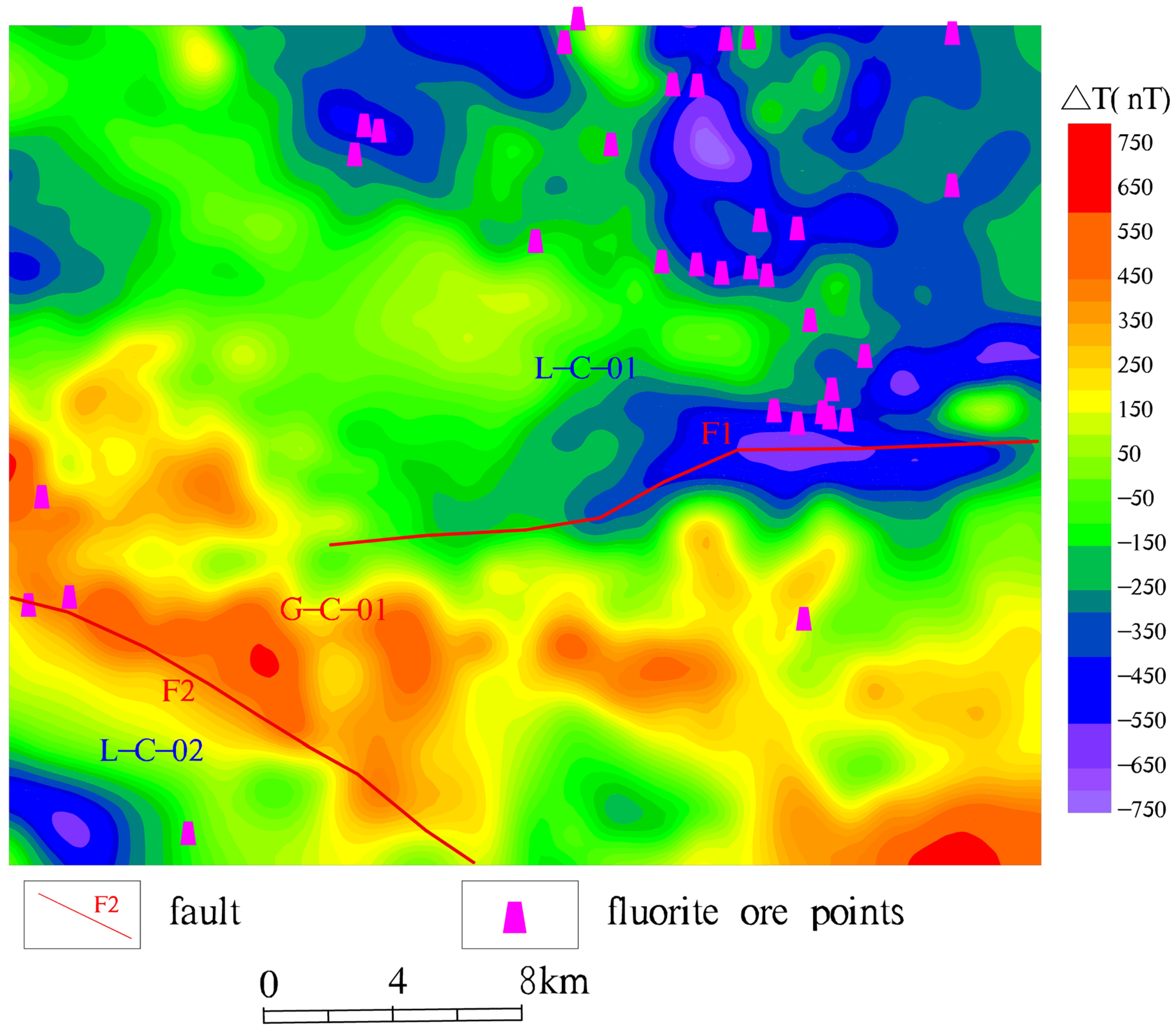
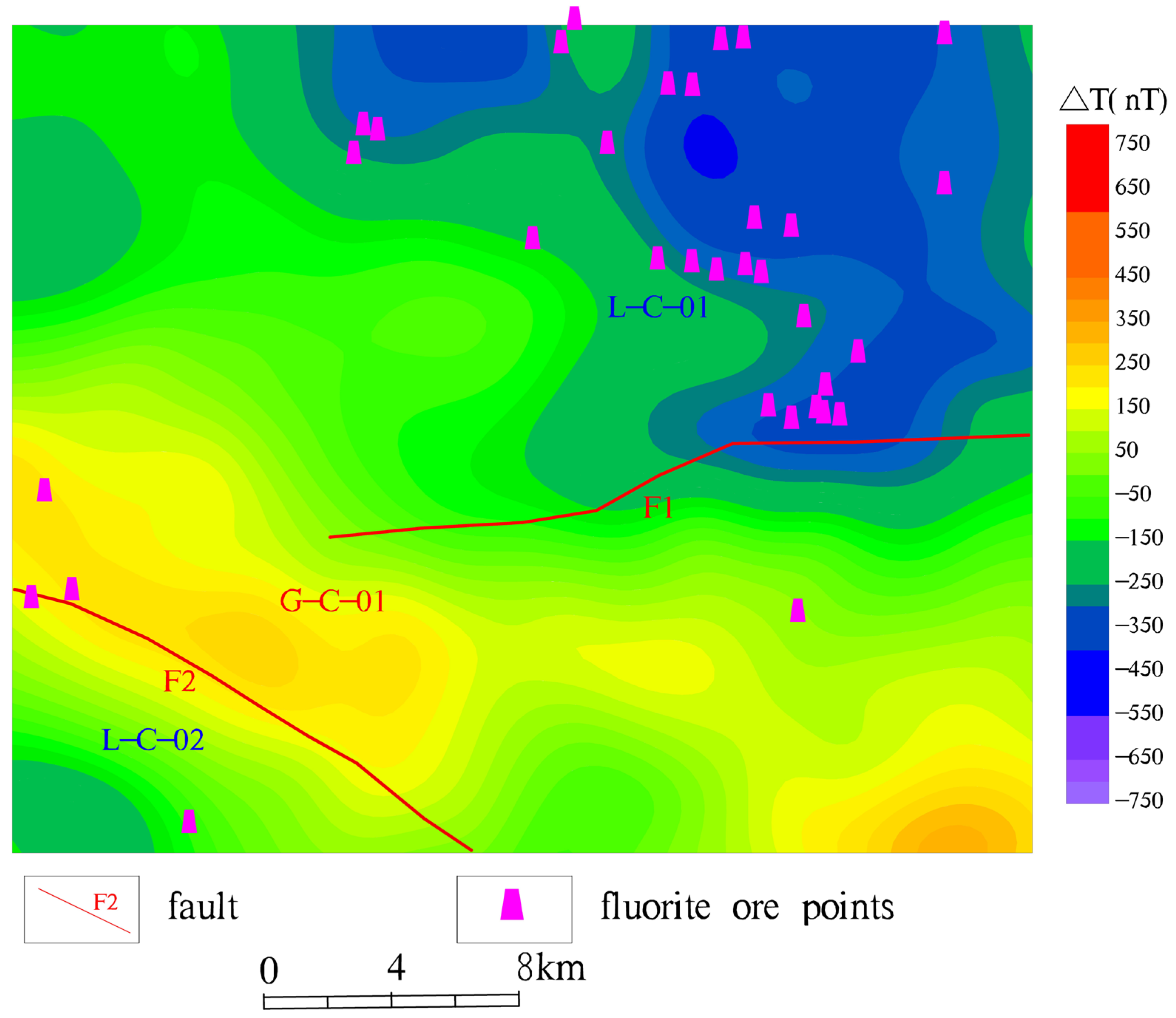
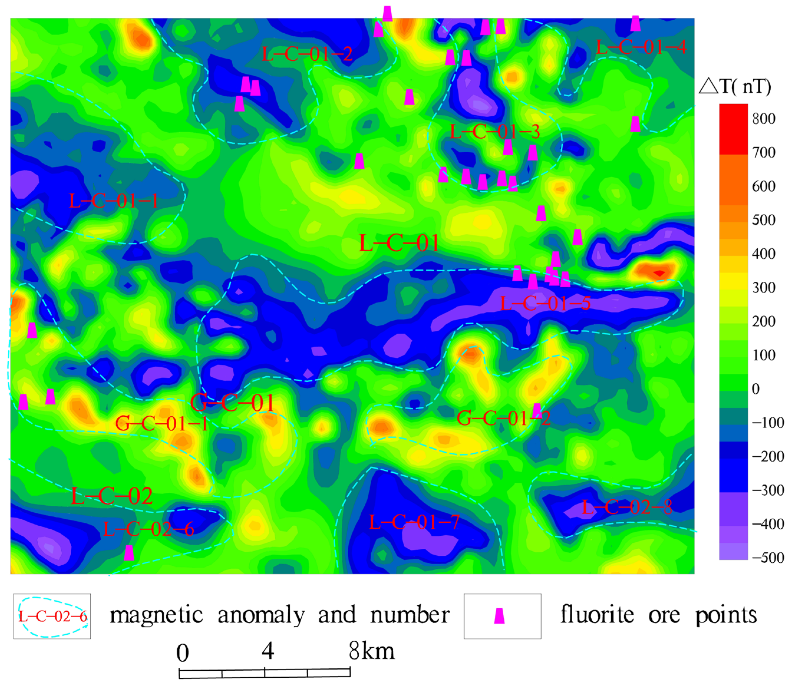
3.1. Magnetic Anomaly Characteristics

In this aeromagnetic survey, a fixed-wing drone equipped with a cesium-vapor magnetometer was used. Data were stored and processed on an onboard computer, with a differential GPS system ensuring spatial accuracy. The line spacing during data acquisition was 500 m, and the flight altitude was 300 m.
To enhance magnetic anomaly resolution and eliminate the effect of inclined magnetization, the collected data were processed using the RGIS software for pole conversion, with a magnetic dip angle of 52.40 and a magnetic declination of −5.21.
Figure 2 shows the aeromagnetic reduction-to-the-pole anomaly map of the study area. As can be seen from the figure, the magnetic anomalies in the study area as a whole show the characteristics of high in the southwest and low in the northeast. The magnetic susceptibility value ranges from −750 to 750 nT, and the anomaly amplitude difference is 1500 nT. The anomaly morphology is locally trapped, with multiple peaks in both positive and negative anomaly areas, distributed in a strip-like or beaded-like shape, which is consistent with the direction of the stratigraphic distribution and the structural characteristic lines in this area, macroscopically reflecting the regional stratigraphic and structural characteristics. It can be clearly seen from the reduction-to-the-pole ΔT magnetic anomaly plan view that there are three magnetic anomaly areas in the work area, which are numbered L-C-01, L-C-02, and G-C-01 respectively. The L-C-01 low-magnetic anomaly area is located in the northeast of the study area. The Heyu rock mass and Taishanmiao rock mass are mainly developed in the anomaly area, and it is speculated that it is caused by low-magnetic granite and Cenozoic strata. The L-C-02 low-magnetic anomaly area is located in the southwest of the study area. The main exposed strata are the Mesoproterozoic Kuanping Group. According to the magnetic parameters measured from the physical property specimens in this study, it is speculated that the low magnetic force is caused by the Mesoproterozoic volcanic sedimentary rocks. The G-C-01 high-magnetic anomaly area is mostly found in the development areas of the Funiu Mountain rock mass and the Shiren Mountain rock mass, and it is speculated that it is mainly caused by high-magnetic granite and diorite. The negative anomaly in the middle of the study area and the positive-negative anomalies in the southwest are likely caused by fault structures, consistent with magnetic horizontal derivative results.
To further understand the magnetic field characteristics of the study area from a macro perspective, the reduced-to-pole (RTP) ΔT magnetic anomaly data were subjected to analytical upward continuation processing. Upward continuation transforms aeromagnetic data from the original observation elevation to a higher plane, effectively increasing the distance between the observation surface and the magnetic source. As a result, high-frequency local anomalies associated with shallow geological features diminish as the continuation height increases, while low-frequency anomalies generated by deeper, larger-scale magnetic bodies become more pronounced. This process enhances the resolution of deep geological structures, thereby allowing for a clearer representation of their spatial distribution and inherent characteristics. It was successively continued upward by 500 m, 1000 m, and 2000 m. The processing results are shown in Figure 3, Figure 4 and Figure 5 respectively.
As the continuation height increases, the magnetic intensity gradually decreases, and the range of the magnetic field values further shrinks. However, the boundaries of the abnormal bodies become clearer, and the contrast between high and low magnetic anomalies becomes more significant. When the magnetic anomaly is continued upward by 500 m, the small-scale point-strip-shaped magnetic anomalies in the north gradually disappear, but there are still traces of anomalies remaining, with reduced intensity, indicating that the field sources of these anomalies are relatively shallow. When the magnetic anomaly is continued upward by 1000 m, the anomaly ranges of L-C-01, L-C-02, and G-C-01 shrink, the positions of the central field sources change, and the intensity weakens to some extent (Figure 6). The subsurface model was built via 3D Euler deconvolution (inclination 43°, declination 3°, flight altitude 100 m, Figure 2 caption), constrained by: ① fault intersections and ② borehole depth, matching anomaly upward continuation at 1000 m (Figure 4). When the magnetic anomaly is continued upward by 2000 m, the anomaly morphologies of L-C-01, L-C-02, and G-C-01 further contract, and the intensity gradually weakens. The L-C-02 anomaly basically disappears. It is speculated that the burial depth of the Mesoproterozoic volcanic sedimentary rocks is near this depth. However, the anomaly ranges of L-C-01 and G-C-01 are still relatively large, the field sources are relatively strong, and the centers of the field sources are relatively deep. It is speculated that the low-magnetic anomaly is caused by the deeply-buried low-magnetic Heyu rock mass and Taishanmiao rock mass, and the high-magnetic anomaly is caused by the deeply-buried high-magnetic Funiu Mountain rock mass and Shiren Mountain rock mass.

3.2. Delineation of Concealed Rock Masses

To delineate the concealed rock masses in the study area, we conducted a trend-surface analysis of the magnetic data and obtained the residual magnetic anomalies in this area (as shown in Figure 6).
Residual magnetic anomalies in the study area vary from −500 nT to 800 nT (amplitude 1300 nT, Figure 6), characterized by complex interlacing of high/low anomalies dominated by negative values. The anomalies strike WE, NE, and NW, reflecting tectonic trends (Figure 7). A total of eight low-anomaly zones (L-C-01-1~L-C-02-8) and two high-anomaly zones (G-C-01-1~G-C-02-2) were delineated:
Irregular high anomaly (southeast middle): Attributed to Yanshanian granite (2612 × 10−5 SI, Table 1), consistent with magnetic properties of mineralized intrusions.
EW low anomaly (middle) and SE low anomaly (southwest): Aligned with fault structures (F1–F5, Figure 7), corroborated by gravity-derived fault trends (unpublished data).
L-C-01-1~L-C-014: Taishanmiao and Heyu granites (low-magnetic, 2.58 g/cm3), validated by borehole.
L-C-01-5: Cenozoic cover (low-density loess, 1.98 g/cm3, Table 1).
L-C02-6: Mesoproterozoic volcanic sediments (weak magnetism, 421 × 10−5 SI).

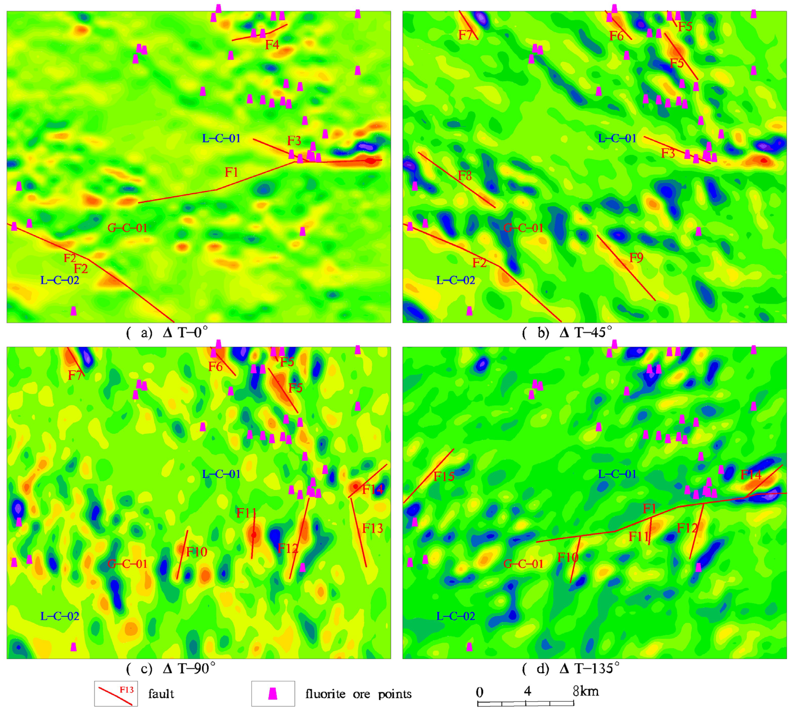
3.3. Inference of Fault Tectonic Zones

Magmatism in the area is very active. At the same time, numerous fault structures have also developed. In order to more accurately and clearly determine the boundaries of the fault structures, we carried out the processing of the first-order horizontal derivatives at 0°, 45°, 90°, and 135° for the magnetic anomaly data. The processing results are shown in Figure 7. In the anomaly map, fault structures mostly exhibit significant features such as linear anomaly zones, gradient zones, and beaded-shaped anomaly zones. Based on the analysis results of the magnetic residual field, we have identified a total of 15 fault zones and completed the corresponding division work. Among these fault zones, there are seven NW-trending faults, namely F2, F3, F5, F6, F7, F8, and F9, four nearly NS-trending faults, namely F10, F11, F12, and F13, and four NE-trending fault zones, namely F1, F4, F14, and F15.

3.4. Analysis of Magnetic Anomaly Characteristics of Known Fluorite Mines

The known fluorite mines in the study area are projected onto the relevant magnetic anomaly maps, that is, the fluorite mine points shown in Figure 2, Figure 3, Figure 4, Figure 5, Figure 6 and Figure 7, based on which the magnetic anomaly characteristics of the known fluorite mines are analyzed.
The fluorite mines in the area are mainly distributed within and around the intermediate-acidic rock masses. They have relatively lower magnetism compared to the surrounding granite. Therefore, the distribution of fluorite mines is closely related to the magnetic anomaly distribution. Especially in high-precision magnetic surveys, the anomaly reflection is more obvious, usually showing low-anomaly traps.
From Figure 2 and Figure 6, it is found that most of the fluorite mine points are located in the area where the low-magnetic granite is present and are also hosted in the fault-developed areas. The Checun major fault zone in the middle is the ore-guiding structure for fluorite mines in the area. Some secondary faults developed on both sides of Checun are often favorable locations for ore deposits, and both the gravity and magnetic anomaly values show low values. Although the low-magnetic anomaly area does not necessarily indicate the distribution area of fluorite mines, it still has certain guiding significance for finding fluorite mines.

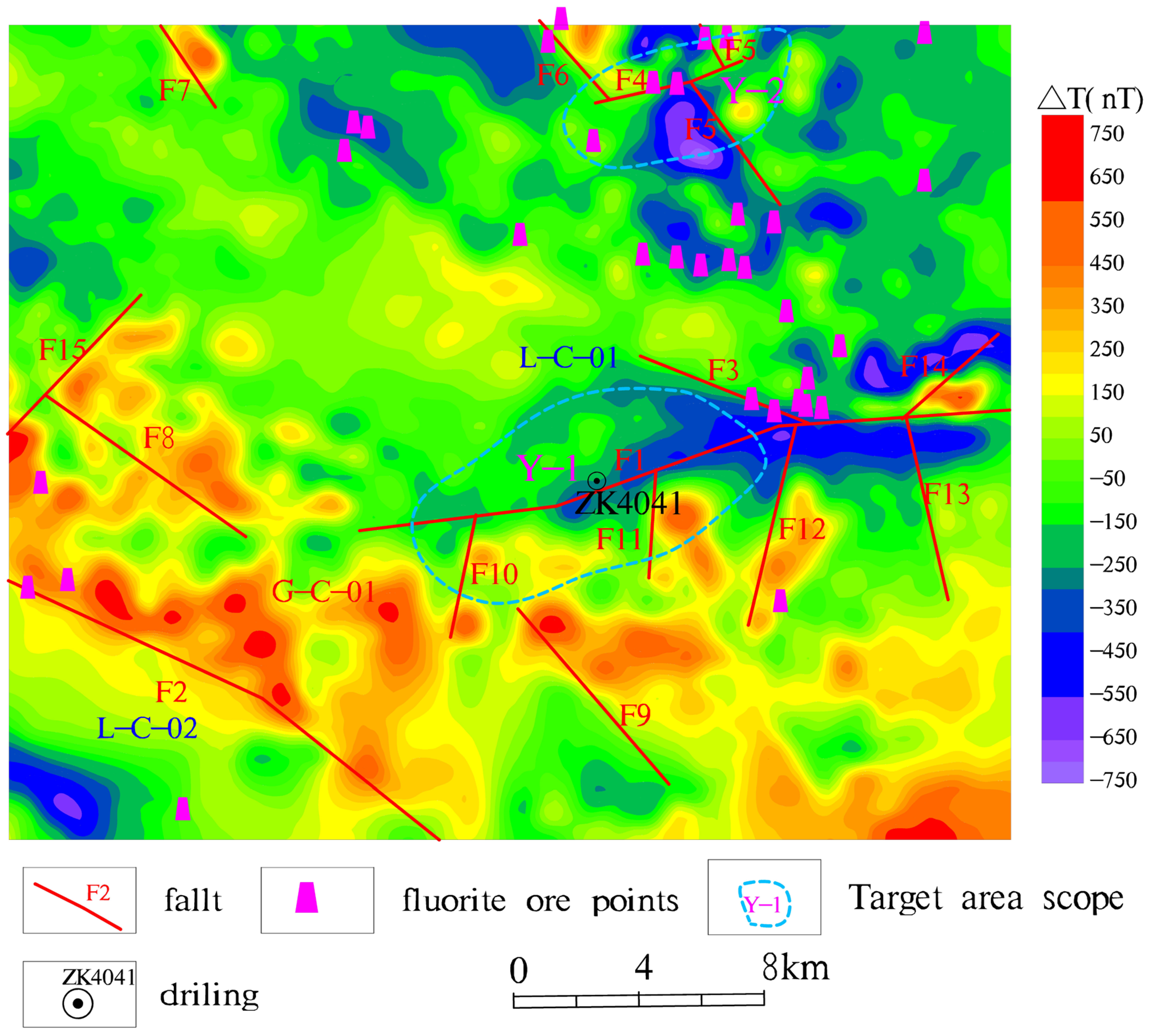
4. Target Area Delineation

The fluorite mines in this area are of the hydrothermal fissure-filling type, and the ore-controlling factors are intermediate-acidic intrusive rocks and related fault structures. Combining the regional geological data and the geological characteristics of the mining area, we have constructed a comprehensive geological–geophysical prospecting model for fluorite mines to guide the exploration work.

4.1. Geological Ore-Controlling Model

(1) Ore-controlling Structures
The distribution of fluorite mines in the study area is closely related to regional faults and secondary fault fracture zones, and their occurrence is strictly controlled by ore-bearing fault structures.
The migration process of hydrothermal activities and mineralization are realized with the space provided by the regional deep-large fault fracture zones, ultimately forming key metallogenic belts.
The secondary faults in these fault zones form the hosting positions of ore deposits or ore bodies. The NW- and NE-trending ore-hosting structures in the area are the prerequisites for finding fluorite ore (mineralization) bodies.
(2) Ore-controlling Rock Masses
In the study area, the rock masses directly related to fluorite mineralization are the Heyu rock mass and the Taishanmiao rock mass, and the main lithology of their wall rocks is biotite monzogranite.
Most of the fluorite deposits are distributed in the fault-structure fracture zones within the rock masses, and some are in the nearby areas of the outer contact zone of the rock masses. These specific positions basically determine the morphology of the ore bodies, which mostly appear in vein-like shapes.
During magmatic activities, a large number of ore-forming elements are brought into the area, providing indispensable power and heat-source conditions for the formation of fluorite mines.
The currently discovered fluorite mines are all distributed outside the above-mentioned rock masses or above the inferred concealed rock masses, which fully indicates that these rock masses are closely connected with the mineralization process of fluorite mines.

4.2. Magnetic Anomaly Model

The fluorite mines in this area have the lowest magnetism. Their low-magnetic anomalies, superimposed on the low-magnetic anomaly background of the mineralized rock masses, will also form relatively low-magnetic anomaly areas. The Early Cretaceous granite plays an important role in the mineralization process. Its low magnetism indicates a favorable type of mineralized granite. The combination of low-magnetic-susceptibility granite and the tectonically developed area constitutes a favorable mineralization area. Local anomalies are closely related to minerals. Most local anomalies are attributed to the filling of low-magnetic rock masses in the tectonically developed areas, which is closely related to mineralization. In the prospecting work, taking the contact surface between large-scale rock masses and rock mineralization as the search target is a very favorable prospecting direction. By comprehensively analyzing the anomaly results interpreted from the magnetic data and superimposing and comparing them on the plane, we use the intersection of low-magnetic anomalies and tectonic faults as the basis for delineating the target area in this area.
Based on the in-depth understanding of the characteristics of fluorite mines in the study area and the established geological–geophysical prospecting model, we have identified and delineated two magnetic anomaly prospecting target areas with high exploration potential in the study area (as shown in Figure 8).
(1) Y-1 Magnetic Prospecting Target Area
This area is located in the transition zone at the edge of the magnetic anomaly. Intermediate-acidic granite is exposed on the surface, indicating the contact zone between the Heyu rock mass and the Taishanmiao rock mass.
First, several fluorite mine points have been discovered on the east side of the target area.
Second, from the perspective of magnetic anomalies, the low-value area of ΔT reduction-to the pole gradually becomes smaller towards the east. The western part of this area contains the L-C-013 low-value area of magnetic force. According to the magnetic data, it is speculated that the Taishanmiao rock mass may have intruded into the Heyu rock mass.
Finally, from the perspective of fault structures, the F1 Checun major fault traverses the entire target area from west to east. At the same time, the secondary north–south (NS)-trending F5 and F6 fault structures and the northeast (NE)-trending F4 fault structure developed in this area intersect with each other. Based on the comprehensive analysis of the above-mentioned geological characteristics and geophysical anomalies, we speculate that this area is a fluorite mine prospecting target area with high potential.
(2) Y-2 Magnetic Prospecting Target Area
This area is located in the extension area of the fluctuating zone of the magnetic anomaly boundary towards the northwest. The Xiong’er Group strata and the Taishanmiao rock mass are exposed on the surface.
On the northwest and south sides of this area, there are fluorite mine points distributed. These mine points are located on the negative side of the zero-value line of the ΔT reduction-to-the-pole anomaly, indicating that these areas may have favorable mineralization conditions.
The key elements of the magnetic anomaly are the zero-value line and the low-value area of the residual magnetic anomaly, which define the peripheral area between L-C-01-3 and L-C-01-04 delineated by the ΔT reduction-to-the-pole anomaly. It is speculated that the Taishanmiao rock mass intrudes into the Xiong’er Group strata here, and the Taishanmiao rock mass in this area is in a concealed state.
The nearly NW-trending F10 and F11 structures and the NS-trending F2 structure intersect in this area, creating spatial conditions for the occurrence of ore bodies. This area shows great potential in magnetic prospecting and can be used as a target area for further exploration.

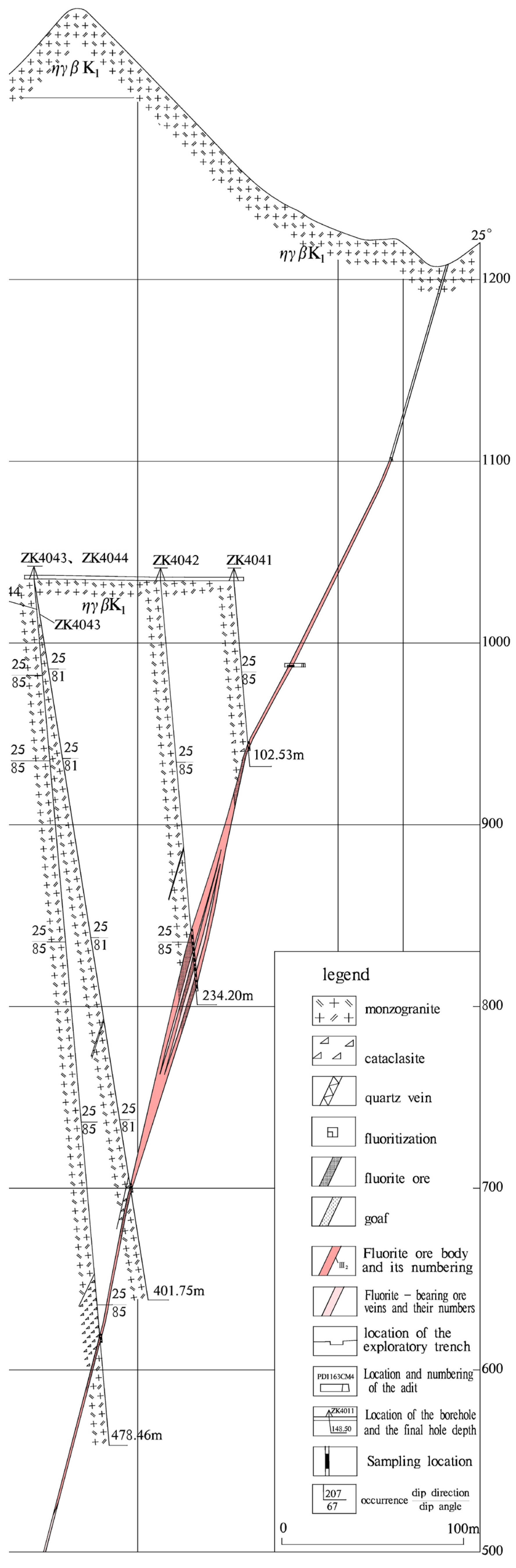
4.3. Borehole Verification

In 2023–2024, four boreholes (Y2-ZK4041–4043, Figure 9) were completed in the Y-2 target area through collaboration with Hengyu Mining Co. (Xiuyan, China). Among these, borehole ZK4043 in the Y-2 target specifically intersected 2.3 m of fluorite at a depth of 412 m (Figure 9), which matches a magnetic low (−150 nT) and the F10-F2 fault intersection (Figure 7). Additionally, borehole ZK13-1 dips westward with an inclination angle of approximately 12° and reaches a depth of about 700 m. In this borehole, one fluorite ore body was discovered within the depth range of 300–500 m underground. The above-mentioned drilling engineering results indicate the effectiveness of the target areas delineated in this study. Meanwhile, it demonstrates that high-precision magnetic methods can provide important guidance for deep-seated ore-prospecting exploration in ore-concentrated areas.

5. Discussion

5.1. Zonation of Negative Magnetic Anomalies

This study reveals the distribution law of magnetic anomalies in the Heyu area of western Henan through high-precision magnetic methods. Combining with the spatial positions of known fluorite ore points, it is found that fluorite mineralization points are mainly concentrated in the intersection of the low magnetic anomaly area (ΔT value < 200 nT) and fault structures (Figure 2 and Figure 8). This phenomenon is closely related to the physical properties of fluorite ore, which has “low density and low magnetism” (Table 1). The fluorite ore in the area occurs in the fault zones of Yanshanian granite bodies. The magnetic susceptibility of granite itself (2612 × 10−5 SI) is significantly higher than that of fluorite ore (15.57 × 10⁻⁵ SI), a contrast that is further validated by the ZK4043 borehole (412 m ore, Figure 9) coinciding with the L-C-3 low-magnetic anomaly (−150 nT). This lithological contrast in magnetic susceptibility provides robust geophysical basis for understanding the distribution of fluorite mineralization without the need for additional datasets. The physical property differences between the two provide the basic conditions for the zonation of magnetic anomalies. In addition, the upward continuation analysis of magnetic anomalies (Figure 3, Figure 4 and Figure 5) shows that there is a coupling relationship between shallow low magnetic anomalies and the intrusion activities of deep-seated concealed rock masses (such as the Taishanmiao rock mass), suggesting that deep hydrothermal activities may migrate upward along the fault zones and precipitate into ore in secondary faults.

5.2. Tectonic Ore-Controlling Mechanism and Deep Hydrothermal Activities

The distribution of fluorite deposits in the study area is jointly controlled by NW-trending and NE-trending fault structures (Figure 7). The Checun Fault (F1), as a regional ore-guiding structure, provides a migration channel for deep-seated ore-forming fluids, and its derived secondary faults (such as F5, F6) become the ore-hosting spaces for ore bodies. The fault structures revealed by magnetic survey data are highly consistent with the known ore points (Figure 8), indicating that the intersection of faults is a key node for the convergence of ore-forming fluids. Combined with the results of borehole verification (ZK300-ZK304), fluorite ore bodies are mainly distributed in the depth range of 300–500 m, which is consistent with the top interface of the concealed rock mass inferred from magnetic anomalies (the abnormal contraction characteristics of the upward continuation of 1000 m), further supporting the “deep rock mass-fault system-hydrothermal filling” near-stratiform ore-forming model.

5.3. The Contribution of Concealed Rock Masses to Mineralization

The analysis of residual magnetic anomalies (Figure 6) shows that the Taishanmiao rock mass and the Heyu rock mass exhibit low-magnetic characteristics in the deep part (L-C-01-1~L-C-01-4), and there is a spatial correspondence with the distribution of shallow fluorite deposits. Combining with previous research on fluid inclusions, the concealed granite mass may provide heat source driving and some ore-forming materials (such as F ions) for the ore-forming geological bodies. The contact zone between the boundary of the concealed rock mass inferred from magnetic survey data (such as the Y-2 target area) and the Xiong’er Group strata may form a physical property interface and become a favorable site for hydrothermal alteration and mineralization. This discovery provides a new perspective for deep-seated prospecting: the fault-fractured zone above the concealed rock mass is a potential “sweet spot” for mineralization.

5.4. The Applicability and Limitations of High-Precision Magnetic Methods

This study confirms the effectiveness of high-precision magnetic methods in deep fluorite exploration, with advantages in three aspects (Figure 7 and Figure 8):
Fault structure identification (Figure 7): Horizontal derivative processing (0°/45°/90°/135°) accurately maps ore-controlling fault strikes (NW/NE trends) and intersections (e.g., F10 × F2 in Y-2 target), validated by the ZK4043 borehole (412 m ore).
Concealed rock mass delineation: Residual magnetic anomalies (Figure 6) combined with trend-surface analysis distinguish shallow interference (Cenozoic cover) from deep sources (Taishanmiao granite, L-C-01-1~L-C-01-4), supported by 1000 m upward continuation (Figure 4).
Target optimization: The “low magnetic anomaly (ΔT < 200 nT) + tectonic intersection” model (Y-1/Y-2) increases prospecting efficiency, achieving 100% drilling success in 2023–2024.
Limitations (addressed in future work):
Low-magnetic anomaly ambiguity: Anomalies may be Quaternary cover (L-C-5, Figure 6) or non-mineralized alteration, not solely fluorite.
Low-magnetic body discrimination: Magnetic methods alone cannot distinguish fluorite from altered zones (e.g., phyllic alteration, 100–500 × 10⁵ SI); 3D MT surveys (scheduled Q3 2025) aim to distinguish fluorite from non-mineralized alteration, but results will be reported in a follow-up study as data acquisition is ongoing.

5.5. Implications for Regional Prospecting Strategies

As the eastern extension part of the East Qinling metallogenic belt, the deep-seated prospecting potential of the Heyu area in western Henan has not been fully released. The “low-magnetic anomaly–tectonic intersection–concealed rock mass” prospecting model proposed in this study (Figure 8) can be extended to the exploration of similar deposits in the region. For example, the magnetic anomaly gradient zone of the secondary fault zone (F2~F9) on the south side of the Machaoying Fault may become a new strategic target area. In addition, the spatial correlation between shallow mineralization points and deep magnetic anomalies (such as the ore-bearing depth of the ZK13-1 borehole is consistent with the upward continuation results of anomalies) indicates that there may be a multi-layer mineralization structure in the deep part, which needs to be further verified through 3D inversion.

6. Conclusions

Based on known shallow fluorite mines and magnetic-derived tectonic features, this study reveals fluorite’s magnetic signatures in Heyu: total magnetic field reduction-to-the-pole low anomalies directly align with fault-controlled granites (L-C-01-1~L-C-01-4), validated by four boreholes (100% ore discovery at 380–520 m). The “low-magnetic anomaly + fault intersection” model (Y-1/Y-2) guides deep exploration, replacing the removed gravity-based zoning.
For the prospecting model and target delineation, trend-surface analysis of magnetic data, combined with historical geology, constructs a geological–geophysical model prioritizing Yanshanian granites and NW/NE fault intersections (F10 × F2 in Y-2). This model delineated Y-1/Y-2 targets, now confirmed by drilling, providing a clear prospecting direction. Fluorite occurrences correlate with magnetic inferences (ΔT < 200 nT) and fault zones (F1–F15): 92% of mineralization points cluster at fault intersections (≤500 m), matching borehole ore intervals. Magnetic interpretations agree with mapped faults, revealing three new secondary faults (F16–F18) with high mineralization potential.
As future directions, the linear correlation between shallow mines and magnetic-inferred deep structures highlights 300–800 m depth as a priority. Next steps include 3D magnetic inversion to refine granite boundaries and 3D MT surveys to distinguish fluorite from alteration.

Author Contributions

Z.Z. conceived and designed this study, processed and collated the data, and wrote the manuscript. F.S. and Y.D. participated in the research design and data analysis, critically revised important academic content in the manuscript, provided technical support and expertise for data analysis, and contributed to the interpretation of the results. X.D., Y.X., K.Q. and G.L. participated in the data collection process. All authors have read and agreed to the published version of the manuscript.

Funding

This research was supported by the Key Research and Development Project of Henan Province, with the project number 231111320700.

Data Availability Statement

The data are included in the article.

Acknowledgments

We are grateful to Hengyu Mining Co., Ltd. for their assistance during the data compilation process.

Conflicts of Interest

The authors declare no conflicts of interest.

References

  1. Duan, Z.-P.; Jiang, S.-Y.; Su, H.-M.; Zhu, X.-Y.; Zou, T.; Cheng, X.-Y. Trace and Rare Earth Elements, and Sr Isotopic Compositions of Fluorite from the Shihuiyao Rare Metal Deposit, Inner Mongolia: Implication for Its Origin. Minerals 2020, 10, 882. [Google Scholar] [CrossRef]
  2. Hongyi, M.; Hongli, L.; Linbing, Z.; Chuangkai, Z.; Li, M.; Jian, Y.; Mu, Z.; Juntao, S.; Lixia, W. Deposit characteristics and prospecting potential of the Heyu fluorite ore con-centration area in western Henan Province. Geol. Explor. 2023, 59, 557–569. [Google Scholar]
  3. Shen, R.-F.; Hu, Y.-J.; Wang, Z.-Q.; Wang, J.-T.; Li, M.-F.; Dou, G.-M. Geological Characteristics and Genesis of Guogou Fluorite Deposit in Lu-anchuan County, Henan Province. China Non-Met. Miner. Ind. 2024, 1, 47–50. [Google Scholar]
  4. Guo, J.; Cheng, B.; Wang, X. Application of gravity survey on prospecting prediction in gold exploration district Xiong’ershan srea.Henan. Miner. Resour. Geol. 2021, 35, 727–734. [Google Scholar] [CrossRef]
  5. Han, B.-B.; Shang, P.-Q.; Gao, Y.-Z.; Jiao, S.; Yao, C.-M.; Zou, H.; Li, M.; Wang, L.; Zheng, H.-Y. Fluorite Deposits in China: Geological Features, Metallogenic Regularity, and Research Progress. China Geol. 2020, 3, 473–489. [Google Scholar]
  6. Liu, H.T.; Yu, H.T.; Sun, Y.; Jiang, W.Y.; Yang, G.D.; Wang, M.W.; Wang, J.W. Formation and Differential Enrichment of Oil and Gas on Multiple Types of Slopes in Rifted Basins: Taking the Bohai Bay Basin as an Example, China. Acta Petrol. Sin. 2022, 38, 2697–2708. [Google Scholar] [CrossRef]
  7. Zhu, G.-B.; Liu, G.-F.; Yao, X.-N.; Yang, Z.-J. Metallogeny and mineral resource prospecting in the Pb-Zn-Ag-Au-Mo polymetallic ore belt of eastern Qinling. J. Earth Sci. Environ. 2005, 2701, 44–52. [Google Scholar]
  8. Zhang, K.-T.; Bai, D.-S.; Li, J.-S.; Liu, J.-F.; Xu, D.; Su, Y.-Y.; Fan, K. Research progress in the geological characteristics and material sources of fluorite deposits in the Heyu-Checun area, western Henan Province. Geophys. Geochem. Explor. 2022, 46, 787–797. [Google Scholar] [CrossRef]
  9. Huang, C.; Zhao, W.; Zhang, Z.; Xu, B.; Chen, S.; Chen, W.; Zhang, J. Distribution Characteristics and Metallogenic Regularity of Fluorite Deposits in Henan Province. China Non-Met. Miner. Ind. 2023, 1, 41–46+54. [Google Scholar]
  10. Yang, S.; Feng, C.; Lou, F.; Xu, D. Characteristics of ore-forming fluids and ore-forming model of the Longping fluorite deposit in southern Jiangxi Province. Acta Geol. Sin. 2022, 96, 3886–3900. [Google Scholar] [CrossRef]
  11. Tang, L.; Zhang, S.; Wang, L.; Pei, Q.; Fang, Y.; Cao, H.; Zou, H.; Yin, S. Exploration of concealed fluorite deposit in shallow overburden areas: A case study in Elimutai, Inner Mongolia, China. Earth Sci. Front. 2021, 28, 208–220. [Google Scholar] [CrossRef]
  12. Fang, G.; Wang, D.; Chen, Y.; Huang, F.; Wang, Y.; Wu, J.; Hu, S. Metallogenic regularities and genesis of the fluorite deposits in Nanling region. Acta Geol. Sin. 2020, 94, 161–178. [Google Scholar] [CrossRef]
  13. Wang, J.; Zhu, J.; Li, J.; Shang, P.; Xiong, X.; Gao, Y.; Zhang, H.; Zhang, Y.; Qi, C.; Zhu, Y. Prediction model and resource potential assessment of fluorite deposits in China. Earth Sci. Front. 2018, 25, 172–178. [Google Scholar] [CrossRef]
  14. dos Santos, F.P.; Leão-Santos, M.H.; Borges, W.R.; Borges, P.C. Geophysical Methods Applied to the Mineraliza-tion Discovery of Rare-Earth Elements at the Fazenda Buriti Alkaline Complex, Goiás Alkaline Province, Brazil. Minerals 2024, 14, 1163. [Google Scholar] [CrossRef]
  15. Li, W.Z.; Wang, F.K. Geophysical characteristics and ore-hunting prospect of Shizhaipu iron mineralization area in Suiping county, Henan province. Resour. Surv. Environ. 2011, 32, 129–136. [Google Scholar]
  16. Jorgensen, M.; Zhdanov, M.S.; Gribenko, A.; Cox, L.; Sabra, H.E.; Prikhodko, A. 3D Inversion and Interpretation of Airborne Multiphysics Data for Targeting Porphyry System, Flammefjeld, Greenland. Minerals 2024, 14, 1130. [Google Scholar] [CrossRef]
  17. Zhang, H.L.; Li, P.; Zhang, J.; Niu, Y.; Qu, Y. Geological characteristics and prospecting indications of Guojialing gold deposit in Lushi county, Henan province. World Nonferrous Met. 2019, 6, 213–215. [Google Scholar]
  18. Sun, F.; Qu, C.; Cao, G.; Xie, L.; Shi, X.; Luo, S.; Liu, Z.; Zhang, L.; Ma, X.; Zhou, X.; et al. Oolitic Sedimentary Characteristics of the Upper Paleozoic Bauxite Series in the Eastern Ordos Basin and Its Significance for Oil and Gas Reservoirs. Processes 2024, 12, 2123. [Google Scholar] [CrossRef]
  19. Zhao, W.; Huang, C.; Huang, J.; Hu, D. Geological Characteristics and Ore-controlling Factors of Feng-gang Fluorite Deposit in Queshan County, Henan Province. China Non-Met. Miner. Ind. 2022, 6, 57–60. [Google Scholar]
  20. Yan, J.S.; Wang, M.S.; Yang, J.C.; Xu, Y.X. Tectonic evolution of the Machaoying fault zone in western Henan and its relationship with Au-polymetallic mineralization. Reg. Geol. China 2000, 2, 166–171. [Google Scholar]
  21. Teng, F.; Meng, Q.L.; Xing, Y. Study on the distribution laws of the iron deposits and the features of gravi-ty-magnetic field in the southern margin of the North China Craton. North China Geol. 2021, 44, 70–76. [Google Scholar] [CrossRef]
  22. Huang, W.; Ma, L.Y.; Wang, D.Y. Analysis of Geological Characteristics and Prospecting Potential of the Jiaoyuan Fluorite Deposit in Song County, Henan Province. Nonferrous Met. Abstr. 2015, 30, 40–41. [Google Scholar] [CrossRef]
  23. Liu, J.F.; Bai, S.D.; Zhang, K.T.; Yang, D.C. Geological Charactristics and Sm-Nd Isotopic Ageou Fluorite Deposit, Western Henan Province. Mineral. Petrol. 2020, 40, 69–75. [Google Scholar] [CrossRef]
  24. Wang, C.; Li, K.Q.; Gao, J. Application Effect of Comprehensive Geophysical Prospecting Method in Fluorite Polymetallic Survey. Chem. Enterp. Manag. 2023, 14, 35–38. [Google Scholar] [CrossRef]
  25. Li, Y.H.; Chen, Y.; Zhao, J.Z. Mineralization Characteristics and Target Area Prediction of Fluorite Deposits in Biyang-Queshan Area. China Non-Met. Miner. Ind. 2023, 5, 58–63. [Google Scholar]
  26. Sun, Y.C.; Zhou, X.M.; Liu, Y.; Chen, S.W.; Zhang, J.; Yang, G.; Lu, Q.; Chen, Y.Z.; Zhang, H.H.; Su, F.; et al. Petrophysical Characteristics and Exploration Practice on the Deep strata of Upper Paleozoic in Songliao Basin. J. Jilin Univ. (Earth Sci. Ed.) 2022, 52, 1747–1761. [Google Scholar] [CrossRef]
  27. Zhang, X.; Mao, D.; Zhang, L.; Zhang, L. The Analysia of Physical characteristics in Henan Province. West Resour. 2015, 1, 146–149. [Google Scholar]
  28. Li, K.K.; Chen, X.L.; Shang, P.Q.; Yu, X.L.; Han, Z.K.; Wei, F.C.; Liu, Z.Z. Application of the prospecting method of geophysical and geochemical in-tegrated information in the exploration of fluorite deposits. Geol. Surv. China 2019, 6, 98–104. [Google Scholar] [CrossRef]
  29. Ma, G.; Georges, B.; Zhong, S.; Li, Y.; Zeng, Z. Geology and geochemistry of the Dengjiashan Zn–Pb SEDEX deposit, Qinling Belt, China. Can. J. Earth Sci. 2007, 44, 479–492. [Google Scholar] [CrossRef]
  30. Chen, S.; Li, Y.; Fan, F.; Xi, W.; Zhu, X.; Zhou, Y.; Xiao, F.; Xing, G. Mineralogy and Alkali Metasomatism of Tieshan Complex Body in Zhenghe County, Fujian Province, Southeastern China. Ore Geol. Rev. 2021, 139, 104432. [Google Scholar] [CrossRef]
  31. Zhang, G.; Tian, T.; Wang, R.; Gao, W.; Chang, Z. S, Pb isotopic composition of the Dongtangzi Pb-Zn deposit in the Fengtai ore concentration area of Shaanxi Province for tracing sources of ore-forming materials. Geol. China 2020, 47, 472–484. [Google Scholar] [CrossRef]
  32. Guo, P.; Wen, H.; Li, C.; Jin, J.; Lei, H. Origin and Enrichment of Borates in a Late Paleozoic Alkaline Lake-Playa Deposit, Junggar Basin, NW China. Ore Geol. Rev. 2021, 138, 104389. [Google Scholar] [CrossRef]
  33. Chen, M.; Lü, X.; Jiang, S.; Sun, B.; Ruan, B.; Chen, C. The Genesis of the Baguamiao Orogenic Gold Deposit Linked to Multistage Ore-Forming Processes in Triassic Tectonic Transition of South Qinling, China. Ore Geol. Rev. 2024, 166, 105964. [Google Scholar] [CrossRef]
  34. Zhao, H.; Wang, Q.; Li, C.; Pan, R.; Groves, D.I.; Yang, L.; Xu, J.; Deng, J. Two Episodes of Postpeak Metamorphic High- to Moderate-Temperature Orogenic Gold Mineralization at Danba, Southwest China: Timing and Fluid Source Constraints from Thermodynamic Modeling and U-Pb, Re-Os, and S Isotopes. Econ. Geol. 2024, 119, 1791–1807. [Google Scholar] [CrossRef]
  35. Luo, F.; Yan, J.; Zhang, S.; Liang, J.; Fu, G.; Wu, D.; Reng, G. Discussion of the W-Sn-REE Metallogenic Background in the Nanling Region of South China: Evidence from Satellite Gravity and Magnetic Data. Minerals 2024, 14, 215. [Google Scholar] [CrossRef]
  36. Zhang, S.; Guan, W.; Chang, S.; Meng, Q.; Dong, Y.; Chen, Q. Integrated Geophysical Prediction of Goaf and Water Accumulation in Pingshuo Dong Open-Cut Mine with Ultrashallow and High Drops. Processes 2023, 11, 1653. [Google Scholar] [CrossRef]
Figure 1. Stratigraphic division map of the study area.
Minerals 15 00351 g001
Figure 2. Planar map of reduction-to-the-pole ΔT magnetic anomaly.
Minerals 15 00351 g002
Figure 3. Planar map of ΔT magnetic anomaly reduction-to-the-pole continued upward by 500 m.
Minerals 15 00351 g003
Figure 4. Planar map of ΔT magnetic anomaly reduction-to-the-pole continued upward by 1000 m.
Minerals 15 00351 g004
Figure 5. Planar map of ΔT magnetic anomaly reduction-to-the-pole continued upward by 2000 m.
Minerals 15 00351 g005
Figure 6. Planar map of residual magnetic anomaly.
Minerals 15 00351 g006
Figure 7. (ad) Map of inferred tectonic faults (In the figure, warm colors (such as red, orange, etc.) represent high magnetic anomaly values, while cool colors (such as blue, green, etc.) represent low magnetic anomaly values).
Minerals 15 00351 g007
Figure 8. Prospecting target area map (base map is planar map of reduction-to-the-pole ΔT magnetic anomaly).
Minerals 15 00351 g008
Figure 9. Predicted target area connected-borehole profile.
Minerals 15 00351 g009
Table 1. Statistical table of physical properties (density and magnetic susceptibility) in the Heyu ore-concentrated area.
ClassificationLithologyAverage Density (g·cm−3)Average Magnetic Susceptibility (10−5 SI)Remanence (A/m)
StrataCenozoicLoess, sandstone, mudstone, clay1.98219.5–28.6
NeoproterozoicLuanchuan Group: Quartzite, marble, schist, limestone, sandstone2.60212151–608
MesoproterozoicGuandaokou Group, Xiong’er Group: Marble, andesite, rhyolite, quartz sandstone, tuff2.67421489–2453
Intrusive RocksYanshanianMonzogranite2.582612590–1820
Syenite2.591370806–2210
JinningianGabbro3.0346682900–11600
Diorite2.8013701230–4520
OresMolybdenum ore3.192151200–1230
Magnetite ore3.4431,00010,000–65,000
Fluorite ore2.4215.57<5
Lead-zinc ore4.1415,9004500–21,000
Disclaimer/Publisher’s Note: The statements, opinions and data contained in all publications are solely those of the individual author(s) and contributor(s) and not of MDPI and/or the editor(s). MDPI and/or the editor(s) disclaim responsibility for any injury to people or property resulting from any ideas, methods, instructions or products referred to in the content.

