

The Uplift and Denudation History of the Jianfeng Pluton on Hainan Island, China
 ,
,
Abstract
1. Introduction
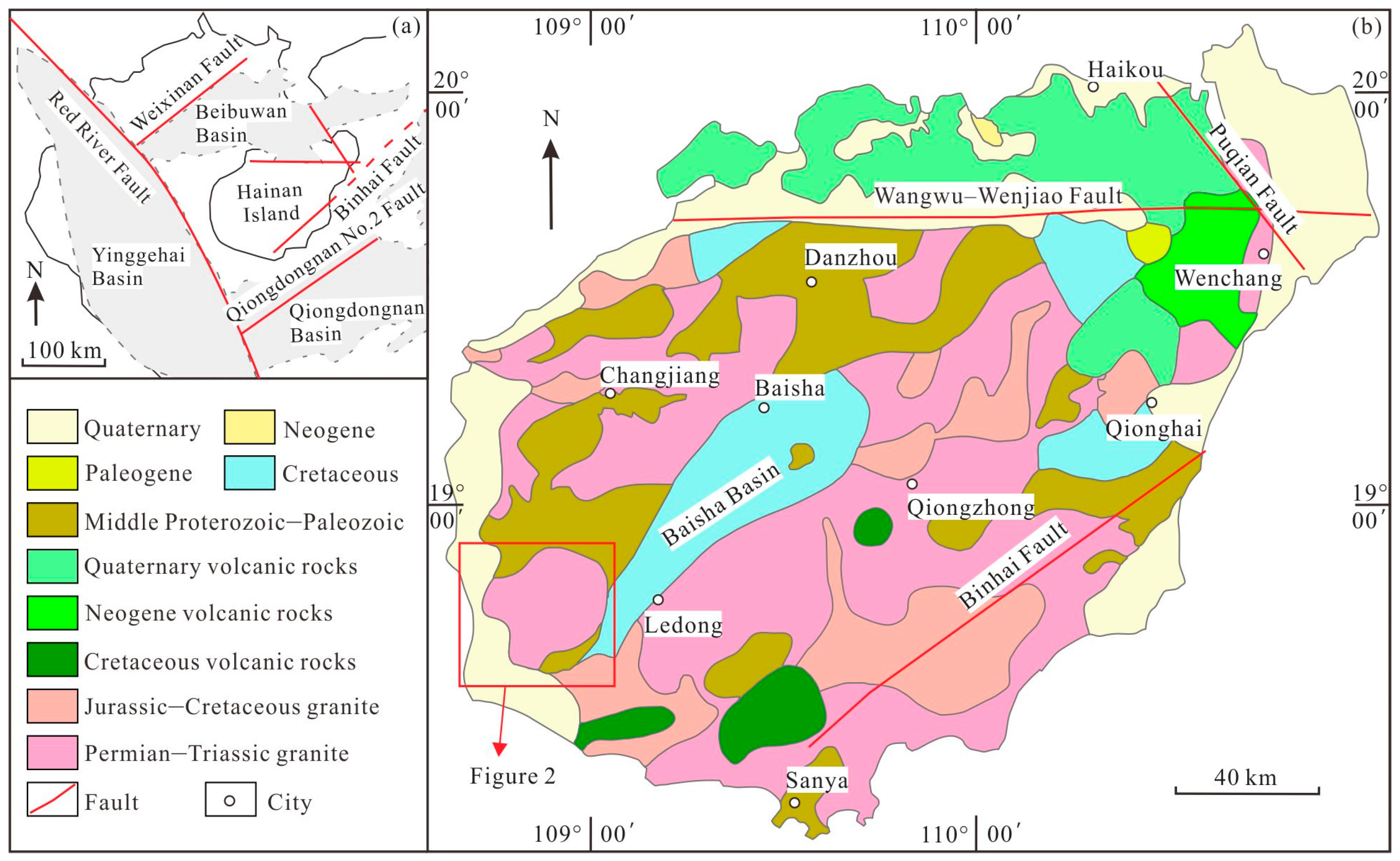
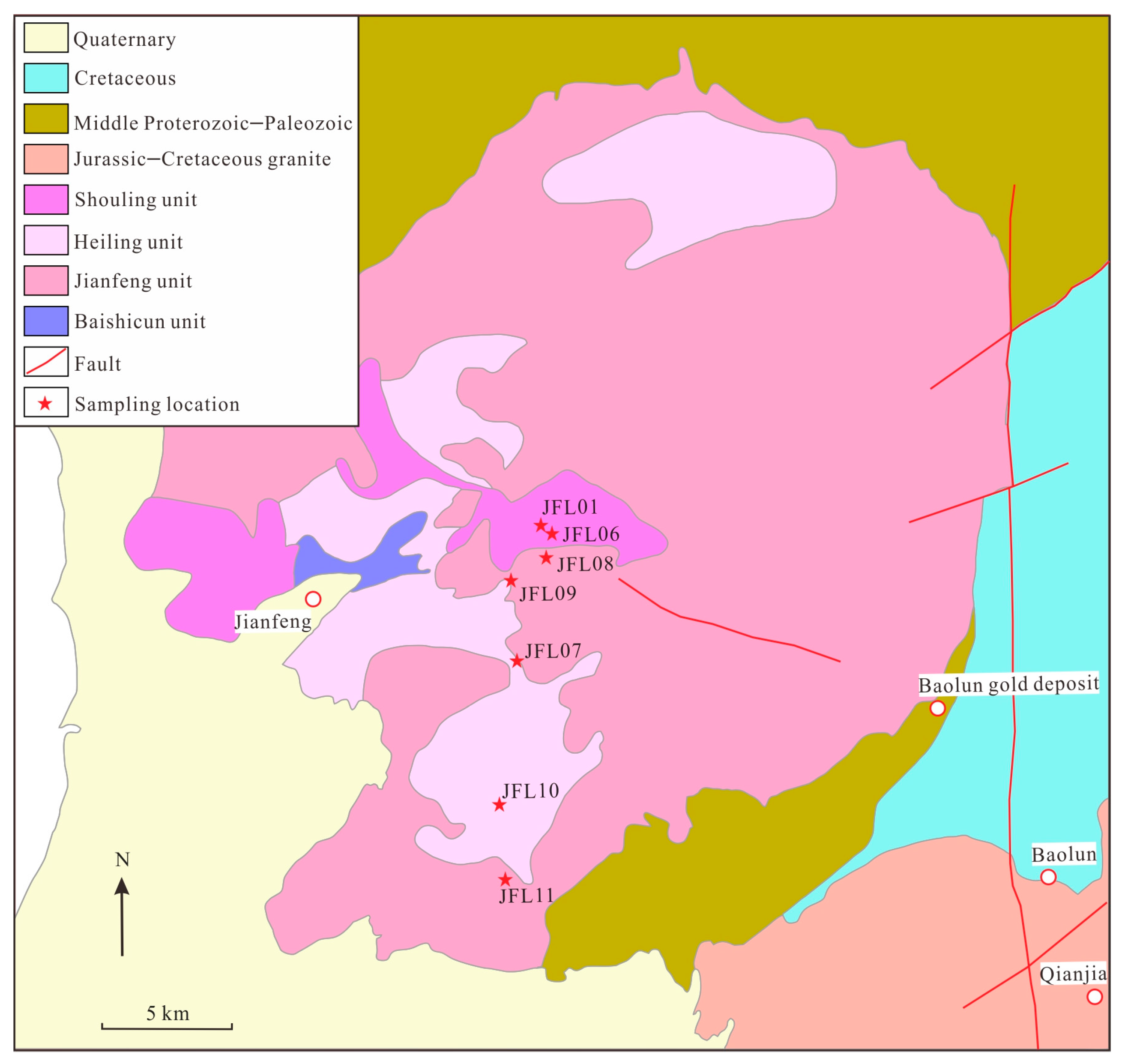
2. Geological Setting
3. Methods
4. Results
4.1. ZFT Results
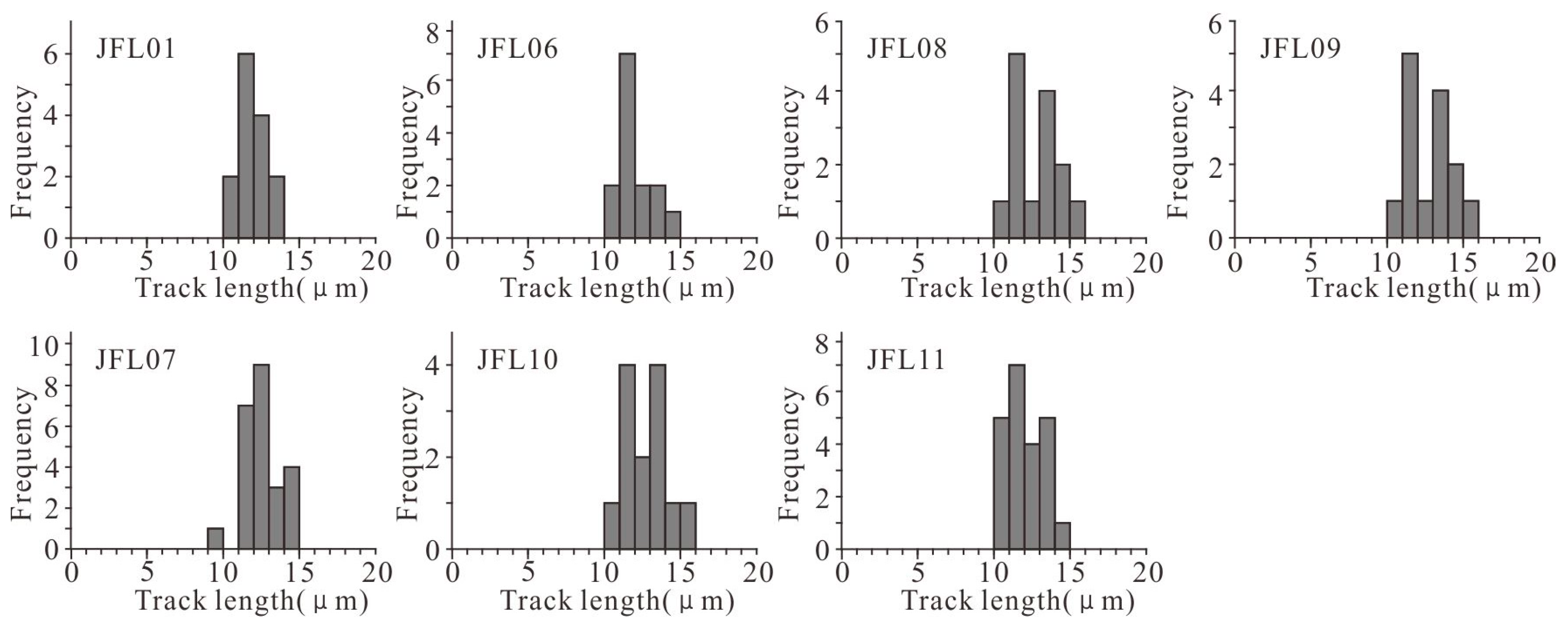
4.2. AFT Results
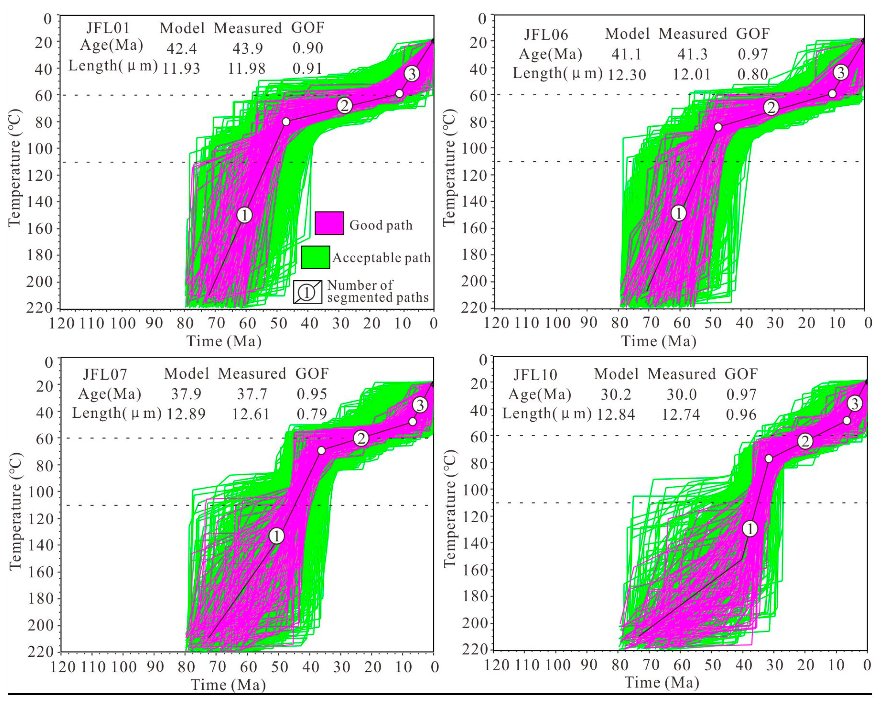
4.3. Modeling Results
5. Discussion
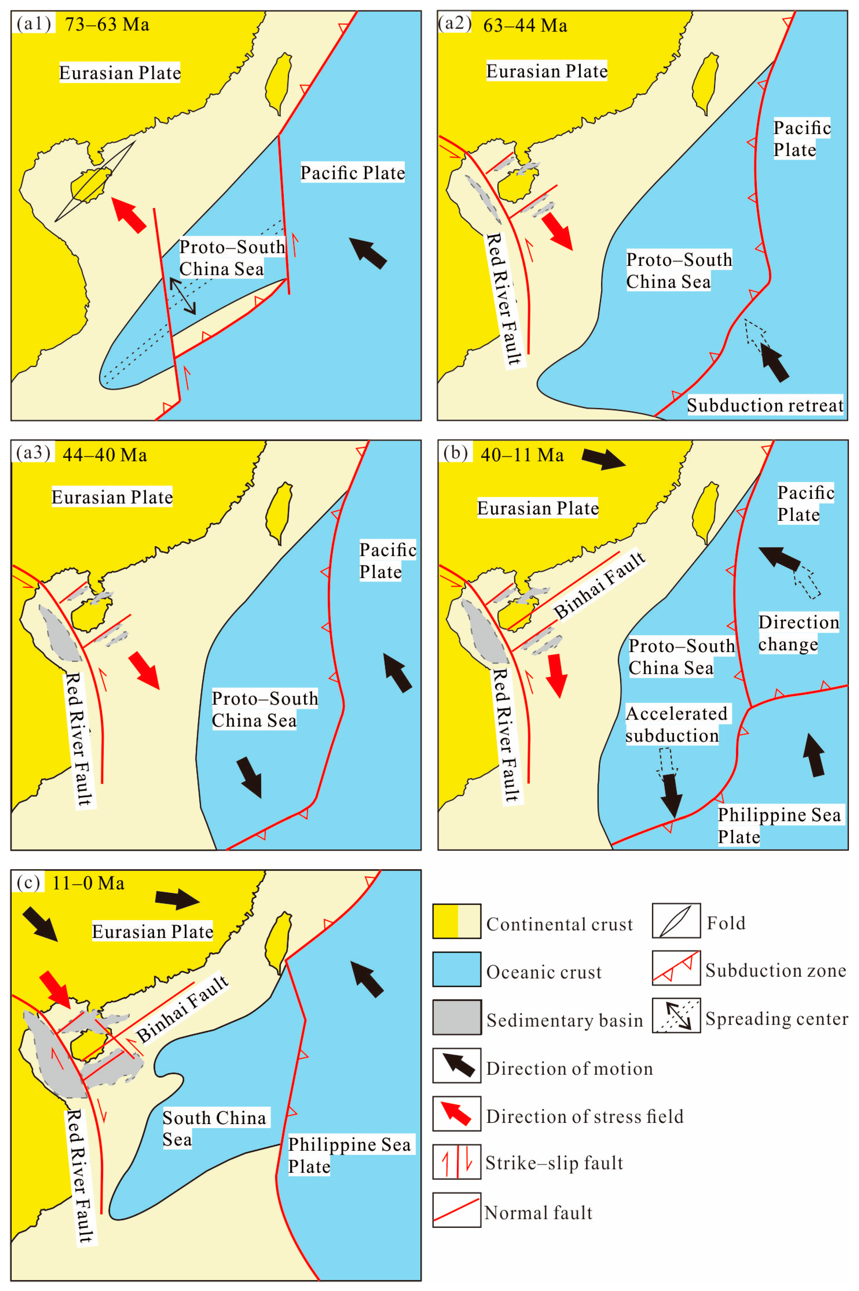
5.1. Late Cretaceous to Middle Eocene Episodic Rapid Uplift and Denudation
5.2. Middle Eocene to Middle Miocene Slow Denudation
5.3. Middle Miocene to Present Rapid Cooling and Denudation
6. Conclusions
Author Contributions
Funding
Data Availability Statement
Acknowledgments
Conflicts of Interest
References
- Metcalfe, I. Gondwana dispersion and Asian accretion: Tectonic and palaeogeographic evolution of eastern Tethys. J. Asian Earth Sci. 2013, 66, 1–33. [Google Scholar] [CrossRef]
- Hall, R. Late Jurassic–Cenozoic reconstructions of the Indonesian region and the Indian Ocean. Tectonophysics 2012, 570–571, 1–41. [Google Scholar] [CrossRef]
- Lei, C.; Ren, J.; Pang, X. Rift structures and its related unconformities on and adjacent the Dongsha Rise: Insights into the nature of the high-velocity layer in the northern South China Sea. Mar. Geophys. Res. 2019, 40, 99–110. [Google Scholar] [CrossRef]
- Wu, S.; Lu, X.; Li, G.; Li, G. Tectonics and discrepant evolution of Cenozoicsedimentary basins adjacent Hainan Island. Acta Geol. Sin. 2024, 98, 16–30, (In Chinese with English Abstract). [Google Scholar]
- Shi, X.; Kohn, B.; Spencer, S.; Guo, X.; Li, Y.; Yang, X.; Shi, H.; Gleadow, A. Cenozoic denudation history of southern Hainan Island, South China Sea: Constraints from low temperature thermochronology. Tectonophysics 2011, 504, 100–115. [Google Scholar] [CrossRef]
- Shi, X.; Kohn, B.; Yu, C.; Tian, Y.; Li, G.; Zhao, P. Thermo-tectonic history of coastal NW South China Sea: A low-temperature thermochronology study. Tectonophysics 2022, 833, 229–344. [Google Scholar] [CrossRef]
- Yan, Y.; Carter, A.; Palk, C.; Brichau, S.; Hu, X. Understanding sedimentation in the Song Hong–Yinggehai Basin, South China Sea. Geochem. Geophys. Geosyst. 2011, 12, Q06014. [Google Scholar] [CrossRef]
- Zhou, J.; Li, S.; Liu, Y.; Liu, B.; Li, W.; Wang, G.; Jiang, L.; Zhou, T.; Li, Z.; Feng, Z. Differential Uplift Triggered Basin-And-Range System: Evidence From Low-Temperature Thermochronology in Eastern NE Asia. Tectonics 2024, 43, e2023TC007857. [Google Scholar] [CrossRef]
- Wang, X.; Zattin, M.; Yang, Y.; Tao, J.; Liu, H.; Zhang, Y.; Wang, H.; Pang, B.; Wang, L.; Ji, M. Multiple Exhumation Stages During the Cenozoic Evolution of the Northeast Tibetan Plateau. Tectonics 2024, 43, e2023TC007850. [Google Scholar] [CrossRef]
- Lin, D.; Wan, S.; Hu, Z.; Lyu, C.; Shan, Q.; Liang, X.; Wei, C.; Yuan, Q.; Peng, G. Geochemical characteristics of bimodal intrusive complex in Baolun gold deposit, Hainan island and its implications for regional gold mineralization. Miner. Depos. 2023, 42, 1229–1246, (In Chinese with English Abstract). [Google Scholar] [CrossRef]
- Cai, J.; Wu, C.; Xu, D.; Hou, M.; Shan, Q.; Zhu, Y.; Lin, D. Structural analysis of the Baolun gold deposit, Hainan Island, South China: Implications for metallogeny. Ore Geol. Rev. 2017, 89, 253–269. [Google Scholar] [CrossRef]
- Xie, C.; Zhu, J.; Ding, S.; Zhang, Y.; Chen, M.; Fu, Y.; Fu, T.; Lin, Z. Age and petrogenesis of the Jianfengling granite and its relationship to metallogenesis of the Baolun gold deposit, Hainan Island. Acta Petrol. Sin. 2006, 22, 2493–2508, (In Chinese with English Abstract). [Google Scholar]
- Gallagher, K.; Brown, R.; Johnson, C. Fission track analysis and its applications to geological problems. Annu. Rev. Earth Planet. Sci. 1998, 26, 519–572. [Google Scholar] [CrossRef]
- Reiners, P.W.; Brandon, M.T. Using thermochronology to understand orogenic erosion. Annu. Rev. Earth Planet. Sci. 2006, 34, 419–466. [Google Scholar] [CrossRef]
- Gao, P.; Hu, J.; Hu, S. Mesozoic and Cenozoic Tectono-Thermal Reconstruction of the Southern Ordos Basin: Revealed by Apatite Fission Track and (U-Th)/He Dating. Minerals 2024, 14, 172. [Google Scholar] [CrossRef]
- Li, S.; Yuan, W.; Zhao, Z.; Zhang, A.; Dong, G.; Li, X.; Sun, W. Process and Mechanism of Exhumation in the Southern Altai Mountains, Northwest China. Minerals 2024, 14, 1234. [Google Scholar] [CrossRef]
- Wang, Y. Features of Hainan Island coastal environment. Mar. Geol. Lett. 2002, 18, 1–9. [Google Scholar]
- Liu, Y.; Fang, N.; Wang, Z. The geochemical characteristics of Cretaceous volcanics in southern Hainan Island and implications for tectonic evolution in the South China Sea. Front. Earth Sci. 2023, 11, 1251953. [Google Scholar] [CrossRef]
- Zhang, L.; Cui, X.; Yang, Y.; Chen, S.; Zhao, B.; Deng, X. Precambrian Tectonic Affinity of Hainan and Its Evolution from Columbia to Rodinia. Minerals 2023, 13, 1237. [Google Scholar] [CrossRef]
- He, H.; Wang, Y.; Cawood, P.A.; Qian, X.; Zhang, Y.; Zhao, G. Permo-Triassic granitoids, Hainan Island, link to Paleotethyan not Paleopacific tectonics. Geol. Soc. Am. Bull. 2020, 132, 2067–2083. [Google Scholar] [CrossRef]
- Yan, Q.; Shi, X.; Castillo, P.R. The late Mesozoic-Cenozoic tectonic evolution of the South China Sea: A petrologic perspective. J. Asian Earth Sci. 2014, 85, 178–201. [Google Scholar] [CrossRef]
- Cullen, A.; Reemst, P.; Henstra, G.; Gozzard, S.; Ray, A. Rifting of the South China Sea: New perspectives. Pet. Geosci. 2010, 16, 273–282. [Google Scholar] [CrossRef]
- Jiang, X.; Dilek, Y.; Li, X. Cretaceous magmatic arc in Hainan and the peri-South China Sea as evidenced by geochemical fingerprinting of granitoids in the region. Geosci. Front. 2024, 15, 101866. [Google Scholar] [CrossRef]
- Bellemans, F.; De, F.; Van Den, P. Composition of SRM and CN U-doped glasses: Significance for their use as thermal neutron fluence monitors in fission track dating. Radiat. Meas. 1995, 24, 153–160. [Google Scholar] [CrossRef]
- Yuan, W.; Dong, J.; Shicheng, W.; Carter, A. Apatite fission track evidence for Neogene uplift in the eastern Kunlun Mountains, northern Qinghai–Tibet Plateau, China. J. Asian Earth Sci. 2006, 27, 847–856. [Google Scholar] [CrossRef]
- Cao, K.; Replumaz, A.; Tian, Y.; Husson, L.; Wang, G.; Shen, T.; Reiners, P.; Bernet, M.; Beek, P.v.d. Southwestward growth of plateau surfaces in eastern Tibet. Earth-Sci. Rev. 2022, 232, 104160. [Google Scholar] [CrossRef]
- Hurford, A.J. Standardization of fission track dating calibration: Recommendation by the Fission Track Working Group of the IUGS Subcommission on Geochronology. Chem. Geol. Isot. Geosci. Sect. 1990, 80, 171–178. [Google Scholar] [CrossRef]
- Ketcham, R.A.; Carter, A.; Donelick, R.A.; Barbarand, J.; Hurford, A.J. Improved modeling of fission-track annealing in apatite. Am. Mineral. 2007, 92, 799–810. [Google Scholar] [CrossRef]
- Bernet, M. A field-based estimate of the zircon fission-track closure temperature. Chem. Geol. 2009, 259, 181–189. [Google Scholar] [CrossRef]
- Wagner, G.A. Cooling ages derived by apatite fission-track, mica Rb-Sr and K-Ar dating; the uplift and cooling history of the Central Alps. Mem. Inst. Geol. Mineral. Univ. Padova 1977, 30, 1–27. [Google Scholar]
- Ye, Z.; Yin, B.; Liu, J.; Wang, A.; Yan, Q. Uplift and denudation of Mt Sanqingshan Geopark, Jiangxi Province, China. Int. Geol. Rev. 2014, 56, 1873–1883. [Google Scholar] [CrossRef]
- Sobel, E.R.; Strecker, M.R. Uplift, exhumation and precipitation: Tectonic and climatic control of Late Cenozoic landscape evolution in the northern Sierras Pampeanas, Argentina. Basin Res. 2003, 15, 431–451. [Google Scholar] [CrossRef]
- Yuan, W.M.; Yang, Z.Q.; Zhang, Z.C.; Deng, J. The uplifting and denudation of main Huangshan Mountains, Anhui Province, China. Sci. Sin. 2011, 54, 1168–1176. [Google Scholar] [CrossRef]
- Shi, J.; Han, S.; Du, J.; Han, J.; Sun, D.; Hu, D. Surface process responses to the expansion of the northern South China Sea:Age evidence of apatite fission tracks from Wuzhi Mountains, Hainan Island. Acta Geol. Sin. 2024, 98, 421–432, (In Chinese with English Abstract). [Google Scholar] [CrossRef]
- Zhou, X.; Sun, T.; Shen, W.; Shu, L.; Niu, Y. Petrogenesis of Mesozoic granitoids and volcanic rocks in South China: A response to tectonic evolution. Epis. J. Int. Geosci. 2006, 29, 26–33. [Google Scholar] [CrossRef]
- Ren, J.; Tamaki, K.; Li, S.; Zhang, J. Late Mesozoic and Cenozoic rifting and its dynamic setting in Eastern China and adjacent areas. Tectonophysics 2002, 344, 175–205. [Google Scholar] [CrossRef]
- Jianye, R. Genetic dynamics of China offshore cenozoic basins. Earth Sci. 2018, 43, 3337–3361, (In Chinese with English Abstract). [Google Scholar]
- Suo, Y.; Li, S.; Jin, C.; Zhang, Y.; Zhou, J.; Li, X.; Wang, P.; Liu, Z.; Wang, X.; Somerville, I. Eastward tectonic migration and transition of the Jurassic-Cretaceous Andean-type continental margin along Southeast China. Earth-Sci. Rev. 2019, 196, 102884. [Google Scholar] [CrossRef]
- Xu, Z.; Yang, J.; Li, H.; Ji, S.; Zhang, Z.; Yan, L. On the Tectonics of the India-Asia Collision. Acta Geol. Sin. 2011, 85, 1–33, (In Chinese with English Abstract). [Google Scholar] [CrossRef]
- Lin, D.; Zheng, Y.; Hu, Z.; Wei, C.; Yuan, Q. Tectonic activity history and its dynamic mechanism of the Binhai fault, Hainan Island: New evidences from apatite and zircon fission track analyses. Acta Geol. Sin. 2024, 98, 1–13, (In Chinese with English Abstract). [Google Scholar] [CrossRef]
- Xing, G.; Chen, R.; Yang, Z.; Zhou, Y.; Li, L.; Jiang, Y.; Chen, Z. Characteristics and tectonic setting of Late Cretaceous volcanic magmatism in the coastal Southeast China. Acta Petrol. Sin. 2009, 25, 77–91, (In Chinese with English Abstract). [Google Scholar]
- Wu, J.; Suppe, J.; Lu, R.; Kanda, R. Philippine Sea and East Asian plate tectonics since 52 Ma constrained by new subducted slab reconstruction methods. J. Geophys. Res. Solid Earth 2016, 121, 4670–4741. [Google Scholar] [CrossRef]
- Tapponnier, P.; Lacassin, R.; Leloup, P.H.; Schärer, U.; Zhong, D.; Wu, H.; Liu, X.; Ji, S.; Zhang, L.; Zhong, J. The Ailao Shan/Red River metamorphic belt: Tertiary left-lateral shear between Indochina and South China. Nature 1990, 343, 431–437. [Google Scholar] [CrossRef]
- Patriat, P.; Achache, J. India–Eurasia collision chronology has implications for crustal shortening and driving mechanism of plates. Nature 1984, 311, 615–621. [Google Scholar] [CrossRef]
- Wang, X.; Suo, Y.; Li, S.; Cao, X.; Li, X.; Zhou, J.; Wang, P.; Chong, J. Cenozoic uplift history and its dynamic mechanism along the eastern continental margin of South China. Acta Petrol. Sin. 2020, 36, 1803–1820, (In Chinese with English Abstract). [Google Scholar]
- Hall, R. Australia–SE Asia collision: Plate tectonics and crustal flow. Geol. Soc. Lond. Spec. Publ. 2011, 355, 75–109. [Google Scholar] [CrossRef]
- Taylor, B.; Hayes, D.E. Origin and history of the South China Sea basin. Geophys. Monogr. Ser. 1983, 27, 23–56. [Google Scholar]
- Clift, P.D.; Sun, Z. The sedimentary and tectonic evolution of the Yinggehai–Song Hong basin and the southern Hainan margin, South China Sea: Implications for Tibetan uplift and monsoon intensification. J. Geophys. Res. Solid Earth 2006, 111, B06405. [Google Scholar] [CrossRef]
- Li, D.; Jiang, X.; Gong, W.; Li, C. Tectonic uplift along the northeastern margin of the Qinghai-Tibetan Plateau: Constraints from the lithofacies sequence and deposition rate of the Qaidam Basin. Tectonophysics 2022, 827, 229279. [Google Scholar] [CrossRef]
- Li, S.; Suo, Y.; Liu, X.; Dai, L.; Yu, S.; Zhao, S.; Ma, Y.; Wang, X.; Cheng, S.; An, H.; et al. Basin dynamics and basin groups of the South China Sea. Mar. Geol. Quat. Geol. 2012, 32, 55–78, (In Chinese with English Abstract). [Google Scholar] [CrossRef]
- Fu, L.; Shen, Z.; He, L.; Dong, C.; Cheng, X.; Tang, L.; Yang, S. Cretaceous Paleomagnetic Results from Hainan Island and Its Tectonic Implications. Acta Geol. Sin. 2010, 84, 183–194, (In Chinese with English Abstract). [Google Scholar] [CrossRef]
- Zheng, Y.; Pan, J.; Li, H.; Wang, Y.; Gong, Z.; Bai, M. Formation of the Great Bend and Enhanced Quaternary Incision of the Upper Yangtze River: New Insights from Low-Temperature Thermochronology and Tributary Morphology. Lithosphere 2024, 2023, 1–18. [Google Scholar] [CrossRef]
- Clift, P.D.; Wan, S.; Blusztajn, J. Reconstructing chemical weathering, physical erosion and monsoon intensity since 25 Ma in the northern South China Sea: A review of competing proxies. Earth-Sci. Rev. 2014, 130, 86–102. [Google Scholar] [CrossRef]


| Sample | Elevation (m) | Analysis Method | Number of Grains | ρs (105/cm2) (Ns) | ρi (105/cm2) (Ni) | ρd (105/cm2) (Nd) | P(χ2) (%) | Central Age (Ma) | Pooled Age (Ma) | L (µm) (N) |
|---|---|---|---|---|---|---|---|---|---|---|
| JFL01 | 1404 | AFT | 22 | 6.2 (388) | 16.1 (1002) | 6.9 (5045) | 100 | 48.3 ± 5.8 | 43.9 ± 4.4 | 11.9 ± 1.0 (14) |
| JFL06 | 1083 | AFT | 27 | 5.6 (346) | 15.1 (937) | 6.8 (5043) | 100 | 39.1 ± 4.8 | 41.7 ± 4.3 | 12.0 ± 1.1 (14) |
| JFL08 | 871 | AFT | 41 | 3.1 (637) | 10.2 (1575) | 6.8 (5039) | 100 | 28.5 ± 4.3 | 33.7 ± 3.8 | 12.0 ± 1.2 (24) |
| JFL09 | 707 | AFT | 23 | 6.5 (406) | 18.2 (1133) | 6.7 (5037) | 100 | 40.9 ± 5.3 | 39.8 ± 4.0 | 12.7 ± 1.5 (14) |
| JFL07 | 570 | AFT | 28 | 5.7 (356) | 15.8 (985) | 6.8 (5041) | 100 | 38.7 ± 5.0 | 40.5 ± 4.1 | 12.6 ± 1.1 (24) |
| JFL10 | 348 | AFT | 30 | 4.8 (296) | 17.5 (1575) | 6.7 (5035) | 100 | 29.3 ± 3.7 | 30.0 ± 3.0 | 12.7 ± 1.3 (23) |
| JFL11 | 145 | AFT | 25 | 7.8 (484) | 44.2 (2749) | 6.6 (5033) | 100 | 18.1 ± 2.0 | 19.4 ± 1.8 | 12.3 ± 1.2 (41) |
| JFL01 | 1404 | ZFT | 24 | 6.1 (1742) | 1.6 (456) | 4532 (5221) | 89 | 115 ± 11 | 108 ± 8 | - |
| JFL06 | 1083 | ZFT | 23 | 6.3 (1783) | 1.9 (554) | 4520 (5220) | 92 | 88 ± 8 | 92 ± 7 | - |
| JFL08 | 871 | ZFT | 22 | 3.8 (1318) | 0.9 (318) | 4494 (5218) | 98 | 120 ± 13 | 117 ± 8 | - |
| JFL07 | 570 | ZFT | 25 | 5.9 (1689) | 2.7 (762) | 4507 (5719) | 90 | 64 ± 5 | 63 ± 4 | - |
| JFL11 | 145 | ZFT | 25 | 9.8 (2786) | 3.8 (1078) | 4482 (5217) | 71 | 72 ± 6 | 73 ± 5 | - |
Disclaimer/Publisher’s Note: The statements, opinions and data contained in all publications are solely those of the individual author(s) and contributor(s) and not of MDPI and/or the editor(s). MDPI and/or the editor(s) disclaim responsibility for any injury to people or property resulting from any ideas, methods, instructions or products referred to in the content. |
© 2025 by the authors. Licensee MDPI, Basel, Switzerland. This article is an open access article distributed under the terms and conditions of the Creative Commons Attribution (CC BY) license (https://creativecommons.org/licenses/by/4.0/).
Share and Cite
Lin, D.; Xue, G.; Zheng, Y.; Zhang, G.; Hu, Z.; Wei, C.; Zhang, Z.; Yuan, Q. The Uplift and Denudation History of the Jianfeng Pluton on Hainan Island, China. Minerals 2025, 15, 320. https://doi.org/10.3390/min15030320
Lin D, Xue G, Zheng Y, Zhang G, Hu Z, Wei C, Zhang Z, Yuan Q. The Uplift and Denudation History of the Jianfeng Pluton on Hainan Island, China. Minerals. 2025; 15(3):320. https://doi.org/10.3390/min15030320
Chicago/Turabian StyleLin, Di, Guicheng Xue, Yong Zheng, Gucheng Zhang, Zailong Hu, Changxin Wei, Zhizhuang Zhang, and Qinmin Yuan. 2025. "The Uplift and Denudation History of the Jianfeng Pluton on Hainan Island, China" Minerals 15, no. 3: 320. https://doi.org/10.3390/min15030320
APA StyleLin, D., Xue, G., Zheng, Y., Zhang, G., Hu, Z., Wei, C., Zhang, Z., & Yuan, Q. (2025). The Uplift and Denudation History of the Jianfeng Pluton on Hainan Island, China. Minerals, 15(3), 320. https://doi.org/10.3390/min15030320