
Differential Evolution and Main Controlling Factors of Inner-Platform Carbonate Reservoirs in Restricted–Evaporative Environment: A Case Study of O2m56 in the Ordos Basin, North China
Abstract

1. Introduction
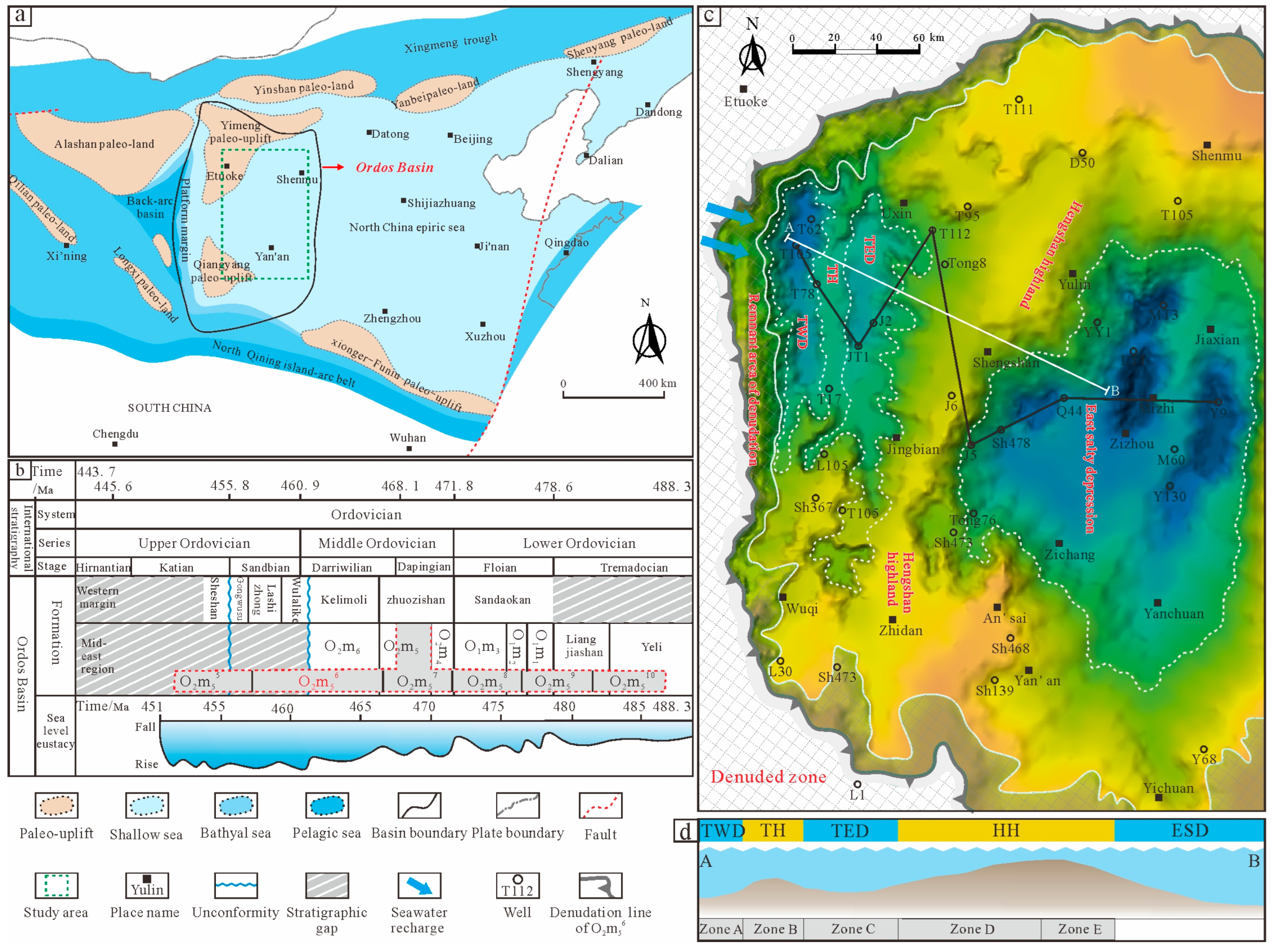
2. Geologic Setting
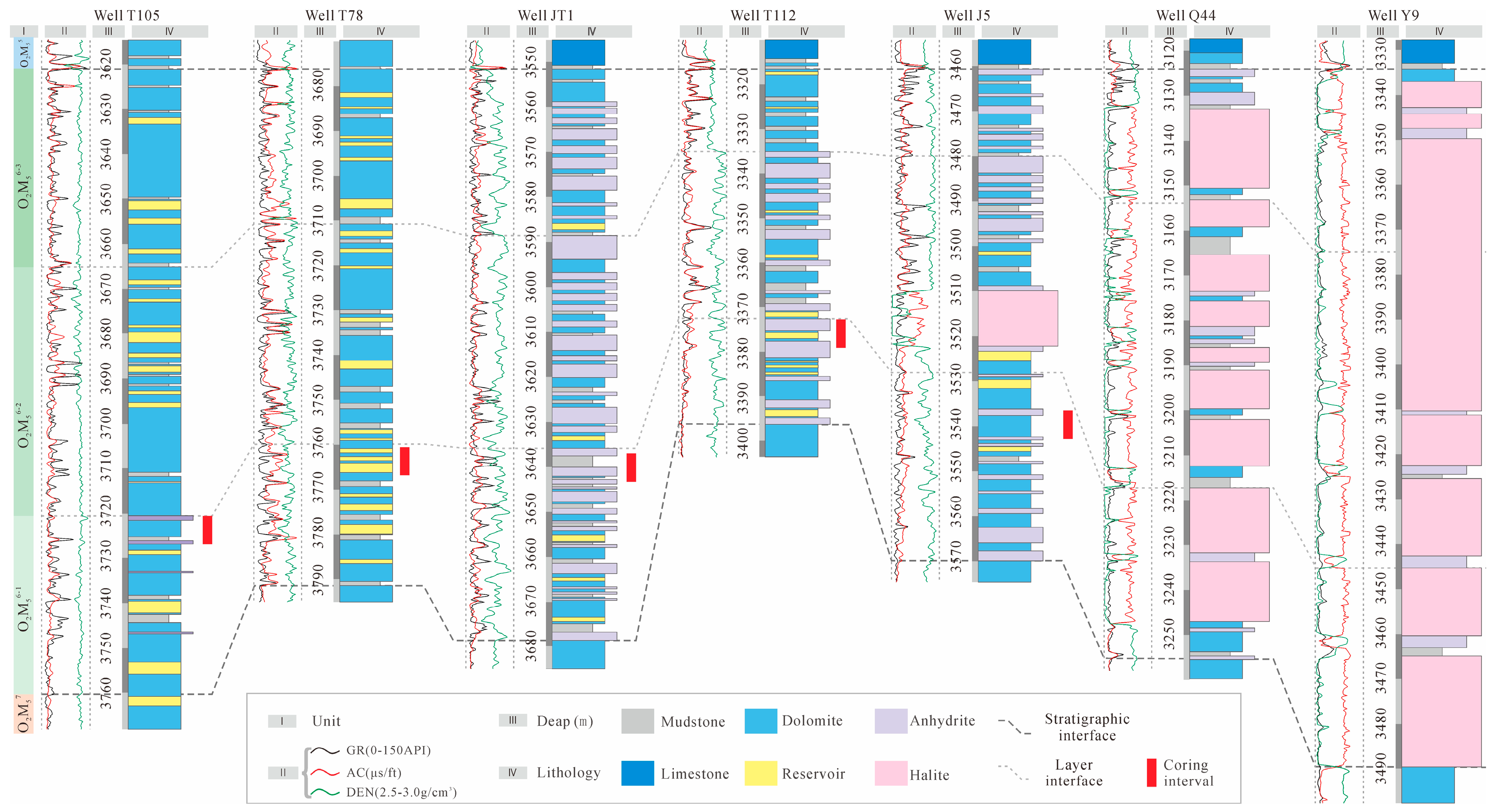
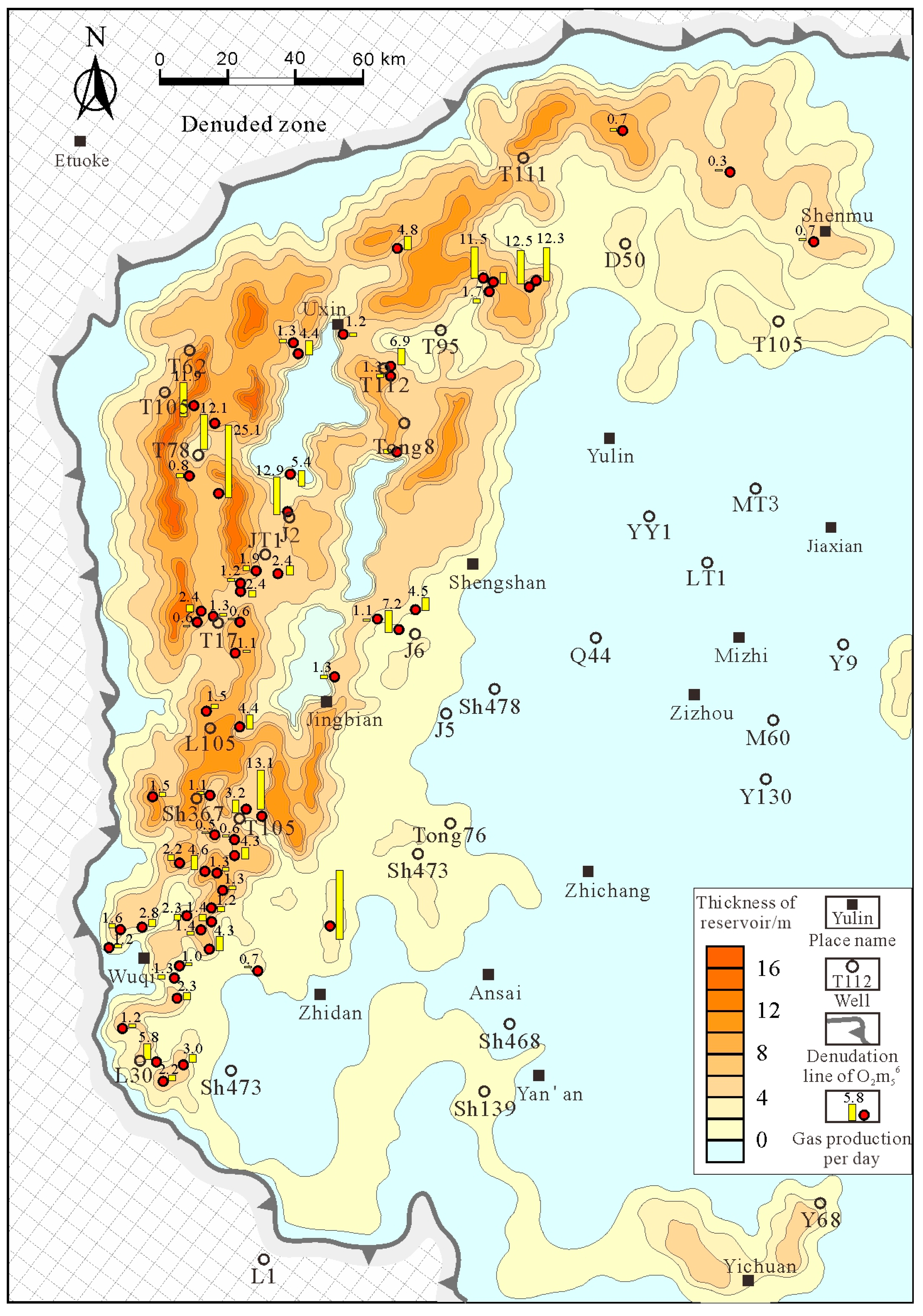
3. Samples and Methodology
4. Results
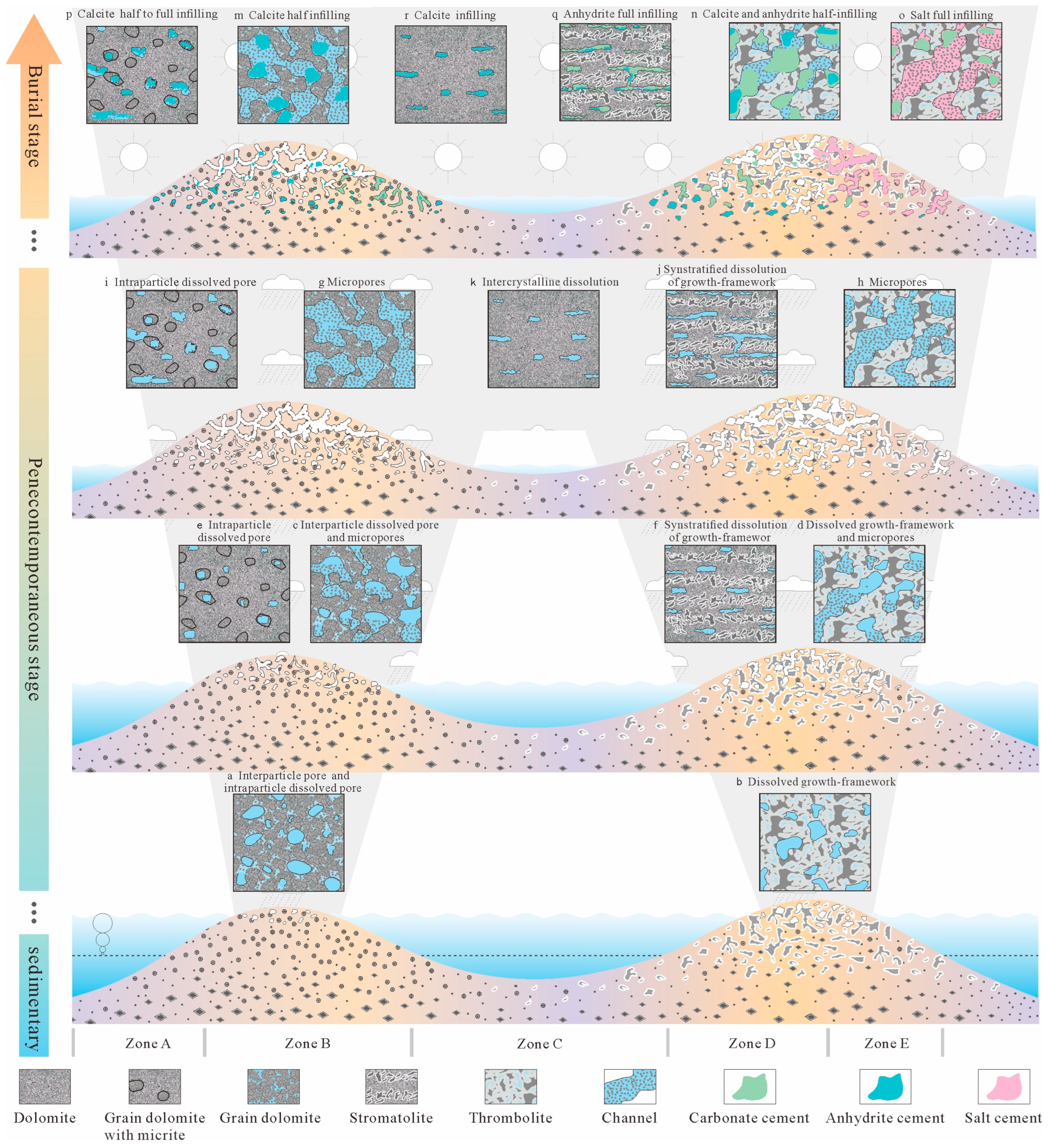
4.1. Facies Sequences
- (1)
- Zone A
- (2)
- Zone B
- (3)
- Zone C
- (4)
- Zone D
- (5)
- Zone E
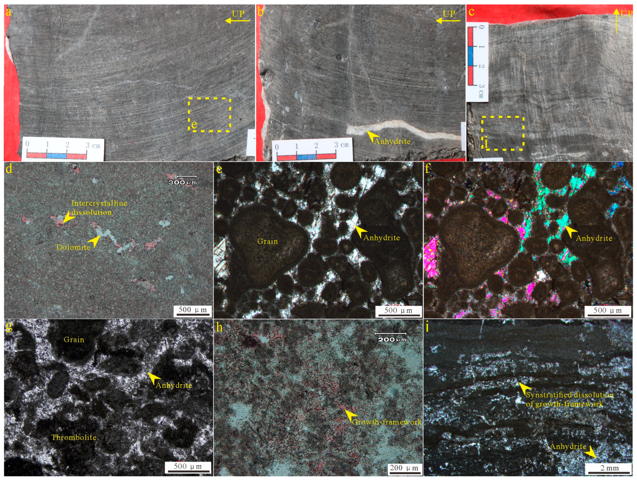
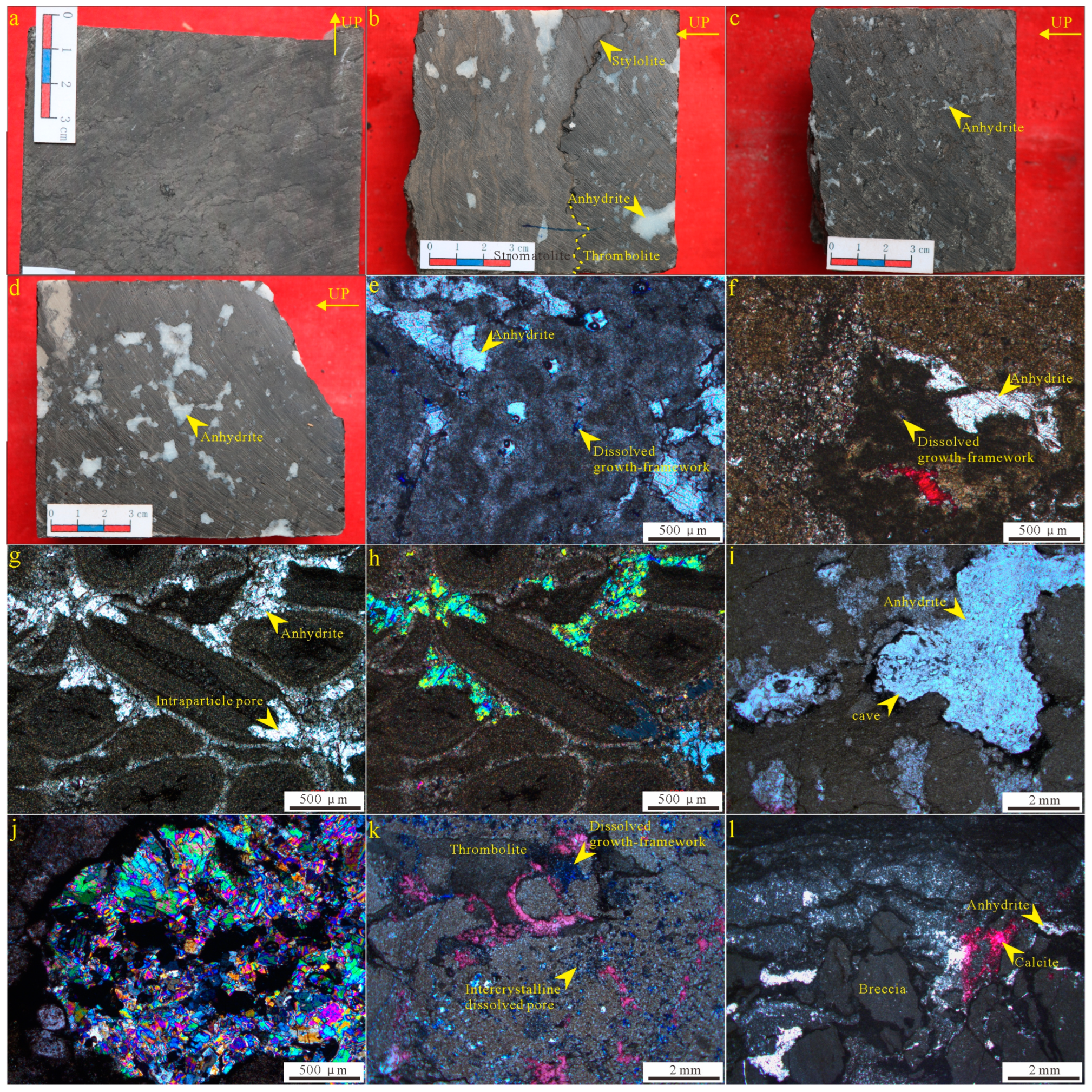
4.2. Types and Physical Properties of Reservoirs
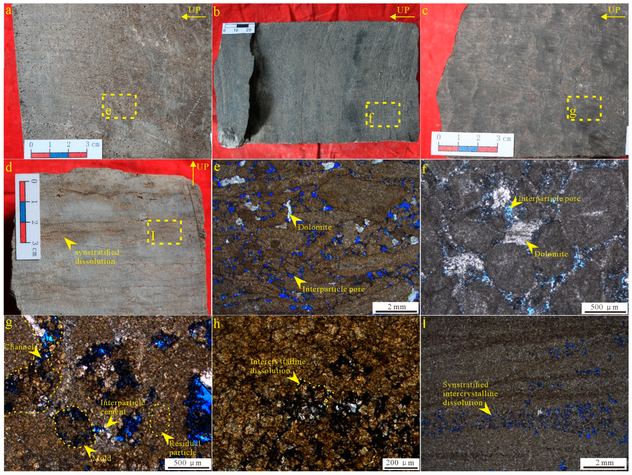
4.2.1. Types and Characteristics of Reservoir Rocks
- (1)
- Grain dolomite
- (2)
- Microbial dolomite
- (3)
- Crystalline dolomite
- (4)
- Karst breccia
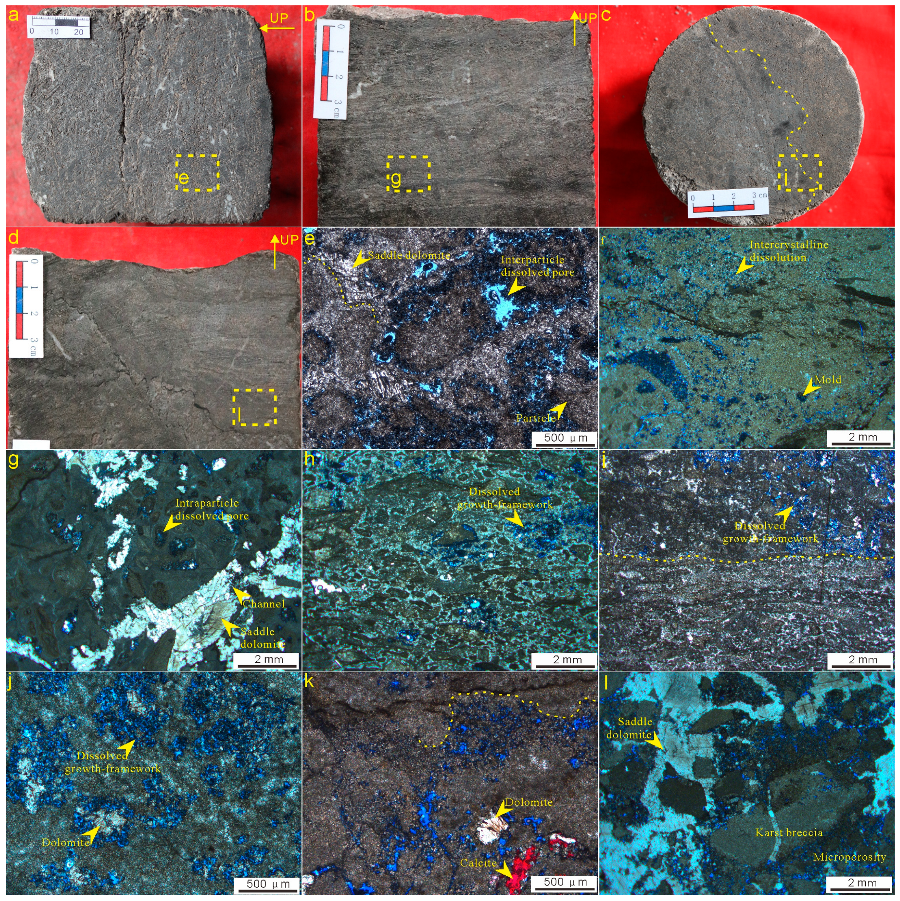
4.2.2. Types and Characteristics of Reservoir Spaces
- (1)
- Interparticle (dissolved) pores
- (2)
- Intraparticle dissolved pores and moldic pores
- (3)
- Growth-framework pores
- (4)
- Intercrystalline (dissolved) pores
- (5)
- Micropores between vadose silt in karst channels
4.2.3. Comparison of Reservoir Physical Properties in Zones A–E
4.3. Types of Infillings Within Pores
- (1)
- Vadose silt
- (2)
- Calcite and dolomite cements
- (3)
- Anhydrite cements
- (4)
- Halite cements
5. Discussion
5.1. Main Controlling Factors for Reservoir Development
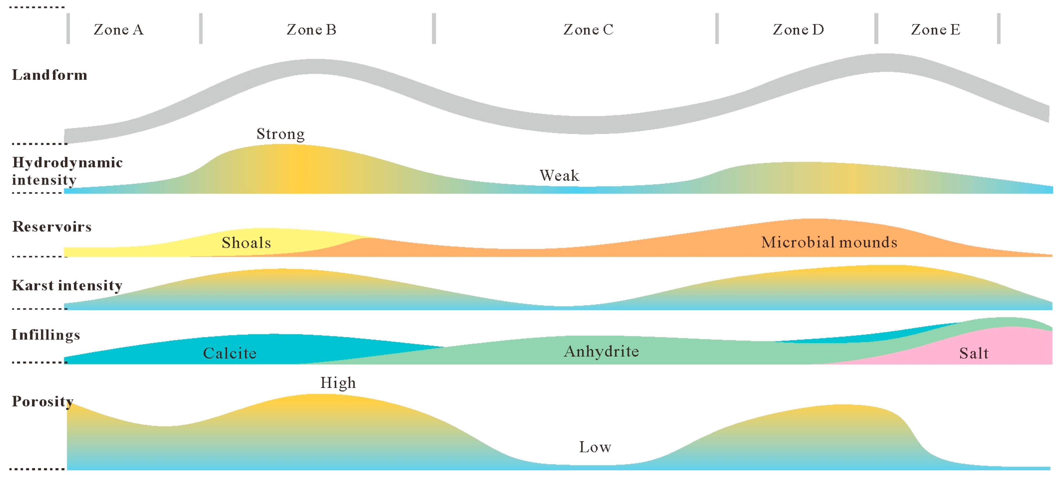
5.1.1. Coupling of Sea-Level Fluctuations with Sedimentary Landforms Controls Reservoir Types
5.1.2. Penecontemporaneous Karstification Controls Pore Morphology and Distribution
5.2. Differential Preservation Mechanism of Reservoirs
5.3. Differential Evolution Paths of Reservoirs in Geomorphic Units
6. Conclusions
- Shoal and microbial mound reservoirs developed in highlands. However, the dolomitic restricted lagoon (Zone A) and the gypsiferous evaporative lagoon (Zone C) developed in depressions.
- The physical properties of reservoirs in highlands are evidently superior to those found in depressions. In Zones A and B, various reservoir spaces are present, including interparticle dissolved pores, growth-framework dissolved pores, and channels. Concurrently, these reservoir spaces are filled with calcite, anhydrite, and halite, with a distribution that transitions from west to east.
- In a restricted–evaporative platform environment, highlands are more prone to karstification, which results in the formation of numerous dissolution pores and vugs that enhance the physical properties of reservoirs.
- The geomorphology of alternating uplift and depression in the study area constrains the gradual increase in seawater salinity from west to east. This process controls the distribution of reservoirs, with mounds deposited in the east and shoals deposited in the west. Moreover, the high salinity of pore water leads to the precipitation of evaporite minerals, which infills the pores and weakens the physical properties of the reservoirs. This mechanism is crucial for the preservation of the reservoirs. In general, the formation and preservation of reservoirs in O2m56 are influenced by a combination of factors, including reservoir rocks, karstification, and infilling features.
- An interesting phenomenon revealed in this study is that variations in the salinity of seawater from west to east lead to alterations in the types of cements found in reservoir spaces. This study mainly focused on the petrological characterization and the analysis of reservoir genetic models. The availability of abundant core samples in the study area facilitates a quantitative assessment of the formation and degradation of reservoirs under varying degrees of salinity of seawater in future investigations. Furthermore, when integrated with the geochemical characteristics of inter-salt reservoirs, this area presents an optimal subject for analyzing the properties of diagenetic fluids across different salinity environments.
Author Contributions
Funding
Data Availability Statement
Acknowledgments
Conflicts of Interest
References
- Warren, J.K. Evaporites through time: Tectonic, climatic and eustatic controls in marine and nonmarine deposit. Earth-Sci. Rev. 2010, 98, 217–268. [Google Scholar] [CrossRef]
- Hu, A.; Shen, A.; Yang, H. Dolomite genesis and reservoir-cap rock assemblage in carbonate evaporite paragenesis system. Pet. Explor. Dev. 2019, 46, 916–928. [Google Scholar] [CrossRef]
- Anjos Sylvia, M.C.; Sombra Cristiano, L.; Spadini Adali, R. Petroleum exploration and production in Brazil: From onshore to ultra-deepwaters. Pet. Explor. Dev. 2024, 51, 796–806. [Google Scholar]
- Dou, L.; Wen, Z.; Wang, Z. Sedimentary build-ups of pre-salt isolated carbonate platforms and formation of deep-water giant oil fields in Santos Basin, Brazil. Pet. Explor. Dev. 2024, 51, 829–840. [Google Scholar] [CrossRef]
- Afifi, A.M. Ghawar: The anatomy of the world’s largest oil field. AAPG Search Discov. 2005, 1–40. [Google Scholar]
- O’Hearn, T.; Elliott, S.; Samsonov, A. Karachaganak field, northern Pre-Caspian Basin, northwestern Kazakhstan. In Giant Oil and Gas Fields of the Decade 1990–1999: AAPG Memoir; Halbouty, M.T., Ed.; American Association of Petroleum Geologists: Tulsa, OK, USA, 2003; Volume 78, pp. 237–250. [Google Scholar]
- Schoenherr, J.; Reuning, L.; Kukla, P.A. Halite cementation and carbonate diagenesis of intra-salt reservoirs from the Late Neoproterozoic to Early Cambrian Ara Group (South Oman Salt Basin). Sedimentology 2009, 56, 567–589. [Google Scholar] [CrossRef]
- Jafarian, A.; Javanbakht, M.; Koeshidayatullah, A. Paleoenvironmental, diagenetic, and eustatic controls on the Permo–Triassic carbonate–evaporite reservoir quality, Upper Dalan and Kangan formations, Lavan Gas Field, Zagros Basin. Geol. J. 2018, 53, 1442–1457. [Google Scholar] [CrossRef]
- Amel, H.; Jafarian, A.; Husinec, A. Microfacies, depositional environment and diagenetic evolution controls on the reservoir quality of the Permian Upper Dalan Formation, Kish Gas Field, Zagros Basin. Mar. Pet. Geol. 2015, 67, 57–71. [Google Scholar] [CrossRef]
- Beigi, M.; Jafarian, A.; Javanbakht, M.H. Facies analysis, diagenesis and sequence stratigraphy of the carbonate-evaporite succession of the Upper Jurassic Surmeh Formation: Impacts on reservoir quality (Salman Oil Field, Persian Gulf, Iran). J. Afr. Earth Sci. 2017, 129, 179–194. [Google Scholar] [CrossRef]
- Sorento, T.; Olaussen, S.; Stemmerik, L. Controls on deposition of shallow marine carbonates and evaporites–lower Permian Gipshuken Formation, central Spitsbergen, Arctic Norway. Sedimentology 2020, 67, 207–238. [Google Scholar] [CrossRef]
- Zhong, S.; Tan, X.; Nie, W. High-frequency cyclic sequence of the Ma56 submember of Middle Ordovician Majiagou Formation in Ordos Basin: Indication for sea-level change and sedimentary differentiation effect of Hengshan uplift. J. Palaeogeogr. Chin. Ed. 2022, 24, 245–260. [Google Scholar]
- Brito, A.S.; Nogueira, A.C.R.; Dos Santos, R.F. High-frequency palaeoenvironmental changes in the mixed siliciclastic–carbonate sedimentary system from a lower Permian restricted basin (West Gondwana, southern Brazil). Sedimentology 2024, 71, 1515–1557. [Google Scholar] [CrossRef]
- Xiong, Y.; Tan, X.; Dong, G. Diagenetic differentiation in the Ordovician Majiagou Formation, Ordos Basin, China: Facies, geochemical and reservoir heterogeneity constraints. J. Pet. Sci. Eng. 2020, 191, 107179. [Google Scholar] [CrossRef]
- Liu, M.; Xiong, Y.; Xiong, C. Evolution of diagenetic system and its controls on the reservoir quality of pre-salt dolostone: The case of the Lower Ordovician Majiagou Formation in the central Ordos Basin, China. Mar. Pet. Geol. 2020, 122, 104674. [Google Scholar] [CrossRef]
- Luo, S.; Tan, X.; Chen, L. Dense brine refluxing: A new genetic interpretation of widespread anhydrite lumps in the Oligocene–Lower Miocene Asmari Formation of the Zagros foreland basin, NE Iraq. Mar. Pet. Geol. 2019, 101, 373–388. [Google Scholar] [CrossRef]
- Zhong, S.; Tan, X.; Hu, G. Control of paleogeographic pattern on sedimentary differentiation of evaporite-carbonate symbiotic system: A case study of the sixth sub-member of Ordovician Majiagou Formation M5 Member in central-eastern Ordos Basin, NW China. Pet. Explor. Dev. 2022, 49, 728–740. [Google Scholar] [CrossRef]
- Ding, C.; Gao, X.; Dong, G. Characteristics, genesis and distribution of the Ordovician pre-salt dolomite reservoirs in Ordos Basin. Mar. Orig. Pet. Geol. 2021, 26, 16–24. [Google Scholar]
- He, D.; Bao, H.; Kai, B. Critical tectonic modification periods and its geologic features of Ordos Basin and adjacent area. Acta Pet. Sin. 2021, 42, 1255–1269. [Google Scholar]
- Xu, Y.; Du, Y.; Cawood, P.A. Provenance record of a foreland basin: Detrital zircon U–Pb ages from Devonian strata in the North Qilian Orogenic Belt, China. Tectonophysics 2010, 495, 337–347. [Google Scholar] [CrossRef]
- Shi, J.; Shao, Y.; Zhang, S. Lithofacies paleogeography and sedimentary environment in Ordovician Majiagou Formation, eastern Ordos Basin. Nat. Gas Geosci. 2009, 20, 316324. [Google Scholar]
- Zhang, Y.; Xing, E.; Wang, Z. Evolution of lithofacies paleogeography in the Ordos Basin and its implication of potash formation. Acta Geol. Sin. 2015, 89, 1921–1935. [Google Scholar]
- Liu, Y.; Tan, X.; Liu, X. Sedimentary Characteristics and Distribution of Grain Shoals of Ma57 Submember in the Central Ordos Basin. Acta Sedimentol. Sin. 2018, 36, 796–806. [Google Scholar]
- Chen, A.; Xu, S.; Yang, S. Ordovician deep dolomite reservoirs in the intracratonic Ordos Basin, China: Depositional model and Diagenetic evolution. Energy Explor. Exploit. 2018, 36, 850–871. [Google Scholar] [CrossRef]
- Guo, Y.; Zhao, Z.; Fu, J. Sequence lithofacies paleogeography of the Ordovician in Ordos Basin, China. Acta Petrol. Sin. 2012, 33, 95–109. [Google Scholar]
- SYT6385-2016; Method for Determination of Rock Porosity and Permeability Under Overburden Pressure. National Energy Administration: Beijing, China, 2016. Available online: https://www.chinesestandard.net/PDF/English.aspx/SYT6385-2016?Redirect (accessed on 5 January 2025).
- Suarez-Gonzalez, P.; Benito, M.I.; Quijada, I.E. ‘Trapping and binding’: A review of the factors controlling the development of fossil agglutinated microbialites and their distribution in space and time. Earth-Sci. Rev. 2019, 194, 182–215. [Google Scholar] [CrossRef]
- Moore, C.H.; Wade, W.J. Carbonate Reservoirs: Porosity and Diagenesis in a Sequence Stratigraphic Framework, 2nd ed.; Elsevier: Amsterdam, The Netherlands, 2013. [Google Scholar]
- Xie, K.; Tan, X.; Feng, M. Eogenetic karst and its control on reservoirs in the Ordovician Majiagou Formation, eastern Sulige gas field, Ordos Basin, NW China. Pet. Explor. Dev. 2021, 47, 1246–1261. [Google Scholar] [CrossRef]
- Xiong, Y.; Tan, X.; Zhong, S. Dynamic paleokarst geochemistry within 130 Myr in the Middle Ordovician Shanganning carbonate platform, North China. Palaeogeogr. Palaeoclimatol. Palaeoecol. 2022, 591, 110879. [Google Scholar] [CrossRef]
- Aleali, M.; Rahimpour-Bonab, H.; Moussavi-Harami, R. Environmental and sequence stratigraphic implications of anhydrite textures: A case from the Lower Triassic of the Central Persian Gulf. J. Asian Earth Sci. 2013, 75, 110–125. [Google Scholar] [CrossRef]
- Liu, Y.; Hu, M.; Zhang, S. Characteristics and impacts on favorable reservoirs of carbonate ramp microfacies: A case study of the Middle-Lower Ordovician in Gucheng area, Tarim Basin, NW China. Pet. Explor. Dev. 2022, 49, 93–105. [Google Scholar] [CrossRef]
- Wei, L.; Zhao, J.; Su, Z. Distribution and depositional model of microbial carbonates in the Ordovician middle assemblage, Ordos Basin, NW China. Pet. Explor. Dev. 2021, 48, 1162–1174. [Google Scholar] [CrossRef]
- Liu, Y.; Hu, M.; Zhang, S. Types, structural evolution difference and petroleum geological significance of Cambrian-Ordovician carbonate platforms in Gucheng-Xiaotang area, Tarim Basin, NW China. Pet. Explor. Dev. 2022, 49, 884–895. [Google Scholar] [CrossRef]
- He, Q.; Shi, K.; Ma, Y. Evolution of rimmed carbonate platform architecture controlled by sea-level change: Insights from the Lower-Middle Cambrian of the Northern Tarim Basin, China. Mar. Pet. Geol. 2025, 171, 107215. [Google Scholar] [CrossRef]
- Zhang, B.; Liu, J. Classification and characteristics of karst reservoirs in China and related theories. Pet. Explor. Dev. 2009, 36, 12–29. [Google Scholar]
- Zhao, W.; Shen, A.; Hu, A. A Discussion on the geological background of marine carbonate reservoirs development in Tarim, Sichuan and Ordos Basin, China. Acta Pet. Sin. 2015, 31, 3495–3508. [Google Scholar]
- Shen, A.; Zhao, W.; Hu, A. Major factors controlling the development of marine carbonate reservoirs. Pet. Explor. Dev. 2015, 42, 545–554. [Google Scholar] [CrossRef]
- James, N.P.; Choquette, P.W. Paleokarst; Springer: New York, NY, USA, 1988; pp. 1–416. [Google Scholar]
- Xiao, D.; Tan, X.; Xi, A. An inland facies-controlled eogenetic karst of the carbonate reservoir in the Middle Permian Maokou Formation, southern Sichuan Basin, SW China. Mar. Pet. Geol. 2016, 72, 218–233. [Google Scholar] [CrossRef]
- Yılmaz, İ.Ö.; Altıner, D. Cyclic palaeokarst surfaces in Aptian peritidal carbonate successions (Taurides, southwest Turkey): Internal structure and response to mid-Aptian sea-level fall. Cretac. Res. 2006, 27, 814–827. [Google Scholar] [CrossRef]
- Baceta, J.I.; Wright, V.P.; Beavington-Penney, S.J.; Pujalte, V. Palaeohydrogeological control of palaeokarst macro-porosity genesis during a major sea-level lowstand: Danian of the Urbasa–Andia plateau, Navarra, North Spain. Sediment. Geol. 2007, 199, 141–169. [Google Scholar] [CrossRef]
- Loucks, R.G. Paleocave carbonate reservoirs: Origins, burial-depth modifications, spatial complexity, and reservoir implications. AAPG Bull. 1999, 83, 1795–1834. [Google Scholar]
- Warren, J. Dolomite: Occurrence, evolution and economically important associations. Earth-Sci. Rev. 2000, 52, 1–81. [Google Scholar] [CrossRef]
- Yang, J.; Zhang, J.; He, Z. Controlling factors of meteoric diagenesis in karst reservoirs: An example from the majiagou formation, ordos basin, China. Minerals 2023, 13, 812. [Google Scholar] [CrossRef]
- Wei, L.; Chen, H.; Guo, W. Wushen-Jingbian Paleo-uplift and its control on the Ordovician subsalt deposition and reservoirs in Ordos Basin. Oil Gas Geol. 2021, 42, 391–400+521. [Google Scholar]


| Geomorphic Unit | Reservoir Rocks | Main Reservoir Space Types | Infilling Features | Physical Properties | |
|---|---|---|---|---|---|
| Zone A | Mainly grain dolomite, along with a few crystalline dolomite and microbial dolomite | Mainly interparticle pores, with a few moldic pores (intraparticle dissolution) and intercrystalline dissolved pores | Pore-type space | Calcite and dolomite cements, and a minor quantity of vadose silts | Moderate |
| Zone B | Mainly interparticle dissolved pores, with a few growth-framework dissolved pores and intercrystalline dissolved pores | A minor quantity of carbonate cements | Excellent | ||
| Zone C | Grain dolomite and microbial dolomite | Interparticle pores and growth-framework pores, with a few dissolved pores | Pore- to fracture-type space | Anhydrite cements almost infilling | Poor |
| Zone D | Mainly microbial dolomite, along with a few binding dolarenite | Mainly growth-framework (dissolved) pores, with a few interparticle pores and residual dissolved micropores | Anhydrite or calcite partially infilling | Good | |
| Zone E | Moldic pores (anhydrite moldic pores/salt moldic pores), growth-framework pores, strong karst channels | Fracture-type space | Anhydrite and halite almost infilling | Poor | |
Disclaimer/Publisher’s Note: The statements, opinions and data contained in all publications are solely those of the individual author(s) and contributor(s) and not of MDPI and/or the editor(s). MDPI and/or the editor(s) disclaim responsibility for any injury to people or property resulting from any ideas, methods, instructions or products referred to in the content. |
© 2025 by the authors. Licensee MDPI, Basel, Switzerland. This article is an open access article distributed under the terms and conditions of the Creative Commons Attribution (CC BY) license (https://creativecommons.org/licenses/by/4.0/).
Share and Cite
Yang, M.; Tan, X.; Fei, Z.; Lu, Z.; Nie, W.; Xiong, Y.; Xiao, D.; Xu, J.; Zhong, S.; Yong, J. Differential Evolution and Main Controlling Factors of Inner-Platform Carbonate Reservoirs in Restricted–Evaporative Environment: A Case Study of O2m56 in the Ordos Basin, North China. Minerals 2025, 15, 236. https://doi.org/10.3390/min15030236
Yang M, Tan X, Fei Z, Lu Z, Nie W, Xiong Y, Xiao D, Xu J, Zhong S, Yong J. Differential Evolution and Main Controlling Factors of Inner-Platform Carbonate Reservoirs in Restricted–Evaporative Environment: A Case Study of O2m56 in the Ordos Basin, North China. Minerals. 2025; 15(3):236. https://doi.org/10.3390/min15030236
Chicago/Turabian StyleYang, Mengying, Xiucheng Tan, Zhaolei Fei, Zixing Lu, Wancai Nie, Ying Xiong, Di Xiao, Jie Xu, Shoukang Zhong, and Jingkang Yong. 2025. "Differential Evolution and Main Controlling Factors of Inner-Platform Carbonate Reservoirs in Restricted–Evaporative Environment: A Case Study of O2m56 in the Ordos Basin, North China" Minerals 15, no. 3: 236. https://doi.org/10.3390/min15030236
APA StyleYang, M., Tan, X., Fei, Z., Lu, Z., Nie, W., Xiong, Y., Xiao, D., Xu, J., Zhong, S., & Yong, J. (2025). Differential Evolution and Main Controlling Factors of Inner-Platform Carbonate Reservoirs in Restricted–Evaporative Environment: A Case Study of O2m56 in the Ordos Basin, North China. Minerals, 15(3), 236. https://doi.org/10.3390/min15030236